Avondale Park - Demolition of City Owned Structures at 3562 and 3588 Smith Avenue
https://search.heritageburnaby.ca/link/councilreport213
- Repository
- City of Burnaby Archives
- Report ID
- 66926
- Meeting Date
- 16-Apr-2007
- Format
- Council - Manager's Report
- Item No.
- 13
- Collection/Fonds
- City Council and Office of the City Clerk fonds
- Repository
- City of Burnaby Archives
- Report ID
- 66926
- Meeting Date
- 16-Apr-2007
- Format
- Council - Manager's Report
- Item No.
- 13
- Collection/Fonds
- City Council and Office of the City Clerk fonds
Documents
Burnaby's heritage : an inventory of buildings and structures
https://search.heritageburnaby.ca/link/museumlibrary5437
- Repository
- Burnaby Village Museum
- Author
- Luxton, Donald, 1954-
- Wolf, Jim
- Edition
- Rev.
- Publication Date
- 2011
- c2007
- Call Number
- 971.133 LUX COPY 1
s a n d S t r u c t u r e s
�Library and Archives Canada Cataloguing in Publication
Luxton, Donald, 1954-
Burnaby’s Heritage : an inventory of buildings and structures / Donald
Luxton, Jim Wolf.
Written by Donald Luxton & Jim Wolf
Includes bibliographical references and index.
ISBN 0-9692828-9-3
1
- Repository
- Burnaby Village Museum
- Collection
- Digital Reference Collection
- Material Type
- Book
- ISBN
- 0969282893
- Call Number
- 971.133 LUX COPY 1
- Edition
- Rev.
- Author
- Luxton, Donald, 1954-
- Wolf, Jim
- Place of Publication
- Burnaby, B.C.
- Publisher
- City of Burnaby
- Publication Date
- 2011
- c2007
- Physical Description
- 157 p. : ill. ; 28 cm.
- Library Subject (LOC)
- Architecture
- Historic buildings
- Buildings
- Historic sites
- Subjects
- Buildings
- Buildings - Heritage
- Notes
- Includes bibliographical references and index.
- 2 copies held: copy 1.
Digital Books
Capitol Hill Conservation Area - Demolition of City-Owned Structures at 5160 Scenic Highway
https://search.heritageburnaby.ca/link/councilreport49826
- Repository
- City of Burnaby Archives
- Report ID
- 67397
- Meeting Date
- 3-Mar-2008
- Format
- Council - Manager's Report
- Item No.
- 5
- Collection/Fonds
- City Council and Office of the City Clerk fonds
- Repository
- City of Burnaby Archives
- Report ID
- 67397
- Meeting Date
- 3-Mar-2008
- Format
- Council - Manager's Report
- Item No.
- 5
- Collection/Fonds
- City Council and Office of the City Clerk fonds
Documents
Deer Lake Brook Parkway - Demolition of Structures at 4940 Claude Avenue
https://search.heritageburnaby.ca/link/councilreport517
- Repository
- City of Burnaby Archives
- Report ID
- 66618
- Meeting Date
- 21-Aug-2006
- Format
- Council - Manager's Report
- Item No.
- 13
- Collection/Fonds
- City Council and Office of the City Clerk fonds
- Repository
- City of Burnaby Archives
- Report ID
- 66618
- Meeting Date
- 21-Aug-2006
- Format
- Council - Manager's Report
- Item No.
- 13
- Collection/Fonds
- City Council and Office of the City Clerk fonds
Documents
Deer Lake Brook Parkway - Demolition of Structures at 4958 Sperling Avenue, Lot 1, DL 79 and 85, Plan 9547
https://search.heritageburnaby.ca/link/councilreport159
- Repository
- City of Burnaby Archives
- Report ID
- 66997
- Meeting Date
- 28-May-2007
- Format
- Council - Manager's Report
- Item No.
- 1
- Collection/Fonds
- City Council and Office of the City Clerk fonds
- Repository
- City of Burnaby Archives
- Report ID
- 66997
- Meeting Date
- 28-May-2007
- Format
- Council - Manager's Report
- Item No.
- 1
- Collection/Fonds
- City Council and Office of the City Clerk fonds
Documents
Eastburn Park - Demolition of City Owned Structures at 7956 13th Avenue
https://search.heritageburnaby.ca/link/councilreport214
- Repository
- City of Burnaby Archives
- Report ID
- 66927
- Meeting Date
- 16-Apr-2007
- Format
- Council - Manager's Report
- Item No.
- 12
- Collection/Fonds
- City Council and Office of the City Clerk fonds
- Repository
- City of Burnaby Archives
- Report ID
- 66927
- Meeting Date
- 16-Apr-2007
- Format
- Council - Manager's Report
- Item No.
- 12
- Collection/Fonds
- City Council and Office of the City Clerk fonds
Documents
Ernie Winch Park - Demolition of City Structures at 7272, 7296 & 7316 14th Avenue
https://search.heritageburnaby.ca/link/councilreport1322
- Repository
- City of Burnaby Archives
- Report ID
- 65827
- Meeting Date
- 21-Mar-2005
- Format
- Council - Manager's Report
- Item No.
- 8
- Collection/Fonds
- City Council and Office of the City Clerk fonds
- Repository
- City of Burnaby Archives
- Report ID
- 65827
- Meeting Date
- 21-Mar-2005
- Format
- Council - Manager's Report
- Item No.
- 8
- Collection/Fonds
- City Council and Office of the City Clerk fonds
Documents
Ernie Winch Park - Demolition of Structures at 7311-7313 Thirteenth Avenue
https://search.heritageburnaby.ca/link/councilreport931
- Repository
- City of Burnaby Archives
- Report ID
- 66213
- Meeting Date
- 28-Nov-2005
- Format
- Council - Manager's Report
- Item No.
- 9
- Collection/Fonds
- City Council and Office of the City Clerk fonds
- Repository
- City of Burnaby Archives
- Report ID
- 66213
- Meeting Date
- 28-Nov-2005
- Format
- Council - Manager's Report
- Item No.
- 9
- Collection/Fonds
- City Council and Office of the City Clerk fonds
Documents
Graham Park - Demolition of Structures at 7975 Graham Avenue
https://search.heritageburnaby.ca/link/councilreport523
- Repository
- City of Burnaby Archives
- Report ID
- 66628
- Meeting Date
- 21-Aug-2006
- Format
- Council - Manager's Report
- Item No.
- 12
- Collection/Fonds
- City Council and Office of the City Clerk fonds
- Repository
- City of Burnaby Archives
- Report ID
- 66628
- Meeting Date
- 21-Aug-2006
- Format
- Council - Manager's Report
- Item No.
- 12
- Collection/Fonds
- City Council and Office of the City Clerk fonds
Documents
Inman Green Park - Demolition of Structures at 5442 and 5444 Inman Avenue
https://search.heritageburnaby.ca/link/councilreport590
- Repository
- City of Burnaby Archives
- Report ID
- 66548
- Meeting Date
- 26-Jun-2006
- Format
- Council - Manager's Report
- Item No.
- 18
- Collection/Fonds
- City Council and Office of the City Clerk fonds
- Repository
- City of Burnaby Archives
- Report ID
- 66548
- Meeting Date
- 26-Jun-2006
- Format
- Council - Manager's Report
- Item No.
- 18
- Collection/Fonds
- City Council and Office of the City Clerk fonds
Documents
Inman Green Park - Demolition of Structures at 5484 and 5516 Inman Avenue and 5415, 5449 and 5511/5513 Patterson Avenue
https://search.heritageburnaby.ca/link/councilreport49926
- Repository
- City of Burnaby Archives
- Report ID
- 67497
- Meeting Date
- 12-May-2008
- Format
- Council - Manager's Report
- Item No.
- 6
- Collection/Fonds
- City Council and Office of the City Clerk fonds
- Repository
- City of Burnaby Archives
- Report ID
- 67497
- Meeting Date
- 12-May-2008
- Format
- Council - Manager's Report
- Item No.
- 6
- Collection/Fonds
- City Council and Office of the City Clerk fonds
Documents
McPherson Park - Demolition of City Owned Structures at 5289 Rumble Street and 5310 Irmin Street
https://search.heritageburnaby.ca/link/councilreport28
- Repository
- City of Burnaby Archives
- Report ID
- 67114
- Meeting Date
- 27-Aug-2007
- Format
- Council - Manager's Report
- Item No.
- 15
- Collection/Fonds
- City Council and Office of the City Clerk fonds
- Repository
- City of Burnaby Archives
- Report ID
- 67114
- Meeting Date
- 27-Aug-2007
- Format
- Council - Manager's Report
- Item No.
- 15
- Collection/Fonds
- City Council and Office of the City Clerk fonds
Documents
Warner Loat Park - Demolition of City Owned Structures at 4048, 4082 and 4122 Piper Avenue
https://search.heritageburnaby.ca/link/councilreport344
- Repository
- City of Burnaby Archives
- Report ID
- 66819
- Meeting Date
- 22-Jan-2007
- Format
- Council - Manager's Report
- Item No.
- 9
- Collection/Fonds
- City Council and Office of the City Clerk fonds
- Repository
- City of Burnaby Archives
- Report ID
- 66819
- Meeting Date
- 22-Jan-2007
- Format
- Council - Manager's Report
- Item No.
- 9
- Collection/Fonds
- City Council and Office of the City Clerk fonds
Documents
West Sells Park - Demolition of Structures at 3978 Frances Street
https://search.heritageburnaby.ca/link/councilreport900
- Repository
- City of Burnaby Archives
- Report ID
- 66253
- Meeting Date
- 9-Jan-2006
- Format
- Council - Manager's Report
- Item No.
- 5
- Collection/Fonds
- City Council and Office of the City Clerk fonds
- Repository
- City of Burnaby Archives
- Report ID
- 66253
- Meeting Date
- 9-Jan-2006
- Format
- Council - Manager's Report
- Item No.
- 5
- Collection/Fonds
- City Council and Office of the City Clerk fonds
Documents
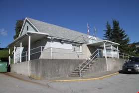
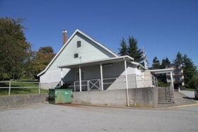
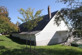
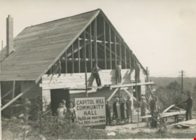
Capitol Hill Community Hall
https://search.heritageburnaby.ca/link/landmark563
- Repository
- Burnaby Heritage Planning
- Description
- Public building.
- Associated Dates
- 1948
- Street View URL
- Google Maps Street View
- Repository
- Burnaby Heritage Planning
- Geographic Access
- Howard Avenue
- Associated Dates
- 1948
- Description
- Public building.
- Heritage Value
- The Capitol Hill Community Hall was designed by local architect Harold Cullerne (1890-1976). After Cullerne returned from service during the First World War, he joined J.H. Bowman in a partnership that lasted from 1919 to 1934. After Bowman retired in 1934, Cullerne practiced on his own, continuing to work on schools and institutional buildings, such as the Art Deco Hollywood Theatre in Vancouver. In 1944, Cullerne designed a community hall for Capitol Hill; the scheme was delayed, and redesigned before it was finally built after the end of the Second World War. A simple front gabled roof hall structure, this hall is a monument to community spirit, erected by community members on a volunteer basis, and used for community events for over half a century. The hall replaced two earlier structures, both destroyed by fire, that had served the same purpose.
- Locality
- Capitol Hill
- Historic Neighbourhood
- Capitol Hill (Historic Neighbourhood)
- Planning Study Area
- Capitol Hill Area
- Architect
- Harold Cullerne
- Ownership
- Public (local)
- Street Address
- 361 Howard Avenue
- Street View URL
- Google Maps Street View
Images
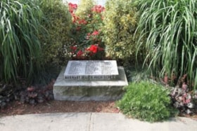
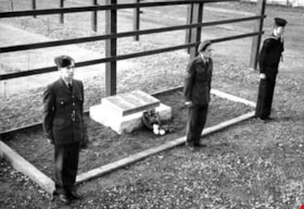
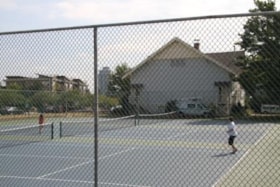
Burnaby South High School Cenotaph & Memorial Tennis Courts
https://search.heritageburnaby.ca/link/landmark547
- Repository
- Burnaby Heritage Planning
- Description
- This memorial comprises a cenotaph and three tennis courts: the former a monument of British Columbia granite inscribed with the names of fifty-one students of Burnaby South High School who lost their lives in the Second World War; and the latter a living memorial to these former students.
- Associated Dates
- 1948
- Formal Recognition
- Heritage Designation, Community Heritage Register
- Street View URL
- Google Maps Street View
- Repository
- Burnaby Heritage Planning
- Geographic Access
- Southoaks Crescent
- Associated Dates
- 1948
- Formal Recognition
- Heritage Designation, Community Heritage Register
- Enactment Type
- Bylaw No. 9807
- Enactment Date
- 23/11/1992
- Description
- This memorial comprises a cenotaph and three tennis courts: the former a monument of British Columbia granite inscribed with the names of fifty-one students of Burnaby South High School who lost their lives in the Second World War; and the latter a living memorial to these former students.
- Heritage Value
- This memorial is important for its spiritual, symbolic, and cultural associations for the former students of Burnaby South High School, and for all youth in the community. The cenotaph is of personal significance to the families of those who lost their lives. The unusual combination of cenotaph and living memorial - the tennis courts - represents a rare statement of a community's commitment to not allow the sacrifice of its youth to be forgotten by providing an active facility which draw people to the place on a regular basis rather than just on occasions of remembrance. As such it is an important symbol of a humanitarian ethic. In combination with the Kingsway East School, now rehabilitated as the Alan Emmott Centre, this memorial represents a valuable haven of green-space and recreation in the high-density urban development that now surrounds it.
- Defining Elements
- Key elements that define the heritage character of the Burnaby South High School Cenotaph & Memorial Tennis Courts include the: - location of the cenotaph adjacent to the living memorial - spatial association of this memorial and the remaining school building - physical fabric of both the granite monument and the tennis courts
- Historic Neighbourhood
- Edmonds (Historic Neighbourhood)
- Planning Study Area
- Kingsway-Beresford Area
- Function
- Primary Current--Public Feature
- Primary Historic--Public Feature
- Community
- Burnaby
- Cadastral Identifier
- P.I.D. No. 016-367-154 Legal Description: Lot 1, District Lot 96, Group 1 New Westminster District, Plan 86581
- Boundaries
- Burnaby South High School Cenotaph & Memorial Tennis Courts is comprised of a single municipally-owned property located at 6650 Southoaks Crescent, Burnaby.
- Area
- 6,070.00
- Contributing Resource
- Building
- Landscape Feature
- Structure
- Ownership
- Public (local)
- Documentation
- Heritage Site Files: PC77000 20. City of Burnaby Planning and Building Department, 4949 Canada Way, Burnaby, B.C., V5G 1M2
- Street Address
- 6650 Southoaks Crescent
- Street View URL
- Google Maps Street View
Images
Air Defence
https://search.heritageburnaby.ca/link/archivedescription34103
- Repository
- City of Burnaby Archives
- Date
- March 16, 1947
- Collection/Fonds
- Burnaby Historical Society fonds
- Description Level
- Item
- Physical Description
- 1 photograph : b&w negative ; 6.8 x 11.3 cm
- Scope and Content
- Photograph of the camp site for the Air Defence, 1942-1946, at Kitchener Street and Madison Avenue. This is part of the Willingdon Heights subdivision site.
- Repository
- City of Burnaby Archives
- Date
- March 16, 1947
- Collection/Fonds
- Burnaby Historical Society fonds
- Subseries
- Alfred Bingham subseries
- Physical Description
- 1 photograph : b&w negative ; 6.8 x 11.3 cm
- Description Level
- Item
- Record No.
- 010-019
- Access Restriction
- No restrictions
- Reproduction Restriction
- No known restrictions
- Accession Number
- BHS2007-04
- Scope and Content
- Photograph of the camp site for the Air Defence, 1942-1946, at Kitchener Street and Madison Avenue. This is part of the Willingdon Heights subdivision site.
- Media Type
- Photograph
- Photographer
- Bingham, Alfred "Alf"
- Notes
- Title based on contents of photograph
- Geographic Access
- Kitchener Street
- Madison Avenue
Images
Bird watchers at Piper Pier
https://search.heritageburnaby.ca/link/archivedescription96006
- Repository
- City of Burnaby Archives
- Date
- [2004]
- Collection/Fonds
- Burnaby NewsLeader photograph collection
- Description Level
- Item
- Physical Description
- 1 photograph (tiff) : col.
- Scope and Content
- Photograph of two bird watchers standing on Piper Pier in Burnaby Lake Regional Park. They are both looking into the distance with binoculars.
- Repository
- City of Burnaby Archives
- Date
- [2004]
- Collection/Fonds
- Burnaby NewsLeader photograph collection
- Physical Description
- 1 photograph (tiff) : col.
- Description Level
- Item
- Record No.
- 535-1757
- Access Restriction
- No restrictions
- Reproduction Restriction
- No restrictions
- Accession Number
- 2018-12
- Scope and Content
- Photograph of two bird watchers standing on Piper Pier in Burnaby Lake Regional Park. They are both looking into the distance with binoculars.
- Media Type
- Photograph
- Photographer
- Bartel, Mario
- Notes
- Title based on caption
- Collected by editorial for use in a January 2004 issue of the Burnaby NewsLeader
- Caption from metadata: "Juliet and Martin Mohlmann say they come down to Piper Pier at Burnaby Lake Regional Park to watch birds about twice a month. But they won't be able to use the pier in the late summer, as the GVRD, the Burnaby Rotary Club and Terasen will be spending $115,000 to rebuild it."
- Geographic Access
- Burnaby Lake Regional Nature Park
- Burnaby Lake
- Historic Neighbourhood
- Burnaby Lake (Historic Neighbourhood)
- Planning Study Area
- Burnaby Lake Area
Images
Bridge and trail in Robert Burnaby Park
https://search.heritageburnaby.ca/link/archivedescription88406
- Repository
- City of Burnaby Archives
- Date
- [between 1933 and 1947] (date of original), copied 2014
- Collection/Fonds
- James Massey family fonds
- Description Level
- Item
- Physical Description
- 1 photograph (tiff) : sepia ; 600 dpi
- Scope and Content
- Photograph of a trail in Robert Burnaby Park with a bridge in the middle ground and stairs leading to higher ground. The bridge and trail are surrounded by lush foliage and trees.
- Repository
- City of Burnaby Archives
- Date
- [between 1933 and 1947] (date of original), copied 2014
- Collection/Fonds
- James Massey family fonds
- Physical Description
- 1 photograph (tiff) : sepia ; 600 dpi
- Description Level
- Item
- Record No.
- 581-012
- Access Restriction
- No restrictions
- Reproduction Restriction
- No known restrictions
- Accession Number
- 2014-34
- Scope and Content
- Photograph of a trail in Robert Burnaby Park with a bridge in the middle ground and stairs leading to higher ground. The bridge and trail are surrounded by lush foliage and trees.
- Media Type
- Photograph
- Notes
- Title based on contents of photograph
- Historic Neighbourhood
- East Burnaby (Historic Neighbourhood)
- Planning Study Area
- Lakeview-Mayfield Area
Images
Bridge over rushing creek
https://search.heritageburnaby.ca/link/museumdescription20068
- Repository
- Burnaby Village Museum
- Date
- [194-]
- Collection/Fonds
- Esther Love Stanley fonds
- Description Level
- Item
- Physical Description
- 1 photograph : b&w ; 6.5 x 6.5 cm
- Scope and Content
- Photograph of bridge over rushing rocky creek.
- Repository
- Burnaby Village Museum
- Collection/Fonds
- Esther Love Stanley fonds
- Description Level
- Item
- Physical Description
- 1 photograph : b&w ; 6.5 x 6.5 cm
- Scope and Content
- Photograph of bridge over rushing rocky creek.
- Accession Code
- BV022.32.490
- Access Restriction
- No restrictions
- Reproduction Restriction
- No known restrictions
- Date
- [194-]
- Media Type
- Photograph
- Scan Resolution
- 600
- Scan Date
- 2023-07-18
- Notes
- Title based on contents of photograph
- Photograph is part of Esther Love Stanley photograph album 2 (BV032.22.431)

![Bird watchers at Piper Pier, [2004] thumbnail](/media/hpo/_Data/_Archives_Images/_Unrestricted/535/535-1757.jpg?width=280)
![Bridge and trail in Robert Burnaby Park, [between 1933 and 1947] (date of original), copied 2014 thumbnail](/media/hpo/_Data/_Archives_Images/_Unrestricted/580/581-012.jpg?width=280)
![Bridge over rushing creek, [194-] thumbnail](/media/hpo/_Data/_BVM_Images/2022/2022_0032_0490_001.jpg?width=280)