
Government Road Neighbourhood
https://search.heritageburnaby.ca/link/landmark822
- Repository
- Burnaby Heritage Planning
- Associated Dates
- 1955-2008
- Heritage Value
- After the building boom of the 1950s, the Government Road Neighbourhood became characterised as a stable, single-family residential area. In addition to the residential component, the neighbourhood also has a significant industrial sector, along the north side of Burnaby Lake, and a commercial zone to the north along the Lougheed Highway.
- Historic Neighbourhood
- Lozells (Historic Neighbourhood)
- Planning Study Area
- Government Road Area
Images

(a) Piper Avenue from Government Street to the North Property Line of Lot 54, DL 40, Plan 28091 (b) Lozells Avenue from Government Street to the North Property Line of Lot 46, DL 42, Plan 23102
https://search.heritageburnaby.ca/link/councilreport28252
- Repository
- City of Burnaby Archives
- Report ID
- 21014
- Meeting Date
- 14-May-1973
- Format
- Council - Manager's Report
- Manager's Report No.
- 37
- Item No.
- 16
- Collection/Fonds
- City Council and Office of the City Clerk fonds
- Repository
- City of Burnaby Archives
- Report ID
- 21014
- Meeting Date
- 14-May-1973
- Format
- Council - Manager's Report
- Manager's Report No.
- 37
- Item No.
- 16
- Collection/Fonds
- City Council and Office of the City Clerk fonds
Documents
Expropriations - Rochester Sanitary Sewer Trunk: (a) 9452 Government Road (Noma Investments) Easement #3 (b) 9590 Government Road (Van Burn Holdings Ltd.) Easement #6
https://search.heritageburnaby.ca/link/councilreport30791
- Repository
- City of Burnaby Archives
- Report ID
- 23504
- Meeting Date
- 25-May-1971
- Format
- Council - Manager's Report
- Manager's Report No.
- 37
- Item No.
- 8
- Collection/Fonds
- City Council and Office of the City Clerk fonds
- Repository
- City of Burnaby Archives
- Report ID
- 23504
- Meeting Date
- 25-May-1971
- Format
- Council - Manager's Report
- Manager's Report No.
- 37
- Item No.
- 8
- Collection/Fonds
- City Council and Office of the City Clerk fonds
Documents
Proposed Rental Apartment Development - Government Street/Keswick-Government School Site/Trans Canada Highway/BNR Right-of-way (Rezoning Reference # 26/75 - Dunhill Development Corp. Ltd.)
https://search.heritageburnaby.ca/link/councilreport24621
- Repository
- City of Burnaby Archives
- Report ID
- 16872
- Meeting Date
- 23-Feb-1976
- Format
- Council - Manager's Report
- Manager's Report No.
- 12
- Item No.
- 2
- Collection/Fonds
- City Council and Office of the City Clerk fonds
- Repository
- City of Burnaby Archives
- Report ID
- 16872
- Meeting Date
- 23-Feb-1976
- Format
- Council - Manager's Report
- Manager's Report No.
- 12
- Item No.
- 2
- Collection/Fonds
- City Council and Office of the City Clerk fonds
Documents
Department of Education task force
https://search.heritageburnaby.ca/link/archivedescription45439
- Repository
- City of Burnaby Archives
- Date
- January 21, 1974
- Collection/Fonds
- Columbian Newspaper collection
- Description Level
- Item
- Physical Description
- 1 photograph : b&w ; 10.5 x 19 cm
- Scope and Content
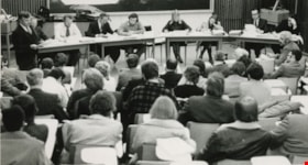
- Photograph of the first set of hearings of the Department of Education task force on change of governing structure for British Columbia Institute of Technology. Students, faculty, and representatives of the B.C. Government Employees' Union are all in the audience, along with Jim Caldwell of forest…
- Repository
- City of Burnaby Archives
- Date
- January 21, 1974
- Collection/Fonds
- Columbian Newspaper collection
- Physical Description
- 1 photograph : b&w ; 10.5 x 19 cm
- Description Level
- Item
- Record No.
- 480-334
- Access Restriction
- No restrictions
- Reproduction Restriction
- Reproduce for fair dealing purposes only
- Accession Number
- 2003-02
- Scope and Content
- Photograph of the first set of hearings of the Department of Education task force on change of governing structure for British Columbia Institute of Technology. Students, faculty, and representatives of the B.C. Government Employees' Union are all in the audience, along with Jim Caldwell of forest resource technology who is standing, reading from a paper. The task force members seated at the front are; Cliff Anderson, Stan Tonoski, Dr. Ralph Patterson, Graham Fane, Dale Michaels, the recording secretary, Cliff McAdam, and Dave Helgeson.
- Subjects
- Government - Provincial Government
- Names
- British Columbia Institute of Technology
- British Columbia Government Employees' Union
- Caldwell, Jim
- Anderson, Cliff
- Tonoski, Stan
- Patterson, Dr. Ralph F.
- Fane, Graham
- Michaels, Dale
- McAdam, Cliff
- Helgeson, Dave
- Media Type
- Photograph
- Photographer
- Battistoni, Peter
- Notes
- Title based on contents of photograph
- Newspaper clipping attached to verso of photograph reads: "BCIT HEARINGS LAUNCHED / It was a sparse to middling crowd Monday night at the first set of hearings into the recommendations of the provincial government's task force on governing BCIT. Students, faculty, and representatives of the B.C. Government Employees' Union look on as Jim Caldwell (far left), of forest resource technology, reads his brief. Task force members are (from left) Cliff Anderson, Stan Tonoski, Dr. Ralph Patterson, Graham Fane, Dale Michaels, Cliff McAdam, and Dave Helgeson."
- Geographic Access
- Willingdon Avenue
- Street Address
- 3700 Willingdon Avenue
- Historic Neighbourhood
- Burnaby Lake (Historic Neighbourhood)
- Planning Study Area
- Douglas-Gilpin Area
Images

Department of Education task force
https://search.heritageburnaby.ca/link/archivedescription45441
- Repository
- City of Burnaby Archives
- Date
- January 21, 1974
- Collection/Fonds
- Columbian Newspaper collection
- Description Level
- Item
- Physical Description
- 1 photograph : b&w ; 10.5 x 19 cm
- Scope and Content
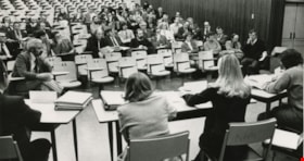
- Photograph of one of the first nights of hearings of the Department of Education task force on change of governing structure for British Columbia Institute of Technology. Students, faculty, and representatives of the B.C. Government Employees' Union are all in the audience, along with Jim Caldwell…
- Repository
- City of Burnaby Archives
- Date
- January 21, 1974
- Collection/Fonds
- Columbian Newspaper collection
- Physical Description
- 1 photograph : b&w ; 10.5 x 19 cm
- Description Level
- Item
- Record No.
- 480-336
- Access Restriction
- No restrictions
- Reproduction Restriction
- Reproduce for fair dealing purposes only
- Accession Number
- 2003-02
- Scope and Content
- Photograph of one of the first nights of hearings of the Department of Education task force on change of governing structure for British Columbia Institute of Technology. Students, faculty, and representatives of the B.C. Government Employees' Union are all in the audience, along with Jim Caldwell of forest resource technology who is seated in the front row of the audience at the far right. The task force members that are visible, with their backs to the camera are; Graham Fane, Dale Michaels, the recording secretary, and Cliff McAdam.
- Subjects
- Government - Provincial Government
- Names
- British Columbia Institute of Technology
- British Columbia Government Employees' Union
- Fane, Graham
- Michaels, Dale
- McAdam, Cliff
- Media Type
- Photograph
- Photographer
- Battistoni, Peter
- Notes
- Title based on contents of photograph
- Geographic Access
- Willingdon Avenue
- Street Address
- 3700 Willingdon Avenue
- Historic Neighbourhood
- Burnaby Lake (Historic Neighbourhood)
- Planning Study Area
- Douglas-Gilpin Area
Images

Commonwealth Parliamentary Conference in Canberra, Australia
https://search.heritageburnaby.ca/link/museumdescription3714
- Repository
- Burnaby Village Museum
- Date
- 1970
- Collection/Fonds
- Harold Edward Winch collection
- Description Level
- Item
- Physical Description
- 1 photograph : b&w ; 16.5 x 22 cm
- Scope and Content
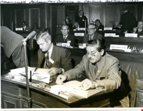
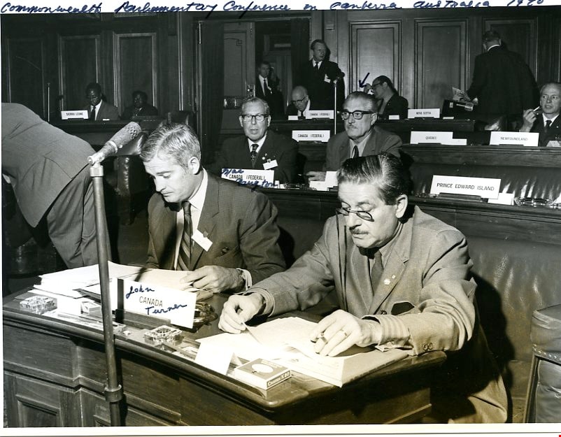
- Item is a photograph of Canadian delegates at the Sixteenth Commonwealth Parliamentary Conference, a meeting of the Commonwealth Parliamentary Association (CPA), held in Canberra, Australia. Identified in the photograph are Harold Winch, John Turner, and Alan Macnaughton.
- Repository
- Burnaby Village Museum
- Collection/Fonds
- Harold Edward Winch collection
- Description Level
- Item
- Physical Description
- 1 photograph : b&w ; 16.5 x 22 cm
- Scope and Content
- Item is a photograph of Canadian delegates at the Sixteenth Commonwealth Parliamentary Conference, a meeting of the Commonwealth Parliamentary Association (CPA), held in Canberra, Australia. Identified in the photograph are Harold Winch, John Turner, and Alan Macnaughton.
- Subjects
- Rights - Human Rights
- Organizations
- Government - Provincial Government
- Government - Federal Government
- Names
- Winch, Harold Edward
- Accession Code
- BV013.12.71
- Date
- 1970
- Media Type
- Photograph
- Related Material
- See photographs BV013.12.61 and BV013.12.78, and textual record BV013.12.82.
- Notes
- Title based on contents of photograph
- Photograph is a part of original scrapbook Item BV013.12.11
Images

Family and political photograph album
https://search.heritageburnaby.ca/link/museumdescription3654
- Repository
- Burnaby Village Museum
- Date
- 1914-1977
- Collection/Fonds
- Harold Edward Winch collection
- Description Level
- Item
- Physical Description
- 1 album (ca. 85 photographs)
- Scope and Content
- Item is a photograph album containing ca. 85 photographs, including both personal and work-related subjects such as the Winch family and homes, and Winch's political work and travels. Also included are some textual records relating to Winch's political work.
- Repository
- Burnaby Village Museum
- Collection/Fonds
- Harold Edward Winch collection
- Description Level
- Item
- Physical Description
- 1 album (ca. 85 photographs)
- Scope and Content
- Item is a photograph album containing ca. 85 photographs, including both personal and work-related subjects such as the Winch family and homes, and Winch's political work and travels. Also included are some textual records relating to Winch's political work.
- Names
- Winch, Harold Edward
- Winch, Linda Marian Hendy
- Winch, Grace
- Winch, Eileen
- Winch, Ernest "Ernie"
- Winch, Eric
- Co-operative Commonwealth Federation "CCF"
- New Democratic Party
- Douglas, Tommy
- MacInnis, Grace
- Accession Code
- BV013.12.11
- Date
- 1914-1977
- Media Type
- Photograph
- Textual Record
- Notes
- Title based on contents of photograph
- A selection of photographs from scrapbook have been described at item level (BV013.12.36 to BV015.35.117)
Images

Documents
![Political photograph album, [193-], 1970-1977 thumbnail](/media/hpo/_Data/_BVM_Images/2013/2013_0012_0012_001.jpg?width=280)
Political photograph album
https://search.heritageburnaby.ca/link/museumdescription3655
- Repository
- Burnaby Village Museum
- Date
- [193-], 1970-1977
- Collection/Fonds
- Harold Edward Winch collection
- Description Level
- Item
- Physical Description
- 1 album (ca. 100 photographs)
- Scope and Content
- Item is a photograph album containing ca. 100 photographs, including primarily work-related subjects such as Winch's political work and travels.
- Repository
- Burnaby Village Museum
- Collection/Fonds
- Harold Edward Winch collection
- Description Level
- Item
- Physical Description
- 1 album (ca. 100 photographs)
- Scope and Content
- Item is a photograph album containing ca. 100 photographs, including primarily work-related subjects such as Winch's political work and travels.
- Names
- Winch, Harold Edward
- MacInnis, Grace
- Winch, Ernest "Ernie"
- Co-operative Commonwealth Federation "CCF"
- New Democratic Party
- Accession Code
- BV013.12.12
- Date
- [193-], 1970-1977
- Media Type
- Photograph
- Textual Record
- Notes
- Title based on contents of photograph
Images
![Political photograph album, [193-], 1970-1977 thumbnail](/media/hpo/_Data/_BVM_Images/2013/2013_0012_0012_001.jpg)
Documents
Simnett political papers series
https://search.heritageburnaby.ca/link/archivedescription82735
- Repository
- City of Burnaby Archives
- Date
- 1956-1998
- Collection/Fonds
- Hazel Simnett collection
- Description Level
- Series
- Physical Description
- 7 files of textual records: ill. (some col.)
- Scope and Content
- Series consists of records related to CFF, Tommy Douglas, the Century Park Museum Association, Burnaby Advisory Planning Commission, NDP, and Elections BC.
- Repository
- City of Burnaby Archives
- Date
- 1956-1998
- Collection/Fonds
- Hazel Simnett collection
- Physical Description
- 7 files of textual records: ill. (some col.)
- Description Level
- Series
- Accession Number
- 2013-22
- Scope and Content
- Series consists of records related to CFF, Tommy Douglas, the Century Park Museum Association, Burnaby Advisory Planning Commission, NDP, and Elections BC.
- Subjects
- Elections
- Officials - Elected Officials
- Government - Local Government
- Government - Provincial Government
- Names
- Simnett, Hazel
- Douglas, Tommy
- Burnaby Advisory Planning Commission
- Co-operative Commonwealth Federation "CCF"
- New Democratic Party
- Media Type
- Textual Record
- Notes
- Title based on contents of series
- Simnett political papers series

Central Park Neighbourhood
https://search.heritageburnaby.ca/link/landmark723
- Repository
- Burnaby Heritage Planning
- Associated Dates
- 1891-1904
- Heritage Value
- Central Park was one of the first and fastest-growing communities in Burnaby. Located along the electric tram line and the Vancouver Road (Kingsway), it was also chosen for a government settlement project referred to as the Central Park Small Holdings. The lands held by the Provincial Government were subdivided and sold around 1894 and by 1899 the settlement was large enough to warrant the construction of an Anglican Church there.
- Historic Neighbourhood
- Central Park (Historic Neighbourhood)
- Planning Study Area
- Maywood Area
Images

10th National Seminar of the Institute of Public Administration of Canada - "Municipal Government in the Governmental Maze"
https://search.heritageburnaby.ca/link/councilreport20826
- Repository
- City of Burnaby Archives
- Report ID
- 13962
- Meeting Date
- 25-Jun-1979
- Format
- Council - Manager's Report
- Manager's Report No.
- 45
- Item No.
- 21
- Collection/Fonds
- City Council and Office of the City Clerk fonds
- Repository
- City of Burnaby Archives
- Report ID
- 13962
- Meeting Date
- 25-Jun-1979
- Format
- Council - Manager's Report
- Manager's Report No.
- 45
- Item No.
- 21
- Collection/Fonds
- City Council and Office of the City Clerk fonds
Documents
#33 Government North Bus Route in Sullivan Heights
https://search.heritageburnaby.ca/link/councilreport25870
- Repository
- City of Burnaby Archives
- Report ID
- 18011
- Meeting Date
- 10-Feb-1975
- Format
- Council - Manager's Report
- Manager's Report No.
- 9
- Item No.
- 20
- Collection/Fonds
- City Council and Office of the City Clerk fonds
- Repository
- City of Burnaby Archives
- Report ID
- 18011
- Meeting Date
- 10-Feb-1975
- Format
- Council - Manager's Report
- Manager's Report No.
- 9
- Item No.
- 20
- Collection/Fonds
- City Council and Office of the City Clerk fonds
Documents
9452 Government Street
https://search.heritageburnaby.ca/link/councilreport29664
- Repository
- City of Burnaby Archives
- Report ID
- 22230
- Meeting Date
- 10-Apr-1972
- Format
- Council - Manager's Report
- Manager's Report No.
- 25
- Item No.
- 6
- Collection/Fonds
- City Council and Office of the City Clerk fonds
- Repository
- City of Burnaby Archives
- Report ID
- 22230
- Meeting Date
- 10-Apr-1972
- Format
- Council - Manager's Report
- Manager's Report No.
- 25
- Item No.
- 6
- Collection/Fonds
- City Council and Office of the City Clerk fonds
Documents
(a) 98 Marine - 99 2nd Street Bus Service (b) No. 33 Government Bus Service
https://search.heritageburnaby.ca/link/councilreport29468
- Repository
- City of Burnaby Archives
- Report ID
- 22425
- Meeting Date
- 26-Jun-1972
- Format
- Council - Manager's Report
- Manager's Report No.
- 42
- Item No.
- 12
- Collection/Fonds
- City Council and Office of the City Clerk fonds
- Repository
- City of Burnaby Archives
- Report ID
- 22425
- Meeting Date
- 26-Jun-1972
- Format
- Council - Manager's Report
- Manager's Report No.
- 42
- Item No.
- 12
- Collection/Fonds
- City Council and Office of the City Clerk fonds
Documents
(a) Brighton Avenue from Lougheed Highway to Winston Street (b) Government Street Eastward (Preliminary Plan Application # 1827)
https://search.heritageburnaby.ca/link/councilreport28989
- Repository
- City of Burnaby Archives
- Report ID
- 22951
- Meeting Date
- 14-Nov-1972
- Format
- Council - Manager's Report
- Manager's Report No.
- 74
- Item No.
- 20
- Collection/Fonds
- City Council and Office of the City Clerk fonds
- Repository
- City of Burnaby Archives
- Report ID
- 22951
- Meeting Date
- 14-Nov-1972
- Format
- Council - Manager's Report
- Manager's Report No.
- 74
- Item No.
- 20
- Collection/Fonds
- City Council and Office of the City Clerk fonds
Documents
Access to Burnaby General Hospital through Provincial Government Lands
https://search.heritageburnaby.ca/link/councilreport21940
- Repository
- City of Burnaby Archives
- Report ID
- 14930
- Meeting Date
- 12-Jun-1978
- Format
- Council - Manager's Report
- Manager's Report No.
- 44
- Item No.
- 13
- Collection/Fonds
- City Council and Office of the City Clerk fonds
- Repository
- City of Burnaby Archives
- Report ID
- 14930
- Meeting Date
- 12-Jun-1978
- Format
- Council - Manager's Report
- Manager's Report No.
- 44
- Item No.
- 13
- Collection/Fonds
- City Council and Office of the City Clerk fonds
Documents
Addition to the statement of lots sold by the provincial government for delinquent taxes
https://search.heritageburnaby.ca/link/councilreport79491
- Repository
- City of Burnaby Archives
- Report ID
- 84004
- Meeting Date
- 26-Jun-1897
- Format
- Council - Mayor/Councillor/Staff Report
- Collection/Fonds
- City Council and Office of the City Clerk fonds
- Repository
- City of Burnaby Archives
- Report ID
- 84004
- Meeting Date
- 26-Jun-1897
- Format
- Council - Mayor/Councillor/Staff Report
- Collection/Fonds
- City Council and Office of the City Clerk fonds
Documents
(a) Government Street (b) Lougheed Highway (c) Scott Street between Greenall Avenue and Boundary Road (d) Willingdon Avenue (e) Halifax-Cliff-Curtis Route
https://search.heritageburnaby.ca/link/councilreport30372
- Repository
- City of Burnaby Archives
- Report ID
- 24310
- Meeting Date
- 13-Sep-1971
- Format
- Council - Committee Report
- Collection/Fonds
- City Council and Office of the City Clerk fonds
- Repository
- City of Burnaby Archives
- Report ID
- 24310
- Meeting Date
- 13-Sep-1971
- Format
- Council - Committee Report
- Collection/Fonds
- City Council and Office of the City Clerk fonds
Documents
(a) Lot 78, DL's 2 and 6, Plan 35966 (Proposed Crown Zellerbach Home Centre) (b) Government Place
https://search.heritageburnaby.ca/link/councilreport29251
- Repository
- City of Burnaby Archives
- Report ID
- 22640
- Meeting Date
- 28-Aug-1972
- Format
- Council - Manager's Report
- Manager's Report No.
- 52
- Item No.
- 28
- Collection/Fonds
- City Council and Office of the City Clerk fonds
- Repository
- City of Burnaby Archives
- Report ID
- 22640
- Meeting Date
- 28-Aug-1972
- Format
- Council - Manager's Report
- Manager's Report No.
- 52
- Item No.
- 28
- Collection/Fonds
- City Council and Office of the City Clerk fonds