Narrow Results By
Decade
- 2020s 11
- 2010s 4
- 2000s 106
- 1990s 88
- 1980s 22
- 1970s 305
- 1960s 73
- 1950s 82
- 1940s 60
- 1930s 53
- 1920s 88
- 1910s 65
- 1900s 24
- 1890s 10
- 1880s 2
- 1870s 1
- 1860s 2
- 1850s 1
- 1840s 1
- 1830s 1
- 1820s 1
- 1810s 1
- 1800s 1
- 1790s 1
- 1780s 1
- 1770s 1
- 1760s 1
- 1750s 1
- 1740s 1
- 1730s 1
- 1720s 1
- 1710s 1
- 1700s 1
- 1690s 1
- 1680s 1
- 1670s 1
- 1660s 1
- 1650s 1
- 1640s 1
- 1630s 1
- 1620s 1
- 1610s 1
- 1600s 1
Subject
- Advertising Medium 1
- Advertising Medium - Signs and Signboards 4
- Aerial Photographs 7
- Agricultural Tools and Equipment 5
- Agricultural Tools and Equipment - Plows 3
- Agriculture 1
- Agriculture - Crops 3
- Agriculture - Farms 21
- Agriculture - Fruit and Berries 1
- Agriculture - Ranches 1
- Animals - Cats 1
- Animals - Cows 1

20th century typewriting : complete course
https://search.heritageburnaby.ca/link/museumlibrary5012
- Repository
- Burnaby Village Museum
- Collection
- Special Collection
- Material Type
- Book
- Accession Code
- BV007.2.1
- Call Number
- 652.3 LES
- Edition
- 6th ed.
- Place of Publication
- Cincinnati
- Publisher
- South-Western Publishing Co.
- Publication Date
- c1952
- Physical Description
- 340 p. : ill. : 20 x 28 cm.
- Library Subject (LOC)
- Typewriting
- Subjects
- Documentary Artifacts - Books
- Historic Neighbourhood
- Edmonds (Historic Neighbourhood)
- Burnaby Lake (Historic Neighbourhood)
- Planning Study Area
- Kingsway-Beresford Area
- Douglas-Gilpin Area
- Geographic Access
- Canada Way
- Southoaks Crescent
- Street Address
- 4939 Canada Way
- 6650 Southoaks Crescent
- Object History
- Was used by Burnaby resident Barbara Copan when she taught typing at Burnaby Central circa 1963-65. It may have originally belonged to Barbara's mother who also taught typing at Burnaby South High School circa 1957 to 1965. She mainly taught typing in night school.
- Notes
- Authors' given name and date as follows: Lessenberry, D.D. (David Daniel), 1896- Crawford, T. James (Thomas James)
Images


3000, 3100, 3200 Beta Ave
https://search.heritageburnaby.ca/link/archivedescription93739
- Repository
- City of Burnaby Archives
- Date
- 1989
- Collection/Fonds
- Grover, Elliott & Co. Ltd. fonds
- Description Level
- File
- Physical Description
- 40 photographs : col. negatives ; 35 mm
- Scope and Content
- Photographs of the commercial buildings and loading bays located at 3000, 3100, and 3200 Beta Avenue.
- Repository
- City of Burnaby Archives
- Date
- 1989
- Collection/Fonds
- Grover, Elliott & Co. Ltd. fonds
- Physical Description
- 40 photographs : col. negatives ; 35 mm
- Description Level
- File
- Record No.
- 622-024
- Access Restriction
- No restrictions
- Reproduction Restriction
- No restrictions
- Accession Number
- 2017-39
- Scope and Content
- Photographs of the commercial buildings and loading bays located at 3000, 3100, and 3200 Beta Avenue.
- Subjects
- Buildings - Commercial
- Media Type
- Photograph
- Notes
- Transcribed title
- Title transcribed from print envelope photographs were originally housed in
- File no. 89-214-B
- Geographic Access
- Beta Avenue
- Street Address
- 3000 Beta Avenue
- 3100 Beta Avenue
- 3200 Beta Avenue
- Planning Study Area
- Douglas-Gilpin Area
3000, 3100, and 3200 Beta Ave
https://search.heritageburnaby.ca/link/archivedescription93757
- Repository
- City of Burnaby Archives
- Date
- May 5, 1992
- Collection/Fonds
- Grover, Elliott & Co. Ltd. fonds
- Description Level
- File
- Physical Description
- 46 photographs : col. negatives ; 35 mm
- Scope and Content
- Photographs of the commercial buildings located at 3000, 3100, and 3200 Beta Avenue.
- Repository
- City of Burnaby Archives
- Date
- May 5, 1992
- Collection/Fonds
- Grover, Elliott & Co. Ltd. fonds
- Physical Description
- 46 photographs : col. negatives ; 35 mm
- Description Level
- File
- Record No.
- 622-042
- Access Restriction
- No restrictions
- Reproduction Restriction
- No restrictions
- Accession Number
- 2017-39
- Scope and Content
- Photographs of the commercial buildings located at 3000, 3100, and 3200 Beta Avenue.
- Subjects
- Buildings - Commercial
- Media Type
- Photograph
- Photographer
- Young, Richard
- Notes
- Transcribed title
- Title transcribed from envelope photographs were originally housed in
- File no. 92-183-B
- Geographic Access
- Beta Avenue
- Street Address
- 3000 Beta Avenue
- 3100 Beta Avenue
- 3200 Beta Avenue
- Planning Study Area
- Douglas-Gilpin Area
3000-3200 Beta Ave
https://search.heritageburnaby.ca/link/archivedescription93888
- Repository
- City of Burnaby Archives
- Date
- April 1993
- Collection/Fonds
- Grover, Elliott & Co. Ltd. fonds
- Description Level
- File
- Physical Description
- 46 photographs : col. negatives ; 35 mm
- Scope and Content
- Photographs of the exteriors of the commercial buildings located at 3000-3200 Beta Avenue.
- Repository
- City of Burnaby Archives
- Date
- April 1993
- Collection/Fonds
- Grover, Elliott & Co. Ltd. fonds
- Physical Description
- 46 photographs : col. negatives ; 35 mm
- Description Level
- File
- Record No.
- 622-071
- Access Restriction
- No restrictions
- Reproduction Restriction
- No restrictions
- Accession Number
- 2017-39
- Scope and Content
- Photographs of the exteriors of the commercial buildings located at 3000-3200 Beta Avenue.
- Subjects
- Buildings - Commercial
- Media Type
- Photograph
- Photographer
- Young, Richard
- Notes
- Transcribed title
- Title transcribed from envelope photographs were originally housed in
- File no. 93-192-B
- Geographic Access
- Beta Avenue
- Street Address
- 3000 Beta Avenue
- 3100 Beta Avenue
- 3200 Beta Avenue
- Planning Study Area
- Douglas-Gilpin Area
![4006 Douglas Road, [1960] (date of original), copied 1991 thumbnail](/media/hpo/_Data/_Archives_Images/_Unrestricted/370/370-516.jpg?width=280)
4006 Douglas Road
https://search.heritageburnaby.ca/link/archivedescription37928
- Repository
- City of Burnaby Archives
- Date
- [1960] (date of original), copied 1991
- Collection/Fonds
- Burnaby Historical Society fonds
- Description Level
- Item
- Physical Description
- 1 photograph : b&w ; 3.1 x 3.1 cm print on contact sheet 20.7 x 26.5 cm
- Scope and Content
- Photograph of 4006 Douglas Road (old numbering) in the snow. The house was located near Douglas Road and Gilpin Street.
- Repository
- City of Burnaby Archives
- Date
- [1960] (date of original), copied 1991
- Collection/Fonds
- Burnaby Historical Society fonds
- Subseries
- Burnaby Image Bank subseries
- Physical Description
- 1 photograph : b&w ; 3.1 x 3.1 cm print on contact sheet 20.7 x 26.5 cm
- Description Level
- Item
- Record No.
- 370-516
- Access Restriction
- No restrictions
- Reproduction Restriction
- No restrictions
- Accession Number
- BHS1999-03
- Scope and Content
- Photograph of 4006 Douglas Road (old numbering) in the snow. The house was located near Douglas Road and Gilpin Street.
- Subjects
- Natural Phenomena - Snow
- Media Type
- Photograph
- Notes
- Title based on contents of photograph
- 1 b&w copy negative accompanying
- Negative has a pink cast
- Geographic Access
- Gilpin Street
- Historic Neighbourhood
- Burnaby Lake (Historic Neighbourhood)
- Planning Study Area
- Douglas-Gilpin Area
Images
![4006 Douglas Road, [1960] (date of original), copied 1991 thumbnail](/media/hpo/_Data/_Archives_Images/_Unrestricted/370/370-516.jpg)
5190 Norfolk St
https://search.heritageburnaby.ca/link/archivedescription93756
- Repository
- City of Burnaby Archives
- Date
- April 14, 1992
- Collection/Fonds
- Grover, Elliott & Co. Ltd. fonds
- Description Level
- File
- Physical Description
- 25 photographs : col. negatives ; 35 mm
- Scope and Content
- Photographs of the exterior of the Royal Oak Baptist Church located at 5190 Norfolk Street.
- Repository
- City of Burnaby Archives
- Date
- April 14, 1992
- Collection/Fonds
- Grover, Elliott & Co. Ltd. fonds
- Physical Description
- 25 photographs : col. negatives ; 35 mm
- Description Level
- File
- Record No.
- 622-041
- Access Restriction
- No restrictions
- Reproduction Restriction
- No restrictions
- Accession Number
- 2017-39
- Scope and Content
- Photographs of the exterior of the Royal Oak Baptist Church located at 5190 Norfolk Street.
- Subjects
- Buildings - Religious - Churches
- Media Type
- Photograph
- Photographer
- Young, Richard
- Notes
- Transcribed title
- Title transcribed from envelope photographs were originally housed in
- File no. 92-167-B
- Geographic Access
- Norfolk Street
- Street Address
- 5190 Norfolk Street
- Planning Study Area
- Douglas-Gilpin Area
![Aaron Lau throwing a javelin, [1999] thumbnail](/media/hpo/_Data/_Archives_Images/_Unrestricted/535/535-3160.jpg?width=280)
Aaron Lau throwing a javelin
https://search.heritageburnaby.ca/link/archivedescription98080
- Repository
- City of Burnaby Archives
- Date
- [1999]
- Collection/Fonds
- Burnaby NewsLeader photograph collection
- Description Level
- Item
- Physical Description
- 1 photograph (tiff) : col.
- Scope and Content
- Photograph of Aaron Lau, a Moscrop Secondary School student, about to throw a javelin during a Burnaby-New Westminster high school track and field meet at Burnaby Central.
- Repository
- City of Burnaby Archives
- Date
- [1999]
- Collection/Fonds
- Burnaby NewsLeader photograph collection
- Physical Description
- 1 photograph (tiff) : col.
- Description Level
- Item
- Record No.
- 535-3160
- Access Restriction
- No restrictions
- Reproduction Restriction
- No restrictions
- Accession Number
- 2018-12
- Scope and Content
- Photograph of Aaron Lau, a Moscrop Secondary School student, about to throw a javelin during a Burnaby-New Westminster high school track and field meet at Burnaby Central.
- Subjects
- Sports
- Persons - Students
- Media Type
- Photograph
- Notes
- Title based on caption
- Collected by editorial for use in a May 1999 issue of the Burnaby NewsLeader
- Caption from metadata: "Moscrop's Aaron Lau rears back in the boys' javelin competition at the Burnaby-New West high school track and field meet at Burnaby Central."
- Geographic Access
- Canada Way
- Street Address
- 4939 Canada Way
- Historic Neighbourhood
- Burnaby Lake (Historic Neighbourhood)
- Planning Study Area
- Douglas-Gilpin Area
Images
![Aaron Lau throwing a javelin, [1999] thumbnail](/media/hpo/_Data/_Archives_Images/_Unrestricted/535/535-3160.jpg)

Adults and children at Deer Lake Park
https://search.heritageburnaby.ca/link/archivedescription59007
- Repository
- City of Burnaby Archives
- Date
- ca.1983
- Collection/Fonds
- Columbian Newspaper collection
- Description Level
- Item
- Physical Description
- 1 photograph : b&w ; 20.5 x 25.5 cm
- Scope and Content
- Photograph of adults and children having a picnic on the beach at Deer Lake Park.
- Repository
- City of Burnaby Archives
- Date
- ca.1983
- Collection/Fonds
- Columbian Newspaper collection
- Physical Description
- 1 photograph : b&w ; 20.5 x 25.5 cm
- Description Level
- Item
- Record No.
- 480-1416
- Access Restriction
- No restrictions
- Reproduction Restriction
- Reproduce for fair dealing purposes only
- Accession Number
- 2009-01
- Scope and Content
- Photograph of adults and children having a picnic on the beach at Deer Lake Park.
- Subjects
- Recreational Activities - Picnics
- Geographic Features - Lakes and Ponds
- Geographic Features - Beaches
- Persons - Children
- Media Type
- Photograph
- Photographer
- King, Basil
- Notes
- Title based on contents of photograph
- Photographer's stamp on verso
- Note on verso reads: "PMT 120% / page 10 / Burnaby / Today"
- Geographic Access
- Deer Lake Park
- Historic Neighbourhood
- Burnaby Lake (Historic Neighbourhood)
- Planning Study Area
- Douglas-Gilpin Area
Images

Aerial photograph of Burnaby
https://search.heritageburnaby.ca/link/archivedescription84903
- Repository
- City of Burnaby Archives
- Date
- 1963
- Collection/Fonds
- Allan Amundsen collection
- Description Level
- Item
- Physical Description
- 1 photograph : b&w ; 22.5 x 22.5 cm
- Scope and Content
- Aerial photograph of Burnaby with the Trans Canada Highway running through and the Forest Lawn Cemetery to the south.
- Repository
- City of Burnaby Archives
- Date
- 1963
- Collection/Fonds
- Allan Amundsen collection
- Physical Description
- 1 photograph : b&w ; 22.5 x 22.5 cm
- Description Level
- Item
- Record No.
- 561-024
- Access Restriction
- In Archives only
- Reproduction Restriction
- No reproduction permitted
- Accession Number
- 2014-08
- Scope and Content
- Aerial photograph of Burnaby with the Trans Canada Highway running through and the Forest Lawn Cemetery to the south.
- Subjects
- Aerial Photographs
- Media Type
- Photograph
- Photographer
- Province of British Columbia
- Notes
- Title based on contents of photograph
- This photo is indentified as BC5062:27 and connects with B.C. air photograph BC5061:26 to the east
- Historic Neighbourhood
- Burnaby Lake (Historic Neighbourhood)
- Planning Study Area
- Douglas-Gilpin Area
- Ardingley-Sprott Area
- Dawson-Delta Area
Aerial photograph of Burnaby
https://search.heritageburnaby.ca/link/archivedescription84907
- Repository
- City of Burnaby Archives
- Date
- 1963
- Collection/Fonds
- Allan Amundsen collection
- Description Level
- Item
- Physical Description
- 1 photograph : b&w ; 22.5 x 22.5 cm
- Scope and Content
- Aerial photograph of Burnaby with the Trans Canada Highway running from through and Burnaby Lake in the south east corner.
- Repository
- City of Burnaby Archives
- Date
- 1963
- Collection/Fonds
- Allan Amundsen collection
- Physical Description
- 1 photograph : b&w ; 22.5 x 22.5 cm
- Description Level
- Item
- Record No.
- 561-025
- Access Restriction
- In Archives only
- Reproduction Restriction
- No reproduction permitted
- Accession Number
- 2014-08
- Scope and Content
- Aerial photograph of Burnaby with the Trans Canada Highway running from through and Burnaby Lake in the south east corner.
- Subjects
- Aerial Photographs
- Media Type
- Photograph
- Photographer
- Province of British Columbia
- Notes
- Title based on contents of photograph
- This photo is indentified as BC5062:26 and connects with B.C. air photograph BC5062:27 to the west and B.C. air photograph BC5062:25 to the east
- Historic Neighbourhood
- Burnaby Lake (Historic Neighbourhood)
- Planning Study Area
- Douglas-Gilpin Area
- Ardingley-Sprott Area
- Burnaby Lake Area
Aerial photograph of Burnaby Lake Area
https://search.heritageburnaby.ca/link/archivedescription84908
- Repository
- City of Burnaby Archives
- Date
- 1963
- Collection/Fonds
- Allan Amundsen collection
- Description Level
- Item
- Physical Description
- 1 photograph : b&w ; 22.5 x 22.5 cm
- Scope and Content
- Aerial photograph of Burnaby with Lougheed Highway in the north west corner, the Trans Canada Highway in the south east corner and Burnaby Lake appearing from the west.
- Repository
- City of Burnaby Archives
- Date
- 1963
- Collection/Fonds
- Allan Amundsen collection
- Physical Description
- 1 photograph : b&w ; 22.5 x 22.5 cm
- Description Level
- Item
- Record No.
- 561-026
- Access Restriction
- In Archives only
- Reproduction Restriction
- No reproduction permitted
- Accession Number
- 2014-08
- Scope and Content
- Aerial photograph of Burnaby with Lougheed Highway in the north west corner, the Trans Canada Highway in the south east corner and Burnaby Lake appearing from the west.
- Subjects
- Aerial Photographs
- Media Type
- Photograph
- Photographer
- Province of British Columbia
- Notes
- Title based on contents of photograph
- This photo is indentified as BC5062:25 and connects with B.C. air photograph BC5062:26 to the west and B.C. air photograph BC5062:24 to the east
- Historic Neighbourhood
- Burnaby Lake (Historic Neighbourhood)
- Lozells (Historic Neighbourhood)
- Planning Study Area
- Douglas-Gilpin Area
- Sperling-Broadway Area
- Government Road Area
- Burnaby Lake Area
Aerial photograph of Burnaby Lake Area
https://search.heritageburnaby.ca/link/archivedescription84909
- Repository
- City of Burnaby Archives
- Date
- 1963
- Collection/Fonds
- Allan Amundsen collection
- Description Level
- Item
- Physical Description
- 1 photograph : b&w ; 22.5 x 22.5 cm
- Scope and Content
- Aerial photograph of Burnaby with Lougheed Highway to the north and Burnaby Lake to the south.
- Repository
- City of Burnaby Archives
- Date
- 1963
- Collection/Fonds
- Allan Amundsen collection
- Physical Description
- 1 photograph : b&w ; 22.5 x 22.5 cm
- Description Level
- Item
- Record No.
- 561-027
- Access Restriction
- In Archives only
- Reproduction Restriction
- No reproduction permitted
- Accession Number
- 2014-08
- Scope and Content
- Aerial photograph of Burnaby with Lougheed Highway to the north and Burnaby Lake to the south.
- Subjects
- Aerial Photographs
- Media Type
- Photograph
- Photographer
- Province of British Columbia
- Notes
- Title based on contents of photograph
- This photo is indentified as BC5062:24 and connects with B.C. air photograph BC5062:25 to the west and B.C. air photograph BC5062:23 to the east
- Historic Neighbourhood
- Burnaby Lake (Historic Neighbourhood)
- Lozells (Historic Neighbourhood)
- Planning Study Area
- Douglas-Gilpin Area
- Sperling-Broadway Area
- Government Road Area
- Burnaby Lake Area
![Aerial spraying over Burnaby Lake, [2000] thumbnail](/media/hpo/_Data/_Archives_Images/_Unrestricted/535/535-2408.jpg?width=280)
Aerial spraying over Burnaby Lake
https://search.heritageburnaby.ca/link/archivedescription96850
- Repository
- City of Burnaby Archives
- Date
- [2000]
- Collection/Fonds
- Burnaby NewsLeader photograph collection
- Description Level
- Item
- Physical Description
- 1 photograph (tiff) : b&w
- Scope and Content
- Photograph of an airplane spraying pesticides over Burnaby Lake to eradicate European Gypsy moths.
- Repository
- City of Burnaby Archives
- Date
- [2000]
- Collection/Fonds
- Burnaby NewsLeader photograph collection
- Physical Description
- 1 photograph (tiff) : b&w
- Description Level
- Item
- Record No.
- 535-2408
- Access Restriction
- No restrictions
- Reproduction Restriction
- No restrictions
- Accession Number
- 2018-12
- Scope and Content
- Photograph of an airplane spraying pesticides over Burnaby Lake to eradicate European Gypsy moths.
- Media Type
- Photograph
- Notes
- Title based on original file name
- Collected by editorial for use in a May 2000 issue of the Burnaby NewsLeader
- Geographic Access
- Burnaby Lake
- Historic Neighbourhood
- Burnaby Lake (Historic Neighbourhood)
- Planning Study Area
- Douglas-Gilpin Area
Images
![Aerial spraying over Burnaby Lake, [2000] thumbnail](/media/hpo/_Data/_Archives_Images/_Unrestricted/535/535-2408.jpg)

Aerial view from Central Park
https://search.heritageburnaby.ca/link/archivedescription78855
- Repository
- City of Burnaby Archives
- Date
- September 27, 1976
- Collection/Fonds
- Burnaby Public Library Contemporary Visual Archive Project
- Description Level
- Item
- Physical Description
- 1 photograph : b&w ; 11 x 16 cm mounted on cardboard
- Scope and Content
- Photograph is an aerial view looking northeast from Central Park with Forest Lawn Memorial Park and Deer Lake in the background.
- Repository
- City of Burnaby Archives
- Date
- September 27, 1976
- Collection/Fonds
- Burnaby Public Library Contemporary Visual Archive Project
- Physical Description
- 1 photograph : b&w ; 11 x 16 cm mounted on cardboard
- Description Level
- Item
- Record No.
- 556-003
- Access Restriction
- No restrictions
- Reproduction Restriction
- Reproduce for fair dealing purposes only
- Accession Number
- 2013-13
- Scope and Content
- Photograph is an aerial view looking northeast from Central Park with Forest Lawn Memorial Park and Deer Lake in the background.
- Subjects
- Aerial Photographs
- Media Type
- Photograph
- Photographer
- Norton, Paul
- Notes
- Scope note taken directly from BPL photograph description.
- 1 b&w copy negative : 10 x 12.5 cm accompanying
- Planning Study Area
- Windsor Area
- Douglas-Gilpin Area
Images


Agnes Pender
https://search.heritageburnaby.ca/link/archivedescription78677
- Repository
- City of Burnaby Archives
- Date
- November 5, 1995
- Collection/Fonds
- Burnaby NewsLeader photograph collection
- Description Level
- Item
- Physical Description
- 1 photograph : b&w ; 16 x 24 cm
- Scope and Content
- Photograph of Agnes Pender at Burnaby City Hall where her painting was stolen from the front lobby wall.
- Repository
- City of Burnaby Archives
- Date
- November 5, 1995
- Collection/Fonds
- Burnaby NewsLeader photograph collection
- Physical Description
- 1 photograph : b&w ; 16 x 24 cm
- Description Level
- Item
- Record No.
- 535-0038
- Access Restriction
- No restrictions
- Reproduction Restriction
- No reproduction permitted
- Accession Number
- 2012-11
- Scope and Content
- Photograph of Agnes Pender at Burnaby City Hall where her painting was stolen from the front lobby wall.
- Subjects
- Occupations - Artists
- Media Type
- Photograph
- Photographer
- Bartel, Mario
- Notes
- Title based on contents of photograph
- Note in black and blue ink on recto of photograph reads: "Bartel Bby 3035 / 100% Bby 3"
- Trim marks and/or reproduction instructions on recto (scan is cropped)
- Geographic Access
- Canada Way
- Street Address
- 4949 Canada Way
- Historic Neighbourhood
- Burnaby Lake (Historic Neighbourhood)
- Planning Study Area
- Douglas-Gilpin Area
Images

![Albert and Elsie Dawkins, [1923] (date of original), copied 1991 thumbnail](/media/hpo/_Data/_Archives_Images/_Unrestricted/370/370-276.jpg?width=280)
Albert and Elsie Dawkins
https://search.heritageburnaby.ca/link/archivedescription37688
- Repository
- City of Burnaby Archives
- Date
- [1923] (date of original), copied 1991
- Collection/Fonds
- Burnaby Historical Society fonds
- Description Level
- Item
- Physical Description
- 1 photograph : b&w ; 2.9 x 5.0 cm print on contact sheet 20.2 x 25.3 cm
- Scope and Content
- Photograph of siblings Albert Dawkins (age 9) and Elsie Dawkins (age 5) at their Balfour Avenue home (later renamed Atlee Avenue). Albert is holding a cat, and Elsie is standing beside a dog.
- Repository
- City of Burnaby Archives
- Date
- [1923] (date of original), copied 1991
- Collection/Fonds
- Burnaby Historical Society fonds
- Subseries
- Burnaby Image Bank subseries
- Physical Description
- 1 photograph : b&w ; 2.9 x 5.0 cm print on contact sheet 20.2 x 25.3 cm
- Description Level
- Item
- Record No.
- 370-276
- Access Restriction
- No restrictions
- Reproduction Restriction
- No known restrictions
- Accession Number
- BHS1999-03
- Scope and Content
- Photograph of siblings Albert Dawkins (age 9) and Elsie Dawkins (age 5) at their Balfour Avenue home (later renamed Atlee Avenue). Albert is holding a cat, and Elsie is standing beside a dog.
- Subjects
- Animals - Cats
- Animals - Dogs
- Media Type
- Photograph
- Notes
- Title based on contents of photograph
- 1 b&w copy negative accompanying
- Negative has a pink cast
- Geographic Access
- Atlee Avenue
- Historic Neighbourhood
- Burnaby Lake (Historic Neighbourhood)
- Planning Study Area
- Douglas-Gilpin Area
Images
![Albert and Elsie Dawkins, [1923] (date of original), copied 1991 thumbnail](/media/hpo/_Data/_Archives_Images/_Unrestricted/370/370-276.jpg)
![Alf Vickson in Burnaby Central Secondary School, [2001] thumbnail](/media/hpo/_Data/_Archives_Images/_Unrestricted/535/535-2732.jpg?width=280)
Alf Vickson in Burnaby Central Secondary School
https://search.heritageburnaby.ca/link/archivedescription97342
- Repository
- City of Burnaby Archives
- Date
- [2001]
- Collection/Fonds
- Burnaby NewsLeader photograph collection
- Description Level
- Item
- Physical Description
- 1 photograph (tiff) : col.
- Scope and Content
- Photograph of custodian Alf Vickson unscrewing an "exit" sign at Burnaby Central Secondary School after renovations and before the school's reopening for the fall.
- Repository
- City of Burnaby Archives
- Date
- [2001]
- Collection/Fonds
- Burnaby NewsLeader photograph collection
- Physical Description
- 1 photograph (tiff) : col.
- Description Level
- Item
- Record No.
- 535-2732
- Access Restriction
- No restrictions
- Reproduction Restriction
- No restrictions
- Accession Number
- 2018-12
- Scope and Content
- Photograph of custodian Alf Vickson unscrewing an "exit" sign at Burnaby Central Secondary School after renovations and before the school's reopening for the fall.
- Subjects
- Buildings - Schools
- Media Type
- Photograph
- Photographer
- Bartel, Mario
- Notes
- Title based on caption
- Collected by editorial for use in a September 2001 issue of the Burnaby NewsLeader
- Caption from metadata: "Alf Vickson, a custodian at Burnaby Central Secondary, removes an emergency exit sign to replace a burned out light bulb. Most of the major renovation work, floor buffing and painting are done at the school, leaving just the smaller, routine jobs to be completed in the last hectic days before the school reopens for the Fall semester."
- Geographic Access
- Canada Way
- Street Address
- 4939 Canada Way
- Historic Neighbourhood
- Burnaby Lake (Historic Neighbourhood)
- Planning Study Area
- Douglas-Gilpin Area
Images
![Alf Vickson in Burnaby Central Secondary School, [2001] thumbnail](/media/hpo/_Data/_Archives_Images/_Unrestricted/535/535-2732.jpg)
![Allan Rock at BCIT campaign event, [2000] thumbnail](/media/hpo/_Data/_Archives_Images/_Unrestricted/535/535-1684-1.jpg?width=280)
Allan Rock at BCIT campaign event
https://search.heritageburnaby.ca/link/archivedescription95884
- Repository
- City of Burnaby Archives
- Date
- [2000]
- Collection/Fonds
- Burnaby NewsLeader photograph collection
- Description Level
- File
- Physical Description
- 3 photographs (tiff) : col.
- Scope and Content
- File contains photographs of Federal Health Minister Allan Rock speaking with nursing students during a campaign event at BCIT. Photographs show close-ups of Rock and one of the nursing students asking a question, as well as a photograph of Rock speaking as attendees look on in the background.
- Repository
- City of Burnaby Archives
- Date
- [2000]
- Collection/Fonds
- Burnaby NewsLeader photograph collection
- Physical Description
- 3 photographs (tiff) : col.
- Description Level
- File
- Record No.
- 535-1684
- Access Restriction
- No restrictions
- Reproduction Restriction
- No restrictions
- Accession Number
- 2018-12
- Scope and Content
- File contains photographs of Federal Health Minister Allan Rock speaking with nursing students during a campaign event at BCIT. Photographs show close-ups of Rock and one of the nursing students asking a question, as well as a photograph of Rock speaking as attendees look on in the background.
- Subjects
- Elections
- Officials - Elected Officials
- Media Type
- Photograph
- Photographer
- Bartel, Mario
- Notes
- Title based on caption
- Collected by editorial for use in a November 2000 issue of the Burnaby NewsLeader
- Caption from metadata for 535-1684-1: "Federal Health Minister Allan Rock speaks with nursing students during a campaign stop at BCIT."
- Caption from metadata for 535-1684-2: "Federal Health Minister Allan Rock addresses nursing students at BCIT, during an election campaign stop."
- Caption from metadata for 535-1684-3: "Michelle Marisi, a nurse at Vancouver General, studying critical care, raises her concerns with federal Health Minister, Allan Rock."
- Geographic Access
- Willingdon Avenue
- Street Address
- 3700 Willingdon Avenue
- Planning Study Area
- Douglas-Gilpin Area
Images
![Allan Rock at BCIT campaign event, [2000] thumbnail](/media/hpo/_Data/_Archives_Images/_Unrestricted/535/535-1684-1.jpg)
![Alpha Secondary basketball game, [2004] thumbnail](/media/hpo/_Data/_Archives_Images/_Unrestricted/535/535-1788-1.jpg?width=280)
Alpha Secondary basketball game
https://search.heritageburnaby.ca/link/archivedescription96039
- Repository
- City of Burnaby Archives
- Date
- [2004]
- Collection/Fonds
- Burnaby NewsLeader photograph collection
- Description Level
- File
- Physical Description
- 2 photographs (tiff) : col.
- Scope and Content
- File contains photographs of a basketball game between Alpha Secondary School and West Vancouver during the Crehan Cup Lower Mainland Girls AAA Basketball Championship at Burnaby Central Secondary School.
- Repository
- City of Burnaby Archives
- Date
- [2004]
- Collection/Fonds
- Burnaby NewsLeader photograph collection
- Physical Description
- 2 photographs (tiff) : col.
- Description Level
- File
- Record No.
- 535-1788
- Access Restriction
- No restrictions
- Reproduction Restriction
- No restrictions
- Accession Number
- 2018-12
- Scope and Content
- File contains photographs of a basketball game between Alpha Secondary School and West Vancouver during the Crehan Cup Lower Mainland Girls AAA Basketball Championship at Burnaby Central Secondary School.
- Subjects
- Sports - Basketball
- Persons - Students
- Names
- Alpha Secondary School
- Media Type
- Photograph
- Photographer
- Bartel, Mario
- Notes
- Title based on caption
- Collected by editorial for use in a February 2004 issue of the Burnaby NewsLeader
- Caption from metadata for 535-1788-1: "Alpha Aztecs' forward Alyssa Agostini drives past a West Vancouver defender in their first round game at the Crehan Cup, for the Lower Mainland Girls AAA Basketball Championship, Saturday at Burnaby Central."
- Caption from metadata for 535-1788-2: "Alpha Aztecs' guard Vicky Yee tries to work around West Vancouver's Brea McLaughlin, in their first round game of the Crehan Cup, for the 2004 Lower Mainland Girls' AAA Basketball Championship, Saturday at Burnaby Central."
- Geographic Access
- Canada Way
- Street Address
- 4939 Canada Way
- Historic Neighbourhood
- Burnaby Lake (Historic Neighbourhood)
- Planning Study Area
- Douglas-Gilpin Area
Images
![Alpha Secondary basketball game, [2004] thumbnail](/media/hpo/_Data/_Archives_Images/_Unrestricted/535/535-1788-1.jpg)
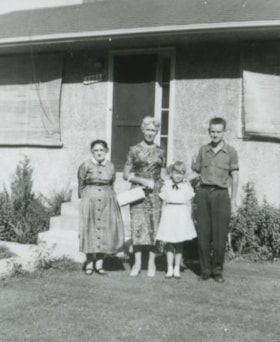
Anderson family
https://search.heritageburnaby.ca/link/archivedescription37440
- Repository
- City of Burnaby Archives
- Date
- 1958 (date of original), copied 1991
- Collection/Fonds
- Burnaby Historical Society fonds
- Description Level
- Item
- Physical Description
- 1 photograph : b&w ; 4.2 x 3.5 cm print on contact sheet 20.2 x 25.3 cm
- Scope and Content
- Photograph of the Anderson family in front of the Anderson family home at 3908 Norland Avenue (previously numbered 4437 Norland Avenue). Left to right: Mrs. Anderson (grandmother), Madelaine Anderson (mother), Janet Anderson (daughter), and Cliff Anderson (son).
- Repository
- City of Burnaby Archives
- Date
- 1958 (date of original), copied 1991
- Collection/Fonds
- Burnaby Historical Society fonds
- Subseries
- Burnaby Image Bank subseries
- Physical Description
- 1 photograph : b&w ; 4.2 x 3.5 cm print on contact sheet 20.2 x 25.3 cm
- Description Level
- Item
- Record No.
- 370-028
- Access Restriction
- No restrictions
- Reproduction Restriction
- No restrictions
- Accession Number
- BHS1999-03
- Scope and Content
- Photograph of the Anderson family in front of the Anderson family home at 3908 Norland Avenue (previously numbered 4437 Norland Avenue). Left to right: Mrs. Anderson (grandmother), Madelaine Anderson (mother), Janet Anderson (daughter), and Cliff Anderson (son).
- Media Type
- Photograph
- Notes
- Title based on contents of photograph
- 1 b&w copy negative accompanying
- Geographic Access
- Norland Avenue
- Street Address
- 3908 Norland Avenue
- Historic Neighbourhood
- Burnaby Lake (Historic Neighbourhood)
- Planning Study Area
- Douglas-Gilpin Area
Images
