Narrow Results By
Subject
- Agricultural Tools and Equipment 1
- Agriculture - Fruit and Berries 1
- Construction Tools and Equipment 1
- Container - Box 1
- Natural Phenomena - Snow 2
- Sound Communication Tools and Equipment 1
- Transportation 1
- Transportation - Electric Railroads 1
- Wars - World War, 1939-1945 1
- Woodworking Tools and Equipment 1
Person / Organization
- Andrusiak, Margaret Martin Greenall 6
- British Columbia Electric Railway Company 1
- Forbes, Sally Martin 3
- Martin, Dr. Bill 5
- Martin, Dr. Jackie 7
- Martin, Ellen Ward 2
- Martin, William 1
- Philips, Adell Greenwood 1
- Punnett, Barbara Martin 5
- Safarik, Juanita "Nita" Martin 7
- Sanders, Eileen 1
- Sanders, Gerald Frank 2
Request to Amend a Covenant Restricting Development of the Site - 5510 Spruce Street
https://search.heritageburnaby.ca/link/councilreport1946
- Repository
- City of Burnaby Archives
- Report ID
- 65208
- Meeting Date
- 22-Mar-2004
- Format
- Council - Manager's Report
- Manager's Report No.
- 9
- Item No.
- 10
- Collection/Fonds
- City Council and Office of the City Clerk fonds
- Repository
- City of Burnaby Archives
- Report ID
- 65208
- Meeting Date
- 22-Mar-2004
- Format
- Council - Manager's Report
- Manager's Report No.
- 9
- Item No.
- 10
- Collection/Fonds
- City Council and Office of the City Clerk fonds
Documents
Resident Parking Only - 4300 Spruce Street
https://search.heritageburnaby.ca/link/councilreport4128
- Repository
- City of Burnaby Archives
- Report ID
- 63012
- Meeting Date
- 11-Sep-2000
- Format
- Council - Committee Report
- Collection/Fonds
- City Council and Office of the City Clerk fonds
- Repository
- City of Burnaby Archives
- Report ID
- 63012
- Meeting Date
- 11-Sep-2000
- Format
- Council - Committee Report
- Collection/Fonds
- City Council and Office of the City Clerk fonds
Documents
Rezoning Application # 63/83, Lot 1 of 1 Block 2 DL 39 E 1/2 Plan 1436 (4025 Spruce Street)
https://search.heritageburnaby.ca/link/councilreport17378
- Repository
- City of Burnaby Archives
- Report ID
- 663
- Meeting Date
- 21-Nov-1983
- Format
- Council - Manager's Report
- Manager's Report No.
- 71
- Item No.
- 8
- Collection/Fonds
- City Council and Office of the City Clerk fonds
- Repository
- City of Burnaby Archives
- Report ID
- 663
- Meeting Date
- 21-Nov-1983
- Format
- Council - Manager's Report
- Manager's Report No.
- 71
- Item No.
- 8
- Collection/Fonds
- City Council and Office of the City Clerk fonds
Documents
Rezoning Applications
https://search.heritageburnaby.ca/link/councilreport61057
- Repository
- City of Burnaby Archives
- Report ID
- 101165
- Meeting Date
- 25-Jul-2016
- Format
- Council - Manager's Report
- Item No.
- 26
- Collection/Fonds
- City Council and Office of the City Clerk fonds
- Repository
- City of Burnaby Archives
- Report ID
- 101165
- Meeting Date
- 25-Jul-2016
- Format
- Council - Manager's Report
- Item No.
- 26
- Collection/Fonds
- City Council and Office of the City Clerk fonds
Documents
Rezoning of 4200-4300 Blocks Boundary Road and Portion of 3700 Block Spruce Street
https://search.heritageburnaby.ca/link/councilreport6885
- Repository
- City of Burnaby Archives
- Report ID
- 25696
- Meeting Date
- 30-Sep-1996
- Format
- Council - Committee Report
- Collection/Fonds
- City Council and Office of the City Clerk fonds
- Repository
- City of Burnaby Archives
- Report ID
- 25696
- Meeting Date
- 30-Sep-1996
- Format
- Council - Committee Report
- Collection/Fonds
- City Council and Office of the City Clerk fonds
Documents
Rezoning Reference #7/88 5510 Spruce Street
https://search.heritageburnaby.ca/link/councilreport13695
- Repository
- City of Burnaby Archives
- Report ID
- 9378
- Meeting Date
- 25-Jul-1988
- Format
- Council - Manager's Report
- Manager's Report No.
- 49
- Item No.
- 13
- Collection/Fonds
- City Council and Office of the City Clerk fonds
- Repository
- City of Burnaby Archives
- Report ID
- 9378
- Meeting Date
- 25-Jul-1988
- Format
- Council - Manager's Report
- Manager's Report No.
- 49
- Item No.
- 13
- Collection/Fonds
- City Council and Office of the City Clerk fonds
Documents
Royal Oak Avenue between Gilpin Street and Spruce Street
https://search.heritageburnaby.ca/link/councilreport35957
- Repository
- City of Burnaby Archives
- Report ID
- 32856
- Meeting Date
- 22-Nov-1965
- Format
- Council - Committee Report
- Collection/Fonds
- City Council and Office of the City Clerk fonds
- Repository
- City of Burnaby Archives
- Report ID
- 32856
- Meeting Date
- 22-Nov-1965
- Format
- Council - Committee Report
- Collection/Fonds
- City Council and Office of the City Clerk fonds
Documents
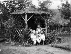
Sanders children in backyard
https://search.heritageburnaby.ca/link/museumdescription9890
- Repository
- Burnaby Village Museum
- Date
- 1928
- Collection/Fonds
- Gerald F. Sanders and Alice Sparman Sanders fonds
- Description Level
- Item
- Physical Description
- 1 photograph : b&w ; 18 x 23 cm
- Scope and Content
- Photograph of the Sanders children in their backyard, under a gazebo in the yard of their first house on Spruce Street near the corner of Spruce and Carlton Avenue. Gerald Sanders stands at the back with siblings Leslie, Reginald, and Eileen seated in front.
- Repository
- Burnaby Village Museum
- Collection/Fonds
- Gerald F. Sanders and Alice Sparman Sanders fonds
- Description Level
- Item
- Physical Description
- 1 photograph : b&w ; 18 x 23 cm
- Scope and Content
- Photograph of the Sanders children in their backyard, under a gazebo in the yard of their first house on Spruce Street near the corner of Spruce and Carlton Avenue. Gerald Sanders stands at the back with siblings Leslie, Reginald, and Eileen seated in front.
- Geographic Access
- Spruce Street
- Street Address
- 4092 Spruce Street
- Accession Code
- BV018.34.15
- Access Restriction
- No restrictions
- Reproduction Restriction
- No known restrictions
- Date
- 1928
- Media Type
- Photograph
- Historic Neighbourhood
- Broadview (Historic Neighbourhood)
- Planning Study Area
- Cascade-Schou Area
- Scan Resolution
- 600
- Scan Date
- 2022-07-12
- Notes
- Title based on contents of photograph
Images

Sanders family architectural drawings series
https://search.heritageburnaby.ca/link/museumdescription18835
- Repository
- Burnaby Village Museum
- Date
- [1946]
- Collection/Fonds
- Gerald F. Sanders and Alice Sparman Sanders fonds
- Description Level
- Series
- Physical Description
- 7 architectural drawings
- Scope and Content
- Series consists of architectural drawings titled "Homes of Comfort "Airdrie" Design pertaining to a house that was built by the Sanders family and was located on Spruce Street near the corner of Spruce Street and Carleton Avenue.
- Repository
- Burnaby Village Museum
- Collection/Fonds
- Gerald F. Sanders and Alice Sparman Sanders fonds
- Description Level
- Series
- Physical Description
- 7 architectural drawings
- Scope and Content
- Series consists of architectural drawings titled "Homes of Comfort "Airdrie" Design pertaining to a house that was built by the Sanders family and was located on Spruce Street near the corner of Spruce Street and Carleton Avenue.
- Accession Code
- BV018.34
- Access Restriction
- Subject to FIPPA
- Reproduction Restriction
- Reproductions subject to FIPPA
- Date
- [1946]
- Media Type
- Architectural Drawing
- Notes
- Title based on contents of series
Sidewalk Construction on Smith Avenue from Kingsway to Spruce Street
https://search.heritageburnaby.ca/link/councilreport49302
- Repository
- City of Burnaby Archives
- Report ID
- 48715
- Meeting Date
- 13-Jan-1947
- Format
- Council - Mayor/Councillor/Staff Report
- Collection/Fonds
- City Council and Office of the City Clerk fonds
- Repository
- City of Burnaby Archives
- Report ID
- 48715
- Meeting Date
- 13-Jan-1947
- Format
- Council - Mayor/Councillor/Staff Report
- Collection/Fonds
- City Council and Office of the City Clerk fonds
Documents
Smith Avenue Between Spruce Street and Fir Street
https://search.heritageburnaby.ca/link/councilreport12246
- Repository
- City of Burnaby Archives
- Report ID
- 12173
- Meeting Date
- 19-Feb-1990
- Format
- Council - Committee Report
- Collection/Fonds
- City Council and Office of the City Clerk fonds
- Repository
- City of Burnaby Archives
- Report ID
- 12173
- Meeting Date
- 19-Feb-1990
- Format
- Council - Committee Report
- Collection/Fonds
- City Council and Office of the City Clerk fonds
Documents
Spruce Street and Mahon Avenue
https://search.heritageburnaby.ca/link/councilreport38460
- Repository
- City of Burnaby Archives
- Report ID
- 34163
- Meeting Date
- 1-Apr-1963
- Format
- Council - Committee Report
- Collection/Fonds
- City Council and Office of the City Clerk fonds
- Repository
- City of Burnaby Archives
- Report ID
- 34163
- Meeting Date
- 1-Apr-1963
- Format
- Council - Committee Report
- Collection/Fonds
- City Council and Office of the City Clerk fonds
Documents
Spruce Street and Mahon Avenue
https://search.heritageburnaby.ca/link/councilreport39918
- Repository
- City of Burnaby Archives
- Report ID
- 35951
- Meeting Date
- 12-Jun-1961
- Format
- Council - Committee Report
- Collection/Fonds
- City Council and Office of the City Clerk fonds
- Repository
- City of Burnaby Archives
- Report ID
- 35951
- Meeting Date
- 12-Jun-1961
- Format
- Council - Committee Report
- Collection/Fonds
- City Council and Office of the City Clerk fonds
Documents
Spruce Street from Royal Oak Avenue to Grandview-Douglas Highway
https://search.heritageburnaby.ca/link/councilreport41384
- Repository
- City of Burnaby Archives
- Report ID
- 37685
- Meeting Date
- 20-Jul-1959
- Format
- Council - Committee Report
- Collection/Fonds
- City Council and Office of the City Clerk fonds
- Repository
- City of Burnaby Archives
- Report ID
- 37685
- Meeting Date
- 20-Jul-1959
- Format
- Council - Committee Report
- Collection/Fonds
- City Council and Office of the City Clerk fonds
Documents
Spruce Street Storm Drainage Works between Smith Avenue and Boundary Road
https://search.heritageburnaby.ca/link/councilreport37792
- Repository
- City of Burnaby Archives
- Report ID
- 32998
- Meeting Date
- 20-Jan-1964
- Format
- Council - Manager's Report
- Manager's Report No.
- 4
- Item No.
- 3
- Collection/Fonds
- City Council and Office of the City Clerk fonds
- Repository
- City of Burnaby Archives
- Report ID
- 32998
- Meeting Date
- 20-Jan-1964
- Format
- Council - Manager's Report
- Manager's Report No.
- 4
- Item No.
- 3
- Collection/Fonds
- City Council and Office of the City Clerk fonds
Documents
Strata Title Application No. 3/91 3894 Spruce Street
https://search.heritageburnaby.ca/link/councilreport11081
- Repository
- City of Burnaby Archives
- Report ID
- 7230
- Meeting Date
- 8-Jul-1991
- Format
- Council - Manager's Report
- Manager's Report No.
- 43
- Item No.
- 17
- Collection/Fonds
- City Council and Office of the City Clerk fonds
- Repository
- City of Burnaby Archives
- Report ID
- 7230
- Meeting Date
- 8-Jul-1991
- Format
- Council - Manager's Report
- Manager's Report No.
- 43
- Item No.
- 17
- Collection/Fonds
- City Council and Office of the City Clerk fonds
Documents
Subdivision Sidewalk Policy - Subdivision Reference # 42/68 (Spruce Street)
https://search.heritageburnaby.ca/link/councilreport33507
- Repository
- City of Burnaby Archives
- Report ID
- 29861
- Meeting Date
- 19-Aug-1968
- Format
- Council - Manager's Report
- Manager's Report No.
- 51
- Item No.
- 26
- Collection/Fonds
- City Council and Office of the City Clerk fonds
- Repository
- City of Burnaby Archives
- Report ID
- 29861
- Meeting Date
- 19-Aug-1968
- Format
- Council - Manager's Report
- Manager's Report No.
- 51
- Item No.
- 26
- Collection/Fonds
- City Council and Office of the City Clerk fonds
Documents
![Survey and Subdivision plans in New Westminster District Group 1 - Burnaby
, [1906-1910] thumbnail](/media/hpo/_Data/_BVM_Cartographic_Material/1977/1977_0093_0001a_001.jpg?width=280)
Survey and Subdivision plans in New Westminster District Group 1 - Burnaby
https://search.heritageburnaby.ca/link/museumdescription6970
- Repository
- Burnaby Village Museum
- Date
- [1906-1910]
- Collection/Fonds
- Burnaby Village Museum Map collection
- Description Level
- File
- Physical Description
- 7 plans : blueprint ink on paper + 2 plans : black ink on paper mounted on 2 sides of cardboard 76 cm x 102 cm
- Scope and Content
- Item consists of a large board of six New Westminster District Gp 1 subdivision plans mounted on one side and three New Westminster District Gp 1 subdivision plans mounted on the other side with scales ranging from one chain equals one inch to four chains equals one inch. Side A: 1. Blueprint "Pl…
- Repository
- Burnaby Village Museum
- Collection/Fonds
- Burnaby Village Museum Map collection
- Description Level
- File
- Physical Description
- 7 plans : blueprint ink on paper + 2 plans : black ink on paper mounted on 2 sides of cardboard 76 cm x 102 cm
- Material Details
- Scales [1:792] and [1:3168]
- Index number on edge of board reads: "1"
- Scope and Content
- Item consists of a large board of six New Westminster District Gp 1 subdivision plans mounted on one side and three New Westminster District Gp 1 subdivision plans mounted on the other side with scales ranging from one chain equals one inch to four chains equals one inch. Side A: 1. Blueprint "Plan / of Subdivision / of a portion / of / Lot 13, GR.1 / New Westminster District". Plan is bordered by Cumberland Street, Tenth Ave., Cariboo Street, Armstrong Street, "See Bd.145", Map No891 (Geographic location: Burnaby) 2."Plan / of Subdivision / of a portion / of / Lot 13, GR.1 / New Westminster District". Plan is bordered by Cumberland Street, Tenth Ave., Cariboo St. and Armstrong St. Pencilled annotations on plan read: "for Subdivisions see Board 145"; "Subdivided by H. Neville Smith". (Geographic location: Burnaby) 3. Blueprint "Plan / of Subdivision / of a part / of / Lot 155 / Group 1 / New Westminster District". Plan is bordered by North Arm of Fraser, Wiggins Rd. and Lot 173. Plan created by "NB Gauvreau" (Geographic location: Burnaby) Side B: 1. Blueprint plan which reads: "Albert J. Hill / P.L.S." at top with handwritten annotation: "Lot 85". The plan is bordered by Hastings Rd. and Burnaby Lake with names on lots identified as:"Laura Troop; Jas. Anderson and A. de W. Haszard". (Geographic location: Burnaby) 2. Blueprint plan which reads: "Albert J. Hill / P.L.S" at top with handwritten annotation: "Lot 85". The plan is bordered by Hastings Rd. and Burnaby Lake with names on lots identified as:"Laura Troop; A. de W. Haszard". (Geographic location: Burnaby) 3.Plan of "Survey of Road / for / Burnaby Council". "Albert J. Hill, M.A. Civil Engineer". Plan identifies "Centre Line Lot 10 / Present Road" at the centre and is bordered by Gunn Rd. at the top and Brunette River at the bottom. (Geographic location: Burnaby) 4.Blueprint "Plan / of Subdivision / Lot 97 Group 1/ N.W.D." Plan is bordered by Lots 93, 94 and 96 and Webster Road. Vancouver and New Westminster Road crosses the upper right corner of the plan and the New Westminster Vancouver Tramway runs through from Power House Rd. to Webster Road. Lower right corner identifies "W.N. Draper, P.LotS." (Geographic location: Burnaby) 5. Blueprint "Plan / of / The Subdivision of / Portion of / Lot 85, GP.1 / New Westminster District" Plan is bordered by Lots 79 / Byrne Drive; Burnaby Lake/ Esplanade and Lot 87. Plan is identified with "Albert J. Hill / B.C.LotS. / 19/6/09" (Geographic location: Burnaby) 6. Blueprint "Plan / of Subdivision/ of / Lot 155B, Group One / New Westminster District". Plan is bordered by Lots 155A, 155C, 162 / Byrne Road, 166A / Wiggins Road with Spruce Street running through the middle and Westminster- Eburne Ry. Right of Way running diagonally. Plan is identified with "Albert J. Hill (Geographic location: Burnaby)
- Accession Code
- HV977.93.1
- Access Restriction
- No restrictions
- Reproduction Restriction
- No known restrictions
- Date
- [1906-1910]
- Media Type
- Cartographic Material
- Scan Resolution
- 300
- Scan Date
- 2019-07-16
- Scale
- 72
- Notes
- Title based on contents of file
- Stamp on plans reads: "ALBERT J. HILL M.A. / CIVIL ENGINEER / and / PROVINCIAL LAND SURVEYOR / NEW WESTMINSTER / BC"
- Scale is measured in chains. (One chain equals 792 inches)
Images
![Survey and Subdivision plans in New Westminster District Group 1 - Burnaby
, [1906-1910] thumbnail](/media/hpo/_Data/_BVM_Cartographic_Material/1977/1977_0093_0001a_001.jpg)

Tender of Dominion Construction Co. for the Construction of Auxillary Main on Douglas Road and Spruce Street
https://search.heritageburnaby.ca/link/councilreport68063
- Repository
- City of Burnaby Archives
- Report ID
- 59001
- Meeting Date
- 24-Oct-1921
- Format
- Council - Mayor/Councillor/Staff Report
- Collection/Fonds
- City Council and Office of the City Clerk fonds
- Repository
- City of Burnaby Archives
- Report ID
- 59001
- Meeting Date
- 24-Oct-1921
- Format
- Council - Mayor/Councillor/Staff Report
- Collection/Fonds
- City Council and Office of the City Clerk fonds
Documents
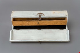
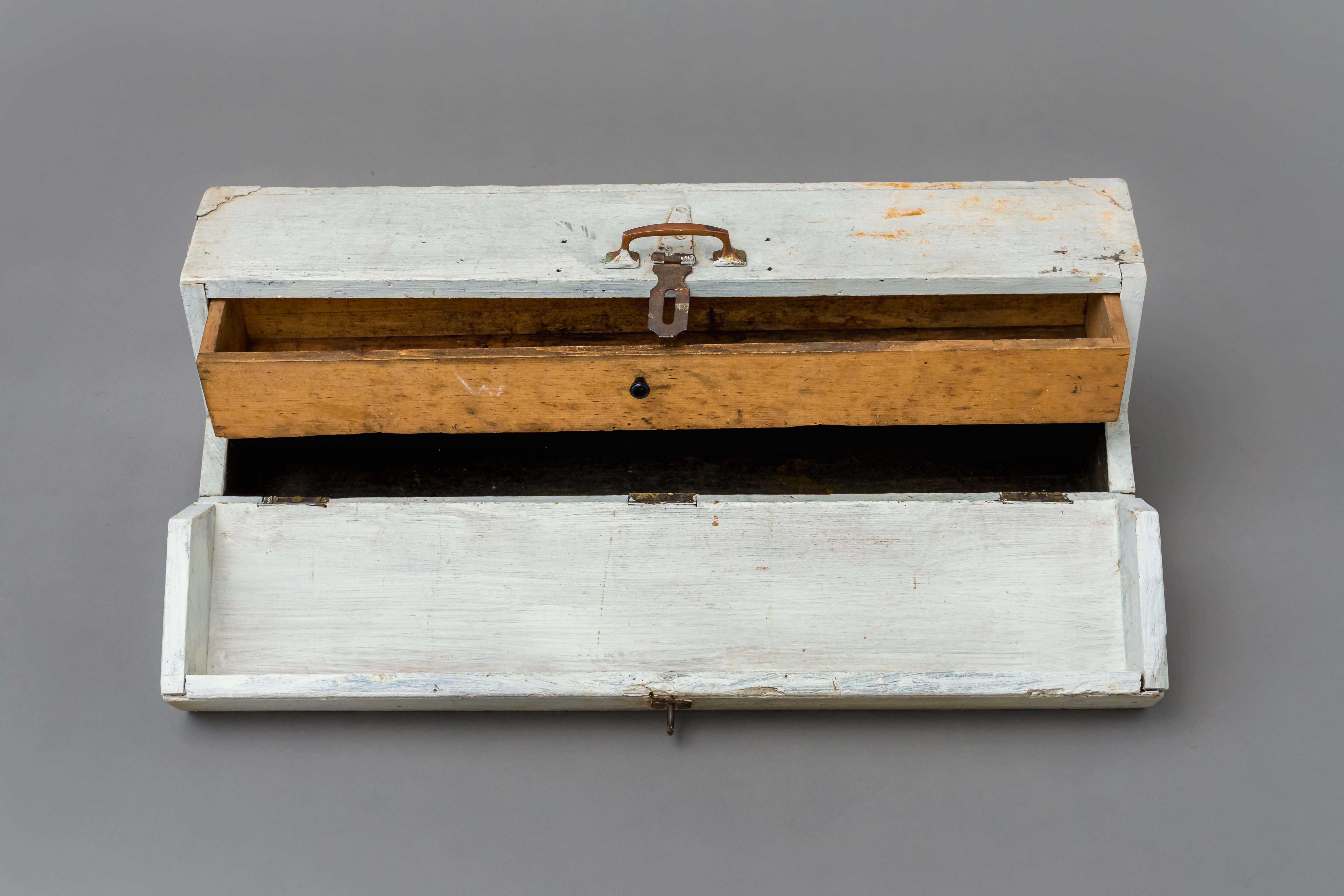
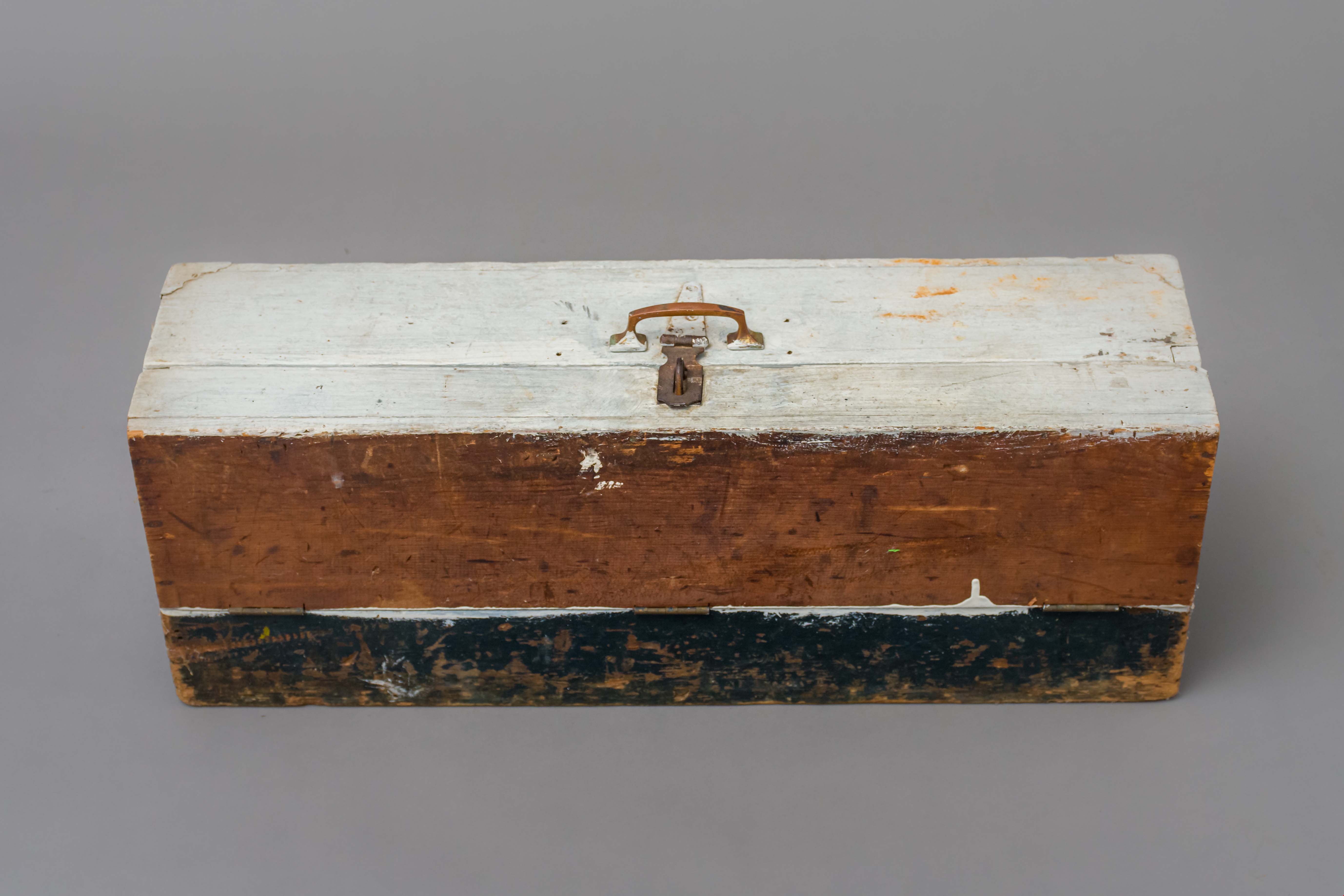
Toolbox
https://search.heritageburnaby.ca/link/museumartifact89169
- Repository
- Burnaby Village Museum
- Accession Code
- BV018.23.2
- Description
- toolbox; hand-made toolbox with pull-out interior drawer; wood with 3/4 fold-down lid, metal carry handle and lock hasp; steel hinges and two metal corners at top of box; white and black paint; unpainted wood interior drawer with small pull handle.
- Object History
- This tool box was made by donor's father David, who worked as a machinest at Heaps Engineering in New Westminster. David was born in Scotland in 1882 and immigrated to Canada. He lived in Spruce Street and Telford Street in Burnaby. His children atteneded Kingsway West Elementary School, South Burnaby and King Edward High School.
- Category
- 04.Tools & Equipment for Materials
- Classification
- Multiple Use T&E for Materials
- Object Term
- Container, Tool
- Measurements
- L: 71.2 cm W: 20.0 H: 25.0 cm
- Historic Neighbourhood
- Central Park (Historic Neighbourhood)
- Planning Study Area
- Maywood Area
Images