Narrow Results By
Subject
- Adornment - Lapel Pins 1
- Advertising Medium 2
- Advertising Medium - Flyer 1
- Advertising Medium - Poster 1
- Advertising Medium - Signs and Signboards 1
- Building Components 1
- Buildings - Judicial - Courthouses 1
- Celebrations 3
- Celebrations - Centennials 9
- Ceremonial Artifacts 2
- Ceremonies 1
- Clothing - Accessory 1
Person / Organization
- Air Raid Precautions (A.R.P.) 1
- British Columbia Electric Railway Company 1
- Burnaby Centennial '71 Committee 8
- Burnaby Village Museum 13
- Canada Summer Games 1
- Century Park Museum Association 5
- Cutress, Harry Charles 1
- Galbraith, Eleanor Lois 1
- G.F. and J. Galt Limited 1
- Girl Guides of Canada 4
- Love Family 1
- Love, Jesse, 1849-1928 1

William Holmes House
https://search.heritageburnaby.ca/link/landmark736
- Repository
- Burnaby Heritage Planning
- Geographic Access
- North Road
- Brunette River
- Associated Dates
- 1860
- Heritage Value
- William Holmes is considered to be the first non-Native resident of Burnaby. In March, 1860, Holmes acquired the first land title in the area that would become the Municipality of Burnaby. Legally known as Lot One, Block One, this parcel was located on North Road and the Brunette River. The eight-member Holmes family built a log cabin on the lot on a bluff above the river in which they lived for many years until a bigger home was built. The log cabin remained and in 1892 was used as an isolation hospital when a smallpox epidemic hit the lower mainland. Afterwards, local health officials burned the cabin to prevent the spread of disease.
- Planning Study Area
- Cariboo-Armstrong Area
Images


City of Burnaby Archives
https://search.heritageburnaby.ca/link/landmark783
- Repository
- Burnaby Heritage Planning
- Geographic Access
- Albert Street
- Associated Dates
- 2001
- Heritage Value
- The City of Burnaby Archives officially opened on Saturday, November 10, 2001. The Archives is Burnaby's first municipal archives, and is located in the McGill Branch Library. The City Archives functions as a branch of the Office of the City Clerk and operates as the official repository of Burnaby's municipal records, containing records dating back to Burnaby's incorporation in 1892. In 2007, the City of Burnaby Archives expanded its collection mandate to include private as well as public records. On February 14, 2007 an agreement was signed with the Burnaby Historical Society and, as a result, the Archives accepted into its custody the collection of community records that had been maintained and managed by the Historical Society since the 1950s. In the Spring of 2007, these records were transferred from the Burnaby Village Museum to their permanent home in the Archives facility.
- Historic Neighbourhood
- Capitol Hill (Historic Neighbourhood)
- Planning Study Area
- Capitol Hill Area
- Street Address
- 4595 Albert Street
- Street View URL
- Google Maps Street View
Images


Barnet Mountain Park Dedication
https://search.heritageburnaby.ca/link/landmark686
- Repository
- Burnaby Heritage Planning
- Associated Dates
- 1942
- Heritage Value
- For years, the idea of creating a park on Burnaby Mountain was favoured by people in Burnaby. In 1930, the Municipal Engineer submitted a report recommending that the city acquire land in the area with a view towards formally dedicating the space for public use. In 1942, Commissioner Richard Bolton enacted Bylaw 1772 which officially dedicated the mountain as public park.
- Historic Neighbourhood
- Barnet (Historic Neighbourhood)
- Planning Study Area
- Burnaby Mountain Area
Images


Brentwood Neighbourhood
https://search.heritageburnaby.ca/link/landmark780
- Repository
- Burnaby Heritage Planning
- Associated Dates
- 1955-2008
- Heritage Value
- Between 1955 and 2001, the Brentwood Neighbourhood developed into one of Burnaby's four official Town Centres. The Brentwood Town Centre serves the north-west sector of the Municipality, providing facilities such as commercial developments - of which the Brentwood Mall is the most significant. Under Burnaby's Residential Development Framework adopted by Council in 1981, the Town Centre also incorporated a full range of multi-housing types and forms in close relationship with their commercial facilities. In 1996, the City adopted the Brentwood Town Centre Development Plant to solidify the area as a focus of higher-density and higher-intensity residential and commercial opportunities, public transit and supporting leisure facilities.
- Planning Study Area
- Brentwood Area
Images


Burnaby Municipal Hall
https://search.heritageburnaby.ca/link/landmark807
- Repository
- Burnaby Heritage Planning
- Geographic Access
- Canada Way
- Associated Dates
- 1956
- Heritage Value
- When staff outgrew the municipal buildings at Edmonds and Kingsway, a debate erupted over where to build a new municipal hall. North Burnaby residents argued against the Kingsway and Edmonds site as it was too removed for their needs, but South Burnaby residents were not prepared to accept a hall in North Burnaby. The debate was finally resolved when it was suggested that the new civic centre for the municipality be in the exact geographic centre of Burnaby. Fortunately, this meant that the new hall was to be built near Deer Lake, in the beautiful Central Valley setting. Burnaby voters accepted this decision and approved the $625,000.00 it would take to build the new structure and the official opening ceremony was held June 22, 1956 when then Reeve Charles MacSorley received the keys to the hall from the contractor.
- Historic Neighbourhood
- Burnaby Lake (Historic Neighbourhood)
- Planning Study Area
- Douglas-Gilpin Area
- Street Address
- 4949 Canada Way
- Street View URL
- Google Maps Street View
Images


Burnaby Village Museum
https://search.heritageburnaby.ca/link/landmark808
- Repository
- Burnaby Heritage Planning
- Geographic Access
- Deer Lake Avenue
- Associated Dates
- 1971
- Heritage Value
- The Burnaby Village Museum is a ten-acre heritage site located adjacent to Deer Lake. The site was originally created as a B.C. Centennial Project in 1971. The official sod turning for was April 11, 1971 by the then Governor General of Canada Roland Mitchener. The Village was initially managed by the Century Park Museum Association, a volunteer society of Burnaby citizens. Over the years many heritage building which could not be maintained in their original locations have been moved to the museum. Today half of the buildings in the village are heritage structures and the remainder are reproductions. In 1990 the City of Burnaby assumed direct management of the Village, and the museum became part of the Parks, Recreation and Culture Department. Visitors can enjoy the shops on Hill Street, ride the Parker 119 Carousel, and climb aboard the Interurban 1223 tram.
- Historic Neighbourhood
- Burnaby Lake (Historic Neighbourhood)
- Planning Study Area
- Douglas-Gilpin Area
- Morley-Buckingham Area
- Street Address
- 6501 Deer Lake Avenue
- Street View URL
- Google Maps Street View
Images


Confederation Park
https://search.heritageburnaby.ca/link/landmark672
- Repository
- Burnaby Heritage Planning
- Geographic Access
- Willingdon Avenue
- Associated Dates
- 1927
- Heritage Value
- North Burnaby’s first park began its life as the Capitol Hill subdivision during the land boom of 1909. In 1914 the boom went bust and many owners of unoccupied lots failed to pay the property taxes owing and the land became the property of the Municipality of Burnaby. By 1922, Burnaby had so many lots that it decided to reserve land for future park use and dedicated a narrow 26 acre site adjacent to the ravine. During the 1920s, the Heights area boomed again and many new residents wanted a playground for their children. A local women’s group took on the cause and enlisted local residents and businesses to raise the necessary funds. On June 25, 1927 crowds gathered to officially dedicate “Confederation Park” named in honour of the Diamond Jubilee of Canada’s Confederation (1867-1927).
- Historic Neighbourhood
- Capitol Hill (Historic Neighbourhood)
- Planning Study Area
- Capitol Hill Area
- Street Address
- 250 Willingdon Avenue
- Street View URL
- Google Maps Street View
Images


Mortimer-Lamb House
https://search.heritageburnaby.ca/link/landmark494
- Repository
- Burnaby Heritage Planning
- Description
- The Mortimer-Lamb House is a one and one half-storey, Arts and Crafts-style residence with a steeply pitched, side-gabled roof. The original cottage form has been enlarged with a later addition on the west side of the house. Located next to the Burnaby Lake Regional Park Wildlife Rescue Care Centre…
- Associated Dates
- c.1922
- Formal Recognition
- Community Heritage Register
- Other Names
- Harold & Katherine Mortimer-Lamb Residence
- Street View URL
- Google Maps Street View
- Repository
- Burnaby Heritage Planning
- Other Names
- Harold & Katherine Mortimer-Lamb Residence
- Geographic Access
- Glencarin Drive
- Associated Dates
- c.1922
- Formal Recognition
- Community Heritage Register
- Enactment Type
- Council Resolution
- Enactment Date
- 26/05/2003
- Description
- The Mortimer-Lamb House is a one and one half-storey, Arts and Crafts-style residence with a steeply pitched, side-gabled roof. The original cottage form has been enlarged with a later addition on the west side of the house. Located next to the Burnaby Lake Regional Park Wildlife Rescue Care Centre, the house has picturesque views of Burnaby Lake.
- Heritage Value
- Built circa 1922, the Mortimer-Lamb House is valued for its association with first owners, Harold Mortimer-Lamb (1872-1970), and his wife, Katherine Mary Mortimer-Lamb (1873-1939). Born in Leatherhead, Surrey, England, Harold Mortimer-Lamb immigrated to Canada in 1889. Seven years later in Vancouver, he married Katherine Mary Lindsay, a native of Winnipeg. Mortimer-Lamb was a key figure in the B.C. mining industry, serving as Secretary of the Mining Association of B.C. between 1900 and 1945, and also as the Secretary of the Canadian Institute of Mining and Metallurgy. In addition to his professional life, Mortimer-Lamb was a pioneer art photographer and was among Canada's leading art critics, and this house served as a central gathering place for renowned Canadian artists of the day. Mortimer-Lamb’s daughter, Molly Lamb Bobak (born 1922), became a renowned watercolourist, and was the only woman ever hired as an official Canadian war artist. The Mortimer-Lamb House is a significant example of the work of noted architect, Samuel Maclure (1860-1929) and his partner, Ross Lort (1889-1969). Maclure, who was a close friend of the Mortimer-Lamb family, was British Columbia's leading residential architect, and was renowned for his high quality designs for prominent citizens in both Vancouver and Victoria. Maclure was a leading exponent of the Art and Crafts design movement in B.C., and established a sophisticated local variation of residential architecture. The Mortimer-Lamb House was designed at the time when Maclure was in partnership with Ross Lort. In 1907, Lort began working for Maclure's firm as a draftsman, and by 1920 was in charge of Maclure's Vancouver office. Lort's architectural career spanned some sixty-years, and he designed some of the province's most familiar houses, apartments, institutions and places of worship. The Mortimer-Lamb House is also a significant local example of the Arts and Crafts style, and incorporates elements such as board-and-batten siding on the ground floor, shingled gables and leaded casement windows. It is a testament to the domestic architecture built outside of established suburbs during the post-First World War era, typically modest in scale and representative of middle-class residential ideals.
- Defining Elements
- Key elements that define the heritage character of the Mortimer-Lamb House include its: - treed setting with views of Burnaby Lake - residential form, scale and massing as expressed by its one and one-half storey height, rectangular plan and steeply pitched side-gabled roof - wood-frame construction - Arts and Crafts elements such as board-and-batten siding on the ground floor, cedar shingles in the gables and open soffits - original straight-leaded casement windows in single and multiple-assembly - internal red-brick chimney with corbelled cap
- Historic Neighbourhood
- Burnaby Lake (Historic Neighbourhood)
- Planning Study Area
- Burnaby Lake Area
- Organization
- Mining Association of B.C.
- G.F. and J. Galt Limited
- Architect
- Samuel Maclure
- Ross Lort
- Function
- Primary Historic--Single Dwelling
- Primary Current--Single Dwelling
- Community
- Burnaby Lake
- Cadastral Identifier
- P.I.D.002-977-788
- Boundaries
- The Mortimer-Lamb House is comprised of a single residential lot located at 5180 Glencairn Drive, Burnaby.
- Area
- 5652.78
- Contributing Resource
- Building
- Ownership
- Private
- Documentation
- City of Burnaby Planning and Building Department, Heritage Site Files
- Street Address
- 5180 Glencarin Drive
- Street View URL
- Google Maps Street View
Images


Richmond Park Neighbourhood
https://search.heritageburnaby.ca/link/landmark828
- Repository
- Burnaby Heritage Planning
- Associated Dates
- 1955-2008
- Heritage Value
- The Richmond Park Neighbourhood is part of the larger Edmonds Town Centre - one of four official Town Centres in the City. Richmond Park contains a residential subdivision that developed during the 1950s as well as a strong commercial and retail centre along Edmonds and Kingsway.
- Historic Neighbourhood
- Edmonds (Historic Neighbourhood)
- Planning Study Area
- Richmond Park Area
Images


Standard Oil Company / Chevron
https://search.heritageburnaby.ca/link/landmark673
- Repository
- Burnaby Heritage Planning
- Geographic Access
- Willingdon Avenue North
- Associated Dates
- 1935
- Heritage Value
- In 1935 the announcement that the California-based Standard Oil Company was going to build a huge "million dollar" refinery in Burnaby was greeted with cheers by residents who were eager for employment and good news during the Great Depression. The refinery, named Stanovan (aka: Standard Oil - Vancouver) was officially opened in 1936 with the ability to produce 2000 barrels per day. During World War Two, the capacity of the refinery doubled to assist in the war effort. In 1976, the company's name was changed to Chevron Canada Limited.
- Historic Neighbourhood
- Vancouver Heights (Historic Neighbourhood)
- Planning Study Area
- Burnaby Heights Area
- Street Address
- 355 Willingdon Avenue North
Images


St. Nicholas Anglican Church
https://search.heritageburnaby.ca/link/landmark641
- Repository
- Burnaby Heritage Planning
- Description
- Church building.
- Associated Dates
- 1912
- Street View URL
- Google Maps Street View
- Repository
- Burnaby Heritage Planning
- Geographic Access
- Triumph Street
- Associated Dates
- 1912
- Description
- Church building.
- Heritage Value
- This church was one of the first built in North Burnaby to serve the new community of Vancouver Heights. Designed by architect Frank Barrs and constructed by local builders, Arthur England and Mr. Scott, it reflected the English roots of the Anglican Church with its fine Arts and Crafts style. It was officially opened in an impressive ceremony by the Bishop of New Westminster and could accommodate 200 worshippers. It was named after Saint Nicholas, the patron saint of sailors. The adjoining parish hall was completed in 1920. The church building features a gabled roof, triangular eave brackets and a semi-octagonal apse. Stucco has been applied to the exterior, but it retains its original form, scale and massing. It now houses the Burnaby Pacific Grace Church. English-born Frank Barrs (1871-1963) arrived in Vancouver in 1907 and established an office for about one year before he began working for the Vancouver Exhibition Association. He briefly established a partnership (1912-1913) with Samuel Shewbrooks (1877-1957), and was active as an architect until about 1933.
- Locality
- Vancouver Heights
- Historic Neighbourhood
- Vancouver Heights (Historic Neighbourhood)
- Planning Study Area
- Burnaby Heights Area
- Architect
- Frank A.A. Barrs
- Area
- 1695.45
- Contributing Resource
- Building
- Ownership
- Private
- Street Address
- 3883 Triumph Street
- Street View URL
- Google Maps Street View
Images


Swangard Stadium
https://search.heritageburnaby.ca/link/landmark818
- Repository
- Burnaby Heritage Planning
- Geographic Access
- Imperial Street
- Associated Dates
- 1969
- Heritage Value
- On 26 April 1969 Swangard Stadium held its official opening. Named after Vancouver Sun former Managing Editor, Erwin Swangard, the stadium was funded entirely from private donations and civic and provincial grants.
- Historic Neighbourhood
- Central Park (Historic Neighbourhood)
- Planning Study Area
- Maywood Area
- Street Address
- 3883 Imperial Street
Images

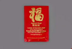
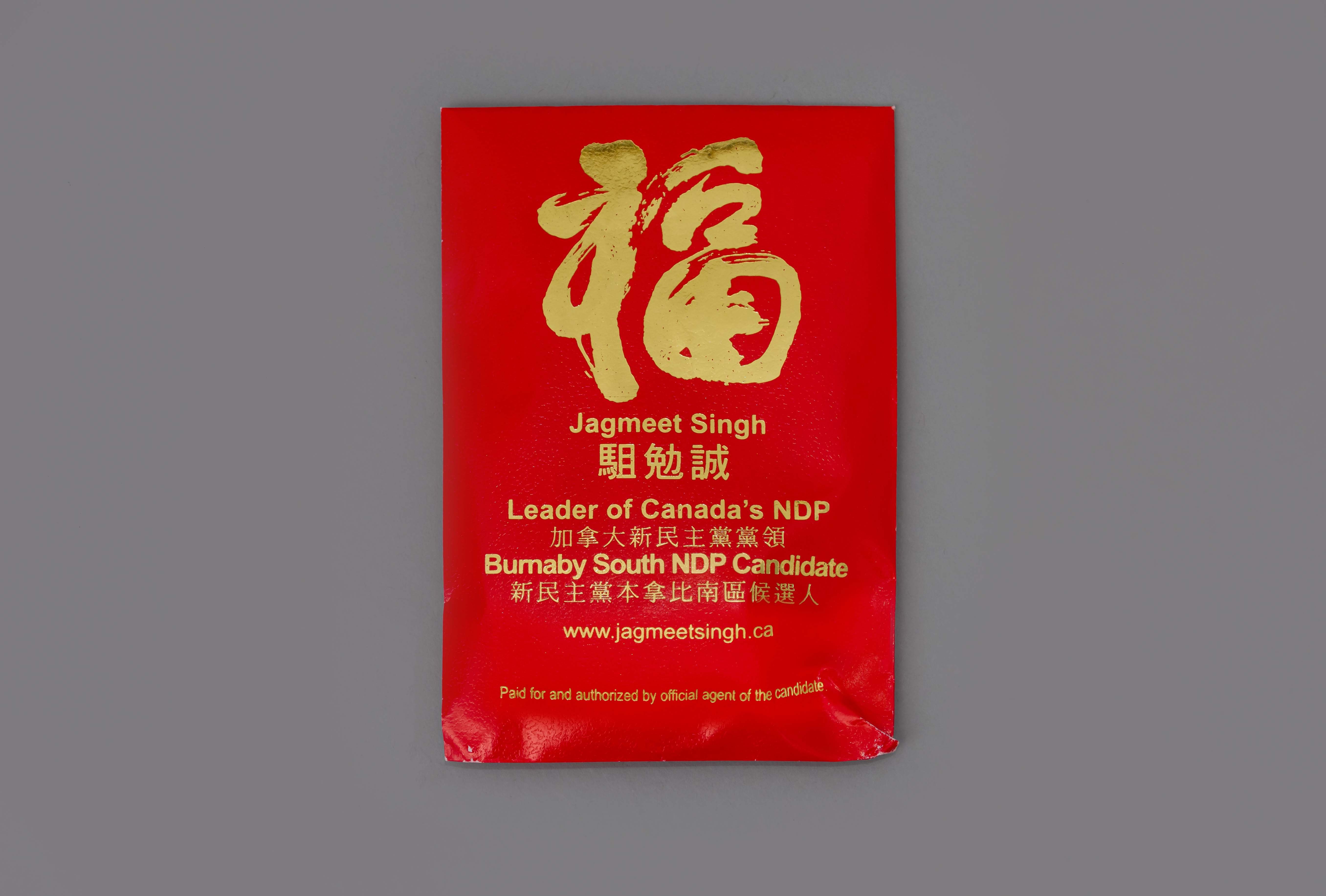
Chinese New Year envelope
https://search.heritageburnaby.ca/link/museumartifact89950
- Repository
- Burnaby Village Museum
- Accession Code
- BV019.16.3
- Description
- Chinese New Year envelope; red paper with gummed, fold closure at top; text in Chinese and English in gold reading: "Jagmeet Singh / Leader of Canada's NDP / Burnaby South NDP Candidate / www.jagmeetsingh.ca / Paid for and authorized by official agent of the candidate."; contains a small, square orange-flavoured candy and a thin card; card has the candidate's name and photograph on one side, and the Chinese zodiac on the other.
- Object History
- Jagmeet Singh is a Canadian lawyer and politician serving as leader of the New Democratic Party since 2017. He was elected as the Member of Parliament (MP) for the riding of Burnaby South in a February 25, 2019 by-election.
- Classification
- Merchandising T&E
- Object Term
- Envelope, Money
- Subjects
- Advertising Medium
- Holidays - Chinese New Year
- Persons - South Asian Canadians
- Officials - Elected Officials
- Celebrations
- Names
- Singh, Jagmeet
Images
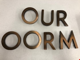
Building Letters
https://search.heritageburnaby.ca/link/museumartifact90803
- Repository
- Burnaby Village Museum
- Accession Code
- BV020.40.1
- Description
- Eight bronze capital letters: "OURT ROOM" Each letter has small protrusions on the backside where they were afixed to the exterior wall of Burnaby's Provincial courtroom.
- Object History
- The Court Room letters came from the 1965 Provincial Courthouse built adjacent to City Hall at 4949 Canada Way. This courtroom closed down in 2002.
- Object Term
- Sign, Identification
- Marks/Labels
- "OUR ROOM" is missing the C and the "T" to finish spelling courtroom.
- Colour
- Bronze
- Measurements
- 6" in height
- Subjects
- Building Components
- Buildings - Judicial - Courthouses
- Government - Provincial Government
- Officials - Judges
- Historic Neighbourhood
- Burnaby Lake (Historic Neighbourhood)
- Planning Study Area
- Douglas-Gilpin Area
Images
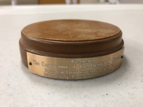
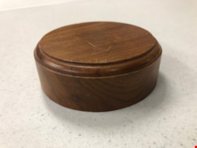
Gavel Pad
https://search.heritageburnaby.ca/link/museumartifact90815
- Repository
- Burnaby Village Museum
- Accession Code
- BV020.40.6
- Description
- Varnished and beveled wooden cylinder, used to provide a place to bang a gavel. The top surfaces is dented and scratched with use. There is a small, golden coloured metal plaque nailed into the side of the gavel pad with 2 nails. It reads "Presented to The Corporation of The District of Burnaby / Operation Identification 15-5-78 / by Burnaby Kingsway Rotary Club
- Object History
- Gavel pad used by Mayor William Copland (1987-1996). William “Bill” Copeland once joked that the reason he ran for mayor of Burnaby was because “there wasn’t a shadow of hope he would be successful” – and when the votes were tallied and he was declared victorious, Bill asked for a recount. Fortunately for the people of Burnaby, he was not serious and instead went on to become an overwhelmingly popular and much-respected leader of the community. Bill’s service to his community began early in life. Born in Vancouver on May 19, 1927, Bill was still a young man when World War Two began but that did not stop him from serving in the Merchant Marines and in the Royal Canadian Navy. After the war, Bill and his wife Ruth raised three children and in 1955 he embarked on a career with the Burnaby Fire Department. Bill went on to serve Burnaby as a firefighter until his retirement in 1987 as an Assistant Fire Chief. During this lengthy tenure, Bill held a leadership role in the Firefighters’ Union Local 323 and served as Vice President of the 6th District of the International Association of Firefighters. Over the years, Bill found various ways to contribute to the people of Burnaby. In conjunction with his work with the Fire Department, Bill was also President of the Burnaby Red Cross, Director of the Canadian National Institute for the Blind, Chairman of the St. John Ambulance, Life Member of the Burnaby North Lions Club and Member of the Deer Lake Chapter of the Rotary Club – to name but a very few of the numerous groups and organizations to which he belonged. Immediately upon his retirement from the Fire Department in 1987, Bill was asked to run for the position of Mayor of Burnaby and was successful in his bid. As Mayor, Bill earned the respect of Council and the citizens of Burnaby for his outstanding work and dedication to the community. Bill was an advocate of public participation and introduced the concept of “Area Advisory Committees” to the City with the appointment of the Hastings Street Advisory Committee. The success of this process has led to many other appointments for area advisory committees throughout Burnaby. Bill did not limit his good works to stay within the borders of the City, and as Mayor he was responsible for the two-year sister city twinning agreement with the city of El Zapotal, El Salvador. This campaign saw the citizens of Burnaby embark on numerous initiatives and fundraisers to offer support and assistance to this developing area. In 1996, Bill retired from public life after serving three terms in office and in 1997, in recognition of Bill’s contribution to the community both as a firefighter and as Mayor, the newly constructed ice arena at Burnaby Lake Sports Complex was officially named the “Bill Copeland Sports Centre,” and in 2001, Bill was made a Freeman of the City. William Copeland died August 30, 2002.
- Category
- 08. Communication Artifacts
- Classification
- Ceremonial Artifacts
- Object Term
- Gavel
- Colour
- Brown
- Gold
- Measurements
- 4 inches in diameter
- Historic Neighbourhood
- Burnaby Lake (Historic Neighbourhood)
- Planning Study Area
- Douglas-Gilpin Area
Images

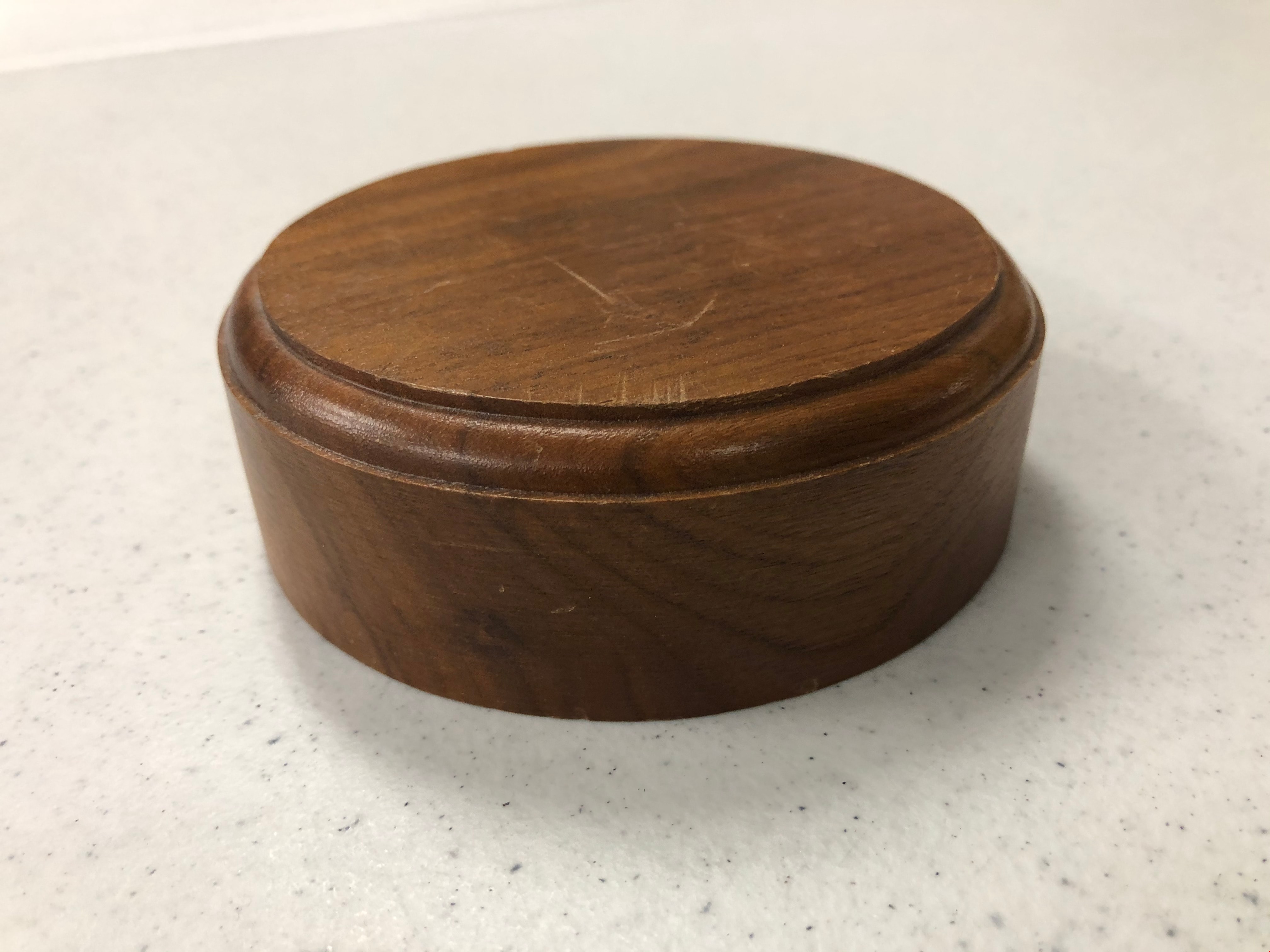
Gavel Pad
https://search.heritageburnaby.ca/link/museumartifact90816
- Repository
- Burnaby Village Museum
- Accession Code
- BV020.40.7
- Description
- Varnished and beveled wooden cylinder, used to provide a place to bang a gavel. The top surfaces is dented and scratched with use.
- Object History
- Gavel pad used by Mayor William Copland (1987-1996). William “Bill” Copeland once joked that the reason he ran for mayor of Burnaby was because “there wasn’t a shadow of hope he would be successful” – and when the votes were tallied and he was declared victorious, Bill asked for a recount. Fortunately for the people of Burnaby, he was not serious and instead went on to become an overwhelmingly popular and much-respected leader of the community. Bill’s service to his community began early in life. Born in Vancouver on May 19, 1927, Bill was still a young man when World War Two began but that did not stop him from serving in the Merchant Marines and in the Royal Canadian Navy. After the war, Bill and his wife Ruth raised three children and in 1955 he embarked on a career with the Burnaby Fire Department. Bill went on to serve Burnaby as a firefighter until his retirement in 1987 as an Assistant Fire Chief. During this lengthy tenure, Bill held a leadership role in the Firefighters’ Union Local 323 and served as Vice President of the 6th District of the International Association of Firefighters. Over the years, Bill found various ways to contribute to the people of Burnaby. In conjunction with his work with the Fire Department, Bill was also President of the Burnaby Red Cross, Director of the Canadian National Institute for the Blind, Chairman of the St. John Ambulance, Life Member of the Burnaby North Lions Club and Member of the Deer Lake Chapter of the Rotary Club – to name but a very few of the numerous groups and organizations to which he belonged. Immediately upon his retirement from the Fire Department in 1987, Bill was asked to run for the position of Mayor of Burnaby and was successful in his bid. As Mayor, Bill earned the respect of Council and the citizens of Burnaby for his outstanding work and dedication to the community. Bill was an advocate of public participation and introduced the concept of “Area Advisory Committees” to the City with the appointment of the Hastings Street Advisory Committee. The success of this process has led to many other appointments for area advisory committees throughout Burnaby. Bill did not limit his good works to stay within the borders of the City, and as Mayor he was responsible for the two-year sister city twinning agreement with the city of El Zapotal, El Salvador. This campaign saw the citizens of Burnaby embark on numerous initiatives and fundraisers to offer support and assistance to this developing area. In 1996, Bill retired from public life after serving three terms in office and in 1997, in recognition of Bill’s contribution to the community both as a firefighter and as Mayor, the newly constructed ice arena at Burnaby Lake Sports Complex was officially named the “Bill Copeland Sports Centre,” and in 2001, Bill was made a Freeman of the City. William Copeland died August 30, 2002.
- Category
- 08. Communication Artifacts
- Classification
- Ceremonial Artifacts
- Object Term
- Gavel
- Colour
- Brown
- Measurements
- 4 inches in diameter
- Historic Neighbourhood
- Burnaby Lake (Historic Neighbourhood)
- Planning Study Area
- Douglas-Gilpin Area
Images
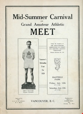
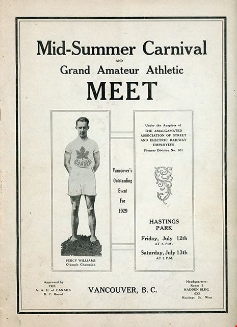
program
https://search.heritageburnaby.ca/link/museumartifact81780
- Repository
- Burnaby Village Museum
- Accession Code
- BV009.12.1
- Description
- Souvenir program for "Mid-Summer Carnival / AND / Grand Amateur Athletic / Meet / UNDER THE AUSPICES OF / THE AMALGAMATED ASSOICATION OF STREET AND ELECTRIC RAILWAY EMPLOYEES / PIONEER DIVISION NO. 101 / VANCOUVER, B. C., FRIDAY, JULY 12TH, at 5 P.M. / and SATURDAY, JULY 13TH, at 2 P.M. / HASTINGS PARK / VANCOUVER'S OUTSTANDING EVENT FOR 1929" printed on the facing page of the program. Program consists of 32 pages inside a blue tinted cover, stapled binding. Program includes a list of officials, list of events, list of participants along with photographs, illustrations and advertising. Handwritten annotations are visible on the list of officials and the events pages. Program is "Approved by / THE / A.A.U. of CANADA / B.C. Board / Headquarters: Room 5 / HADDEN BLDG. / 633 / Hastings St. West"
- Object History
- Item belonged to a teacher in Steveston who attended the event in 1929.
- Category
- 08. Communication Artifacts
- Classification
- Documentary Artifacts - - Other Documents
- Object Term
- Program
- Measurements
- 30.5 cm X 22.5 cm
- Country Made
- Canada
- Province Made
- British Columbia
- Site/City Made
- Vancouver
- Title
- Mid-Summer Carnival and Grand Amateur Athletic Meet
- Publication Date
- 1929
Images
invitation
https://search.heritageburnaby.ca/link/museumartifact91454
- Repository
- Burnaby Village Museum
- Accession Code
- BV020.5.2152
- Description
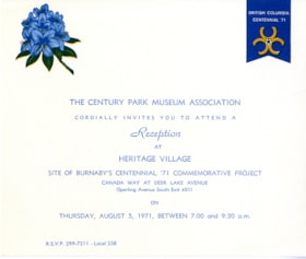
- Invitation, white card stock with blue and yellow. Burnaby Centennial '71 Committee logo and blue rhododendron flower in upper corners; Invitation reads: "The Century Park Museum Association / Cordially invites you to attend a / Reception / at / Heritage Village / Site of Burnaby's Centennial '71 Commemorative Project / ... Thursday, August 5, 1971, Between 7:00 and 9:30 p.m."
- Object History
- Invitation was produced by the Burnaby Centennial '71 Committee and distributed to various officials and selected members of the public in recognition of Burnaby's commemorative project for the B.C. Centennial. "Heritage Village" officially opened on November 19, 1971.
- Category
- 08. Communication Artifacts
- Classification
- Documentary Artifacts - - Other Documents
- Object Term
- Request
- Colour
- Blue
- White
- Yellow
- Measurements
- Length: 15 cm x Width: 18 cm
- Country Made
- Canada
- Province Made
- British Columbia
- Publication Date
- 1971
- Subjects
- Celebrations - Centennials
Images

Program
https://search.heritageburnaby.ca/link/museumartifact83907
- Repository
- Burnaby Village Museum
- Accession Code
- BV013.26.6
- Description
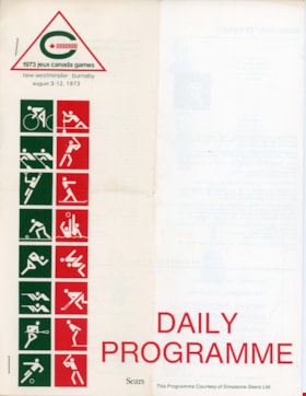
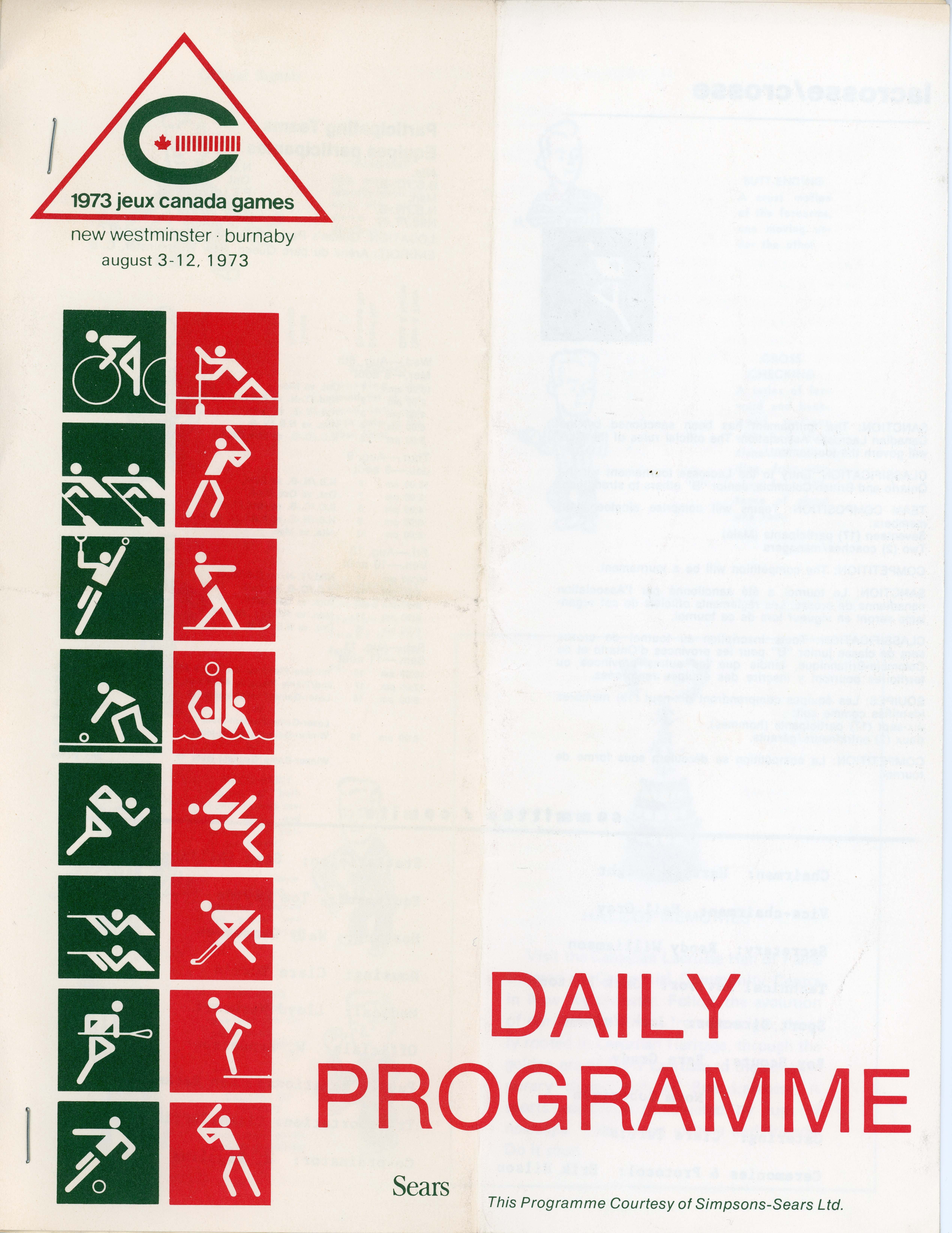
- Daily Programme - Program -- [1973]. Daily program for the Lacrosse games for August 10, 1973 of the 1973 Jeux Canada Games. The program was printed courtesy of Simpsons-Sears Limited. The program gives information about the participating teams and officials signals. The program is staple bound and measures 21.5cm x 28cm.
- Category
- 08. Communication Artifacts
- Classification
- Documentary Artifacts - - Other Documents
- Object Term
- Pamphlet
- Names
- Canada Summer Games
Images
timetable
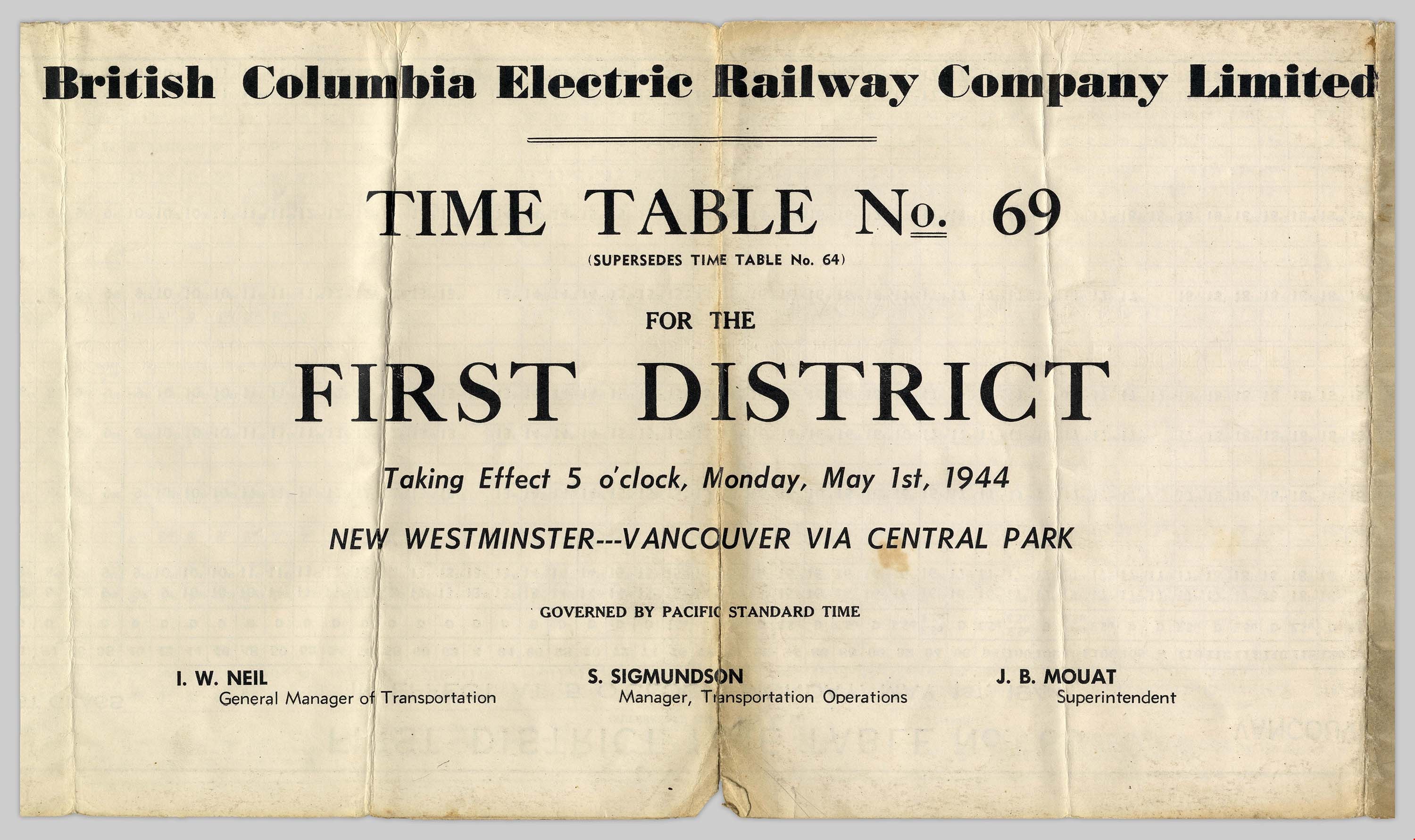
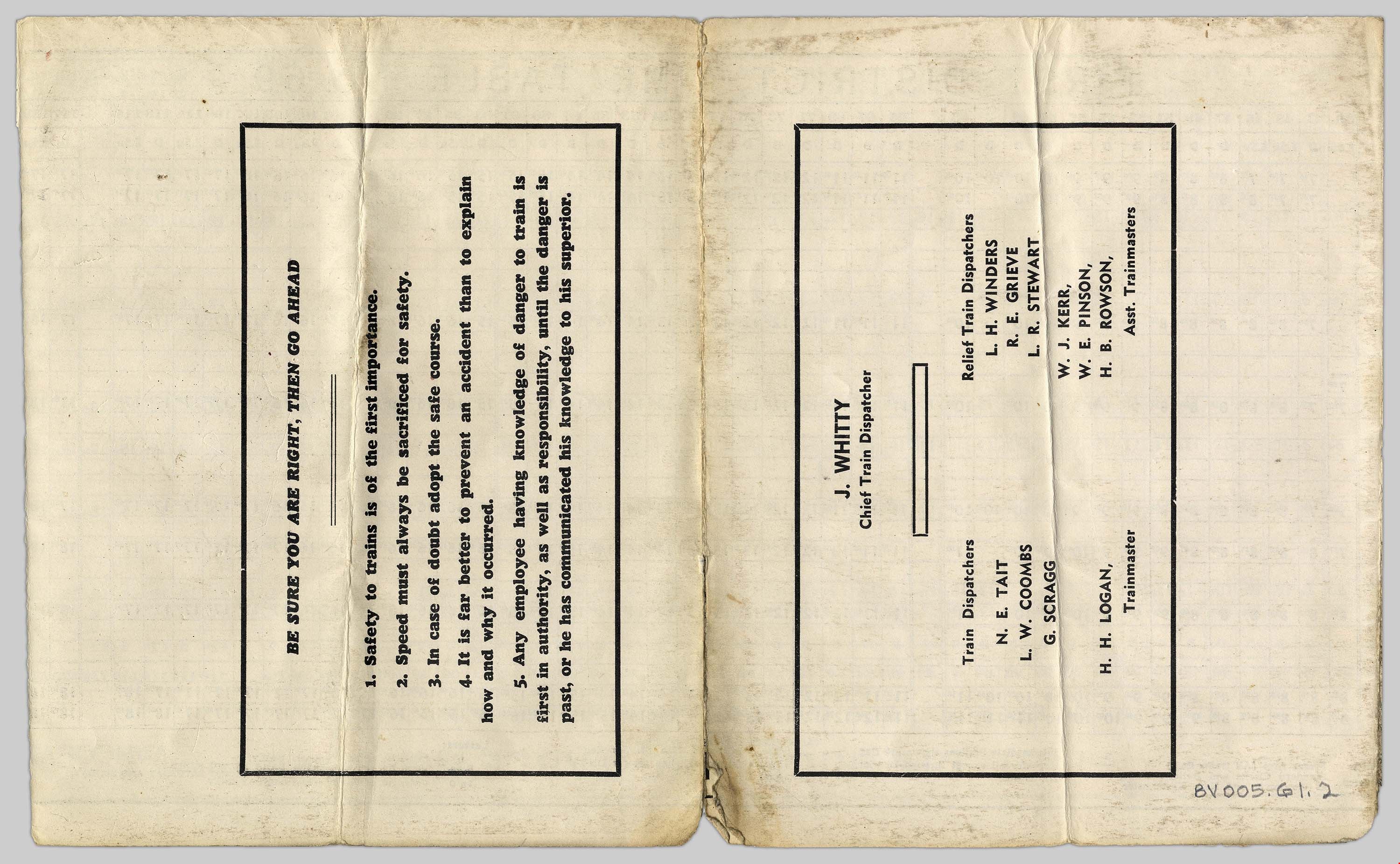
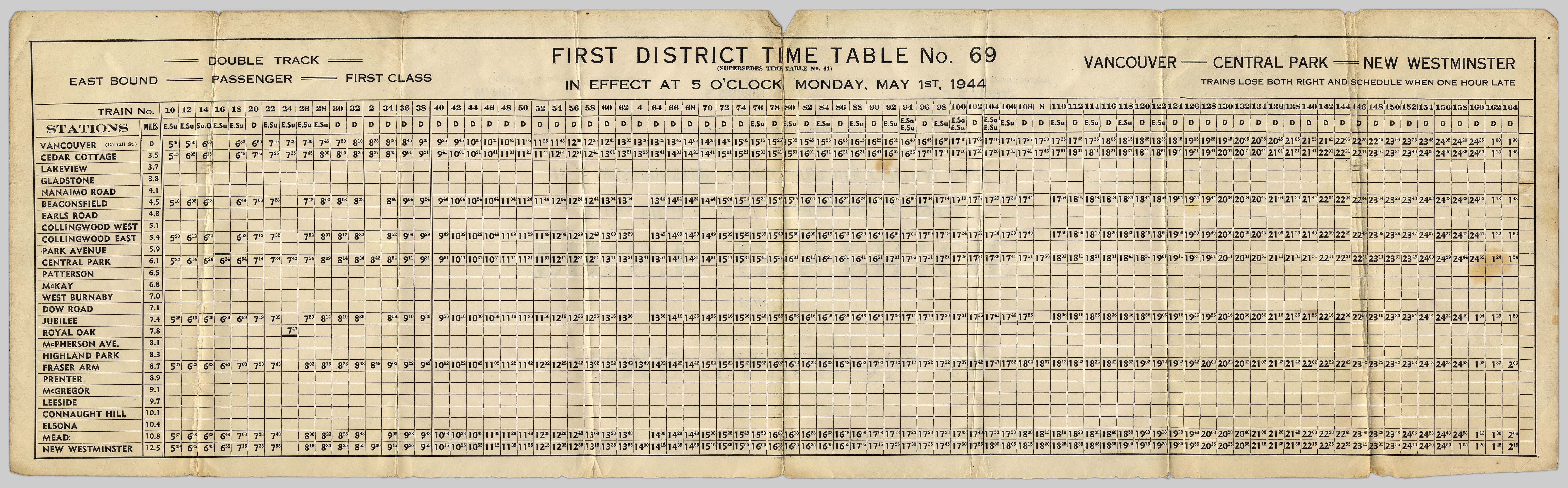
https://search.heritageburnaby.ca/link/museumartifact48959
- Repository
- Burnaby Village Museum
- Accession Code
- BV005.61.2
- Description
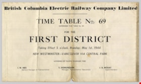
- Timetable, for Central Park B.C.E.R. line; "First District Time Table No.69" "Vancouver-Central Park-New Westminster" "in effect at 5 o'clock Monday, May 1st, 1944"; on obverse, "British Columbia Electric Railway Company Limited" "Time Table No.69", names of company officials, train dispatchers, trainmasters, safety rules; paper discoloured and torn [NOTE in file folder in AB105 reads "used in Tram Exhibit May 4/06]
- Object History
- The donor's father who worked for the B.C.E.R. on trams, as conductor, freight trains, and was later transferred to the gas plant.
- Marks/Labels
- First District Time Table No.69 / Vancouver-Central Park-New Westminster / in effect at 5 o'clock Monday, May 1st, 1944 / British Columbia Electric Railway Company Limited
- Subjects
- Transportation - Electric Railroads
Images