Narrow Results By
Decade
- 2020s 90
- 2010s 220
- 2000s 356
- 1990s 541
- 1980s 578
- 1970s 1265
- 1960s 593
- 1950s
- 1940s 381
- 1930s 355
- 1920s 539
- 1910s
- 1900s 136
- 1890s 71
- 1880s 26
- 1870s 9
- 1860s 20
- 1850s 8
- 1840s 4
- 1830s 2
- 1820s 2
- 1810s 3
- 1800s 3
- 1790s 3
- 1780s 3
- 1770s 3
- 1760s 3
- 1750s 3
- 1740s 3
- 1730s 3
- 1720s 3
- 1710s 3
- 1700s 3
- 1690s 3
- 1680s 3
- 1670s 2
- 1660s 2
- 1650s 2
- 1640s 2
- 1630s 2
- 1620s 2
- 1610s 2
- 1600s 2
- 1590s 1
- 1580s 1
- 1570s 1
- 1560s 1
- 1550s 1
- 1540s 1
- 1530s 1
- 1520s 2
- 1510s 1
- 1500s 1
- 1490s 1
- 1480s 1
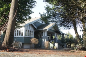
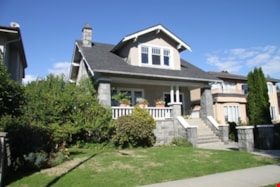
Captain William Eyres Residence
https://search.heritageburnaby.ca/link/landmark565
- Repository
- Burnaby Heritage Planning
- Description
- Residential building.
- Associated Dates
- c.1910
- Street View URL
- Google Maps Street View
- Repository
- Burnaby Heritage Planning
- Geographic Access
- Canada Way
- Associated Dates
- c.1910
- Description
- Residential building.
- Heritage Value
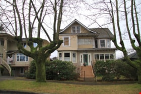
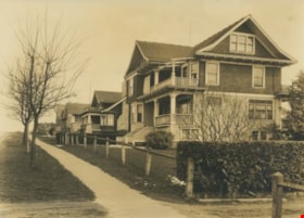
- This home was built by Captain William J. Eyres. In 1912, it was reported in The British Columbian: “Captain Eyres of Seattle is remodelling the front of his house on Douglas Road and otherwise improving it.” The house was later sold to William A. Mawhinney, who subsequently built houses at 6011 Buckingham Avenue and 7616 Burris Avenue. This spacious, high-quality Craftsman bungalow remains in excellent condition. It features a cross-gabled roof with multiple half-timbered front gables with large exposed purlins, in contrast to the shingle cladding on the rest of the house. At the front corner is a glazed sun-room. The entrance porch features tripled square columns. The property still has a beautiful garden, but once included large vegetable gardens, an orchard, and a large chicken house.
- Locality
- Burnaby Lake
- Historic Neighbourhood
- Burnaby Lake (Historic Neighbourhood)
- Planning Study Area
- Morley-Buckingham Area
- Area
- 1709.65
- Contributing Resource
- Building
- Ownership
- Private
- Street Address
- 6079 Canada Way
- Street View URL
- Google Maps Street View
Images
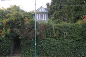
Geoffrey & Kathleen Burnett Residence
https://search.heritageburnaby.ca/link/landmark582
- Repository
- Burnaby Heritage Planning
- Description
- Residential building.
- Associated Dates
- 1914
- Formal Recognition
- Heritage Designation, Community Heritage Register
- Street View URL
- Google Maps Street View
- Repository
- Burnaby Heritage Planning
- Geographic Access
- Canada Way
- Associated Dates
- 1914
- Formal Recognition
- Heritage Designation, Community Heritage Register
- Enactment Type
- Bylaw No. 13841
- Enactment Date
- 28/05/2018
- Description
- Residential building.
- Heritage Value
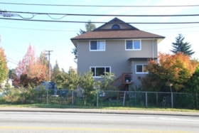
- With its long, narrow plan and hipped, cross-gabled roof, this impressive residence was designed for local surveyor and civil engineer Geoffrey Kirby Burnett, who married Kathleen Wallen (1888-1978) in 1916. It was designed by New Westminster architects R.W. Coventry Dick & Son. Beautifully conceived in the British Arts and Crafts style, it features a steeply-gabled roof over the side entry porch, with square timber columns. Other decorative details include half timbering in the gables, first storey casement windows with leaded transom lights and decorative window hoods on the side elevation.
- Locality
- Edmonds
- Historic Neighbourhood
- Edmonds (Historic Neighbourhood)
- Planning Study Area
- Richmond Park Area
- Architect
- R.W. Coventry Dick & Son
- Area
- 903.70
- Contributing Resource
- Building
- Ownership
- Private
- Street Address
- 7037 Canada Way
- Street View URL
- Google Maps Street View
Images
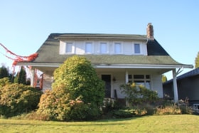
Lonsdale Guardhouse Residence
https://search.heritageburnaby.ca/link/landmark617
- Repository
- Burnaby Heritage Planning
- Description
- Residential building.
- Associated Dates
- 1914
- Street View URL
- Google Maps Street View
- Repository
- Burnaby Heritage Planning
- Geographic Access
- Canada Way
- Associated Dates
- 1914
- Description
- Residential building.
- Heritage Value
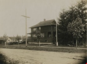
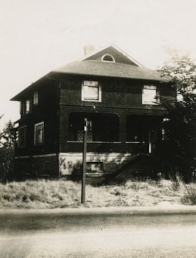
- The house was built by Lonsdale L. Guardhouse, who was employed with the real estate company of Merithew & Ramsay in 1912. The British Columbian reported in November 1913 that: "Mr. L.L. Guardhouse, a well-known New Westminster man has recently let the contract for a home on Douglas Road near Edmonds Street. This Building is to be erected after the bungalow style and will cost when completed about $4,000." This Craftsman style pattern-book residence is notable for its unusual roofline, which features gently curved eaves. The house remains in excellent original condition and retains its lapped and shingled siding. Other notable features of the house include its pre-cast concrete block foundation–simulated to look like cut stone–and a rustic red-brick chimney. The front verandah has been altered through the removal of its floor structure. Many houses at the time were built from Craftsman-style pattern book designs, which were readily available in magazines and brochures. This house has a twin located in New Westminster at 315 Fifth Avenue.
- Locality
- Edmonds
- Historic Neighbourhood
- Edmonds (Historic Neighbourhood)
- Planning Study Area
- Richmond Park Area
- Area
- 828.85
- Contributing Resource
- Building
- Ownership
- Private
- Street Address
- 6985 Canada Way
- Street View URL
- Google Maps Street View
Images
Burnaby Municipal Hall
https://search.heritageburnaby.ca/link/landmark807
- Repository
- Burnaby Heritage Planning
- Geographic Access
- Canada Way
- Associated Dates
- 1956
- Heritage Value
- When staff outgrew the municipal buildings at Edmonds and Kingsway, a debate erupted over where to build a new municipal hall. North Burnaby residents argued against the Kingsway and Edmonds site as it was too removed for their needs, but South Burnaby residents were not prepared to accept a hall in North Burnaby. The debate was finally resolved when it was suggested that the new civic centre for the municipality be in the exact geographic centre of Burnaby. Fortunately, this meant that the new hall was to be built near Deer Lake, in the beautiful Central Valley setting. Burnaby voters accepted this decision and approved the $625,000.00 it would take to build the new structure and the official opening ceremony was held June 22, 1956 when then Reeve Charles MacSorley received the keys to the hall from the contractor.
- Historic Neighbourhood
- Burnaby Lake (Historic Neighbourhood)
- Planning Study Area
- Douglas-Gilpin Area
- Street Address
- 4949 Canada Way
- Street View URL
- Google Maps Street View
Images
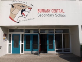
Burnaby Central School
https://search.heritageburnaby.ca/link/landmark814
- Repository
- Burnaby Heritage Planning
- Geographic Access
- Canada Way
- Associated Dates
- 1958
- Heritage Value
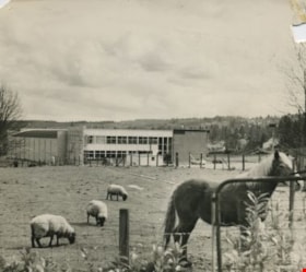
- Burnaby Central School became the third high school to be built in Burnaby (following Burnaby North and Burnaby South). The increased school enrolments due to the rapidly growing population in Burnaby meant that the School District required this third high school to be placed between the other two. In its first year, 719 students attended Burnaby Central.
- Historic Neighbourhood
- Burnaby Lake (Historic Neighbourhood)
- Planning Study Area
- Douglas-Gilpin Area
- Street Address
- 4939 Canada Way
- Street View URL
- Google Maps Street View
Images
Burnaby Winter Club
https://search.heritageburnaby.ca/link/landmark816
- Repository
- Burnaby Heritage Planning
- Geographic Access
- Canada Way
- Associated Dates
- 1956
- Heritage Value
- Skating on Deer Lake and Burnaby Lake was the inspiration to form the Burnaby Winter Club in the 1950s. In 1958, the volunteer group opened an indoor ice facility, still operating today at 4990 Canada Way. Originally, the facility boasted 8 sheets of curling ice, that were used to capacity by the more than 500 family and individual members in the heyday of the Club. The Winter Club was a social centre: in addition to curling, it was a popular place for banquets and dances, and a place for families to spend time together. In the 1960s, the eight sheets of curling ice were reduced to five, to make room for a sheet of hockey ice for the members’ children. Volunteer coaches were committed to excellence, and the Club produced many professional hockey players. By 1964, the Club’s first future NHL player was playing: Pee Wee player Jack McIlhargey.
- Historic Neighbourhood
- Burnaby Lake (Historic Neighbourhood)
- Planning Study Area
- Douglas-Gilpin Area
- Street Address
- 4990 Canada Way
- Street View URL
- Google Maps Street View
Images
Who's who in western Canada : a bibliographical dictionary of notable living men and women of western Canada, volume 1
https://search.heritageburnaby.ca/link/museumlibrary1820
- Repository
- Burnaby Village Museum
- Collection
- Special Collection
- Material Type
- Book
- Accession Code
- HV983.61.2
- Call Number
- 920 WHO
- Contributor
- Parker, C. W. (Charles Wallace), 1864-1932
- Place of Publication
- Vancouver
- Publisher
- Canadian Press Association
- Publication Date
- 1911
- Physical Description
- 390 p. : ill., ports. ; 20 cm.
- Inscription
- "Presented to Burnaby Historical Society _______ B Brown __M_ Burnaby 1932 to 1959" [handwritten in blue ink on front endpaper]
- Library Subject (LOC)
- Canada
- Dictionaries
- Biography
- Notes
- "Edited by C.W. Parker" --title page
Who's who in western Canada : a bibliographical dictionary of notable living men and women of western Canada
https://search.heritageburnaby.ca/link/museumlibrary3393
- Repository
- Burnaby Village Museum
- Collection
- Special Collection
- Material Type
- Book
- Accession Code
- BV993.12.3
- Call Number
- 920 WHO
- Contributor
- Parker, C. W. (Charles Wallace), 1864-1932
- Place of Publication
- Vancouver
- Publisher
- Canadian Press Association
- Publication Date
- 1911
- Physical Description
- 390 p. : ill., ports. ; 20 cm.
- Library Subject (LOC)
- Canada
- Dictionaries
- Biography
- Notes
- "Edited by C.W. Parker" --t.p.
Excursions in northern British Columbia and Yukon Territory and along the North Pacific Coast : excursions C8 and C9; no.10
https://search.heritageburnaby.ca/link/museumlibrary537
- Repository
- Burnaby Village Museum
- Collection
- Special Collection
- Material Type
- Book
- Accession Code
- BV986.53.45
- Call Number
- 557.1 GSC
- Place of Publication
- Ottawa
- Publisher
- Government Printing Bureau
- Publication Date
- 1913
- Physical Description
- 179 p. : ill., maps (some folded) ; 20 cm.
- Inscription
- Stamped inside: "Kennco Library"
- Library Subject (LOC)
- Geology--British Columbia
- Geology--Yukon
- British Columbia--Description and travel
- Canada, Western--Description and travel
- Yukon--Description and travel
- Notes
- "Excursions C8 and C9."
- Six maps on folded leaves in pocket.
- Includes bibliographies.
The Labrador Eskimo, no. 1637
https://search.heritageburnaby.ca/link/museumlibrary1998
- Repository
- Burnaby Village Museum
- Collection
- Special Collection
- Material Type
- Book
- Accession Code
- HV980.2.13
- Call Number
- 970.4 HAW
- Place of Publication
- Ottawa
- Publisher
- Government Printing Bureau
- Publication Date
- 1916
- Physical Description
- x, 235 p., viii : ill., map ; 25 cm.
- Library Subject (LOC)
- Inuit--Newfoundland and Labrador--Labrador
- Inuit--Quebec (Province)
- Notes
- At head of title: Canada, Department of Mines, Geological Survey
- "No. 1637"
Motor Vehicle Mechanic
https://search.heritageburnaby.ca/link/museumlibrary7530
- Repository
- Burnaby Village Museum
- Publication Date
- c1956
- Repository
- Burnaby Village Museum
- Collection
- Special Collection
- Material Type
- Photograph
- Accession Code
- BV016.7.4
- Contributor
- Cabeldu Motors Limited
- L'Ecole de L'Automobile de Montreal Technical High School
- Myers Motors
- General Motors of Canada
- Anders, Fred
- Buccino, Fred
- Lund, Chris
- O'Connor, Hugh
- Place of Publication
- Ottawa
- Publisher
- National Film Board of Canada
- Publication Date
- c1956
- Physical Description
- 39 photographs : filmstrip ; cellulose aacetate, b&w pos.
- Library Subject (LOC)
- Documentary Films
- Filmstrips
- Automobiles--Maintenance and repair
- Automobiles--Motors
- Object History
- Came in with Oakalla Prison records and artifacts in 1991. Filmstrip was utilized by staff and inmates of Oakalla. Digitized by BVM into preservation and accessible formats in 2020.
- Notes
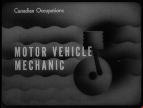
- Filmstrip (photographs and illustrations with subtitles) provides a brief synopsis of apprenticeship training for a motor vehicle mechanic. Segments include "Motor Vehicle Mechanic"; "Related Fields of Training"; "Opportunities in the Trade". Film was created in collaboration with the Occupational Analysis Section of the Department of Labour. Film frame 36 reads: "For further information... read Monograph No. 10 in the "Canadian Occupations" series, consult your local National Employment Service office, teachers, counsellors and person familiar with the automobile trades." Accompanying sound recording is missing.
Images
Documents
Central Park Entrance Gate
https://search.heritageburnaby.ca/link/landmark544
- Repository
- Burnaby Heritage Planning
- Description
- The Central Park Entrance Gate is the ceremonial entrance to Burnaby’s historic Central Park from Kingsway, and consists of two massive stone pillars, approximately 7.5 metres high and 1.8 metres square, adjacent gate posts and a low flanking stone wall that curves into the park to the east.
- Associated Dates
- 1913
- Formal Recognition
- Heritage Designation, Community Heritage Register
- Street View URL
- Google Maps Street View
- Repository
- Burnaby Heritage Planning
- Geographic Access
- Imperial Street
- Associated Dates
- 1913
- Formal Recognition
- Heritage Designation, Community Heritage Register
- Enactment Type
- Bylaw No. 9807
- Enactment Date
- 23/11/1992
- Description
- The Central Park Entrance Gate is the ceremonial entrance to Burnaby’s historic Central Park from Kingsway, and consists of two massive stone pillars, approximately 7.5 metres high and 1.8 metres square, adjacent gate posts and a low flanking stone wall that curves into the park to the east.
- Heritage Value
- The Central Park Entrance Gate is significant as a ceremonial entry to a major park, for its connection with the early history of the British Columbia Electric Railway (BCER) and as an important design by an accomplished British Columbian architect. When the original interurban line between Vancouver and New Westminster was constructed in 1891, one of the first stations was located where the tramway crossed the Vancouver-Westminster Road (now Kingsway) within the newly-created Central Park. The interurban line ran through the park on a diagonal right-of-way (the current SkyTrain line, opened in 1986, follows this original alignment). In 1912 an agreement was reached between the successor interurban company, the BCER, and the Central Park Provincial Park Board, to deed additional land for an expanded right-of-way through the Park in exchange for improvements that included the construction of an ornamental stone wall and gate with an iron arch, with an illuminated 'Central Park' sign, adjacent to the interurban station on Kingsway. This was an early and rare example of an electric sign used for a public recreation facility. The Gate is also significant as a surviving early design by Robert Lyon (1879-1963), an Edinburgh-born and trained immigrant who was one of the most accomplished of British Columbia's early architects. After he moved to Vancouver, he was employed by the BCER from 1911 until 1918, and worked on a broad range of projects including some of the grandest and most innovative local industrial structures of the time. The arch was built by the Westminster Ironworks Company, one of the leading firms of its kind in Western Canada, operated by John Reid of New Westminster. The Gate was completed in 1914; in 1968 the decorative ironwork was removed due to corrosion and placed in storage.
- Defining Elements
- Key elements that define the heritage character of the Central Park Entrance Gate include its: - two subtly tapered massive stone pillars, which rise in stages from a larger base to a shaft with random coursed multi-coloured granite with roughly formed grey granite quoins, to a top formed of finely finished grey granite blocks with a coved and bracketed cap - adjacent gate posts with monolithic pyramidal granite caps - low flanking stone wall that curves into the park to the east, constructed of random coursed multi-coloured granite with a river rock triangular cap
- Historic Neighbourhood
- Central Park (Historic Neighbourhood)
- Planning Study Area
- Maywood Area
- Architect
- Robert Lyon
- Builder
- John Reid
- Westminster Iron Works Co.
- Function
- Primary Current--Park Fixture
- Primary Historic--Park Fixture
- Community
- Burnaby
- Cadastral Identifier
- P.I.D. No. 017-767-172 Legal Description: Block B of Lot 2 Except Firstly: Part on Plan 8669 and Secondly: Part on Plan LMP4689 District Lot 151, Group 1, New Westminster District, Plan 3443
- Boundaries
- The property (Central Park) is a municipally-owned park that lies at the western edge of Burnaby, between 49th Avenue to the south, Kingsway to the north, Boundary Road to the west and Patterson Avenue to the east.
- Area
- 853,403.82
- Contributing Resource
- Structure
- Landscape Feature
- Ownership
- Public (local)
- Names
- Lyon, Robert
- Reid, John
- Westminster Iron Works Company
- British Columbia Electric Railway Company
- Central Park Provincial Park Board
- Subjects
- Structures - Fences
- Street Address
- 3883 Imperial Street
- Street View URL
- Google Maps Street View
Images
Harrison & Beatrice Morrison Residence
https://search.heritageburnaby.ca/link/landmark589
- Repository
- Burnaby Heritage Planning
- Description
- Residential building.
- Associated Dates
- 1911
- Street View URL
- Google Maps Street View
- Repository
- Burnaby Heritage Planning
- Geographic Access
- Dundas Street
- Associated Dates
- 1911
- Description
- Residential building.
- Heritage Value
- In 1911, the Vancouver Daily Province reported that “Mr. Harrison D. Morrison is building a twelve-room house of two stories and an attic, with stone basement, on Dundas Street, at a cost of about $4,500.” Harrison Donald Morrison (1864-1944) was a life-long contractor who lived in Burnaby with his wife Beatrice Amanda (née Smith, 1875-1954), until his death in 1944. This Edwardian-era house displays many holdover elements of the Queen Anne Revival style, particularly the elaboration of wall surfaces. In this example, the use of bay and cutaway bay windows, and integral first and second storey verandahs–now removed or altered–add visual interest. The distinct dual pitch of the roof is also a transitional characteristic, used in the late days of the Queen Anne Revival style. A later coat of stucco now covers the original ground floor siding.
- Locality
- Vancouver Heights
- Historic Neighbourhood
- Vancouver Heights (Historic Neighbourhood)
- Planning Study Area
- Burnaby Heights Area
- Area
- 566.71
- Contributing Resource
- Building
- Ownership
- Private
- Street Address
- 3738 Dundas Street
- Street View URL
- Google Maps Street View
Images
Peter & Alma Newstrom Residence
https://search.heritageburnaby.ca/link/landmark631
- Repository
- Burnaby Heritage Planning
- Description
- Residential building.
- Associated Dates
- c.1915
- Street View URL
- Google Maps Street View
- Repository
- Burnaby Heritage Planning
- Geographic Access
- Oxford Street
- Associated Dates
- c.1915
- Description
- Residential building.
- Heritage Value
- This bungalow was built and owned by Peter John Newstrom (1861-1947), who later worked as a bricklayer, and his wife Alma Mary (1865-1935). The Newstroms arrived in Canada from Sweden about 1912 and were long-term residents of this home; Peter lived in the house after the death of his wife, until his own death in 1947. Typical of the Craftsman style, the house has a side gabled roof with large front gabled dormer, scroll-cut bargeboards, open front verandah and granite rubble-stone foundation and tapered piers. It retains its original glazed front door assembly.
- Locality
- Vancouver Heights
- Historic Neighbourhood
- Vancouver Heights (Historic Neighbourhood)
- Planning Study Area
- Burnaby Heights Area
- Area
- 566.71
- Contributing Resource
- Building
- Ownership
- Private
- Street Address
- 3865 Oxford Street
- Street View URL
- Google Maps Street View
Images
Thomas & Margaret Coldicutt Residence
https://search.heritageburnaby.ca/link/landmark647
- Repository
- Burnaby Heritage Planning
- Description
- Residential building.
- Associated Dates
- 1911
- Street View URL
- Google Maps Street View
- Repository
- Burnaby Heritage Planning
- Geographic Access
- 6th Street
- Associated Dates
- 1911
- Description
- Residential building.
- Heritage Value
- This house was built by Thomas Davis Coldicutt (1879-1970) and Margaret Jane Coldicutt, pre-eminent local citizens. Thomas Coldicutt was born in Birmingham and arrived in Canada in 1900, finding success in the steamboat industry. In 1902, he married Margaret Jane Styler who had been born in Redditch, Worcester, England, and in 1908 they settled in East Burnaby–some of the first pioneers to the area–and established a fruit farm. Thomas had a successful real estate, insurance and brokerage business, and was elected as a councillor for East Burnaby in 1909. He was also active in civic, political and social circles in Burnaby and became president of the Burnaby Board of Trade. "East Burnaby is booming and the signs of prosperity that may be seen on every hand. Most of these are substantial dwellings, such as effect a permanent improvement to the countryside. Among those whose homes have been completed, or on the point of completion may be mentioned. Councillor Coldicutt, who has built himself a habitation on Second Avenue at a cost of $4,000. (The British Columbian, 1911). In 1913, Coldicutt sold his original farm described as “the show place of Burnaby” to the Burnaby School Board for the development of Second Street School and this house was moved from Second Street and Sixteenth Avenue to this site. It has been extensively altered, but retains its original form, scale and massing.
- Locality
- East Burnaby
- Historic Neighbourhood
- East Burnaby (Historic Neighbourhood)
- Planning Study Area
- Edmonds Area
- Area
- 557.42
- Contributing Resource
- Building
- Ownership
- Private
- Street Address
- 7510 6th Street
- Street View URL
- Google Maps Street View
Images
Willingdon Heights Neighbourhood
https://search.heritageburnaby.ca/link/landmark670
- Repository
- Burnaby Heritage Planning
- Associated Dates
- 1925-1954
- Heritage Value
- Willingdon Heights was another new subdivision developed in Burnaby during the post-World War Two building boom. A brochure about the development published in 1948 proclaimed "the Willingdon Heights 500 home development project in Burnaby fulfills its promise to provide a self-contained community for former members of the armed services and their families...the largest single veteran housing project in Canada as far as homes for individual ownership is concerned, Willingdon Heights development was planned by the Central Mortgage and Housing Corporation...At this date the earlier built rows of homes have passable roads and the owners are improving lawns and gardens in spare time...eventually additional stores and professional services will be installed and recreational projects will add to the amenities of a community of congenial residents..."
- Planning Study Area
- Willingdon Heights Area
Images
Trans Mountain Pipeline Company
https://search.heritageburnaby.ca/link/landmark685
- Repository
- Burnaby Heritage Planning
- Geographic Access
- Shellmont Street
- Associated Dates
- 1953
- Heritage Value
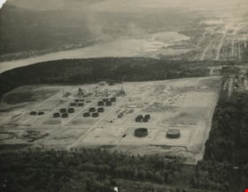
- On March 21, 1951 the Parliament of Canada granted the Trans Mountain Oil Pipe Line Company a charter. By May of the following year, the Corporation of Burnaby gave final reading to Bylaw No. 3203, which resulted in the conveyance of land in DL 142, 143 and 144 (Burnaby Mountain site) to the Trans Mountain Oil Pipe Line Company. Construction of the Burnaby Mountain tank farm was completed in October of 1953 and the site became operational as the first shipment of oil reached Trans Mountain’s Burnaby Terminal.
- Planning Study Area
- Lake City Area
- Street Address
- 8099 Shellmont Street
- Street View URL
- Google Maps Street View
Images
Simpson-Sears
https://search.heritageburnaby.ca/link/landmark696
- Repository
- Burnaby Heritage Planning
- Geographic Access
- Kingsway
- Associated Dates
- 1954
- Heritage Value
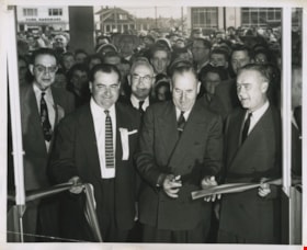
- The Simpson-Sears store on Kingsway opened in 1954 and was the second Simpson-Sears to be located in British Columbia. The store helped to solidify the neighbourhood's growing reputation as a major commercial centre in the Lower Mainland and became a prototype for the company's large format stores across Canada.
- Historic Neighbourhood
- Central Park (Historic Neighbourhood)
- Planning Study Area
- Maywood Area
- Street Address
- 4700 Kingsway
Images
Sperling Avenue School
https://search.heritageburnaby.ca/link/landmark744
- Repository
- Burnaby Heritage Planning
- Geographic Access
- Sperling Avenue
- Associated Dates
- 1914
- Heritage Value
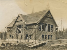
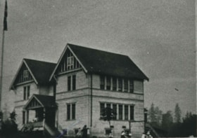
- The Sperling Avenue School was opened in 1914 to service the growing community around the B.C. Electric Company's Pole Line Road (Sperling Avenue). This school replaced the one-room Duthie schoolhouse.
- Historic Neighbourhood
- Lochdale (Historic Neighbourhood)
- Planning Study Area
- Sperling-Broadway Area
- Street Address
- 2200 Sperling Avenue
- Street View URL
- Google Maps Street View
Images
Inman Avenue School
https://search.heritageburnaby.ca/link/landmark753
- Repository
- Burnaby Heritage Planning
- Geographic Access
- Brandon Street
- Associated Dates
- 1911
- Heritage Value
- The Inman Avenue school was built in 1912. The original four-room building was expanded in 1923 and an additional four rooms were constructed. In the mid-1950s, the current building replaced the older structure.
- Historic Neighbourhood
- Central Park (Historic Neighbourhood)
- Planning Study Area
- Garden Village Area
- Street Address
- 3963 Brandon Street
- Street View URL
- Google Maps Street View
