Narrow Results By
Format
- Book 19
- Bylaws - Adopted
- Bylaws - Repealed
- Council - 7
- Council - Committee Report 605
- Council - Information Report 15
- Council - Manager's Report 846
- Council - Mayor/Councillor/Staff Report 7
- Council - Public Hearing Minutes 27
- Council - Regular Council Minutes 127
- Graphic Material 4
- Landmark Description 1
Subject
- Advertising Medium - Poster 1
- Advertising Medium - Signs and Signboards 57
- Arts - Paintings 1
- Buildings - Civic - Hospitals 6
- Buildings - Civic - Libraries 1
- Buildings - Civic - Museums 5
- Buildings - Commercial 5
- Buildings - Commercial - Drugstores 1
- Buildings - Commercial - Grocery Stores 12
- Buildings - Commercial - Malls 2
- Buildings - Commercial - Offices 1
- Buildings - Commercial - Restaurants 4

3955 Moscrop Street
https://search.heritageburnaby.ca/link/archivedescription98654
- Repository
- City of Burnaby Archives
- Date
- 2021
- Collection/Fonds
- Disappearing Burnaby collection
- Description Level
- Item
- Physical Description
- 1 photograph (jpeg) : col.
- Scope and Content
- Photograph of the exterior of a house located at 3955 Moscrop Street. The house was constructed in 1954. The photograph depicts the house at night, with the house's porch light on, and a car is in the driveway in front of the house.
- Repository
- City of Burnaby Archives
- Date
- 2021
- Collection/Fonds
- Disappearing Burnaby collection
- Physical Description
- 1 photograph (jpeg) : col.
- Description Level
- Item
- Record No.
- 634-001
- Access Restriction
- No restrictions
- Reproduction Restriction
- No restrictions
- Accession Number
- 2022-14
- Scope and Content
- Photograph of the exterior of a house located at 3955 Moscrop Street. The house was constructed in 1954. The photograph depicts the house at night, with the house's porch light on, and a car is in the driveway in front of the house.
- Media Type
- Photograph
- Photographer
- Cheung, Nakita
- Notes
- Title taken from the associated blog post
- Associated blog post: https://disappearingburnaby.wordpress.com/2022/02/24/moscrop-house/
- Geographic Access
- Moscrop Street
- Street Address
- 3955 Moscrop Street
- Historic Neighbourhood
- Broadview (Historic Neighbourhood)
- Planning Study Area
- Cascade-Schou Area
Images


5130 Irving Street
https://search.heritageburnaby.ca/link/archivedescription98671
- Repository
- City of Burnaby Archives
- Date
- 2022
- Collection/Fonds
- Disappearing Burnaby collection
- Description Level
- Item
- Physical Description
- 1 photograph (jpeg) : col.
- Scope and Content
- Photograph of the front steps and the entrance of a three-storey apartment building located at 5130 Irving Street. The photograph depicts the building at night, with the lobby and some of the apartments' windows illuminated from inside. The building was constructed in 1971.
- Repository
- City of Burnaby Archives
- Date
- 2022
- Collection/Fonds
- Disappearing Burnaby collection
- Physical Description
- 1 photograph (jpeg) : col.
- Description Level
- Item
- Record No.
- 634-018
- Access Restriction
- No restrictions
- Reproduction Restriction
- No restrictions
- Accession Number
- 2022-14
- Scope and Content
- Photograph of the front steps and the entrance of a three-storey apartment building located at 5130 Irving Street. The photograph depicts the building at night, with the lobby and some of the apartments' windows illuminated from inside. The building was constructed in 1971.
- Media Type
- Photograph
- Photographer
- Cheung, Nakita
- Notes
- Title taken from the associated blog post
- Associated blog post: https://disappearingburnaby.wordpress.com/2022/05/04/e-just-e/
- Geographic Access
- Irving Street
- Street Address
- 5130 Irving Street
- Historic Neighbourhood
- Central Park (Historic Neighbourhood)
- Planning Study Area
- Marlborough Area
Images


5130 Irving Street lobby
https://search.heritageburnaby.ca/link/archivedescription98672
- Repository
- City of Burnaby Archives
- Date
- 2022
- Collection/Fonds
- Disappearing Burnaby collection
- Description Level
- Item
- Physical Description
- 1 photograph (jpeg) : col.
- Scope and Content
- Photograph of the entrance of an apartment building located at 5130 Irving Street. The building was constructed in 1971. The photograph depicts the entrance and the lobby from the exterior at night. The lobby is illuminated and a crest featuring an "E" is on the entrance window.
- Repository
- City of Burnaby Archives
- Date
- 2022
- Collection/Fonds
- Disappearing Burnaby collection
- Physical Description
- 1 photograph (jpeg) : col.
- Description Level
- Item
- Record No.
- 634-019
- Access Restriction
- No restrictions
- Reproduction Restriction
- No restrictions
- Accession Number
- 2022-14
- Scope and Content
- Photograph of the entrance of an apartment building located at 5130 Irving Street. The building was constructed in 1971. The photograph depicts the entrance and the lobby from the exterior at night. The lobby is illuminated and a crest featuring an "E" is on the entrance window.
- Media Type
- Photograph
- Photographer
- Cheung, Nakita
- Notes
- Title taken from the associated blog post
- Associated blog post: https://disappearingburnaby.wordpress.com/2022/05/04/e-just-e/
- Geographic Access
- Irving Street
- Street Address
- 5130 Irving Street
- Historic Neighbourhood
- Central Park (Historic Neighbourhood)
- Planning Study Area
- Marlborough Area
Images


5990 Irmin Street
https://search.heritageburnaby.ca/link/archivedescription98685
- Repository
- City of Burnaby Archives
- Date
- 2022
- Collection/Fonds
- Disappearing Burnaby collection
- Description Level
- Item
- Physical Description
- 1 photograph (jpeg) : col.
- Scope and Content
- Photograph of a multi-storey house located at 5990 Irmin Street. The photograph depicts of the exterior of the house at dusk; a light is on in one of the house's rooms and a vehicle is parked in the house's driveway next to a portable garage. A "For Sale" sign on the edge of the property reads: "Fu…
- Repository
- City of Burnaby Archives
- Date
- 2022
- Collection/Fonds
- Disappearing Burnaby collection
- Physical Description
- 1 photograph (jpeg) : col.
- Description Level
- Item
- Record No.
- 634-032
- Access Restriction
- No restrictions
- Reproduction Restriction
- No restrictions
- Accession Number
- 2022-14
- Scope and Content
- Photograph of a multi-storey house located at 5990 Irmin Street. The photograph depicts of the exterior of the house at dusk; a light is on in one of the house's rooms and a vehicle is parked in the house's driveway next to a portable garage. A "For Sale" sign on the edge of the property reads: "Future Development Land." Another house is visible in the background. The house was constructed in 1923 and is nearby to 7530 Buller Avenue.
- Media Type
- Photograph
- Photographer
- Cheung, Nakita
- Notes
- Title taken from the associated blog post
- Associated blog post: https://disappearingburnaby.wordpress.com/2022/06/30/william-esther-burdick-residence/
- Geographic Access
- Irmin Street
- Street Address
- 5990 Irmin Street
- Historic Neighbourhood
- Alta Vista (Historic Neighbourhood)
- Planning Study Area
- Clinton-Glenwood Area
Images


6280 Marlborough Avenue
https://search.heritageburnaby.ca/link/archivedescription98673
- Repository
- City of Burnaby Archives
- Date
- 2022
- Collection/Fonds
- Disappearing Burnaby collection
- Description Level
- Item
- Physical Description
- 1 photograph (jpeg) : col.
- Scope and Content
- Photograph of the front steps and entry to a three-storey apartment building, located at 6280 Marlborough Avenue. The photograph depicts the building at night and shows the brick building's details, including its lion statues and busts along the stair railings and the curved arches in front of the …
- Repository
- City of Burnaby Archives
- Date
- 2022
- Collection/Fonds
- Disappearing Burnaby collection
- Physical Description
- 1 photograph (jpeg) : col.
- Description Level
- Item
- Record No.
- 634-020
- Access Restriction
- No restrictions
- Reproduction Restriction
- No restrictions
- Accession Number
- 2022-14
- Scope and Content
- Photograph of the front steps and entry to a three-storey apartment building, located at 6280 Marlborough Avenue. The photograph depicts the building at night and shows the brick building's details, including its lion statues and busts along the stair railings and the curved arches in front of the front windows and door. The building was constructed in 1973.
- Media Type
- Photograph
- Photographer
- Cheung, Nakita
- Notes
- Title taken from the associated blog post
- Associated blog post: https://disappearingburnaby.wordpress.com/2022/05/12/marlborough-ave/
- Geographic Access
- Marlborough Avenue
- Street Address
- 6280 Marlborough Avenue
- Historic Neighbourhood
- Central Park (Historic Neighbourhood)
- Planning Study Area
- Marlborough Area
Images


6410 Denbigh Avenue
https://search.heritageburnaby.ca/link/archivedescription98667
- Repository
- City of Burnaby Archives
- Date
- 2022
- Collection/Fonds
- Disappearing Burnaby collection
- Description Level
- Item
- Physical Description
- 1 photograph (jpeg) : col.
- Scope and Content
- Photograph of the exterior of a single-storey house located at 6410 Denbigh Avenue, taken from across the street at dusk. The house was constructed in 1949. Lights illuminate the front porch and the interior of one of the house's windows and there is a small amount of snow on the lawn in front of t…
- Repository
- City of Burnaby Archives
- Date
- 2022
- Collection/Fonds
- Disappearing Burnaby collection
- Physical Description
- 1 photograph (jpeg) : col.
- Description Level
- Item
- Record No.
- 634-014
- Access Restriction
- No restrictions
- Reproduction Restriction
- No restrictions
- Accession Number
- 2022-14
- Scope and Content
- Photograph of the exterior of a single-storey house located at 6410 Denbigh Avenue, taken from across the street at dusk. The house was constructed in 1949. Lights illuminate the front porch and the interior of one of the house's windows and there is a small amount of snow on the lawn in front of the house.
- Media Type
- Photograph
- Photographer
- Cheung, Nakita
- Notes
- Title taken from the associated blog post
- Associated blog post: https://disappearingburnaby.wordpress.com/2022/05/15/denbigh-ave/
- Geographic Access
- Denbigh Avenue
- Street Address
- 6410 Denbigh Avenue
- Historic Neighbourhood
- Central Park (Historic Neighbourhood)
- Planning Study Area
- Windsor Area
Images


6508 Silver Avenue
https://search.heritageburnaby.ca/link/archivedescription98678
- Repository
- City of Burnaby Archives
- Date
- 2022
- Collection/Fonds
- Disappearing Burnaby collection
- Description Level
- Item
- Physical Description
- 1 photograph (jpeg) : col.
- Scope and Content
- Photograph of the corner and side of the exterior of a concrete low-rise apartment building located at 6508 Silver Avenue. The photograph depicts the building at dusk. Some of the apartment windows are lit up from inside, and plant pots are lined up along the third-floor balcony. A chain link fence…
- Repository
- City of Burnaby Archives
- Date
- 2022
- Collection/Fonds
- Disappearing Burnaby collection
- Physical Description
- 1 photograph (jpeg) : col.
- Description Level
- Item
- Record No.
- 634-025
- Access Restriction
- No restrictions
- Reproduction Restriction
- No restrictions
- Accession Number
- 2022-14
- Scope and Content
- Photograph of the corner and side of the exterior of a concrete low-rise apartment building located at 6508 Silver Avenue. The photograph depicts the building at dusk. Some of the apartment windows are lit up from inside, and plant pots are lined up along the third-floor balcony. A chain link fence surrounds the backyard. The building was constructed in 1966.
- Media Type
- Photograph
- Photographer
- Cheung, Nakita
- Notes
- Title taken from the associated blog post
- Associated blog post: https://disappearingburnaby.wordpress.com/2022/06/30/brutalist/
- Geographic Access
- Silver Avenue
- Street Address
- 6508 Silver Avenue
- Historic Neighbourhood
- Central Park (Historic Neighbourhood)
- Planning Study Area
- Maywood Area
Images


6615 Telford Avenue
https://search.heritageburnaby.ca/link/archivedescription98674
- Repository
- City of Burnaby Archives
- Date
- 2022
- Collection/Fonds
- Disappearing Burnaby collection
- Description Level
- Item
- Physical Description
- 1 photograph (jpeg) : col.
- Scope and Content
- Photograph of the entrance, including the front steps and ramp, to a low-rise apartment building located at 6615 Telford Avenue. The building was constructed in 1964. The photograph depicts the building at night, and trees and bushes partially obscure the entrance. The building's lobby is illuminat…
- Repository
- City of Burnaby Archives
- Date
- 2022
- Collection/Fonds
- Disappearing Burnaby collection
- Physical Description
- 1 photograph (jpeg) : col.
- Description Level
- Item
- Record No.
- 634-021
- Access Restriction
- No restrictions
- Reproduction Restriction
- No restrictions
- Accession Number
- 2022-14
- Scope and Content
- Photograph of the entrance, including the front steps and ramp, to a low-rise apartment building located at 6615 Telford Avenue. The building was constructed in 1964. The photograph depicts the building at night, and trees and bushes partially obscure the entrance. The building's lobby is illuminated and the apartments' mailboxes are visible through the window.
- Media Type
- Photograph
- Photographer
- Cheung, Nakita
- Notes
- Title taken from the associated blog post
- Associated blog post: https://disappearingburnaby.wordpress.com/2022/06/09/martello-group/
- Geographic Access
- Telford Avenue
- Street Address
- 6615 Telford Avenue
- Historic Neighbourhood
- Central Park (Historic Neighbourhood)
- Planning Study Area
- Maywood Area
Images


6692 Dow Avenue
https://search.heritageburnaby.ca/link/archivedescription98662
- Repository
- City of Burnaby Archives
- Date
- 2022
- Collection/Fonds
- Disappearing Burnaby collection
- Description Level
- Item
- Physical Description
- 1 photograph (jpeg) : col.
- Scope and Content
- Photograph of the exterior of a two-storey apartment building located at 6692 Dow Avenue. The photograph depicts the building from across the street at night; the lobby and some of the apartment windows are lit up, with a bunch of balloons in one window, and a car is parked on the street in front o…
- Repository
- City of Burnaby Archives
- Date
- 2022
- Collection/Fonds
- Disappearing Burnaby collection
- Physical Description
- 1 photograph (jpeg) : col.
- Description Level
- Item
- Record No.
- 634-009
- Access Restriction
- No restrictions
- Reproduction Restriction
- No restrictions
- Accession Number
- 2022-14
- Scope and Content
- Photograph of the exterior of a two-storey apartment building located at 6692 Dow Avenue. The photograph depicts the building from across the street at night; the lobby and some of the apartment windows are lit up, with a bunch of balloons in one window, and a car is parked on the street in front of the building. The building was constructed in 1959.
- Media Type
- Photograph
- Photographer
- Cheung, Nakita
- Notes
- Title taken from the associated blog post
- Associated blog post: https://disappearingburnaby.wordpress.com/2022/03/01/dow-ave/
- Geographic Access
- Dow Avenue
- Street Address
- 6692 Dow Avenue
- Historic Neighbourhood
- Central Park (Historic Neighbourhood)
- Planning Study Area
- Maywood Area
Images


6700 Dow Avenue
https://search.heritageburnaby.ca/link/archivedescription98663
- Repository
- City of Burnaby Archives
- Date
- 2022
- Collection/Fonds
- Disappearing Burnaby collection
- Description Level
- Item
- Physical Description
- 1 photograph (jpeg) : col.
- Scope and Content
- Photograph of the entrance to an apartment building located at 6700 Dow Avenue. The photograph depicts the building at night; the lobby and stairs are illuminated by exterior and interior lights. The building was constructed in 1968.
- Repository
- City of Burnaby Archives
- Date
- 2022
- Collection/Fonds
- Disappearing Burnaby collection
- Physical Description
- 1 photograph (jpeg) : col.
- Description Level
- Item
- Record No.
- 634-010
- Access Restriction
- No restrictions
- Reproduction Restriction
- No restrictions
- Accession Number
- 2022-14
- Scope and Content
- Photograph of the entrance to an apartment building located at 6700 Dow Avenue. The photograph depicts the building at night; the lobby and stairs are illuminated by exterior and interior lights. The building was constructed in 1968.
- Media Type
- Photograph
- Photographer
- Cheung, Nakita
- Notes
- Title taken from the associated blog post
- Associated blog post: https://disappearingburnaby.wordpress.com/2022/03/29/no-pes/
- Geographic Access
- Dow Avenue
- Street Address
- 6700 Dow Avenue
- Historic Neighbourhood
- Central Park (Historic Neighbourhood)
- Planning Study Area
- Maywood Area
Images


7530 Buller Avenue
https://search.heritageburnaby.ca/link/archivedescription98686
- Repository
- City of Burnaby Archives
- Date
- 2022
- Collection/Fonds
- Disappearing Burnaby collection
- Description Level
- Item
- Physical Description
- 1 photograph (jpeg) : col.
- Scope and Content
- Photograph of the exterior of a two-storey house located at 7530 Buller Avenue. The photograph depicts the house at dusk; the house stands behind a wooden fence and is surrounded by trees. The house was constructed in 1924 and was formerly known as "Ryverbrae," the William & Esther Burdick Residenc…
- Repository
- City of Burnaby Archives
- Date
- 2022
- Collection/Fonds
- Disappearing Burnaby collection
- Physical Description
- 1 photograph (jpeg) : col.
- Description Level
- Item
- Record No.
- 634-033
- Access Restriction
- No restrictions
- Reproduction Restriction
- No restrictions
- Accession Number
- 2022-14
- Scope and Content
- Photograph of the exterior of a two-storey house located at 7530 Buller Avenue. The photograph depicts the house at dusk; the house stands behind a wooden fence and is surrounded by trees. The house was constructed in 1924 and was formerly known as "Ryverbrae," the William & Esther Burdick Residence.
- Media Type
- Photograph
- Photographer
- Cheung, Nakita
- Notes
- Title taken from the associated blog post
- Associated blog post: https://disappearingburnaby.wordpress.com/2022/06/30/william-esther-burdick-residence/
- Geographic Access
- Buller Avenue
- Street Address
- 7530 Buller Avenue
- Historic Neighbourhood
- Alta Vista (Historic Neighbourhood)
- Planning Study Area
- Clinton-Glenwood Area
Images

![Annie Hill, [1850] thumbnail](/media/hpo/_Data/_Archives_Images/_Unrestricted/477/477-1064.jpg?width=280)
Annie Hill
https://search.heritageburnaby.ca/link/archivedescription66450
- Repository
- City of Burnaby Archives
- Date
- [1850]
- Collection/Fonds
- Peers Family and Hill Family fonds
- Description Level
- Item
- Physical Description
- 1 photograph
- Scope and Content
- Photograph is a portrait of Annie Hill, aunt to Louis Claude and Bernard Hill and matron of the North London Hospital, Highgate.
- Repository
- City of Burnaby Archives
- Date
- [1850]
- Collection/Fonds
- Peers Family and Hill Family fonds
- Physical Description
- 1 photograph
- Description Level
- Item
- Record No.
- 477-1064
- Access Restriction
- No restrictions
- Reproduction Restriction
- No known restrictions
- Accession Number
- 2007-12
- Scope and Content
- Photograph is a portrait of Annie Hill, aunt to Louis Claude and Bernard Hill and matron of the North London Hospital, Highgate.
- Names
- Hill, Annie
- Media Type
- Photograph
- Notes
- Title based on contents of photograph
Images
![Annie Hill, [1850] thumbnail](/media/hpo/_Data/_Archives_Images/_Unrestricted/477/477-1064.jpg)
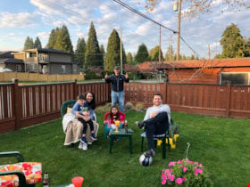
April visit with the Romero family
https://search.heritageburnaby.ca/link/museumdescription14747
- Repository
- Burnaby Village Museum
- Date
- 19 Apr. 2020
- Collection/Fonds
- Burnaby Village Museum COVID-19 collection
- Description Level
- Item
- Physical Description
- 1 photograph (jpg) : col. ; 72 dpi.
- Scope and Content
- Photograph of the Romero family visiting with Lorna and John Court in their yard outside of their house on Imperial Street in Burnaby. Gabriel and Gisela are seated with thier children Alicia and Pablo while John Court stands in the back corner of the yard. John is holding his hands out to show tha…
- Repository
- Burnaby Village Museum
- Collection/Fonds
- Burnaby Village Museum COVID-19 collection
- Description Level
- Item
- Physical Description
- 1 photograph (jpg) : col. ; 72 dpi.
- Scope and Content
- Photograph of the Romero family visiting with Lorna and John Court in their yard outside of their house on Imperial Street in Burnaby. Gabriel and Gisela are seated with thier children Alicia and Pablo while John Court stands in the back corner of the yard. John is holding his hands out to show that they are physcially distanced. During the visit they set up two family groups of chairs spaced far apart due to the COVID-19 pandemic and public health recommendations.
- History
- The photographer, Lorna Court took this picture during the COVID-19 pandemic.
- Subjects
- Pandemics - COVID-19
- Geographic Access
- Imperial Street
- Accession Code
- BV020.30.7
- Access Restriction
- No restrictions
- Reproduction Restriction
- No known restrictions
- Date
- 19 Apr. 2020
- Media Type
- Photograph
- Planning Study Area
- Morley-Buckingham Area
- Photographer
- Court, Lorna
- Notes
- Title based on contents of photograph
Images


Basketball Court Closed
https://search.heritageburnaby.ca/link/archivedescription95116
- Repository
- City of Burnaby Archives
- Date
- May 8, 2020
- Collection/Fonds
- Burnaby Photographic Society fonds
- Description Level
- Item
- Physical Description
- 1 photograph (tiff)
- Scope and Content
- Photograph of a closed basketball court at Edmonds Park. A City of Burnaby facility closure sign is attached to the fence outside the court and the basketball hoops are covered with thick orange netting.
- Repository
- City of Burnaby Archives
- Date
- May 8, 2020
- Collection/Fonds
- Burnaby Photographic Society fonds
- Physical Description
- 1 photograph (tiff)
- Description Level
- Item
- Record No.
- 623-034
- Access Restriction
- No restrictions
- Reproduction Restriction
- No restrictions
- Accession Number
- 2020-10
- Scope and Content
- Photograph of a closed basketball court at Edmonds Park. A City of Burnaby facility closure sign is attached to the fence outside the court and the basketball hoops are covered with thick orange netting.
- Media Type
- Photograph
- Photographer
- Peterman, Randall
- Notes
- Transcribed title
- Geographic Access
- Humphries Avenue
- Street Address
- 7433 Humphries Avenue
- Historic Neighbourhood
- Edmonds (Historic Neighbourhood)
- Planning Study Area
- Richmond Park Area
Images

Bateman family photographs series
https://search.heritageburnaby.ca/link/museumdescription15158
- Repository
- Burnaby Village Museum
- Date
- [1857]-[195-]
- Collection/Fonds
- E.W. Bateman family fonds
- Description Level
- Series
- Physical Description
- 63 photographs
- Scope and Content
- Series consists of family photographs of the Edwin Wettenhall Bateman family including the children and grandchildren of E.W. Bateman and Catherine "Cassie" (Dale) Bateman; parents of E.W. Bateman; parents of Catherine "Cassie" (Dale) and Mary (Dale) Bateman; Mary Bateman (second wife of E.W. Batem…
- Repository
- Burnaby Village Museum
- Collection/Fonds
- E.W. Bateman family fonds
- Description Level
- Series
- Physical Description
- 63 photographs
- Scope and Content
- Series consists of family photographs of the Edwin Wettenhall Bateman family including the children and grandchildren of E.W. Bateman and Catherine "Cassie" (Dale) Bateman; parents of E.W. Bateman; parents of Catherine "Cassie" (Dale) and Mary (Dale) Bateman; Mary Bateman (second wife of E.W. Bateman); Dora Coulton Bateman (third wife of E.W. Bateman) along with photographs of Elworth house in Burnaby and other family residences.
- Accession Code
- HV974.22
- HV974.90
- HV975.120
- HV976.37
- HV979.32
- BV985.1003
- BV986.21
- BV992.29
- BV994.22
- BV004.28
- BV004.84
- BV020.27
- Date
- [1857]-[195-]
- Media Type
- Photograph
- Notes
- Title based on contents of series
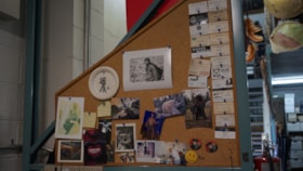
Bulletin board inside Jimmy Chow's office
https://search.heritageburnaby.ca/link/museumdescription19158
- Repository
- Burnaby Village Museum
- Date
- 2022
- Collection/Fonds
- Hipman "Jimmy" Chow and Donna Polos fonds
- Description Level
- Item
- Physical Description
- 1 photograph (jpg)
- Scope and Content
- Photograph of the interior of property master Jimmy Chow's warehouse studio space located on Grant Street in Burnaby. View of interior of workspace with cards and photographs pinned to a bulletin board. There is a large black and white photograph of Brad Pitt in costume on the set for the film "Sev…
- Repository
- Burnaby Village Museum
- Collection/Fonds
- Hipman "Jimmy" Chow and Donna Polos fonds
- Description Level
- Item
- Physical Description
- 1 photograph (jpg)
- Scope and Content
- Photograph of the interior of property master Jimmy Chow's warehouse studio space located on Grant Street in Burnaby. View of interior of workspace with cards and photographs pinned to a bulletin board. There is a large black and white photograph of Brad Pitt in costume on the set for the film "Seven Years in Tibet" pinned to the board.
- Subjects
- Industries - Film
- Accession Code
- BV022.21.5
- Access Restriction
- No restrictions
- Reproduction Restriction
- No known restrictions
- Date
- 2022
- Media Type
- Photograph
- Photographer
- Fong, Denise
- Notes
- Title based on contents of photograph
- Hipman "Jimmy" Chow also used the name "James H. Chow" as a propety master in the film industry and was often credited by this name
Images

Burnaby family fonds
https://search.heritageburnaby.ca/link/archivedescription58458
- Repository
- City of Burnaby Archives
- Date
- 1858-1863
- Collection/Fonds
- Robert Burnaby fonds
- Description Level
- Fonds
- Physical Description
- 5 cm. of textual records.
- Scope and Content
- Fonds consists of letters written by Robert Burnaby related to both his work and explorations in British Columbia as well as personal matters relating to his family. Some of these letters were published in the 2002 book, "Land of Promise: Robert Burnaby's Letters from Colonial British Columbia 1858…
- Repository
- City of Burnaby Archives
- Date
- 1858-1863
- Collection/Fonds
- Robert Burnaby fonds
- Physical Description
- 5 cm. of textual records.
- Description Level
- Fonds
- Access Restriction
- No restrictions
- Reproduction Restriction
- No known restrictions
- Accession Number
- 2009-06 2017-55
- Scope and Content
- Fonds consists of letters written by Robert Burnaby related to both his work and explorations in British Columbia as well as personal matters relating to his family. Some of these letters were published in the 2002 book, "Land of Promise: Robert Burnaby's Letters from Colonial British Columbia 1858-1863."
- History
- Robert Burnaby was a commission merchant and legislator, born on November 30, 1828, at Woodthorpe, Leicestershire, England, as the fourth son of the Reverend Thomas Burnaby and Sarah Meares. Robert Burnaby came to British Columbia at the end of 1858 as an experienced civil servant from Her Majesty’s Customs Office in London, and with a personal introduction to Governor James Douglas from Sir Edward Bulwer-Lytton. Burnaby’s first year on the Pacific coast was a busy one: he spent a short time as private secretary to Richard Clement Moody, commander of the Royal Engineers at New Westminster; he explored for coal with Walter Moberly at Burrard Inlet; and he made a short visit to San Francisco. During this year, he also founded the firm of Henderson and Burnaby, commission merchants, in partnership with Edward Henderson, an old school friend from Christ’s Hospital and a man of means, who managed the London office. This type of business was precarious since the distance from sources of supply and risks in transportation encouraged overtrading and excessive speculation. The death of Henderson in 1865 and the general economic depression in Vancouver Island and British Columbia brought the firm to an end – a failure caused in part apparently by unwise investment in real estate. Burnaby then embarked upon a real estate and insurance business of his own. The exigencies of a mercantile career seem to have overwhelmed this man who, by upbringing and training, was more suited to a position in government service. Robert Burnaby was intensely interested in the welfare of Vancouver Island and British Columbia, and did all in his power to promote stable economic conditions. Before the end of his second year in Victoria, he was elected to the Legislative Assembly of Vancouver Island for the districts of Esquimalt and Metchosin, and he served his constituents well for five years. He was one of the founders of the Victoria Chamber of Commerce. During an 1866 visit to London on private business, he attended a meeting of prominent Victoria merchants and officials who strongly favoured the union of the two colonies and other measures for developing and improving their economic prospects. This group carried its resolutions to the secretary of state for the colonies. Burnaby was an active freemason and helped found the First Victoria Lodge in 1860. Among his recreational pursuits was a love of drama, and in 1863, he served as president of Victoria’s Amateur Dramatic Association. Burnaby numbered among his intimate friends Colonel Moody, Arthur Thomas Bushby, Henry Pering Pellew Crease, Judge Matthew Baillie Begbie, Edward Graham Alston, and Thomas Elwyn. In 1869, severe ill health caused Burnaby’s retirement and, five years later, his return to England. Friends arranged for him to travel in the Hudson’s Bay Company bark Lady Lampson; they later presented her captain, James Gaudin, with a generous purse in gratitude for the attention he had paid the ailing Burnaby during the voyage. Early in 1878, news reached Victoria that this “prominent and much respected merchant” had died. An honest, conscientious man of spirit, a clear-headed thinker, a “power” in his masonic lodge, a lucid speaker, full of fun, and clever, Burnaby has been fittingly commemorated in a number of place names in British Columbia including a lake, a strait, an island, a municipality, two mountain ranges, and finally Burnaby Mountain, the seat of Simon Fraser University. Burnaby died a bachelor on January 10, 1878, at Woodthorpe. - This information has been adapted from the Dictionary of Canadian Biography.
- Media Type
- Textual Record
- Creator
- Burnaby, Robert
- Notes
- Title based on creator of fonds.

Burnaby hospital closes main entrance
https://search.heritageburnaby.ca/link/archivedescription95094
- Repository
- City of Burnaby Archives
- Date
- April 6, 2020
- Collection/Fonds
- Burnaby Photographic Society fonds
- Description Level
- Item
- Physical Description
- 1 photograph (tiff)
- Scope and Content
- Photograph of a rerouting sign posted to a sandwich board outside the Burnaby Hospital emergency lot. The sign states that the hospital entrance is closed and requests visitors use the Main Entrance of the hospital.
- Repository
- City of Burnaby Archives
- Date
- April 6, 2020
- Collection/Fonds
- Burnaby Photographic Society fonds
- Physical Description
- 1 photograph (tiff)
- Description Level
- Item
- Record No.
- 623-013
- Access Restriction
- No restrictions
- Reproduction Restriction
- No restrictions
- Accession Number
- 2020-10
- Scope and Content
- Photograph of a rerouting sign posted to a sandwich board outside the Burnaby Hospital emergency lot. The sign states that the hospital entrance is closed and requests visitors use the Main Entrance of the hospital.
- Subjects
- Buildings - Civic - Hospitals
- Geographic Features - Automobile Parking Lots
- Advertising Medium - Signs and Signboards
- Media Type
- Photograph
- Photographer
- Damer, Eric
- Notes
- Transcribed title
- Geographic Access
- Kincaid Street
- Street Address
- 3935 Kincaid Street
- Historic Neighbourhood
- Broadview (Historic Neighbourhood)
- Planning Study Area
- Cascade-Schou Area
Images

Burnaby Outdoor Club fonds
https://search.heritageburnaby.ca/link/archivedescription71572
- Repository
- City of Burnaby Archives
- Date
- 1991-2020
- Collection/Fonds
- Burnaby Outdoor Club fonds
- Description Level
- Fonds
- Physical Description
- 1 folder textual records + 3 optical discs : CD-ROM
- Scope and Content
- Fonds comprises the Burnaby Outdoor Club's monthly newsletter "Footnotes". The newsletter, started in June 1991, details the events and activities undertaken by the Club and includes information on membership and club development. The fonds includes June 1991 to January 2009 newsletters on paper an…
- Repository
- City of Burnaby Archives
- Date
- 1991-2020
- Collection/Fonds
- Burnaby Outdoor Club fonds
- Physical Description
- 1 folder textual records + 3 optical discs : CD-ROM
- Description Level
- Fonds
- Record No.
- MSS162
- Access Restriction
- No restrictions
- Accession Number
- 2012-12
- 2016-13
- 2018-24
- 2020-17
- Scope and Content
- Fonds comprises the Burnaby Outdoor Club's monthly newsletter "Footnotes". The newsletter, started in June 1991, details the events and activities undertaken by the Club and includes information on membership and club development. The fonds includes June 1991 to January 2009 newsletters on paper and January 2009 to December 2020 in digital form.
- History
- The Burnaby Outdoor Club was formed in 1991 for the purpose of promoting the care and enjoyment of the outdoor environment through hiking, cycling, and skiing, supplemented by a variety of other sports and activities. The Club holds numerous sport and social events throughout the year and the monthly newsletter provides an overview of these events.
- Media Type
- Textual Record
- Creator
- Burnaby Outdoor Club
Burnaby Photographic Society fonds
https://search.heritageburnaby.ca/link/archivedescription95081
- Repository
- City of Burnaby Archives
- Date
- 2020
- Collection/Fonds
- Burnaby Photographic Society fonds
- Description Level
- Fonds
- Physical Description
- 50 photographs (tiff)
- Scope and Content
- Fonds consists of photographs taken by Burnaby Photographic Society members to document the city of Burnaby during the coronavirus pandemic in 2020. The Society's theme for its 50th anniversary was COVID-19.
- Repository
- City of Burnaby Archives
- Date
- 2020
- Collection/Fonds
- Burnaby Photographic Society fonds
- Physical Description
- 50 photographs (tiff)
- Description Level
- Fonds
- Access Restriction
- No restrictions
- Accession Number
- 2020-10
- Scope and Content
- Fonds consists of photographs taken by Burnaby Photographic Society members to document the city of Burnaby during the coronavirus pandemic in 2020. The Society's theme for its 50th anniversary was COVID-19.
- History
- The Burnaby Photographic Society was established in 1970. The Society comprises photography hobbyists, enthusiasts, and professionals who meet weekly at the Shadbolt Centre for the Arts. Members participate in local and national competitions, conduct field outings, and host events including image critique evenings and an annual "Showcase" fundraiser and celebration of photography.
- Media Type
- Photograph
- Creator
- Burnaby Photographic Society
- Notes
- PC623

Burnaby's COVID-19 drive thru testing site
https://search.heritageburnaby.ca/link/museumdescription15374
- Repository
- Burnaby Village Museum
- Date
- 5 Apr. 2020
- Collection/Fonds
- Burnaby Village Museum COVID-19 collection
- Description Level
- Item
- Physical Description
- 1 photograph (jpg)
- Scope and Content
- Photograph of the COVID-19 drive thru testing site in Central Park parking lot in Burnaby. Orange traffic posts and wayfinding signs are set up in the parking lot.
- Repository
- Burnaby Village Museum
- Collection/Fonds
- Burnaby Village Museum COVID-19 collection
- Description Level
- Item
- Physical Description
- 1 photograph (jpg)
- Scope and Content
- Photograph of the COVID-19 drive thru testing site in Central Park parking lot in Burnaby. Orange traffic posts and wayfinding signs are set up in the parking lot.
- Subjects
- Advertising Medium - Signs and Signboards
- Geographic Features - Parks
- Public Services - Health Services
- Pandemics - COVID-19
- Geographic Access
- Central Park
- Imperial Street
- Accession Code
- BV021.2.39
- Access Restriction
- No restrictions
- Reproduction Restriction
- May be restricted by third party rights
- Date
- 5 Apr. 2020
- Media Type
- Photograph
- Historic Neighbourhood
- Central Park (Historic Neighbourhood)
- Planning Study Area
- Maywood Area
- Notes
- Title based on contents of photograph
Images


Burnaby's COVID-19 drive thru testing site
https://search.heritageburnaby.ca/link/museumdescription15375
- Repository
- Burnaby Village Museum
- Date
- 5 Apr. 2020
- Collection/Fonds
- Burnaby Village Museum COVID-19 collection
- Description Level
- Item
- Physical Description
- 1 photograph (jpg)
- Scope and Content
- Photograph of the COVID-19 drive thru testing site in Central Park parking lot in Burnaby. Orange traffic posts, wayfinding signs and white tents are set up in the parking lot.
- Repository
- Burnaby Village Museum
- Collection/Fonds
- Burnaby Village Museum COVID-19 collection
- Description Level
- Item
- Physical Description
- 1 photograph (jpg)
- Scope and Content
- Photograph of the COVID-19 drive thru testing site in Central Park parking lot in Burnaby. Orange traffic posts, wayfinding signs and white tents are set up in the parking lot.
- Subjects
- Advertising Medium - Signs and Signboards
- Geographic Features - Parks
- Public Services - Health Services
- Pandemics - COVID-19
- Geographic Access
- Central Park
- Imperial Street
- Accession Code
- BV021.2.40
- Access Restriction
- No restrictions
- Reproduction Restriction
- May be restricted by third party rights
- Date
- 5 Apr. 2020
- Media Type
- Photograph
- Historic Neighbourhood
- Central Park (Historic Neighbourhood)
- Planning Study Area
- Maywood Area
- Notes
- Title based on contents of photograph
Images


Burnaby's COVID-19 drive thru testing site
https://search.heritageburnaby.ca/link/museumdescription15376
- Repository
- Burnaby Village Museum
- Date
- 5 Apr. 2020
- Collection/Fonds
- Burnaby Village Museum COVID-19 collection
- Description Level
- Item
- Physical Description
- 1 photograph (jpg)
- Scope and Content
- Photograph of the COVID-19 drive thru testing site in Central Park parking lot in Burnaby. Orange traffic posts, wayfinding signs and white tents are set up in the parking lot.
- Repository
- Burnaby Village Museum
- Collection/Fonds
- Burnaby Village Museum COVID-19 collection
- Description Level
- Item
- Physical Description
- 1 photograph (jpg)
- Scope and Content
- Photograph of the COVID-19 drive thru testing site in Central Park parking lot in Burnaby. Orange traffic posts, wayfinding signs and white tents are set up in the parking lot.
- Subjects
- Advertising Medium - Signs and Signboards
- Geographic Features - Parks
- Public Services - Health Services
- Pandemics - COVID-19
- Geographic Access
- Central Park
- Imperial Street
- Accession Code
- BV021.2.41
- Access Restriction
- No restrictions
- Reproduction Restriction
- May be restricted by third party rights
- Date
- 5 Apr. 2020
- Media Type
- Photograph
- Historic Neighbourhood
- Central Park (Historic Neighbourhood)
- Planning Study Area
- Maywood Area
- Notes
- Title based on contents of photograph
Images


Burnaby's COVID-19 drive thru testing site
https://search.heritageburnaby.ca/link/museumdescription15377
- Repository
- Burnaby Village Museum
- Date
- 5 Apr. 2020
- Collection/Fonds
- Burnaby Village Museum COVID-19 collection
- Description Level
- Item
- Physical Description
- 1 photograph (jpg)
- Scope and Content
- Photograph of the COVID-19 drive thru testing site in Central Park parking lot in Burnaby. Orange traffic posts, wayfinding signs and white tents are set up in the parking lot.
- Repository
- Burnaby Village Museum
- Collection/Fonds
- Burnaby Village Museum COVID-19 collection
- Description Level
- Item
- Physical Description
- 1 photograph (jpg)
- Scope and Content
- Photograph of the COVID-19 drive thru testing site in Central Park parking lot in Burnaby. Orange traffic posts, wayfinding signs and white tents are set up in the parking lot.
- Subjects
- Advertising Medium - Signs and Signboards
- Geographic Features - Parks
- Public Services - Health Services
- Pandemics - COVID-19
- Geographic Access
- Central Park
- Imperial Street
- Accession Code
- BV021.2.42
- Access Restriction
- No restrictions
- Reproduction Restriction
- May be restricted by third party rights
- Date
- 5 Apr. 2020
- Media Type
- Photograph
- Historic Neighbourhood
- Central Park (Historic Neighbourhood)
- Planning Study Area
- Maywood Area
- Notes
- Title based on contents of photograph
Images


Burnaby's COVID-19 drive thru testing site
https://search.heritageburnaby.ca/link/museumdescription15378
- Repository
- Burnaby Village Museum
- Date
- 5 Apr. 2020
- Collection/Fonds
- Burnaby Village Museum COVID-19 collection
- Description Level
- Item
- Physical Description
- 1 photograph (jpg)
- Scope and Content
- Photograph of the COVID-19 drive thru testing site in Central Park parking lot in Burnaby. Orange traffic posts, wayfinding signs and white tents are set up in the parking lot.
- Repository
- Burnaby Village Museum
- Collection/Fonds
- Burnaby Village Museum COVID-19 collection
- Description Level
- Item
- Physical Description
- 1 photograph (jpg)
- Scope and Content
- Photograph of the COVID-19 drive thru testing site in Central Park parking lot in Burnaby. Orange traffic posts, wayfinding signs and white tents are set up in the parking lot.
- Subjects
- Advertising Medium - Signs and Signboards
- Geographic Features - Parks
- Public Services - Health Services
- Pandemics - COVID-19
- Geographic Access
- Central Park
- Imperial Street
- Accession Code
- BV021.2.43
- Access Restriction
- No restrictions
- Reproduction Restriction
- May be restricted by third party rights
- Date
- 5 Apr. 2020
- Media Type
- Photograph
- Historic Neighbourhood
- Central Park (Historic Neighbourhood)
- Planning Study Area
- Maywood Area
- Notes
- Title based on contents of photograph
Images


Burnaby's COVID-19 drive thru testing site
https://search.heritageburnaby.ca/link/museumdescription15379
- Repository
- Burnaby Village Museum
- Date
- 5 Apr. 2020
- Collection/Fonds
- Burnaby Village Museum COVID-19 collection
- Description Level
- Item
- Physical Description
- 1 photograph (jpg)
- Scope and Content
- Photograph of the COVID-19 drive thru testing site in Central Park parking lot in Burnaby. Orange traffic posts, wayfinding signs, white tents and white buildings converted from shipping containers are set up in the parking lot.
- Repository
- Burnaby Village Museum
- Collection/Fonds
- Burnaby Village Museum COVID-19 collection
- Description Level
- Item
- Physical Description
- 1 photograph (jpg)
- Scope and Content
- Photograph of the COVID-19 drive thru testing site in Central Park parking lot in Burnaby. Orange traffic posts, wayfinding signs, white tents and white buildings converted from shipping containers are set up in the parking lot.
- Subjects
- Advertising Medium - Signs and Signboards
- Geographic Features - Parks
- Public Services - Health Services
- Pandemics - COVID-19
- Geographic Access
- Central Park
- Imperial Street
- Accession Code
- BV021.2.44
- Access Restriction
- No restrictions
- Reproduction Restriction
- May be restricted by third party rights
- Date
- 5 Apr. 2020
- Media Type
- Photograph
- Historic Neighbourhood
- Central Park (Historic Neighbourhood)
- Planning Study Area
- Maywood Area
- Notes
- Title based on contents of photograph
Images


Burnaby's COVID-19 drive thru testing site
https://search.heritageburnaby.ca/link/museumdescription15380
- Repository
- Burnaby Village Museum
- Date
- 5 Apr. 2020
- Collection/Fonds
- Burnaby Village Museum COVID-19 collection
- Description Level
- Item
- Physical Description
- 1 photograph (jpg)
- Scope and Content
- Photograph of the COVID-19 drive thru testing site in Central Park parking lot in Burnaby. Orange traffic posts, wayfinding signs and white tents are set up in the parking lot.
- Repository
- Burnaby Village Museum
- Collection/Fonds
- Burnaby Village Museum COVID-19 collection
- Description Level
- Item
- Physical Description
- 1 photograph (jpg)
- Scope and Content
- Photograph of the COVID-19 drive thru testing site in Central Park parking lot in Burnaby. Orange traffic posts, wayfinding signs and white tents are set up in the parking lot.
- Subjects
- Advertising Medium - Signs and Signboards
- Geographic Features - Parks
- Public Services - Health Services
- Pandemics - COVID-19
- Geographic Access
- Central Park
- Imperial Street
- Accession Code
- BV021.2.45
- Access Restriction
- No restrictions
- Reproduction Restriction
- May be restricted by third party rights
- Date
- 5 Apr. 2020
- Media Type
- Photograph
- Historic Neighbourhood
- Central Park (Historic Neighbourhood)
- Planning Study Area
- Maywood Area
- Notes
- Title based on contents of photograph
Images


Burnaby's COVID-19 drive thru testing site
https://search.heritageburnaby.ca/link/museumdescription15381
- Repository
- Burnaby Village Museum
- Date
- 5 Apr. 2020
- Collection/Fonds
- Burnaby Village Museum COVID-19 collection
- Description Level
- Item
- Physical Description
- 1 photograph (jpg)
- Scope and Content
- Photograph of the COVID-19 drive thru testing site in Central Park parking lot in Burnaby. Orange traffic posts, wayfinding signs and white tents are set up in the parking lot.
- Repository
- Burnaby Village Museum
- Collection/Fonds
- Burnaby Village Museum COVID-19 collection
- Description Level
- Item
- Physical Description
- 1 photograph (jpg)
- Scope and Content
- Photograph of the COVID-19 drive thru testing site in Central Park parking lot in Burnaby. Orange traffic posts, wayfinding signs and white tents are set up in the parking lot.
- Subjects
- Advertising Medium - Signs and Signboards
- Geographic Features - Parks
- Public Services - Health Services
- Pandemics - COVID-19
- Geographic Access
- Central Park
- Imperial Street
- Accession Code
- BV021.2.46
- Access Restriction
- No restrictions
- Reproduction Restriction
- May be restricted by third party rights
- Date
- 5 Apr. 2020
- Media Type
- Photograph
- Historic Neighbourhood
- Central Park (Historic Neighbourhood)
- Planning Study Area
- Maywood Area
- Notes
- Title based on contents of photograph
Images


Burnaby's COVID-19 drive thru testing site
https://search.heritageburnaby.ca/link/museumdescription15382
- Repository
- Burnaby Village Museum
- Date
- 5 Apr. 2020
- Collection/Fonds
- Burnaby Village Museum COVID-19 collection
- Description Level
- Item
- Physical Description
- 1 photograph (jpg)
- Scope and Content
- Photograph of the COVID-19 drive thru testing site in Central Park parking lot in Burnaby. White shipping container buildings have been set up in the parking lot.
- Repository
- Burnaby Village Museum
- Collection/Fonds
- Burnaby Village Museum COVID-19 collection
- Description Level
- Item
- Physical Description
- 1 photograph (jpg)
- Scope and Content
- Photograph of the COVID-19 drive thru testing site in Central Park parking lot in Burnaby. White shipping container buildings have been set up in the parking lot.
- Subjects
- Advertising Medium - Signs and Signboards
- Geographic Features - Parks
- Public Services - Health Services
- Pandemics - COVID-19
- Geographic Access
- Central Park
- Imperial Street
- Accession Code
- BV021.2.47
- Access Restriction
- No restrictions
- Reproduction Restriction
- May be restricted by third party rights
- Date
- 5 Apr. 2020
- Media Type
- Photograph
- Historic Neighbourhood
- Central Park (Historic Neighbourhood)
- Planning Study Area
- Maywood Area
- Notes
- Title based on contents of photograph
Images


Burnaby's COVID-19 drive thru testing site
https://search.heritageburnaby.ca/link/museumdescription15383
- Repository
- Burnaby Village Museum
- Date
- 5 Apr. 2020
- Collection/Fonds
- Burnaby Village Museum COVID-19 collection
- Description Level
- Item
- Physical Description
- 1 photograph (jpg)
- Scope and Content
- Photograph of the COVID-19 drive thru testing site in Central Park parking lot in Burnaby. White shipping container buildings have been set up in the parking lot.
- Repository
- Burnaby Village Museum
- Collection/Fonds
- Burnaby Village Museum COVID-19 collection
- Description Level
- Item
- Physical Description
- 1 photograph (jpg)
- Scope and Content
- Photograph of the COVID-19 drive thru testing site in Central Park parking lot in Burnaby. White shipping container buildings have been set up in the parking lot.
- Subjects
- Advertising Medium - Signs and Signboards
- Geographic Features - Parks
- Public Services - Health Services
- Pandemics - COVID-19
- Geographic Access
- Central Park
- Imperial Street
- Accession Code
- BV021.2.48
- Access Restriction
- No restrictions
- Reproduction Restriction
- May be restricted by third party rights
- Date
- 5 Apr. 2020
- Media Type
- Photograph
- Historic Neighbourhood
- Central Park (Historic Neighbourhood)
- Planning Study Area
- Maywood Area
- Notes
- Title based on contents of photograph
Images

Burnaby Village Museum COVID-19 collection
https://search.heritageburnaby.ca/link/museumdescription14728
- Repository
- Burnaby Village Museum
- Date
- 2020
- Collection/Fonds
- Burnaby Village Museum COVID-19 collection
- Description Level
- Fonds
- Physical Description
- 49 photographs (jpgs) + 4 photographs (tiffs) + 1 drawing : wax crayon on pink construction paper + 26 videos (digital)
- Scope and Content
- Collection consists of photographs, digital poetry and a child's drawing created by citizens living in Burnaby during the COVID-19 pandemic as well as photographs and short film clips created by the City of Burnaby's Marketing Department. The collection documents experiences while living through th…
- Repository
- Burnaby Village Museum
- Collection/Fonds
- Burnaby Village Museum COVID-19 collection
- Description Level
- Fonds
- Physical Description
- 49 photographs (jpgs) + 4 photographs (tiffs) + 1 drawing : wax crayon on pink construction paper + 26 videos (digital)
- Scope and Content
- Collection consists of photographs, digital poetry and a child's drawing created by citizens living in Burnaby during the COVID-19 pandemic as well as photographs and short film clips created by the City of Burnaby's Marketing Department. The collection documents experiences while living through the COVID-19 pandemic, how it has effected the City of Burnaby and it's citizens and how they've adapted.
- History
- The COVID-19 pandemic, also known as the "Coronavirus" is a world wide pandemic caused by severe acute respiratory syndrome coronavirus 2 (SARS-CoV-2). The coronavirus was first identified in December 2019 in Wuhan, China and in January 2020, The World Health Organization declared the outbreak a Public Health Emergency of International Concern and by March 2020 it was declared a world wide pandemic. As of December 2020, more than 68 million cases have been confirmed and more than 1.56 million deaths have been attributed to COVID-19. In the spring of 2020, many provinces and territories within Canada declared a state of emergency or public health emergency. British Columbia declared a public health emergency on March 17 and a provincial state of emergency the next day, March 18. This state of emergency gives the provincial health authority the power to limit the sizes of gatherings and put restrictions on how businesses operate. The state of emergency order, which must be renewed every fourteen days, allows the province to implement any provincial emergency measures required such as securing the supply chain and prohibiting re-selling of essentials. During the pandemic British Columbia's provincial health officer Dr. Bonnie Henry provided wise words to the public and coined the phrase "This is our time to be kind, be calm and be safe". Beginning in May 2020, Burnaby Village Museum put a call out to the community asking for their assistance in documenting and collecting experiences, stories and mementos regarding the COVID-19 pandemic in Burnaby. Burnaby Village Museum put the word out through social media, their enewsletter, website, and word of mouth. The public was invited to share how COVID-19 was affecting them through physical objects, photographs, videos, recordings, letters, diaries and more. The City of Burnaby's Marketing Department also produced communications about the pandemic and changes throughout the City that residents need to be aware of. The goal of this collection is to document the effects that the pandemic has had on our community and our everyday lives and in turn preserve and make it accessible for future generations. Burnaby Village Museum continues to collect any items documenting everyday experiences related to this pandemic.
- Creator
- Burnaby Village Museum
- Subjects
- Pandemics - COVID-19
- Accession Code
- BV020.18; BV020.19; BV020.20; BV020.21; BV020.23; BV020.24; BV020.26; BV020.30; BV021.2
- Date
- 2020
- Media Type
- Photograph
- Textual Record
- Moving Images
- Notes
- Title based on contents of collection
- Multiple accessions form part of this fonds: BV020.18; BV020.19; BV020.20; BV020.21; BV020.23; BV020.24; BV020.26; BV020.30; BV021.2
- Further accruals are expected

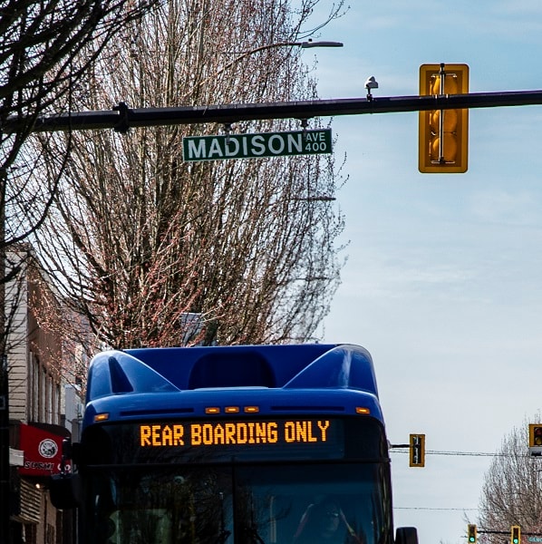
Bus Practices
https://search.heritageburnaby.ca/link/archivedescription95126
- Repository
- City of Burnaby Archives
- Date
- April 10, 2020
- Collection/Fonds
- Burnaby Photographic Society fonds
- Description Level
- Item
- Physical Description
- 1 photograph (tiff)
- Scope and Content
- Photograph of the destination sign on a bus at East Hastings Street and Madison Avenue that reads "Rear Boarding Only".
- Repository
- City of Burnaby Archives
- Date
- April 10, 2020
- Collection/Fonds
- Burnaby Photographic Society fonds
- Physical Description
- 1 photograph (tiff)
- Description Level
- Item
- Record No.
- 623-044
- Access Restriction
- No restrictions
- Reproduction Restriction
- Reproduce for fair dealing purposes only
- Accession Number
- 2020-10
- Scope and Content
- Photograph of the destination sign on a bus at East Hastings Street and Madison Avenue that reads "Rear Boarding Only".
- Subjects
- Transportation - Buses
- Media Type
- Photograph
- Photographer
- Jerome, Ron
- Notes
- Transcribed title
- Geographic Access
- Hastings Street
- Madison Avenue
- Historic Neighbourhood
- Vancouver Heights (Historic Neighbourhood)
- Planning Study Area
- Burnaby Heights Area
Images
Bylaw Number: 575 - Land Sale Bylaw No 1, 1927
https://search.heritageburnaby.ca/link/bylaw22873
- Repository
- Legislative Services
- Bylaw Number
- 575
- Final Adoption
- 2027 Mar 28
- Format
- Bylaws - Adopted
- Collection/Fonds
- City Council and Office of the City Clerk fonds
- Repository
- Legislative Services
- Bylaw Number
- 575
- Final Adoption
- 2027 Mar 28
- Format
- Bylaws - Adopted
- Collection/Fonds
- City Council and Office of the City Clerk fonds
Documents
Bylaw Number: 13585 - Zoning Bylaw 1965, Amendment Bylaw No. 9, 2016
https://search.heritageburnaby.ca/link/bylaw24756
- Repository
- Legislative Services
- Bylaw Number
- 13585
- Final Adoption
- 2020 Oct 26
- Format
- Bylaws - Adopted
- Collection/Fonds
- City Council and Office of the City Clerk fonds
- Repository
- Legislative Services
- Bylaw Number
- 13585
- Final Adoption
- 2020 Oct 26
- Format
- Bylaws - Adopted
- Collection/Fonds
- City Council and Office of the City Clerk fonds
Documents
Bylaw Number: 13643 - Zoning Bylaw 1965, Amendment Bylaw No. 38, 2016
https://search.heritageburnaby.ca/link/bylaw24862
- Repository
- Legislative Services
- Bylaw Number
- 13643
- Final Adoption
- 2021 Jul 26
- Format
- Bylaws - Adopted
- Collection/Fonds
- City Council and Office of the City Clerk fonds
- Repository
- Legislative Services
- Bylaw Number
- 13643
- Final Adoption
- 2021 Jul 26
- Format
- Bylaws - Adopted
- Collection/Fonds
- City Council and Office of the City Clerk fonds
Documents
Bylaw Number: 13729 - Zoning Bylaw 1965, Amendment Bylaw No. 10, 2017
https://search.heritageburnaby.ca/link/bylaw24955
- Repository
- Legislative Services
- Bylaw Number
- 13729
- Final Adoption
- 2021 Nov 22
- Format
- Bylaws - Adopted
- Collection/Fonds
- City Council and Office of the City Clerk fonds
- Repository
- Legislative Services
- Bylaw Number
- 13729
- Final Adoption
- 2021 Nov 22
- Format
- Bylaws - Adopted
- Collection/Fonds
- City Council and Office of the City Clerk fonds
Documents
Bylaw Number: 13764 - Zoning Bylaw 1965, Amendment Bylaw No. 22, 2017
https://search.heritageburnaby.ca/link/bylaw24993
- Repository
- Legislative Services
- Bylaw Number
- 13764
- Final Adoption
- 2021 Mar 29
- Format
- Bylaws - Adopted
- Collection/Fonds
- City Council and Office of the City Clerk fonds
- Repository
- Legislative Services
- Bylaw Number
- 13764
- Final Adoption
- 2021 Mar 29
- Format
- Bylaws - Adopted
- Collection/Fonds
- City Council and Office of the City Clerk fonds
Documents
Bylaw Number: 13775 - Zoning Bylaw 1965, Amendment Bylaw No. 27, 2017
https://search.heritageburnaby.ca/link/bylaw25003
- Repository
- Legislative Services
- Bylaw Number
- 13775
- Final Adoption
- 2021 Jul 26
- Format
- Bylaws - Adopted
- Collection/Fonds
- City Council and Office of the City Clerk fonds
- Repository
- Legislative Services
- Bylaw Number
- 13775
- Final Adoption
- 2021 Jul 26
- Format
- Bylaws - Adopted
- Collection/Fonds
- City Council and Office of the City Clerk fonds
Documents
Bylaw Number: 13854 - Zoning Bylaw 1965, Amendment Bylaw No. 5, 2018
https://search.heritageburnaby.ca/link/bylaw25087
- Repository
- Legislative Services
- Bylaw Number
- 13854
- Final Adoption
- 2021 Jul 12
- Format
- Bylaws - Adopted
- Collection/Fonds
- City Council and Office of the City Clerk fonds
- Repository
- Legislative Services
- Bylaw Number
- 13854
- Final Adoption
- 2021 Jul 12
- Format
- Bylaws - Adopted
- Collection/Fonds
- City Council and Office of the City Clerk fonds
Documents
Bylaw Number: 13874 - Zoning Bylaw 1965, Amendment Bylaw No. 12, 2018
https://search.heritageburnaby.ca/link/bylaw25110
- Repository
- Legislative Services
- Bylaw Number
- 13874
- Final Adoption
- 2020 Nov 09
- Format
- Bylaws - Adopted
- Collection/Fonds
- City Council and Office of the City Clerk fonds
- Repository
- Legislative Services
- Bylaw Number
- 13874
- Final Adoption
- 2020 Nov 09
- Format
- Bylaws - Adopted
- Collection/Fonds
- City Council and Office of the City Clerk fonds
Documents
Bylaw Number: 13899 - Zoning Bylaw 1965, Amendment Bylaw No. 20, 2018
https://search.heritageburnaby.ca/link/bylaw25133
- Repository
- Legislative Services
- Bylaw Number
- 13899
- Final Adoption
- 2020 Dec 14
- Format
- Bylaws - Adopted
- Collection/Fonds
- City Council and Office of the City Clerk fonds
- Repository
- Legislative Services
- Bylaw Number
- 13899
- Final Adoption
- 2020 Dec 14
- Format
- Bylaws - Adopted
- Collection/Fonds
- City Council and Office of the City Clerk fonds
Documents
Bylaw Number: 13915 - Zoning Bylaw 1965, Amendment Bylaw No. 27, 2018.
https://search.heritageburnaby.ca/link/bylaw25159
- Repository
- Legislative Services
- Bylaw Number
- 13915
- Final Adoption
- 2021 Nov 08
- Format
- Bylaws - Adopted
- Collection/Fonds
- City Council and Office of the City Clerk fonds
- Repository
- Legislative Services
- Bylaw Number
- 13915
- Final Adoption
- 2021 Nov 08
- Format
- Bylaws - Adopted
- Collection/Fonds
- City Council and Office of the City Clerk fonds
Documents
Bylaw Number: 13924 - Zoning Bylaw 1965, Amendment Bylaw No. 32, 2018
https://search.heritageburnaby.ca/link/bylaw25185
- Repository
- Legislative Services
- Bylaw Number
- 13924
- Final Adoption
- 2020 Aug 24
- Format
- Bylaws - Adopted
- Collection/Fonds
- City Council and Office of the City Clerk fonds
- Repository
- Legislative Services
- Bylaw Number
- 13924
- Final Adoption
- 2020 Aug 24
- Format
- Bylaws - Adopted
- Collection/Fonds
- City Council and Office of the City Clerk fonds
Documents
Bylaw Number: 13927 - Zoning Bylaw 1965, Amendment Bylaw No. 35, 2018
https://search.heritageburnaby.ca/link/bylaw25162
- Repository
- Legislative Services
- Bylaw Number
- 13927
- Final Adoption
- 2020 Nov 23
- Format
- Bylaws - Adopted
- Collection/Fonds
- City Council and Office of the City Clerk fonds
- Repository
- Legislative Services
- Bylaw Number
- 13927
- Final Adoption
- 2020 Nov 23
- Format
- Bylaws - Adopted
- Collection/Fonds
- City Council and Office of the City Clerk fonds
Documents
Bylaw Number: 13945 - Zoning Bylaw 1965, Amendment Bylaw No. 42, 2018
https://search.heritageburnaby.ca/link/bylaw25180
- Repository
- Legislative Services
- Bylaw Number
- 13945
- Final Adoption
- 2021 Apr 26
- Format
- Bylaws - Adopted
- Collection/Fonds
- City Council and Office of the City Clerk fonds
- Repository
- Legislative Services
- Bylaw Number
- 13945
- Final Adoption
- 2021 Apr 26
- Format
- Bylaws - Adopted
- Collection/Fonds
- City Council and Office of the City Clerk fonds
Documents
Bylaw Number: 13972 - Zoning Bylaw 1965, Admendment Bylaw No. 48, 2018
https://search.heritageburnaby.ca/link/bylaw25209
- Repository
- Legislative Services
- Bylaw Number
- 13972
- Final Adoption
- 2021 Jul 26
- Format
- Bylaws - Adopted
- Collection/Fonds
- City Council and Office of the City Clerk fonds
- Repository
- Legislative Services
- Bylaw Number
- 13972
- Final Adoption
- 2021 Jul 26
- Format
- Bylaws - Adopted
- Collection/Fonds
- City Council and Office of the City Clerk fonds
Documents
Bylaw Number: 13973 - Zoning Bylaw 1965, Amendment Bylaw No. 49, 2018
https://search.heritageburnaby.ca/link/bylaw25210
- Repository
- Legislative Services
- Bylaw Number
- 13973
- Final Adoption
- 2020 Oct 26
- Format
- Bylaws - Adopted
- Collection/Fonds
- City Council and Office of the City Clerk fonds
- Repository
- Legislative Services
- Bylaw Number
- 13973
- Final Adoption
- 2020 Oct 26
- Format
- Bylaws - Adopted
- Collection/Fonds
- City Council and Office of the City Clerk fonds
Documents
Bylaw Number: 13974 - Zoning Bylaw 1965, Amendment Bylaw No. 50, 2018
https://search.heritageburnaby.ca/link/bylaw25211
- Repository
- Legislative Services
- Bylaw Number
- 13974
- Final Adoption
- 2021 Apr 26
- Format
- Bylaws - Adopted
- Collection/Fonds
- City Council and Office of the City Clerk fonds
- Repository
- Legislative Services
- Bylaw Number
- 13974
- Final Adoption
- 2021 Apr 26
- Format
- Bylaws - Adopted
- Collection/Fonds
- City Council and Office of the City Clerk fonds
Documents
Bylaw Number: 13992 - Zoning Bylaw 1965, Amendment Bylaw No. 5, 2019
https://search.heritageburnaby.ca/link/bylaw25234
- Repository
- Legislative Services
- Bylaw Number
- 13992
- Final Adoption
- 2021 Mar 29
- Format
- Bylaws - Adopted
- Collection/Fonds
- City Council and Office of the City Clerk fonds
- Repository
- Legislative Services
- Bylaw Number
- 13992
- Final Adoption
- 2021 Mar 29
- Format
- Bylaws - Adopted
- Collection/Fonds
- City Council and Office of the City Clerk fonds
Documents
Bylaw Number: 13994 - Zoning Bylaw 1965, Amendment Bylaw No. 7, 2019
https://search.heritageburnaby.ca/link/bylaw25236
- Repository
- Legislative Services
- Bylaw Number
- 13994
- Final Adoption
- 2021 Aug 30
- Format
- Bylaws - Adopted
- Collection/Fonds
- City Council and Office of the City Clerk fonds
- Repository
- Legislative Services
- Bylaw Number
- 13994
- Final Adoption
- 2021 Aug 30
- Format
- Bylaws - Adopted
- Collection/Fonds
- City Council and Office of the City Clerk fonds