More like 'Interview with Josephine Chow by Denise Fong February 7, 2020'
Narrow Results By
Decade
- 2020s 148
- 2010s 111
- 2000s 1066
- 1990s 635
- 1980s 568
- 1970s 1373
- 1960s 427
- 1950s 621
- 1940s 595
- 1930s 523
- 1920s 542
- 1910s
- 1900s 262
- 1890s 46
- 1880s 52
- 1870s 6
- 1860s 3
- 1850s 1
- 1840s 1
- 1830s 2
- 1820s 1
- 1810s 1
- 1800s 1
- 1790s 1
- 1780s 1
- 1770s 1
- 1760s 1
- 1750s 1
- 1740s 1
- 1730s 1
- 1720s 1
- 1710s 1
- 1700s 1
- 1690s 1
- 1680s 1
- 1670s 1
- 1660s 1
- 1650s 1
- 1640s 1
- 1630s 1
- 1620s 1
- 1610s 1
- 1600s 1
Creator
- Barrowclough, G.A. 1
- Barrowclough, George Alfred 1
- BC Photo Card Company 1
- Brown, W. 1
- Burnaby Village Museum 4
- Burnett and McGugan B.C. Land Surveyors, New Westminster 5
- Burnett, Geoffrey K. 3
- Burnett & McGugan, Engineers and Surveyors 22
- Canadian Photo Company 12
- Challoner-Courtenay, E.J. 2
- Damer, Eric 1
- Davis-Watkins Dairymen's Manufacturing Company 1

Edmonds Baptist Church
https://search.heritageburnaby.ca/link/landmark575
- Repository
- Burnaby Heritage Planning
- Description
- Church building.
- Associated Dates
- 1912
- Street View URL
- Google Maps Street View
- Repository
- Burnaby Heritage Planning
- Geographic Access
- Walker Avenue
- Associated Dates
- 1912
- Description
- Church building.
- Heritage Value
- Beautifully designed in an Arts and Crafts idiom, this church features a textural mix of finishes including lapped siding and stucco and half timbering in the gables. The British Columbian reported in July 1912 that: "The Baptists of Edmonds will possess a fine and well planned church when the building now commenced is ready for occupation. The architects are J.P. Matheson and Son, of Vancouver, and the contractors, Muttitt and Bell, of New Westminster. The entrance porch fronts Edmonds Road and the west side faces Vancouver Road. It will have a capacity for 272 sittings, spacious aisles and choir platform besides various rooms for Baptistery, vestry and robing apartments."
- Locality
- Edmonds
- Historic Neighbourhood
- Edmonds (Historic Neighbourhood)
- Planning Study Area
- Richmond Park Area
- Architect
- J.P. Matheson & Son
- Builder
- Muttitt and Bell
- Area
- 1471.58
- Contributing Resource
- Building
- Ownership
- Private
- Names
- Matheson, John
- Street Address
- 7135 Walker Avenue
- Street View URL
- Google Maps Street View
Images


H.T. Ceperley Estate 'Fairacres' Mansion
https://search.heritageburnaby.ca/link/landmark526
- Repository
- Burnaby Heritage Planning
- Description
- 'Fairacres' is a large, two-and-one-half storey estate house in the British Arts and Crafts style, located in Deer Lake Park, with four associated original outbuildings.
- Associated Dates
- 1911
- Formal Recognition
- Heritage Designation, Community Heritage Register
- Other Names
- Henry Tracy & Grace Ceperley Estate
- Burnaby Art Gallery
- Street View URL
- Google Maps Street View
- Repository
- Burnaby Heritage Planning
- Other Names
- Henry Tracy & Grace Ceperley Estate
- Burnaby Art Gallery
- Geographic Access
- Deer Lake Avenue
- Associated Dates
- 1911
- Formal Recognition
- Heritage Designation, Community Heritage Register
- Enactment Type
- Bylaw No. 9807
- Enactment Date
- 23/11/1992
- Description
- 'Fairacres' is a large, two-and-one-half storey estate house in the British Arts and Crafts style, located in Deer Lake Park, with four associated original outbuildings.
- Heritage Value
- 'Fairacres' is important as a record of the early years of Burnaby, specifically the Deer Lake area, as a place of tranquility and beautiful scenery in which the wealthy and successful in the burgeoning cities of New Westminster and Vancouver chose to retire or to make their family homes. The main house, which anchors in style and setting the outbuildings on the estate, demonstrates the social, cultural, and aesthetic values of local wealthy businessmen and women of the early twentieth century - values such as appreciation of architectural elegance and grand interior spaces, leisure and recreation, formal landscaped gardens and scenic views. Also important is the association with the English-born and trained architect Robert Mackay Fripp (1858-1917), as this was one of his grandest residential commissions. Steeped in the current architectural trends in Great Britain, Fripp designed this sprawling mansion in the Arts and Crafts style, reflected in the architectural detailing and proportions. The style was common at the time and was often used for estate mansions as a symbol of affluence and good, modern taste as well as an affinity for all things British. Quality is displayed inside and out in the finishes and materials, orchestrated by prominent local contractor, James Charles Allen, including imported English materials of specific value such as imported Medmenham tiles in the fireplace surrounds, one of the earliest documented use of these tiles outside the United Kingdom. Detailed features of the interior woodwork were carved by Scottish-born master wood carver George Selkirk Gibson (1867-1942), who was best known for his many commissions for prominent British Columbia architect Samuel Maclure. The outbuildings at 'Fairacres' are an important record of the functioning of a large estate of the time. The Garage and Stables and the Chauffeur’s Cottage accommodated the use of automobiles, horses and carriages, and in concert with the estate's location near the new British Columbia Electric Railway 'Burnaby Lake' interurban line, illustrate the evolving nature of regional transportation and the growing bedroom communities and estates made possible by increasing options for transportation. Other outbuildings accommodated the agricultural activities that helped support the Ceperley estate. The estate was conceived and funded by American-born Grace E. Dixon Ceperley (1863-1917), who had achieved significant wealth through a bequest from her brother-in-law, Vancouver pioneer Arthur Ferguson. Her husband, Henry Tracy Ceperley (1850-1929), also American-born, was a successful and well-respected businessman who made a significant contribution to the development of the City of Vancouver. The construction of 'Fairacres' spawned the transformation of the Deer Lake area from a farming community into a preferred location for elite suburban homes. 'Fairacres' is significant to the City of Burnaby as its first civic heritage conservation project. Acquired in 1966 for conversion to Burnaby’s first art gallery, it was dedicated in 1967 to mark Canada’s Centennial of Confederation.
- Defining Elements
- Key elements that define the heritage character of the ‘Fairacres’ mansion include its: - setting in relation to the gardens, its former market garden, and the vistas to Deer Lake and other grand homes in the area - side gable roof with prominent dormers and cedar shingle cladding - verandah across the eastern (garden) facade, with its view over the landscaped gardens and the distant mountains - porte cochere with its side steps for those arriving by automobile, and central raised step for those alighting from horse-drawn carriages - rich variety of exterior elements that demonstrate the typical Arts and Crafts use of local materials such as cobble stone chimneys and foundations, wide wooden siding and half-timbering - mixture of double-hung and casement wooden-sash windows, many with multi-paned sash - lavish interior spaces, designed for entertaining on a grand scale, including a billiard room with a beamed ceiling and an inglenook fireplace, and generous living and dining rooms arranged off a central hall - quality of the interior materials such as imported Medmenham tiles in fireplace surrounds, window hardware by Hope and Sons, and leaded stained glass - interior wood work including the staircase, and carvings by George Selkirk Gibson - remaining formal Edwardian garden landscape elements, including the cross-axial plan that reflects the relationship of the mansion to its 'outdoor rooms'
- Locality
- Deer Lake Park
- Historic Neighbourhood
- Burnaby Lake (Historic Neighbourhood)
- Planning Study Area
- Douglas-Gilpin Area
- Architect
- Robert Mackay Fripp
- Function
- Primary Current--Museum
- Primary Historic--Estate
- Community
- Burnaby
- Cadastral Identifier
- P.I.D. No. 004-493-311 Legal Description: Block 3 Except: Part subdivided by Plan 26865, District Lot 79, Group 1, New Westminster District, Plan 536
- Boundaries
- ‘Fairacres’ is comprised of a single municipally-owned property located at 6344 Deer Lake Avenue, Burnaby.
- Area
- 17,065.00
- Contributing Resource
- Building
- Landscape Feature
- Ownership
- Public (local)
- Other Collection
- City of Burnaby, Visual Art Collection: Original rendering by R.P.S. Twizell Burnaby Historical Society, Community Archives: Ceperley Photograph Album Burnaby Village Museum, Collection: Carved dining room panels by G.S. Gibson and other hardware items
- Documentation
- Heritage Site Files: PC77000 20. City of Burnaby Planning and Building Department, 4949 Canada Way, Burnaby, B.C., V5G 1M2
- Names
- Ceperley, Grace
- Ceperley, H.T.
- Fripp, Robert Mackay
- Allen, James Charles
- Gibson, George Selkirk
- Street Address
- 6344 Deer Lake Avenue
- Street View URL
- Google Maps Street View
Images


H.T. Ceperley Estate 'Fairacres' Chauffeur's Cottage
https://search.heritageburnaby.ca/link/landmark529
- Repository
- Burnaby Heritage Planning
- Description
- Designed in the British Arts and Crafts style, the Chauffeur's Cottage is situated across from the main entrance to the Ceperley Mansion, and adjacent to the Garage and Stables. A long, narrow single-storey building, it was constructed by joining together two modest estate cottages.
- Associated Dates
- 1911
- Formal Recognition
- Heritage Designation, Community Heritage Register
- Repository
- Burnaby Heritage Planning
- Geographic Access
- Deer Lake Avenue
- Associated Dates
- 1911
- Formal Recognition
- Heritage Designation, Community Heritage Register
- Enactment Type
- Bylaw No. 9807
- Enactment Date
- 23/11/1992
- Description
- Designed in the British Arts and Crafts style, the Chauffeur's Cottage is situated across from the main entrance to the Ceperley Mansion, and adjacent to the Garage and Stables. A long, narrow single-storey building, it was constructed by joining together two modest estate cottages.
- Heritage Value
- The outbuildings at 'Fairacres' are a rare surviving architecturally designed ensemble of agricultural structures that exist in complementary harmony with the main estate house. Architect Robert Mackay Fripp (1858-1917) was retained by the Ceperleys to design several original outbuildings on their estate at the same time as the main house was constructed. The Chauffeur's Cottage illustrates the increasing importance of the automobile in the lives of the wealthy of the early twentieth century. It also demonstrates Grace and Henry Tracy Ceperley's social aspirations and grand-country-estate pretension in having a chauffeur. The cottage's location - close to the garage and convenient, but not adjacent, to the main house - enhances the grand country house landscape design and contributes to the overall composition of the estate's plan. The Arts and Crafts styled Chauffeur's Cottage is important as an indicator of the aesthetic and social sensibilities of the Ceperley family in retaining an architect to design a modest building for staff accommodation.
- Defining Elements
- Key elements that define the heritage character of the 'Fairacres' Chauffeur's Cottage include its: - location, in relation to the main house and in close proximity to the Garage and Stables buildings - side gable roof with cedar shingle cladding - Arts and Crafts architectural features such as the jerkin-headed door hood, a reference to the thatched-roofed cottages of southern England; eight-paned wooden-sash casement windows; and cedar-shingled exterior - two internal brick chimneys - modest, functional interior, with simple trim and lack of pretension
- Locality
- Deer Lake Park
- Historic Neighbourhood
- Burnaby Lake (Historic Neighbourhood)
- Planning Study Area
- Douglas-Gilpin Area
- Architect
- Robert Mackay Fripp
- Function
- Primary Historic--Outbuilding
- Community
- Burnaby
- Cadastral Identifier
- P.I.D. No. 004-493-311 Legal Description: Block 3 Except: Part subdivided by Plan 26865, District Lot 79, Group 1, New Westminster District, Plan 536
- Boundaries
- ‘Fairacres’ is comprised of a single municipally-owned property located at 6344 Deer Lake Avenue, Burnaby.
- Area
- 17,065.00
- Contributing Resource
- Building
- Landscape Feature
- Ownership
- Public (local)
- Other Collection
- Burnaby Historical Society, Community Archives: Ceperley Photograph Album Burnaby Village Museum, Collection: Chinese ‘Tiger Whiskey’ and opium bottles found during restoration
- Documentation
- Heritage Site Files: PC77000 20. City of Burnaby Planning and Building Department, 4949 Canada Way, Burnaby, B.C., V5G 1M2
- Street Address
- 6344 Deer Lake Avenue
Images


H.T. Ceperley Estate 'Fairacres' Garage & Stables
https://search.heritageburnaby.ca/link/landmark530
- Repository
- Burnaby Heritage Planning
- Description
- Designed in the British Arts and Crafts style, the ‘Fairacres’ Garage and Stables is a two-storey wood frame building located on the 'Fairacres' estate, situated to the north of the Chauffeur's Cottage; at the south end of the structure is a single vehicle garage and to the north are several stable…
- Associated Dates
- 1911
- Formal Recognition
- Heritage Designation, Community Heritage Register
- Street View URL
- Google Maps Street View
- Repository
- Burnaby Heritage Planning
- Geographic Access
- Deer Lake Avenue
- Associated Dates
- 1911
- Formal Recognition
- Heritage Designation, Community Heritage Register
- Enactment Type
- Bylaw No. 9807
- Enactment Date
- 23/11/1992
- Description
- Designed in the British Arts and Crafts style, the ‘Fairacres’ Garage and Stables is a two-storey wood frame building located on the 'Fairacres' estate, situated to the north of the Chauffeur's Cottage; at the south end of the structure is a single vehicle garage and to the north are several stables for carriage, riding, and draught horses, a coach house, and tack room; the upper floor was originally a hay loft.
- Heritage Value
- The outbuildings at 'Fairacres' are a rare surviving architecturally designed ensemble of agricultural structures that exist in complementary harmony with the main estate house. Architect Robert Mackay Fripp (1858-1917) was retained by the Ceperleys to design several original outbuildings on their estate at the same time as the main house was constructed. The Garage and Stables building is important as a record of its era when transportation modes were in transition and the horse-drawn carriage, while still in use, was giving way to the automobile. The relative spatial arrangements within the building are a valuable indication of the economy of space associated with the automobile, as compared to the horse. The extent of the stabling arrangements signifies not only the use of carriage horses but also the continued reliance on draught horses in farming activities in this era. As well, it is an indication of the fashionable nature of equestrianism for wealthy families during this time. The building is important as a demonstration of the aesthetics of the Ceperley family in having an architect-designed outbuilding and obtaining craftsmanship and materials of the highest quality for each structure on their estate.
- Defining Elements
- Key elements that define the heritage character of the 'Fairacres' Garage and Stables include its: - location within easy reach of the main house and in close proximity to the Chauffeur's Cottage - floor plan with the garage at one end, close to the Chauffeur's Cottage, and stables and equine facilities at the other - variety and complexity of the roofline, including gable wall dormers, gable-on-hip roof ends, and half-hip extensions - Arts and Crafts architectural features of the exterior such as the shingle wall cladding articulated with a chevron-patterned course of shingles at the first floor level; casement windows; and deep eaves with additional purlins to support the overhang - original stable doors with hand-made forged-iron door hardware - multi-paned wooden-sash windows, some retaining original wire glass
- Locality
- Deer Lake Park
- Historic Neighbourhood
- Burnaby Lake (Historic Neighbourhood)
- Planning Study Area
- Douglas-Gilpin Area
- Architect
- Robert Mackay Fripp
- Function
- Primary Historic--Outbuilding
- Community
- Burnaby
- Cadastral Identifier
- P.I.D. No. 004-493-311 Legal Description: Block 3 Except: Part subdivided by Plan 26865, District Lot 79, Group 1, New Westminster District, Plan 536
- Boundaries
- ‘Fairacres’ is comprised of a single municipally-owned property located at 6344 Deer Lake Avenue, Burnaby.
- Area
- 17,065.00
- Contributing Resource
- Building
- Landscape Feature
- Ownership
- Public (local)
- Other Collection
- Burnaby Historical Society, Community Archives: Ceperley Photograph Album
- Documentation
- Heritage Site Files: PC77000 20. City of Burnaby Planning and Building Department, 4949 Canada Way, Burnaby, B.C., V5G 1M2
- Street Address
- 6344 Deer Lake Avenue
- Street View URL
- Google Maps Street View
Images


![Survey and Subdivision plans in New Westminster District Group 1 and Group 2 – Vancouver, ʷməθkʷəy̓əm (Musqueam) Indian Reserve, Burnaby, Surrey
, [1910-1911] thumbnail](/media/hpo/_Data/_BVM_Cartographic_Material/1977/1977_0093_0017_001.jpg?width=280)
Survey and Subdivision plans in New Westminster District Group 1 and Group 2 – Vancouver, ʷməθkʷəy̓əm (Musqueam) Indian Reserve, Burnaby, Surrey
https://search.heritageburnaby.ca/link/museumdescription6986
- Repository
- Burnaby Village Museum
- Date
- [1910-1911]
- Collection/Fonds
- Burnaby Village Museum Map collection
- Description Level
- File
- Physical Description
- 9 plans : 4 plans : blueprint ink on paper + 4 plans : black ink on paper + 1 plan : graphite on paper mounted on 2 sides of cardboard 76 x 102 cm
- Scope and Content
- File consists of a large board of three survey plans in New Westminster District Group 1 mounted on one side and six survey and subdivision plans of District Lot 85, New Westminster District Group 1 mounted on the other side. Side A: 1. Plan : blueprint on paper ; 30.5 x 80 cm. Title reads: "Fras…
- Repository
- Burnaby Village Museum
- Collection/Fonds
- Burnaby Village Museum Map collection
- Description Level
- File
- Physical Description
- 9 plans : 4 plans : blueprint ink on paper + 4 plans : black ink on paper + 1 plan : graphite on paper mounted on 2 sides of cardboard 76 x 102 cm
- Material Details
- Scales vary (One chain equals 792 inches)
- Indexed number on tape on edge of board reads "17"
- Scope and Content
- File consists of a large board of three survey plans in New Westminster District Group 1 mounted on one side and six survey and subdivision plans of District Lot 85, New Westminster District Group 1 mounted on the other side. Side A: 1. Plan : blueprint on paper ; 30.5 x 80 cm. Title reads: "Fraser River Bridge / Plan of South Approach". Plan covers area of land north of the Fraser River and Great Northern Railway with approach for a bridge running through the "ʷməθkʷəy̓əm (Musqueam) Indian Reserve" (ʷməθkʷəy̓əm (Musqueam) First Nation) and lots marked as Dominion Government and the east half of Lot 2 identified as "C. F. Brown" "Plan 851". Plan is identified as "Plan 851 / traced / Mar. 17, 1911". (Geographic location in Vancouver) Scale: 100 feet = 1 inch, Signed by Albert J. Hill / P.L.S." 2. Plan : blueprint on paper ; 36.5 x 35 cm (no title). Includes three plans of lots on the east and west sides of North Road. Note on bottom of blueprint reads: "I.E.B. McKay Surveyor General - hereby certify / that this is a correct tracing from the field / notes of the Royal Engineers on file in the / Lands Department / E.B. McKay (signature) / Surveyor General / Victoria B.C. April 11th 1911" . Plan in top left titled "Page 11 / Vol. 1. / R.E. Notes" covers District Lots east of North Road including Lot 5, Lot 7, Lot 41, Lot 9 and Lot 107 in Coquitlam. Plan in top right corner titled "Page 17 / Vol. 1. / R.E. Notes" covers District Lots east of North Road including Lot 104, Lot 54, Lot 105, Lot 55, Lot 106, Lot 9 and Lot 107 in Coquitlam and Port Moody. Plan in lower left corner titled "Page 15 / Vol. 1 / R.E. Notes" covers District Lots west of North Road including Lot 147, Lot 148, Lot 100, Lot 15 in Burnaby. 3. Plan : blue print on paper ; 29.5 x 41.5 cm. (no formal title). Plan of the North 1/2 of Section 18. Plan covers area in the "North 1/2 of Sec.18 B.5 N RGE 1 W" and "Sec. 18 B.5 N. RGE 1 W" bordered by Section 7, Section 13, Section 17 and Section 19. Bon Accord Road runs through Sec. 18. The plan is signed by surveryor "I.H. Neville Smith... C.E.B.C.L.S. / Mar. 26th 1910" and signed by "Ludwig Pillath". (Geographic location: Surrey) Side B: 1. Plan : blueprint on paper ; 43.5 x 49.5 cm. Title reads: "Plan / of Subdivision / of a Portion / of / Lot 85 / Group One / New Westminster District. Plan covers portion of land east of Deer Lake and Pole Line Road (Sperling Avenue) and south of Hastings Road in District Lot 85 in Burnaby with section 4 and a portion of section 2 coloured in red. Plan is signed by "Albert J. Hill, B.C.L.S." Plan is initialed by: "RB" [sic] (in blue pencil crayon) Scale: 4 chains = 1 inch 2. Plaln : black black ink on linen ; 39 x 37 cm. Title reads: "L.C. Hill's Property, / Burnaby". Plan covers a triangular portion of land east of Pole Line Road (Sperling Avenue) and south of Hastings Road in District Lot 85 in Burnaby. Plan is intitaled by "RB" [sic] (in blue pencil crayon). Scale: 3 chains = 1 mile 3. Plan : graphite on paper ; 23 x 17 cm. Title reads: "Portion of Lot 85 / Gr.1". Plan covers portion of land north east of Deer Lake and west of Pole Line Road (now Sperling Avenue) in District Lot 85 in Burnaby. Plan is stamped in red ink: "Albert J. Hill, Civil Engineer". Plan is initialed by: "RB" [sic] (in blue pencil crayon). Scale: 1 chain = 1 inch 4. Plan : black ink on linen ; 16 x 19 cm. Title reads: "Lot 85". Plan covers the intersection of Pole Line Road (Sperling Avenue) and Hastings Road at the north west section of District Lot 79 and District Lot 85 in Burnaby. Plan is stamped: "A.J. Hill, Civil Engineer" with identitifed in blue pencil crayon. 5. Plan : black ink on paper ; 28.5 x 37 cm. (no formal title) Plan covers an area of land, west of Pole Line Road (Sperling Avenue) and south of Deer Lake in District Lot 85 in Burnaby. Plan is initialed by: "RB" [sic] (in blue pencil crayon) 6. Plan : black ink on paper ; 21 x 34 cm (no formal title). Plan covers an area of land, west of Pole Line Road (Sperling Avenue) and south of Deer Lake in District Lot 85 in Burnaby. Plan is initialed by: "RB" [sic] (in blue pencil crayon)
- Accession Code
- HV977.93.17
- Access Restriction
- No restrictions
- Reproduction Restriction
- No known restrictions
- Date
- [1910-1911]
- Media Type
- Cartographic Material
- Historic Neighbourhood
- Burnaby Lake (Historic Neighbourhood)
- Burquitlam (Historic Neighbourhood)
- Planning Study Area
- Morley-Buckingham Area
- Douglas-Gilpin Area
- Scan Resolution
- 600
- Scan Date
- 2023-06-26
- Notes
- Title based on contents of file
- Scale is measured in chains and feet. (One chain equals 792 inches).
- The term "Lot" also refers to a "District Lot”
- Some plans are stamped: "Albert J. Hill, Civil Engineer / and / Provincial Land Surveyor, / New Westminster, / B.C." and intialed: "RB" [sic]
Zoomable Images
![Survey and Subdivision plans in New Westminster District Group 1 and Group 2 – Vancouver, ʷməθkʷəy̓əm (Musqueam) Indian Reserve, Burnaby, Surrey
, [1910-1911] thumbnail](/media/hpo/_Data/_BVM_Cartographic_Material/1977/1977_0093_0017_003_seadragon/1977_0093_0017_003.jpg?w=280)
Survey and Subdivision plans in New Westminster District Group 1 and Group 2 – Vancouver, ʷməθkʷəy̓əm (Musqueam) Indian Reserve, Burnaby, Surrey , [1910-1911]
Zoom into Image
![Survey and Subdivision plans in New Westminster District Group 1 & Group 2 - Port Moody, Surrey
, [1898-1910] thumbnail](/media/hpo/_Data/_BVM_Cartographic_Material/1977/1977_0093_0073_001.jpg?width=280)
Survey and Subdivision plans in New Westminster District Group 1 & Group 2 - Port Moody, Surrey
https://search.heritageburnaby.ca/link/museumdescription7042
- Repository
- Burnaby Village Museum
- Date
- [1898-1910]
- Collection/Fonds
- Burnaby Village Museum Map collection
- Description Level
- File
- Physical Description
- 10 plans : graphite and ink on paper and linen; various sizes mounted on 2 sides of cardboard 76 x 102 cm
- Scope and Content
- File consists of a large board with four plans in New Westminster District mounted on one side and six plans mounted on the other side. Side A: 1. Plan : black ink and graphite on paper ; 46.5 x 37.5 cm. Title reads: "Bon Accord Hatchery / Sec 6 B5N R1W". Signed by Albert J. Hill P.L.S. August 1…
- Repository
- Burnaby Village Museum
- Collection/Fonds
- Burnaby Village Museum Map collection
- Description Level
- File
- Physical Description
- 10 plans : graphite and ink on paper and linen; various sizes mounted on 2 sides of cardboard 76 x 102 cm
- Material Details
- Scales vary (One chain equals 792 inches)
- Indexed number on tape on edge of board reads "73"
- Scope and Content
- File consists of a large board with four plans in New Westminster District mounted on one side and six plans mounted on the other side. Side A: 1. Plan : black ink and graphite on paper ; 46.5 x 37.5 cm. Title reads: "Bon Accord Hatchery / Sec 6 B5N R1W". Signed by Albert J. Hill P.L.S. August 12, 1903. Plan covers land identified as Section 6, Section 7, Located along the south shore of the Fraser River in Port Mann (Geographic location: Surrey). 2. Plan : black ink and graphite on paper ; 36 x 31 cm. Title reads: "Survey of Portions of Sec. 20 B5N R2W". Plan is stamped in red ink: "Albert J. Hill, Civil Engineer". Scale 4 chains = 1 inch. 3. Plan : black ink on linen ; 14 x 23 cm. Title reads:"Port Moody". Plan covers sections in Lot 191 (District Lot 191) bordered by Burrard Inlet to the west and Lot 235 and Lot 233 to the south. Streets identified include Water Street, Beauregard Street, Yonge Street, Clinton Street and Oxford Street. 4. Plan: graphite and ink on paper ; 43.5 x 64.5 cm. Title reads: "Sketch Plan Approved by Council [sic] / _[sic]1898". (No identifying geographic landmarks provided) Side B: 1. Plan : graphite on paper ; 53.5 x 31 cm. Title reads: "Plan of Lot 13, Gr. II, N.W. Dist". Sketch plan covers area along the Fraser River in District Lot 13, New Westminster District, Group 2. District Lot 13 is bordered by District Lot 14 (to the west) and Lot 12 (to the east). Natural geographic features within District Lot 13 are noted as "dense brush and fallen timber / sallal / rough spruce and cedar / swamp / fine alder / sallal / fine alder bottom land / fine brook". Scale: 3 chains = 1 inch (Geographic location: Surrey) 2. Plan : black ink on paper ; 50.5 x 34.5 cm. Title reads: "Indian Reserve / Opposite / New Westminster". Plan covers area on the south shore of the Fraser River in New Westminster District Group 2 in an area known as Brownsville. Lots are identified as District Lots 1, 2, 3, 4, 18, 17 and 8 and Sections A and B. Two areas of land are noted as "Indian Reserve"; one 6.3 acre parcel and one 104.25 acre parcel, both within District Lot 1. Note on plan reads: "N.B. this plan shows reserves and adjacent properties as they are on the ground". (Geographic location: Surrey) 3. Plan : black and col. ink on paper ; 19.5 x 31.5 cm. Title reads: "Bon Accord Road". Plan shows elevation. "Average section 10 feet = 1 inch". Plan is stamped in red ink: "Albert J. Hill, Civil Engineer and Provincial Land Surveyor, New Westminster, B.C." (Geographic location: Surrey) 4. Plan : black and col. ink on linen ; 16.5 x 25.5 cm. (no formal title) Plan covers area of Section 35, south of Yale Wagon Road and east of Quible Road. Plan is signed by "Albert J. Hill / B.C.L.S." (Geographic location: Surrey) 5. Plan: black and col. ink on linen ; 22.5 x 22.5 cm. (no formal title) Plan covers area between Yale Road and Townline Road in Surrey. Scale: 4 chains = 1 inch. Plan is signed by Albert J. Hill B.C.L.S. [190-] (Geographic location: Surrey) 6. Plan : graphite on paper ; 24 x 54 cm. (no formal title) Plan covers sectioned areas along Bon Accord Road. Sections are identified as " Sec. 8 / T.F. Patterson"; "Sec. 9 / Russell"; "Elliott_Burnett_Crean / Sec. 16"; "Dom. Govt. / Sec. 17". (Geographic location: Surrey, beneath the Port Mann bridge)
- Names
- ʷməθkʷəy̓əm (Musqueam)
- Accession Code
- HV977.93.73
- Access Restriction
- No restrictions
- Reproduction Restriction
- No known restrictions
- Date
- [1898-1910]
- Media Type
- Cartographic Material
- Scan Resolution
- 600
- Scan Date
- 2023-06-26
- Notes
- Title based on contents of file
- Note re plan 2B: The sight of Brownsville was also the former site of the Qayqayt First Nation and one of the main summer villages of the Kwantlen and ʷməθkʷəy̓əm (Musqueam) peoples
Zoomable Images
![Survey and Subdivision plans in New Westminster District Group 1 & Group 2 - Port Moody, Surrey
, [1898-1910] thumbnail](/media/hpo/_Data/_BVM_Cartographic_Material/1977/1977_0093_0073_003_seadragon/1977_0093_0073_003.jpg?w=280)
Survey and Subdivision plans in New Westminster District Group 1 & Group 2 - Port Moody, Surrey , [1898-1910]
Zoom into Image
![Survey and Subdivision plans in New Westminster District Group 2 - Surrey, Delta
, [1898-1910] thumbnail](/media/hpo/_Data/_BVM_Cartographic_Material/1977/1977_0093_0078_001.jpg?width=280)
Survey and Subdivision plans in New Westminster District Group 2 - Surrey, Delta
https://search.heritageburnaby.ca/link/museumdescription7047
- Repository
- Burnaby Village Museum
- Date
- [1898-1910]
- Collection/Fonds
- Burnaby Village Museum Map collection
- Description Level
- File
- Physical Description
- 10 plans : graphite and ink on paper and linen; various sizes mounted on 2 sides of cardboard 76 x 102 cm
- Scope and Content
- File consists of a large board with four plans in New Westminster District mounted on one side and six plans mounted on the other side. Side A: 1. Plan : black ink on paper with colour (no formal title). Plan covers area in New Westminster District, Group 2 situated along the south shore of the …
- Repository
- Burnaby Village Museum
- Collection/Fonds
- Burnaby Village Museum Map collection
- Description Level
- File
- Physical Description
- 10 plans : graphite and ink on paper and linen; various sizes mounted on 2 sides of cardboard 76 x 102 cm
- Material Details
- Scales vary
- Indexed number on tape on edge of board reads "78"
- Scope and Content
- File consists of a large board with four plans in New Westminster District mounted on one side and six plans mounted on the other side. Side A: 1. Plan : black ink on paper with colour (no formal title). Plan covers area in New Westminster District, Group 2 situated along the south shore of the Fraser River identified as "Indian Reserve / Turner 1868" situated in District Lot 1 between District Lot 2 identified as "Mohun's Line" and "Herring's Line" bordered by lots B and A. Includes note "see plan of subdivision of Lots 3 & 4 Gr. 2". (Geographic location: Surrey) 2. Plan : graphite on paper ; Title reads: "B5N R2W, Sec.26_Sec. 28 / Sec. 35_Sec.36". Plan covers a 60 acre parcel in Sec. 35 with Yale wagon road to the south. Scale: 6 chains = 1 inch (Geographic location: Surrey) 3. Plan : black ink on paper ; Title reads: "Survey for Proposed Highway in Indian Reserve Surrey". Plan covers area of land to the northwest of Lot 2 along the shore of the Fraser River and identfies route of proposed highway, proposed tramway as well at the Great Northern Railway and bridge. Scale: 2 chains = 1 inch 4. Plan : black ink on red lined graphing paper ; Title reads: "Sketch Plan Showing Section of Great Northern R. of W. at Point of Crossing of Proposed Ditch". Plan covers area of Lot 2 in New Westminster District, Group 2. (Surrey) Scale: 1 inch = 5 feet. (Geographic location: Surrey) Side B: 1. Plan : black ink on paper ; Title reads: "Plan of Subdivision of a Portion of Section 13, TP2, Surrey Municipality, New Westminster District, B.C.". Plan covers land bordered by Coast Meridian Road (to the east), Bose Road (to the south) and Pike Road (to the west). Surveyed for D.S. Bayners, Nov. 24, 1908. Scale: 5 chains= 1 inch 2. Plan : black ink on linen with colour ; Title reads: "Traverse of the Waterline in front of Lots 3 and 4, Group 2, New Westminster District with G.N. Railway Right of Way". Plan covers area along the southern shore of the Fraser River with a road crossing the Great Northern Railway and leading to a wharf. Scale: 100 feet = 1 inch (Geographic location: Surrey) 3. Plan : black ink on paper ; Title reads: "Survey of the South Boundary of Sec. 12, Township 2, New Westminster District". Plan covers area south of Bose Road and west of Coast Meridean Road and north of McClellen Road. Scale: 400 feet = 1 inch. Sec.12 (Geographic location: Surrey) 4. Plan : graphite on paper ; Title reads: "Plan of Subdivisioin of a part of S.E. 1/4 of Sec. 7, TP 8". Plan covers area of Section 7 in New Westminster District, Group 2, Township 8. Streets are identified running through lot including, Langley Ave., Robinson Ave, Melrose Ave., Hawthorne Ave., Broadway, Bond Ave., Mable Ave., Breene Ave. and McLelland Ave. and Clover Valley Road. Scale: 200 feet = 1 inch. Note in black ink reads: See Bd. 166 for blue print. (Geographic location: Surrey) 5. Plan : graphite on linen ; Title reads: "Sec.20, B5N R2W". Plan covers area north of Yale Road and is subdivided into parts identified as A, B, C, D, E, and unknown. (Geographic location: Surrey) 6. Plan : black ink and graphite on paper ; (no formal title) Plan covers lots surveyed along Ladner Road identified as A, B and Lots 13, 12 and 11. [Geographic location: Delta]
- Accession Code
- HV977.93.78
- Access Restriction
- No restrictions
- Reproduction Restriction
- No known restrictions
- Date
- [1898-1910]
- Media Type
- Cartographic Material
- Scan Resolution
- 600
- Scan Date
- 2023-06-26
- Notes
- Title based on contents of file
- Note re plans 1A & 3A: The sight of Brownsville was also the former site of the Qayqayt First Nation and one of the main summer villages of the Kwantlen and ʷməθkʷəy̓əm (Musqueam) peoples
- Scale is measured in chains and feet. (One chain equals 792 inches)
Zoomable Images
![Survey and Subdivision plans in New Westminster District Group 2 - Surrey, Delta
, [1898-1910] thumbnail](/media/hpo/_Data/_BVM_Cartographic_Material/1977/1977_0093_0078_003_seadragon/1977_0093_0078_003.jpg?w=280)
Survey and Subdivision plans in New Westminster District Group 2 - Surrey, Delta , [1898-1910]
Zoom into Image
![Chinese man working in field, [191-] thumbnail](/media/hpo/_Data/_BVM_Images/2022/2022_0032_0175_001.jpg?width=280)
Chinese man working in field
https://search.heritageburnaby.ca/link/museumdescription19753
- Repository
- Burnaby Village Museum
- Date
- [191-]
- Collection/Fonds
- Esther Love Stanley fonds
- Description Level
- Item
- Physical Description
- 1 photograph : b&w ; 5.5 x 8 cm
- Scope and Content
- Photograph of an unidentified Chinese man crouched down and working in a field. A gardening hoe is leaning on his shoulder and there are young trees growing behind him. This field and orchard could be located on the Love family property.
- Repository
- Burnaby Village Museum
- Collection/Fonds
- Esther Love Stanley fonds
- Description Level
- Item
- Physical Description
- 1 photograph : b&w ; 5.5 x 8 cm
- Scope and Content
- Photograph of an unidentified Chinese man crouched down and working in a field. A gardening hoe is leaning on his shoulder and there are young trees growing behind him. This field and orchard could be located on the Love family property.
- Accession Code
- BV022.32.175
- Access Restriction
- No restrictions
- Reproduction Restriction
- No known restrictions
- Date
- [191-]
- Media Type
- Photograph
- Scan Resolution
- 600
- Scan Date
- 2023-04-04
- Notes
- Title based on contents of photograph
- Photograph is part of Esther Love Stanley photograph album 1 (BV022.32.1)
Images
![Chinese man working in field, [191-] thumbnail](/media/hpo/_Data/_BVM_Images/2022/2022_0032_0175_001.jpg)
Interview with Norman Dowad
https://search.heritageburnaby.ca/link/museumdescription19638
- Repository
- Burnaby Village Museum
- Date
- [1890-2023] (interview content), interviewed 14 Aug. 2023
- Collection/Fonds
- Burnaby Village Museum fonds
- Description Level
- Item
- Physical Description
- 1 sound recording (wav) (61 min., 37 sec.) + 1 sound recording (mp3) (61 min., 37 sec.)
- Scope and Content
- Item consists of a recording of an oral history interview with Norman Dowad conducted by Burnaby Village Museum Registrar, Eric Damer on August 14, 2023. 00:00:00 – 00:14:38 Norm shares biographical information about himself and background information on the Dowad family. Norm conveys information …
- Repository
- Burnaby Village Museum
- Collection/Fonds
- Burnaby Village Museum fonds
- Series
- Museum Oral Histories series
- Subseries
- Many Voices Project Interviews subseries
- Description Level
- Item
- Physical Description
- 1 sound recording (wav) (61 min., 37 sec.) + 1 sound recording (mp3) (61 min., 37 sec.)
- Material Details
- Interviewer: Eric Damer Interviewee: Norman Dowad Location of Interview: Burnaby Village Museum Interview Date: August 14, 2023 Total Number of tracks: 1 Total Length of all Tracks: 01:14:37 Digital master recording (wav) was converted to mp3 for access on Heritage Burnaby
- Scope and Content
- Item consists of a recording of an oral history interview with Norman Dowad conducted by Burnaby Village Museum Registrar, Eric Damer on August 14, 2023. 00:00:00 – 00:14:38 Norm shares biographical information about himself and background information on the Dowad family. Norm conveys information about his grandfather Samuel Dowad's immigration to Canada and his father Wilfred Dowad's military service and successes as a property developer. 00:14:39 – 00:17:26 Norm provides background information on his mother’s side of the family. 00:17:27 – 00:31:36 Norm talks about his childhood, growing up in the Deer Lake neighbourhood, his early education in Burnaby and sports that he played. 00:31:37 – 00:39:59 Norm talks about his educational experiences attending Simon Fraser University, University of British Columbia and Osgoode Hall law school and information regarding his law career. 00:40:00 – 00:45:03 Norm reflects on his childhood growing up in Burnaby and on his experiences and relationships as a student and in his career as a lawyer. 00:45:04 – 01:01:37 Norm talks about his siblings and shares information about family property development projects as well as career and business successes. In closing he talks about research that he’s done through Archives Canada on his grandfather Sam Dowad and father Wilfred Dowad.
- History
- Interviewee biography: Norm Dowad was born in Burnaby, December 1948 to parents Wilfred “Wilf” (1925-2011) and Cherry Dowad. His father, Wilfred (1925-2011) was born in Winnipeg to parents Samuel “Sam” (Salim in Arabic) Esper Dowad (1895-1969) and Martha (Shaheen) Dowad (1894-1955). Sam and Martha Dowad were both born in a province of the Ottoman Empire which is now present day Lebanon. In 1912, while trying to immigrate to Canada, several of Sam’s relatives including his mother died tragically as steerage passengers on the ill fated Titanic. In 1913, at the age of 18 years, Sam immigrated to Canada to join other family members who'd already arrived here safely. As a new immigrant in Canada, Sam worked with other Labanese immigrants in Saskatchewan, Manitoba and the United States. In December 1921, Sam's wife, Martha immigrated to Canada arriving by ship in St. John, New Brunswick. Sam and Martha established their home in Winnipeg where they began to start a family. Their first two children died in infancy and son Wilfred was born in 1925 and daughter Kathleen was born in 1926. While living in Winnipeg, Sam worked as a grocer and in the 1930’s he got work as a farmer in a nearby town. In 1943, Wilf joined the Royal Canadian Naval Volunteer Reserve (RCVNR) and served as a gunner on merchant ships during World War II. In 1945, while Wilf was away serving, his parents, Sam and Martha moved to Burnaby. After discharge in 1945, Wilf joined his parents in Burnaby, began working at Fraser Mills and commenced his studies in construction and drafting. In 1949, with his father’s help Wilf acquired a lot next door to his parents’ home and built his first apartment block. After Martha died in 1954, Sam moved to Kelowna where he bought an orchard. Sam remarried in 1957 to Naomi “Mamie” (David) Dowad (1899-1978) who was also from a Lebanese family. Sam and Mamie lived in Kelowna until the mid 1960s when they moved to White Rock. While living in Burnaby, Wilf met and married Cherry Piggott and the couple had six children; Norm, Bruce, Michael, Kathie, Phil and Tom. In 1955, Wilfred Dowad established "W. Dowad Ltd." and over the years he was successful in developing and subdividing land to build housing and commercial developments in Burnaby, New Westminster and Vancouver. Wilf was the first president of the Burnaby Winter club and was an active member of the Junior Chamber of Commerce holding office at the local, provincial and national level. In 1970, Wilf purchased 238 acres of land bordering the Sḵwx̱wú7mesh River and relocated there the following year. While living in Sḵwx̱wú7mesh, Wilf became actively engaged in local business and community affairs. Wilf was later remarried to Grethe Dowad and he died in Sḵwx̱wú7mesh in 2011.Wilf's six children are the sole owners of "W.Dowad Ltd." and his daughter, Kathie Smillie is the president and CEO. While growing up in Burnaby, Norm Dowad attended Schou Street School, Douglas Road School, Kensington School and graduated from Burnaby Central Secondary School. Following graduation from high school, Norm attended Simon Fraser University for one year, travelled in Europe, attended University of British Columbia and obtained his law degree from Osgoode Hall at York University. Norman has been practicing law for 49 years and has his own law practice that he operates out of Vancouver. Interviewer biography: Eric Damer is a Burnaby Village Museum Interpreter, Museum Registrar, Researcher and Blacksmith. Eric pounded hot steel for the first time in 1977 in junior high. Fifteen years later, he joined Burnaby Village Museum where he has smithed for three decades. He also provides historical research for museum exhibits and special projects. Outside the museum, Eric is a social historian with a special interest in educational history.
- Creator
- Burnaby Village Museum
- Subjects
- Agriculture - Farms
- Education
- Persons - South Asian Canadians
- Migration
- Sports
- Sports - Football
- Wars - World War, 1939-1945
- Names
- Dowad, Norman W. "Norm"
- Dowad, Samuel Esper "Sam"
- Dowad, Wilfred "Wilf"
- Dowad, Naomi "Mamie" David
- Dowad, Martha Elias Shaheen
- Dowad, Kathleen "Kay"
- Rideout, Dr. John Anthony
- Burnaby Central Secondary School
- Douglas Road School
- W. Dowad Limited
- Responsibility
- Damer, Eric
- Geographic Access
- Buckingham Avenue
- Deer Lake
- Street Address
- 5533 Buckingham Avenue
- Accession Code
- BV023.16.16
- Access Restriction
- No restrictions
- Reproduction Restriction
- No known restrictions
- Date
- [1890-2023] (interview content), interviewed 14 Aug. 2023
- Media Type
- Sound Recording
- Historic Neighbourhood
- Burnaby Lake (Historic Neighbourhood)
- Planning Study Area
- Morley-Buckingham Area
- Notes
- Title based on contents of item
- Transcription available
Documents
Audio Tracks
Interview with Norman Dowad, [1890-2023] (interview content), interviewed 14 Aug. 2023
Interview with Norman Dowad, [1890-2023] (interview content), interviewed 14 Aug. 2023
https://search.heritageburnaby.ca/media/hpo/_Data/_BVM_Sound_Recordings/Oral_Histories/2023_0016_0016_002.mp3Interview with Harry Toy, Beverley Babey and Christina Toy
https://search.heritageburnaby.ca/link/museumdescription20285
- Repository
- Burnaby Village Museum
- Date
- [1905-2023] (interview content), interviewed 25 Sep. 2023
- Collection/Fonds
- Burnaby Village Museum fonds
- Description Level
- Item
- Physical Description
- 1 sound recordings (wav) (121min., 14 sec.) + 1 sound recording (mp3) (121 min., 13 sec.)
- Scope and Content
- Item consists of a recording of an oral history interview with Harry Toy, Beverley Babey and Christina Toy conducted by Burnaby Village Museum researcher Denise Fong on September 25, 2023. The interview is divided into four sections: early life of Harry Toy, the Canada Way Food Market, the Fraser M…
- Repository
- Burnaby Village Museum
- Collection/Fonds
- Burnaby Village Museum fonds
- Series
- Museum Oral Histories series
- Subseries
- Many Voices Project Interviews subseries
- Description Level
- Item
- Physical Description
- 1 sound recordings (wav) (121min., 14 sec.) + 1 sound recording (mp3) (121 min., 13 sec.)
- Material Details
- Interviewer: Denise Fong Interviewees: Harry Toy, Beverley Babey and Christina Toy Location of Interview: Residence of Harry Toy Interview Date: September 25, 2023 Total Number of tracks: 1 Total Length of all Tracks: 02:01:13 Digital master recording (wav) was converted to mp3 for access on Heritage Burnaby
- Scope and Content
- Item consists of a recording of an oral history interview with Harry Toy, Beverley Babey and Christina Toy conducted by Burnaby Village Museum researcher Denise Fong on September 25, 2023. The interview is divided into four sections: early life of Harry Toy, the Canada Way Food Market, the Fraser Merchants’ Association and Harry's daughters, Beverley Babey and Christina Toy's memories of growing up in Burnaby. 00:00:00 – 00:23:53 Harry Toy shares biographical information about himself and his ancestors. Harry provides information about his migration to Canada and his life in Manitoba, attending school, working at the family restaurant and teaching high school. 00:23:53 – 00:41:16 Harry talks about moving his family to Burnaby and his experiences owning and operating the Canada Way Food Market. 00:41:17 – 00:54:19 Harry talks about his involvement with the Fraser Merchants Association (FMA) and provides some history about the organization. 00:54:20 – 1:22:44 Harry talks about running the Canada Way Food Market and the alterations that he made to the store over the years. Harry and his daughters comment as they look through photographs of Harry and his store and the Fraser Merchants Association. 1:22:45 – 2:01:14 Beverley and Christina talk about their early childhood in Manitoba and growing up in Burnaby. They recall what it was like growing up and working in the family owned store.
- History
- Interviewee biography: Harry Wee Koon Toy was born in February 9, 1936 in Taikong, Toisan county, Guangdong, China. Harry's father William Toy came to Canada in the early 1920s when he was ten years old. Harry arrived in Vancouver, Canada on September 9, 1950. After staying in Vancouver for one night, he joined his father in Neepawa, Manitoba where the family operated a cafe business (Royal Cafe). Harry grew up in Neepawa and graduated from the University of Manitoba and teacher's college. He became a high school teacher and worked at schools in Minnedosa and Gladstone, Manitoba teaching various subjects including, science, business, geography, history and physical education. Harry and his wife, had three daughters, Melinda, Beverley and Christina who were all born in Neepawa. When the family decided to move to the west coast, Harry was introduced to the grocery store business through an uncle who was a store operator. Around 1970, Harry purchased a grocery store at 4694 Canada Way in Burnaby which he named "Canada Way Food Market" and Harry and his daughters made their home at the back of the store. Harry owned and operated the store for approximately 40 years between 1970 and 2010. Around 1986, Harry purchased the butcher shop next door (4692 Canada Way) which was no longer in operation, expanding his store and adding a second storey to use a residence. Harry's children helped him operate the store throughout their childhood. In the early 1970s, corner stores were threatened by the spread of small chain-operated convenience stories from Eastern Canada to Vancouver. Formed in April 1972, the Fraser Merchants’ Association was established to protect the rights of corner store operators. With no paid legal help, the association was incorporated in Victoria, BC for the cost of 56 cents. The benefits of being a member of the association included warehouse and group purchasing, common advertising and other advantages of being part of an association. Founded by Gary Lee Ling and five others, Fraser Merchants’ Association’s first member was Graham Grocery. By 1978, the association represented over 200 corner stores in the Lower Mainland (Delta, Surrey, White Rock, Langley, Coquitlam, and New Westminster) and Fraser Valley. The association remained active into the 1980s and 1990s. Harry has served as President of the Fraser Merchants' Association from 1992 to present. Interviewer biography: Denise Fong is a historical researcher at Burnaby Village Museum. She has degrees in Anthropology (BA) and Archaeology (MA), and is completing her doctoral degree at UBC in Interdisciplinary Studies. Her primary research interests are in Chinese Canadian history and critical heritage studies. She is the co-curator of BVM’s “Across the Pacific” exhibition, and the Museum of Vancouver’s “A Seat at the Table – Chinese Immigration and British Columbia”.
- Creator
- Burnaby Village Museum
- Subjects
- Education
- Migration
- Occupations - Teachers
- Occupations - Grocers
- Organizations
- Organizations - Business Associations
- Persons - Chinese Canadians
- Social Issues
- Social Issues - Racism
- Buildings - Commercial - Grocery Stores
- Names
- Toy, Christina
- Toy, Harry Wee Koon "Harry"
- Babey, Beverley
- Canada Way Food Market
- Fraser Merchants' Association
- Responsibility
- Fong, Denise
- Geographic Access
- Canada Way
- Street Address
- 4694 Canada Way
- Accession Code
- BV023.16.19
- Access Restriction
- No restrictions
- Reproduction Restriction
- No known restrictions
- Date
- [1905-2023] (interview content), interviewed 25 Sep. 2023
- Media Type
- Sound Recording
- Related Material
- See also: BV023.25 - Harry Toy fonds
- Notes
- Title based on contents of item
- Transcription available
Documents
Audio Tracks
Interview with Harry Toy, Beverley Babey and Christina Toy, [1905-2023] (interview content), interviewed 25 Sep. 2023
Interview with Harry Toy, Beverley Babey and Christina Toy, [1905-2023] (interview content), interviewed 25 Sep. 2023
https://search.heritageburnaby.ca/media/hpo/_Data/_BVM_Sound_Recordings/Oral_Histories/2023_0016_0019_002.mp3![Elementary school students, [between 1912 and 1928] thumbnail](/media/hpo/_Data/_BVM_Images/1985/198553310005.jpg?width=280)
Elementary school students
https://search.heritageburnaby.ca/link/museumdescription1257
- Repository
- Burnaby Village Museum
- Date
- [between 1912 and 1928]
- Collection/Fonds
- Way Sang Yuen Wat Kee & Co. fonds
- Description Level
- Item
- Physical Description
- 1 photograph : sepia ; 21 x 27 cm, mounted on card 32.5 x 39 cm
- Scope and Content
- Photograph of eighty-four boys dressed in uniform, seated and standing in formation in front of an elementary school with their ten teachers. Three Five Races Under One Union flags (national flag for the Republic of China) are prominently displayed.
- Repository
- Burnaby Village Museum
- Collection/Fonds
- Way Sang Yuen Wat Kee & Co. fonds
- Description Level
- Item
- Physical Description
- 1 photograph : sepia ; 21 x 27 cm, mounted on card 32.5 x 39 cm
- Material Details
- Card mount has a decorative border
- Scope and Content
- Photograph of eighty-four boys dressed in uniform, seated and standing in formation in front of an elementary school with their ten teachers. Three Five Races Under One Union flags (national flag for the Republic of China) are prominently displayed.
- Accession Code
- BV985.5331.5
- Access Restriction
- No restrictions
- Reproduction Restriction
- May be restricted by third party rights
- Date
- [between 1912 and 1928]
- Media Type
- Photograph
- Scan Resolution
- 600
- Scan Date
- 1/7/2010
- Scale
- 100
- Notes
- Title based on contents of photograph
- Note on verso of photograph is written in Chinese characters
Images
![Elementary school students, [between 1912 and 1928] thumbnail](/media/hpo/_Data/_BVM_Images/1985/198553310005.jpg)
Interview with Kalwant Singh "Nadeem" Parmar
https://search.heritageburnaby.ca/link/museumdescription19346
- Repository
- Burnaby Village Museum
- Date
- [1600-2022] (interview content), interviewed 7 Oct. 2022
- Collection/Fonds
- Burnaby Village Museum fonds
- Description Level
- Item
- Physical Description
- 2 sound recordings (wav) (111 min., 51 sec.) + 1 sound recording (mp3) (111 min., 51 sec.)
- Scope and Content
- Item consists of a recording of an oral history interview with Kalwant Singh "Nadeem" Parmar conducted by interviewers, Anushay Malik and Rajdeep with assistance from Burnaby Village Museum Assistant Curator, Kate Petrusa. During the interview Kalwant Singh "Nadeem" Parmar discusses and provides in…
- Repository
- Burnaby Village Museum
- Collection/Fonds
- Burnaby Village Museum fonds
- Series
- Museum Oral Histories series
- Description Level
- Item
- Physical Description
- 2 sound recordings (wav) (111 min., 51 sec.) + 1 sound recording (mp3) (111 min., 51 sec.)
- Material Details
- Interviewers: Anushay Malik, Rajdeep Co Interviewer and technical support: Kate Petrusa Interviewee: Nadeem Parmar Location of Interview: Residence of Nadeem Parmar in Burnaby Interview Date: October 7, 2022 Total Number of tracks: 2 Total Length of all Tracks: 01:51:51 min Digital master recordings (wav) were recorded onto two separate audio tracks, edited and merged together and converted to mp3 for access on Heritage Burnaby
- Scope and Content
- Item consists of a recording of an oral history interview with Kalwant Singh "Nadeem" Parmar conducted by interviewers, Anushay Malik and Rajdeep with assistance from Burnaby Village Museum Assistant Curator, Kate Petrusa. During the interview Kalwant Singh "Nadeem" Parmar discusses and provides information on; his ancestral background, his education, his employment background, his experiences of racial discrimmination as a South Asian immigrant, saw mills established by South Asian relations in Paldi (Vancouver Island), in North Vancouver and Burnaby, family relations in the South Asian Canadian community and in regions in Punjab, the caste system, his literary works, locations of family homes in Burnaby, the architectural design of his house, personal stories and anecdotal information as a South Asian Canadian living and working in Canada. 00:00 – 01:45 The framework and purpose of the interview is explained to interviewee Nadeem Parmar by interviewers Rajdeep and Anushay Malik. The interviewers explain how the information from this interview can be drawn on for Burnaby Village Museum’s future exhibits and also how researchers will learn more about the history of the South Asian community in Burnaby through residents’ stories. Interview begins with Nadeem providing his full name "Kulwant Singh Parmar". He clarifies that his name was given to him by his grandfather who was a civil engineer and that his father also worked as a civil engineer. Nadeem expresses that he was born with a “silver spoon in his mouth” as a descendent of his maternal grandfather who was a successful landlord. Nadeem explains that when the Partition of India came into effect, (1947) he was 11 years old. He and his family left the partitioned side, his native village was located in Punjab and his forefathers were located in Rajasthan. 3:20 – 4:57 Nadeem explains further about his forefathers who came from Rajasthan. He shares information about his ancestor on his father’s side, named Vijay Singh who was friends with Emperor Jahangir. When fighting began against Jahangir he left the area to head to the middle of central India, then to the Punjab area with small states. As a clan, as a Parmar, he conveys there were about eleven or twelve villages with the same name. Interviewer, Anushay helps Nadeem to clarify the time period of this information. Nadeem refers to the time period being similar to the epic historical film “Moghal-e-Azam” and Anushay confirms the time period being the 1600s when they left Rajasthan. 4:58 – 10:59 Interviewer Anushay asks Nadeem to about his migration to Canada. Nadeem conveys that his first ancestor on his in-laws side of the family migrated around 1889. Further discussion ensues about reading Punjabi and how interviewer Rajdeep can read Punjabi and that she comes from the village of "Lakhpur" in Punjab. Rajdeep notes that “Lakhpur” is near "Phagwara". Nadeem clarifies that his village is "Panchat" and this family used to live in "Phagwara". and Nadeem and Rajdeep compare their familiarity and memories of the area. Nadeem conveys some of his comments in Punjabi and then changes to English. Nadeem recollects when the Japanese bombarded Shillong, he was around seven years old and attended missionary school. The only languages that were taught were English and Persian. Nadeem conveys that his mother had hopes of Nadeem becoming an army officer and moving up the ranks but Nadeem wasn’t interested. Nadeem attended college, graduated with a Bachelor of Science, BSC with Physics and Chemistry, followed by another Bachelor’s Degree in Political Science and finally a degree in his favourite subject in the language of Urdu. He completed these degrees in Punjab in Doaba College, Jalandher. Nadeem recollects how he started teaching but wasn’t getting paid very well. When he was at college, with encouragement from his professor, Veer Pankalia [sic] he began writing poetry and short plays. His professor also introduced him to a famous poet of Punjab, Mila Ram Offa [sic] and he gave him the name of Nadeem. Nadeem explains the meaning of the name “Nadeem” “…the one who know about it, inside out…” even though we generally think of the meaning being “friend” it’s not just about friend. 11:00 -24:48 Nadeem provides background information on how he ended up marrying his future wife who was born in India and immigrated to Canada with her family. Nadeem explains how the marriage was arranged through family relations that were already established in Punjab over a century ago. One of his wife’s ancestors, head of the family called “baniye” (traders) immigrated to Canada in [1899]. This relation returned to Punjab where he had nephews, the youngest of the nephews was Nadeem’s father (Lashman Singh Manhas) in law’s father (Sher Singh Manhas). He expresses that his wife’s ancestor couldn’t bring Nadeem’s father in law’s father since he was only 12 or 13 years old but he brought three of the nephews back to Canada with him. The nephews were named, Pola Singh, Ginaya Singh and Doman Singh (also named Dolmans). He describes how the group left India but it took them two to three years before they arrived in Canada. The group travelled to Burma, Indonesia and Hong Kong before landing in San Francisco. From San Francisco they walked and worked on the rail line before entering Canada and arriving in Grand Forks. The men got work on the construction of the Canadian Pacific Railway (CPR) and eventually made their way to the lower mainland. Nadeem conveys that the younger brother of Ginaya Singh, Maya Singh joined the others in Canada taking the same route, arriving in Bridal Falls where they were working at a saw mill and in CP rail construction. He describes Maya Singh as business minded and since he was too young to work in the mill, he began working as a cook and then began growing potatoes on land that he leased from a Dutch land owner. The local mill at Bridal Falls was facing bankruptcy and Maya Singh arranged to lease the mill, eventually buying it. From there the group moved their business to Strawberry Hill in Surrey and when the sale of logs declined, they moved over to Vancouver Island and established a sawmill with Doman Singh in the community of Paldi (originally known as Mayo Lumber) near Duncan. He explains further how the South Asian community helped each other like they did back home. He clarifies that his father in law’s father is the youngest cousin of Ginaya and Doman Singh and when he died, his father in law’s younger brother started Kashmir Lumber. Eventually his father in law (Lashman Singh Manhas) and the rest of the whole family including cousins and nephews were sponsored by their relations and immigrated to Canada. Nadeem explains how in 1959, his brother in law returned home to Punjab to get married, bringing his family with him. He tells of how during this time period, a marriage was arranged by his parents for him to marry his future wife. Nadeem recollects how this came to be. Nadeem and his wife Surjeet married in Punjab in December 1960, Nadeem was 24 years old and his wife was 18 years old. 24:49 – 39:42 Nadeem describes how he obtained his teaching degree from Ramgarhia College in Phagwara (located in the Kapurhtala district of Punjab) and after a disagreement with a teacher at home, he decided to go to England. He explains how he joined his brother who had moved to England and was working as a labourer. Nadeem tells of the difficulties he faced applying for a teaching job in England and how he had to go back to school to help with his English pronunciation. Nadeem explains that after taking this course, he got work teaching Grade two students which he felt was below his qualifications (he mentions that while living in Punjab, he was a Secondary School teacher) and the pay was very low. He discovered that his brother was making more money working as a labourer so Nadeem became discouraged and quit. When Nadeem couldn’t find work as a labourer, his brother advised him to shave off his beard. Nadeem conveys how difficult it was for him to shave off his beard and how once he was clean shaven he got work as a sweeper in a factory. He shares his experience of working in the factory and of how with his former education he got himself promoted to a more technical position. With encouragement from his employer, Nadeem enrolled in technical courses which lead to him obtaining an HNC Engineering Degree. He completed the course work in two years, obtaining skills in microwave communication becoming the senior test engineer at the factory. While working in this position, Nadeem shares how he suffered discrimination when he was passed over for a senior chief engineer position at the factory by a less educated and experienced employee. 39:43 – 53:38 Nadeem recollects how things changed for him in the 1970s. It began with his father in law (Lashman Singh Manhas) passing away in 1970 while he and his family were living on 18th Street in Burnaby. His father in law had been working at the saw mill, Kashmir Lumber Company in North Vancouver that was owned by his father in law’s younger brother (Kashmir Singh Manhas). The mill had burnt down and many of the workers lost everything. Nadeem confides that during this time, his wife was suffering from depression and wanted to be with her mother back in Canada now that her father had passed away. Nadeem emphasizes how his wife’s family (over 300 relatives) in Canada often get together every year on July 1st in Paldi near Duncan. In 1972, Nadeem arrived in Canada on his own to find work but was unsuccessful so he and his wife made plans to move to Uganda where he was offered a job. In 1973, when his visa didn’t come through for Uganda, Nadeem, his wife and two children decided to come to Canada. Nadeem describes that after several unsuccessful experiences to find skilled work in Canada, he eventually found work at Canadian National Telecommunications. During this time, Nadeem and his family lived with his father in law’s family at 5216 Pandora Street in Burnaby and in 1974, Nadeem purchased a house at 131 Fell Avenue in Burnaby. Nadeem provides further details of when the families lived at these different addresses and how in 1983 he had a house built on Woodsworth Street where he is still living now. He conveys some of the history of the lot where his current house resides including details on the lot subdivision, lot ownership and the cost of building his new house. Nadeem tells of how he designed his home with help from his son who was working as an apprentice with architect Arthur Erikson at the time. He describes the architectural interior as an open concept design, in an “L” shape in honour of his father “Lakhmir Singh”. Nadeem shares information on his mother’s name which was Jamna (prior to her marriage) and became Davinder Kaur after she was married. (Note: Jamna was her name before marriage. Traditionally after a woman is married, her husband’s family changes her first name because she is now considered a part of a new family). 53:39 – 58:56 Nadeem provides information on his career working as CNCP technician working with CPIC systems and how he was promoted to a new position. Nadeem inserts a quote from a Punjabi poem which he translates to English as “Somebody asked the blind people. What do you need? He said, do you need two eyes?, he said, what else do I need?”. Nadeem conveys how in 1986 his mother passed away so he went back home to the village of Lakhpur where his father and younger brother were living. His father and younger brother were on their own and in 1986 they decided to demolish the family home. He explains that there’s a college there now and that a library was built at this location in the name of his grandfather. 58:57 – 1:04:38 Nadeem shares how he suffered a heart attack in 1990 during the marriage ceremony of his son in Williams Lake. Nadeem talks about the complicated relations of the South Asian families and the saw mill owners in Paldi and comments on the problems with the caste system that provokes discrimination within the South Asian community. Nadeem refers to disputes that arose amongst mill owners and investors that included Kapoor Singh Siddoo, Mayo Singh, Gurdial Singh Teja and Ginaya Singh which caused problems amongst his family and also lead to Kapoor Singh selling his portion of the mill. Nadeem spells “Ginaya” Singh’s name and explains that this name is the nickname for “Krishna”. Nadeem provides his insight into the joint ownership of the saw mills located in Paldi and how the the joint ownership was dissolved in 1952. Nadeem clarifies that Ginaya Singh also left Paldi and that Ginaya Singh’s wife is his mother in law’s aunt and that he also moved to Burnaby. Nadeem explains the proper name spelling of mill owner “Mayo Singh” and that the correct spelling is actually “Mayan Singh” but he changed it to “Mayo” when it was mis-pronounced. Nadeem also comments on the problems that he encountered in 1970 on the pronunciation of his own name while living in England and at one point his employer referred to him as “Paul”. 1:04:39 – 1:18:50 Nadeem relays that when he emigrated from India and to Canada that he carried his personal possessions in a small suitcase made from cardboard since the weight limit on the airplane was just three pounds. He conveys that many of his relations have all suffered from heart problems including Ginaya Singh and his children. Nadeem shares that Ginaya Singh’s three sons all lived in Burnaby. Nadeem conveys that many South Asians lived in Burnaby and many worked at saw mills in North Vancouver and in the L&K sawmill near Pemberton. Nadeem explains further about the how the disagreements came to be between Mayo Singh and Kapoor Singh. He describes how each had a different business strategy in harvesting lumber and that there were feuds amongst the families. Nadeem provides further details on the root of the family feuds. Nadeem provides definitions for certain Punjabi terms that he’s using including “Mehta”(meaning lowest class of farmers, foreigner as well head as a title given to people of a clan living in the area) and ‘Panchat”, the name of his family village that was built and founded by five brothers and one nephew (Panj- meaning five and the sound “cht” meaning six). Nadeem explains that these terms were given to people from his own clan living in the area because it was small. Nadeem explains further about status that is based on money and the Punjabi terms “Parsu”, “Parsa” and “Pasaram” that are often used to describe a person. When you are poor the term “Parsu” is used and when you become rich the term “Pasaram” is used. Nadeem refers to Mayo Singh as a Pasaram as the second most successful millner in British Columbia, second to Frederick John Hart. Nadeem mentions that Ginaya Singh, elder brother to Mayo Singh helped provide the finances to start the mill and when there was a disagreement, Ginaya Singh left the mill business, moved his family to Burnaby and began working in insurance. Nadeem shares the sad story of Ginaya Singh’s sudden death (in 1953). Nadeem states that many of the people who left the mills at Paldi went to work at the Kapoor Mill in Burnaby and some relocated to the Interior of British Columbia. Nadeem mentions that his father in law (Lashman Singh Manhas) was able to purchase a house on 18th Street in along with other residences that he bought with his hard earned money working in the farms and mills, 16 hours per day, seven days a week. 1:18:51 – 1:32:04 Nadeem explains why he thinks that most South Asian people worked in the mills in the earlier days. Nadeem conveys that since Sikh men wore beards and turbans they encountered discrimination and were unable to get work in the business community. Nadeem shares his own personal experiences of wearing a turban and the discrimination he’s encountered while living in Scotland and Canada. Nadeem mentions that a defense committee was formed to protect the Gurdwaras and people’s homes from being vandalized due to racial discrimination. Nadeem describes some of the troubles that he’s encountered in his own neighbourhood when he had to call the police. Nadeem shares a personal experience just after 9/11 where he was the target of racial discrimination in the parking lot of Burnaby Lake. Nadeem emphasizes that he has experienced many incidents of racial discrimination, especially in the workplace and that this was not unusual for him. 1:32:05 – 1:36:19 Nadeem talks about his interest in writing and his many literary works including 12 novels that he’s written in Punjabi. Nadeem highlights a few books that he’s written including a book titled “Rape” and another one titled “Sponsorship” which conveys the complex nature of people immigrating to Canada. Nadeem mentions a particular book about AIDS, titled “Wide Net” that he’s been trying to get published. Nadeem speaks to the challenges and high costs of trying to get his works published. Nadeem provides a brief synopsis of his book “Wide Net”. Nadeem relays that this is a personal account of a gay couple that he knew where one of the partners died of AIDS and that the couple gave Nadeem permission to tell their tragic story. 1:36:20 – 1:51:51 Nadeem talks about his children and compares their experiences to his own as a South Asian immigrant. Nadeems talks about the accomplishments of his son, his daughter and grandchildren including their education and careers. Nadeem says that his children are well educated and well established in their careers. Nadeem’s children attended Capitol Hill Elementary School and North Burnaby High School in Burnaby. Nadeem shares specifics of his son’s career history. Nadeem expresses that he still considers Canada to be the best country for opportunities and that he prefers to live in Burnaby rather than Surrey and shares some personal anecdotes. Nadeem lists some local places that he’s shopped for South Asian groceries and spices rather than travelling to Surrey. He mentions shopping at Kelly Douglas, stores in Chinatown, small grocers on Capitol Hill, Patel’s on Commercial Drive and Main Street. As an aside Nadeem mentions that he worked as a security guard and the wages that he earned. Nadeem comments that he has been awarded various certificates and certifications from his education and career over the years, including a Bachelor of Science. The interviewers further express their interest in seeing the cardboard case that Nadeem brought with him when immigrating to Canada. In closing Nadeem states that his favourite food from back home was kheer (rice pudding).
- History
- Interviewee biography: Kalwant Singh "Nadeem" Parmar was born June 9, 1936, Chuck 138 in Lyalpur (India before 1947) to parents Lakhmir Singh Parmar and Davinder Kaur Jamana Parmar. Nadeem grew up in the village of Panchat in the northern region of Punjab, India. Nadeem married his wife Surjeet in Punjab in 1960. After marrying the couple immigrated to England where Nadeem was already working. While living in England, Nadeem and Surjeet had two children. After Surjeet's father died in Canada in 1972, Nadeem, Surjeet and their two children immgrated to Canada, joining Surjeet's family who were living in Burnaby. After Nadeem immigrated to Burnaby in 1973 he worked various jobs before working with CN/CP Telecommunications. Nadeem holds a Bachelor of Arts, Bachelor of Teaching from Punjab University and a diploma from the London Board of Education (L.B.E.) and a P.Eng. from Lancaster. He has seven books published in Punjabi, three in Urdu and is published in eight anthologies. He is fluent in Punjabi, Urdu, and Hindi. Interviewers' biographies: Anushay Malik is labor historian with a geographical focus on South Asia. Anushay studied at the University of London and was a research fellow at the International Institute of Social History in Amsterdam, Netherlands. In 2014, Anushay moved back to her native Pakistan and joined Lahore University of Management Services as an Assistant Professor. In 2023, Anushay is a visiting scholar at Simon Fraser University and lives in Burnaby with her family. Anushay was a co-curator of the Burnaby Village Museum exhibit “Truths Not Often Told: Being South Asian in Burnaby”. Rajdeep was born and raised in the Lower Mainland and is of Punjabi (South Asian) descent. She has an Associate of Arts degree in Asian Studies from Kwantlen Polytechnic University, a Bachelor of Arts (Hons.) in Anthropology from the University of British Columbia. She is a student in the Restoration of Natural Systems program at the University of Victoria. Rajdeep works at Simon Fraser University as a Program Assistant and as a researcher with the City of Burnaby. At Burnaby Village Museum, Rajdeep contributed to the exhibit “Truths Not Often Told: Being South Asian in Burnaby”.
- Creator
- Burnaby Village Museum
- Subjects
- Buildings - Commercial - Grocery Stores
- Buildings - Industrial - Saw Mills
- Buildings - Industrial - Factories
- Education
- Employment
- Industries - Logging/lumber
- Migration
- Occupations - Engineers
- Occupations - Millworkers
- Occupations - Teachers
- Occupations - Writers
- Persons - South Asian Canadians
- Social Issues
- Social Issues - Racism
- Names
- Parmar, Kalwant Singh "Nadeem"
- Kapoor Sawmills Limited
- Siddoo, Kapoor Singh
- Teja, Gurdial Singh
- Parmar, Surjeet Kaur
- Manhas, Ghania Singh
- Singh, Mayo
- Manhas, Kashmir Singh
- Manhas, Sher Singh
- Manhas, Budhan Kaur
- Manhas, Lashman Singh
- Responsibility
- Malik, Anushay
- Rajdeep
- Geographic Access
- Woodsworth Street
- Accession Code
- BV022.29.1
- Access Restriction
- No restrictions
- Reproduction Restriction
- No known restrictions
- Date
- [1600-2022] (interview content), interviewed 7 Oct. 2022
- Media Type
- Sound Recording
- Historic Neighbourhood
- Capitol Hill (Historic Neighbourhood)
- Planning Study Area
- Douglas-Gilpin Area
- Capitol Hill Area
- Related Material
- See also BV022.29.5 - Interview with Surjeet Kaur Parmar
- Notes
- Title based on contents of item
- Spelling of "Ginaya Singh" found as "Ghania Singh Manhas" in obituary and death certificate
- Interview is conducted in English with various segments of discussion in Punjabi
- Transcript of interview available upon request
Audio Tracks
Interview with Kalwant Singh
Interview with Kalwant Singh
https://search.heritageburnaby.ca/media/hpo/_Data/_BVM_Sound_Recordings/Oral_Histories/2022_0029_0001_003.mp3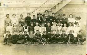
East Burnaby Public School
https://search.heritageburnaby.ca/link/museumdescription4033
- Repository
- Burnaby Village Museum
- Date
- 1910
- Collection/Fonds
- Burnaby Village Museum Photograph collection
- Description Level
- Item
- Physical Description
- 1 photograph : sepia ; 9.3 x 14.5 cm
- Scope and Content
- Item is a photographic postcard of a class from East Burnaby School (Edmonds Street School) taken outside the school building. There are nineteen boys and seventeen girls sitting and standing in three rows, with their teacher standing in the centre at the back. Six of the boys seated at the front…
- Repository
- Burnaby Village Museum
- Collection/Fonds
- Burnaby Village Museum Photograph collection
- Description Level
- Item
- Physical Description
- 1 photograph : sepia ; 9.3 x 14.5 cm
- Scope and Content
- Item is a photographic postcard of a class from East Burnaby School (Edmonds Street School) taken outside the school building. There are nineteen boys and seventeen girls sitting and standing in three rows, with their teacher standing in the centre at the back. Six of the boys seated at the front are holding lacrosse sticks. Female student on far left of back row is identified as either Ethel or Stella Buskins.
- Subjects
- Buildings - Schools
- Occupations - Teachers
- Sports - Lacrosse
- Persons - Black Canadians
- Persons - Students
- Names
- Edmonds Community School
- Geographic Access
- Edmonds Street
- Street Address
- 7641 Edmonds Street
- Accession Code
- BV017.17.35
- Access Restriction
- No restrictions
- Reproduction Restriction
- No known restrictions
- Date
- 1910
- Media Type
- Photograph
- Historic Neighbourhood
- Edmonds (Historic Neighbourhood)
- Planning Study Area
- Edmonds Area
- Scan Resolution
- 600
- Scan Date
- 01/09/2017
- Notes
- Title based on contents of photograph.
- The postcard is stamped on the front in red ink, "East BURNABY. PUBLIC SCHOOL".
- The postcard is inscribed on the front in printing, in ink, "1910"
Images


Nicholson Farm
https://search.heritageburnaby.ca/link/archivedescription38255
- Repository
- City of Burnaby Archives
- Date
- 1910
- Collection/Fonds
- Burnaby Historical Society fonds
- Description Level
- Item
- Physical Description
- 1 photograph : b&w ; 10.2 x 15.2 cm
- Scope and Content
- Photograph of the home and barns at the farm of E.W. Nicholson and Elsie Nicholson.
- Repository
- City of Burnaby Archives
- Date
- 1910
- Collection/Fonds
- Burnaby Historical Society fonds
- Subseries
- Margaret McCallum subseries
- Physical Description
- 1 photograph : b&w ; 10.2 x 15.2 cm
- Description Level
- Item
- Record No.
- 375-017
- Access Restriction
- No restrictions
- Reproduction Restriction
- No known restrictions
- Accession Number
- BHS1986-42
- Scope and Content
- Photograph of the home and barns at the farm of E.W. Nicholson and Elsie Nicholson.
- Media Type
- Photograph
- Notes
- Title based on contents of photograph
- A note on the back of the photograph reads: "Home of E.W. Nicholson 1900-1951 and Elsie Nicholson 1934-1951. Boundary Road and Great Northern Railway. Property sold to Link-Belt Co. in 1951."
- Geographic Access
- Boundary Road
- Street Address
- 2550 Boundary Road
- Historic Neighbourhood
- Broadview (Historic Neighbourhood)
- Planning Study Area
- West Central Valley Area
Images

![Deer Lake Drive, [1918] thumbnail](/media/hpo/_Data/_BVM_Images/1972/1972_0051_0012_001.jpg?width=280)
Deer Lake Drive
https://search.heritageburnaby.ca/link/museumdescription1085
- Repository
- Burnaby Village Museum
- Date
- [1918]
- Collection/Fonds
- Burnaby Village Museum Photograph collection
- Description Level
- Item
- Physical Description
- 1 photograph : b&w ; 12.9 x 32.9 cm
- Scope and Content
- Photograph is a panorama of Deer Lake Drive, including the Ceperley mansion and the surrounding grounds of the home to the left of the picture. The photograph, taken from the water tower, with Burnaby Lake in the background. In the midground, following the horizon line, power poles can be seen. Far…
- Repository
- Burnaby Village Museum
- Collection/Fonds
- Burnaby Village Museum Photograph collection
- Description Level
- Item
- Physical Description
- 1 photograph : b&w ; 12.9 x 32.9 cm
- Scope and Content
- Photograph is a panorama of Deer Lake Drive, including the Ceperley mansion and the surrounding grounds of the home to the left of the picture. The photograph, taken from the water tower, with Burnaby Lake in the background. In the midground, following the horizon line, power poles can be seen. Farm lands are visible leading down to the homes of the Andersons. An annotation on the back of the photo in pencil reads, "Deer Lake Dr." and an annotation in blue pen reads, "1918."
- Geographic Access
- Deer Lake Drive
- Deer Lake Avenue
- Street Address
- 6344 Deer Lake Avenue
- Accession Code
- HV972.51.12
- Access Restriction
- No restrictions
- Reproduction Restriction
- No known restrictions
- Date
- [1918]
- Media Type
- Photograph
- Historic Neighbourhood
- Burnaby Lake (Historic Neighbourhood)
- Planning Study Area
- Douglas-Gilpin Area
- Scan Resolution
- 600
- Scan Date
- 2023-04-04
Images
![Deer Lake Drive, [1918] thumbnail](/media/hpo/_Data/_BVM_Images/1972/1972_0051_0012_001.jpg)
![Hill farm, [1915] thumbnail](/media/hpo/_Data/_Archives_Images/_Unrestricted/477/477-653.jpg?width=280)
Hill farm
https://search.heritageburnaby.ca/link/archivedescription39334
- Repository
- City of Burnaby Archives
- Date
- [1915]
- Collection/Fonds
- Peers Family and Hill Family fonds
- Description Level
- Item
- Physical Description
- 2 photographs : b&w ; 5 x 10.5 cm on page 24.5 x 32.5 cm (pasted in album and joined to form one panorama)
- Scope and Content
- Photograph of the Hill family farm near Deer Lake. The panorama shows the buildings and fields and off to the right can be seen the Pole Line Road (Sperling Avenue).
- Repository
- City of Burnaby Archives
- Date
- [1915]
- Collection/Fonds
- Peers Family and Hill Family fonds
- Physical Description
- 2 photographs : b&w ; 5 x 10.5 cm on page 24.5 x 32.5 cm (pasted in album and joined to form one panorama)
- Description Level
- Item
- Record No.
- 477-653
- Access Restriction
- No restrictions
- Reproduction Restriction
- No known restrictions
- Accession Number
- 2007-12
- Scope and Content
- Photograph of the Hill family farm near Deer Lake. The panorama shows the buildings and fields and off to the right can be seen the Pole Line Road (Sperling Avenue).
- Media Type
- Photograph
- Notes
- Title based on contents of photograph
- Geographic Access
- Sperling Avenue
- Historic Neighbourhood
- Burnaby Lake (Historic Neighbourhood)
- Planning Study Area
- Morley-Buckingham Area
Images
![Hill farm, [1915] thumbnail](/media/hpo/_Data/_Archives_Images/_Unrestricted/477/477-653.jpg)

McKenzie family home
https://search.heritageburnaby.ca/link/archivedescription37034
- Repository
- City of Burnaby Archives
- Date
- 1912 (date of original), copied 1992
- Collection/Fonds
- Burnaby Historical Society fonds
- Description Level
- Item
- Physical Description
- 1 photograph : b&w ; 7.6 x 12.6 cm print
- Scope and Content
- Photograph of the McKenzie family home and farm on Laurier Street (now Halligan Street).
- Repository
- City of Burnaby Archives
- Date
- 1912 (date of original), copied 1992
- Collection/Fonds
- Burnaby Historical Society fonds
- Subseries
- Burnaby Centennial Anthology subseries
- Physical Description
- 1 photograph : b&w ; 7.6 x 12.6 cm print
- Description Level
- Item
- Record No.
- 315-497
- Access Restriction
- No restrictions
- Reproduction Restriction
- No known restrictions
- Accession Number
- BHS1994-04
- Scope and Content
- Photograph of the McKenzie family home and farm on Laurier Street (now Halligan Street).
- Media Type
- Photograph
- Notes
- Title based on contents of photograph
- Geographic Access
- Halligan Street
- Historic Neighbourhood
- Edmonds (Historic Neighbourhood)
- Planning Study Area
- Morley-Buckingham Area
Images


McKenzie family home
https://search.heritageburnaby.ca/link/archivedescription37039
- Repository
- City of Burnaby Archives
- Date
- 1912 (date of original), copied 1992
- Collection/Fonds
- Burnaby Historical Society fonds
- Description Level
- Item
- Physical Description
- 1 photograph : b&w ; 8.1 x 12.1 cm print
- Scope and Content
- Photograph of the McKenzie family home and farm on Laurier Street (now Halligan Street) with added rooms at the back and a strawberry patch in front.
- Repository
- City of Burnaby Archives
- Date
- 1912 (date of original), copied 1992
- Collection/Fonds
- Burnaby Historical Society fonds
- Subseries
- Burnaby Centennial Anthology subseries
- Physical Description
- 1 photograph : b&w ; 8.1 x 12.1 cm print
- Description Level
- Item
- Record No.
- 315-502
- Access Restriction
- No restrictions
- Reproduction Restriction
- No known restrictions
- Accession Number
- BHS1994-04
- Scope and Content
- Photograph of the McKenzie family home and farm on Laurier Street (now Halligan Street) with added rooms at the back and a strawberry patch in front.
- Media Type
- Photograph
- Notes
- Title based on contents of photograph
- Geographic Access
- Halligan Street
- Historic Neighbourhood
- Edmonds (Historic Neighbourhood)
- Planning Study Area
- Morley-Buckingham Area
Images


McKenzie family home and farm
https://search.heritageburnaby.ca/link/archivedescription37035
- Repository
- City of Burnaby Archives
- Date
- 1912 (date of original), copied 1992
- Collection/Fonds
- Burnaby Historical Society fonds
- Description Level
- Item
- Physical Description
- 1 photograph : b&w ; 8.6 x 12.7 cm print
- Scope and Content
- Photograph of the McKenzie family home and farm on Laurier Street (now Halligan Street). Cows can be seen in the background and a girl in the foreground.
- Repository
- City of Burnaby Archives
- Date
- 1912 (date of original), copied 1992
- Collection/Fonds
- Burnaby Historical Society fonds
- Subseries
- Burnaby Centennial Anthology subseries
- Physical Description
- 1 photograph : b&w ; 8.6 x 12.7 cm print
- Description Level
- Item
- Record No.
- 315-498
- Access Restriction
- No restrictions
- Reproduction Restriction
- No known restrictions
- Accession Number
- BHS1994-04
- Scope and Content
- Photograph of the McKenzie family home and farm on Laurier Street (now Halligan Street). Cows can be seen in the background and a girl in the foreground.
- Media Type
- Photograph
- Notes
- Title based on contents of photograph
- Geographic Access
- Halligan Street
- Historic Neighbourhood
- Edmonds (Historic Neighbourhood)
- Planning Study Area
- Morley-Buckingham Area
Images

![Thrussell farm and barn, [1914] thumbnail](/media/hpo/_Data/_Archives_Images/_Unrestricted/251/275-009.jpg?width=280)
Thrussell farm and barn
https://search.heritageburnaby.ca/link/archivedescription36477
- Repository
- City of Burnaby Archives
- Date
- [1914]
- Collection/Fonds
- Burnaby Historical Society fonds
- Description Level
- Item
- Physical Description
- 1 photograph : b&w ; 8.5 x 12.5 cm print
- Scope and Content
- Photograph of the Thrussell family farm, including the front gate and barn on Marine Drive, at Nelson Avenue.
- Repository
- City of Burnaby Archives
- Date
- [1914]
- Collection/Fonds
- Burnaby Historical Society fonds
- Subseries
- Thrussell family subseries
- Physical Description
- 1 photograph : b&w ; 8.5 x 12.5 cm print
- Description Level
- Item
- Record No.
- 275-009
- Access Restriction
- No restrictions
- Reproduction Restriction
- No known restrictions
- Accession Number
- BHS1992-05
- Scope and Content
- Photograph of the Thrussell family farm, including the front gate and barn on Marine Drive, at Nelson Avenue.
- Names
- North Arm Dairy
- Media Type
- Photograph
- Notes
- Title based on contents of photograph
- Geographic Access
- Marine Drive
- Nelson Avenue
- Historic Neighbourhood
- Fraser Arm (Historic Neighbourhood)
- Planning Study Area
- Big Bend Area
Images
![Thrussell farm and barn, [1914] thumbnail](/media/hpo/_Data/_Archives_Images/_Unrestricted/251/275-009.jpg)