Narrow Results By
Subject
- Adornment - Lapel Pins 1
- Advertising Medium 2
- Advertising Medium - Flyer 1
- Advertising Medium - Poster 1
- Advertising Medium - Signs and Signboards 1
- Building Components 1
- Buildings - Judicial - Courthouses 1
- Celebrations 3
- Celebrations - Centennials 9
- Ceremonial Artifacts 2
- Ceremonies 1
- Clothing - Accessory 1
Person / Organization
- Air Raid Precautions (A.R.P.) 1
- British Columbia Electric Railway Company 1
- Burnaby Centennial '71 Committee 8
- Burnaby Village Museum 13
- Canada Summer Games 1
- Century Park Museum Association 5
- Cutress, Harry Charles 1
- Galbraith, Eleanor Lois 1
- G.F. and J. Galt Limited 1
- Girl Guides of Canada 4
- Love Family 1
- Love, Jesse, 1849-1928 1

William Holmes House
https://search.heritageburnaby.ca/link/landmark736
- Repository
- Burnaby Heritage Planning
- Geographic Access
- North Road
- Brunette River
- Associated Dates
- 1860
- Heritage Value
- William Holmes is considered to be the first non-Native resident of Burnaby. In March, 1860, Holmes acquired the first land title in the area that would become the Municipality of Burnaby. Legally known as Lot One, Block One, this parcel was located on North Road and the Brunette River. The eight-member Holmes family built a log cabin on the lot on a bluff above the river in which they lived for many years until a bigger home was built. The log cabin remained and in 1892 was used as an isolation hospital when a smallpox epidemic hit the lower mainland. Afterwards, local health officials burned the cabin to prevent the spread of disease.
- Planning Study Area
- Cariboo-Armstrong Area
Images


St. Nicholas Anglican Church
https://search.heritageburnaby.ca/link/landmark641
- Repository
- Burnaby Heritage Planning
- Description
- Church building.
- Associated Dates
- 1912
- Street View URL
- Google Maps Street View
- Repository
- Burnaby Heritage Planning
- Geographic Access
- Triumph Street
- Associated Dates
- 1912
- Description
- Church building.
- Heritage Value
- This church was one of the first built in North Burnaby to serve the new community of Vancouver Heights. Designed by architect Frank Barrs and constructed by local builders, Arthur England and Mr. Scott, it reflected the English roots of the Anglican Church with its fine Arts and Crafts style. It was officially opened in an impressive ceremony by the Bishop of New Westminster and could accommodate 200 worshippers. It was named after Saint Nicholas, the patron saint of sailors. The adjoining parish hall was completed in 1920. The church building features a gabled roof, triangular eave brackets and a semi-octagonal apse. Stucco has been applied to the exterior, but it retains its original form, scale and massing. It now houses the Burnaby Pacific Grace Church. English-born Frank Barrs (1871-1963) arrived in Vancouver in 1907 and established an office for about one year before he began working for the Vancouver Exhibition Association. He briefly established a partnership (1912-1913) with Samuel Shewbrooks (1877-1957), and was active as an architect until about 1933.
- Locality
- Vancouver Heights
- Historic Neighbourhood
- Vancouver Heights (Historic Neighbourhood)
- Planning Study Area
- Burnaby Heights Area
- Architect
- Frank A.A. Barrs
- Area
- 1695.45
- Contributing Resource
- Building
- Ownership
- Private
- Street Address
- 3883 Triumph Street
- Street View URL
- Google Maps Street View
Images


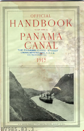
pamphlet
https://search.heritageburnaby.ca/link/museumartifact6576
- Repository
- Burnaby Village Museum
- Accession Code
- BV985.83.3
- Description
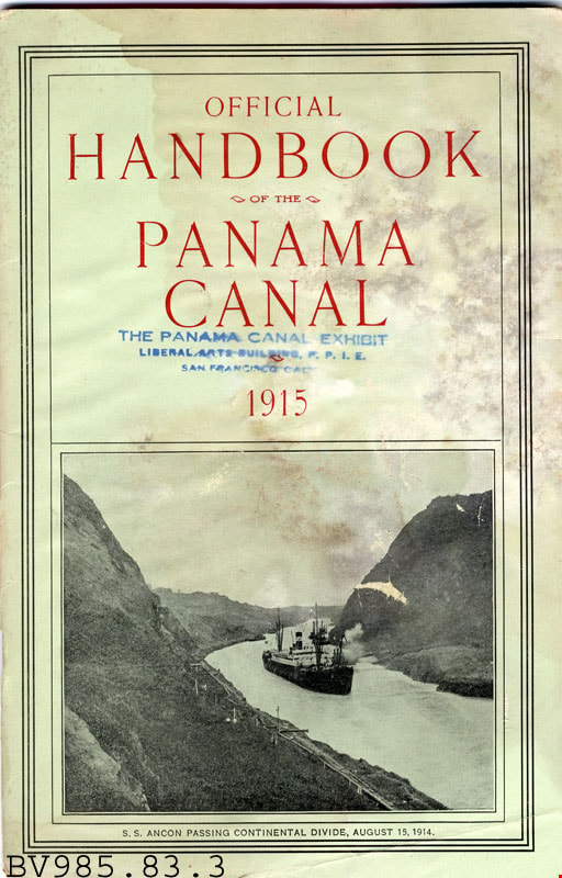
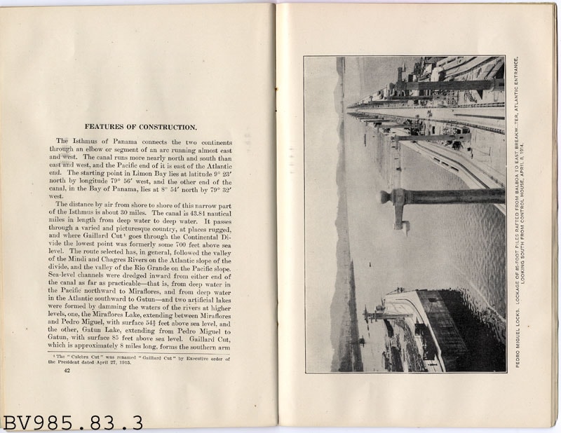
- Official Handbook of the Panama Canal - Booklet -- [1915]. Booklet created by the Washington Government Printing Office. The booklet provides information about shipping facilities, distance saved, cost saving of the canal, tolls, traffic routes, and the Navy's use of the canal. The cover of the booklet is light green with a photograph of a ship passing through the calan. The title of the booklet is printed in red. The cover has been stamped by The Panama Canal Exhibit in San Francisco.
- Country Made
- United States of America
- Province Made
- District of Columbia
- Site/City Made
- Washington
- Title
- Official Handbook of the Panama Canal
- Publication Date
- 1915
Images

Confederation Park
https://search.heritageburnaby.ca/link/landmark672
- Repository
- Burnaby Heritage Planning
- Geographic Access
- Willingdon Avenue
- Associated Dates
- 1927
- Heritage Value
- North Burnaby’s first park began its life as the Capitol Hill subdivision during the land boom of 1909. In 1914 the boom went bust and many owners of unoccupied lots failed to pay the property taxes owing and the land became the property of the Municipality of Burnaby. By 1922, Burnaby had so many lots that it decided to reserve land for future park use and dedicated a narrow 26 acre site adjacent to the ravine. During the 1920s, the Heights area boomed again and many new residents wanted a playground for their children. A local women’s group took on the cause and enlisted local residents and businesses to raise the necessary funds. On June 25, 1927 crowds gathered to officially dedicate “Confederation Park” named in honour of the Diamond Jubilee of Canada’s Confederation (1867-1927).
- Historic Neighbourhood
- Capitol Hill (Historic Neighbourhood)
- Planning Study Area
- Capitol Hill Area
- Street Address
- 250 Willingdon Avenue
- Street View URL
- Google Maps Street View
Images

program
https://search.heritageburnaby.ca/link/museumartifact81780
- Repository
- Burnaby Village Museum
- Accession Code
- BV009.12.1
- Description
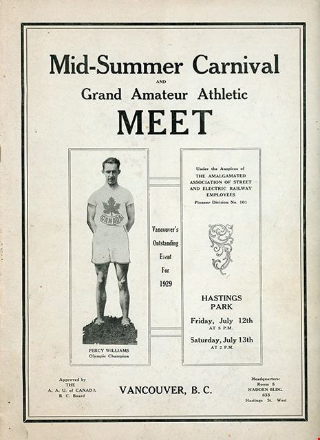
- Souvenir program for "Mid-Summer Carnival / AND / Grand Amateur Athletic / Meet / UNDER THE AUSPICES OF / THE AMALGAMATED ASSOICATION OF STREET AND ELECTRIC RAILWAY EMPLOYEES / PIONEER DIVISION NO. 101 / VANCOUVER, B. C., FRIDAY, JULY 12TH, at 5 P.M. / and SATURDAY, JULY 13TH, at 2 P.M. / HASTINGS PARK / VANCOUVER'S OUTSTANDING EVENT FOR 1929" printed on the facing page of the program. Program consists of 32 pages inside a blue tinted cover, stapled binding. Program includes a list of officials, list of events, list of participants along with photographs, illustrations and advertising. Handwritten annotations are visible on the list of officials and the events pages. Program is "Approved by / THE / A.A.U. of CANADA / B.C. Board / Headquarters: Room 5 / HADDEN BLDG. / 633 / Hastings St. West"
- Object History
- Item belonged to a teacher in Steveston who attended the event in 1929.
- Category
- 08. Communication Artifacts
- Classification
- Documentary Artifacts - - Other Documents
- Object Term
- Program
- Measurements
- 30.5 cm X 22.5 cm
- Country Made
- Canada
- Province Made
- British Columbia
- Site/City Made
- Vancouver
- Title
- Mid-Summer Carnival and Grand Amateur Athletic Meet
- Publication Date
- 1929
Images

Standard Oil Company / Chevron
https://search.heritageburnaby.ca/link/landmark673
- Repository
- Burnaby Heritage Planning
- Geographic Access
- Willingdon Avenue North
- Associated Dates
- 1935
- Heritage Value
- In 1935 the announcement that the California-based Standard Oil Company was going to build a huge "million dollar" refinery in Burnaby was greeted with cheers by residents who were eager for employment and good news during the Great Depression. The refinery, named Stanovan (aka: Standard Oil - Vancouver) was officially opened in 1936 with the ability to produce 2000 barrels per day. During World War Two, the capacity of the refinery doubled to assist in the war effort. In 1976, the company's name was changed to Chevron Canada Limited.
- Historic Neighbourhood
- Vancouver Heights (Historic Neighbourhood)
- Planning Study Area
- Burnaby Heights Area
- Street Address
- 355 Willingdon Avenue North
Images


Barnet Mountain Park Dedication
https://search.heritageburnaby.ca/link/landmark686
- Repository
- Burnaby Heritage Planning
- Associated Dates
- 1942
- Heritage Value
- For years, the idea of creating a park on Burnaby Mountain was favoured by people in Burnaby. In 1930, the Municipal Engineer submitted a report recommending that the city acquire land in the area with a view towards formally dedicating the space for public use. In 1942, Commissioner Richard Bolton enacted Bylaw 1772 which officially dedicated the mountain as public park.
- Historic Neighbourhood
- Barnet (Historic Neighbourhood)
- Planning Study Area
- Burnaby Mountain Area
Images


Burnaby Municipal Hall
https://search.heritageburnaby.ca/link/landmark807
- Repository
- Burnaby Heritage Planning
- Geographic Access
- Canada Way
- Associated Dates
- 1956
- Heritage Value
- When staff outgrew the municipal buildings at Edmonds and Kingsway, a debate erupted over where to build a new municipal hall. North Burnaby residents argued against the Kingsway and Edmonds site as it was too removed for their needs, but South Burnaby residents were not prepared to accept a hall in North Burnaby. The debate was finally resolved when it was suggested that the new civic centre for the municipality be in the exact geographic centre of Burnaby. Fortunately, this meant that the new hall was to be built near Deer Lake, in the beautiful Central Valley setting. Burnaby voters accepted this decision and approved the $625,000.00 it would take to build the new structure and the official opening ceremony was held June 22, 1956 when then Reeve Charles MacSorley received the keys to the hall from the contractor.
- Historic Neighbourhood
- Burnaby Lake (Historic Neighbourhood)
- Planning Study Area
- Douglas-Gilpin Area
- Street Address
- 4949 Canada Way
- Street View URL
- Google Maps Street View
Images

pamphlet
https://search.heritageburnaby.ca/link/museumartifact39273
- Repository
- Burnaby Village Museum
- Accession Code
- BV998.45.1
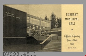
- Description
- Burnaby Municipal Hall - Pamphlet -- [1956]. Pamphlet for the Official Opening of the Burnaby Municipal Hall on June 22nd, 1956 at 2pm. The front cover of the pamphlet has a black and white photograph of the new municipal hall building. The pamphlet includes a brief history of the municipal halls in Burnaby, a program of events for the day, photographs of various spaces in the new hall and a floor plan. On the back cover is the District of Burnaby seal logo with the cornucopia. The pamphlet was printed by Printcarft of B.C. Limited and Allied Printing in New Westminster.
- Category
- 08. Communication Artifacts
- Classification
- Documentary Artifacts - - Other Documents
- Object Term
- Program
- Measurements
- Overall measurements: 21.5cm wide x 12.5cm high
- Title
- Burnaby Municipal Hall Official Opening
- Publication Date
- 1956
- Subjects
- Events
- Celebrations
Images


Swangard Stadium
https://search.heritageburnaby.ca/link/landmark818
- Repository
- Burnaby Heritage Planning
- Geographic Access
- Imperial Street
- Associated Dates
- 1969
- Heritage Value
- On 26 April 1969 Swangard Stadium held its official opening. Named after Vancouver Sun former Managing Editor, Erwin Swangard, the stadium was funded entirely from private donations and civic and provincial grants.
- Historic Neighbourhood
- Central Park (Historic Neighbourhood)
- Planning Study Area
- Maywood Area
- Street Address
- 3883 Imperial Street
Images


Mortimer-Lamb House
https://search.heritageburnaby.ca/link/landmark494
- Repository
- Burnaby Heritage Planning
- Description
- The Mortimer-Lamb House is a one and one half-storey, Arts and Crafts-style residence with a steeply pitched, side-gabled roof. The original cottage form has been enlarged with a later addition on the west side of the house. Located next to the Burnaby Lake Regional Park Wildlife Rescue Care Centre…
- Associated Dates
- c.1922
- Formal Recognition
- Community Heritage Register
- Other Names
- Harold & Katherine Mortimer-Lamb Residence
- Street View URL
- Google Maps Street View
- Repository
- Burnaby Heritage Planning
- Other Names
- Harold & Katherine Mortimer-Lamb Residence
- Geographic Access
- Glencarin Drive
- Associated Dates
- c.1922
- Formal Recognition
- Community Heritage Register
- Enactment Type
- Council Resolution
- Enactment Date
- 26/05/2003
- Description
- The Mortimer-Lamb House is a one and one half-storey, Arts and Crafts-style residence with a steeply pitched, side-gabled roof. The original cottage form has been enlarged with a later addition on the west side of the house. Located next to the Burnaby Lake Regional Park Wildlife Rescue Care Centre, the house has picturesque views of Burnaby Lake.
- Heritage Value
- Built circa 1922, the Mortimer-Lamb House is valued for its association with first owners, Harold Mortimer-Lamb (1872-1970), and his wife, Katherine Mary Mortimer-Lamb (1873-1939). Born in Leatherhead, Surrey, England, Harold Mortimer-Lamb immigrated to Canada in 1889. Seven years later in Vancouver, he married Katherine Mary Lindsay, a native of Winnipeg. Mortimer-Lamb was a key figure in the B.C. mining industry, serving as Secretary of the Mining Association of B.C. between 1900 and 1945, and also as the Secretary of the Canadian Institute of Mining and Metallurgy. In addition to his professional life, Mortimer-Lamb was a pioneer art photographer and was among Canada's leading art critics, and this house served as a central gathering place for renowned Canadian artists of the day. Mortimer-Lamb’s daughter, Molly Lamb Bobak (born 1922), became a renowned watercolourist, and was the only woman ever hired as an official Canadian war artist. The Mortimer-Lamb House is a significant example of the work of noted architect, Samuel Maclure (1860-1929) and his partner, Ross Lort (1889-1969). Maclure, who was a close friend of the Mortimer-Lamb family, was British Columbia's leading residential architect, and was renowned for his high quality designs for prominent citizens in both Vancouver and Victoria. Maclure was a leading exponent of the Art and Crafts design movement in B.C., and established a sophisticated local variation of residential architecture. The Mortimer-Lamb House was designed at the time when Maclure was in partnership with Ross Lort. In 1907, Lort began working for Maclure's firm as a draftsman, and by 1920 was in charge of Maclure's Vancouver office. Lort's architectural career spanned some sixty-years, and he designed some of the province's most familiar houses, apartments, institutions and places of worship. The Mortimer-Lamb House is also a significant local example of the Arts and Crafts style, and incorporates elements such as board-and-batten siding on the ground floor, shingled gables and leaded casement windows. It is a testament to the domestic architecture built outside of established suburbs during the post-First World War era, typically modest in scale and representative of middle-class residential ideals.
- Defining Elements
- Key elements that define the heritage character of the Mortimer-Lamb House include its: - treed setting with views of Burnaby Lake - residential form, scale and massing as expressed by its one and one-half storey height, rectangular plan and steeply pitched side-gabled roof - wood-frame construction - Arts and Crafts elements such as board-and-batten siding on the ground floor, cedar shingles in the gables and open soffits - original straight-leaded casement windows in single and multiple-assembly - internal red-brick chimney with corbelled cap
- Historic Neighbourhood
- Burnaby Lake (Historic Neighbourhood)
- Planning Study Area
- Burnaby Lake Area
- Organization
- Mining Association of B.C.
- G.F. and J. Galt Limited
- Architect
- Samuel Maclure
- Ross Lort
- Function
- Primary Historic--Single Dwelling
- Primary Current--Single Dwelling
- Community
- Burnaby Lake
- Cadastral Identifier
- P.I.D.002-977-788
- Boundaries
- The Mortimer-Lamb House is comprised of a single residential lot located at 5180 Glencairn Drive, Burnaby.
- Area
- 5652.78
- Contributing Resource
- Building
- Ownership
- Private
- Documentation
- City of Burnaby Planning and Building Department, Heritage Site Files
- Street Address
- 5180 Glencarin Drive
- Street View URL
- Google Maps Street View
Images


Brentwood Neighbourhood
https://search.heritageburnaby.ca/link/landmark780
- Repository
- Burnaby Heritage Planning
- Associated Dates
- 1955-2008
- Heritage Value
- Between 1955 and 2001, the Brentwood Neighbourhood developed into one of Burnaby's four official Town Centres. The Brentwood Town Centre serves the north-west sector of the Municipality, providing facilities such as commercial developments - of which the Brentwood Mall is the most significant. Under Burnaby's Residential Development Framework adopted by Council in 1981, the Town Centre also incorporated a full range of multi-housing types and forms in close relationship with their commercial facilities. In 1996, the City adopted the Brentwood Town Centre Development Plant to solidify the area as a focus of higher-density and higher-intensity residential and commercial opportunities, public transit and supporting leisure facilities.
- Planning Study Area
- Brentwood Area
Images


Richmond Park Neighbourhood
https://search.heritageburnaby.ca/link/landmark828
- Repository
- Burnaby Heritage Planning
- Associated Dates
- 1955-2008
- Heritage Value
- The Richmond Park Neighbourhood is part of the larger Edmonds Town Centre - one of four official Town Centres in the City. Richmond Park contains a residential subdivision that developed during the 1950s as well as a strong commercial and retail centre along Edmonds and Kingsway.
- Historic Neighbourhood
- Edmonds (Historic Neighbourhood)
- Planning Study Area
- Richmond Park Area
Images

certificate
https://search.heritageburnaby.ca/link/museumartifact6663
- Repository
- Burnaby Village Museum
- Accession Code
- BV985.99.8
- Description
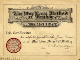
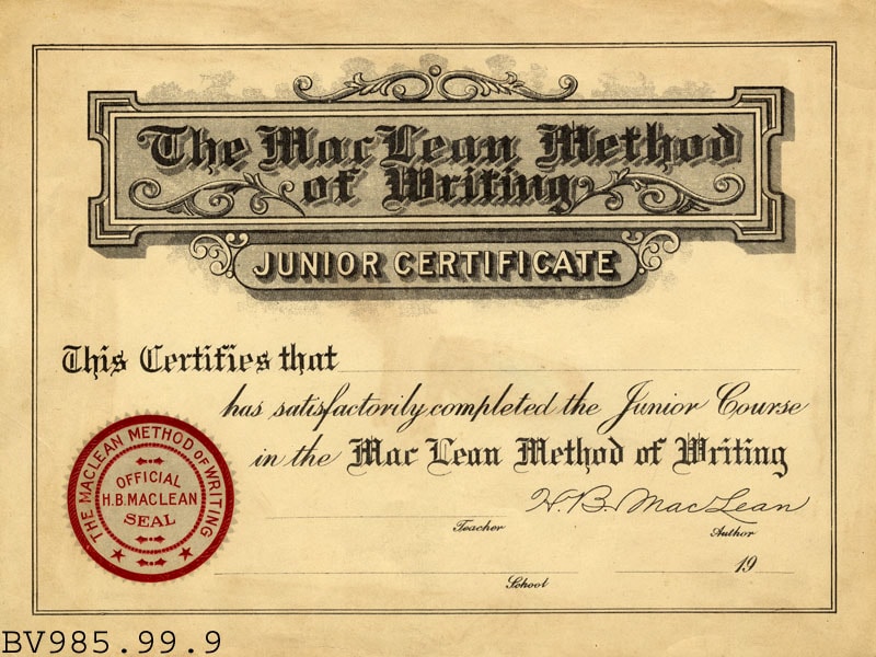
- The MacLean Method of Writing - Certificate -- [19--?]. Blank certificate for the Junior course for the MacLean Method of Writing. The ceritifcate has the Official H.B. MacLean Seasl in red embossed on the bottom left corner. The certificate has blank spots for the student's name, teacher's name, and name of the school.
Images
memorial drinking fountain
https://search.heritageburnaby.ca/link/museumartifact8784
- Repository
- Burnaby Village Museum
- Accession Code
- BV985.1242.1
- Description
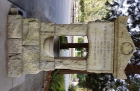
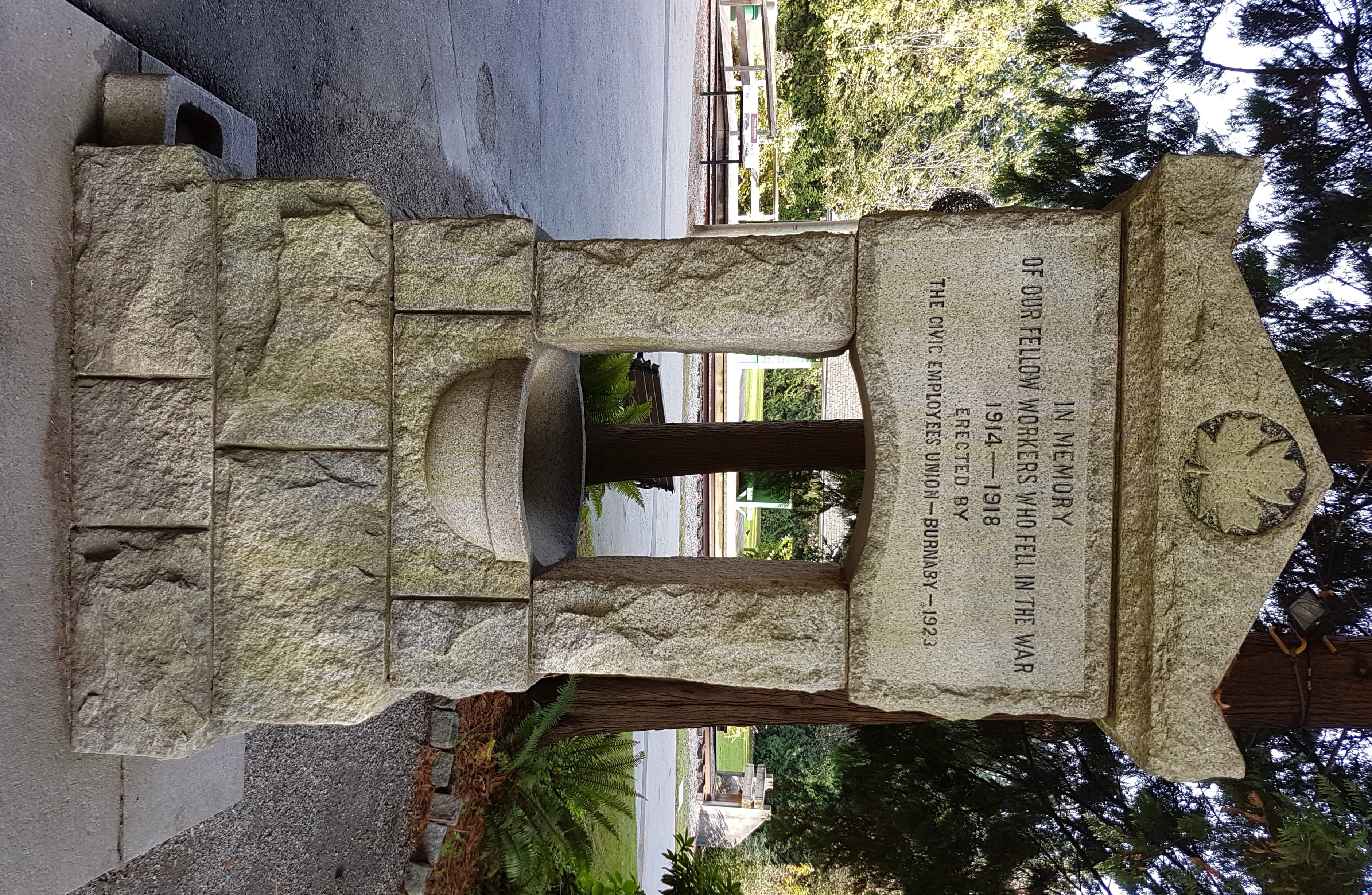
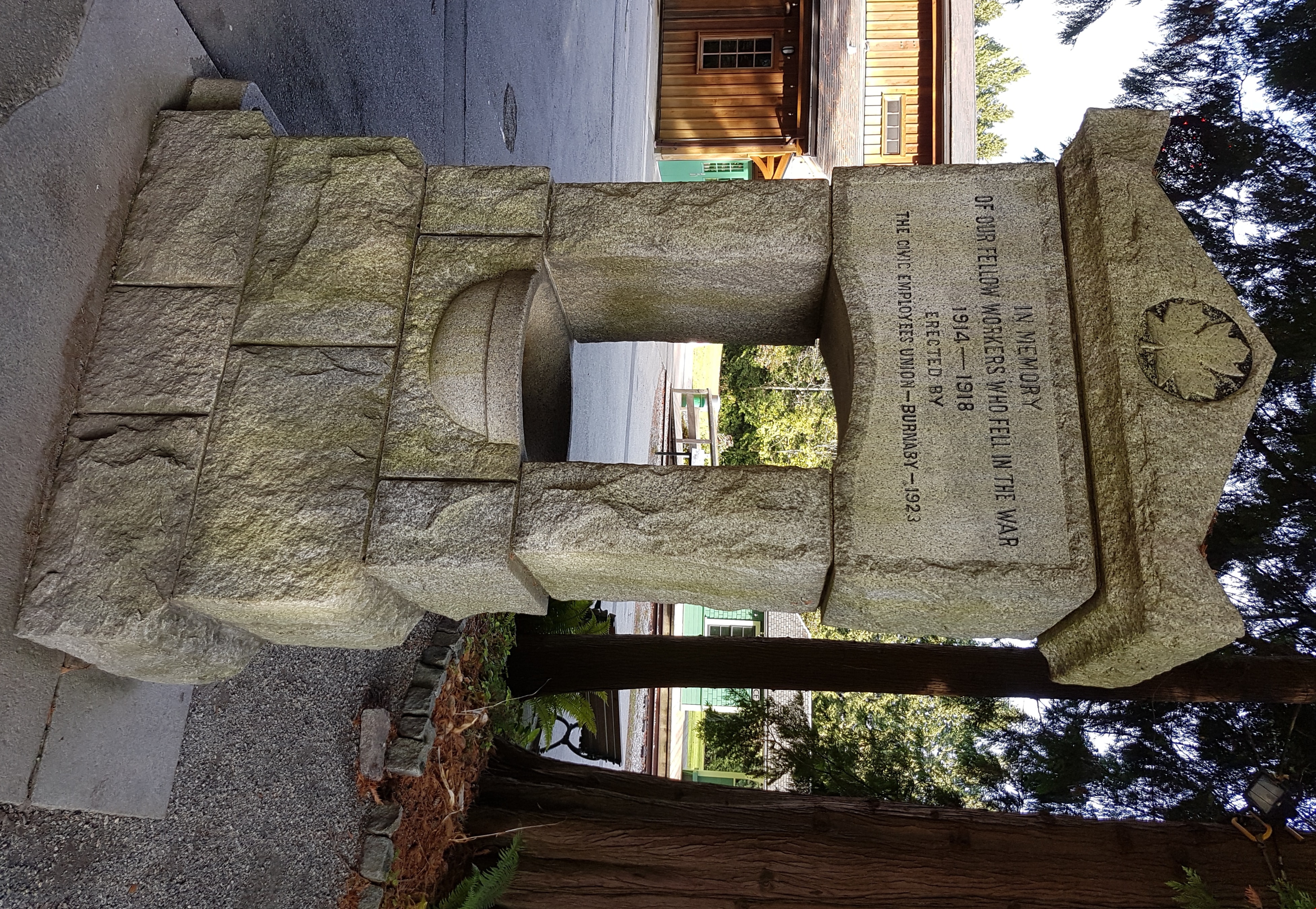
- The Memorial fountain is made of British Columbia granite. The fountain is currently three courses of rough stone, leading up to the smooth water bowl. Two side pillars carry the memorial stone and the peaked cap stone at the top. The memorial stone's face is smooth, to present the cut text of the memorial. There is a maple leaf cut into the face of the cap stone. The text and the maple leaf are highlighted with black paint. There is a small block at the rear of the fountain to allow children easy access and there is a smooth stone drinking bowl for animals at the proper right of the base of the fountain. The fountain on its original site was four courses high. In its current site the bottom course is set level with the ground. The main bowl is supplied with running water but the animal bowl is dry.
- Object History
- The fountain was erected by the Burnaby Civic Employees Union (now CUPE Local 23) and is dedicated to Union members who died in the Great War. Local stonemason, William Williamson, constructed the fountain in 1923 and it was unveiled on June 17, 1923. In 1977, the fountain was moved and rededicated from the old Burnaby Municipal Hall site to its current site at Burnaby Village Museum. On November 23, 1992, the fountain was given official Heritage Designation by Bylaw # 9807, Municipality of Burnaby
- Marks/Labels
- "IN MEMEORY / OF OUR FELLOW WORKERS WHO FELL IN THE WAR / 1914 - 1918 / ERECTED BY / THE CIVIC EMPLOYEES UNION - BURNABY - 1923", cut into the smoothed face of the memorial stone on the fountain. There is a maple leaf cut into the face of the cap stone on the top of the fountain. The maple leaf motif is also used on veteran grave stones.
- Maker
- William Williamson
- Country Made
- Canada
- Province Made
- British Columbia
- Site/City Made
- Burnaby
- Subjects
- Fountains
- Wars
- Monuments - War Memorials
- Wars - World War, 1914-1918
- Organizations - Unions
- Names
- Williamson, William
Images

program
https://search.heritageburnaby.ca/link/museumartifact14337
- Repository
- Burnaby Village Museum
- Accession Code
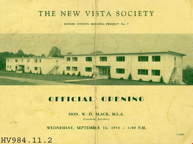
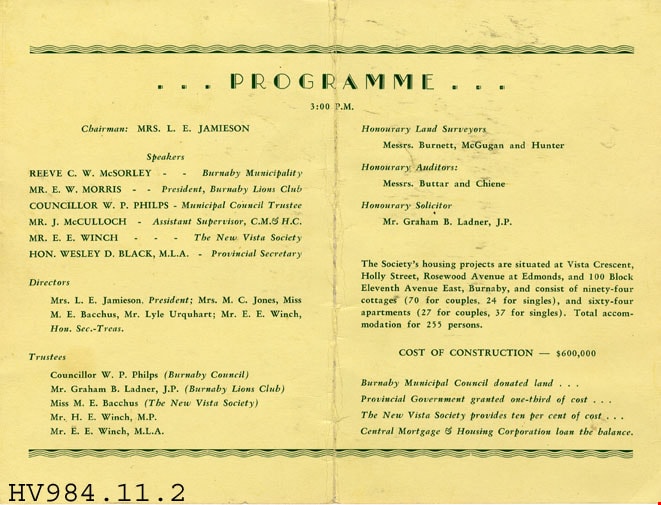
- HV984.11.2
- Description
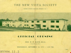
- The New Vista Society - Program -- [1955]. Program for the official opening of The New Vista Society Senior Citizen Housing Project No. 7. The front cover has a photograph of the new buildings being opened. The event took place on Wednesday, September 14, 1955. The reverse side of the program outlines the different parties involved in the organization of the new buildings including the Burnaby Municipality, Burnaby Lions Club and others.
- Names
- New Vista Society
Images
letter
https://search.heritageburnaby.ca/link/museumartifact34112
- Repository
- Burnaby Village Museum
- Accession Code
- BV991.43.1
- Description
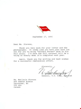
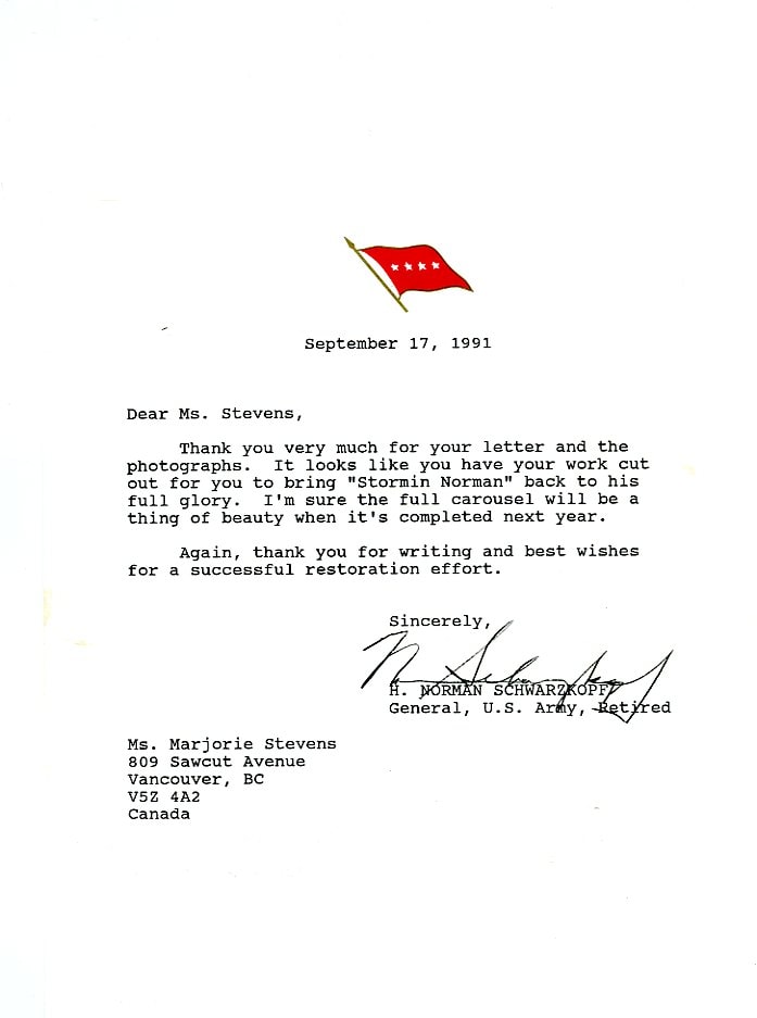
- Stormin' Norman - Letter -- [1991] Letter, with envelope; from General H. Norman Schwartzkopf (U.S. Army, retired) re: carousel horse "Stormin' Norman"; white paper, typed? message; red flying flag at top, four white stars, on gold pole; "September 17, 1991", "Dear Ms. Stevens,..."; envelope addressed to "MS. MARJORIE STEVENS" "809 SAWCUT AVENUE" "VANCOUVER, BC" "V5Z 4A2" "CANADA"; return address "General H. Norman Schwarzkopf, USA (Ret.)" "United States Central Command" "MacDill AFB, FL 33608-7001" "FOR OFFICIAL BUSINESS"; type is not even, some letters are only partly printed; postmarked in red, "MAC DILL A.F.B." "FLA." "SEP 18 '91" "U.S. POSTAGE" "0.40" "METER" "F" "8317187"?; stained at left and right sides
- Colour
- White
Images

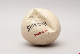
volley ball
https://search.heritageburnaby.ca/link/museumartifact34142
- Repository
- Burnaby Village Museum
- Accession Code
- BV991.45.29
- Description
- Volleyball, cream-coloured, partially deflated; black "OFFICIAL 5 SIZE WEIGHT" in one panel, "SUPERSTAR RVB5" in next panel below; red "NYLON WOUND" in panel below this; worn, scuffed; black dot with hole in centre for inflation, black "5 to 7 LBS" "MOISTEN NEEDLE BEFORE INSERTING" "TAIWAN"
- Object History
- Salvaged from Oakalla Prison site in October 1991
- Names
- Oakalla Prison Farm
Images

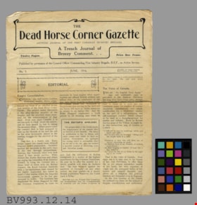
newsletter
https://search.heritageburnaby.ca/link/museumartifact34929
- Repository
- Burnaby Village Museum
- Accession Code
- BV993.12.14
- Description
- The Dead Horse Corner Gazette - Newsletter -- [1916]. The Official Journal of the First Canadian Infantry Brigade called "The Dead Horse Corner Gazette". The journal markets itself as "A Trench Journal of Breezy Comment...". This edition of the journal is Number 3, for June 1916. The journal was published with permission from the General Officer Commanding First Infantry Brigade, B.E.F., on Active Service. There are 12 pages and the journal was priced at one Franc. The journal was printed by John Heywood Limited by Trade Union Labour in Manchester and London. The journal measures 22cm x 27.5cm.
- Maker
- John Heywood Limited
- Country Made
- England
- Site/City Made
- Manchester
- Title
- The Dead Horse Corner Gazette
Images


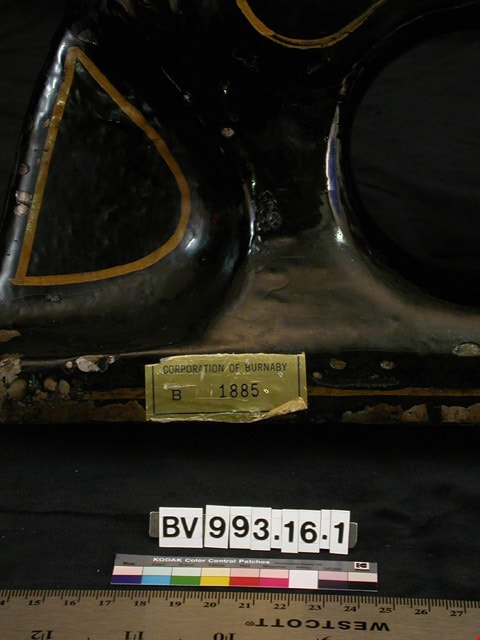
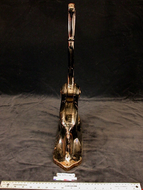
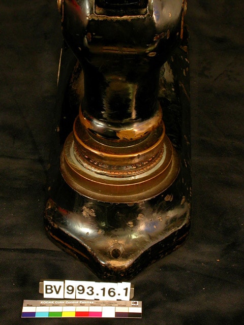
municipal seal
https://search.heritageburnaby.ca/link/museumartifact34938
- Repository
- Burnaby Village Museum
- Accession Code
- BV993.16.1
- Description
- Seal, municipal, official 1898 version for "The District of Burnaby, Incorporated 1892"; with Burnaby Property Identification Sticker No. B1885.
- Object History
- The official municipal seal for the Corporation of the District of Burnaby, used until 1992 when Burnaby became a city.
Images