Narrow Results By
Decade
- 2020s 91
- 2010s 221
- 2000s
- 1990s 542
- 1980s 579
- 1970s 1266
- 1960s 594
- 1950s 463
- 1940s 356
- 1930s 356
- 1920s 535
- 1910s 360
- 1900s 138
- 1890s
- 1880s 26
- 1870s 9
- 1860s 20
- 1850s 8
- 1840s 4
- 1830s 2
- 1820s 2
- 1810s 3
- 1800s 3
- 1790s 3
- 1780s 3
- 1770s 3
- 1760s 3
- 1750s 3
- 1740s 3
- 1730s 3
- 1720s 3
- 1710s 3
- 1700s 3
- 1690s 3
- 1680s 3
- 1670s 2
- 1660s 2
- 1650s 2
- 1640s 2
- 1630s 2
- 1620s 2
- 1610s
- 1600s 2
- 1590s 1
- 1580s 1
- 1570s 1
- 1560s 1
- 1550s 1
- 1540s 1
- 1530s 1
- 1520s 2
- 1510s 1
- 1500s 1
- 1490s 1
- 1480s 1
Creator
- Ames, A. F. (Albert Flintoft) 1
- Anger, William Henry 1
- Baldwin, Joseph, 1827-1899 1
- Bartel, Mario 91
- Baskerville, Peter A. 1
- Bateman, Caroline Mary Wettenhall 1
- Binks, James 8
- Bligh, N. M. (Neville Melton), 1890- 1
- Buckley, Arabella B. (Arabella Burton), 1840-1929 1
- Burnaby Community Heritage Commission 1
- Burnaby, Robert, 1828-1878 1
- Burnaby Village Museum 30
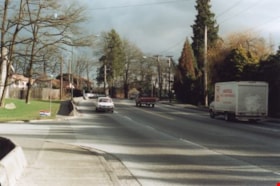
Rayside Drive and Canada Way
https://search.heritageburnaby.ca/link/archivedescription38433
- Repository
- City of Burnaby Archives
- Date
- 2002
- Collection/Fonds
- Burnaby Historical Society fonds
- Description Level
- Item
- Physical Description
- 1 photograph : colour ; 10 x 15 cm
- Scope and Content
- Photograph shows truck driving along Canada Way just past the Rayside Drive intersection.
- Repository
- City of Burnaby Archives
- Date
- 2002
- Collection/Fonds
- Burnaby Historical Society fonds
- Subseries
- Photographs subseries
- Physical Description
- 1 photograph : colour ; 10 x 15 cm
- Description Level
- Item
- Record No.
- 442-001
- Access Restriction
- No restrictions
- Reproduction Restriction
- Reproduce for fair dealing purposes only
- Accession Number
- BHS2007-04
- Scope and Content
- Photograph shows truck driving along Canada Way just past the Rayside Drive intersection.
- Subjects
- Geographic Features - Roads
- Media Type
- Photograph
- Notes
- Title based on contents of photograph.
- Geographic Access
- Canada Way
- Rayside Street
- Historic Neighbourhood
- Burnaby Lake (Historic Neighbourhood)
- Planning Study Area
- Morley-Buckingham Area
Images


Rayside Drive and Canada Way
https://search.heritageburnaby.ca/link/archivedescription39753
- Repository
- City of Burnaby Archives
- Date
- 2002
- Collection/Fonds
- Burnaby Historical Society fonds
- Description Level
- Item
- Physical Description
- 1 photograph : col.; 10 x 15 cm
- Scope and Content
- Photograph of vehicle traffic along Canada Way just past the Rayside Drive intersection.
- Repository
- City of Burnaby Archives
- Date
- 2002
- Collection/Fonds
- Burnaby Historical Society fonds
- Subseries
- Photographs subseries
- Physical Description
- 1 photograph : col.; 10 x 15 cm
- Description Level
- Item
- Record No.
- 442-002
- Access Restriction
- No restrictions
- Reproduction Restriction
- Reproduce for fair dealing purposes only
- Accession Number
- BHS2007-04
- Scope and Content
- Photograph of vehicle traffic along Canada Way just past the Rayside Drive intersection.
- Media Type
- Photograph
- Notes
- Title based on contents of photograph.
- Geographic Access
- Canada Way
- Rayside Street
- Historic Neighbourhood
- Burnaby Lake (Historic Neighbourhood)
- Planning Study Area
- Morley-Buckingham Area
Images

Request for Temporary Signs on Street Right-of-Way Registration Drive for Scouts Canada
https://search.heritageburnaby.ca/link/councilreport4165
- Repository
- City of Burnaby Archives
- Report ID
- 62979
- Meeting Date
- 14-Aug-2000
- Format
- Council - Manager's Report
- Manager's Report No.
- 21
- Item No.
- 5
- Collection/Fonds
- City Council and Office of the City Clerk fonds
- Repository
- City of Burnaby Archives
- Report ID
- 62979
- Meeting Date
- 14-Aug-2000
- Format
- Council - Manager's Report
- Manager's Report No.
- 21
- Item No.
- 5
- Collection/Fonds
- City Council and Office of the City Clerk fonds
Documents
Request for Temporary Signs on Street Rights-of-Way Registration Drive for Scouts Canada
https://search.heritageburnaby.ca/link/councilreport3004
- Repository
- City of Burnaby Archives
- Report ID
- 64150
- Meeting Date
- 8-Jul-2002
- Format
- Council - Manager's Report
- Manager's Report No.
- 19
- Item No.
- 4
- Collection/Fonds
- City Council and Office of the City Clerk fonds
- Repository
- City of Burnaby Archives
- Report ID
- 64150
- Meeting Date
- 8-Jul-2002
- Format
- Council - Manager's Report
- Manager's Report No.
- 19
- Item No.
- 4
- Collection/Fonds
- City Council and Office of the City Clerk fonds
Documents
Request for Temporary Signs on Street Rights-of-Way Registration Drive for Scouts Canada
https://search.heritageburnaby.ca/link/councilreport3611
- Repository
- City of Burnaby Archives
- Report ID
- 63549
- Meeting Date
- 9-Jul-2001
- Format
- Council - Manager's Report
- Manager's Report No.
- 18
- Item No.
- 13
- Collection/Fonds
- City Council and Office of the City Clerk fonds
- Repository
- City of Burnaby Archives
- Report ID
- 63549
- Meeting Date
- 9-Jul-2001
- Format
- Council - Manager's Report
- Manager's Report No.
- 18
- Item No.
- 13
- Collection/Fonds
- City Council and Office of the City Clerk fonds
Documents
Rezoning Reference #00-19 5059 Canada Way Response to Public Hearing Points
https://search.heritageburnaby.ca/link/councilreport3557
- Repository
- City of Burnaby Archives
- Report ID
- 63602
- Meeting Date
- 13-Aug-2001
- Format
- Council - Manager's Report
- Manager's Report No.
- 20
- Item No.
- 4
- Collection/Fonds
- City Council and Office of the City Clerk fonds
- Repository
- City of Burnaby Archives
- Report ID
- 63602
- Meeting Date
- 13-Aug-2001
- Format
- Council - Manager's Report
- Manager's Report No.
- 20
- Item No.
- 4
- Collection/Fonds
- City Council and Office of the City Clerk fonds
Documents
Rezoning Reference #00-19 Split-serve gasoline service station with retail store 5059 Canada Way
https://search.heritageburnaby.ca/link/councilreport3663
- Repository
- City of Burnaby Archives
- Report ID
- 63478
- Meeting Date
- 4-Jun-2001
- Format
- Council - Manager's Report
- Manager's Report No.
- 15
- Item No.
- 10
- Collection/Fonds
- City Council and Office of the City Clerk fonds
- Repository
- City of Burnaby Archives
- Report ID
- 63478
- Meeting Date
- 4-Jun-2001
- Format
- Council - Manager's Report
- Manager's Report No.
- 15
- Item No.
- 10
- Collection/Fonds
- City Council and Office of the City Clerk fonds
Documents
Rezoning Reference #02-16 - Temporary No. 2 Fire Station (7355 Canada Way)
https://search.heritageburnaby.ca/link/councilreport3045
- Repository
- City of Burnaby Archives
- Report ID
- 64112
- Meeting Date
- 17-Jun-2002
- Format
- Council - Manager's Report
- Manager's Report No.
- 17
- Item No.
- 2
- Collection/Fonds
- City Council and Office of the City Clerk fonds
- Repository
- City of Burnaby Archives
- Report ID
- 64112
- Meeting Date
- 17-Jun-2002
- Format
- Council - Manager's Report
- Manager's Report No.
- 17
- Item No.
- 2
- Collection/Fonds
- City Council and Office of the City Clerk fonds
Documents
Road Closure - Canada Day
https://search.heritageburnaby.ca/link/councilreport56021
- Repository
- City of Burnaby Archives
- Report ID
- 77405
- Meeting Date
- 1-Jun-2009
- Format
- Council - Manager's Report
- Item No.
- 16
- Collection/Fonds
- City Council and Office of the City Clerk fonds
- Repository
- City of Burnaby Archives
- Report ID
- 77405
- Meeting Date
- 1-Jun-2009
- Format
- Council - Manager's Report
- Item No.
- 16
- Collection/Fonds
- City Council and Office of the City Clerk fonds
Documents
Road Closure for Canada Day Celebration
https://search.heritageburnaby.ca/link/councilreport3632
- Repository
- City of Burnaby Archives
- Report ID
- 63533
- Meeting Date
- 18-Jun-2001
- Format
- Council - Manager's Report
- Manager's Report No.
- 17
- Item No.
- 9
- Collection/Fonds
- City Council and Office of the City Clerk fonds
- Repository
- City of Burnaby Archives
- Report ID
- 63533
- Meeting Date
- 18-Jun-2001
- Format
- Council - Manager's Report
- Manager's Report No.
- 17
- Item No.
- 9
- Collection/Fonds
- City Council and Office of the City Clerk fonds
Documents
Sale of City Property - 5851 Canada Way
https://search.heritageburnaby.ca/link/councilreport2177
- Repository
- City of Burnaby Archives
- Report ID
- 64978
- Meeting Date
- 3-Nov-2003
- Format
- Council - Manager's Report
- Manager's Report No.
- 29
- Item No.
- 6
- Collection/Fonds
- City Council and Office of the City Clerk fonds
- Repository
- City of Burnaby Archives
- Report ID
- 64978
- Meeting Date
- 3-Nov-2003
- Format
- Council - Manager's Report
- Manager's Report No.
- 29
- Item No.
- 6
- Collection/Fonds
- City Council and Office of the City Clerk fonds
Documents
Siting Approval Application # 107-101; X-Ref. Subdivision Reference # 07-59 - 3775 and 3785 Trans Canada Highway; 3793 Regent Street Request for Subdivision (Myrtle Street Area Plan, Sub-Area 3)
https://search.heritageburnaby.ca/link/councilreport55963
- Repository
- City of Burnaby Archives
- Report ID
- 77337
- Meeting Date
- 27-Apr-2009
- Format
- Council - Manager's Report
- Item No.
- 4
- Collection/Fonds
- City Council and Office of the City Clerk fonds
- Repository
- City of Burnaby Archives
- Report ID
- 77337
- Meeting Date
- 27-Apr-2009
- Format
- Council - Manager's Report
- Item No.
- 4
- Collection/Fonds
- City Council and Office of the City Clerk fonds
Documents
Strata Title Application #05-1; 4400 Still Creek Drive; McDonald's Restaurants of Canada Ltd. (Former Regional Head Office Facility with Drive-In Restaurant Component)
https://search.heritageburnaby.ca/link/councilreport1018
- Repository
- City of Burnaby Archives
- Report ID
- 66129
- Meeting Date
- 3-Oct-2005
- Format
- Council - Manager's Report
- Item No.
- 3
- Collection/Fonds
- City Council and Office of the City Clerk fonds
- Repository
- City of Burnaby Archives
- Report ID
- 66129
- Meeting Date
- 3-Oct-2005
- Format
- Council - Manager's Report
- Item No.
- 3
- Collection/Fonds
- City Council and Office of the City Clerk fonds
Documents

Subdivision plans in New Westminster District Group 1 – Burnaby, Vancouver and map - Canada Department of Mines
https://search.heritageburnaby.ca/link/museumdescription6994
- Repository
- Burnaby Village Museum
- Date
- 1890-1909
- Collection/Fonds
- Burnaby Village Museum Map collection
- Description Level
- File
- Physical Description
- 1 plan : graphite on paper + 2 plans : black ink on paper + 1 map : col. on paper mounted on 2 sides of cardboard 76 x 102 cm
- Scope and Content
- Item consists of a large board with one New Westminster District subdivision plan mounted on one side and two New Westminster District subdivision plans and one colour map mounted on the other side. Side A: 1. "Plan / of Subdivision of / Blocks 2, 3, 4, 5, 6 / Lot 77 / Group 1 / New Westminster D…
- Repository
- Burnaby Village Museum
- Collection/Fonds
- Burnaby Village Museum Map collection
- Description Level
- File
- Physical Description
- 1 plan : graphite on paper + 2 plans : black ink on paper + 1 map : col. on paper mounted on 2 sides of cardboard 76 x 102 cm
- Material Details
- Scales 1:720 and 1:1200 and 1:.00001578
- Scope and Content
- Item consists of a large board with one New Westminster District subdivision plan mounted on one side and two New Westminster District subdivision plans and one colour map mounted on the other side. Side A: 1. "Plan / of Subdivision of / Blocks 2, 3, 4, 5, 6 / Lot 77 / Group 1 / New Westminster District / BC. / Scale 100 feet = 1 inch", "Deposited 8th day / of April 1890 / Mowileg [sic] / Dist. Regt". Plan is drawn in graphite with annotations: "AB_Parts_lettered_are_lots_in / the_different_subdivisions" / "Owners: / James E. Hall / P.S.Cabilan [sic] by his attorney Joseph Hall / Joseph Hall / Eliza J. Shannon / John Harrison"; "This plan is correct and is prepared under the / provisions of the Land Registry Act" ; signed by: "Gordon Herman & Burwell / Dominion & Provincial Land Surveryors / Vancouver March 19th/90" . Plan is initialed by: "RB" [sic] (in blue pencil crayon) and measures: 99.5 x 65 cm (Geographic location: Burnaby) Side B: 1. Map titled "Canada / Department of Mines / Geological Survey Branch" / "Hon.W Templeton, Minister / A.P. Low, Deputy Minister / R.W. Brock, Acting Director", Vol. XXXI, Plate I / Compiled under the direction of / James White, F.R.G.S. Geographer /Dep. of Interior". Note above map reads: "To illustrate Mr. James Barrowman's report as Delegate at the Excursion - meeting of the Canadian Mining Institute", "The instiitution of Mining Engineers / Transactions 1908 - 1909", "The Mining Institute of Scotland / Transactions 1908-1909". Map identifies minerals and includes a Legend and Scale: 100 miles = 1 inch 2. "Plan / of Subdivision of / Lot 4 / of Subdivision of / Lot 87. Gr. 1 / New Westminster District / Scale 60' = 1in." Plan is initialed by: "RB" [sic] along with a note "also Board / 48" (in blue pencil crayon) (Geographic location: Burnaby) 3. Plan of "Lot 335 / G. 1" west of Boundary Road and north of River Road - Vancouver. (Geographic location: Vancouver)
- Publisher
- The Mining Institute of Scotland
- Geographic Access
- Vancouver
- Accession Code
- HV977.93.25
- Access Restriction
- No restrictions
- Reproduction Restriction
- No known restrictions
- Date
- 1890-1909
- Media Type
- Cartographic Material
- Scan Resolution
- 300
- Scale
- 72
- Notes
- Title based on contents of file
- Scale is measured in feet and miles.
- The term "Lot" often refers to "District Lot"
Images


![Ted Mason and Canada Games pool, [2001] thumbnail](/media/hpo/_Data/_Archives_Images/_Unrestricted/535/535-1579.jpg?width=280)
Ted Mason and Canada Games pool
https://search.heritageburnaby.ca/link/archivedescription95721
- Repository
- City of Burnaby Archives
- Date
- [2001]
- Collection/Fonds
- Burnaby NewsLeader photograph collection
- Description Level
- Item
- Physical Description
- 1 photograph (tiff) : col.
- Scope and Content
- Photograph of Ted Mason, New Westminster's building management coordinator. Mason stands outdoors on a sunny winter day, in front of New Westminster's Canada Games Pool.
- Repository
- City of Burnaby Archives
- Date
- [2001]
- Collection/Fonds
- Burnaby NewsLeader photograph collection
- Physical Description
- 1 photograph (tiff) : col.
- Description Level
- Item
- Record No.
- 535-1579
- Access Restriction
- No restrictions
- Reproduction Restriction
- No restrictions
- Accession Number
- 2018-12
- Scope and Content
- Photograph of Ted Mason, New Westminster's building management coordinator. Mason stands outdoors on a sunny winter day, in front of New Westminster's Canada Games Pool.
- Subjects
- Occupations - Civic Workers
- Media Type
- Photograph
- Photographer
- Bartel, Mario
- Notes
- Title based on caption
- Collected by editorial for use in a January 2001 issue of the Burnaby NewsLeader
- Caption from metadata: "Ted Mason, New Westminster's building management coordinator, says the city is studying the feasability of converting the Canada Games pool to solar power. The pool is the city's biggest user of natural gas."
Images
![Ted Mason and Canada Games pool, [2001] thumbnail](/media/hpo/_Data/_Archives_Images/_Unrestricted/535/535-1579.jpg)
Traffic and Pedestrian Safety in the 4800 Block of Canada Way
https://search.heritageburnaby.ca/link/councilreport2619
- Repository
- City of Burnaby Archives
- Report ID
- 64517
- Meeting Date
- 10-Mar-2003
- Format
- Council - Committee Report
- Collection/Fonds
- City Council and Office of the City Clerk fonds
- Repository
- City of Burnaby Archives
- Report ID
- 64517
- Meeting Date
- 10-Mar-2003
- Format
- Council - Committee Report
- Collection/Fonds
- City Council and Office of the City Clerk fonds
Documents
Traffic Safety on the 6th Avenue and Canada Way Corridor between 10th Avenue and Edmonds Avenue
https://search.heritageburnaby.ca/link/councilreport1416
- Repository
- City of Burnaby Archives
- Report ID
- 65744
- Meeting Date
- 7-Feb-2005
- Format
- Council - Committee Report
- Collection/Fonds
- City Council and Office of the City Clerk fonds
- Repository
- City of Burnaby Archives
- Report ID
- 65744
- Meeting Date
- 7-Feb-2005
- Format
- Council - Committee Report
- Collection/Fonds
- City Council and Office of the City Clerk fonds
Documents
Trans Canada Trail
https://search.heritageburnaby.ca/link/councilreport3942
- Repository
- City of Burnaby Archives
- Report ID
- 63208
- Meeting Date
- 8-Jan-2001
- Format
- Council - Manager's Report
- Manager's Report No.
- 1
- Item No.
- 2
- Collection/Fonds
- City Council and Office of the City Clerk fonds
- Repository
- City of Burnaby Archives
- Report ID
- 63208
- Meeting Date
- 8-Jan-2001
- Format
- Council - Manager's Report
- Manager's Report No.
- 1
- Item No.
- 2
- Collection/Fonds
- City Council and Office of the City Clerk fonds
Documents
Trans Canada Trail
https://search.heritageburnaby.ca/link/councilreport4305
- Repository
- City of Burnaby Archives
- Report ID
- 62834
- Meeting Date
- 29-May-2000
- Format
- Council - Manager's Report
- Manager's Report No.
- 15
- Item No.
- 7
- Collection/Fonds
- City Council and Office of the City Clerk fonds
- Repository
- City of Burnaby Archives
- Report ID
- 62834
- Meeting Date
- 29-May-2000
- Format
- Council - Manager's Report
- Manager's Report No.
- 15
- Item No.
- 7
- Collection/Fonds
- City Council and Office of the City Clerk fonds
Documents
![Trans Canada Trail, [2000] thumbnail](/media/hpo/_Data/_Archives_Images/_Unrestricted/535/535-2372.jpg?width=280)
Trans Canada Trail
https://search.heritageburnaby.ca/link/archivedescription96814
- Repository
- City of Burnaby Archives
- Date
- [2000]
- Collection/Fonds
- Burnaby NewsLeader photograph collection
- Description Level
- Item
- Physical Description
- 1 photograph (tiff) : b&w
- Scope and Content
- Photograph of an unidentified person and their dog on the Trans Canada Trail in North Burnaby, overlooking the Burrard Inlet. Industrial ports and plants on the North Shore and the North Shore mountains are visible on the other side of the Inlet.
- Repository
- City of Burnaby Archives
- Date
- [2000]
- Collection/Fonds
- Burnaby NewsLeader photograph collection
- Physical Description
- 1 photograph (tiff) : b&w
- Description Level
- Item
- Record No.
- 535-2372
- Access Restriction
- No restrictions
- Reproduction Restriction
- No restrictions
- Accession Number
- 2018-12
- Scope and Content
- Photograph of an unidentified person and their dog on the Trans Canada Trail in North Burnaby, overlooking the Burrard Inlet. Industrial ports and plants on the North Shore and the North Shore mountains are visible on the other side of the Inlet.
- Media Type
- Photograph
- Photographer
- Bartel, Mario
- Notes
- Title based on caption
- Collected by editorial for use in an April 2000 issue of the Burnaby NewsLeader
- Caption from metadata: "The Trans Canada Trail is popular with dog walkers, offering spectacular vistas of Burrard Inlet and the North Shore Mountains."
- Geographic Access
- Burrard Inlet
- Historic Neighbourhood
- Capitol Hill (Historic Neighbourhood)
- Planning Study Area
- Capitol Hill Area
Images
![Trans Canada Trail, [2000] thumbnail](/media/hpo/_Data/_Archives_Images/_Unrestricted/535/535-2372.jpg)