Narrow Results By
Subject
- Advertising Medium - Signs and Signboards 8
- Aerial Photographs 12
- Agriculture 1
- Agriculture - Crops 1
- Agriculture - Farms 4
- Animals - Dogs 6
- Animals - Horses 1
- Buildings - Agricultural - Barns 4
- Buildings - Civic - Fire Halls 1
- Buildings - Commercial 2
- Buildings - Commercial - Banks 1
- Buildings - Commercial - Grocery Stores 3
Creator
- Andrews, Ralph W. (Ralph Warren), 1897-1988 1
- Bartel, Mario 5
- Binks, James 1
- Born, A. J. 9
- Bouvette, R. W. 1
- Bouvette, W. S. 1
- Briant, Rowland 1
- British Columbia Underwriters' Association 2
- Burnaby Community Heritage Commission 1
- Burnaby, Robert, 1828-1878 1
- Burnaby Village Museum 1
- Burnett, Geoffrey K. 1
Aerial photograph of Burnaby
https://search.heritageburnaby.ca/link/archivedescription84893
- Repository
- City of Burnaby Archives
- Date
- 1963
- Collection/Fonds
- Allan Amundsen collection
- Description Level
- Item
- Physical Description
- 1 photograph : b&w ; 22.5 x 22.5 cm
- Scope and Content
- Aerial photograph of Burnaby north of Lougheed Highway and west of Sperling Avenue.
- Repository
- City of Burnaby Archives
- Date
- 1963
- Collection/Fonds
- Allan Amundsen collection
- Physical Description
- 1 photograph : b&w ; 22.5 x 22.5 cm
- Description Level
- Item
- Record No.
- 561-014
- Access Restriction
- In Archives only
- Reproduction Restriction
- No reproduction permitted
- Accession Number
- 2014-08
- Scope and Content
- Aerial photograph of Burnaby north of Lougheed Highway and west of Sperling Avenue.
- Subjects
- Aerial Photographs
- Media Type
- Photograph
- Photographer
- Province of British Columbia
- Notes
- Title based on contents of photograph
- This photo is indentified as BC5061:119 and connects with B.C. air photograph BC5061:118 to the west and BC5061:120 to the east
- Geographic Access
- Burnaby Mountain Conservation Area
- Historic Neighbourhood
- Lozells (Historic Neighbourhood)
- Planning Study Area
- Sperling-Broadway Area
- Lake City Area
- Government Road Area
Aerial photograph of Burnaby
https://search.heritageburnaby.ca/link/archivedescription84894
- Repository
- City of Burnaby Archives
- Date
- 1963
- Collection/Fonds
- Allan Amundsen collection
- Description Level
- Item
- Physical Description
- 1 photograph : b&w ; 22.5 x 22.5 cm
- Scope and Content
- Aerial photograph of Burnaby north of Broadway and west of Sperling Avenue.
- Repository
- City of Burnaby Archives
- Date
- 1963
- Collection/Fonds
- Allan Amundsen collection
- Physical Description
- 1 photograph : b&w ; 22.5 x 22.5 cm
- Description Level
- Item
- Record No.
- 561-015
- Access Restriction
- In Archives only
- Reproduction Restriction
- No reproduction permitted
- Accession Number
- 2014-08
- Scope and Content
- Aerial photograph of Burnaby north of Broadway and west of Sperling Avenue.
- Subjects
- Aerial Photographs
- Media Type
- Photograph
- Photographer
- Province of British Columbia
- Notes
- Title based on contents of photograph
- This photo is indentified as BC5061:120 and connects with B.C. air photograph BC5061:119 to the west and BC5061:121 to the east
- Geographic Access
- Burnaby Mountain Conservation Area
- Historic Neighbourhood
- Lozells (Historic Neighbourhood)
- Planning Study Area
- Sperling-Broadway Area
- Lake City Area
- Government Road Area
- Burnaby Mountain Area
Aerial photograph of Burnaby
https://search.heritageburnaby.ca/link/archivedescription84896
- Repository
- City of Burnaby Archives
- Date
- 1963
- Collection/Fonds
- Allan Amundsen collection
- Description Level
- Item
- Physical Description
- 1 photograph : b&w ; 22.5 x 22.5 cm
- Scope and Content
- Aerial photograph of Burnaby north of Broadway and west of Sperling Avenue.
- Repository
- City of Burnaby Archives
- Date
- 1963
- Collection/Fonds
- Allan Amundsen collection
- Physical Description
- 1 photograph : b&w ; 22.5 x 22.5 cm
- Description Level
- Item
- Record No.
- 561-016
- Access Restriction
- In Archives only
- Reproduction Restriction
- No reproduction permitted
- Accession Number
- 2014-08
- Scope and Content
- Aerial photograph of Burnaby north of Broadway and west of Sperling Avenue.
- Subjects
- Aerial Photographs
- Media Type
- Photograph
- Photographer
- Province of British Columbia
- Notes
- Title based on contents of photograph
- This photo is indentified as BC5061:121 and connects with B.C. air photograph BC5061:120 to the west and BC5061:122 to the east
- Geographic Access
- Burnaby Mountain Conservation Area
- Historic Neighbourhood
- Lozells (Historic Neighbourhood)
- Planning Study Area
- Sperling-Broadway Area
- Lake City Area
- Government Road Area
- Burnaby Mountain Area
Aerial photograph of Burnaby Lake Area
https://search.heritageburnaby.ca/link/archivedescription84908
- Repository
- City of Burnaby Archives
- Date
- 1963
- Collection/Fonds
- Allan Amundsen collection
- Description Level
- Item
- Physical Description
- 1 photograph : b&w ; 22.5 x 22.5 cm
- Scope and Content
- Aerial photograph of Burnaby with Lougheed Highway in the north west corner, the Trans Canada Highway in the south east corner and Burnaby Lake appearing from the west.
- Repository
- City of Burnaby Archives
- Date
- 1963
- Collection/Fonds
- Allan Amundsen collection
- Physical Description
- 1 photograph : b&w ; 22.5 x 22.5 cm
- Description Level
- Item
- Record No.
- 561-026
- Access Restriction
- In Archives only
- Reproduction Restriction
- No reproduction permitted
- Accession Number
- 2014-08
- Scope and Content
- Aerial photograph of Burnaby with Lougheed Highway in the north west corner, the Trans Canada Highway in the south east corner and Burnaby Lake appearing from the west.
- Subjects
- Aerial Photographs
- Media Type
- Photograph
- Photographer
- Province of British Columbia
- Notes
- Title based on contents of photograph
- This photo is indentified as BC5062:25 and connects with B.C. air photograph BC5062:26 to the west and B.C. air photograph BC5062:24 to the east
- Historic Neighbourhood
- Burnaby Lake (Historic Neighbourhood)
- Lozells (Historic Neighbourhood)
- Planning Study Area
- Douglas-Gilpin Area
- Sperling-Broadway Area
- Government Road Area
- Burnaby Lake Area
Aerial photograph of Burnaby Lake Area
https://search.heritageburnaby.ca/link/archivedescription84909
- Repository
- City of Burnaby Archives
- Date
- 1963
- Collection/Fonds
- Allan Amundsen collection
- Description Level
- Item
- Physical Description
- 1 photograph : b&w ; 22.5 x 22.5 cm
- Scope and Content
- Aerial photograph of Burnaby with Lougheed Highway to the north and Burnaby Lake to the south.
- Repository
- City of Burnaby Archives
- Date
- 1963
- Collection/Fonds
- Allan Amundsen collection
- Physical Description
- 1 photograph : b&w ; 22.5 x 22.5 cm
- Description Level
- Item
- Record No.
- 561-027
- Access Restriction
- In Archives only
- Reproduction Restriction
- No reproduction permitted
- Accession Number
- 2014-08
- Scope and Content
- Aerial photograph of Burnaby with Lougheed Highway to the north and Burnaby Lake to the south.
- Subjects
- Aerial Photographs
- Media Type
- Photograph
- Photographer
- Province of British Columbia
- Notes
- Title based on contents of photograph
- This photo is indentified as BC5062:24 and connects with B.C. air photograph BC5062:25 to the west and B.C. air photograph BC5062:23 to the east
- Historic Neighbourhood
- Burnaby Lake (Historic Neighbourhood)
- Lozells (Historic Neighbourhood)
- Planning Study Area
- Douglas-Gilpin Area
- Sperling-Broadway Area
- Government Road Area
- Burnaby Lake Area
Aerial photograph of Burnaby Lake Area
https://search.heritageburnaby.ca/link/archivedescription84910
- Repository
- City of Burnaby Archives
- Date
- 1963
- Collection/Fonds
- Allan Amundsen collection
- Description Level
- Item
- Physical Description
- 1 photograph : b&w ; 22.5 x 22.5 cm
- Scope and Content
- Aerial photograph of Burnaby with Burnaby Lake to the south and Broadway to the north.
- Repository
- City of Burnaby Archives
- Date
- 1963
- Collection/Fonds
- Allan Amundsen collection
- Physical Description
- 1 photograph : b&w ; 22.5 x 22.5 cm
- Description Level
- Item
- Record No.
- 561-028
- Access Restriction
- In Archives only
- Reproduction Restriction
- No reproduction permitted
- Accession Number
- 2014-08
- Scope and Content
- Aerial photograph of Burnaby with Burnaby Lake to the south and Broadway to the north.
- Subjects
- Aerial Photographs
- Media Type
- Photograph
- Photographer
- Province of British Columbia
- Notes
- Title based on contents of photograph
- This photo is indentified as BC5062:23 and connects with B.C. air photograph BC5062:24 to the west and B.C. air photograph BC5062:22 to the east
- Historic Neighbourhood
- Burnaby Lake (Historic Neighbourhood)
- Lozells (Historic Neighbourhood)
- Planning Study Area
- Lake City Area
- Government Road Area
- Burnaby Lake Area
Aerial photograph of Burnaby Mountain and Port Moody
https://search.heritageburnaby.ca/link/archivedescription84895
- Repository
- City of Burnaby Archives
- Date
- 1963
- Collection/Fonds
- Allan Amundsen collection
- Description Level
- Item
- Physical Description
- 1 photograph : b&w ; 22.5 x 22.5 cm
- Scope and Content
- Aerial photograph of Burnaby Mountain, north of Broadway .
- Repository
- City of Burnaby Archives
- Date
- 1963
- Collection/Fonds
- Allan Amundsen collection
- Physical Description
- 1 photograph : b&w ; 22.5 x 22.5 cm
- Description Level
- Item
- Record No.
- 561-017
- Access Restriction
- In Archives only
- Reproduction Restriction
- No reproduction permitted
- Accession Number
- 2014-08
- Scope and Content
- Aerial photograph of Burnaby Mountain, north of Broadway .
- Subjects
- Aerial Photographs
- Media Type
- Photograph
- Photographer
- Province of British Columbia
- Notes
- Title based on contents of photograph
- This photo is indentified as BC5061:122 and connects with B.C. air photograph BC5061:121 to the west and BC5061:123 to the east
- Geographic Access
- Burnaby Mountain Conservation Area
- Historic Neighbourhood
- Burquitlam (Historic Neighbourhood)
- Planning Study Area
- Lake City Area
- Burnaby Mountain Area
- Lyndhurst Area
Aerial photograph of Burnaby Mountain and Port Moody
https://search.heritageburnaby.ca/link/archivedescription84897
- Repository
- City of Burnaby Archives
- Date
- 1963
- Collection/Fonds
- Allan Amundsen collection
- Description Level
- Item
- Physical Description
- 1 photograph : b&w ; 22.5 x 22.5 cm
- Scope and Content
- Aerial photograph of North Road and Burnaby Mountain to the west and Port Moody to the east, north of Broadway (Como Lake Avenue).
- Repository
- City of Burnaby Archives
- Date
- 1963
- Collection/Fonds
- Allan Amundsen collection
- Physical Description
- 1 photograph : b&w ; 22.5 x 22.5 cm
- Description Level
- Item
- Record No.
- 561-018
- Access Restriction
- In Archives only
- Reproduction Restriction
- No reproduction permitted
- Accession Number
- 2014-08
- Scope and Content
- Aerial photograph of North Road and Burnaby Mountain to the west and Port Moody to the east, north of Broadway (Como Lake Avenue).
- Subjects
- Aerial Photographs
- Media Type
- Photograph
- Photographer
- Province of British Columbia
- Notes
- Title based on contents of photograph
- This photo is indentified as BC5061:123 and connects with B.C. air photograph BC5061:122 to the west and BC5061:124 to the east
- Geographic Access
- Burnaby Mountain Conservation Area
- Historic Neighbourhood
- Burquitlam (Historic Neighbourhood)
- Planning Study Area
- Lake City Area
- Burnaby Mountain Area
Agreement with the Western Power Company of Canada re Johnson Road (Broadway) Diversion
https://search.heritageburnaby.ca/link/councilreport68263
- Repository
- City of Burnaby Archives
- Report ID
- 59227
- Meeting Date
- 3-Jan-1922
- Format
- Council - Mayor/Councillor/Staff Report
- Collection/Fonds
- City Council and Office of the City Clerk fonds
- Repository
- City of Burnaby Archives
- Report ID
- 59227
- Meeting Date
- 3-Jan-1922
- Format
- Council - Mayor/Councillor/Staff Report
- Collection/Fonds
- City Council and Office of the City Clerk fonds
Documents
(a) Kensington Avenue between Halifax Street and Broadway (b) Broadway between Sperling Avenue and Holdom Avenue
https://search.heritageburnaby.ca/link/councilreport31074
- Repository
- City of Burnaby Archives
- Report ID
- 24237
- Meeting Date
- 15-Mar-1971
- Format
- Council - Committee Report
- Collection/Fonds
- City Council and Office of the City Clerk fonds
- Repository
- City of Burnaby Archives
- Report ID
- 24237
- Meeting Date
- 15-Mar-1971
- Format
- Council - Committee Report
- Collection/Fonds
- City Council and Office of the City Clerk fonds
Documents
(a) Marine Drive (b) Broadway Extension to Como Lake Road (c) Connection between Stormont Exchange of Freeway and Lougheed Highway (d) Connection between Stormont Exchange of Freeway and McBride Boulevard via Newcombe Street
https://search.heritageburnaby.ca/link/councilreport27135
- Repository
- City of Burnaby Archives
- Report ID
- 19324
- Meeting Date
- 4-Mar-1974
- Format
- Council - Manager's Report
- Manager's Report No.
- 17
- Item No.
- 12
- Collection/Fonds
- City Council and Office of the City Clerk fonds
- Repository
- City of Burnaby Archives
- Report ID
- 19324
- Meeting Date
- 4-Mar-1974
- Format
- Council - Manager's Report
- Manager's Report No.
- 17
- Item No.
- 12
- Collection/Fonds
- City Council and Office of the City Clerk fonds
Documents
(a) Miscellaneous Rezoning Applications (b) Apartment Development - Brentwood Area (c) Rezoning - Springer, Lougheed, Holdom, Broadway (d) Big Bend Area Rezoning 77/65, 1/65 and 87/64 (e) Amendment to Zoning Bylaw re: Landscaping
https://search.heritageburnaby.ca/link/councilreport35845
- Repository
- City of Burnaby Archives
- Report ID
- 31150
- Meeting Date
- 24-Jan-1966
- Format
- Council - Manager's Report
- Manager's Report No.
- 3
- Item No.
- 9
- Collection/Fonds
- City Council and Office of the City Clerk fonds
- Repository
- City of Burnaby Archives
- Report ID
- 31150
- Meeting Date
- 24-Jan-1966
- Format
- Council - Manager's Report
- Manager's Report No.
- 3
- Item No.
- 9
- Collection/Fonds
- City Council and Office of the City Clerk fonds
Documents
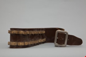
ammunition belt.
https://search.heritageburnaby.ca/link/museumartifact82369
- Repository
- Burnaby Village Museum
- Accession Code
- BV012.14.96
- Description
- brown leather belt, holds 20 bullets, metal buckle, measures 7.3 cm h. x 104 cm. l. x 4 mm. w.
- Object History
- Used by John Yanko for hunting. Hunting for deer and moose was a regular way of stocking a freezer in the garage with game for use by the family. Annie D. Basiuk (later Yanko) was born on February 25, 1902 in Sheho, Saskatchewan (formerly Sheho, North West Territories). Daniel "Dan" Yanko was born in Kobilnicha, Ukraine in 1887 and immigrated to Canada in May or June of 1905. Daniel Yanko married Annie D. Basiuk and had thirteen children together. Their son, John Ivan Yanko was born on the family farm, near Kelliher, Saskatchewan, on June 27, 1923. In grade six, John was pulled out of school to help support the family. Eugenia “Jenny” Haresomovych (later Carman) was born August 8, 1904 in Galecia, Austria. She came to Canada in 1928, when her parents sent her to live with the Austrian consular in Halifax. A year later, she was in The Pas with Albert Edward Carman, with whom she would have three children. Their daughter, Leida Doria "Lillian Doris" Carman was born in The Pas, Manitoba March 24, 1929. Eugenia “Jenny” (Haresomovych) Carman later re-married Joseph Nagy who was born in Hungary in October 3, 1900. Jenny, Joseph and the children moved to Nelson, British Columbia, where Joseph worked for the Canadian Pacific Railway. At the age of twenty, John Yanko met his future wife Lillian Doris Carman while visiting relatives in Burnaby. Lillian received a rail pass because of her dad’s employment with the CPR and at fourteen had gone to visit her Godmother in Burnaby. John Ivan Yanko and Leida Doria "Lillian Doris" Carman were married October 16, 1948 in Nelson, British Columbia and moved into the basement of John’s sister’s house on Union Street. Lillian began working at the downtown Woodward’s store as a cashier in 1948. In 1950, the young couple bought property at 7385 (later renumbered 7391) Broadway in Burnaby and began constructing a house as they could afford it. Knowing she’d be let go if she was pregnant, when Lillian was expecting her first child, Jenny sewed her several versions of the same outfit; they all used the same material, but each was a little bit larger than the last to accommodate her expanding girth. Rhonda, born in 1953 and Charmaine, born in 1955, grew up in the Broadway home. They attended school at Sperling Elementary, and later at Burnaby North high school. Lillian left her job to be a stay-at-home mom when Rhonda was born, but that changed in 1963 when John and Charmaine were in a car accident that left John temporarily unable to work. Joseph Nagy died April 20, 1962; his wife Eugenia “Jenny” (Haresomovych) (Carman) Nagy passed away August 14, 1985. Daniel "Dan" Yanko died in 1976; his wife Annie D. (Basiuk) Yanko died in 1997. John Yanko later returned to work, establishing his own tile setting business and working until age eighty-two. John and Lillian lived out the rest of their married lives on the Broadway property. John Ivan Yanko passed away in 2010; his wife Leida Doria "Lillian Doris" Carman (Carman) Yanko passed away in 2011.
- Names
- Yanko, John Ivan
- Yanko Family
Images

Application for licence for a Gasoline Service Station by Dueck on Broadway Limited
https://search.heritageburnaby.ca/link/councilreport42146
- Repository
- City of Burnaby Archives
- Report ID
- 38316
- Meeting Date
- 9-Jun-1958
- Format
- Council - Manager's Report
- Manager's Report No.
- 11
- Item No.
- 1
- Collection/Fonds
- City Council and Office of the City Clerk fonds
- Repository
- City of Burnaby Archives
- Report ID
- 38316
- Meeting Date
- 9-Jun-1958
- Format
- Council - Manager's Report
- Manager's Report No.
- 11
- Item No.
- 1
- Collection/Fonds
- City Council and Office of the City Clerk fonds
Documents
Application for Permission to Erect and Operate a Roller Rink and Coffee Bar on Lot 4, SD A, Block 7, DL 125 (Southwest Corner of Lougheed and Broadway)
https://search.heritageburnaby.ca/link/councilreport48428
- Repository
- City of Burnaby Archives
- Report ID
- 48558
- Meeting Date
- 4-Oct-1948
- Format
- Council - Mayor/Councillor/Staff Report
- Collection/Fonds
- City Council and Office of the City Clerk fonds
- Repository
- City of Burnaby Archives
- Report ID
- 48558
- Meeting Date
- 4-Oct-1948
- Format
- Council - Mayor/Councillor/Staff Report
- Collection/Fonds
- City Council and Office of the City Clerk fonds
Documents
Application for Purchase Portions of DL 100, DL 101, DL 102, DL 147 - All Adjacent North Road between Broadway East and Pandora Streets
https://search.heritageburnaby.ca/link/councilreport44773
- Repository
- City of Burnaby Archives
- Report ID
- 44343
- Meeting Date
- 24-May-1955
- Format
- Council - Mayor/Councillor/Staff Report
- Collection/Fonds
- City Council and Office of the City Clerk fonds
- Repository
- City of Burnaby Archives
- Report ID
- 44343
- Meeting Date
- 24-May-1955
- Format
- Council - Mayor/Councillor/Staff Report
- Collection/Fonds
- City Council and Office of the City Clerk fonds
Documents
Application for Rezoning the Following: Land Bounded on the North by Broadway, Bounded on the West by Lozells, Bounded on the South by Lougheed between Lozells and Insley, and Bounded on the East by Insley
https://search.heritageburnaby.ca/link/councilreport46217
- Repository
- City of Burnaby Archives
- Report ID
- 45816
- Meeting Date
- 15-Jun-1953
- Format
- Council - Committee Report
- Collection/Fonds
- City Council and Office of the City Clerk fonds
- Repository
- City of Burnaby Archives
- Report ID
- 45816
- Meeting Date
- 15-Jun-1953
- Format
- Council - Committee Report
- Collection/Fonds
- City Council and Office of the City Clerk fonds
Documents
Application of Provincial Department of Highways for Permission to Remove Gravel from the Pit North of Broadway, West of North Road in Conjunction with the Reconstruction of Barnet Highway
https://search.heritageburnaby.ca/link/councilreport43917
- Repository
- City of Burnaby Archives
- Report ID
- 43419
- Meeting Date
- 4-Jun-1956
- Format
- Council - Mayor/Councillor/Staff Report
- Collection/Fonds
- City Council and Office of the City Clerk fonds
- Repository
- City of Burnaby Archives
- Report ID
- 43419
- Meeting Date
- 4-Jun-1956
- Format
- Council - Mayor/Councillor/Staff Report
- Collection/Fonds
- City Council and Office of the City Clerk fonds
Documents
Application to Keep Poultry at 6970 East Broadway
https://search.heritageburnaby.ca/link/councilreport46631
- Repository
- City of Burnaby Archives
- Report ID
- 46391
- Meeting Date
- 25-Aug-1952
- Format
- Council - Mayor/Councillor/Staff Report
- Collection/Fonds
- City Council and Office of the City Clerk fonds
- Repository
- City of Burnaby Archives
- Report ID
- 46391
- Meeting Date
- 25-Aug-1952
- Format
- Council - Mayor/Councillor/Staff Report
- Collection/Fonds
- City Council and Office of the City Clerk fonds
Documents
Application to Keep Poultry at 7145 Broadway
https://search.heritageburnaby.ca/link/councilreport48489
- Repository
- City of Burnaby Archives
- Report ID
- 48497
- Meeting Date
- 13-Sep-1948
- Format
- Council - Mayor/Councillor/Staff Report
- Collection/Fonds
- City Council and Office of the City Clerk fonds
- Repository
- City of Burnaby Archives
- Report ID
- 48497
- Meeting Date
- 13-Sep-1948
- Format
- Council - Mayor/Councillor/Staff Report
- Collection/Fonds
- City Council and Office of the City Clerk fonds