Narrow Results By
Person / Organization
- Bent, Elwood 1
- Brawnlie, Tommy 1
- British Columbia Electric Railway Company 2
- British Columbia Hydro and Power Authority 1
- Brownlee, James Harrison 1
- Burnaby Historical Society 2
- Burnaby Market 1
- Burnaby Village Museum 1
- Byrne, Margaret "Maggie" 1
- Byrne, Mary 1
- Chan, Steven 1
- Chinese Market Gardens 2
![Planning Map of Chinese Market Gardens on Marine Drive, [between 1950 and 1959] (date of original), 2017 (date of duplication) thumbnail](/media/hpo/_Data/_BVM_Images/2017/2017_0040_0002_001.jpg?width=280)
Planning Map of Chinese Market Gardens on Marine Drive
https://search.heritageburnaby.ca/link/museumdescription4297
- Repository
- Burnaby Village Museum
- Date
- [between 1950 and 1959] (date of original), 2017 (date of duplication)
- Collection/Fonds
- Herbert Yee Law family fonds
- Description Level
- Item
- Physical Description
- 1 photograph (tiff) : col. ; 300 dpi
- Scope and Content
- Scanned copy of a survey plan of district lots 163, 162, 157, 158, and 165, near the Chinese Market Gardens along Marine Drive.
- Repository
- Burnaby Village Museum
- Collection/Fonds
- Herbert Yee Law family fonds
- Description Level
- Item
- Physical Description
- 1 photograph (tiff) : col. ; 300 dpi
- Scope and Content
- Scanned copy of a survey plan of district lots 163, 162, 157, 158, and 165, near the Chinese Market Gardens along Marine Drive.
- History
- Survey plan of district lots 163, 162, 157, 158, and 165, which is primarily the area farmed by Chinese and Chinese-Canadian market gardeners around Marine Drive between Royal Oak and Mandeville (present-day Nelson). Two Chinese/Chinese Canadian land owners can be seen on the map: N.G. Wah Sing (or Ng Wah Sing) and Yee Law (or Herbert Law).
- Geographic Access
- Marine Drive
- Accession Code
- BV017.40.2
- Access Restriction
- No restrictions
- Reproduction Restriction
- No known restrictions
- Date
- [between 1950 and 1959] (date of original), 2017 (date of duplication)
- Media Type
- Cartographic Material
- Historic Neighbourhood
- Fraser Arm (Historic Neighbourhood)
- Planning Study Area
- Big Bend Area
- Scan Resolution
- 300
- Scan Date
- 11/19/2017
- Scale
- 100
- Notes
- Title based on contents of copy scan of map
- Herbert Yee Law was donor's father and this map may have originally been his copy of the city planning/engineering documents.
Images
![Planning Map of Chinese Market Gardens on Marine Drive, [between 1950 and 1959] (date of original), 2017 (date of duplication) thumbnail](/media/hpo/_Data/_BVM_Images/2017/2017_0040_0002_001.jpg)
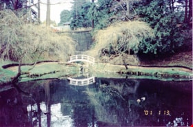
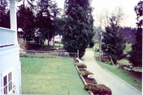
Pond and bridge at New Haven
https://search.heritageburnaby.ca/link/museumdescription13531
- Repository
- Burnaby Village Museum
- Date
- Jan. 2001
- Collection/Fonds
- Burnaby Village Museum Photograph collection
- Description Level
- Item
- Physical Description
- 1 photograph : col. ; 5.3 x 10 cm
- Scope and Content
- Photograph of pond and bridge at New Haven Correctional Centre located on Marine Drive in Burnaby.
- Repository
- Burnaby Village Museum
- Collection/Fonds
- Burnaby Village Museum Photograph collection
- Description Level
- Item
- Physical Description
- 1 photograph : col. ; 5.3 x 10 cm
- Scope and Content
- Photograph of pond and bridge at New Haven Correctional Centre located on Marine Drive in Burnaby.
- History
- In 1937 New Haven Correctional Centre was established as the British Columbia Training School on the southeast side of Marine Drive in Burnaby (4250 Marine Drive). Sections of Sussex and Patterson Avenues bordered the estate. Originally, the facility housed nineteen inmates with two staff and was one of the first initiatives in Canada to segregate young adult inmates into a separate institution apart from adults. This was part of the Borstal system that started in England whereby young male offenders between the ages of sixteen and twenty one were trained to earn an honest living. Alterations and additions to the estate took place between December 1937 and October 1939 so that more inmates could be accomodated. Five new cottages were built that could hold up to forty people. Except for the plastering and lighting, all work on the new cottages was done by the inmates. On October 29, 1939, the Lieutenant-Governor Eric Hamber formally opened the New Haven Borstal School. World War II interrupted full development of the intstitution and it was closed in 1941 when the inmates were were conscripted into the army. Between 1941 and 1947 the Deaf and Blind Institute were housed at New Haven. In 1947, the New Haven Borstal School returned to the estate. New additions were added to old buildings and new additional buildings were erected on the site over the years including a warden's house on the east grounds and a barn and gymnasium. In the 1970s an equipment shed was added along with another dormitory and a variety of small sheds and storage buildings. The correctional centre officially closed in March 2001.
- Subjects
- Public Services - Correctional
- Geographic Access
- Marine Drive
- Street Address
- 4250 Marine Drive
- Accession Code
- BV020.5.875
- Access Restriction
- No restrictions
- Reproduction Restriction
- No known restrictions
- Date
- Jan. 2001
- Media Type
- Photograph
- Historic Neighbourhood
- Fraser Arm (Historic Neighbourhood)
- Planning Study Area
- Suncrest Area
- Scan Resolution
- 600
- Scan Date
- 25-Aug-2020
- Scale
- 100
- Notes
- Title based on contents of photograph
- Photograph processing stamp on front of photograph reads: "'01_1_13"
- Historical information based on notes from Mary Forsyth's research notes "New Haven" MSS185-018
Images

![Portrait of Gay Tim Hong, [1921 or 1922] (date of original), copied 2017 thumbnail](/media/hpo/_Data/_BVM_Images/2017/2017_0036_0002_001.jpg?width=280)
Portrait of Gay Tim Hong
https://search.heritageburnaby.ca/link/museumdescription4251
- Repository
- Burnaby Village Museum
- Date
- [1921 or 1922] (date of original), copied 2017
- Collection/Fonds
- Burnaby Village Museum Photograph collection
- Description Level
- Item
- Physical Description
- 1 photograph (tiff) : 600 dpi
- Scope and Content
- Photograph of Gay Tim Hong wearing a suit and tie.
- Repository
- Burnaby Village Museum
- Collection/Fonds
- Burnaby Village Museum Photograph collection
- Description Level
- Item
- Physical Description
- 1 photograph (tiff) : 600 dpi
- Scope and Content
- Photograph of Gay Tim Hong wearing a suit and tie.
- History
- Josephine Hong was born to Sui Ha Hong and Chan Kow Hong. The Hong Family had seven children, oldest to youngest: Pauline, Josephine, Catherine, Norine, Gary, Darlene, and Marlene. The family runs Hop-On Farm on Marine Drive in Burnaby. Many Hong family members worked on the farm including Josephine Hong's grandfather, Gay Tim Hong, and uncles. Her great-grandfather was Sui Wing Hong
- Subjects
- Persons - Chinese Canadians
- Names
- Hop On Farms
- Hong, Gay Tim
- Accession Code
- BV017.36.2
- Access Restriction
- No restrictions
- Reproduction Restriction
- No known restrictions
- Date
- [1921 or 1922] (date of original), copied 2017
- Media Type
- Photograph
- Historic Neighbourhood
- Fraser Arm (Historic Neighbourhood)
- Related Material
- See Oral History Interview-BV020.6.1
- Scan Resolution
- 600
- Scan Date
- 12/3/2017
- Scale
- 100
- Notes
- Title based on contents of photograph.
- Copy scan is a photograph of a photograph. Date marking evident in corner left edge of photograph. Copy scan generated in 1994.
Images
![Portrait of Gay Tim Hong, [1921 or 1922] (date of original), copied 2017 thumbnail](/media/hpo/_Data/_BVM_Images/2017/2017_0036_0002_001.jpg)
![Portrait of Sui Wing Hong, [1900] (date of original), copied 2017 thumbnail](/media/hpo/_Data/_BVM_Images/2017/2017_0036_0001_001.jpg?width=280)
Portrait of Sui Wing Hong
https://search.heritageburnaby.ca/link/museumdescription4250
- Repository
- Burnaby Village Museum
- Date
- [1900] (date of original), copied 2017
- Collection/Fonds
- Burnaby Village Museum Photograph collection
- Description Level
- Item
- Physical Description
- 1 photograph (tiff) : 600 dpi
- Scope and Content
- Photograph of Sui Wing Hong wearing a hat. Geometric design in background.
- Repository
- Burnaby Village Museum
- Collection/Fonds
- Burnaby Village Museum Photograph collection
- Description Level
- Item
- Physical Description
- 1 photograph (tiff) : 600 dpi
- Scope and Content
- Photograph of Sui Wing Hong wearing a hat. Geometric design in background.
- History
- Josephine Hong was born to Sui Ha Hong and Chan Kow Hong. The Hong Family had seven children, oldest to youngest: Pauline, Josephine, Catherine, Norine, Gary, Darlene, and Marlene. The family runs Hop-On Farm on Marine Drive in Burnaby. Many Hong family members worked on the farm including Josephine Hong's grandfather, Gay Tim Hong, and uncles. Her great-grandfather was Sui Wing Hong
- Subjects
- Persons - Chinese Canadians
- Names
- Hop On Farms
- Hong, Sui Wing
- Accession Code
- BV017.36.1
- Access Restriction
- No restrictions
- Reproduction Restriction
- No known restrictions
- Date
- [1900] (date of original), copied 2017
- Media Type
- Photograph
- Historic Neighbourhood
- Fraser Arm (Historic Neighbourhood)
- Related Material
- See Oral History Interview-BV020.6.1
- Scan Resolution
- 600
- Scan Date
- 12/3/2017
- Scale
- 100
- Notes
- Title based on contents of photograph.
Images
![Portrait of Sui Wing Hong, [1900] (date of original), copied 2017 thumbnail](/media/hpo/_Data/_BVM_Images/2017/2017_0036_0001_001.jpg)
Prisons & Reformatories in Early Burnaby
https://search.heritageburnaby.ca/link/museumdescription14759
- Repository
- Burnaby Village Museum
- Date
- 15 Oct. 2020
- Collection/Fonds
- Burnaby Village Museum fonds
- Description Level
- Item
- Physical Description
- 1 video recording (mp4) (60 min., 53 sec.) : digital, col., sd., stereo ; 29 fps
- Scope and Content
- Item consists of a video recording of a live Zoom webinar hosted by Burnaby Village Museum's Kate Petrusa. The webinar is titled "Prisons & Reformatories in Early Burnaby" and is presented by Lisa Codd, Heritage Planner for the City of Burnaby. The zoom webinar is the fourth in a collection of seve…
- Repository
- Burnaby Village Museum
- Collection/Fonds
- Burnaby Village Museum fonds
- Description Level
- Item
- Physical Description
- 1 video recording (mp4) (60 min., 53 sec.) : digital, col., sd., stereo ; 29 fps
- Material Details
- Presenter: Lisa Codd
- Host: Kate Petrusa
- Date of Presentation: October 15, 6:00 pm - 8:00 pm
- Total Number of tracks: 1
- Total Length of all tracks:60 min., 53 sec
- Recording Device: Zoom video communication platform
- Scope and Content
- Item consists of a video recording of a live Zoom webinar hosted by Burnaby Village Museum's Kate Petrusa. The webinar is titled "Prisons & Reformatories in Early Burnaby" and is presented by Lisa Codd, Heritage Planner for the City of Burnaby. The zoom webinar is the fourth in a collection of seven "Burnaby Neighbourhood Speaker series" webinars that were presented and made available to the public between September 29 and October 27, 2020. The live webinar and recording was also made available on the Burnaby Village Museum's facebook page. In this webinar, Lisa Codd talks about how in the early 20th century Burnaby was home to several correctional and detention institutions that sought to reform their residents, including the Oakalla Prison Farm, New Haven Borstal Home for Boys and Youthful Offenders, the United Church Home for Girls and Home of the Friendless. Lisa supports her presentation with contemporary and historical photographs and research. Lisa pauses throughout the presentation to take questions from webinar participants.
- Creator
- Burnaby Village Museum
- Subjects
- Persons - Japanese Canadians
- Indigenous peoples - British Columbia
- Public Services - Correctional
- Names
- Codd, Lisa
- Oakalla Prison Farm
- New Haven Correctional Centre
- Lower Mainland Regional Correctional Centre
- George, Richardson
- George, Eneas
- George, Alex
- George, Joseph
- Peltier, Leonard
- Home of the Friendless
- Responsibility
- Petrusa, Kate
- Geographic Access
- Oakmount Crescent
- Street Address
- 5220 Oakmount Crescent
- 4250 Marine Drive
- Accession Code
- BV020.29.4
- Access Restriction
- No restrictions
- Reproduction Restriction
- No known restrictions
- Date
- 15 Oct. 2020
- Media Type
- Moving Images
- Historic Neighbourhood
- Burnaby Lake (Historic Neighbourhood)
- Fraser Arm (Historic Neighbourhood)
- Planning Study Area
- Oakalla Area
- Suncrest Area
- Notes
- Title based on contents of video recording
- Video recording was edited for publication on Heritage Burnaby. Original mp4 video recording (BV020.29.4.1) is 73 min.
Images
Video
Prisons & Reformatories in Early Burnaby, 15 Oct. 2020
Prisons & Reformatories in Early Burnaby, 15 Oct. 2020
https://search.heritageburnaby.ca/media/hpo/_Data/_BVM_Moving_Images/2020_0029_0004_002.mp4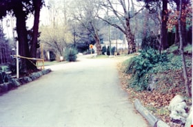
Road and entrance to New Haven
https://search.heritageburnaby.ca/link/museumdescription13526
- Repository
- Burnaby Village Museum
- Date
- Jan. 2001
- Collection/Fonds
- Burnaby Village Museum Photograph collection
- Description Level
- Item
- Physical Description
- 1 photograph : col. ; 5.3 x 10 cm
- Scope and Content
- Photograph of the entrance gate and road to New Haven Correctional Centre on Marine Drive.
- Repository
- Burnaby Village Museum
- Collection/Fonds
- Burnaby Village Museum Photograph collection
- Description Level
- Item
- Physical Description
- 1 photograph : col. ; 5.3 x 10 cm
- Scope and Content
- Photograph of the entrance gate and road to New Haven Correctional Centre on Marine Drive.
- History
- In 1937 New Haven Correctional Centre was established as the British Columbia Training School on the southeast side of Marine Drive in Burnaby (4250 Marine Drive). Sections of Sussex and Patterson Avenues bordered the estate. Originally, the facility housed nineteen inmates with two staff and was one of the first initiatives in Canada to segregate young adult inmates into a separate institution apart from adults. This was part of the Borstal system that started in England whereby young male offenders between the ages of sixteen and twenty one were trained to earn an honest living. Alterations and additions to the estate took place between December 1937 and October 1939 so that more inmates could be accomodated. Five new cottages were built that could hold up to forty people. Except for the plastering and lighting, all work on the new cottages was done by the inmates. On October 29, 1939, the Lieutenant-Governor Eric Hamber formally opened the New Haven Borstal School. World War II interrupted full development of the intstitution and it was closed in 1941 when the inmates were were conscripted into the army. Between 1941 and 1947 the Deaf and Blind Institute were housed at New Haven. In 1947, the New Haven Borstal School returned to the estate. New additions were added to old buildings and new additional buildings were erected on the site over the years including a warden's house on the east grounds and a barn and gymnasium. In the 1970s an equipment shed was added along with another dormitory and a variety of small sheds and storage buildings. The correctional centre officially closed in March 2001.
- Subjects
- Public Services - Correctional
- Geographic Access
- Marine Drive
- Street Address
- 4250 Marine Drive
- Accession Code
- BV020.5.870
- Access Restriction
- No restrictions
- Reproduction Restriction
- No known restrictions
- Date
- Jan. 2001
- Media Type
- Photograph
- Historic Neighbourhood
- Fraser Arm (Historic Neighbourhood)
- Planning Study Area
- Suncrest Area
- Scan Resolution
- 600
- Scan Date
- 25-Aug-2020
- Scale
- 100
- Notes
- Title based on contents of photograph
- Photograph processing stamp on front of photograph reads: "'01_1_13"
- Historical information based on notes from Mary Forsyth's research notes "New Haven" MSS185-018
Images

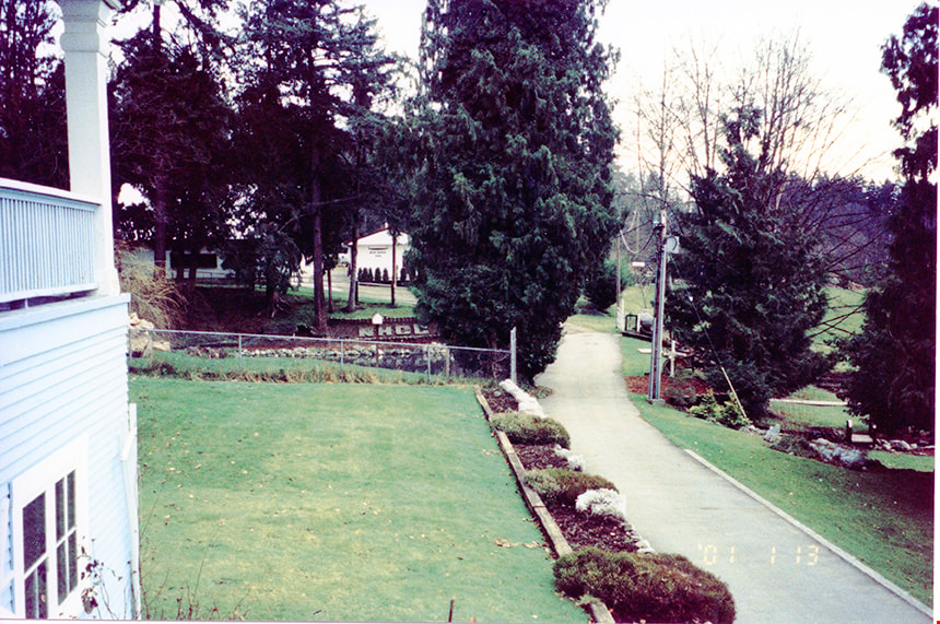
Sidewalk and grounds of New Haven
https://search.heritageburnaby.ca/link/museumdescription13543
- Repository
- Burnaby Village Museum
- Date
- Jan. 2001
- Collection/Fonds
- Burnaby Village Museum Photograph collection
- Description Level
- Item
- Physical Description
- 1 photograph : col. ; 5.3 x 10 cm
- Scope and Content
- Photograph of sidewalk, buildings and grounds of New Haven Correctional Centre. Photograph is taken looking from the main building.
- Repository
- Burnaby Village Museum
- Collection/Fonds
- Burnaby Village Museum Photograph collection
- Description Level
- Item
- Physical Description
- 1 photograph : col. ; 5.3 x 10 cm
- Scope and Content
- Photograph of sidewalk, buildings and grounds of New Haven Correctional Centre. Photograph is taken looking from the main building.
- History
- In 1937 New Haven Correctional Centre was established as the British Columbia Training School on the southeast side of Marine Drive in Burnaby (4250 Marine Drive). Sections of Sussex and Patterson Avenues bordered the estate. Originally, the facility housed nineteen inmates with two staff and was one of the first initiatives in Canada to segregate young adult inmates into a separate institution apart from adults. This was part of the Borstal system that started in England whereby young male offenders between the ages of sixteen and twenty one were trained to earn an honest living. Alterations and additions to the estate took place between December 1937 and October 1939 so that more inmates could be accomodated. Five new cottages were built that could hold up to forty people. Except for the plastering and lighting, all work on the new cottages was done by the inmates. On October 29, 1939, the Lieutenant-Governor Eric Hamber formally opened the New Haven Borstal School. World War II interrupted full development of the intstitution and it was closed in 1941 when the inmates were were conscripted into the army. Between 1941 and 1947 the Deaf and Blind Institute were housed at New Haven. In 1947, the New Haven Borstal School returned to the estate. New additions were added to old buildings and new additional buildings were erected on the site over the years including a warden's house on the east grounds and a barn and gymnasium. In the 1970s an equipment shed was added along with another dormitory and a variety of small sheds and storage buildings. The correctional centre officially closed in March 2001.
- Subjects
- Public Services - Correctional
- Geographic Access
- Marine Drive
- Street Address
- 4250 Marine Drive
- Accession Code
- BV020.5.886
- Access Restriction
- No restrictions
- Reproduction Restriction
- No known restrictions
- Date
- Jan. 2001
- Media Type
- Photograph
- Historic Neighbourhood
- Fraser Arm (Historic Neighbourhood)
- Planning Study Area
- Suncrest Area
- Scan Resolution
- 600
- Scan Date
- 25-Aug-2020
- Scale
- 100
- Notes
- Title based on contents of photograph
- Photograph processing stamp on front of photograph reads: "'01_1_13"
- Historical information based on notes from Mary Forsyth's research notes "New Haven" MSS185-018
Images
![Sui Ha Hong ploughing fields at Hop-On Farm, [between 1975 and 1979] (date of original), copied 2017 thumbnail](/media/hpo/_Data/_BVM_Images/2017/2017_0036_0010_001.jpg?width=280)
Sui Ha Hong ploughing fields at Hop-On Farm
https://search.heritageburnaby.ca/link/museumdescription4259
- Repository
- Burnaby Village Museum
- Date
- [between 1975 and 1979] (date of original), copied 2017
- Collection/Fonds
- Burnaby Village Museum Photograph collection
- Description Level
- Item
- Physical Description
- 1 photograph : colour : copy scan
- Scope and Content
- Photograph of Sui Ha Hong on a red tractor, ploughing fields at Hop-On Farm. Sui Ha is wearing a hat and apron. Farmland and trees evident in background.
- Repository
- Burnaby Village Museum
- Collection/Fonds
- Burnaby Village Museum Photograph collection
- Description Level
- Item
- Physical Description
- 1 photograph : colour : copy scan
- Scope and Content
- Photograph of Sui Ha Hong on a red tractor, ploughing fields at Hop-On Farm. Sui Ha is wearing a hat and apron. Farmland and trees evident in background.
- History
- Josephine Hong was born to Sui Ha Hong and Chan Kow Hong. The Hong Family had seven children, oldest to youngest: Pauline, Josephine, Catherine, Norine, Gary, Darlene, and Marlene. The family runs Hop-On Farm on Marine Drive in Burnaby. Many Hong family members worked on the farm including Josephine Hong's grandfather, Gay Tim Hong, and uncles. Her great-grandfather was Sui Wing Hong
- Subjects
- Persons - Chinese Canadians
- Names
- Hop On Farms
- Hong, Sui Ha
- Geographic Access
- Byrne Road
- Accession Code
- BV017.36.10
- Access Restriction
- No restrictions
- Reproduction Restriction
- May be restricted by third party rights
- Date
- [between 1975 and 1979] (date of original), copied 2017
- Media Type
- Photograph
- Historic Neighbourhood
- Fraser Arm (Historic Neighbourhood)
- Related Material
- See Oral History Interview-BV020.6.1
- Scan Resolution
- 800
- Scan Date
- 12/3/2017
- Scale
- 100
- Notes
- Title based on contents of photograph.
Images
![Sui Ha Hong ploughing fields at Hop-On Farm, [between 1975 and 1979] (date of original), copied 2017 thumbnail](/media/hpo/_Data/_BVM_Images/2017/2017_0036_0010_001.jpg)
![Sui Ha Hong seeding fields at Hop-On Farm, [between 1975 and 1979] (date of original), copied 2017 thumbnail](/media/hpo/_Data/_BVM_Images/2017/2017_0036_0014_001.jpg?width=280)
Sui Ha Hong seeding fields at Hop-On Farm
https://search.heritageburnaby.ca/link/museumdescription4263
- Repository
- Burnaby Village Museum
- Date
- [between 1975 and 1979] (date of original), copied 2017
- Collection/Fonds
- Burnaby Village Museum Photograph collection
- Description Level
- Item
- Physical Description
- 1 photograph : colour : copy scan
- Scope and Content
- Photograph of Sui Ha Hong holding plow, seeding fields at Hop-On Farm. Wooden crates, a building and a man in background. Sui Ha Hong is wearing an apron and farm boots.
- Repository
- Burnaby Village Museum
- Collection/Fonds
- Burnaby Village Museum Photograph collection
- Description Level
- Item
- Physical Description
- 1 photograph : colour : copy scan
- Scope and Content
- Photograph of Sui Ha Hong holding plow, seeding fields at Hop-On Farm. Wooden crates, a building and a man in background. Sui Ha Hong is wearing an apron and farm boots.
- History
- Josephine Hong was born to Sui Ha Hong and Chan Kow Hong. The Hong Family had seven children, oldest to youngest: Pauline, Josephine, Catherine, Norine, Gary, Darlene, and Marlene. The family runs Hop-On Farm on Marine Drive in Burnaby. Many Hong family members worked on the farm including Josephine Hong's grandfather, Gay Tim Hong, and uncles. Her great-grandfather was Sui Wing Hong
- Subjects
- Persons - Chinese Canadians
- Names
- Hop On Farms
- Hong, Sui Ha
- Geographic Access
- Byrne Road
- Accession Code
- BV017.36.14
- Access Restriction
- No restrictions
- Reproduction Restriction
- May be restricted by third party rights
- Date
- [between 1975 and 1979] (date of original), copied 2017
- Media Type
- Photograph
- Historic Neighbourhood
- Fraser Arm (Historic Neighbourhood)
- Related Material
- See Oral History Interview-BV020.6.1
- Scan Resolution
- 800
- Scan Date
- 12/3/2017
- Scale
- 100
- Notes
- Title based on contents of photograph.
Images
![Sui Ha Hong seeding fields at Hop-On Farm, [between 1975 and 1979] (date of original), copied 2017 thumbnail](/media/hpo/_Data/_BVM_Images/2017/2017_0036_0014_001.jpg)
![Survey and Subdivision plans in New Westminster District Group 1 – Burnaby
, [1908] thumbnail](/media/hpo/_Data/_BVM_Cartographic_Material/1977/1977_0093_0004a_001.jpg?width=280)
Survey and Subdivision plans in New Westminster District Group 1 – Burnaby
https://search.heritageburnaby.ca/link/museumdescription6973
- Repository
- Burnaby Village Museum
- Date
- [1908]
- Collection/Fonds
- Burnaby Village Museum Map collection
- Description Level
- File
- Physical Description
- 10 plans : blueprint ink on paper mounted on 2 sides of cardboard ; 76 cm x 102 cm
- Scope and Content
- Item consists of a large board of four New Westminster District Gp 1 - subdivision plans mounted on one side and six New Westminster District Gp 1 - subdivision plans mounted on the other side. Side A: 1. Blueprint "Plan / of - ReSubdivision / of / Lots 1-18 inclusive / Blocks 20 and 21 / in Sub…
- Repository
- Burnaby Village Museum
- Collection/Fonds
- Burnaby Village Museum Map collection
- Description Level
- File
- Physical Description
- 10 plans : blueprint ink on paper mounted on 2 sides of cardboard ; 76 cm x 102 cm
- Material Details
- Scales [between 1:792 and 1:4752]
- Index number on edge of board reads: "4"
- Scope and Content
- Item consists of a large board of four New Westminster District Gp 1 - subdivision plans mounted on one side and six New Westminster District Gp 1 - subdivision plans mounted on the other side. Side A: 1. Blueprint "Plan / of - ReSubdivision / of / Lots 1-18 inclusive / Blocks 20 and 21 / in Subdivision / of / Lot 53 -Gr.1 / New Westminster District" / "Subdivision Lot Numbers - Shown in Red". Plan is bordered by First Street / Jorgenson's Line / Fourth Avenue and Second Street with Fifith Avenue running through the centre. There is an index in the upper right corner of the plan. Planned is signed by "Peter Byrne" and "William R. Phillips" and dated July 28, 1908. (Geographic location: Burnaby) 2. Blueprint "Plan / of Subdivision / of / Lot 159 / and a Portion of Lot 158 / Group One / New Westminster District". Plan is bordered by Lots 96 and 97; South Wilson Street; North Arm Road and Lot 160 / Power House Road (Lot 155 A). B.C.E.R. Gilley Station is identified in the upper right corner of the plan. (Geographic location: Burnaby) 3. Blueprint plan identified as "Subdvs 10, L 88 and Lot 25, G. 1" Plan identifies Cumberland Street running from top to the bottom and a Ravine running alongside with the Jensen house, stable and barn. (Geographic location: Burnaby) 4. Blueprint Plan of "Lot 153. G. 1 /New Westminster District". Plan identifies the "New Westminster & Vancouver Tramway" and the "New Westminster and Vancouver Road" running through the plan of Lot 53. (Geographic location: Burnaby) Side B: 1. Blueprint plan of "Profile on Proposed North Rd. Diversion". 2. Blueprint plan (no title) showing wood lots north of Burnaby Lake and Brunette River and west of North Road. Various lots are identified as "Heavily Timbered" (Lot 57); "Splendid Fir and Cedar / Heavy Fir etc. / Fine Cedar" (Lots 143, 148); "Rough Light Timber," (Lot 56); "Some Fir and Cedar" (Lot 40). (Geographic location: Burnaby) 3. Blueprint "Plan / of Subdivision / of a Portion / of Lot 87, Gr.1 / New Westminster District". Plan is bordered by Burnaby Lake at the top and Hastings Road / Lot 86 at the bottom and Lot 90 to the east. "Albert J. Hill B.C.LotS." Annotation in ink reads: " J.A. Brownlee, B.C.L.S. / Subdivision / Map 1494 / Bd. 248". Plan is signed by "Peter Byrne, Reeve" (Geographic location: Burnaby) 4. Blueprint plan of Subdivisions along either side of Douglas Road including Lots 117; 119; 74; 80; 79 and 77. (Geographic location: Burnaby) 5. Blueprint "Plan / of / Subdivision of / Lot 27 / in Subdivision / of / Lot 30 / Group One / New Westminster District" Plan is bordered by Lot 26, Lot 28 and Hastings Rd. Lot 27 runs north of Edmonds Street. , "Albert J. Hill, B.C.LotS." (Geographic location: Burnaby) 6. Blueprint plan identified as a "Cultivated Orchard" including the names "W. Grace" and "G. Mead" located north of the North Arm Fraser River and west of "Twentieth Street_ City Boundary". Handwritten annotation in coloured pencil reads: "Portion of Lot 172" (Geographic location: Burnaby)
- Subjects
- Geographic Features - Forests
- Geographic Access
- Cumberland Street
- North Road
- Hastings Street
- Douglas Road
- Accession Code
- HV977.93.4
- Access Restriction
- No restrictions
- Reproduction Restriction
- No known restrictions
- Date
- [1908]
- Media Type
- Cartographic Material
- Historic Neighbourhood
- Burnaby Lake (Historic Neighbourhood)
- Fraser Arm (Historic Neighbourhood)
- Planning Study Area
- Douglas-Gilpin Area
- Burnaby Lake Area
- Scan Resolution
- 300
- Scale
- 72
- Notes
- Title based on contents of file
- Scale is measured in chains. (One chain equals 792 inches)
- The term "Lot" can also refer to a "District Lot”-
Images
![Survey and Subdivision plans in New Westminster District Group 1 – Burnaby
, [1908] thumbnail](/media/hpo/_Data/_BVM_Cartographic_Material/1977/1977_0093_0004a_001.jpg)

![Survey and Subdivision plans in New Westminster District Group 1 – Burnaby, [1905-1909] thumbnail](/media/hpo/_Data/_BVM_Cartographic_Material/1977/1977_0093_0024a_001.jpg?width=280)
Survey and Subdivision plans in New Westminster District Group 1 – Burnaby
https://search.heritageburnaby.ca/link/museumdescription6993
- Repository
- Burnaby Village Museum
- Date
- [1905-1909]
- Collection/Fonds
- Burnaby Village Museum Map collection
- Description Level
- File
- Physical Description
- 11 plans : 8 plans : black ink on paper + 2 plans : graphite on paper + 1 plan : graphite and ink on paper mounted on 2 sides of cardboard 76 x 102 cm
- Scope and Content
- Item consists of a large board of seven New Westminster District subdivision plans mounted on one side and four New Westminster District subdivision plans mounted on the other side. Side A: 1. Small subdivision plan of "Lot 2, Gr.1" drawn in black ink with annotation "Now Lot 1 of Subd of Lot 2 /…
- Repository
- Burnaby Village Museum
- Collection/Fonds
- Burnaby Village Museum Map collection
- Description Level
- File
- Physical Description
- 11 plans : 8 plans : black ink on paper + 2 plans : graphite on paper + 1 plan : graphite and ink on paper mounted on 2 sides of cardboard 76 x 102 cm
- Material Details
- Scales [between 1:1200 and 1:3600]
- Index number on edge of board reads: "24"
- Scope and Content
- Item consists of a large board of seven New Westminster District subdivision plans mounted on one side and four New Westminster District subdivision plans mounted on the other side. Side A: 1. Small subdivision plan of "Lot 2, Gr.1" drawn in black ink with annotation "Now Lot 1 of Subd of Lot 2 / see Bd. 5". Plan is initialed by: "RB" [sic] (in blue pencil crayon) with "Scale 3 ch = 1 in" and signed by "Albert J. Hill / P.L.S." (in graphite). (Geographic location: Burnaby) 2. Plan of "Lot 43, G.1" north of Burnaby Lake and surrounded by Lot 59, Lot 44, Lot 42. Lot 43 identifies physical features including: " roads / beaver dam / cranberry bog / roads / large brook / cutting / spruce / cedar / vine paper and alder / cedar / light spruce". Lot 59 identifies physical features: "heavy timber / alder and cedar etc" (Geographic location: Burnaby) 3. "Plan / Shewing Subdivision of part of / Lot 156 G.1 / Burnaby / N.W.D. / BC / Scale 300 ft = 1 inch" Annotation at top of plan reads: "#1030_Deposited / in the Land Registry Office / at New Westminster BC / 24th February 1908 / C.S. Keith Dist Reg I / RB". Plan is signed by "Peter Byrne / Reeve" and "H.G. Youdall [sic] _ BCLS" (Geographic location: Burnaby) 4. "Plan / of / Subdivision of Part / Lot 25, Group 1, N.W.D. / Burnaby Municipality / Scale: 3 chains = 1 inch" (drawn in graphite). Plan is initialed by: "RB" [sic] (in blue pencil crayon) and signed by "H.N. Smith" and "1024 / Deposited 25th / Jan. 1908 / Keith" (graphite) (Geographic location: Burnaby) 5. Handrawn plan in graphite is identified as "Lots 89 & 90 Gr.1" and intialed "RB" [sic] (in blue pencil crayon) (Geographic location: Burnaby) 7. Plan of "Lot 95 Gr. 1". Plan includes a portion of District Lot 95 near the intersection of centre line of B.C.E.R. and B.C.E.Ry - Vancouver Road. Plan is stamped: "Albert J. Hill, Civil Engineer / and / Provincial Land Surveyor, / New Westminster, / B.C." and initialed by "RB" [sic] (in blue pencil crayon) (Geographic location: Burnaby) 6. "Plan of Subdivision / of Sub Lot XI, Block 11 / DL 25, Gr.1 / (Burnaby) / N.W.D. / Scale 100 feet = 1 inch". Plan is dated "May 13, 1909" and signed by "W.R. Williams / Owner _ H.M. Smith" . Plan is initialed by: "RB" [sic] (in blue pencil crayon) (Geographic location: Burnaby) Side B: 1. "Plan / of Subdivision / of / Block "F" / in the Subdivision / of / Lot 29, Group 1. / New Westminster District / Scale 2chs = 1in" . Plan is stamped: "Albert J. Hill, Civil Engineer / and / Provincial Land Surveyor, / New Westminster, / B.C.". Plan is initialed by: "RB" [sic] (in blue pencil crayon) (Geographic location: Burnaby) 2. Plan of "Portion Lot B Gr.1". Plan includes annotations in graphite reading: "See Board 52-8 & 56-53" / "Sketch / see orig. plan". Plan is stamped: "Albert J. Hill, Civil Engineer / and / Provincial Land Surveyor, / New Westminster, / B.C." and is initialed by: "RB" [sic] (in blue pencil crayon) 3. Untitled plan drawn in black ink showing the "Brunette River", the "V.W. & Y.RY" and "Gunn Road _Diversion" running through Lot 13, Lot 2 - H.Gunn, Lot 4 - A.Lewis, Lot 10 - Geo. Love and W. Leonard and Lot 40. Plan is stamped: "Albert J. Hill, Civil Engineer / and / Provincial Land Surveyor, / New Westminster, / B.C." and initialed by "RB" [sic] (in blue pencil crayon) (Geographic location: Burnaby) 4."Plan / of / a Portion of the Foreshore / of / The North Arm of the Fraser River / Fronting / A Portion of Lot 166 Gr.1 / N.W. Dist. B.C. / Scale 100' = 1 " / Soundings taken from Map of D.P.W. Surveys". Plan is initialed by: "RB" [sic] (in blue pencil crayon) and includes annotations in red ink reading: "Office Copy" / "Plotted / Dec. 9th 1908 / G.K.B." (Geographic location: Burnaby)
- Creator
- Hill, Albert James
- Smith, H. Neville
- Accession Code
- HV977.93.24
- Access Restriction
- No restrictions
- Reproduction Restriction
- No known restrictions
- Date
- [1905-1909]
- Media Type
- Cartographic Material
- Historic Neighbourhood
- Burnaby Lake (Historic Neighbourhood)
- Fraser Arm (Historic Neighbourhood)
- Planning Study Area
- Burnaby Lake Area
- Scan Resolution
- 300
- Scale
- 72
- Notes
- Title based on contents of file
- Scale is measured in chains and feet. (One chain equals 792 inches)
- The term "Lot" can also refer to a "District Lot"
Images
![Survey and Subdivision plans in New Westminster District Group 1 – Burnaby, [1905-1909] thumbnail](/media/hpo/_Data/_BVM_Cartographic_Material/1977/1977_0093_0024a_001.jpg)

![Switching engines at BC Hydro, Trap Yard, New Westminster, [1985] thumbnail](/media/hpo/_Data/_BVM_Images/2012/2012_0018_0001_001.jpg?width=280)
Switching engines at BC Hydro, Trap Yard, New Westminster
https://search.heritageburnaby.ca/link/museumdescription2878
- Repository
- Burnaby Village Museum
- Date
- [1985]
- Collection/Fonds
- Burnaby Village Museum Photograph collection
- Description Level
- Item
- Physical Description
- 1 photograph : col. ; 20 x 20 cm
- Scope and Content
- Photograph of BC Hydro, Trap Yard, New Westminster. There appears to be six yellow Hydro switching engines on tracks in front of engine maintanence building.
- Repository
- Burnaby Village Museum
- Collection/Fonds
- Burnaby Village Museum Photograph collection
- Description Level
- Item
- Physical Description
- 1 photograph : col. ; 20 x 20 cm
- Scope and Content
- Photograph of BC Hydro, Trap Yard, New Westminster. There appears to be six yellow Hydro switching engines on tracks in front of engine maintanence building.
- Subjects
- Transportation - Locomotives
- Accession Code
- BV012.18.1
- Access Restriction
- No restrictions
- Reproduction Restriction
- No known restrictions
- Date
- [1985]
- Media Type
- Photograph
- Historic Neighbourhood
- Fraser Arm (Historic Neighbourhood)
- Planning Study Area
- Big Bend Area
- Scan Resolution
- 300
- Scan Date
- 13-Mar-2018
- Photographer
- Carson, Dwight W.
- Notes
- Title based on contents of photograph
Images
![Switching engines at BC Hydro, Trap Yard, New Westminster, [1985] thumbnail](/media/hpo/_Data/_BVM_Images/2012/2012_0018_0001_001.jpg)
![Team of horses at logging site, [1890] thumbnail](/media/hpo/_Data/_BVM_Images/1977/197701400001.jpg?width=280)
Team of horses at logging site
https://search.heritageburnaby.ca/link/museumdescription636
- Repository
- Burnaby Village Museum
- Date
- [1890]
- Collection/Fonds
- Burnaby Village Museum Photograph collection
- Description Level
- Item
- Physical Description
- 1 photograph : sepia ; 27 x 36 cm, mounted on card 27 x 36 cm
- Scope and Content
- Photograph of a team of ten equine animals reined together in pairs at a logging site at Gilley Avenue. The pair in front looks to be a mule and a draft horse while all other pairs appear to be draft horses.
- Repository
- Burnaby Village Museum
- Collection/Fonds
- Burnaby Village Museum Photograph collection
- Description Level
- Item
- Physical Description
- 1 photograph : sepia ; 27 x 36 cm, mounted on card 27 x 36 cm
- Scope and Content
- Photograph of a team of ten equine animals reined together in pairs at a logging site at Gilley Avenue. The pair in front looks to be a mule and a draft horse while all other pairs appear to be draft horses.
- Geographic Access
- Gilley Avenue
- Accession Code
- HV977.140.1
- Access Restriction
- No restrictions
- Date
- [1890]
- Media Type
- Photograph
- Historic Neighbourhood
- Fraser Arm (Historic Neighbourhood)
- Scan Resolution
- 600
- Scan Date
- 1/8/2010
- Scale
- 100
- Notes
- Title based on contents of photograph
Images
![Team of horses at logging site, [1890] thumbnail](/media/hpo/_Data/_BVM_Images/1977/197701400001.jpg)
![Team of oxen, [1888] thumbnail](/media/hpo/_Data/_BVM_Images/1977/197701400003.jpg?width=280)
Team of oxen
https://search.heritageburnaby.ca/link/museumdescription638
- Repository
- Burnaby Village Museum
- Date
- [1888]
- Collection/Fonds
- Burnaby Village Museum Photograph collection
- Description Level
- Item
- Physical Description
- 1 photograph : sepia ; 19 x 23cm, mounted on card 30 x 35 cm
- Scope and Content
- Photograph of a team of four oxen and their handler working near Kingsway on Gilley Avenue. A second lumberjack is resting on a log as the team moves past.
- Repository
- Burnaby Village Museum
- Collection/Fonds
- Burnaby Village Museum Photograph collection
- Description Level
- Item
- Physical Description
- 1 photograph : sepia ; 19 x 23cm, mounted on card 30 x 35 cm
- Scope and Content
- Photograph of a team of four oxen and their handler working near Kingsway on Gilley Avenue. A second lumberjack is resting on a log as the team moves past.
- Geographic Access
- Gilley Avenue
- Accession Code
- HV977.140.3
- Access Restriction
- No restrictions
- Date
- [1888]
- Media Type
- Photograph
- Historic Neighbourhood
- Fraser Arm (Historic Neighbourhood)
- Scan Resolution
- 600
- Scan Date
- 1/15/2010
- Scale
- 100
- Notes
- Title based on contents of photograph
- Note in pencil on verso of photograph reads: "Near Kingsway on Gilley Ave. about 1888"
Images
![Team of oxen, [1888] thumbnail](/media/hpo/_Data/_BVM_Images/1977/197701400003.jpg)

Where is your food from?
https://search.heritageburnaby.ca/link/museumdescription14270
- Repository
- Burnaby Village Museum
- Date
- 2020
- Collection/Fonds
- Burnaby Village Museum fonds
- Description Level
- Item
- Physical Description
- 1 sound recording (mp3) (00:17:10 min)
- Scope and Content
- Item consists of a recording of part two in a series of three “Back to the Roots” podcasts about the history of Chinese-Canadian farming in Burnaby and the lower mainland. Part two is titled “Where is your food from?" The podcasts were created by students Rose Wu and Wei Yan Yeong from the Faculty …
- Repository
- Burnaby Village Museum
- Collection/Fonds
- Burnaby Village Museum fonds
- Series
- UBC Partnership series
- Description Level
- Item
- Physical Description
- 1 sound recording (mp3) (00:17:10 min)
- Material Details
- Podcasts hosts: Rose Wu; Wei Yan Yeong Guest: Denise Fong Music: prod. riddiman Podcast Date: October 2020 Total Number of tracks: 1 Total Length of all tracks: 00:17:10 min Photograph info: Store front of Way Sang Yuen Wat Kee & Co in Victoria, B.C., 1975. BV017.7.191
- Scope and Content
- Item consists of a recording of part two in a series of three “Back to the Roots” podcasts about the history of Chinese-Canadian farming in Burnaby and the lower mainland. Part two is titled “Where is your food from?" The podcasts were created by students Rose Wu and Wei Yan Yeong from the Faculty of Land and Food Systems at the University of British Columbia Faculty and while student interns at Burnaby Village Museum. In this series the students connect their knowledge of food systems to their shared Chinese heritage in order to discover how Chinese Canadian history is rooted in their local food systems. "Where is your food from?" explores contemporary versus historical alternative food movements and how early Chinese farmers in the lower mainland had to be creative in their business tactics in order to survive in a local food system that discriminated against their race. 00:00-02:45 The podcast opens with an audio clip from Harvard University professor and world renowned food journalist and author of "The Ominvore's Dilemma", Michael Pollan. Wei Yan Yeong and Rose Wu introduce themselves and their topic "Where is your food from?" They comment on the global philosophy "Eat local, think global" and question whether this philosphy ignores the struggles faced by local farms operated by immigrant workers back in the day. They comment "Unlike how these alternative food movements are heralded as sustainable, healthy, and even sometimes trendy now in today’s standards, for Chinese farmers, these alternative food movements were necessary for survival against discriminatory practices entrenched in the food system they were servicing." 02:46 - 06:21 This portion provides background on Chinese immigrant farmers and the establishment of "market gardens" or "truck farms". Rose and Wei Yan tell of how up to the 1970s, Chinese farms produced mostly European staples such as potatoes, carrots, tomatoes, corn and cabbage because there was no market for Chinese crops. Many of the Chinese immigrants were forced into farming and other menial jobs due to discriminatory practices that excluded them from other types of employment. The hosts provide a synopsis of Burnaby Bylaw Number 4, created in 1892, "The Chinese and Japanese Exclusion Bylaw" which prohibited any Chinese or Japanese person from working for the Municipality of Burnaby. Burnaby Village Museum researcher Denise Fong provides information on Chinese immigrants in Burnaby, how many of them were farmers in the Big Bend area and how hard it was for them to own land due to racial discrimination. Denise also refers to an article in"Harrowsmith" magazine (c.1980s) where thirty five Chinese-Canadians operated farms in Burnaby. 06:22 - 09:24 This portion provides a description of Chinese market farms and vegetable peddling. Background information about the history of market farms, truck farms and vegetable peddling in Burnaby and the lower mainland provided by Denise Fong. 09:24 - 12:03 This portion talks about the policies put in place to create further barriers to Chinese farmers. Denise Fong provides information regarding the civic bylaws that were created to restrict produce sales, fines and fees that were imposed on peddlers, establishment of green grocers, the Chinese Marketing Act, the establishment of organizations to support Chinese farmers including the Chinese Growers Assocation. 12:04 - 15:00 This portion talks about how Chinese-Canadians played important roles in conventional "long" food networks. Denise Fong provides information in how Chinese Canadians participated in the larger food distribution network in British Columbia. Denise shares a story of Chinese-Canadian Cecil Lee and how he introduced the import of Chinese mandarin oranges into British Columbia. 15:01 - 16:29 Final summary regarding the contraditions in our local food system that continue to persist today and how despite the improved status of Chinese-Canadians in British Columbia, cheap, migrant labourers continue to be an overlooked part of our local food system. This portion includes a recorded excerpt from M.L.A. Mabel Elmore regarding Temporary Foreign Workers (presented before the NDP caucous in 2015). 16:29 - 17:22 Credits, thanks and acknowledgements. Special thanks to Duncan McCue and M.LA. Mabel Elmore. Music created by P. Ruderman
- History
- Podcast hosts, Rose Wu and Wei Yan Yeong are University of British Columbia students in the Faculty of Land and Food Systems and student interns at Burnaby Village Museum. Guest, Denise Fong is a historical researcher at Burnaby Village Museum. She has degrees in Anthropology (BA) and Archaeology (MA), and is completing her doctoral degree at UBC in Interdisciplinary Studies. Her primary research interests are in Chinese Canadian history and critical heritage studies. She is the co-curator of the Burnaby Village Museum “Across the Pacific” exhibition, and the Museum of Vancouver’s “A Seat at the Table – Chinese Immigration and British Columbia”.
- Creator
- Burnaby Village Museum
- Subjects
- Persons - Chinese Canadians
- Agriculture - Farms
- Agriculture
- Gardens - Market Gardens
- Social Issues - Discrimination
- Social Issues - Racism
- Responsibility
- Yeong, Wei Yan
- Wu, Rose
- Geographic Access
- Marine Drive
- Accession Code
- BV020.28.4
- Access Restriction
- No restrictions
- Reproduction Restriction
- No known restrictions
- Date
- 2020
- Media Type
- Sound Recording
- Historic Neighbourhood
- Fraser Arm (Historic Neighbourhood)
- Planning Study Area
- Big Bend Area
- Related Material
- BV020.28.3; BV020.28.5
- Notes
- Title based contents of sound recording
- For associated video recording of research interview with Denise Fong - see BV020.28.2
- Compilation of Research Resources used by authors Rose Wu and Wei Yan Yeong include:
- Lim, S. (2015). Feeding the "Greenest City": Historicizing "Local," Labour, and the Postcolonial Politics of Eating. Canadian Journal of Urban Research, 24(1), 78-100. Retrieved October 22, 2020, from http://www.jstor.org/stable/26195279
- Mable Elmore’s statement on the plight of temporary foreign workers https://www.youtube.com/watch?v=LF4_js0R-Mo&ab_channel=BCNDPCaucus
- Michael Pollen’s speech at UBC Farm https://www.youtube.com/watch?v=o1n-kRJhPPQ&feature=emb_title&ab_channel=LFSLearningCentre
- Gibb, Natalie & Wittman, Hannah. (2012). Parallel alternatives: Chinese-Canadian farmers and the Metro Vancouver local food movement. Local Environment. 18. 1-19. 10.1080/13549839.2012.714763.
- Yu, J. (2014, March 31). The integration of the Chinese market gardens of southern British Columbia, 1885-1930 [R]. doi:http://dx.doi.org/10.14288/1.0228676
- Burnaby Village Museum, Interview with Denise Fong by Rose Wu and Wei Yan Yeong, 2020. BV020.28.2 https://search.heritageburnaby.ca/permalink/museumvideo14276
Images

Audio Tracks
Where is your food from?, 2020
Where is your food from?, 2020
https://search.heritageburnaby.ca/media/hpo/_Data/_BVM_Sound_Recordings/Sound_Recordings/2020_0028_0004_001.mp3Windows to Burnaby's past : a preliminary survey of Burnaby's pre-1930 buildings
https://search.heritageburnaby.ca/link/museumlibrary998
- Repository
- Burnaby Village Museum
- Author
- Watson, Ann
- Publication Date
- 1985
- Call Number
- 720.971 BUR Ver. 1
- Repository
- Burnaby Village Museum
- Collection
- Reference Collection
- Material Type
- Textual Record
- Call Number
- 720.971 BUR Ver. 1
- Author
- Watson, Ann
- Contributor
- Wolf, Jim
- Publisher
- Burnaby Historical Society
- Publication Date
- 1985
- Physical Description
- [540] p. : ill. ; 30 cm.
- Library Subject (LOC)
- Historic buildings--British Columbia--Burnaby
- Burnaby (B.C.)--Buildings, structures, etc.
- Burnaby (B.C.)--History
- Historic Neighbourhood
- Capitol Hill (Historic Neighbourhood)
- Alta-Vista (Historic Neighbourhood)
- Vancouver Heights (Historic Neighbourhood)
- Lochdale (Historic Neighbourhood)
- Barnet (Historic Neighbourhood)
- Broadview (Historic Neighbourhood)
- Burnaby Lake (Historic Neighbourhood)
- Burquitlam (Historic Neighbourhood)
- Central Park (Historic Neighbourhood)
- Edmonds (Historic Neighbourhood)
- East Burnaby (Historic Neighbourhood)
- Fraser Arm (Historic Neighbourhood)
- Notes
- "A report of the Burnaby Historical Society." -- Subtitle page
- "Prepared by Ann Watson, assisted by Jim Wolf, for the Burnaby Historical Society, May 13 to August 13th, 1985." -- Title page
- Includes blibliography
- Cross-reference with 720.971 BUR Ver. 2
Windows to Burnaby's past : a preliminary survey of Burnaby's pre-1930 buildings
https://search.heritageburnaby.ca/link/museumlibrary6686
- Repository
- Burnaby Village Museum
- Author
- Watson, Ann
- Publication Date
- 1985
- Call Number
- 720.971 BUR Ver. 2
- Repository
- Burnaby Village Museum
- Collection
- Reference Collection
- Material Type
- Textual Record
- Call Number
- 720.971 BUR Ver. 2
- Author
- Watson, Ann
- Contributor
- Wolf, Jim
- Publisher
- Burnaby Historical Society
- Publication Date
- 1985
- Physical Description
- [540] p. : map. ; 30 cm.
- Library Subject (LOC)
- Historic buildings--British Columbia--Burnaby
- Burnaby (B.C.)--Buildings, structures, etc.
- Burnaby (B.C.)--History
- Historic Neighbourhood
- Capitol Hill (Historic Neighbourhood)
- Alta-Vista (Historic Neighbourhood)
- Vancouver Heights (Historic Neighbourhood)
- Lochdale (Historic Neighbourhood)
- Barnet (Historic Neighbourhood)
- Broadview (Historic Neighbourhood)
- Burnaby Lake (Historic Neighbourhood)
- Burquitlam (Historic Neighbourhood)
- Central Park (Historic Neighbourhood)
- Edmonds (Historic Neighbourhood)
- East Burnaby (Historic Neighbourhood)
- Fraser Arm (Historic Neighbourhood)
- Notes
- "Project funded by the British Columbia Heritage Trust." -- Cover
- "Prepared by Ann Watson, assisted by Jim Wolf, for the Burnaby Historical Society, May 13 to August 13th, 1985." -- Cover
- Includes bibliography
- Cross-reference with 720.971 BUR Ver. 1
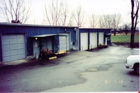
Workshop buildings at New Haven
https://search.heritageburnaby.ca/link/museumdescription13535
- Repository
- Burnaby Village Museum
- Date
- Jan. 2001
- Collection/Fonds
- Burnaby Village Museum Photograph collection
- Description Level
- Item
- Physical Description
- 1 photograph : col. ; 5.3 x 10 cm
- Scope and Content
- Photograph of workshop buildings with five bay doors at New Haven Correctional Centre.
- Repository
- Burnaby Village Museum
- Collection/Fonds
- Burnaby Village Museum Photograph collection
- Description Level
- Item
- Physical Description
- 1 photograph : col. ; 5.3 x 10 cm
- Scope and Content
- Photograph of workshop buildings with five bay doors at New Haven Correctional Centre.
- History
- In 1937 New Haven Correctional Centre was established as the British Columbia Training School on the southeast side of Marine Drive in Burnaby (4250 Marine Drive). Sections of Sussex and Patterson Avenues bordered the estate. Originally, the facility housed nineteen inmates with two staff and was one of the first initiatives in Canada to segregate young adult inmates into a separate institution apart from adults. This was part of the Borstal system that started in England whereby young male offenders between the ages of sixteen and twenty one were trained to earn an honest living. Alterations and additions to the estate took place between December 1937 and October 1939 so that more inmates could be accomodated. Five new cottages were built that could hold up to forty people. Except for the plastering and lighting, all work on the new cottages was done by the inmates. On October 29, 1939, the Lieutenant-Governor Eric Hamber formally opened the New Haven Borstal School. World War II interrupted full development of the intstitution and it was closed in 1941 when the inmates were were conscripted into the army. Between 1941 and 1947 the Deaf and Blind Institute were housed at New Haven. In 1947, the New Haven Borstal School returned to the estate. New additions were added to old buildings and new additional buildings were erected on the site over the years including a warden's house on the east grounds and a barn and gymnasium. In the 1970s an equipment shed was added along with another dormitory and a variety of small sheds and storage buildings. The correctional centre officially closed in March 2001.
- Subjects
- Public Services - Correctional
- Geographic Access
- Marine Drive
- Street Address
- 4250 Marine Drive
- Accession Code
- BV020.5.878
- Access Restriction
- No restrictions
- Reproduction Restriction
- No known restrictions
- Date
- Jan. 2001
- Media Type
- Photograph
- Historic Neighbourhood
- Fraser Arm (Historic Neighbourhood)
- Planning Study Area
- Suncrest Area
- Scan Resolution
- 600
- Scan Date
- 25-Aug-2020
- Scale
- 100
- Notes
- Title based on contents of photograph
- Photograph processing stamp on front of photograph reads: "'01_1_13"
- Historical information based on notes from Mary Forsyth's research notes "New Haven" MSS185-018
Images
