Narrow Results By
Subject
- Accidents 15
- Accidents - Automobile Accidents 30
- Accidents - Train Accidents 23
- Adminstrative Groups - Committees 4
- Adornment - Jewelry 7
- Adornment - Lapel Pins 1
- Advertising Medium 11
- Advertising Medium - Flyer 3
- Advertising Medium - Poster 16
- Advertising Medium - Signs and Signboards 221
- Aerial Photographs 132
- Agricultural Tools and Equipment 24
![Oakalla Prison Farm, [193-] (date of original), copied 1986 thumbnail](/media/hpo/_Data/_Archives_Images/_Unrestricted/126/179-003.jpg?width=280)
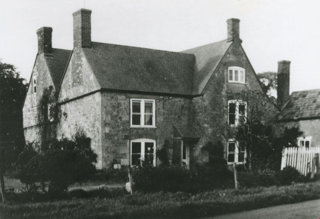
Oakalla Prison Farm
https://search.heritageburnaby.ca/link/archivedescription35032
- Repository
- City of Burnaby Archives
- Date
- [193-] (date of original), copied 1986
- Collection/Fonds
- Burnaby Historical Society fonds
- Description Level
- Item
- Physical Description
- 1 photograph : b&w ; 12.6 x 8.8 cm print
- Scope and Content
- Photograph of pigs outside at Oakalla Prison Farm. Deer Lake can be seen in the background.
- Repository
- City of Burnaby Archives
- Date
- [193-] (date of original), copied 1986
- Collection/Fonds
- Burnaby Historical Society fonds
- Subseries
- Chamberlain family subseries
- Physical Description
- 1 photograph : b&w ; 12.6 x 8.8 cm print
- Description Level
- Item
- Record No.
- 179-003
- Access Restriction
- No restrictions
- Reproduction Restriction
- No known restrictions
- Accession Number
- BHS1986-27
- Scope and Content
- Photograph of pigs outside at Oakalla Prison Farm. Deer Lake can be seen in the background.
- Names
- Oakalla Prison Farm
- Media Type
- Photograph
- Notes
- Title based on contents of photograph
- Geographic Access
- Oakmount Crescent
- Deer Lake
- Street Address
- 5220 Oakmount Crescent
- Historic Neighbourhood
- Burnaby Lake (Historic Neighbourhood)
- Planning Study Area
- Oakalla Area
Images
![Oakalla Prison Farm, [193-] (date of original), copied 1986 thumbnail](/media/hpo/_Data/_Archives_Images/_Unrestricted/126/179-003.jpg)
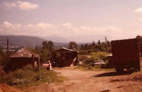
Out building on Lubbock farm
https://search.heritageburnaby.ca/link/museumdescription12809
- Repository
- Burnaby Village Museum
- Date
- 1977
- Collection/Fonds
- Century Park Museum Association fonds
- Description Level
- Item
- Physical Description
- 1 photograph : col. slide ; 35 mm
- Scope and Content
- Photograph of on out building located on the Lubbock farm, 7803 Burris Street.
- Repository
- Burnaby Village Museum
- Collection/Fonds
- Century Park Museum Association fonds
- Description Level
- Item
- Physical Description
- 1 photograph : col. slide ; 35 mm
- Scope and Content
- Photograph of on out building located on the Lubbock farm, 7803 Burris Street.
- History
- In 1977, Century Park Museum was granted access to the Sprott-Lubbock farm to appraise the heritage buildings for preservation. Buildings that were saved included the old farrier shed (BV985.1240.2) which was also used as a blacksmith shop and the Vorce tram station building (BV985.1240.3) from the old Burnaby Lake Interurban line which was used as a grain storage shed on the property. Segments of the original farmhouse and other out buildings were retained. Other buildings on the site were demolished to make way for a new housing development.
- Subjects
- Agriculture - Farms
- Names
- Lubbock farm
- Geographic Access
- Grandview Highway
- Burris Street
- Street Address
- 7803 Burris Street
- Accession Code
- BV020.5.476
- Access Restriction
- No restrictions
- Reproduction Restriction
- No known restrictions
- Date
- 1977
- Media Type
- Photograph
- Historic Neighbourhood
- Burnaby Lake (Historic Neighbourhood)
- Planning Study Area
- Morley-Buckingham Area
- Scan Resolution
- 2400
- Scan Date
- 13-Mar-20
- Scale
- 100
- Notes
- Title based on contents of photograph
Images

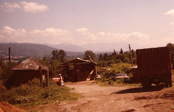
Out buildings on Lubbock farm
https://search.heritageburnaby.ca/link/museumdescription12808
- Repository
- Burnaby Village Museum
- Date
- 1977
- Collection/Fonds
- Century Park Museum Association fonds
- Description Level
- Item
- Physical Description
- 1 photograph : col. slide ; 35 mm
- Scope and Content
- Photograph of various outbuildings on the Lubbock farm. The old Vorce station building is visible on the left.
- Repository
- Burnaby Village Museum
- Collection/Fonds
- Century Park Museum Association fonds
- Description Level
- Item
- Physical Description
- 1 photograph : col. slide ; 35 mm
- Scope and Content
- Photograph of various outbuildings on the Lubbock farm. The old Vorce station building is visible on the left.
- History
- In 1977, Century Park Museum was granted access to the Sprott-Lubbock farm to appraise the heritage buildings for preservation. Buildings that were saved included the old farrier shed (BV985.1240.2) which was also used as a blacksmith shop and the Vorce tram station building (BV985.1240.3) from the old Burnaby Lake Interurban line which was used as a grain storage shed on the property. Segments of the original farmhouse and other out buildings were retained. Other buildings on the site were demolished to make way for a new housing development.
- Subjects
- Agriculture - Farms
- Names
- Lubbock farm
- Geographic Access
- Grandview Highway
- Burris Street
- Street Address
- 7803 Burris Street
- Accession Code
- BV020.5.475
- Access Restriction
- No restrictions
- Reproduction Restriction
- No known restrictions
- Date
- 1977
- Media Type
- Photograph
- Historic Neighbourhood
- Burnaby Lake (Historic Neighbourhood)
- Planning Study Area
- Morley-Buckingham Area
- Scan Resolution
- 2400
- Scan Date
- 13-Mar-20
- Scale
- 100
- Notes
- Title based on contents of photograph
Images
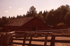
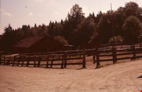
Paddock and barn
https://search.heritageburnaby.ca/link/museumdescription12807
- Repository
- Burnaby Village Museum
- Date
- 1977
- Collection/Fonds
- Century Park Museum Association fonds
- Description Level
- Item
- Physical Description
- 1 photograph : col. slide ; 35 mm
- Scope and Content
- Photograph of a fenced paddock and barn on the Lubbock farm.
- Repository
- Burnaby Village Museum
- Collection/Fonds
- Century Park Museum Association fonds
- Description Level
- Item
- Physical Description
- 1 photograph : col. slide ; 35 mm
- Scope and Content
- Photograph of a fenced paddock and barn on the Lubbock farm.
- History
- In 1977, Century Park Museum was granted access to the Sprott-Lubbock farm to appraise the heritage buildings for preservation. Buildings that were saved included the old farrier shed (BV985.1240.2) which was also used as a blacksmith shop and the Vorce tram station building (BV985.1240.3) from the old Burnaby Lake Interurban line which was used as a grain storage shed on the property. Segments of the original farmhouse and other out buildings were retained. Other buildings on the site were demolished to make way for a new housing development.
- Subjects
- Agriculture - Farms
- Names
- Lubbock farm
- Geographic Access
- Grandview Highway
- Burris Street
- Street Address
- 7803 Burris Street
- Accession Code
- BV020.5.474
- Access Restriction
- No restrictions
- Reproduction Restriction
- No known restrictions
- Date
- 1977
- Media Type
- Photograph
- Historic Neighbourhood
- Burnaby Lake (Historic Neighbourhood)
- Planning Study Area
- Morley-Buckingham Area
- Scan Resolution
- 2400
- Scan Date
- 13-Mar-20
- Scale
- 100
- Notes
- Title based on contents of photograph
Images

Paddock and barn
https://search.heritageburnaby.ca/link/museumdescription12814
- Repository
- Burnaby Village Museum
- Date
- 1977
- Collection/Fonds
- Century Park Museum Association fonds
- Description Level
- Item
- Physical Description
- 1 photograph : col. slide ; 35 mm
- Scope and Content
- Photograph of a fenced paddock and barn on the Lubbock family farm.
- Repository
- Burnaby Village Museum
- Collection/Fonds
- Century Park Museum Association fonds
- Description Level
- Item
- Physical Description
- 1 photograph : col. slide ; 35 mm
- Scope and Content
- Photograph of a fenced paddock and barn on the Lubbock family farm.
- History
- In 1977, Century Park Museum was granted access to the Sprott-Lubbock farm to appraise the heritage buildings for preservation. Buildings that were saved included the old farrier shed (BV985.1240.2) which was also used as a blacksmith shop and the Vorce tram station building (BV985.1240.3) from the old Burnaby Lake Interurban line which was used as a grain storage shed on the property. Segments of the original farmhouse and other out buildings were retained. Other buildings on the site were demolished to make way for a new housing development.
- Subjects
- Agriculture - Farms
- Names
- Lubbock farm
- Geographic Access
- Grandview Highway
- Burris Street
- Street Address
- 7803 Burris Street
- Accession Code
- BV020.5.481
- Access Restriction
- No restrictions
- Reproduction Restriction
- No known restrictions
- Date
- 1977
- Media Type
- Photograph
- Historic Neighbourhood
- Burnaby Lake (Historic Neighbourhood)
- Planning Study Area
- Morley-Buckingham Area
- Scan Resolution
- 2400
- Scan Date
- 13-Mar-20
- Scale
- 100
- Notes
- Title based on contents of photograph
Images

![Phillips Dairy Farm, [192-] (date of original), copied 1986 thumbnail](/media/hpo/_Data/_Archives_Images/_Unrestricted/204/204-515.jpg?width=280)
Phillips Dairy Farm
https://search.heritageburnaby.ca/link/archivedescription35657
- Repository
- City of Burnaby Archives
- Date
- [192-] (date of original), copied 1986
- Collection/Fonds
- Burnaby Historical Society fonds
- Description Level
- Item
- Physical Description
- 1 photograph : b&w ; 12.7 x 17.8 cm print
- Scope and Content
- Photograph of dairy cows on the Phillips farm leased by the family. The farm covered 500 acres at the foot of Byrne Road near Mandeville in the Big Bend area of South Burnaby.
- Repository
- City of Burnaby Archives
- Date
- [192-] (date of original), copied 1986
- Collection/Fonds
- Burnaby Historical Society fonds
- Subseries
- Pioneer Tales subseries
- Physical Description
- 1 photograph : b&w ; 12.7 x 17.8 cm print
- Description Level
- Item
- Record No.
- 204-515
- Access Restriction
- No restrictions
- Reproduction Restriction
- No known restrictions
- Accession Number
- BHS1988-03
- Scope and Content
- Photograph of dairy cows on the Phillips farm leased by the family. The farm covered 500 acres at the foot of Byrne Road near Mandeville in the Big Bend area of South Burnaby.
- Subjects
- Animals - Cows
- Agriculture - Farms
- Media Type
- Photograph
- Notes
- Title based on contents of photograph
- Pioneer Tales describes the amount of land leased as 100 acres
- Geographic Access
- Byrne Road
- Street Address
- 5670 Byrne Road
- Historic Neighbourhood
- Fraser Arm (Historic Neighbourhood)
- Planning Study Area
- Big Bend Area
Images
![Phillips Dairy Farm, [192-] (date of original), copied 1986 thumbnail](/media/hpo/_Data/_Archives_Images/_Unrestricted/204/204-515.jpg)
![Phillips Dairy Farm, [192-] (date of original), copied 1986 thumbnail](/media/hpo/_Data/_Archives_Images/_Unrestricted/204/204-519.jpg?width=280)
Phillips Dairy Farm
https://search.heritageburnaby.ca/link/archivedescription35661
- Repository
- City of Burnaby Archives
- Date
- [192-] (date of original), copied 1986
- Collection/Fonds
- Burnaby Historical Society fonds
- Description Level
- Item
- Physical Description
- 1 photograph : b&w ; 12.7 x 17.8 cm print
- Scope and Content
- Photograph of Phillips dairy farm at 515 Byrne Road (later renumbered 5670 Byrne Road). The dairy and barn are shown with Norman Phillips (son of John and Lily Phillips).
- Repository
- City of Burnaby Archives
- Date
- [192-] (date of original), copied 1986
- Collection/Fonds
- Burnaby Historical Society fonds
- Subseries
- Pioneer Tales subseries
- Physical Description
- 1 photograph : b&w ; 12.7 x 17.8 cm print
- Description Level
- Item
- Record No.
- 204-519
- Access Restriction
- No restrictions
- Reproduction Restriction
- No known restrictions
- Accession Number
- BHS1988-03
- Scope and Content
- Photograph of Phillips dairy farm at 515 Byrne Road (later renumbered 5670 Byrne Road). The dairy and barn are shown with Norman Phillips (son of John and Lily Phillips).
- Media Type
- Photograph
- Notes
- Title based on contents of photograph
- Geographic Access
- Byrne Road
- Street Address
- 5670 Byrne Road
- Historic Neighbourhood
- Fraser Arm (Historic Neighbourhood)
- Planning Study Area
- Big Bend Area
Images
![Phillips Dairy Farm, [192-] (date of original), copied 1986 thumbnail](/media/hpo/_Data/_Archives_Images/_Unrestricted/204/204-519.jpg)
![Piggery Brooder at Oakalla, [195-] (date of original), copied 1991 thumbnail](/media/hpo/_Data/_Archives_Images/_Unrestricted/370/370-713.jpg?width=280)
Piggery Brooder at Oakalla
https://search.heritageburnaby.ca/link/archivedescription38126
- Repository
- City of Burnaby Archives
- Date
- [195-] (date of original), copied 1991
- Collection/Fonds
- Burnaby Historical Society fonds
- Description Level
- Item
- Physical Description
- 1 photograph : b&w ; 3.1 x 4.6 cm print on contact sheet 20.1 x 26.5 cm
- Scope and Content
- Photograph of the exterior of the piggery brooder building at Oakalla Prison Farm.
- Repository
- City of Burnaby Archives
- Date
- [195-] (date of original), copied 1991
- Collection/Fonds
- Burnaby Historical Society fonds
- Subseries
- Burnaby Image Bank subseries
- Physical Description
- 1 photograph : b&w ; 3.1 x 4.6 cm print on contact sheet 20.1 x 26.5 cm
- Description Level
- Item
- Record No.
- 370-713
- Access Restriction
- No restrictions
- Reproduction Restriction
- Reproduce for fair dealing purposes only
- Accession Number
- BHS1999-03
- Scope and Content
- Photograph of the exterior of the piggery brooder building at Oakalla Prison Farm.
- Subjects
- Buildings - Agricultural - Barns
- Agriculture - Farms
- Buildings - Public - Detention Facilities
- Names
- Oakalla Prison Farm
- Media Type
- Photograph
- Notes
- Title based on contents of photograph
- 1 b&w copy negative accompanying
- Negative has a pink cast
- Geographic Access
- Oakmount Crescent
- Street Address
- 5220 Oakmount Crescent
- Historic Neighbourhood
- Burnaby Lake (Historic Neighbourhood)
- Planning Study Area
- Oakalla Area
Images
![Piggery Brooder at Oakalla, [195-] (date of original), copied 1991 thumbnail](/media/hpo/_Data/_Archives_Images/_Unrestricted/370/370-713.jpg)
![Piggery Building at Oakalla, [195-] (date of original), copied 1991 thumbnail](/media/hpo/_Data/_Archives_Images/_Unrestricted/370/370-711.jpg?width=280)
Piggery Building at Oakalla
https://search.heritageburnaby.ca/link/archivedescription38124
- Repository
- City of Burnaby Archives
- Date
- [195-] (date of original), copied 1991
- Collection/Fonds
- Burnaby Historical Society fonds
- Description Level
- Item
- Physical Description
- 1 photograph : b&w ; 3.2 x 4.5 cm print on contact sheet 20.1 x 26.5 cm
- Scope and Content
- Photograph of the exterior of the piggery building at Oakalla Prison Farm.
- Repository
- City of Burnaby Archives
- Date
- [195-] (date of original), copied 1991
- Collection/Fonds
- Burnaby Historical Society fonds
- Subseries
- Burnaby Image Bank subseries
- Physical Description
- 1 photograph : b&w ; 3.2 x 4.5 cm print on contact sheet 20.1 x 26.5 cm
- Description Level
- Item
- Record No.
- 370-711
- Access Restriction
- No restrictions
- Reproduction Restriction
- Reproduce for fair dealing purposes only
- Accession Number
- BHS1999-03
- Scope and Content
- Photograph of the exterior of the piggery building at Oakalla Prison Farm.
- Subjects
- Buildings - Agricultural - Barns
- Agriculture - Farms
- Buildings - Public - Detention Facilities
- Names
- Oakalla Prison Farm
- Media Type
- Photograph
- Notes
- Title based on contents of photograph
- 1 b&w copy negative accompanying
- Negative has a pink cast
- Geographic Access
- Oakmount Crescent
- Street Address
- 5220 Oakmount Crescent
- Historic Neighbourhood
- Burnaby Lake (Historic Neighbourhood)
- Planning Study Area
- Oakalla Area
Images
![Piggery Building at Oakalla, [195-] (date of original), copied 1991 thumbnail](/media/hpo/_Data/_Archives_Images/_Unrestricted/370/370-711.jpg)
![Piggery Runs at Oakalla, [195-] (date of original), copied 1991 thumbnail](/media/hpo/_Data/_Archives_Images/_Unrestricted/370/370-712.jpg?width=280)
Piggery Runs at Oakalla
https://search.heritageburnaby.ca/link/archivedescription38125
- Repository
- City of Burnaby Archives
- Date
- [195-] (date of original), copied 1991
- Collection/Fonds
- Burnaby Historical Society fonds
- Description Level
- Item
- Physical Description
- 1 photograph : b&w ; 3.1 x 4.6 cm print on contact sheet 20.1 x 26.5 cm
- Scope and Content
- Photograph of the piggery runs at Oakalla Prison Farm.
- Repository
- City of Burnaby Archives
- Date
- [195-] (date of original), copied 1991
- Collection/Fonds
- Burnaby Historical Society fonds
- Subseries
- Burnaby Image Bank subseries
- Physical Description
- 1 photograph : b&w ; 3.1 x 4.6 cm print on contact sheet 20.1 x 26.5 cm
- Description Level
- Item
- Record No.
- 370-712
- Access Restriction
- No restrictions
- Reproduction Restriction
- Reproduce for fair dealing purposes only
- Accession Number
- BHS1999-03
- Scope and Content
- Photograph of the piggery runs at Oakalla Prison Farm.
- Subjects
- Buildings - Agricultural - Barns
- Agriculture - Farms
- Buildings - Public - Detention Facilities
- Names
- Oakalla Prison Farm
- Media Type
- Photograph
- Notes
- Title based on contents of photograph
- 1 b&w copy negative accompanying
- Negative has a pink cast
- Geographic Access
- Oakmount Crescent
- Street Address
- 5220 Oakmount Crescent
- Historic Neighbourhood
- Burnaby Lake (Historic Neighbourhood)
- Planning Study Area
- Oakalla Area
Images
![Piggery Runs at Oakalla, [195-] (date of original), copied 1991 thumbnail](/media/hpo/_Data/_Archives_Images/_Unrestricted/370/370-712.jpg)
![Planning Map of Chinese Market Gardens on Marine Drive, [between 1950 and 1959] (date of original), 2017 (date of duplication) thumbnail](/media/hpo/_Data/_BVM_Images/2017/2017_0040_0002_001.jpg?width=280)
Planning Map of Chinese Market Gardens on Marine Drive
https://search.heritageburnaby.ca/link/museumdescription4297
- Repository
- Burnaby Village Museum
- Date
- [between 1950 and 1959] (date of original), 2017 (date of duplication)
- Collection/Fonds
- Herbert Yee Law family fonds
- Description Level
- Item
- Physical Description
- 1 photograph (tiff) : col. ; 300 dpi
- Scope and Content
- Scanned copy of a survey plan of district lots 163, 162, 157, 158, and 165, near the Chinese Market Gardens along Marine Drive.
- Repository
- Burnaby Village Museum
- Collection/Fonds
- Herbert Yee Law family fonds
- Description Level
- Item
- Physical Description
- 1 photograph (tiff) : col. ; 300 dpi
- Scope and Content
- Scanned copy of a survey plan of district lots 163, 162, 157, 158, and 165, near the Chinese Market Gardens along Marine Drive.
- History
- Survey plan of district lots 163, 162, 157, 158, and 165, which is primarily the area farmed by Chinese and Chinese-Canadian market gardeners around Marine Drive between Royal Oak and Mandeville (present-day Nelson). Two Chinese/Chinese Canadian land owners can be seen on the map: N.G. Wah Sing (or Ng Wah Sing) and Yee Law (or Herbert Law).
- Geographic Access
- Marine Drive
- Accession Code
- BV017.40.2
- Access Restriction
- No restrictions
- Reproduction Restriction
- No known restrictions
- Date
- [between 1950 and 1959] (date of original), 2017 (date of duplication)
- Media Type
- Cartographic Material
- Historic Neighbourhood
- Fraser Arm (Historic Neighbourhood)
- Planning Study Area
- Big Bend Area
- Scan Resolution
- 300
- Scan Date
- 11/19/2017
- Scale
- 100
- Notes
- Title based on contents of copy scan of map
- Herbert Yee Law was donor's father and this map may have originally been his copy of the city planning/engineering documents.
Images
![Planning Map of Chinese Market Gardens on Marine Drive, [between 1950 and 1959] (date of original), 2017 (date of duplication) thumbnail](/media/hpo/_Data/_BVM_Images/2017/2017_0040_0002_001.jpg)

Ploughing at Nicholson farm
https://search.heritageburnaby.ca/link/archivedescription38261
- Repository
- City of Burnaby Archives
- Date
- 1931
- Collection/Fonds
- Burnaby Historical Society fonds
- Description Level
- Item
- Physical Description
- 1 photograph : b&w ; 10.5 x 15.4 cm
- Scope and Content
- Photograph of four farmers and a team of horses ploughing a field and the E.W. Nicholson farm in the Broadview district. In the background, to the right, can be seen the Dominion Bridge Co. building (at 3880 Henning Drive).
- Repository
- City of Burnaby Archives
- Date
- 1931
- Collection/Fonds
- Burnaby Historical Society fonds
- Subseries
- Margaret McCallum subseries
- Physical Description
- 1 photograph : b&w ; 10.5 x 15.4 cm
- Description Level
- Item
- Record No.
- 375-023
- Access Restriction
- No restrictions
- Reproduction Restriction
- No known restrictions
- Accession Number
- BHS1986-42
- Scope and Content
- Photograph of four farmers and a team of horses ploughing a field and the E.W. Nicholson farm in the Broadview district. In the background, to the right, can be seen the Dominion Bridge Co. building (at 3880 Henning Drive).
- Subjects
- Agriculture - Farms
- Occupations - Farmers
- Transportation - Horses
- Agricultural Tools and Equipment - Plows
- Media Type
- Photograph
- Notes
- Title based on caption
- A note on the back of the photograph reads: "Ploughing on farm of Mr. E.W. Nicholson - Boundary Road and Great Northern Rlwy. John McCallum in foreground. Dominion Bridge Co. in background.)
- Geographic Access
- Boundary Road
- Henning Drive
- Street Address
- 2550 Boundary Road
- 3880 Henning Drive
- Historic Neighbourhood
- Broadview (Historic Neighbourhood)
- Planning Study Area
- West Central Valley Area
Images

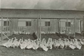
Poultry farm
https://search.heritageburnaby.ca/link/archivedescription34505
- Repository
- City of Burnaby Archives
- Date
- 1930
- Collection/Fonds
- Burnaby Historical Society fonds
- Description Level
- Item
- Physical Description
- 1 photograph : b&w ; 20.3 x 25.5 cm print
- Scope and Content
- Photograph of an unidentified poultry farm. A group of ducks is in front of a fence, and chickens are in pens are behind them.
- Repository
- City of Burnaby Archives
- Date
- 1930
- Collection/Fonds
- Burnaby Historical Society fonds
- Subseries
- Photographs subseries
- Physical Description
- 1 photograph : b&w ; 20.3 x 25.5 cm print
- Description Level
- Item
- Record No.
- 026-001
- Access Restriction
- No restrictions
- Reproduction Restriction
- No known restrictions
- Accession Number
- BHS2007-04
- Scope and Content
- Photograph of an unidentified poultry farm. A group of ducks is in front of a fence, and chickens are in pens are behind them.
- Subjects
- Agriculture - Farms
- Animals - Poultry
- Media Type
- Photograph
- Notes
- Title based on contents of photograph
Images

Poultry farm
https://search.heritageburnaby.ca/link/archivedescription35873
- Repository
- City of Burnaby Archives
- Date
- 1930 (date of original), copied 1986
- Collection/Fonds
- Burnaby Historical Society fonds
- Description Level
- Item
- Physical Description
- 1 photograph : b&w ; 12.7 x 17.8 cm print
- Scope and Content
- Photograph of an unidentified poultry farm, South Burnaby.
- Repository
- City of Burnaby Archives
- Date
- 1930 (date of original), copied 1986
- Collection/Fonds
- Burnaby Historical Society fonds
- Subseries
- Pioneer Tales subseries
- Physical Description
- 1 photograph : b&w ; 12.7 x 17.8 cm print
- Description Level
- Item
- Record No.
- 204-732
- Access Restriction
- No restrictions
- Reproduction Restriction
- No known restrictions
- Accession Number
- BHS1988-03
- Scope and Content
- Photograph of an unidentified poultry farm, South Burnaby.
- Subjects
- Animals - Poultry
- Agriculture - Farms
- Media Type
- Photograph
- Notes
- Title based on contents of photograph
Images


Price Strawberry farm
https://search.heritageburnaby.ca/link/archivedescription35946
- Repository
- City of Burnaby Archives
- Date
- 1920 (date of original), copied 1986
- Collection/Fonds
- Burnaby Historical Society fonds
- Description Level
- Item
- Physical Description
- 1 photograph : b&w ; 7.6 x 12.7 cm print
- Scope and Content
- Photograph of the Price Strawberry farm at 5220 Royal Oak Avenue. Oakalla Prison Farm can be seen in the background.
- Repository
- City of Burnaby Archives
- Date
- 1920 (date of original), copied 1986
- Collection/Fonds
- Burnaby Historical Society fonds
- Subseries
- Pioneer Tales subseries
- Physical Description
- 1 photograph : b&w ; 7.6 x 12.7 cm print
- Description Level
- Item
- Record No.
- 204-806
- Access Restriction
- No restrictions
- Reproduction Restriction
- No known restrictions
- Accession Number
- BHS1988-03
- Scope and Content
- Photograph of the Price Strawberry farm at 5220 Royal Oak Avenue. Oakalla Prison Farm can be seen in the background.
- Names
- Oakalla Prison Farm
- Media Type
- Photograph
- Notes
- Title based on contents of photograph
- Geographic Access
- Oakmount Crescent
- Street Address
- 5220 Oakmount Crescent
- Historic Neighbourhood
- Burnaby Lake (Historic Neighbourhood)
- Planning Study Area
- Oakalla Area
Images


Rooted : Chinese Canadian stories in Burnaby
https://search.heritageburnaby.ca/link/museumlibrary7646
- Repository
- Burnaby Village Museum
- Collection
- Digital Reference Collection
- Material Type
- Digital Resource
- ISBN
- 978-0-9689849-2-5
- Call Number
- 971.133 ROO
- Contributor
- Fong, Denise
- Lemke, Jane
- Codd, Lisa
- Place of Publication
- Burnaby
- Publisher
- City of Burnaby
- Publication Date
- 2023
- Printer
- Metropolitan Fine Printers
- Physical Description
- 203 p. : ill. ; 30.5 cm
- Library Subject (LOC)
- Chinese Canadians--British Columbia--Burnaby--History
- Race discrimination -- Canada
- Subjects
- Persons - Chinese Canadians
- Agriculture
- Agriculture - Farms
- Persons - Families
- Rights
- Rights - Human Rights
- Social Issues
- Social Issues - Racism
- Notes
- There are two versions of the book: English and Simplified Chinese (left, below) and the other in English and Traditional Chinese (right, below).
- From the late 1800s to the present day, Chinese Canadians have made Burnaby into a more vibrant and livable city. Rooted: Chinese Canadian Stories in Burnaby brings together a collection of diverse stories and photographs from the community, celebrating the legacy and contributions of Burnaby’s Chinese Canadian community spanning over a century. This coffee-table book features oral histories and interviews with descendants of multigenerational family farms, green grocers, corner stores, restaurants, and places of worship. Also included are archival research and community perspectives on anti-Asian racism, community activism, courage, and resilience.
- The publication has been timed to coincide with the 100th anniversary of the introduction of the Chinese Exclusion Act by the Government of Canada in 1923. This federal legislation followed decades of discriminatory legislation by Canada’s federal, provincial and municipal governments that targeted Chinese Canadians by limiting opportunities to live, work and raise families in Canada. The Chinese Exclusion Act banned almost all migration from China and remained in place until 1947. Publishing this book in 2023 is an effort by the City of Burnaby to recognize the impact of discriminatory legislation on Chinese Canadians in our community, including discriminatory bylaws and practices implemented by Burnaby’s early municipal government.
- Edited by Denise Fong (Lead Researcher), Jane Lemke (Burnaby Village Museum Curator) and Lisa Codd (City of Burnaby Heritage Planner).
Images

Digital Books
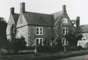
Rowborough Farm
https://search.heritageburnaby.ca/link/archivedescription36206
- Repository
- City of Burnaby Archives
- Date
- 1963
- Collection/Fonds
- Burnaby Historical Society fonds
- Description Level
- Item
- Physical Description
- 1 photograph : b&w ; 7.5 x 11.5 cm print
- Scope and Content
- Photograph of a very large stone building called the Rowborogh Farm, the Love family home in England.
- Repository
- City of Burnaby Archives
- Date
- 1963
- Collection/Fonds
- Burnaby Historical Society fonds
- Subseries
- Love family subseries
- Physical Description
- 1 photograph : b&w ; 7.5 x 11.5 cm print
- Description Level
- Item
- Record No.
- 232-003
- Access Restriction
- No restrictions
- Reproduction Restriction
- Reproduce for fair dealing purposes only
- Accession Number
- BHS1989-24
- Scope and Content
- Photograph of a very large stone building called the Rowborogh Farm, the Love family home in England.
- Media Type
- Photograph
- Notes
- Title based on contents of photograph
- 1 b&w copy negative accompanying
Images

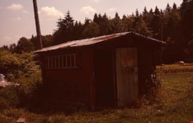
Shack at 7400 Block Halifax Street
https://search.heritageburnaby.ca/link/archivedescription78993
- Repository
- City of Burnaby Archives
- Date
- September 7, 1976
- Collection/Fonds
- Burnaby Public Library Contemporary Visual Archive Project
- Description Level
- Item
- Physical Description
- 1 photograph : b&w ; 11 x 16 cm mounted on cardboard
- Scope and Content
- Photograph shows an old shack in the 7400 Block Halifax Street built in approximately 1930. The shack was a boiler shed for what was then a 40-acre farm specializing in pigs and horses.
- Repository
- City of Burnaby Archives
- Date
- September 7, 1976
- Collection/Fonds
- Burnaby Public Library Contemporary Visual Archive Project
- Physical Description
- 1 photograph : b&w ; 11 x 16 cm mounted on cardboard
- Description Level
- Item
- Record No.
- 556-078
- Access Restriction
- No restrictions
- Reproduction Restriction
- Reproduce for fair dealing purposes only
- Accession Number
- 2013-13
- Scope and Content
- Photograph shows an old shack in the 7400 Block Halifax Street built in approximately 1930. The shack was a boiler shed for what was then a 40-acre farm specializing in pigs and horses.
- Subjects
- Agriculture - Farms
- Media Type
- Photograph
- Photographer
- Born, A. J.
- Notes
- Scope note taken directly from BPL photograph description.
- 1 b&w copy negative : 10 x 12.5 cm accompanying
- Geographic Access
- Halifax Street
- Historic Neighbourhood
- Lochdale (Historic Neighbourhood)
- Planning Study Area
- Sperling-Broadway Area
Images

![Shawn Wade in Big Bend, [2002] thumbnail](/media/hpo/_Data/_Archives_Images/_Unrestricted/535/535-2910.jpg?width=280)
Shawn Wade in Big Bend
https://search.heritageburnaby.ca/link/archivedescription97571
- Repository
- City of Burnaby Archives
- Date
- [2002]
- Collection/Fonds
- Burnaby NewsLeader photograph collection
- Description Level
- Item
- Physical Description
- 1 photograph (tiff) : col.
- Scope and Content
- Photograph of Shawn Wade standing on the shoulder of a road in the Big Bend area. A farm and forested area are visible in the background.
- Repository
- City of Burnaby Archives
- Date
- [2002]
- Collection/Fonds
- Burnaby NewsLeader photograph collection
- Physical Description
- 1 photograph (tiff) : col.
- Description Level
- Item
- Record No.
- 535-2910
- Access Restriction
- No restrictions
- Reproduction Restriction
- No restrictions
- Accession Number
- 2018-12
- Scope and Content
- Photograph of Shawn Wade standing on the shoulder of a road in the Big Bend area. A farm and forested area are visible in the background.
- Media Type
- Photograph
- Photographer
- Bartel, Mario
- Notes
- Title based on caption
- Collected by editorial for use in a January 2002 issue of the Burnaby NewsLeader
- Caption from metadata: "Shawn Wade fears the unique rural character of Burnaby's Big Bend area will die if Burnaby council approves a plan for commercial development."
- Historic Neighbourhood
- Fraser Arm (Historic Neighbourhood)
- Planning Study Area
- Big Bend Area
Images
![Shawn Wade in Big Bend, [2002] thumbnail](/media/hpo/_Data/_Archives_Images/_Unrestricted/535/535-2910.jpg)
![The Spinney, [1915] thumbnail](/media/hpo/_Data/_Archives_Images/_Unrestricted/477/477-652.jpg?width=280)
The Spinney
https://search.heritageburnaby.ca/link/archivedescription39333
- Repository
- City of Burnaby Archives
- Date
- [1915]
- Collection/Fonds
- Peers Family and Hill Family fonds
- Description Level
- Item
- Physical Description
- 1 photograph : b&w ; 6 x 10.2 cm on page 24.5 x 32.5 cm (pasted in album)
- Scope and Content
- Photograph looking north towards the Pole Line Road (Sperling Avenue) from the farm of Claude Hill. The photograph has been captioned "The Spinney."
- Repository
- City of Burnaby Archives
- Date
- [1915]
- Collection/Fonds
- Peers Family and Hill Family fonds
- Physical Description
- 1 photograph : b&w ; 6 x 10.2 cm on page 24.5 x 32.5 cm (pasted in album)
- Description Level
- Item
- Record No.
- 477-652
- Access Restriction
- No restrictions
- Reproduction Restriction
- No known restrictions
- Accession Number
- 2007-12
- Scope and Content
- Photograph looking north towards the Pole Line Road (Sperling Avenue) from the farm of Claude Hill. The photograph has been captioned "The Spinney."
- Subjects
- Agriculture - Farms
- Media Type
- Photograph
- Notes
- Title based on caption accompanying photograph
- Geographic Access
- Sperling Avenue
- Historic Neighbourhood
- Burnaby Lake (Historic Neighbourhood)
- Planning Study Area
- Morley-Buckingham Area
Images
![The Spinney, [1915] thumbnail](/media/hpo/_Data/_Archives_Images/_Unrestricted/477/477-652.jpg)
![Stiglish family dog, [196-] (date of original), digitally copied 2013 thumbnail](/media/hpo/_Data/_Archives_Images/_Unrestricted/550/552-001.jpg?width=280)
Stiglish family dog
https://search.heritageburnaby.ca/link/archivedescription77187
- Repository
- City of Burnaby Archives
- Date
- [196-] (date of original), digitally copied 2013
- Collection/Fonds
- Stiglish family fonds
- Description Level
- Item
- Physical Description
- 1 photograph : b&w copy-print ; 9 x 9 cm
- Scope and Content
- Photograph of Dinah, the Stiglish family's Rough Collie on the family property (this property included the F.J. Stiglish mushroom farm). Mushroom houses are visible in the background.
- Repository
- City of Burnaby Archives
- Date
- [196-] (date of original), digitally copied 2013
- Collection/Fonds
- Stiglish family fonds
- Physical Description
- 1 photograph : b&w copy-print ; 9 x 9 cm
- Description Level
- Item
- Record No.
- 552-001
- Access Restriction
- No restrictions
- Reproduction Restriction
- Reproduce for fair dealing purposes only
- Accession Number
- 2013-07
- Scope and Content
- Photograph of Dinah, the Stiglish family's Rough Collie on the family property (this property included the F.J. Stiglish mushroom farm). Mushroom houses are visible in the background.
- Subjects
- Agriculture - Farms
- Animals - Dogs
- Names
- Stiglish, F.J. "Jack"
- Media Type
- Photograph
- Notes
- Title based on contents of photograph
- Note in blue ink on verso of photograph reads: "F.J. Stiglish mushroom farm / 3782 Keswick Ave / Burnaby 3 / before changed address 1050 Keswick Ave / probably 1960s / mushroom houses in background garage with a suite above it, used for parties."
- Original spelling of surname was "Stiglich"
- Geographic Access
- Keswick Avenue
- Street Address
- 3782 Keswick Avenue
- Historic Neighbourhood
- Burquitlam (Historic Neighbourhood)
- Planning Study Area
- Cameron Area
Images
![Stiglish family dog, [196-] (date of original), digitally copied 2013 thumbnail](/media/hpo/_Data/_Archives_Images/_Unrestricted/550/552-001.jpg)
![Stoney Creek student with a pumpkin, [1999] thumbnail](/media/hpo/_Data/_Archives_Images/_Unrestricted/535/535-3365.jpg?width=280)
Stoney Creek student with a pumpkin
https://search.heritageburnaby.ca/link/archivedescription98355
- Repository
- City of Burnaby Archives
- Date
- [1999]
- Collection/Fonds
- Burnaby NewsLeader photograph collection
- Description Level
- Item
- Physical Description
- 1 photograph (tiff) : col.
- Scope and Content
- Photograph of Stoney Creek Elementary School student Michael Cao holding a pumpkin and wearing a backpack while standing in the field of the Laity Pumpkin Farm in Maple Ridge.
- Repository
- City of Burnaby Archives
- Date
- [1999]
- Collection/Fonds
- Burnaby NewsLeader photograph collection
- Physical Description
- 1 photograph (tiff) : col.
- Description Level
- Item
- Record No.
- 535-3365
- Access Restriction
- No restrictions
- Reproduction Restriction
- No restrictions
- Accession Number
- 2018-12
- Scope and Content
- Photograph of Stoney Creek Elementary School student Michael Cao holding a pumpkin and wearing a backpack while standing in the field of the Laity Pumpkin Farm in Maple Ridge.
- Media Type
- Photograph
- Photographer
- Ray, Steve
- Notes
- Title based on caption
- Collected by editorial for use in an October 1999 issue of the Burnaby NewsLeader
- Caption from metadata: "Michael Cao from Stoney Creek Elementary carries his pumpkin across the field at the Laity pumpkin farm in Maple Ridge on Thursday morning."
Images
![Stoney Creek student with a pumpkin, [1999] thumbnail](/media/hpo/_Data/_Archives_Images/_Unrestricted/535/535-3365.jpg)
![Suey Ying Jung (Laura) and boy, [between 1946 and 1955] thumbnail](/media/hpo/_Data/_BVM_Images/2017/2017_0024_0022_001.jpg?width=280)
Suey Ying Jung (Laura) and boy
https://search.heritageburnaby.ca/link/museumdescription4068
- Repository
- Burnaby Village Museum
- Date
- [between 1946 and 1955]
- Collection/Fonds
- Julie Lee and Cecil Lee family fonds
- Description Level
- Item
- Physical Description
- 1 photograph (tiff) : sepia ; 1200 dpi
- Scope and Content
- Photograph of Suey Ying Jung (Laura) crouching beside a small unidentified boy; family house on left of photograph.
- Repository
- Burnaby Village Museum
- Collection/Fonds
- Julie Lee and Cecil Lee family fonds
- Description Level
- Item
- Physical Description
- 1 photograph (tiff) : sepia ; 1200 dpi
- Scope and Content
- Photograph of Suey Ying Jung (Laura) crouching beside a small unidentified boy; family house on left of photograph.
- Names
- Jung, Suey Ying "Laura"
- Accession Code
- BV017.24.22
- Access Restriction
- No restrictions
- Reproduction Restriction
- No known restrictions
- Date
- [between 1946 and 1955]
- Media Type
- Photograph
- Historic Neighbourhood
- Burnaby Lake (Historic Neighbourhood)
- Planning Study Area
- Douglas-Gilpin Area
- Scan Resolution
- 1200
- Scan Date
- 01-Oct-2017
- Scale
- 100
- Notes
- Title based on contents of photograph
Images
![Suey Ying Jung (Laura) and boy, [between 1946 and 1955] thumbnail](/media/hpo/_Data/_BVM_Images/2017/2017_0024_0022_001.jpg)
![Suey Ying Jung (Laura) and friend, [between 1946 and 1955] thumbnail](/media/hpo/_Data/_BVM_Images/2017/2017_0024_0021_001.jpg?width=280)
Suey Ying Jung (Laura) and friend
https://search.heritageburnaby.ca/link/museumdescription4067
- Repository
- Burnaby Village Museum
- Date
- [between 1946 and 1955]
- Collection/Fonds
- Julie Lee and Cecil Lee family fonds
- Description Level
- Item
- Physical Description
- 1 photograph (tiff) : sepia ; 1200 dpi
- Scope and Content
- Photograph of Suey Ying Jung (Laura) (L) and a friend hugging; family house on left of the photo.
- Repository
- Burnaby Village Museum
- Collection/Fonds
- Julie Lee and Cecil Lee family fonds
- Description Level
- Item
- Physical Description
- 1 photograph (tiff) : sepia ; 1200 dpi
- Scope and Content
- Photograph of Suey Ying Jung (Laura) (L) and a friend hugging; family house on left of the photo.
- Names
- Jung, Suey Ying "Laura"
- Accession Code
- BV017.24.21
- Access Restriction
- No restrictions
- Reproduction Restriction
- No known restrictions
- Date
- [between 1946 and 1955]
- Media Type
- Photograph
- Historic Neighbourhood
- Burnaby Lake (Historic Neighbourhood)
- Planning Study Area
- Douglas-Gilpin Area
- Scan Resolution
- 1200
- Scan Date
- 01-Oct-2017
- Scale
- 100
- Notes
- Title based on contents of photograph
Images
![Suey Ying Jung (Laura) and friend, [between 1946 and 1955] thumbnail](/media/hpo/_Data/_BVM_Images/2017/2017_0024_0021_001.jpg)
![Suey Ying Jung (Laura) and Julie Cho Chan Lee, [between 1946 and 1952] thumbnail](/media/hpo/_Data/_BVM_Images/2017/2017_0024_0013_001.jpg?width=280)
Suey Ying Jung (Laura) and Julie Cho Chan Lee
https://search.heritageburnaby.ca/link/museumdescription4060
- Repository
- Burnaby Village Museum
- Date
- [between 1946 and 1952]
- Collection/Fonds
- Julie Lee and Cecil Lee family fonds
- Description Level
- Item
- Physical Description
- 1 photograph (tiff) : sepia ; 1200 dpi
- Scope and Content
- Photograph of Suey Ying Jung (Laura) sitting next to a standing Julie Cho Chan Lee; dog in foreground; family home in background.
- Repository
- Burnaby Village Museum
- Collection/Fonds
- Julie Lee and Cecil Lee family fonds
- Description Level
- Item
- Physical Description
- 1 photograph (tiff) : sepia ; 1200 dpi
- Scope and Content
- Photograph of Suey Ying Jung (Laura) sitting next to a standing Julie Cho Chan Lee; dog in foreground; family home in background.
- Accession Code
- BV017.24.13
- Access Restriction
- No restrictions
- Reproduction Restriction
- No known restrictions
- Date
- [between 1946 and 1952]
- Media Type
- Photograph
- Historic Neighbourhood
- Burnaby Lake (Historic Neighbourhood)
- Planning Study Area
- Douglas-Gilpin Area
- Scan Resolution
- 1200
- Scan Date
- 01-Oct-2017
- Scale
- 100
- Notes
- Title based on contents of photograph
Images
![Suey Ying Jung (Laura) and Julie Cho Chan Lee, [between 1946 and 1952] thumbnail](/media/hpo/_Data/_BVM_Images/2017/2017_0024_0013_001.jpg)
![Suey Ying Jung (Laura) lying on grass, [between 1946 and 1955] thumbnail](/media/hpo/_Data/_BVM_Images/2017/2017_0024_0014_001.jpg?width=280)
Suey Ying Jung (Laura) lying on grass
https://search.heritageburnaby.ca/link/museumdescription4061
- Repository
- Burnaby Village Museum
- Date
- [between 1946 and 1955]
- Collection/Fonds
- Julie Lee and Cecil Lee family fonds
- Description Level
- Item
- Physical Description
- 1 photograph (tiff) : sepia ; 1200 dpi
- Scope and Content
- Photograph of Suey Ying Jung (Laura) lying on grass; lattice and plants in background.
- Repository
- Burnaby Village Museum
- Collection/Fonds
- Julie Lee and Cecil Lee family fonds
- Description Level
- Item
- Physical Description
- 1 photograph (tiff) : sepia ; 1200 dpi
- Scope and Content
- Photograph of Suey Ying Jung (Laura) lying on grass; lattice and plants in background.
- Names
- Jung, Suey Ying "Laura"
- Accession Code
- BV017.24.14
- Access Restriction
- No restrictions
- Reproduction Restriction
- No known restrictions
- Date
- [between 1946 and 1955]
- Media Type
- Photograph
- Historic Neighbourhood
- Burnaby Lake (Historic Neighbourhood)
- Planning Study Area
- Douglas-Gilpin Area
- Scan Resolution
- 1200
- Scan Date
- 01-Oct-2017
- Scale
- 100
- Notes
- Title based on contents of photograph
Images
![Suey Ying Jung (Laura) lying on grass, [between 1946 and 1955] thumbnail](/media/hpo/_Data/_BVM_Images/2017/2017_0024_0014_001.jpg)
![Suey Ying Jung (Laura) with children and dog, [between 1946 and 1952] thumbnail](/media/hpo/_Data/_BVM_Images/2017/2017_0024_0028_001.jpg?width=280)
Suey Ying Jung (Laura) with children and dog
https://search.heritageburnaby.ca/link/museumdescription4075
- Repository
- Burnaby Village Museum
- Date
- [between 1946 and 1952]
- Collection/Fonds
- Julie Lee and Cecil Lee family fonds
- Description Level
- Item
- Physical Description
- 1 photograph (tiff) : sepia ; 1200 dpi
- Scope and Content
- Photograph of Suey Ying Jung (Laura) holding shovel; two children on porch of house; black and white dog sitting in front; view of family property on right.
- Repository
- Burnaby Village Museum
- Collection/Fonds
- Julie Lee and Cecil Lee family fonds
- Description Level
- Item
- Physical Description
- 1 photograph (tiff) : sepia ; 1200 dpi
- Scope and Content
- Photograph of Suey Ying Jung (Laura) holding shovel; two children on porch of house; black and white dog sitting in front; view of family property on right.
- Names
- Jung, Suey Ying "Laura"
- Accession Code
- BV017.24.28
- Access Restriction
- No restrictions
- Reproduction Restriction
- No known restrictions
- Date
- [between 1946 and 1952]
- Media Type
- Photograph
- Historic Neighbourhood
- Burnaby Lake (Historic Neighbourhood)
- Planning Study Area
- Douglas-Gilpin Area
- Scan Resolution
- 1200
- Scan Date
- 01-Oct-2017
- Scale
- 100
- Notes
- Title based on contents of photograph
Images
![Suey Ying Jung (Laura) with children and dog, [between 1946 and 1952] thumbnail](/media/hpo/_Data/_BVM_Images/2017/2017_0024_0028_001.jpg)
![Suey Ying Jung (Laura) with produce baskets, [between 1940 and 1942] thumbnail](/media/hpo/_Data/_BVM_Images/2017/2017_0024_0026_001.jpg?width=280)
Suey Ying Jung (Laura) with produce baskets
https://search.heritageburnaby.ca/link/museumdescription4073
- Repository
- Burnaby Village Museum
- Date
- [between 1940 and 1942]
- Collection/Fonds
- Julie Lee and Cecil Lee family fonds
- Description Level
- Item
- Physical Description
- 1 photograph (tiff) : sepia ; 1000 dpi
- Scope and Content
- Photograph of Suey Ying Jung (Laura) wearing sunglasses and overalls, sitting in front of family home with produce baskets balanced on pole.
- Repository
- Burnaby Village Museum
- Collection/Fonds
- Julie Lee and Cecil Lee family fonds
- Description Level
- Item
- Physical Description
- 1 photograph (tiff) : sepia ; 1000 dpi
- Scope and Content
- Photograph of Suey Ying Jung (Laura) wearing sunglasses and overalls, sitting in front of family home with produce baskets balanced on pole.
- Names
- Jung, Suey Ying "Laura"
- Geographic Access
- Douglas Road
- Accession Code
- BV017.24.26
- Access Restriction
- No restrictions
- Reproduction Restriction
- No known restrictions
- Date
- [between 1940 and 1942]
- Media Type
- Photograph
- Historic Neighbourhood
- Burnaby Lake (Historic Neighbourhood)
- Planning Study Area
- Douglas-Gilpin Area
- Scan Resolution
- 1000
- Scan Date
- 01-Oct-2017
- Scale
- 100
- Notes
- Title based on contents of photograph
Images
![Suey Ying Jung (Laura) with produce baskets, [between 1940 and 1942] thumbnail](/media/hpo/_Data/_BVM_Images/2017/2017_0024_0026_001.jpg)
![Suey Ying Jung (Laura) with produce baskets, [between 1940 and 1942] thumbnail](/media/hpo/_Data/_BVM_Images/2017/2017_0024_0027_001.jpg?width=280)
Suey Ying Jung (Laura) with produce baskets
https://search.heritageburnaby.ca/link/museumdescription4074
- Repository
- Burnaby Village Museum
- Date
- [between 1940 and 1942]
- Collection/Fonds
- Julie Lee and Cecil Lee family fonds
- Description Level
- Item
- Physical Description
- 1 photograph (tiff) : sepia ; 1000 dpi
- Scope and Content
- Photograph of Suey Ying Jung (Laura) wearing overalls, sitting between produce baskets in front of family home.
- Repository
- Burnaby Village Museum
- Collection/Fonds
- Julie Lee and Cecil Lee family fonds
- Description Level
- Item
- Physical Description
- 1 photograph (tiff) : sepia ; 1000 dpi
- Scope and Content
- Photograph of Suey Ying Jung (Laura) wearing overalls, sitting between produce baskets in front of family home.
- Names
- Jung, Suey Ying "Laura"
- Accession Code
- BV017.24.27
- Access Restriction
- No restrictions
- Reproduction Restriction
- No known restrictions
- Date
- [between 1940 and 1942]
- Media Type
- Photograph
- Historic Neighbourhood
- Burnaby Lake (Historic Neighbourhood)
- Planning Study Area
- Douglas-Gilpin Area
- Scan Resolution
- 1000
- Scan Date
- 01-Oct-2017
- Scale
- 100
- Notes
- Title based on contents of photograph
Images
![Suey Ying Jung (Laura) with produce baskets, [between 1940 and 1942] thumbnail](/media/hpo/_Data/_BVM_Images/2017/2017_0024_0027_001.jpg)
Thould family
https://search.heritageburnaby.ca/link/archivedescription35768
- Repository
- City of Burnaby Archives
- Date
- 1929 (date of original), copied 1986
- Collection/Fonds
- Burnaby Historical Society fonds
- Description Level
- Item
- Physical Description
- 1 photograph : b&w ; 12.7 x 17.8 cm print
- Scope and Content
- Photograph of the Thould family. Back, left to right: Grace Dommett Thould (wife) and Lionel "Judge" Thould (husband). Front left to right: Eileen Thould (daughter), Margaret Thould (daughter), and pet dog, Jack. This photograph was taken at the family's home and farm, 5665 Portland Street in Al…
- Repository
- City of Burnaby Archives
- Date
- 1929 (date of original), copied 1986
- Collection/Fonds
- Burnaby Historical Society fonds
- Subseries
- Pioneer Tales subseries
- Physical Description
- 1 photograph : b&w ; 12.7 x 17.8 cm print
- Description Level
- Item
- Record No.
- 204-626
- Access Restriction
- No restrictions
- Reproduction Restriction
- No known restrictions
- Accession Number
- BHS1988-03
- Scope and Content
- Photograph of the Thould family. Back, left to right: Grace Dommett Thould (wife) and Lionel "Judge" Thould (husband). Front left to right: Eileen Thould (daughter), Margaret Thould (daughter), and pet dog, Jack. This photograph was taken at the family's home and farm, 5665 Portland Street in Alta Vista.
- Media Type
- Photograph
- Notes
- Title based on contents of photograph
- Geographic Access
- Portland Street
- Street Address
- 5665 Portland Street
- Historic Neighbourhood
- Alta-Vista (Historic Neighbourhood)
- Planning Study Area
- Clinton-Glenwood Area
Images

![Three men with tractor, [193-] thumbnail](/media/hpo/_Data/_BVM_Images/2022/2022_0032_0350_001.jpg?width=280)
Three men with tractor
https://search.heritageburnaby.ca/link/museumdescription19928
- Repository
- Burnaby Village Museum
- Date
- [193-]
- Collection/Fonds
- Esther Love Stanley fonds
- Description Level
- Item
- Physical Description
- 1 photograph : b&w ; 6.5 x 8.5 cm
- Scope and Content
- Photograph of three men with a tractor on a farm in Champion, Alberta. Frank Charles "Stan" Stanley is seated in the drivers' seat of the tractor and two men are standing next to the tractor. One of the men is holding a gas can. There are farm buildings and metal storage drums in the background.
- Repository
- Burnaby Village Museum
- Collection/Fonds
- Esther Love Stanley fonds
- Description Level
- Item
- Physical Description
- 1 photograph : b&w ; 6.5 x 8.5 cm
- Scope and Content
- Photograph of three men with a tractor on a farm in Champion, Alberta. Frank Charles "Stan" Stanley is seated in the drivers' seat of the tractor and two men are standing next to the tractor. One of the men is holding a gas can. There are farm buildings and metal storage drums in the background.
- Accession Code
- BV022.32.350
- Access Restriction
- No restrictions
- Reproduction Restriction
- No known restrictions
- Date
- [193-]
- Media Type
- Photograph
- Scan Resolution
- 600
- Scan Date
- 2023-06-09
- Notes
- Title based on contents of photograph
- Photograph is part of Esther Love Stanley photograph album 1 (BV022.32.1)
- Note in white ink on album page reads: "Champion._Alta"
Images
![Three men with tractor, [193-] thumbnail](/media/hpo/_Data/_BVM_Images/2022/2022_0032_0350_001.jpg)
![Thrussell farm and barn, [1914] thumbnail](/media/hpo/_Data/_Archives_Images/_Unrestricted/251/275-009.jpg?width=280)
Thrussell farm and barn
https://search.heritageburnaby.ca/link/archivedescription36477
- Repository
- City of Burnaby Archives
- Date
- [1914]
- Collection/Fonds
- Burnaby Historical Society fonds
- Description Level
- Item
- Physical Description
- 1 photograph : b&w ; 8.5 x 12.5 cm print
- Scope and Content
- Photograph of the Thrussell family farm, including the front gate and barn on Marine Drive, at Nelson Avenue.
- Repository
- City of Burnaby Archives
- Date
- [1914]
- Collection/Fonds
- Burnaby Historical Society fonds
- Subseries
- Thrussell family subseries
- Physical Description
- 1 photograph : b&w ; 8.5 x 12.5 cm print
- Description Level
- Item
- Record No.
- 275-009
- Access Restriction
- No restrictions
- Reproduction Restriction
- No known restrictions
- Accession Number
- BHS1992-05
- Scope and Content
- Photograph of the Thrussell family farm, including the front gate and barn on Marine Drive, at Nelson Avenue.
- Names
- North Arm Dairy
- Media Type
- Photograph
- Notes
- Title based on contents of photograph
- Geographic Access
- Marine Drive
- Nelson Avenue
- Historic Neighbourhood
- Fraser Arm (Historic Neighbourhood)
- Planning Study Area
- Big Bend Area
Images
![Thrussell farm and barn, [1914] thumbnail](/media/hpo/_Data/_Archives_Images/_Unrestricted/251/275-009.jpg)
![Thrussell's farm, [1900] thumbnail](/media/hpo/_Data/_Archives_Images/_Unrestricted/251/275-001.jpg?width=280)
Thrussell's farm
https://search.heritageburnaby.ca/link/archivedescription36470
- Repository
- City of Burnaby Archives
- Date
- [1900]
- Collection/Fonds
- Burnaby Historical Society fonds
- Description Level
- Item
- Physical Description
- 1 photograph : b&w ; 8.5 x 12.5 cm print
- Scope and Content
- Photograph of the North Arm Dairy and the rest of the Thrussell family farm at Marine Drive and Nelson Avenue. Froggers Creek is visible on the left.
- Repository
- City of Burnaby Archives
- Date
- [1900]
- Collection/Fonds
- Burnaby Historical Society fonds
- Subseries
- Thrussell family subseries
- Physical Description
- 1 photograph : b&w ; 8.5 x 12.5 cm print
- Description Level
- Item
- Record No.
- 275-001
- Access Restriction
- No restrictions
- Reproduction Restriction
- No known restrictions
- Accession Number
- BHS1992-05
- Scope and Content
- Photograph of the North Arm Dairy and the rest of the Thrussell family farm at Marine Drive and Nelson Avenue. Froggers Creek is visible on the left.
- Names
- North Arm Dairy
- Media Type
- Photograph
- Notes
- Title based on contents of photograph
- Geographic Access
- Marine Drive
- Nelson Avenue
- Historic Neighbourhood
- Fraser Arm (Historic Neighbourhood)
- Planning Study Area
- Big Bend Area
Images
![Thrussell's farm, [1900] thumbnail](/media/hpo/_Data/_Archives_Images/_Unrestricted/251/275-001.jpg)

Towards Nicholson Farm
https://search.heritageburnaby.ca/link/archivedescription38256
- Repository
- City of Burnaby Archives
- Date
- 1933
- Collection/Fonds
- Burnaby Historical Society fonds
- Description Level
- Item
- Physical Description
- 1 photograph : b&w ; 7 x 11.5 cm
- Scope and Content
- Photograph looking over a field towards a house and barn in the background. The farm has been identified as that belonging to E.W. Nicholson of the Broadview district.
- Repository
- City of Burnaby Archives
- Date
- 1933
- Collection/Fonds
- Burnaby Historical Society fonds
- Subseries
- Margaret McCallum subseries
- Physical Description
- 1 photograph : b&w ; 7 x 11.5 cm
- Description Level
- Item
- Record No.
- 375-018
- Access Restriction
- No restrictions
- Reproduction Restriction
- No known restrictions
- Accession Number
- BHS1986-42
- Scope and Content
- Photograph looking over a field towards a house and barn in the background. The farm has been identified as that belonging to E.W. Nicholson of the Broadview district.
- Subjects
- Agriculture - Farms
- Buildings - Agricultural - Barns
- Agriculture - Crops
- Buildings - Residential - Houses
- Media Type
- Photograph
- Notes
- Title based on caption.
- A note on the back of the photograph reads: "Haying time on farm of E.W. Nicholson."
- Geographic Access
- Boundary Road
- Street Address
- 2550 Boundary Road
- Historic Neighbourhood
- Broadview (Historic Neighbourhood)
- Planning Study Area
- West Central Valley Area
Images

![Trailers on the Stiglish property, [196-] (date of original), digitally copied 2013 thumbnail](/media/hpo/_Data/_Archives_Images/_Unrestricted/550/552-007.jpg?width=280)
Trailers on the Stiglish property
https://search.heritageburnaby.ca/link/archivedescription77193
- Repository
- City of Burnaby Archives
- Date
- [196-] (date of original), digitally copied 2013
- Collection/Fonds
- Stiglish family fonds
- Description Level
- Item
- Physical Description
- 1 photograph : b&w copy-print ; 9 x 9 cm
- Scope and Content
- Photograph of the overflow of Jehovah Witness convention goers staying on the Stiglish property because the four acre trailer park, in Coquitlam, British Columbia that Jack Stiglish owned, was full.
- Repository
- City of Burnaby Archives
- Date
- [196-] (date of original), digitally copied 2013
- Collection/Fonds
- Stiglish family fonds
- Physical Description
- 1 photograph : b&w copy-print ; 9 x 9 cm
- Description Level
- Item
- Record No.
- 552-007
- Access Restriction
- No restrictions
- Reproduction Restriction
- Reproduce for fair dealing purposes only
- Accession Number
- 2013-07
- Scope and Content
- Photograph of the overflow of Jehovah Witness convention goers staying on the Stiglish property because the four acre trailer park, in Coquitlam, British Columbia that Jack Stiglish owned, was full.
- Names
- Stiglish, F.J. "Jack"
- Media Type
- Photograph
- Notes
- Title based on contents of photograph
- Note in blue ink on verso of photograph reads: "father owned four acre Trailer Court in Coquitlam / Jehovah Witness convention overflow from trailer park"
- Original spelling of surname was "Stiglich"
- Geographic Access
- Keswick Avenue
- Street Address
- 3782 Keswick Avenue
- Historic Neighbourhood
- Burquitlam (Historic Neighbourhood)
- Planning Study Area
- Cameron Area
Images
![Trailers on the Stiglish property, [196-] (date of original), digitally copied 2013 thumbnail](/media/hpo/_Data/_Archives_Images/_Unrestricted/550/552-007.jpg)
![Two men with truck and trailer, [194-] thumbnail](/media/hpo/_Data/_BVM_Images/2022/2022_0032_0658_001.jpg?width=280)
Two men with truck and trailer
https://search.heritageburnaby.ca/link/museumdescription20236
- Repository
- Burnaby Village Museum
- Date
- [194-]
- Collection/Fonds
- Esther Love Stanley fonds
- Description Level
- Item
- Physical Description
- 1 photograph : b&w ; 6.5 x 8.5 cm
- Scope and Content
- Photograph of two men with truck and trailer in a field on a farm. Wooden buildings are visible in the background.
- Repository
- Burnaby Village Museum
- Collection/Fonds
- Esther Love Stanley fonds
- Description Level
- Item
- Physical Description
- 1 photograph : b&w ; 6.5 x 8.5 cm
- Scope and Content
- Photograph of two men with truck and trailer in a field on a farm. Wooden buildings are visible in the background.
- Accession Code
- BV022.32.658
- Access Restriction
- No restrictions
- Reproduction Restriction
- No known restrictions
- Date
- [194-]
- Media Type
- Photograph
- Scan Resolution
- 600
- Scan Date
- 2023-08-29
- Notes
- Title based on contents of photograph
- Photograph is part of Esther Love Stanley photograph album 2 (BV032.22.431)
Images
![Two men with truck and trailer, [194-] thumbnail](/media/hpo/_Data/_BVM_Images/2022/2022_0032_0658_001.jpg)
![Vegetable building at Oakalla, [195-] (date of original), copied 1991 thumbnail](/media/hpo/_Data/_Archives_Images/_Unrestricted/370/370-714.jpg?width=280)
Vegetable building at Oakalla
https://search.heritageburnaby.ca/link/archivedescription38127
- Repository
- City of Burnaby Archives
- Date
- [195-] (date of original), copied 1991
- Collection/Fonds
- Burnaby Historical Society fonds
- Description Level
- Item
- Physical Description
- 1 photograph : b&w ; 3.1 x 4.6 cm print on contact sheet 20.1 x 26.5 cm
- Scope and Content
- Photograph of the exterior of the vegetable building at Oakalla.
- Repository
- City of Burnaby Archives
- Date
- [195-] (date of original), copied 1991
- Collection/Fonds
- Burnaby Historical Society fonds
- Subseries
- Burnaby Image Bank subseries
- Physical Description
- 1 photograph : b&w ; 3.1 x 4.6 cm print on contact sheet 20.1 x 26.5 cm
- Description Level
- Item
- Record No.
- 370-714
- Access Restriction
- No restrictions
- Reproduction Restriction
- Reproduce for fair dealing purposes only
- Accession Number
- BHS1999-03
- Scope and Content
- Photograph of the exterior of the vegetable building at Oakalla.
- Names
- Oakalla Prison Farm
- Media Type
- Photograph
- Notes
- Title based on contents of photograph
- 1 b&w copy negative accompanying
- Negative has a pink cast
- Geographic Access
- Oakmount Crescent
- Street Address
- 5220 Oakmount Crescent
- Historic Neighbourhood
- Burnaby Lake (Historic Neighbourhood)
- Planning Study Area
- Oakalla Area
Images
![Vegetable building at Oakalla, [195-] (date of original), copied 1991 thumbnail](/media/hpo/_Data/_Archives_Images/_Unrestricted/370/370-714.jpg)
![View at back of mushroom houses, [before 1969] (date of original), digitally copied 2013 thumbnail](/media/hpo/_Data/_Archives_Images/_Unrestricted/550/552-005.jpg?width=280)
View at back of mushroom houses
https://search.heritageburnaby.ca/link/archivedescription77191
- Repository
- City of Burnaby Archives
- Date
- [before 1969] (date of original), digitally copied 2013
- Collection/Fonds
- Stiglish family fonds
- Description Level
- Item
- Physical Description
- 1 photograph : b&w copy-print ; 9 x 9 cm
- Scope and Content
- Photograph of the equipment at the back of the mushroom houses used to get compost ready to be used in the mushroom houses.
- Repository
- City of Burnaby Archives
- Date
- [before 1969] (date of original), digitally copied 2013
- Collection/Fonds
- Stiglish family fonds
- Physical Description
- 1 photograph : b&w copy-print ; 9 x 9 cm
- Description Level
- Item
- Record No.
- 552-005
- Access Restriction
- No restrictions
- Reproduction Restriction
- Reproduce for fair dealing purposes only
- Accession Number
- 2013-07
- Scope and Content
- Photograph of the equipment at the back of the mushroom houses used to get compost ready to be used in the mushroom houses.
- Media Type
- Photograph
- Notes
- Title based on contents of photograph
- Note in blue ink on verso of photograph reads: "curing [illegible] - with compost on for mushroom houses / at back of mushroom houses no 5 and no 6"
- Original spelling of surname was "Stiglich"
- Geographic Access
- Keswick Avenue
- Street Address
- 3782 Keswick Avenue
- Historic Neighbourhood
- Burquitlam (Historic Neighbourhood)
- Planning Study Area
- Cameron Area
Images
![View at back of mushroom houses, [before 1969] (date of original), digitally copied 2013 thumbnail](/media/hpo/_Data/_Archives_Images/_Unrestricted/550/552-005.jpg)
Vorce station and Lubbock grain shed
https://search.heritageburnaby.ca/link/museumdescription12772
- Repository
- Burnaby Village Museum
- Date
- 1977
- Collection/Fonds
- Century Park Museum Association fonds
- Description Level
- Item
- Physical Description
- 1 photograph : col. slide ; 35 mm
- Scope and Content
- Photograph of the former Vorce Interurban Tram station building which was used as grain storage shed on the Lubbock farm. The farm was located at 7803 Burris Street near Burnaby Lake. The building was moved from the farm to the site of Heritage Village in 1977.
- Repository
- Burnaby Village Museum
- Collection/Fonds
- Century Park Museum Association fonds
- Description Level
- Item
- Physical Description
- 1 photograph : col. slide ; 35 mm
- Scope and Content
- Photograph of the former Vorce Interurban Tram station building which was used as grain storage shed on the Lubbock farm. The farm was located at 7803 Burris Street near Burnaby Lake. The building was moved from the farm to the site of Heritage Village in 1977.
- History
- In 1977, Century Park Museum was granted access to the Sprott-Lubbock farm to appraise the heritage buildings for preservation. Buildings that were saved included the old farrier shed (BV985.1240.2) which was also used as a blacksmith shop and the Vorce tram station building (BV985.1240.3) from the old Burnaby Lake Interurban line which was used as a grain storage shed on the property. Segments of the original farmhouse and other out buildings were retained. Other buildings on the site were demolished to make way for a new housing development.
- Subjects
- Agriculture - Farms
- Names
- Lubbock farm
- Geographic Access
- Grandview Highway
- Burris Street
- Street Address
- 7803 Burris Street
- Accession Code
- BV020.5.449
- Access Restriction
- No restrictions
- Reproduction Restriction
- No known restrictions
- Date
- 1977
- Media Type
- Photograph
- Historic Neighbourhood
- Burnaby Lake (Historic Neighbourhood)
- Planning Study Area
- Morley-Buckingham Area
- Scan Resolution
- 2400
- Scan Date
- 13-Mar-20
- Scale
- 100
- Notes
- Title based on contents of photograph
Images

![W.H. Lewis farm, [1900] thumbnail](/media/hpo/_Data/_Archives_Images/_Unrestricted/001/022-002.jpg?width=280)
W.H. Lewis farm
https://search.heritageburnaby.ca/link/archivedescription34499
- Repository
- City of Burnaby Archives
- Date
- [1900]
- Collection/Fonds
- Burnaby Historical Society fonds
- Description Level
- Item
- Physical Description
- 1 photograph : sepia ; 12.6 x 17.7 cm mounted on cardboard 14.2 x 19.3 cm
- Scope and Content
- Photograph of W.H. Lewis' fruit farm with a man, three women and five children kneeling in a strawberry field. "Pioneer Tales" identifies them as William Lewis (foreground), three of his children, and hired help. A house can be seen in the background. The Lewis house was located on 4th Street.
- Repository
- City of Burnaby Archives
- Date
- [1900]
- Collection/Fonds
- Burnaby Historical Society fonds
- Subseries
- Photographs subseries
- Physical Description
- 1 photograph : sepia ; 12.6 x 17.7 cm mounted on cardboard 14.2 x 19.3 cm
- Description Level
- Item
- Record No.
- 022-002
- Access Restriction
- No restrictions
- Reproduction Restriction
- No known restrictions
- Accession Number
- BHS2007-04
- Scope and Content
- Photograph of W.H. Lewis' fruit farm with a man, three women and five children kneeling in a strawberry field. "Pioneer Tales" identifies them as William Lewis (foreground), three of his children, and hired help. A house can be seen in the background. The Lewis house was located on 4th Street.
- Media Type
- Photograph
- Photographer
- Cooksley, William Thomas
- Notes
- Title based on contents of photograph
- Annotation at bottom of photograph reads, "W.H. Lewis' Fruit Farm, Burnaby, B.C."
- Geographic Access
- 4th Street
- 18th Avenue
- Historic Neighbourhood
- East Burnaby (Historic Neighbourhood)
- Planning Study Area
- Second Street Area
Images
![W.H. Lewis farm, [1900] thumbnail](/media/hpo/_Data/_Archives_Images/_Unrestricted/001/022-002.jpg)
![William Brenchley farm, [between 1890 and 1895] (date of original), copied 1985 thumbnail](/media/hpo/_Data/_Archives_Images/_Unrestricted/126/146-002.jpg?width=280)
William Brenchley farm
https://search.heritageburnaby.ca/link/archivedescription34864
- Repository
- City of Burnaby Archives
- Date
- [between 1890 and 1895] (date of original), copied 1985
- Collection/Fonds
- Burnaby Historical Society fonds
- Description Level
- Item
- Physical Description
- 1 photograph : b&w ; 8.8 x 12.5 cm print
- Scope and Content
- Photograph of a farm hand and horse team inside a large stump, taken on William Brenchley's farm. The farm was located at the northeast corner of Kingsway and 10th Avenue.
- Repository
- City of Burnaby Archives
- Date
- [between 1890 and 1895] (date of original), copied 1985
- Collection/Fonds
- Burnaby Historical Society fonds
- Subseries
- W.E. Brenchley subseries
- Physical Description
- 1 photograph : b&w ; 8.8 x 12.5 cm print
- Description Level
- Item
- Record No.
- 146-002
- Access Restriction
- No restrictions
- Reproduction Restriction
- No known restrictions
- Accession Number
- BHS1985-16
- Scope and Content
- Photograph of a farm hand and horse team inside a large stump, taken on William Brenchley's farm. The farm was located at the northeast corner of Kingsway and 10th Avenue.
- Media Type
- Photograph
- Photographer
- Thompson, S.J.
- Notes
- Title based on contents of photograph
- Geographic Access
- 10th Avenue
- Kingsway
- Historic Neighbourhood
- Edmonds (Historic Neighbourhood)
- Planning Study Area
- Edmonds Area
Images
![William Brenchley farm, [between 1890 and 1895] (date of original), copied 1985 thumbnail](/media/hpo/_Data/_Archives_Images/_Unrestricted/126/146-002.jpg)
![Winter on the farm, [1901] (date of original), copied 1978 thumbnail](/media/hpo/_Data/_BVM_Images/1977/197800010012.jpg?width=280)
Winter on the farm
https://search.heritageburnaby.ca/link/museumdescription458
- Repository
- Burnaby Village Museum
- Date
- [1901] (date of original), copied 1978
- Collection/Fonds
- Burnaby Village Museum Photograph collection
- Description Level
- Item
- Physical Description
- 1 photograph : b&w ; 20.2 x 25.2 cm print
- Scope and Content
- Photograph of the Sprott farm property in the middle of winter, with trees, fields, buildings, and fences covered in snow. An annotation on the back of the photo reads: "On Mayfield farm in the middle of winter / looking towards Burnaby Lake."
- Repository
- Burnaby Village Museum
- Collection/Fonds
- Burnaby Village Museum Photograph collection
- Description Level
- Item
- Physical Description
- 1 photograph : b&w ; 20.2 x 25.2 cm print
- Scope and Content
- Photograph of the Sprott farm property in the middle of winter, with trees, fields, buildings, and fences covered in snow. An annotation on the back of the photo reads: "On Mayfield farm in the middle of winter / looking towards Burnaby Lake."
- Geographic Access
- Canada Way
- Accession Code
- HV978.1.12
- Access Restriction
- No restrictions
- Reproduction Restriction
- No known restrictions
- Date
- [1901] (date of original), copied 1978
- Media Type
- Photograph
- Historic Neighbourhood
- Burnaby Lake (Historic Neighbourhood)
- Planning Study Area
- Morley-Buckingham Area
- Scan Resolution
- 600
- Scan Date
- 2023-08-01
- Notes
- Title based on contents of photograph
- 1 b&w copy print accompanying
Images
![Winter on the farm, [1901] (date of original), copied 1978 thumbnail](/media/hpo/_Data/_BVM_Images/1977/197800010012.jpg)
![Woman holding two puppies, [1930] thumbnail](/media/hpo/_Data/_BVM_Images/2022/2022_0032_0329_001.jpg?width=280)
Woman holding two puppies
https://search.heritageburnaby.ca/link/museumdescription19907
- Repository
- Burnaby Village Museum
- Date
- [1930]
- Collection/Fonds
- Esther Love Stanley fonds
- Description Level
- Item
- Physical Description
- 1 photograph : b&w ; 6.5 x 11 cm
- Scope and Content
- Photograph of a woman seated outside with two black puppies on her lap. A house, windmill, farm machinery and field are visible in the background. The farm is located in Alberta.
- Repository
- Burnaby Village Museum
- Collection/Fonds
- Esther Love Stanley fonds
- Description Level
- Item
- Physical Description
- 1 photograph : b&w ; 6.5 x 11 cm
- Scope and Content
- Photograph of a woman seated outside with two black puppies on her lap. A house, windmill, farm machinery and field are visible in the background. The farm is located in Alberta.
- Subjects
- Animals - Dogs
- Agriculture - Farms
- Accession Code
- BV022.32.329
- Access Restriction
- No restrictions
- Reproduction Restriction
- No known restrictions
- Date
- [1930]
- Media Type
- Photograph
- Scan Resolution
- 600
- Scan Date
- 2023-06-09
- Notes
- Title based on contents of photograph
- Photograph is part of Esther Love Stanley photograph album 1 (BV022.32.1)
Images
![Woman holding two puppies, [1930] thumbnail](/media/hpo/_Data/_BVM_Images/2022/2022_0032_0329_001.jpg)
![Woman leaning on fence, [191-] thumbnail](/media/hpo/_Data/_BVM_Images/2022/2022_0032_0381_001.jpg?width=280)
Woman leaning on fence
https://search.heritageburnaby.ca/link/museumdescription19959
- Repository
- Burnaby Village Museum
- Date
- [191-]
- Collection/Fonds
- Esther Love Stanley fonds
- Description Level
- Item
- Physical Description
- 1 photograph : b&w ; 12 x 8 cm
- Scope and Content
- Photograph of an unidentified woman leaning a wooden rail fence with her left arm. The fence appears to be an enclosure for a field or pasture. Trees are visible in the distance.
- Repository
- Burnaby Village Museum
- Collection/Fonds
- Esther Love Stanley fonds
- Description Level
- Item
- Physical Description
- 1 photograph : b&w ; 12 x 8 cm
- Scope and Content
- Photograph of an unidentified woman leaning a wooden rail fence with her left arm. The fence appears to be an enclosure for a field or pasture. Trees are visible in the distance.
- Subjects
- Agriculture - Farms
- Accession Code
- BV022.32.381
- Access Restriction
- No restrictions
- Reproduction Restriction
- No known restrictions
- Date
- [191-]
- Media Type
- Photograph
- Scan Resolution
- 600
- Scan Date
- 2023-06-09
- Notes
- Title based on contents of photograph
- Photograph is part of Esther Love Stanley photograph album 1 (BV022.32.1)
Images
![Woman leaning on fence, [191-] thumbnail](/media/hpo/_Data/_BVM_Images/2022/2022_0032_0381_001.jpg)
![Woman with baby and dog, [1930] thumbnail](/media/hpo/_Data/_BVM_Images/2022/2022_0032_0330_001.jpg?width=280)
Woman with baby and dog
https://search.heritageburnaby.ca/link/museumdescription19908
- Repository
- Burnaby Village Museum
- Date
- [1930]
- Collection/Fonds
- Esther Love Stanley fonds
- Description Level
- Item
- Physical Description
- 1 photograph : b&w ; 11.5 x 7 cm
- Scope and Content
- Photograph of a woman holding a baby with dog standing next to her. The woman is standing on snow covered ground on a farm in Alberta. A house is visible in the background.
- Repository
- Burnaby Village Museum
- Collection/Fonds
- Esther Love Stanley fonds
- Description Level
- Item
- Physical Description
- 1 photograph : b&w ; 11.5 x 7 cm
- Scope and Content
- Photograph of a woman holding a baby with dog standing next to her. The woman is standing on snow covered ground on a farm in Alberta. A house is visible in the background.
- Subjects
- Agriculture - Farms
- Accession Code
- BV022.32.330
- Access Restriction
- No restrictions
- Reproduction Restriction
- No known restrictions
- Date
- [1930]
- Media Type
- Photograph
- Scan Resolution
- 600
- Scan Date
- 2023-06-09
- Notes
- Title based on contents of photograph
- Photograph is part of Esther Love Stanley photograph album 1 (BV022.32.1)
Images
![Woman with baby and dog, [1930] thumbnail](/media/hpo/_Data/_BVM_Images/2022/2022_0032_0330_001.jpg)
Working on roof of the Lubbock barn
https://search.heritageburnaby.ca/link/museumdescription12789
- Repository
- Burnaby Village Museum
- Date
- 1977
- Collection/Fonds
- Century Park Museum Association fonds
- Description Level
- Item
- Physical Description
- 1 photograph : col. slide ; 35 mm
- Scope and Content
- Photograph of two men standing on the roof of the Lubbock barn and working on dismantling segments. Tall brambles surround the barn and out buildings. The barn was located at 7803 Burris Street near Burnaby Lake.
- Repository
- Burnaby Village Museum
- Collection/Fonds
- Century Park Museum Association fonds
- Description Level
- Item
- Physical Description
- 1 photograph : col. slide ; 35 mm
- Scope and Content
- Photograph of two men standing on the roof of the Lubbock barn and working on dismantling segments. Tall brambles surround the barn and out buildings. The barn was located at 7803 Burris Street near Burnaby Lake.
- History
- In 1977, Century Park Museum was granted access to the Sprott-Lubbock farm to appraise the heritage buildings for preservation. Buildings that were saved included the old farrier shed (BV985.1240.2) which was also used as a blacksmith shop and the Vorce tram station building (BV985.1240.3) from the old Burnaby Lake Interurban line which was used as a grain storage shed on the property. Segments of the original farmhouse and other out buildings were retained. Other buildings on the site were demolished to make way for a new housing development.
- Subjects
- Agriculture - Farms
- Names
- Lubbock farm
- Geographic Access
- Grandview Highway
- Burris Street
- Street Address
- 7803 Burris Street
- Accession Code
- BV020.5.466
- Access Restriction
- No restrictions
- Reproduction Restriction
- No known restrictions
- Date
- 1977
- Media Type
- Photograph
- Historic Neighbourhood
- Burnaby Lake (Historic Neighbourhood)
- Planning Study Area
- Morley-Buckingham Area
- Scan Resolution
- 2400
- Scan Date
- 13-Mar-20
- Scale
- 100
- Notes
- Title based on contents of photograph
Images

![Young child outdoors, [1963 or 1964] thumbnail](/media/hpo/_Data/_Archives_Images/_Unrestricted/205/246-026.jpg?width=280)
Young child outdoors
https://search.heritageburnaby.ca/link/archivedescription52986
- Repository
- City of Burnaby Archives
- Date
- [1963 or 1964]
- Collection/Fonds
- Burnaby Historical Society fonds
- Description Level
- Item
- Physical Description
- 1 photograph : b&w ; 7.5 x 7.5 cm
- Scope and Content
- Photograph of a young child sitting on a blanket with a shopping bag on farmland. There is a jacket hanging on an outdoor oil tank behind the child.
- Repository
- City of Burnaby Archives
- Date
- [1963 or 1964]
- Collection/Fonds
- Burnaby Historical Society fonds
- Subseries
- Tinkerbell Kindergarten subseries
- Physical Description
- 1 photograph : b&w ; 7.5 x 7.5 cm
- Description Level
- Item
- Record No.
- 246-026
- Access Restriction
- No restrictions
- Reproduction Restriction
- Reproduce for fair dealing purposes only
- Accession Number
- BHS1990-12
- Scope and Content
- Photograph of a young child sitting on a blanket with a shopping bag on farmland. There is a jacket hanging on an outdoor oil tank behind the child.
- Media Type
- Photograph
- Notes
- Title based on contents of photograph
Images
![Young child outdoors, [1963 or 1964] thumbnail](/media/hpo/_Data/_Archives_Images/_Unrestricted/205/246-026.jpg)