Narrow Results By
Decade
- 2020s 91
- 2010s 221
- 2000s
- 1990s 542
- 1980s
- 1970s 1267
- 1960s 596
- 1950s 463
- 1940s
- 1930s 357
- 1920s
- 1910s
- 1900s 139
- 1890s 73
- 1880s 27
- 1870s 10
- 1860s 21
- 1850s 8
- 1840s 4
- 1830s 2
- 1820s 2
- 1810s 3
- 1800s 3
- 1790s 3
- 1780s 3
- 1770s 3
- 1760s 3
- 1750s 3
- 1740s 3
- 1730s 3
- 1720s 3
- 1710s 3
- 1700s 3
- 1690s 3
- 1680s 3
- 1670s 2
- 1660s 2
- 1650s 2
- 1640s 2
- 1630s 2
- 1620s 2
- 1610s 2
- 1600s 2
- 1590s 1
- 1580s 1
- 1570s 1
- 1560s 1
- 1550s 1
- 1540s 1
- 1530s 1
- 1520s 2
- 1510s 1
- 1500s 1
- 1490s 1
- 1480s 1
Creator
- Adams, Edith 1
- Adams, Morley 1
- Alberta. Alberta Culture 1
- Aldwinckle, Eric 1
- Allen, R. W., 1876-1921 1
- Alter, Ian 1
- Anger, Harry D. (Harry Dell), 1888-1953 1
- Anger, William Henry 1
- Angus, H. F. (Henry Forbes), 1891-1991 1
- Armstrong, W. H. (William Henry) 1
- Baden-Powell of Gilwell, Robert Stephenson Smyth Baden-Powell, Baron, 1857-1941 1
- Bagnell, Kenneth, 1934- 1
Medical Council of Canada, 13th annual announcement, September 15th, 1925: relating to registration under the Canada Medical Act, examination for the qualification of the Medical Council of Canada and the Canada Medical Register
https://search.heritageburnaby.ca/link/museumlibrary5568
- Repository
- Burnaby Village Museum
- Author
- Medical Council of Canada
- Publication Date
- 1925
- Call Number
- 610.6 MED
- Repository
- Burnaby Village Museum
- Collection
- Special Collection
- Material Type
- Book
- Accession Code
- BV994.14.11
- Call Number
- 610.6 MED
- Author
- Medical Council of Canada
- Place of Publication
- (Ottawa)
- Publication Date
- 1925
- Physical Description
- 79 p. ; 17cm.
- Inscription
- "Ultan P. Byrne" [handwritten in ink, upper right corner of cover]
- Library Subject (LOC)
- Medical Council of Canada--Examinations
- Physicians--Canada--Examinations
- Physicians--Licenses--Canada
- Notes
- Historical interest: provides information on applying for and obtaining a physician's license in Canada, including information about the qualifying examination ; p 24-79 is the "Canada Medical Register" a list of 1741 names, addresses, and dates of registration of persons licensed by the Medical Council of Canada at the time of publication (1925).
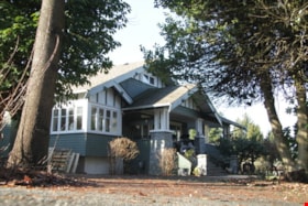
Captain William Eyres Residence
https://search.heritageburnaby.ca/link/landmark565
- Repository
- Burnaby Heritage Planning
- Description
- Residential building.
- Associated Dates
- c.1910
- Street View URL
- Google Maps Street View
- Repository
- Burnaby Heritage Planning
- Geographic Access
- Canada Way
- Associated Dates
- c.1910
- Description
- Residential building.
- Heritage Value
- This home was built by Captain William J. Eyres. In 1912, it was reported in The British Columbian: “Captain Eyres of Seattle is remodelling the front of his house on Douglas Road and otherwise improving it.” The house was later sold to William A. Mawhinney, who subsequently built houses at 6011 Buckingham Avenue and 7616 Burris Avenue. This spacious, high-quality Craftsman bungalow remains in excellent condition. It features a cross-gabled roof with multiple half-timbered front gables with large exposed purlins, in contrast to the shingle cladding on the rest of the house. At the front corner is a glazed sun-room. The entrance porch features tripled square columns. The property still has a beautiful garden, but once included large vegetable gardens, an orchard, and a large chicken house.
- Locality
- Burnaby Lake
- Historic Neighbourhood
- Burnaby Lake (Historic Neighbourhood)
- Planning Study Area
- Morley-Buckingham Area
- Area
- 1709.65
- Contributing Resource
- Building
- Ownership
- Private
- Street Address
- 6079 Canada Way
- Street View URL
- Google Maps Street View
Images
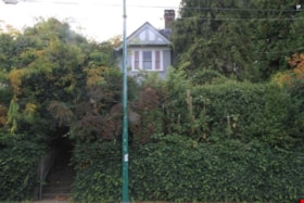
Douglas Road School
https://search.heritageburnaby.ca/link/landmark573
- Repository
- Burnaby Heritage Planning
- Description
- School building.
- Associated Dates
- 1928
- Other Names
- Douglas Road Elementary School
- Street View URL
- Google Maps Street View
- Repository
- Burnaby Heritage Planning
- Other Names
- Douglas Road Elementary School
- Geographic Access
- Canada Way
- Associated Dates
- 1928
- Description
- School building.
- Heritage Value
- The Douglas Road School was originally established as a two-room school in 1908 on this site, and later expanded to four classrooms. Anticipating rapid settlement of this district, the School Board purchased two acres adjoining the old building. Two of the four rooms were designed to become one large auditorium suitable for special events and public gatherings, with seating for two hundred people. The classically-influenced school has been altered with new windows and extended with additional wings, but has retained its original red-brick veneer, tan-brick quoins and bellcast octagonal roof ventilator. Designed by McCarter & Nairne, the school was built by contractor A.S. Perry. McCarter & Nairne, who also designed the Second Street School, were the Burnaby School Board architects at this time. John Y. McCarter (1886-1981) and George Nairne (1884-1953) formed their partnership in 1921 after serving overseas during the First World War. The partners began designing houses and small apartment buildings, and their commissions included Vancouver’s first skyscraper, the Marine Building (1928-30).
- Locality
- Burnaby Lake
- Historic Neighbourhood
- Burnaby Lake (Historic Neighbourhood)
- Planning Study Area
- Douglas-Gilpin Area
- Architect
- McCarter & Nairne
- Subjects
- Buildings - Heritage
- Buildings - Schools
- Street Address
- 4861 Canada Way
- Street View URL
- Google Maps Street View
Images
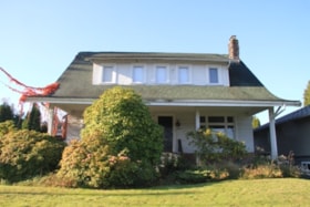
Geoffrey & Kathleen Burnett Residence
https://search.heritageburnaby.ca/link/landmark582
- Repository
- Burnaby Heritage Planning
- Description
- Residential building.
- Associated Dates
- 1914
- Formal Recognition
- Heritage Designation, Community Heritage Register
- Street View URL
- Google Maps Street View
- Repository
- Burnaby Heritage Planning
- Geographic Access
- Canada Way
- Associated Dates
- 1914
- Formal Recognition
- Heritage Designation, Community Heritage Register
- Enactment Type
- Bylaw No. 13841
- Enactment Date
- 28/05/2018
- Description
- Residential building.
- Heritage Value
- With its long, narrow plan and hipped, cross-gabled roof, this impressive residence was designed for local surveyor and civil engineer Geoffrey Kirby Burnett, who married Kathleen Wallen (1888-1978) in 1916. It was designed by New Westminster architects R.W. Coventry Dick & Son. Beautifully conceived in the British Arts and Crafts style, it features a steeply-gabled roof over the side entry porch, with square timber columns. Other decorative details include half timbering in the gables, first storey casement windows with leaded transom lights and decorative window hoods on the side elevation.
- Locality
- Edmonds
- Historic Neighbourhood
- Edmonds (Historic Neighbourhood)
- Planning Study Area
- Richmond Park Area
- Architect
- R.W. Coventry Dick & Son
- Area
- 903.70
- Contributing Resource
- Building
- Ownership
- Private
- Street Address
- 7037 Canada Way
- Street View URL
- Google Maps Street View
Images
Lonsdale Guardhouse Residence
https://search.heritageburnaby.ca/link/landmark617
- Repository
- Burnaby Heritage Planning
- Description
- Residential building.
- Associated Dates
- 1914
- Street View URL
- Google Maps Street View
- Repository
- Burnaby Heritage Planning
- Geographic Access
- Canada Way
- Associated Dates
- 1914
- Description
- Residential building.
- Heritage Value
- The house was built by Lonsdale L. Guardhouse, who was employed with the real estate company of Merithew & Ramsay in 1912. The British Columbian reported in November 1913 that: "Mr. L.L. Guardhouse, a well-known New Westminster man has recently let the contract for a home on Douglas Road near Edmonds Street. This Building is to be erected after the bungalow style and will cost when completed about $4,000." This Craftsman style pattern-book residence is notable for its unusual roofline, which features gently curved eaves. The house remains in excellent original condition and retains its lapped and shingled siding. Other notable features of the house include its pre-cast concrete block foundation–simulated to look like cut stone–and a rustic red-brick chimney. The front verandah has been altered through the removal of its floor structure. Many houses at the time were built from Craftsman-style pattern book designs, which were readily available in magazines and brochures. This house has a twin located in New Westminster at 315 Fifth Avenue.
- Locality
- Edmonds
- Historic Neighbourhood
- Edmonds (Historic Neighbourhood)
- Planning Study Area
- Richmond Park Area
- Area
- 828.85
- Contributing Resource
- Building
- Ownership
- Private
- Street Address
- 6985 Canada Way
- Street View URL
- Google Maps Street View
Images
6869 Canada Way C6-Zoned Property at Canada Way and Elwell Street
https://search.heritageburnaby.ca/link/councilreport14250
- Repository
- City of Burnaby Archives
- Report ID
- 8949
- Meeting Date
- 11-Jan-1988
- Format
- Council - Manager's Report
- Manager's Report No.
- 3
- Item No.
- 6
- Collection/Fonds
- City Council and Office of the City Clerk fonds
- Repository
- City of Burnaby Archives
- Report ID
- 8949
- Meeting Date
- 11-Jan-1988
- Format
- Council - Manager's Report
- Manager's Report No.
- 3
- Item No.
- 6
- Collection/Fonds
- City Council and Office of the City Clerk fonds
Documents
Development enquiry, Canadian Tire Company, Community Plan 8 Canada Way/Smith Avenue Area Apartment Study Area "I" (3841 Canada Way)
https://search.heritageburnaby.ca/link/councilreport18644
- Repository
- City of Burnaby Archives
- Report ID
- 2386
- Meeting Date
- 8-Feb-1982
- Format
- Council - Manager's Report
- Manager's Report No.
- 9
- Item No.
- 6
- Collection/Fonds
- City Council and Office of the City Clerk fonds
- Repository
- City of Burnaby Archives
- Report ID
- 2386
- Meeting Date
- 8-Feb-1982
- Format
- Council - Manager's Report
- Manager's Report No.
- 9
- Item No.
- 6
- Collection/Fonds
- City Council and Office of the City Clerk fonds
Documents
Development Inquiry, Community Plan 8 - Canada Way/Smith Avenue area Apartment Study Area "I" (3841 Canada Way) Canadian Tire
https://search.heritageburnaby.ca/link/councilreport18675
- Repository
- City of Burnaby Archives
- Report ID
- 2362
- Meeting Date
- 25-Jan-1982
- Format
- Council - Manager's Report
- Manager's Report No.
- 5
- Item No.
- 10
- Collection/Fonds
- City Council and Office of the City Clerk fonds
- Repository
- City of Burnaby Archives
- Report ID
- 2362
- Meeting Date
- 25-Jan-1982
- Format
- Council - Manager's Report
- Manager's Report No.
- 5
- Item No.
- 10
- Collection/Fonds
- City Council and Office of the City Clerk fonds
Documents
Proposed demolition of residential dwellings within Municipal Business Park 4547 and 4549 Canada Way (Northeast corner Canada Way and Willingdon Avenue)
https://search.heritageburnaby.ca/link/councilreport18108
- Repository
- City of Burnaby Archives
- Report ID
- 2921
- Meeting Date
- 8-Nov-1982
- Format
- Council - Manager's Report
- Manager's Report No.
- 62
- Item No.
- 3
- Collection/Fonds
- City Council and Office of the City Clerk fonds
- Repository
- City of Burnaby Archives
- Report ID
- 2921
- Meeting Date
- 8-Nov-1982
- Format
- Council - Manager's Report
- Manager's Report No.
- 62
- Item No.
- 3
- Collection/Fonds
- City Council and Office of the City Clerk fonds
Documents
Proposed relocation of a bus shelter from westbound Canada Way east of Willingdon Avenue to eastbound Canada Way east of Sperling
https://search.heritageburnaby.ca/link/councilreport19636
- Repository
- City of Burnaby Archives
- Report ID
- 1383
- Meeting Date
- 15-Sep-1980
- Format
- Council - Manager's Report
- Manager's Report No.
- 58
- Item No.
- 1
- Collection/Fonds
- City Council and Office of the City Clerk fonds
- Repository
- City of Burnaby Archives
- Report ID
- 1383
- Meeting Date
- 15-Sep-1980
- Format
- Council - Manager's Report
- Manager's Report No.
- 58
- Item No.
- 1
- Collection/Fonds
- City Council and Office of the City Clerk fonds
Documents
Proposed sale and development of Municipal Lands N.E. quadrant - Canada Way and Willingdon Avenue - Rem. Lot 45 DL 70 Plan 56349 (4545 Canada Way)
https://search.heritageburnaby.ca/link/councilreport19655
- Repository
- City of Burnaby Archives
- Report ID
- 1368
- Meeting Date
- 8-Sep-1980
- Format
- Council - Manager's Report
- Manager's Report No.
- 56
- Item No.
- 3
- Collection/Fonds
- City Council and Office of the City Clerk fonds
- Repository
- City of Burnaby Archives
- Report ID
- 1368
- Meeting Date
- 8-Sep-1980
- Format
- Council - Manager's Report
- Manager's Report No.
- 56
- Item No.
- 3
- Collection/Fonds
- City Council and Office of the City Clerk fonds
Documents
Road Closure Reference #00-4 X-Ref: PPA #00-269 & Sub. #01-17 Closure of a ptn. Of the unopened 11th Avenue Road Allowance at Canada Way and dedication for the widening of Canada Way
https://search.heritageburnaby.ca/link/councilreport3757
- Repository
- City of Burnaby Archives
- Report ID
- 63387
- Meeting Date
- 9-Apr-2001
- Format
- Council - Manager's Report
- Manager's Report No.
- 11
- Item No.
- 5
- Collection/Fonds
- City Council and Office of the City Clerk fonds
- Repository
- City of Burnaby Archives
- Report ID
- 63387
- Meeting Date
- 9-Apr-2001
- Format
- Council - Manager's Report
- Manager's Report No.
- 11
- Item No.
- 5
- Collection/Fonds
- City Council and Office of the City Clerk fonds
Documents
Who's who in western Canada : a bibliographical dictionary of notable living men and women of western Canada
https://search.heritageburnaby.ca/link/museumlibrary3393
- Repository
- Burnaby Village Museum
- Collection
- Special Collection
- Material Type
- Book
- Accession Code
- BV993.12.3
- Call Number
- 920 WHO
- Contributor
- Parker, C. W. (Charles Wallace), 1864-1932
- Place of Publication
- Vancouver
- Publisher
- Canadian Press Association
- Publication Date
- 1911
- Physical Description
- 390 p. : ill., ports. ; 20 cm.
- Library Subject (LOC)
- Canada
- Dictionaries
- Biography
- Notes
- "Edited by C.W. Parker" --t.p.
Who's who in western Canada : a bibliographical dictionary of notable living men and women of western Canada, volume 1
https://search.heritageburnaby.ca/link/museumlibrary1820
- Repository
- Burnaby Village Museum
- Collection
- Special Collection
- Material Type
- Book
- Accession Code
- HV983.61.2
- Call Number
- 920 WHO
- Contributor
- Parker, C. W. (Charles Wallace), 1864-1932
- Place of Publication
- Vancouver
- Publisher
- Canadian Press Association
- Publication Date
- 1911
- Physical Description
- 390 p. : ill., ports. ; 20 cm.
- Inscription
- "Presented to Burnaby Historical Society _______ B Brown __M_ Burnaby 1932 to 1959" [handwritten in blue ink on front endpaper]
- Library Subject (LOC)
- Canada
- Dictionaries
- Biography
- Notes
- "Edited by C.W. Parker" --title page
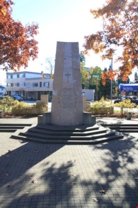
South Burnaby Cenotaph
https://search.heritageburnaby.ca/link/landmark860
- Repository
- Burnaby Heritage Planning
- Description
- The South Burnaby Cenotaph is located in Bonsor Park at the corner of Nelson Avenue and Imperial Street. The cenotaph commemorates those lost in the First World War, Second World War and the Korean War.
- Associated Dates
- 1988
- Other Names
- Bonsor Park Cenotaph
- Street View URL
- Google Maps Street View
- Repository
- Burnaby Heritage Planning
- Other Names
- Bonsor Park Cenotaph
- Geographic Access
- Nelson Avenue
- Associated Dates
- 1988
- Description
- The South Burnaby Cenotaph is located in Bonsor Park at the corner of Nelson Avenue and Imperial Street. The cenotaph commemorates those lost in the First World War, Second World War and the Korean War.
- Historic Neighbourhood
- Central Park (Historic Neighbourhood)
- Planning Study Area
- Marlborough Area
- Community
- Burnaby
- Cadastral Identifier
- P.I.D. No. 027-719-375
- Boundaries
- The property (Bonsor Park) is comprised of a single municipally-owned property located at 6749 Nelson Avenue.
- Area
- 3570.00
- Contributing Resource
- Landscape Feature
- Structure
- Ownership
- Public (local)
- Street Address
- 6749 Nelson Avenue
- Street View URL
- Google Maps Street View
Images
Excursions in northern British Columbia and Yukon Territory and along the North Pacific Coast : excursions C8 and C9; no.10
https://search.heritageburnaby.ca/link/museumlibrary537
- Repository
- Burnaby Village Museum
- Collection
- Special Collection
- Material Type
- Book
- Accession Code
- BV986.53.45
- Call Number
- 557.1 GSC
- Place of Publication
- Ottawa
- Publisher
- Government Printing Bureau
- Publication Date
- 1913
- Physical Description
- 179 p. : ill., maps (some folded) ; 20 cm.
- Inscription
- Stamped inside: "Kennco Library"
- Library Subject (LOC)
- Geology--British Columbia
- Geology--Yukon
- British Columbia--Description and travel
- Canada, Western--Description and travel
- Yukon--Description and travel
- Notes
- "Excursions C8 and C9."
- Six maps on folded leaves in pocket.
- Includes bibliographies.
The Labrador Eskimo, no. 1637
https://search.heritageburnaby.ca/link/museumlibrary1998
- Repository
- Burnaby Village Museum
- Collection
- Special Collection
- Material Type
- Book
- Accession Code
- HV980.2.13
- Call Number
- 970.4 HAW
- Place of Publication
- Ottawa
- Publisher
- Government Printing Bureau
- Publication Date
- 1916
- Physical Description
- x, 235 p., viii : ill., map ; 25 cm.
- Library Subject (LOC)
- Inuit--Newfoundland and Labrador--Labrador
- Inuit--Quebec (Province)
- Notes
- At head of title: Canada, Department of Mines, Geological Survey
- "No. 1637"
Cascades Drive-In Theatre
https://search.heritageburnaby.ca/link/landmark689
- Repository
- Burnaby Heritage Planning
- Geographic Access
- Grandview Highway
- Associated Dates
- 1946
- Heritage Value
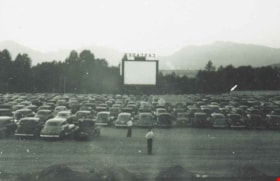
- The Cascades Drive-In Theatre was Canada's first drive-in and was started by George and William Steel and Joe and Art Johnson in 1946. Built along Grandview Highway (Canada Way) near Smith Street, the theatre opened on August 30, 1946. In 1977, the theatre was purchased by Don Soutar, Al Chappell and Norm Green and continued to operate until 1980. The property was then redeveloped as Cascades Village - a large condominium complex.
- Historic Neighbourhood
- Broadview (Historic Neighbourhood)
- Planning Study Area
- Cascade-Schou Area
- Street Address
- 4050 Grandview Highway
Images
Mortimer-Lamb House
https://search.heritageburnaby.ca/link/landmark494
- Repository
- Burnaby Heritage Planning
- Description
- The Mortimer-Lamb House is a one and one half-storey, Arts and Crafts-style residence with a steeply pitched, side-gabled roof. The original cottage form has been enlarged with a later addition on the west side of the house. Located next to the Burnaby Lake Regional Park Wildlife Rescue Care Centre…
- Associated Dates
- c.1922
- Formal Recognition
- Community Heritage Register
- Other Names
- Harold & Katherine Mortimer-Lamb Residence
- Street View URL
- Google Maps Street View
- Repository
- Burnaby Heritage Planning
- Other Names
- Harold & Katherine Mortimer-Lamb Residence
- Geographic Access
- Glencarin Drive
- Associated Dates
- c.1922
- Formal Recognition
- Community Heritage Register
- Enactment Type
- Council Resolution
- Enactment Date
- 26/05/2003
- Description
- The Mortimer-Lamb House is a one and one half-storey, Arts and Crafts-style residence with a steeply pitched, side-gabled roof. The original cottage form has been enlarged with a later addition on the west side of the house. Located next to the Burnaby Lake Regional Park Wildlife Rescue Care Centre, the house has picturesque views of Burnaby Lake.
- Heritage Value
- Built circa 1922, the Mortimer-Lamb House is valued for its association with first owners, Harold Mortimer-Lamb (1872-1970), and his wife, Katherine Mary Mortimer-Lamb (1873-1939). Born in Leatherhead, Surrey, England, Harold Mortimer-Lamb immigrated to Canada in 1889. Seven years later in Vancouver, he married Katherine Mary Lindsay, a native of Winnipeg. Mortimer-Lamb was a key figure in the B.C. mining industry, serving as Secretary of the Mining Association of B.C. between 1900 and 1945, and also as the Secretary of the Canadian Institute of Mining and Metallurgy. In addition to his professional life, Mortimer-Lamb was a pioneer art photographer and was among Canada's leading art critics, and this house served as a central gathering place for renowned Canadian artists of the day. Mortimer-Lamb’s daughter, Molly Lamb Bobak (born 1922), became a renowned watercolourist, and was the only woman ever hired as an official Canadian war artist. The Mortimer-Lamb House is a significant example of the work of noted architect, Samuel Maclure (1860-1929) and his partner, Ross Lort (1889-1969). Maclure, who was a close friend of the Mortimer-Lamb family, was British Columbia's leading residential architect, and was renowned for his high quality designs for prominent citizens in both Vancouver and Victoria. Maclure was a leading exponent of the Art and Crafts design movement in B.C., and established a sophisticated local variation of residential architecture. The Mortimer-Lamb House was designed at the time when Maclure was in partnership with Ross Lort. In 1907, Lort began working for Maclure's firm as a draftsman, and by 1920 was in charge of Maclure's Vancouver office. Lort's architectural career spanned some sixty-years, and he designed some of the province's most familiar houses, apartments, institutions and places of worship. The Mortimer-Lamb House is also a significant local example of the Arts and Crafts style, and incorporates elements such as board-and-batten siding on the ground floor, shingled gables and leaded casement windows. It is a testament to the domestic architecture built outside of established suburbs during the post-First World War era, typically modest in scale and representative of middle-class residential ideals.
- Defining Elements
- Key elements that define the heritage character of the Mortimer-Lamb House include its: - treed setting with views of Burnaby Lake - residential form, scale and massing as expressed by its one and one-half storey height, rectangular plan and steeply pitched side-gabled roof - wood-frame construction - Arts and Crafts elements such as board-and-batten siding on the ground floor, cedar shingles in the gables and open soffits - original straight-leaded casement windows in single and multiple-assembly - internal red-brick chimney with corbelled cap
- Historic Neighbourhood
- Burnaby Lake (Historic Neighbourhood)
- Planning Study Area
- Burnaby Lake Area
- Organization
- Mining Association of B.C.
- G.F. and J. Galt Limited
- Architect
- Samuel Maclure
- Ross Lort
- Function
- Primary Historic--Single Dwelling
- Primary Current--Single Dwelling
- Community
- Burnaby Lake
- Cadastral Identifier
- P.I.D.002-977-788
- Boundaries
- The Mortimer-Lamb House is comprised of a single residential lot located at 5180 Glencairn Drive, Burnaby.
- Area
- 5652.78
- Contributing Resource
- Building
- Ownership
- Private
- Documentation
- City of Burnaby Planning and Building Department, Heritage Site Files
- Street Address
- 5180 Glencarin Drive
- Street View URL
- Google Maps Street View
Images
BCER Burnaby Lake Line
https://search.heritageburnaby.ca/link/landmark760
- Repository
- Burnaby Heritage Planning
- Associated Dates
- 1911
- Heritage Value
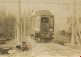
- The Burnaby Lake Line was constructed due to the advocacy of Burnaby residents and the Municipality of Burnaby to build the line. A petition was circulated by residents in 1907, and eventually substantial land bonuses were given to the company to induce them to build the line. Property owners in the area hoped the construction of the line would increase their land values. Construction of the 15-mile line was announced in 1909, and the line opened in 1911. The line travelled from Vancouver to New Westminister through central Burnaby.The last day of service was October 23, 1953. When the Trans Canada highway was constructed in the 1960s, it followed the right of way of the Burnaby Lake Line through Burnaby.
- Historic Neighbourhood
- Burnaby Lake (Historic Neighbourhood)
- Planning Study Area
- Burnaby Lake Area
