Narrow Results By
Decade
- 2020s 258
- 2010s
- 2000s 756
- 1990s 1075
- 1980s 1277
- 1970s 2064
- 1960s 1520
- 1950s 600
- 1940s 288
- 1930s 230
- 1920s 545
- 1910s 427
- 1900s 137
- 1890s 46
- 1880s 10
- 1870s 4
- 1860s
- 1850s 3
- 1840s 2
- 1830s 2
- 1820s 2
- 1810s 2
- 1800s 2
- 1790s 2
- 1780s 2
- 1770s 2
- 1760s 2
- 1750s 2
- 1740s 2
- 1730s 2
- 1720s 2
- 1710s 2
- 1700s 2
- 1690s 2
- 1680s 2
- 1670s 1
- 1660s 1
- 1650s 1
- 1640s 1
- 1630s 1
- 1620s 1
- 1610s 1
- 1600s 1
Subject
- Buildings 1
- Buildings - Commercial - Grocery Stores 1
- Buildings - Heritage 1
- Buildings - Industrial - Factories 1
- Buildings - Industrial - Saw Mills 2
- Buildings - Schools - Universities and Colleges 3
- Clothing 1
- Crafts 1
- Education 11
- Employment 2
- Environmental Issues 1
- Environmental Issues - Environmental Protection 1
Person / Organization
- Baker, Ronald J. "Ron" 2
- Barnet Mountain Park 1
- Barnet Rifle Club 2
- Belhouse, Jack 7
- Blaney, Jack 2
- Bolton, Richard 1
- Bossort, Kathy 37
- Burnaby Lake Park Association 1
- Burnaby Mountain Biking Association 3
- Burnaby Mountain Centennial Park 1
- Burnaby Mountain Centennial Rose Garden 1
- Burnaby Mountain Park 1
Interview with Lee Rankin by Kathy Bossort December 2, 2015 - Track 8
https://search.heritageburnaby.ca/link/oralhistory649
- Repository
- City of Burnaby Archives
- Date Range
- 1995-2015
- Length
- 0:11:13
- Summary
- This portion of the interview is about what the traditional landmark character of Burnaby Mountain means to Lee Rankin. He also talks about the future of the urban forest on Burnaby Mountain, and the legacy created for future generations by protecting the land as a park.
- Repository
- City of Burnaby Archives
- Summary
- This portion of the interview is about what the traditional landmark character of Burnaby Mountain means to Lee Rankin. He also talks about the future of the urban forest on Burnaby Mountain, and the legacy created for future generations by protecting the land as a park.
- Date Range
- 1995-2015
- Length
- 0:11:13
- Names
- Stanley Park
- Geographic Access
- Burnaby Mountain Conservation Area
- Interviewer
- Bossort, Kathy
- Interview Date
- December 2, 2015
- Scope and Content
- Recording is of an interview with Lee Rankin conducted by Kathy Bossort. Lee Rankin was one of 23 participants interviewed as part of the Community Heritage Commission’s Burnaby Mountain Oral History Project. The interview is mainly about Lee Rankin’s involvement in finding a resolution to the dispute between the City of Burnaby and Simon Fraser University over land ownership and control on Burnaby Mountain. He talks about the origin of the dispute, the positions taken by the two sides, the key people who brought about a resolution, and the main features of the agreement between the City, SFU and the province of BC. He talks about how the agreement met SFU’s goals, fostered trust between the City and university, and removed uncertainty from protecting parkland on Burnaby Mountain.
- Biographical Notes
- Lee Rankin was born in 1953 in Vancouver. He attended SFU 1973-78, completing his BA degree in 1985. He earned his law degree at UBC in 1988, was called to the Bar in 1989, and practiced in immigration and refugee law. Lee has lived in Burnaby since 1976 and was a member of Burnaby Council for 22 years, from 1983-1999 and 2002-2008. His particular interests as a Councillor were in community planning, housing and environment. Among other duties and accomplishments as Councillor, Lee served as chair of the Simon Fraser Liaison Committee and was involved in the negotiations with the province and SFU that resulted in the university returning more than 800 acres of land to the City, which was dedicated as part of the Burnaby Mountain Conservation Area. He has also served on the GVRD, volunteers as a coach for team sports in Burnaby, and has served on numerous community and business associations and committees. Lee is married to Ragini Venkat Rankin and has one son Henry.
- Total Tracks
- 8
- Total Length
- 1:50:35
- Interviewee Name
- Rankin, Lee A.
- Interview Location
- Lee Rankin's home in Burnaby
- Interviewer Bio
- Kathy Bossort is a retired archivist living in Ladner, BC. She worked at the Delta Museum and Archives after graduating from SLAIS (UBC) in 2001 with Masters degrees in library science and archival studies. Kathy grew up in Calgary, Alberta, and, prior to this career change, she lived in the West Kootenays, earning her living as a cook for BC tourist lodges and work camps. She continues to be interested in oral histories as a way to fill the gaps in the written record and bring richer meaning to history.
- Collection/Fonds
- Community Heritage Commission Special Projects fonds
- Media Type
- Sound Recording
Audio Tracks
Track eight of interview with Lee Rankin
Track eight of interview with Lee Rankin
https://search.heritageburnaby.ca/media/hpo/_Data/_Archives_Oral_Histories/_Unrestricted/MSS196-014/MSS196-014_Track_8.mp3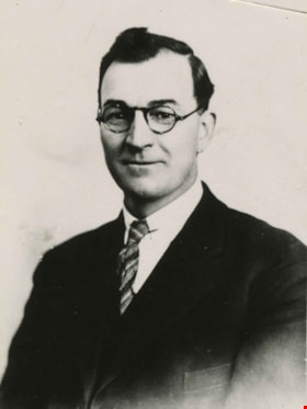
Open meeting with William Pritchard and Norman Penner July / August 1973 - Track 5
https://search.heritageburnaby.ca/link/oralhistory82
- Repository
- City of Burnaby Archives
- Date Range
- 1688-1919
- Length
- 0:08:51
- Summary
- This portion of the meeting pertains to William Pritchard's thoughts on Socialism and Revolution in their various incantations. He also discusses the political leanings of the arrested Winnipeg Strikers.
- Repository
- City of Burnaby Archives
- Summary
- This portion of the meeting pertains to William Pritchard's thoughts on Socialism and Revolution in their various incantations. He also discusses the political leanings of the arrested Winnipeg Strikers.
- Date Range
- 1688-1919
- Photo Info
- William A. Pritchard, Burnaby Reeve 1930-1932 and council member 1928-1930. Item no. 459-016
- Length
- 0:08:51
- Names
- Woodsworth, James Shaver
- Subjects
- Political Theories
- Interview Date
- July / August 1973
- Scope and Content
- Recording is of a open meeting with William Pritchard and writer Norman Penner. Norman Penner is the editor of the book "Winnipeg 1919" about the strike from the striker's perspective. William Pritchard wrote the speech that was included in the book. Audience members were invited to ask Pritchard questions. Major theme discussed is: The Winnipeg General Strike. To view "Narrow By" terms for each track expand this description and see "Notes".
- Biographical Notes
- William "Bill" Arthur Pritchard was born on April 3, 1888 in Salford, England, the son of a miner and factory worker. In May 1911, Bill moved to British Columbia and within a week of arriving became an active member of the Socialist Party of Canada. From 1914 to 1917, he served as editor of the Western Clarion – the SPC newspaper. He became such a well-known socialist figure that when he travelled to Winnipeg to participate in the General Strike in 1919, he was one of only seven people arrested and imprisoned for his participation in the event despite the fact that he was in no way directly involved in its planning nor development. In 1922, Bill and his family settled in North Burnaby in the Capitol Hill District. Almost immediately after his arrival, Bill began to advocate for change and a planned development scheme for the municipality. Pritchard ran successfully for the position of Reeve and held the post until the end of 1932. One of Reeve Pritchard’s highest priorities while in office was to attempt to provide work for as many unemployed as possible all the while trying to elicit more support from the provincial and federal governments. Bill was a strong advocate of the belief that relief work should be focused on projects that would see a comprehensive development scheme for Burnaby – including planned sewers, roads and water supply. Despite Bill's best efforts, however, Burnaby was forced into receivership and at the end of 1932, a Provincial Commission stepped in to take over the governance of the city. Reeve Pritchard, having done all he could as a champion of the unemployed, stepped down as Reeve but left behind an undeniable legacy of courage and determination. He was rewarded for his enormous contributions to the city in 1975 when he was chosen to be made a Freeman of Burnaby. William Pritchard died on October 23, 1981. Norman Penner was born in Winnipeg in 1921 to Rose and Jacob Penner and brother to Roland, Ruth and Walter. Their father Jacob was a leading member of the Communist Party and popular Winnipeg Alderman. Norman graduated from high school in 1937 but did not begin university until much later, preferring to begin his adult life from 1938 to 1941 as a full-time officer of the Winnipeg branch of the Communist Party of Canada. From 1941 to 1946 he served with the Canadian Army which included two-and-a-half years of overseas combat duty. On his return to Canada in 1947 he again returned to his duties as a full-time officer with the communist Labour-Progressive Party (formed in 1941 after the Canadian Communist Party was officially banned). After the abortive Hungarian revolution in 1956, Norman Penner resigned from the party and instead worked as a self-employed manufacturer’s sales representative until 1971. In 1964 he decided to go back to school part time and graduated with a BA from the University of Toronto in 1969. He took an MA in 1971 and a PhD in 1975 from the same institution. Penner was hired as a lecturer at York University's Glendon College in 1972 and soon became a professor, continuing to teach until 1995. He wrote extensively on the Canadian left. Penner edited and introduced "Winnipeg 1919: The Strikers' Own History of the Winnipeg General Strike" in 1973, published "The Canadian Left: A Critical Analysis" in 1977 and contributed three chapters to as well as editing "Keeping Canada Together Means Changing Our Thinking" in 1978. He published "Canadian Communism: The Stalin Years and Beyond" in 1988 and "From Protest to Power: Social Democracy in Canada 1900 to Present" in 1992 as well as numerous articles, reviews and book chapters. Norman Penner was married to Norma Lipes for sixty-seven years. The couple had four children: Steve (Mary Ellen Marus); Joyce (Herman Parsons); Gary (Marlene Kadar); and Bob (Shaena Lambert). Norman Penner died April 16, 2009 at the age of eighty-eight.
- Total Tracks
- 7
- Total Length
- 1:03:00
- Interviewee Name
- Pritchard, William A.
- Penner, Norman
- Collection/Fonds
- Burnaby Historical Society fonds
- Subseries
- Oral history subseries
- Media Type
- Sound Recording
- Web Notes
- Interview was digitized in 2010 allowing it to be accessible on Heritage Burnaby. The digitization project was initiated by the Community Heritage Commission with support from City of Burnaby Council and the BC History Digitization Program of the Irving K. Barber Learning Centre, University of British Columbia. It was recognized by the Heritage Society of BC with an award in 2012.
Images

Audio Tracks
Track five of open meeting with William Pritchard and Norman Penner
Track five of open meeting with William Pritchard and Norman Penner
https://search.heritageburnaby.ca/media/hpo/_Data/_Archives_Oral_Histories/_Unrestricted/100-13-02-2/100-13-02-2_Track_5.mp3Strata Title Properties series
https://search.heritageburnaby.ca/link/archivedescription185
- Repository
- City of Burnaby Archives
- Date
- 1990-2014
- Collection/Fonds
- Planning Department fonds
- Description Level
- Series
- Scope and Content
- Series consists of those records created during the Strata Title application and approval process and includes: application forms, maps, plans, technical and architectural drawings, reports and recommendations from a wide range of City departments, right-of-way agreements, approval checklists, rece…
- Repository
- City of Burnaby Archives
- Date
- 1990-2014
- Collection/Fonds
- Planning Department fonds
- Description Level
- Series
- Scope and Content
- Series consists of those records created during the Strata Title application and approval process and includes: application forms, maps, plans, technical and architectural drawings, reports and recommendations from a wide range of City departments, right-of-way agreements, approval checklists, receipts, and correspondence.
- Media Type
- Textual Record
Subdivision Control series
https://search.heritageburnaby.ca/link/archivedescription187
- Repository
- City of Burnaby Archives
- Date
- 1940-2015
- Collection/Fonds
- Planning Department fonds
- Description Level
- Series
- Scope and Content
- Series consists of the records created during the subdivision application process. This includes the initial application made by the property owner(s), the relevant reports and recommendations by outside departments and agencies, inter- and extra-office communication and correspondence, receipts o…
- Repository
- City of Burnaby Archives
- Date
- 1940-2015
- Collection/Fonds
- Planning Department fonds
- Series
- Subdivision Control series
- Description Level
- Series
- Scope and Content
- Series consists of the records created during the subdivision application process. This includes the initial application made by the property owner(s), the relevant reports and recommendations by outside departments and agencies, inter- and extra-office communication and correspondence, receipts of fees paid, maps, plans, architectural drawings, tentative approval checklists, right-of-way agreements, easements, covenants, road closure references, Title Search Certificates, and final approval checklists.
- Media Type
- Textual Record
UniverCity on Burnaby Mountain
https://search.heritageburnaby.ca/link/archivedescription71900
- Repository
- City of Burnaby Archives
- Date
- 2010
- Collection/Fonds
- Planning Department fonds
- Description Level
- Item
- Physical Description
- Textual record
- Scope and Content
- Folder contains a report on the development "UniverCity" on Burnaby Mountain.
- Repository
- City of Burnaby Archives
- Date
- 2010
- Collection/Fonds
- Planning Department fonds
- Physical Description
- Textual record
- Description Level
- Item
- Record No.
- 46222
- Accession Number
- 2012-15
- Scope and Content
- Folder contains a report on the development "UniverCity" on Burnaby Mountain.
- Media Type
- Textual Record
- Notes
- Transcribed title
![Survey and Subdivision plans in New Westminster District Group 1 – Burnaby
, [1861]-[1910] thumbnail](/media/hpo/_Data/_BVM_Cartographic_Material/1977/1977_0093_0019a_001.jpg?width=280)
Survey and Subdivision plans in New Westminster District Group 1 – Burnaby
https://search.heritageburnaby.ca/link/museumdescription6988
- Repository
- Burnaby Village Museum
- Date
- [1861]-[1910]
- Collection/Fonds
- Burnaby Village Museum Map collection
- Description Level
- File
- Physical Description
- 14 plans : 3 plans : black ink on paper hand col. + 7 plans : black ink on paper + 4 plans : graphite on paper mounted on 2 sides of cardboard 76 x 102 cm
- Scope and Content
- Item consists of a large board of four New Westminster District Gp 1 - subdivision plans mounted on one side and ten New Westminster District Gp 1 - subdivision plans mounted on the other side. Side A: 1. "Plan /of / Lots 166A, 166 and 167 /, Gr.1, N.W.D. / Showing Misconstructed Roads in Gree…
- Repository
- Burnaby Village Museum
- Collection/Fonds
- Burnaby Village Museum Map collection
- Description Level
- File
- Physical Description
- 14 plans : 3 plans : black ink on paper hand col. + 7 plans : black ink on paper + 4 plans : graphite on paper mounted on 2 sides of cardboard 76 x 102 cm
- Material Details
- Scales [between 1:2376 and 1:7920]
- Index number on edge of board reads: "19"
- Scope and Content
- Item consists of a large board of four New Westminster District Gp 1 - subdivision plans mounted on one side and ten New Westminster District Gp 1 - subdivision plans mounted on the other side. Side A: 1. "Plan /of / Lots 166A, 166 and 167 /, Gr.1, N.W.D. / Showing Misconstructed Roads in Green / 5 chs = 1 in.". (plan is drawn in black ink and hand coloured in red, green and orange ink). A section in the centre of the plan is coloured in red ink and identified as "C.S. Richmond" running from the North Arm of Fraser River to Wiggins Road and divided by "New Wiggins Rd. (as gazetted)" (coloured in orange ink) and two"Constructed Road(s)" (coloured in green ink). Plan is initialed by: "RB" [sic] (in blue pencil crayon) 2. Plan of / Subdivision of / Lot 166 / Group One / New Westminster District / Scale 4 chs = 1 in. / Map No 524". Plan is drawn in graphite and signed by "Surrig [sic] Welhams [sic] / P.L.S." Plan is initialed by: "RB" [sic] (in blue pencil crayon) 3. Plan of "Survey / of Highway / For / Burnaby Council / in / Lots 13 _14 / Group One / Scale 4 chs = 1 in." Signed by "Albert J. Hill, P.L.S." Caribou Street and Caribou Road run through the centre of the plan. Plan is stamped: "Albert J. Hill, Civil Engineer / and / Provincial Land Surveyor, / New Westminster, / B.C.". Plan is initialed by: "RB" [sic] (in blue pencil crayon) 4. A Plan of Lots 166A, 166 and 167, Group One, New Westminster District (drawn in graphite). A section in the centre of the plan is identified as "C.S. Richmond" running from the North Arm of Fraser River and divided by "New Wiggins Rd. (as gazetted)" and two "Constructed Road(s)". Plan is initialed by: "RB" [sic] (in blue pencil crayon) Side B: 1. Small plan drawn in black ink (no title) identifying lots north of the "North Arm" of the Fraser River. Lots identified include: Lot 99, Lot 98, Lot 157, Lot 158, Lot 163, Lot 162, Lot 159, Lot 163, Lot 162, Lot 165, Lot 166A, Lot 155B, Lot 155A and Lot 159. "Scale 40 chains to one inch" . Plan is initialed by: "RB" [sic] (in blue pencil crayon) (Geographic location: Burnaby) 2. Small plan drawn in black ink (no title) identifying lots north of the North Arm of the Fraser River as "Lots 155, 155A, 155B, 155C, 162, 163, 164, 165, 166A and 167". Plan is initialed by: "RB" [sic] (in blue pencil crayon) (Geographic location: Burnaby) 3. Small plan drawn in black ink (no title) which identifies "Lot 151 / Reserve/ for / Race Course"; "Reserve / 64 A / L. 152 G.1"; and other Lots: 32, 33, 34, 35, 36, 38, 39. The plan is signed "Surveyor G.Turn [sic] July / 61 / from Vol 40 R.L. notes [sic]" Plan is stamped: "Albert J. Hill, Civil Engineer / and / Provincial Land Surveyor, / New Westminster, / B.C." Plan is initialed by: "RB" [sic] (in blue pencil crayon) (Geographic location: Burnaby) 4. Small plan drawn in black in with faded red colouring on centre lot identified as "Lot 34" running north from "Vancouver Road" . Plan is stamped: "Albert J. Hill, Civil Engineer / and / Provincial Land Surveyor, / New Westminster, / B.C." Plan is initialed by: "RB" [sic] (in blue pencil crayon) (Geographic location: Burnaby) 5. Plan drawn in graphite and identified as "Lot 98, Gr.1," along with the intials "RB" [sic] (both are handwritten in blue crayon pencil on top of plan) The B.C.E.Railway is identified running through the plan along with Jubilee Road and Royal Oak Road. The plan is signed with the name "Wm. Murray" and the Plan is stamped: "Albert J. Hill, Civil Engineer / and / Provincial Land Surveyor, / New Westminster, / B.C.". (Geographic location: Burnaby) 6. Plan drawn in graphite identified as "Port Lot 13, Gr.1" along with the intials "RB" [sic] (both are handwritten in blue crayon pencil on top of plan) Plan is stamped: "Albert J. Hill, Civil Engineer / and / Provincial Land Surveyor, / New Westminster, / B.C.". (Geographic location: Burnaby) 7.Plan drawn in black ink and identified as "Lot 98 G.1" along with the intials "RB" [sic] (both are handwritten in blue crayon pencil on top of plan). A "Road Reservation" is identified running north between "Electric Tramway" and connecting with "Royal Oak Road". Plan is stamped: "Albert J. Hill, Civil Engineer / and / Provincial Land Surveyor, / New Westminster, / B.C." (Geographic location: Burnaby) 8. Plan drawn in black ink and divided into two sections, the upper plan is identified as "Portion / Lots 100 / area / 101, Gr.1" and the lower plan is identified as "Portion L. 3 G. 1" along with the intials "RB" [sic] (these identifiers are handwritten in blue crayon pencil on top of the plan). Portions of Lot 100 and Lot 101 are each divided into 6 sections and the Portion of Lot 3 plan is divided into 24 sections. The plan includes a note in black ink that reads: " Received from Wm Fromme [sic] / from Wm. Trapp / Nov. 28, 1895 / A. J. T...[sic]". (Geographic location: Burnaby) 9. Plan drawn in black ink (no title) identifying soil, buildings and geographic features in southern Burnaby. The plan is bordered by "New Westminster City" (Tenth Avenue and DL 172) to the south east and DL 173 to the south, DL 158 to the west and the B.C.E. Tramway to the north. Plan includes District Lots: 155A, 158, 159, 171, 160, 53 and 95 and identifies soil, marshland and ravines throughout. Plan identifies the following features: a "Team Road" running through Lots 158 and 159 along with "Fair Orchard Soil / Even Surface Throughout / No Ravines", "Gravel and Shingle" (bottom of Lot 158), "North Arm Road" crossing "Byrne Road" and connecting with "Power House Road" which runs north to connect with "Highland Park Station" and the B.C.E. Tramway, "Power Ho" in the northeast corner of DL 160, a "Brook" connected with a "Deep Ravine" running between DL 53, DL 95 and DL 160 along with "Good Soil" and "Fair Orchard Soil" identified nearby in DL 95. Scale is identified as "10 chs = 1 in." Plan is stamped: "Albert J. Hill, Civil Engineer / and / Provincial Land Surveyor, / New Westminster, / B.C." Plan is initialed by: "RB" [sic] (in blue pencil crayon) (Geographic location: Burnaby) 10. Plan drawn in black ink (no title) with Burnaby Lake and Deer Lake at the centre. The plan is bordered by the following District Lots identified as: 117, 118 and 68 to the west, Lots 80, 79 and 85 to the southwest, Lots 11, 13, and 1 (City of New Westminster) to the south east, the North Road boundary to the east and Lots 8, 56, 57, 59, and 136 to the North. The lower right hand corner of the plan has a small inset which reads: "Burnaby Lake" and "Page 19 R.B. Notes". Plan is initialed by: "RB" [sic] (in blue pencil crayon) (Geographic location: Burnaby)
- Creator
- Hill, Albert James
- Accession Code
- HV977.93.19
- Access Restriction
- No restrictions
- Reproduction Restriction
- No known restrictions
- Date
- [1861]-[1910]
- Media Type
- Cartographic Material
- Scan Resolution
- 300
- Scale
- 72
- Notes
- Title based on contents of file
- Scale is measured in chains. (One chain equals 792 inches)
- The term "Lot" can also refer to a "District Lot”
- Some plans are stamped: "Albert J. Hill, Civil Engineer / and / Provincial Land Surveyor, / New Westminster, / B.C." and intialed: "RB" [sic]
Images
![Survey and Subdivision plans in New Westminster District Group 1 – Burnaby
, [1861]-[1910] thumbnail](/media/hpo/_Data/_BVM_Cartographic_Material/1977/1977_0093_0019a_001.jpg)

![Survey and Subdivision plans in New Westminster District Group 1 – Burnaby, Port Moody, [1862-1908] thumbnail](/media/hpo/_Data/_BVM_Cartographic_Material/1977/1977_0093_0026a_001.jpg?width=280)
Survey and Subdivision plans in New Westminster District Group 1 – Burnaby, Port Moody
https://search.heritageburnaby.ca/link/museumdescription6995
- Repository
- Burnaby Village Museum
- Date
- [1862-1908]
- Collection/Fonds
- Burnaby Village Museum Map collection
- Description Level
- File
- Physical Description
- 9 plans : 6 plans : black ink on paper ; 57 x 36.5 cm or smaller + 1 plan : black ink and grahite on paper ; 46.5 x 49 cm + 1 plan : blueprint on paper ; 15.5 x 19.5 cm + cm + 1 plan : graphite on paper ; 25 x 17 cm ; mounted on both sides of board 76 x 102 cm
- Scope and Content
- Item consists of a large board of four New Westminster District subdivision plans mounted on one side and five New Westminster District subdivision plans mounted on the other side. Side A: 1. "Plan / of Subdivision / of a Portion / of / Lot 87 / Group One / New Westminster District / Scale 4 chs…
- Repository
- Burnaby Village Museum
- Collection/Fonds
- Burnaby Village Museum Map collection
- Description Level
- File
- Physical Description
- 9 plans : 6 plans : black ink on paper ; 57 x 36.5 cm or smaller + 1 plan : black ink and grahite on paper ; 46.5 x 49 cm + 1 plan : blueprint on paper ; 15.5 x 19.5 cm + cm + 1 plan : graphite on paper ; 25 x 17 cm ; mounted on both sides of board 76 x 102 cm
- Material Details
- Scales [between 1:792 and 1:3600]
- Index number on edge of board reads: "26"
- Scope and Content
- Item consists of a large board of four New Westminster District subdivision plans mounted on one side and five New Westminster District subdivision plans mounted on the other side. Side A: 1. "Plan / of Subdivision / of a Portion / of / Lot 87 / Group One / New Westminster District / Scale 4 chs = 1 in". Plan is stamped: "Albert J. Hill, Civil Engineer / and / Provincial Land Surveyor, / New Westminster, / B.C." and intialed by: "RB" [sic] (in blue pencil crayon). Names two of the subdivisons of District Lot 87 are identified as, "L.E. Sprott" and "John Ledger". (Geographic location: Burnaby) 2. "Plan of Subdivision / of / Portions of / Lot 136, 131 and Lots 44 and 78 Gr.1 / New Westminster District / Scale 300 ft = 1 inch". Annotation above title reads: "No. 901 / Deposited in Land Registry Office / New Westminster / Aug. 19th 1905 / Charles S. Keith D. Reg." Annotations and signatures at bottom of plan read: "I, William Nelson Draper, / W.H.R. Collister / Charles E. Perkins / E.B. Morgan / make / Surveys / correct / representation / upon / the / Land Registry Act / (sgd) W.N. Draper, P.L.S.". Plan includes a handwritten title: "Lots 136, 131, 44 & 78" and is initialed: "RB" [sic] (in blue pencil crayon) (Geographic location: Burnaby) 3. "Survey / of / a Portion / of / Lot 95, Gr.1 / Scale 1 ch = 1in." Plan is stamped: "Albert J. Hill, Civil Engineer / and / Provincial Land Surveyor, / New Westminster, / B.C." and is initialed : "RB" [sic] (in blue pencil crayon) (Geographic location: Burnaby) 4. Blueprint plan of "Lot 396. Group One." with Scale : 3 chs = 1 in. A two acre portion of District Lot 396 is filled in with red ink." Plan is signed by "Albert J. Hill / B.C.L.S." (Geographic location: Port Moody) Side B: 1. Plan titled "District Lot 92 / Burnaby / Municipality / for sale by / Mahon / McFarland & / Mahon Ltd. / Vancouver, B.C. / Scale : 4 chains to one inch". District Lot 92 is subdivided into 161 lots and identifies roads: Norwich Road, Pole Line Road, Oakland Road, Stanley Road, Burford Road, Dalhousie Road, Brantford Road, Colborne Road, Roberts Road, Vancouver & Westminster Road, B.C. Electric Railway, Gilley Stn. and Burnaby (Power House). The bottom of the plan reads: "G.S. Dawson, P.LS. Vancouver, B.C." (Geographic location: Burnaby) 2. "Plan / of Subdivision / of a Portion / of / Lot 29 / Group 1 / New Westminster District / Scale 2 chs = 1 in". Plan is stamped: "Albert J. Hill, Civil Engineer / and / Provincial Land Surveyor, / New Westminster, / B.C." and is initialed by: "RB" [sic] (in blue pencil crayon) (Geographic location: Burnaby) 3. Small handrawn plan (no title) identifying "Lot 84 / Hydes, Claim" at the centre surrounded by lots and features identified as: "Lot 85", "Lot 93", "Lot 94", "Lot 32", "Lot 82", "Lot 83", "Lot 79", "swamp" and a "Small Lake" (Burnaby Lake). Identifying marks in the right corner of the plan read: "Page 13 / Surveyed by G. Turner / May 62". Plan also includes surveyor's bearing measurements and trails to "Small Lake" (Burnaby Lake). (Geographic location: Burnaby) 4. Untitled plan showing District Lots west of North Road and north of Burnaby Lake including: Lots 2, 4, 6, 8, 15, 10, 56, 148, 57, 58, 40. and Lots 3, 5, 7 east of North Road (Coquitlam). Lots in Burnaby are identifed for timber including: "Heavily Timbered" (Lot 57), " "Some Fir and Cedar" (Lot 40), "Splendid Fir and Cedar" (Lot 143), "Heavy Fir etc" (Lots 143 and 148), " "Fine Cedar" (Lot 15), "Rough Light Timber" (Lot 56). Other features identified at the lower portion of the plan include "Burnaby Lake" and "Brunette River". (Geographic location: Burnaby) 5. Untitled plan drawn in graphite showing sections of District Lot 85 south of Burnaby Lake and north of Hazsard Road. Plan is signed: "Albert J. Hill / B.C.L.S." and dated "12/26/08". Plan is initialed by: "RB" [sic] (in blue pencil crayon) (Geographic location: Burnaby)
- Publisher
- Mahon, McFarland & Mahon Ltd
- Accession Code
- HV977.93.26
- Access Restriction
- No restrictions
- Reproduction Restriction
- No known restrictions
- Date
- [1862-1908]
- Media Type
- Cartographic Material
- Historic Neighbourhood
- Burnaby Lake (Historic Neighbourhood)
- Burquitlam (Historic Neighbourhood)
- Planning Study Area
- Burnaby Lake Area
- Scan Resolution
- 300
- Scale
- 72
- Notes
- Title based on contents of file
- Scale is measured in chains and feet. (One chain equals 792 inches)
- The term "Lot" can also refer to a "District Lot”
Images
![Survey and Subdivision plans in New Westminster District Group 1 – Burnaby, Port Moody, [1862-1908] thumbnail](/media/hpo/_Data/_BVM_Cartographic_Material/1977/1977_0093_0026a_001.jpg)


![BFG bag prop concept plan, [2015] thumbnail](/media/hpo/_Data/_BVM_Images/2022/2022_0021_0100_001.jpg?width=280)
BFG bag prop concept plan
https://search.heritageburnaby.ca/link/museumdescription19155
- Repository
- Burnaby Village Museum
- Date
- [2015]
- Collection/Fonds
- Hipman "Jimmy" Chow and Donna Polos fonds
- Description Level
- Item
- Physical Description
- 1 photograph : col. laser print ; 28 x 43.5 cm with annotations
- Scope and Content
- Item consists of a concept plan created by concept illustrator Brian Cunningham for a leather bag to be used as a prop in the film "The BFG". Ovelay of tape with actual measurements on surface of print for the creation of the leather bag. Concept plan was used by property master, Jimmy Chow to crea…
- Repository
- Burnaby Village Museum
- Collection/Fonds
- Hipman "Jimmy" Chow and Donna Polos fonds
- Description Level
- Item
- Physical Description
- 1 photograph : col. laser print ; 28 x 43.5 cm with annotations
- Material Details
- Green masking tape and white duct tape adhered to surface of print
- Handwritten measurements in black ink written on surface of tape
- Scope and Content
- Item consists of a concept plan created by concept illustrator Brian Cunningham for a leather bag to be used as a prop in the film "The BFG". Ovelay of tape with actual measurements on surface of print for the creation of the leather bag. Concept plan was used by property master, Jimmy Chow to create the bag as a prop. The film was directed by Steven Spielberg and released in 2016.
- Creator
- Cunningham, Brian
- Subjects
- Industries - Film
- Responsibility
- Beach, Chris
- Accession Code
- BV022.21.100
- Access Restriction
- No restrictions
- Reproduction Restriction
- May be restricted by third party rights
- Date
- [2015]
- Media Type
- Graphic Material
- Notes
- Title based on contents of item
- Bottom right corner includes identifiers reading: "? / ...BFG 3 BAG_PROP CONCEPT / ... PROP BFG BAG CONCEPT / .../ Scale / 15:00:00 [sic] / ? / C_BEACH /? / B_CUNNINGHAM / ? / NONE [sic] / ? / PRP_C05 / ..."
- Drawing identifies, Brian Cunningham as concept illustrator and Chris Beach as [designer] (Art Director)
Images
![BFG bag prop concept plan, [2015] thumbnail](/media/hpo/_Data/_BVM_Images/2022/2022_0021_0100_001.jpg)
House Demolition - Lot 18, DL 153, EXC. Plan Parcel C, Expl. Plan 11380, Plan 2884 (Metrotown Sub-Area 7, Maywood) 6392 McKay Avenue
https://search.heritageburnaby.ca/link/councilreport59014
- Repository
- City of Burnaby Archives
- Report ID
- 92229
- Meeting Date
- 17-Jun-2013
- Format
- Council - Manager's Report
- Item No.
- 2
- Collection/Fonds
- City Council and Office of the City Clerk fonds
- Repository
- City of Burnaby Archives
- Report ID
- 92229
- Meeting Date
- 17-Jun-2013
- Format
- Council - Manager's Report
- Item No.
- 2
- Collection/Fonds
- City Council and Office of the City Clerk fonds
Documents
Metrotown Downtown Plan Phase II Consultation and Finalized Plan
https://search.heritageburnaby.ca/link/councilreport80719
- Repository
- City of Burnaby Archives
- Report ID
- 101617
- Meeting Date
- 24-Jul-2017
- Format
- Council - Manager's Report
- Item No.
- 1
- Collection/Fonds
- City Council and Office of the City Clerk fonds
- Repository
- City of Burnaby Archives
- Report ID
- 101617
- Meeting Date
- 24-Jul-2017
- Format
- Council - Manager's Report
- Item No.
- 1
- Collection/Fonds
- City Council and Office of the City Clerk fonds
Documents
2010-2014 Annual Financial Plan
https://search.heritageburnaby.ca/link/councilreport57315
- Repository
- City of Burnaby Archives
- Report ID
- 78126
- Meeting Date
- 3-May-2010
- Format
- Council - Manager's Report
- Item No.
- 1
- Collection/Fonds
- City Council and Office of the City Clerk fonds
- Repository
- City of Burnaby Archives
- Report ID
- 78126
- Meeting Date
- 3-May-2010
- Format
- Council - Manager's Report
- Item No.
- 1
- Collection/Fonds
- City Council and Office of the City Clerk fonds
Documents
2010-2014 Provisional Financial Plan
https://search.heritageburnaby.ca/link/councilreport57150
- Repository
- City of Burnaby Archives
- Report ID
- 77961
- Meeting Date
- 18-Jan-2010
- Format
- Council - Manager's Report
- Item No.
- 1
- Collection/Fonds
- City Council and Office of the City Clerk fonds
- Repository
- City of Burnaby Archives
- Report ID
- 77961
- Meeting Date
- 18-Jan-2010
- Format
- Council - Manager's Report
- Item No.
- 1
- Collection/Fonds
- City Council and Office of the City Clerk fonds
Documents
2011-2015 Annual Financial Plan
https://search.heritageburnaby.ca/link/councilreport57780
- Repository
- City of Burnaby Archives
- Report ID
- 78961
- Meeting Date
- 5-May-2011
- Format
- Council - Manager's Report
- Item No.
- 1
- Collection/Fonds
- City Council and Office of the City Clerk fonds
- Repository
- City of Burnaby Archives
- Report ID
- 78961
- Meeting Date
- 5-May-2011
- Format
- Council - Manager's Report
- Item No.
- 1
- Collection/Fonds
- City Council and Office of the City Clerk fonds
Documents
2011-2015 Provisional Financial Plan
https://search.heritageburnaby.ca/link/councilreport57601
- Repository
- City of Burnaby Archives
- Report ID
- 78783
- Meeting Date
- 13-Dec-2010
- Format
- Council - Manager's Report
- Item No.
- 1
- Collection/Fonds
- City Council and Office of the City Clerk fonds
- Repository
- City of Burnaby Archives
- Report ID
- 78783
- Meeting Date
- 13-Dec-2010
- Format
- Council - Manager's Report
- Item No.
- 1
- Collection/Fonds
- City Council and Office of the City Clerk fonds
Documents
2012 Provisional Financial Plan
https://search.heritageburnaby.ca/link/councilreport58143
- Repository
- City of Burnaby Archives
- Report ID
- 90266
- Meeting Date
- 12-Dec-2011
- Format
- Council - Committee Report
- Collection/Fonds
- City Council and Office of the City Clerk fonds
- Repository
- City of Burnaby Archives
- Report ID
- 90266
- Meeting Date
- 12-Dec-2011
- Format
- Council - Committee Report
- Collection/Fonds
- City Council and Office of the City Clerk fonds
Documents
The 2013 Annual Financial Plan
https://search.heritageburnaby.ca/link/councilreport58921
- Repository
- City of Burnaby Archives
- Report ID
- 92140
- Meeting Date
- 6-May-2013
- Format
- Council - Committee Report
- Collection/Fonds
- City Council and Office of the City Clerk fonds
- Repository
- City of Burnaby Archives
- Report ID
- 92140
- Meeting Date
- 6-May-2013
- Format
- Council - Committee Report
- Collection/Fonds
- City Council and Office of the City Clerk fonds
Documents
2014 Provisional Financial Plan
https://search.heritageburnaby.ca/link/councilreport59257
- Repository
- City of Burnaby Archives
- Report ID
- 99200
- Meeting Date
- 9-Dec-2013
- Format
- Council - Manager's Report
- Item No.
- 6
- Collection/Fonds
- City Council and Office of the City Clerk fonds
- Repository
- City of Burnaby Archives
- Report ID
- 99200
- Meeting Date
- 9-Dec-2013
- Format
- Council - Manager's Report
- Item No.
- 6
- Collection/Fonds
- City Council and Office of the City Clerk fonds
Documents
2015 Provisional Financial Plan
https://search.heritageburnaby.ca/link/councilreport59808
- Repository
- City of Burnaby Archives
- Report ID
- 99750
- Meeting Date
- 2-Feb-2015
- Format
- Council - Committee Report
- Collection/Fonds
- City Council and Office of the City Clerk fonds
- Repository
- City of Burnaby Archives
- Report ID
- 99750
- Meeting Date
- 2-Feb-2015
- Format
- Council - Committee Report
- Collection/Fonds
- City Council and Office of the City Clerk fonds
Documents
2016 - 2020 Provisional Financial Plan
https://search.heritageburnaby.ca/link/councilreport60506
- Repository
- City of Burnaby Archives
- Report ID
- 100813
- Meeting Date
- 14-Dec-2015
- Format
- Council - Committee Report
- Collection/Fonds
- City Council and Office of the City Clerk fonds
- Repository
- City of Burnaby Archives
- Report ID
- 100813
- Meeting Date
- 14-Dec-2015
- Format
- Council - Committee Report
- Collection/Fonds
- City Council and Office of the City Clerk fonds
Documents
2017 - 2021 Provisional Financial Plan
https://search.heritageburnaby.ca/link/councilreport71116
- Repository
- City of Burnaby Archives
- Report ID
- 101437
- Meeting Date
- 27-Feb-2017
- Format
- Council - Committee Report
- Collection/Fonds
- City Council and Office of the City Clerk fonds
- Repository
- City of Burnaby Archives
- Report ID
- 101437
- Meeting Date
- 27-Feb-2017
- Format
- Council - Committee Report
- Collection/Fonds
- City Council and Office of the City Clerk fonds