Narrow Results By
Decade
- 2020s
- 2010s 152
- 2000s 1828
- 1990s 2875
- 1980s 1366
- 1970s 3518
- 1960s 1359
- 1950s 1712
- 1940s 2148
- 1930s 2158
- 1920s 2489
- 1910s 2036
- 1900s 870
- 1890s
- 1880s 165
- 1870s 72
- 1860s 123
- 1850s 14
- 1840s
- 1830s 3
- 1820s 2
- 1810s 3
- 1800s 3
- 1790s 2
- 1780s 2
- 1770s 2
- 1760s 2
- 1750s 2
- 1740s 2
- 1730s 2
- 1720s 2
- 1710s 2
- 1700s 2
- 1690s 2
- 1680s 2
- 1670s 1
- 1660s 1
- 1650s 1
- 1640s 1
- 1630s 1
- 1620s 1
- 1610s 1
- 1600s 1
- 1590s 1
- 1580s 1
- 1570s 1
- 1560s 1
- 1550s 1
- 1540s 1
- 1530s 1
- 1520s 2
- 1510s 1
- 1500s 1
- 1490s 1
- 1480s 1
Subject
- Adornment - Jewelry 2
- Advertising Medium - Poster 1
- Advertising Medium - Signs and Signboards 59
- Agricultural Tools and Equipment 1
- Agriculture 6
- Agriculture - Crops 1
- Agriculture - Farms 12
- Agriculture - Fruit and Berries 5
- Agriculture - Ranches 1
- Animals - Birds 1
- Animals - Dogs 4
- Animals - Fish 1

Barnet Neighbourhood
https://search.heritageburnaby.ca/link/landmark716
- Repository
- Burnaby Heritage Planning
- Associated Dates
- 1889-1904
- Heritage Value
- The North Pacific Lumber Company in Barnet was one of Burnaby's first industrial developments and one of the largest in the British Empire. Partners James MacLaren and Frank Ross built the mill in 1889 (activated in 1899) as a requirement for obtaining 84,000 acres of timber rights in northern BC. Due to the mill's isolation, the firm built homes for its employees with families and bunkhouses for the bachelors which separated Caucasian workers from Chinese and Sikh workers. Barnet became a distinct company town with its own general store, school, post office, community hall and telephone exchange.
- Historic Neighbourhood
- Barnet (Historic Neighbourhood)
- Planning Study Area
- Burnaby Mountain Area
Images


Barnet School
https://search.heritageburnaby.ca/link/landmark719
- Repository
- Burnaby Heritage Planning
- Geographic Access
- Barnet Road
- Associated Dates
- 1899
- Heritage Value
- When the Barnet Mill began operations in 1899, the mill authorities opened a small school to accommodate the children of employees. The school was located in a remodelled harness-room beside the mill and Miss Phoebe Spragge was the first teacher at a salary of $40.00 per month. By 1907, the school had been moved to a purpose-built building where it remained in operation until the early 1950s.
- Historic Neighbourhood
- Barnet (Historic Neighbourhood)
- Planning Study Area
- Burnaby Mountain Area
- Street Address
- 7820 Barnet Road
Images


Burnaby Municipal Hall
https://search.heritageburnaby.ca/link/landmark730
- Repository
- Burnaby Heritage Planning
- Geographic Access
- Kingsway
- Associated Dates
- 1899
- Heritage Value
- Although Burnaby was incorporated as a municipality in 1892, its first Municipal Hall was not built until 1899 and located at Kingsway and Edmonds. It was close to the tram line on Kingsway and at the population centre of South Burnaby.
- Historic Neighbourhood
- Edmonds (Historic Neighbourhood)
- Planning Study Area
- Stride Avenue Area
- Street Address
- 7252 Kingsway
- Street View URL
- Google Maps Street View
Images


Central Park
https://search.heritageburnaby.ca/link/landmark728
- Repository
- Burnaby Heritage Planning
- Geographic Access
- Imperial Street
- Associated Dates
- 1891
- Heritage Value
- In 1860, as the Royal Engineers constructed the road from New Westminster to Vancouver (now Kingsway), a military reserve was set aside at the trail's highest point along the ridge. This reserve provided a particularly good scenic look-out since the original forest had burned down prior to 1860, the remaining stumps offered unobstructed views. By the 1880s, the city council of both New Westminster and Vancouver eyed the reserve as potential recreation ground. As construction of the tram line was underway, the Provincial Government moved to designate the whole reserve as a park. On January 14, 1891, the Lieutenant Governor of British Columbia proclaimed it as a public recreation ground.
- Historic Neighbourhood
- Central Park (Historic Neighbourhood)
- Planning Study Area
- Maywood Area
- Street Address
- 3883 Imperial Street
- Street View URL
- Google Maps Street View
Images


Central Park Neighbourhood
https://search.heritageburnaby.ca/link/landmark723
- Repository
- Burnaby Heritage Planning
- Associated Dates
- 1891-1904
- Heritage Value
- Central Park was one of the first and fastest-growing communities in Burnaby. Located along the electric tram line and the Vancouver Road (Kingsway), it was also chosen for a government settlement project referred to as the Central Park Small Holdings. The lands held by the Provincial Government were subdivided and sold around 1894 and by 1899 the settlement was large enough to warrant the construction of an Anglican Church there.
- Historic Neighbourhood
- Central Park (Historic Neighbourhood)
- Planning Study Area
- Maywood Area
Images


Central Park Tramline
https://search.heritageburnaby.ca/link/landmark732
- Repository
- Burnaby Heritage Planning
- Associated Dates
- 1891
- Heritage Value
- In the 1890s, local entrepreneurs launched electric railways in Vancouver, New Westminster, and Victoria, eager to cash in on the promise of future growth in the major cities of the time. In the Lower Mainland, two companies started building electric rail in 1890: the Westminster and Vancouver Tramway Co., which undertook the ambitious project of building the first real interurban line from New Westminster to Vancouver, and the Westminster Street Railway, who eventually built streetcar service and installed electric lighting in New Westminster. By April 20, 1891, both companies merged to form the Westminster and Vancouver Tramway Company. Local entrepreneurs Henry V. Edmonds, David Oppenheimer, Benjamin Douglas, and Samuel McIntosh, were the directors, all of whom had extensive real estate holdings in the area. Interurban service launched on June 3, 1891, travelling along 12 miles of track from New Westminster to eastern Vancouver, running through Burnaby – which was then an unincorporated area. Installing the single-track line from Vancouver to New Westminster through uneven, forested terrain was a mammoth undertaking. The clearing of the 100-foot right of way and laying the track called for a large work force, some of whom were Chinese "gandy dancers" who had worked on the Canadian Pacific Railway lines. The line was eventually taken over by the B.C. Electric Railway Company in 1897, who remained the owners until the line was finally closed on October 23, 1953 and replaced with the modern bus system. The construction of the SkyTrain along the old route in 1986 reintroduced passenger rail to this historic transportation corridor.
- Historic Neighbourhood
- Central Park (Historic Neighbourhood)
- Planning Study Area
- Maywood Area
Images


Charles R. Shaw House
https://search.heritageburnaby.ca/link/landmark525
- Repository
- Burnaby Heritage Planning
- Description
- The Charles R. Shaw House is a one and one-half storey plus basement wood-frame late Victorian era residence, located on the grounds of the Normanna Rest Home development in East Burnaby, near its original location on this site. Originally a modest vernacular Victorian structure, it has been enlarg…
- Associated Dates
- 1891
- Formal Recognition
- Heritage Designation, Community Heritage Register
- Other Names
- Charles R. & Mary Shaw House
- Street View URL
- Google Maps Street View
- Repository
- Burnaby Heritage Planning
- Other Names
- Charles R. & Mary Shaw House
- Geographic Access
- 12th Avenue
- 4th Street
- 13th Avenue
- Associated Dates
- 1891
- Formal Recognition
- Heritage Designation, Community Heritage Register
- Enactment Type
- Bylaw No. 10739
- Enactment Date
- 06/04/1998
- Description
- The Charles R. Shaw House is a one and one-half storey plus basement wood-frame late Victorian era residence, located on the grounds of the Normanna Rest Home development in East Burnaby, near its original location on this site. Originally a modest vernacular Victorian structure, it has been enlarged and embellished through later additions.
- Heritage Value
- The Shaw House is one of the oldest surviving houses in Burnaby, and is valued as a representation of a typical vernacular pioneer house in Burnaby, and a rare survivor from the late Victorian era. The original portion of the house displays a simplicity of form and detail consistent with early local construction, while the later additions display a more sophisticated approach. Originally built in 1891, this house is valued for its association with first owner, Charles R. Shaw (1834-1916) and Mary D. Shaw (1848-1897), one of Burnaby’s earliest settlers. Born in England, Shaw immigrated to Toronto in 1869, and relocated to New Westminster in 1889, where he worked as an employee of the Mechanic's Mill Company, an early woodworking plant. After moving to Burnaby, he was unanimously elected by acclamation as first reeve (mayor) of the new municipality in 1892. In 1894, Shaw sold his house and farm and moved his family to Kamloops due to his wife Mary's failing health. After Mary died in 1897, the Shaw family returned to Toronto. The Shaw House is additionally valued for its association with a later owner, James Brookes (1884-1953), founder of James Brookes Woodworking Ltd., a mill that was a major employer in East Burnaby. Brookes bought and renovated the house in 1917. In 1927, he built a much larger house on the property (now demolished), and the original house was moved to the corner of the property to serve as a gardener's cottage for Brookes' estate. The additions made to the house at this time employed sash and milled products produced by the Brookes plant. Although altered, this Victorian era residence remains largely intact, with Brookes’s later additions.
- Defining Elements
- Key elements that define the heritage character of the Shaw House include its: - modest vernacular residential form, scale and massing, as exemplified by its one and one-half storey plus basement height, front gabled roof, shed roofed verandah and asymmetrical plan - asymmetrical front entrance - cladding: horizontal wooden drop siding on the original portion of the house; cedar shingles on additions; decorative octagonal cedar shingles in the front gable; original decorated bargeboards at front, with cut-out details - later renovations to the front verandah and side addition which resulted in a partially glazed porch entrance and addition with large window assemblies - square verandah columns - irregular fenestration: double-hung wooden-sash windows in a variety of configurations such as 6-over-1 and 4-over-1 windows in the original portion of the house, 12-over-1 windows, and one 24-over-1 window in the front addition - small window at front entry - fifteen-pane French front entry door - internal red brick chimney with corbelled cap
- Historic Neighbourhood
- East Burnaby (Historic Neighbourhood)
- Planning Study Area
- Edmonds Area
- Function
- Primary Historic--Single Dwelling
- Primary Current--Single Dwelling
- Community
- Burnaby
- Cadastral Identifier
- 003-253-848
- Boundaries
- The Shaw House is comprised of a single residential lot located at 7725 Fourth Street (legal address), Burnaby
- Area
- 9199.27
- Contributing Resource
- Building
- Ownership
- Private
- Names
- Shaw, Charles R
- Street Address
- 7725 4th Street
- Street View URL
- Google Maps Street View
Images


East Burnaby Neighbourhood
https://search.heritageburnaby.ca/link/landmark739
- Repository
- Burnaby Heritage Planning
- Associated Dates
- 1892
- Heritage Value
- The original route of the Central Park tramline wound through New Westminster and then came up 6th Street to Edmonds, along Edmonds and across Westminster Road (Kingsway) to Highland Park and into Vancouver. Consequently, the first area of the future Municipality to attract settlers in any number was around 6th Street and Edmonds. By 1892, about 200 people had established homes in East Burnaby.
- Historic Neighbourhood
- Edmonds (Historic Neighbourhood)
- Planning Study Area
- Edmonds Area
Images


East Burnaby School (Edmonds Street School)
https://search.heritageburnaby.ca/link/landmark735
- Repository
- Burnaby Heritage Planning
- Geographic Access
- Canada Way
- Associated Dates
- 1894
- Heritage Value
- One of the first tasks of Burnaby's Municipal Government upon its incorporation was to lobby for a public school in Burnaby. By 1893, land on Douglas Road near Edmonds was donated and the new school was built in 1893. The one-room school opened on January 22, 1894 with 29 students under the charge of teacher, Ethel LePage. The School has been known as the Burnaby School (until1896), and then East Burnaby School from 1896 to 1907 and finally, Edmonds Street School.
- Historic Neighbourhood
- Edmonds (Historic Neighbourhood)
- Planning Study Area
- Edmonds Area
- Street Address
- 7376 Canada Way
- Street View URL
- Google Maps Street View
Images


Jesse Love House
https://search.heritageburnaby.ca/link/landmark540
- Repository
- Burnaby Heritage Planning
- Description
- The Jesse Love House is a vernacular example of a late Victorian-era wood-frame farmhouse with later Arts and Crafts alterations and additions, that has been relocated to the Burnaby Village Museum. This two-storey house has an L-shaped plan, with a compound gabled roof, overhanging eaves and a lar…
- Associated Dates
- 1893
- Formal Recognition
- Heritage Designation, Community Heritage Register
- Other Names
- Jesse & Martha Love Farmhouse
- Street View URL
- Google Maps Street View
- Repository
- Burnaby Heritage Planning
- Other Names
- Jesse & Martha Love Farmhouse
- Geographic Access
- Deer Lake Avenue
- Associated Dates
- 1893
- Formal Recognition
- Heritage Designation, Community Heritage Register
- Enactment Type
- Bylaw No. 9807
- Enactment Date
- 23/11/1992
- Description
- The Jesse Love House is a vernacular example of a late Victorian-era wood-frame farmhouse with later Arts and Crafts alterations and additions, that has been relocated to the Burnaby Village Museum. This two-storey house has an L-shaped plan, with a compound gabled roof, overhanging eaves and a large wraparound verandah.
- Heritage Value
- The value of the Jesse Love House lies in its comprehensive representation of an early Burnaby farmhouse, and the typical additive growth of a home as the resident family prospered. Jesse Love (1849-1928) and his wife Martha Love (1858-1920) moved to Burnaby in 1893 with their family to start a fruit ranch and market garden on Cumberland Road in the East Burnaby district. Jesse Love was actively involved in community affairs, serving on the Burnaby School Board and also as a District Councillor in 1901 and from 1904-07. The original house was constructed by local builder George Salt and consisted of an entrance hall, dining room, lean-to kitchen, master bedroom and several rooms upstairs. As the family grew and prospered, additions were made to the house including a parlour, more bedrooms upstairs, and a large permanent kitchen. Jesse Love was actively involved in community affairs, and the kitchen became a local gathering spot for political discussion and civic organizations. The verandah, exterior shingle cladding, large windows, running water and electricity were eventually added as well. The heritage value for this house also lies in its interpretive value within the Burnaby Village Museum. The site is an important cultural feature for the interpretation of Burnaby’s heritage to the public. The house was moved to the Burnaby Village Museum in 1988 and both the interior and exterior were restored and interpreted to their 1925 period, including reproduction wallpaper.
- Defining Elements
- The character defining features of the Jesse Love House include its: - irregular form and massing - compound gable roof with cedar shingle cladding - Craftsman-style exterior features such as a shingled exterior and triangular eave brackets - multi-paned double-hung 2-over-2 wooden-sash windows; casement window assemblies with transoms in the Living Room - large wrap-around verandah - interior features such as pressed tin ceilings, original wallpapers and cedar panelled kitchen - reproduction Arts and Crafts parlour document wallpaper and border
- Locality
- Deer Lake Park
- Historic Neighbourhood
- Burnaby Lake (Historic Neighbourhood)
- Planning Study Area
- Morley-Buckingham Area
- Organization
- Burnaby Village Museum
- Builder
- George Salt
- Function
- Primary Current--Museum
- Primary Historic--Single Dwelling
- Community
- Burnaby
- Cadastral Identifier
- P.I.D. No. 011-030-356 Legal Description: Parcel 1, District Lot 79 and District Lot 85, Group 1, New Westminster District, Reference Plan 77594
- Boundaries
- Burnaby Village Museum is comprised of a single municipally-owned property located at 6501 Deer Lake Avenue, Burnaby.
- Area
- 38,488.63
- Contributing Resource
- Building
- Landscape Feature
- Structure
- Ownership
- Public (local)
- Documentation
- Heritage Site Files: PC77000 20. City of Burnaby Planning and Building Department, 4949 Canada Way, Burnaby, B.C., V5G 1M2
- Street Address
- 6501 Deer Lake Avenue
- Street View URL
- Google Maps Street View
Images


Joseph & Jane Wintemute House
https://search.heritageburnaby.ca/link/landmark523
- Repository
- Burnaby Heritage Planning
- Description
- The Wintemute House is a large two-storey wood-frame Victorian era country farm house with Victorian Italianate detailing. Designed in a symmetrical Foursquare form, it features a low-pitched hipped roof with deep eaves. Later additions to the rear of the house, and the extensive wraparound veranda…
- Associated Dates
- 1891
- Formal Recognition
- Heritage Designation, Community Heritage Register
- Other Names
- Burnett House
- Street View URL
- Google Maps Street View
- Repository
- Burnaby Heritage Planning
- Other Names
- Burnett House
- Geographic Access
- Berkley Street
- Associated Dates
- 1891
- Formal Recognition
- Heritage Designation, Community Heritage Register
- Enactment Type
- Bylaw No. 6889
- Enactment Date
- 07/03/1977
- Description
- The Wintemute House is a large two-storey wood-frame Victorian era country farm house with Victorian Italianate detailing. Designed in a symmetrical Foursquare form, it features a low-pitched hipped roof with deep eaves. Later additions to the rear of the house, and the extensive wraparound verandah and porte-cochere, were Edwardian era additions. It is located on its original site, in the modern subdivision of Buckingham Heights in southeast Burnaby. The Burnett House is one of the oldest surviving houses in Burnaby.
- Heritage Value
- Built circa 1891, the Joseph and Jane Wintemute House is valued as a representation of the early history of Burnaby and its agricultural origins. Built prior to the civic incorporation of Burnaby in 1892, the house was situated to face Douglas Road (now Canada Way), one of the first roads built to connect the rural farmlands of Burnaby to New Westminster. The original large property has been extensively subdivided and the house is now isolated in a modern subdivision. Designated in 1977, the Wintemute House is also significant as Burnaby's first protected municipal heritage site. The house is valued for its association with Joseph S. Wintemute (1832-1911) and Jane Wintemute (1832-1910), who came to British Columbia from Port Stanley, Ontario in 1865, traveling via the Isthmus of Panama. Joseph Wintemute, a skilled carpenter and contractor by trade, operated the Wintemute Furniture Factory in New Westminster, the first furniture plant established on the mainland of British Columbia. In 1891, he acquired this property, where he set up a cord wood sawmill to supply his factory. Wintemute was likely responsible for the design and construction of this commodious structure, as it was built in an Eastern Canadian style he would have been familiar with. After the lands were cleared of timber, the Wintemutes developed the property into a typical small-scale 'market garden,’ involved in the production of vegetables and fruits, such as strawberries, for sale at the New Westminster City Market. The Wintemute House is additionally significant for its association with the speculative land boom that occurred prior to the First World War, and ongoing suburban subdivision. Charles Gordon, a real estate agent, acquired the Wintemute farm and subdivided the acreage, which he marketed through the People’s Trust Company as 'Montrelynview' and offered this house as a draw prize to lot purchasers. With the collapse of the land boom, the house remained in Gordon’s possession until 1929 when it was purchased by his brother-in-law, Geoffrey Burnett, a local surveyor responsible for many of the original land surveys of Burnaby. David Burnett, Geoffrey's son, requested designation of the house when the family decided to subdivide the remaining 1.4 hectares of property in 1977. Furthermore, the Wintemute House is valued as an excellent example of a Victorian era country farm house, based loosely on the traditional farmhouses seen commonly in nineteenth century Ontario. Designed in a vernacular version of the Victorian Italianate style, the house displays restrained detailing, including several original multi-paned windows notable for their vertical proportions. The house retains many original exterior features, and the original interior layout, although modernized during the Edwardian era, is substantially intact, including finely crafted maple and cedar interior millwork that was produced by the Wintemute Furniture Factory. From 1904 to 1910, Charles Gordon, the second owner, made a number of alterations to the house including the addition of the wrap-around verandah, a porte-cochere and a 7.6 metre by 9 metre billiard room in the Arts and Crafts style, beamed and panelled in Douglas Fir. These later additions and alterations have value in demonstrating the evolution of the house and property and changing tastes at the turn of the nineteenth century.
- Defining Elements
- Key elements that define the heritage character of the Wintemute House include its: - picturesque original setting with views to the North Shore - residential form, scale and massing as expressed by its symmetrical cubic form and two-storey height, with later additions to the rear - Victorian Italianate architectural features such as the vertically-proportioned original windows with vestigial window hoods, low-pitched hipped roof and Classical Revival details such as the corner boards articulated as pilasters - hipped roof with deep boxed eaves - horizontal lapped narrow wooden siding - second storey balcony over front entry - wide wraparound columned verandah with porte-cochere, with square trimmed columns - irregular fenestration: original Victorian era double-hung 6-over-6 wood-sash windows with vertical proportions and segmental arched tops; Edwardian era double-hung 1-over-1 wooden-sash windows; and Edwardian era wooden-sash casement window assemblies with leaded transoms - central front entry with sidelights and transom - multi-paned French doors opening out to verandah - interior features such as its 3.7 metre ceiling height on the main and second floors; the coal grate fireplace with elaborate woodwork and glazed tile surround in the front parlour; five other fireplaces throughout the house; maple and cedar interior millwork; and the Douglas Fir panelled and beamed billiard room with hidden doors, seven-panelled doors, original light fixtures and mouldings - internal red brick chimneys with corbelled caps
- Historic Neighbourhood
- Burnaby Lake (Historic Neighbourhood)
- Planning Study Area
- Morley-Buckingham Area
- Function
- Primary Historic--Single Dwelling
- Primary Current--Single Dwelling
- Community
- Burnaby
- Cadastral Identifier
- 003-297-152
- Boundaries
- The Wintemute House is comprised of a single residential lot located at 7640 Berkley Street, Burnaby.
- Area
- 1566.73
- Contributing Resource
- Building
- Ownership
- Private
- Names
- Wintemute, Joseph
- Street Address
- 7640 Berkley Street
- Street View URL
- Google Maps Street View
Images


Louis Claude Hill home "Brookfield"
https://search.heritageburnaby.ca/link/landmark725
- Repository
- Burnaby Heritage Planning
- Geographic Access
- Deer Lake Avenue
- Associated Dates
- 1894
- Heritage Value
- In 1894, Burnaby pioneer L. Claude Hill built this home near the shore of Deer Lake. Mr. Hill was married that year to Annie Sara Kenrick, and they took up residence in the house until 1906 when they sold the property and built a new home in the vicinity of Buckingham and Sperling. Brookfield was still on the property when the Burnaby Village Museum was planned in 1971 as Heritage Village, but it was removed to make room for other buildings on the site. In 1894, Claude discovered a midden on his farm and recovered many artifacts. In 2002, his descendants donated this valuable collection to the Museum.
- Historic Neighbourhood
- Burnaby Lake (Historic Neighbourhood)
- Planning Study Area
- Morley-Buckingham Area
- Street Address
- 6501 Deer Lake Avenue
Images


Powerhouse
https://search.heritageburnaby.ca/link/landmark731
- Repository
- Burnaby Heritage Planning
- Geographic Access
- Griffiths Avenue
- Kingsway
- Associated Dates
- 1891
- Heritage Value
- Constructed in 1891 between Edmonds and Highland Park on the Central Park Interurban Line, the steam plant provided power to run the line, then operated by Westminster and Vancouver Tramway Company. The steam powerhouse was replaced in 1905 by a B.C. Electric substation which was put into operation to receive and distribute power from the B.C.E.R. Buntzen Lake power dam. Prior to Burnaby having its own Municipal Hall, Council meetings were often held at the boarding house adjacent to the powerhouse and in 1892, Burnaby’s first Council meeting was held at the boarding house in 1892.
- Historic Neighbourhood
- Edmonds (Historic Neighbourhood)
- Planning Study Area
- Kingsway-Beresford Area
Images


Royal Oak Hotel
https://search.heritageburnaby.ca/link/landmark726
- Repository
- Burnaby Heritage Planning
- Geographic Access
- Kingsway
- Associated Dates
- 1891
- Heritage Value
- One of the most notorious landmarks in Burnaby was the Royal Oak Hotel, constructed around 1891 at the present-day northeast corner of Kingsway and Royal Oak. Levis Morrison built the hotel, then sold out to Charles Cridland, whose poor hotel reputation prompted Burnaby council to hire its second police constable. The hotel continued to operate until 1973 when it was demolished to build a Safeway store.
- Historic Neighbourhood
- Central Park (Historic Neighbourhood)
- Planning Study Area
- Marlborough Area
- Street View URL
- Google Maps Street View
Images


West Burnaby School (aka Kingsway West School)
https://search.heritageburnaby.ca/link/landmark727
- Repository
- Burnaby Heritage Planning
- Geographic Access
- Kingsway
- Associated Dates
- 1896
- Heritage Value
- West Burnaby School was to be Burnaby's second public school and it served the children who lived along the tram line and Vancouver Road (Kingsway).
- Historic Neighbourhood
- Central Park (Historic Neighbourhood)
- Planning Study Area
- Maywood Area
- Street View URL
- Google Maps Street View
Images

50 Years of Blacksmithing at BVM
https://search.heritageburnaby.ca/link/museumdescription18879
- Repository
- Burnaby Village Museum
- Date
- 29 Sep. 2022
- Collection/Fonds
- Burnaby Village Museum fonds
- Description Level
- Item
- Physical Description
- 1 video recording (mp4) (94 min., 55 sec.) : digital, col., sd., stereo ; 29 fps
- Scope and Content
- Item consists of a video recording of a live Zoom webinar hosted by Burnaby Village Museum Program Education Coordinator Ashley Jones and presented by Museum Interpreter and blacksmiths, Eric Damer ad Lorne Gray. The webinar is titled "50 Years of Blacksmithing at BVM". The webinar is the sixth in …
- Repository
- Burnaby Village Museum
- Collection/Fonds
- Burnaby Village Museum fonds
- Description Level
- Item
- Physical Description
- 1 video recording (mp4) (94 min., 55 sec.) : digital, col., sd., stereo ; 29 fps
- Material Details
- Host: Ashely Jones
- Presenters: Eric Damer; Lorne Gray
- Videographer: Peter Rogier
- Editor of video content footage: Peter Rogier
- Date of Presentation: Tuesday, September 29, 2022. 7:00 pm - 8:00 pm
- Total Number of tracks: 1
- Total Length of all tracks: 94 min., 55 sec.
- Recording Device: Zoom video communication platform
- Original recording of 94 min., 55 sec.was edited to 89 min., 21 sec. for viewing on Heritage Burnaby
- Scope and Content
- Item consists of a video recording of a live Zoom webinar hosted by Burnaby Village Museum Program Education Coordinator Ashley Jones and presented by Museum Interpreter and blacksmiths, Eric Damer ad Lorne Gray. The webinar is titled "50 Years of Blacksmithing at BVM". The webinar is the sixth in a series of six webinars presented in partnership by Burnaby Village Museum and Burnaby Public Library. The live webinar was also made available on the Burnaby Village Museum's facebook page. Community members were invited to participate by bringing questions during the interactive online sessions. The session opens with the host Ashley Jones, providing introductions. Following the introduction, the presentation begins with Eric Damer and Lorne Gray’s slide presentation titled “50 years of Blacksmithing at Burnaby Village Museum”. The presentation is an historical exploration of the blacksmith shop through images and commentary from these two long-standing museum blacksmiths. Eric and Lorne's presentation is organized into themes beginning with “The Age of Nostalgia” where they discuss the implementation of the original Burnaby Village Museum blacksmithing shop and live exhibit with a working blacksmith when the museum opened in November 1971. They comment on the original design of the forge and other components implemented into the design of the blacksmith shop, stereotypes of blacksmiths and various items that were forged on site in the blacksmith shop. “The Age of Accuracy” looks at changes to the Burnaby Village Museum’s programming and exhibits in the 1980s which included focusing more on the history of Burnaby and upgrading some of the components in the blacksmith shop including blowers, tools, forge design and costuming. Eric and Lorne comment on the history of Burnaby blacksmith, Frank Wagner who operated as a blacksmith in Burnaby “Wagner & Son” on Kingsway. Frank was a trained machinist, farrier and an automotive blacksmith who patented and manufactured the “Wagner Triple Spring Bumper”. With this information, the Burnaby Village Museum changed the name of the blacksmith shop to reflect the history of Burnaby blacksmith Frank Wagner. In “The Age of Diversity” Eric and Lorne talk about a shift in the 1990s when the staffing of the blacksmith shop was diversified to include women and people from diverse cultural backgrounds. These changes as well as an increased interest in artistic blacksmithing also lead to updates in Burnaby Village Museum’s blacksmith training procedures and interpretation, increased course offerings in blacksmithing and a renovated blacksmith shop which included new forges and equipment as well as an improved viewing area. Eric and Lorne talk about specifics regarding blacksmithing techniques and equipment and improvements to make this exhibit more accessible. Their presentation is followed by a short video highlighing Burnaby Village Museum interpreters who have worked as blacksmiths at Burnaby Village Museum. Each person shares their own perspectives on their experiences working as a blacksmith and interacting with the public. In the last part of the webinar, Eric and Lorne answer questions from attendees and further reflect and comment on their own experiences working as blacksmiths, various tools and techniques used and blacksmithing course offerings at Burnaby Village Museum.
- History
- Host biography: Ashley Jones is the Burnaby Village Museum Education Programmer, responsible for the development and administration of school and public programs at BVM. She has a Master of Arts degree in History and is passionate about creating hands-on programming that promotes historical and environmental literacy. Presenters biography: Eric Damer is a Burnaby Village Museum Interpreter, Museum Registrar, Researcher and Blacksmith. Eric pounded hot steel for the first time in 1977 in junior high. Fifteen years later, he joined Burnaby Village Museum where he has smithed for three decades. He also provides historical research for museum exhibits and special projects. Outside the museum, Eric is a social historian with a special interest in educational history. Lorne Gray has a BA with a major in the History of Science and Technology. He took up blacksmithing as a hobby when he was promoted to middle management and had to start hitting things. He was hired by Burnaby Village Museum as a blacksmith to fill in during the Christmas season of 2001. He has attended several blacksmithing conferences and taken classes with both an artist blacksmith and a journeyman blacksmith. On the weekends, you’ll find him teaching many of the museum’s public blacksmithing courses. He also has a steam ticket that permits him to run the museum’s steam boiler and stationery steam engines.
- Creator
- Burnaby Village Museum
- Subjects
- Occupations - Blacksmiths
- Responsibility
- Jones, Ashley
- Accession Code
- BV022.27.6
- Date
- 29 Sep. 2022
- Media Type
- Moving Images
- Notes
- Title based on contents of item
Images
Video
50 Years of Blacksmithing at BVM, 29 Sep. 2022
50 Years of Blacksmithing at BVM, 29 Sep. 2022
https://search.heritageburnaby.ca/media/hpo/_Data/_BVM_Moving_Images/2022_0027_0006_002.mp4
3955 Moscrop Street
https://search.heritageburnaby.ca/link/archivedescription98654
- Repository
- City of Burnaby Archives
- Date
- 2021
- Collection/Fonds
- Disappearing Burnaby collection
- Description Level
- Item
- Physical Description
- 1 photograph (jpeg) : col.
- Scope and Content
- Photograph of the exterior of a house located at 3955 Moscrop Street. The house was constructed in 1954. The photograph depicts the house at night, with the house's porch light on, and a car is in the driveway in front of the house.
- Repository
- City of Burnaby Archives
- Date
- 2021
- Collection/Fonds
- Disappearing Burnaby collection
- Physical Description
- 1 photograph (jpeg) : col.
- Description Level
- Item
- Record No.
- 634-001
- Access Restriction
- No restrictions
- Reproduction Restriction
- No restrictions
- Accession Number
- 2022-14
- Scope and Content
- Photograph of the exterior of a house located at 3955 Moscrop Street. The house was constructed in 1954. The photograph depicts the house at night, with the house's porch light on, and a car is in the driveway in front of the house.
- Media Type
- Photograph
- Photographer
- Cheung, Nakita
- Notes
- Title taken from the associated blog post
- Associated blog post: https://disappearingburnaby.wordpress.com/2022/02/24/moscrop-house/
- Geographic Access
- Moscrop Street
- Street Address
- 3955 Moscrop Street
- Historic Neighbourhood
- Broadview (Historic Neighbourhood)
- Planning Study Area
- Cascade-Schou Area
Images


5130 Irving Street
https://search.heritageburnaby.ca/link/archivedescription98671
- Repository
- City of Burnaby Archives
- Date
- 2022
- Collection/Fonds
- Disappearing Burnaby collection
- Description Level
- Item
- Physical Description
- 1 photograph (jpeg) : col.
- Scope and Content
- Photograph of the front steps and the entrance of a three-storey apartment building located at 5130 Irving Street. The photograph depicts the building at night, with the lobby and some of the apartments' windows illuminated from inside. The building was constructed in 1971.
- Repository
- City of Burnaby Archives
- Date
- 2022
- Collection/Fonds
- Disappearing Burnaby collection
- Physical Description
- 1 photograph (jpeg) : col.
- Description Level
- Item
- Record No.
- 634-018
- Access Restriction
- No restrictions
- Reproduction Restriction
- No restrictions
- Accession Number
- 2022-14
- Scope and Content
- Photograph of the front steps and the entrance of a three-storey apartment building located at 5130 Irving Street. The photograph depicts the building at night, with the lobby and some of the apartments' windows illuminated from inside. The building was constructed in 1971.
- Media Type
- Photograph
- Photographer
- Cheung, Nakita
- Notes
- Title taken from the associated blog post
- Associated blog post: https://disappearingburnaby.wordpress.com/2022/05/04/e-just-e/
- Geographic Access
- Irving Street
- Street Address
- 5130 Irving Street
- Historic Neighbourhood
- Central Park (Historic Neighbourhood)
- Planning Study Area
- Marlborough Area
Images


5130 Irving Street lobby
https://search.heritageburnaby.ca/link/archivedescription98672
- Repository
- City of Burnaby Archives
- Date
- 2022
- Collection/Fonds
- Disappearing Burnaby collection
- Description Level
- Item
- Physical Description
- 1 photograph (jpeg) : col.
- Scope and Content
- Photograph of the entrance of an apartment building located at 5130 Irving Street. The building was constructed in 1971. The photograph depicts the entrance and the lobby from the exterior at night. The lobby is illuminated and a crest featuring an "E" is on the entrance window.
- Repository
- City of Burnaby Archives
- Date
- 2022
- Collection/Fonds
- Disappearing Burnaby collection
- Physical Description
- 1 photograph (jpeg) : col.
- Description Level
- Item
- Record No.
- 634-019
- Access Restriction
- No restrictions
- Reproduction Restriction
- No restrictions
- Accession Number
- 2022-14
- Scope and Content
- Photograph of the entrance of an apartment building located at 5130 Irving Street. The building was constructed in 1971. The photograph depicts the entrance and the lobby from the exterior at night. The lobby is illuminated and a crest featuring an "E" is on the entrance window.
- Media Type
- Photograph
- Photographer
- Cheung, Nakita
- Notes
- Title taken from the associated blog post
- Associated blog post: https://disappearingburnaby.wordpress.com/2022/05/04/e-just-e/
- Geographic Access
- Irving Street
- Street Address
- 5130 Irving Street
- Historic Neighbourhood
- Central Park (Historic Neighbourhood)
- Planning Study Area
- Marlborough Area
Images


5990 Irmin Street
https://search.heritageburnaby.ca/link/archivedescription98685
- Repository
- City of Burnaby Archives
- Date
- 2022
- Collection/Fonds
- Disappearing Burnaby collection
- Description Level
- Item
- Physical Description
- 1 photograph (jpeg) : col.
- Scope and Content
- Photograph of a multi-storey house located at 5990 Irmin Street. The photograph depicts of the exterior of the house at dusk; a light is on in one of the house's rooms and a vehicle is parked in the house's driveway next to a portable garage. A "For Sale" sign on the edge of the property reads: "Fu…
- Repository
- City of Burnaby Archives
- Date
- 2022
- Collection/Fonds
- Disappearing Burnaby collection
- Physical Description
- 1 photograph (jpeg) : col.
- Description Level
- Item
- Record No.
- 634-032
- Access Restriction
- No restrictions
- Reproduction Restriction
- No restrictions
- Accession Number
- 2022-14
- Scope and Content
- Photograph of a multi-storey house located at 5990 Irmin Street. The photograph depicts of the exterior of the house at dusk; a light is on in one of the house's rooms and a vehicle is parked in the house's driveway next to a portable garage. A "For Sale" sign on the edge of the property reads: "Future Development Land." Another house is visible in the background. The house was constructed in 1923 and is nearby to 7530 Buller Avenue.
- Media Type
- Photograph
- Photographer
- Cheung, Nakita
- Notes
- Title taken from the associated blog post
- Associated blog post: https://disappearingburnaby.wordpress.com/2022/06/30/william-esther-burdick-residence/
- Geographic Access
- Irmin Street
- Street Address
- 5990 Irmin Street
- Historic Neighbourhood
- Alta Vista (Historic Neighbourhood)
- Planning Study Area
- Clinton-Glenwood Area
Images


6280 Marlborough Avenue
https://search.heritageburnaby.ca/link/archivedescription98673
- Repository
- City of Burnaby Archives
- Date
- 2022
- Collection/Fonds
- Disappearing Burnaby collection
- Description Level
- Item
- Physical Description
- 1 photograph (jpeg) : col.
- Scope and Content
- Photograph of the front steps and entry to a three-storey apartment building, located at 6280 Marlborough Avenue. The photograph depicts the building at night and shows the brick building's details, including its lion statues and busts along the stair railings and the curved arches in front of the …
- Repository
- City of Burnaby Archives
- Date
- 2022
- Collection/Fonds
- Disappearing Burnaby collection
- Physical Description
- 1 photograph (jpeg) : col.
- Description Level
- Item
- Record No.
- 634-020
- Access Restriction
- No restrictions
- Reproduction Restriction
- No restrictions
- Accession Number
- 2022-14
- Scope and Content
- Photograph of the front steps and entry to a three-storey apartment building, located at 6280 Marlborough Avenue. The photograph depicts the building at night and shows the brick building's details, including its lion statues and busts along the stair railings and the curved arches in front of the front windows and door. The building was constructed in 1973.
- Media Type
- Photograph
- Photographer
- Cheung, Nakita
- Notes
- Title taken from the associated blog post
- Associated blog post: https://disappearingburnaby.wordpress.com/2022/05/12/marlborough-ave/
- Geographic Access
- Marlborough Avenue
- Street Address
- 6280 Marlborough Avenue
- Historic Neighbourhood
- Central Park (Historic Neighbourhood)
- Planning Study Area
- Marlborough Area
Images


6410 Denbigh Avenue
https://search.heritageburnaby.ca/link/archivedescription98667
- Repository
- City of Burnaby Archives
- Date
- 2022
- Collection/Fonds
- Disappearing Burnaby collection
- Description Level
- Item
- Physical Description
- 1 photograph (jpeg) : col.
- Scope and Content
- Photograph of the exterior of a single-storey house located at 6410 Denbigh Avenue, taken from across the street at dusk. The house was constructed in 1949. Lights illuminate the front porch and the interior of one of the house's windows and there is a small amount of snow on the lawn in front of t…
- Repository
- City of Burnaby Archives
- Date
- 2022
- Collection/Fonds
- Disappearing Burnaby collection
- Physical Description
- 1 photograph (jpeg) : col.
- Description Level
- Item
- Record No.
- 634-014
- Access Restriction
- No restrictions
- Reproduction Restriction
- No restrictions
- Accession Number
- 2022-14
- Scope and Content
- Photograph of the exterior of a single-storey house located at 6410 Denbigh Avenue, taken from across the street at dusk. The house was constructed in 1949. Lights illuminate the front porch and the interior of one of the house's windows and there is a small amount of snow on the lawn in front of the house.
- Media Type
- Photograph
- Photographer
- Cheung, Nakita
- Notes
- Title taken from the associated blog post
- Associated blog post: https://disappearingburnaby.wordpress.com/2022/05/15/denbigh-ave/
- Geographic Access
- Denbigh Avenue
- Street Address
- 6410 Denbigh Avenue
- Historic Neighbourhood
- Central Park (Historic Neighbourhood)
- Planning Study Area
- Windsor Area
Images


6508 Silver Avenue
https://search.heritageburnaby.ca/link/archivedescription98678
- Repository
- City of Burnaby Archives
- Date
- 2022
- Collection/Fonds
- Disappearing Burnaby collection
- Description Level
- Item
- Physical Description
- 1 photograph (jpeg) : col.
- Scope and Content
- Photograph of the corner and side of the exterior of a concrete low-rise apartment building located at 6508 Silver Avenue. The photograph depicts the building at dusk. Some of the apartment windows are lit up from inside, and plant pots are lined up along the third-floor balcony. A chain link fence…
- Repository
- City of Burnaby Archives
- Date
- 2022
- Collection/Fonds
- Disappearing Burnaby collection
- Physical Description
- 1 photograph (jpeg) : col.
- Description Level
- Item
- Record No.
- 634-025
- Access Restriction
- No restrictions
- Reproduction Restriction
- No restrictions
- Accession Number
- 2022-14
- Scope and Content
- Photograph of the corner and side of the exterior of a concrete low-rise apartment building located at 6508 Silver Avenue. The photograph depicts the building at dusk. Some of the apartment windows are lit up from inside, and plant pots are lined up along the third-floor balcony. A chain link fence surrounds the backyard. The building was constructed in 1966.
- Media Type
- Photograph
- Photographer
- Cheung, Nakita
- Notes
- Title taken from the associated blog post
- Associated blog post: https://disappearingburnaby.wordpress.com/2022/06/30/brutalist/
- Geographic Access
- Silver Avenue
- Street Address
- 6508 Silver Avenue
- Historic Neighbourhood
- Central Park (Historic Neighbourhood)
- Planning Study Area
- Maywood Area
Images


6615 Telford Avenue
https://search.heritageburnaby.ca/link/archivedescription98674
- Repository
- City of Burnaby Archives
- Date
- 2022
- Collection/Fonds
- Disappearing Burnaby collection
- Description Level
- Item
- Physical Description
- 1 photograph (jpeg) : col.
- Scope and Content
- Photograph of the entrance, including the front steps and ramp, to a low-rise apartment building located at 6615 Telford Avenue. The building was constructed in 1964. The photograph depicts the building at night, and trees and bushes partially obscure the entrance. The building's lobby is illuminat…
- Repository
- City of Burnaby Archives
- Date
- 2022
- Collection/Fonds
- Disappearing Burnaby collection
- Physical Description
- 1 photograph (jpeg) : col.
- Description Level
- Item
- Record No.
- 634-021
- Access Restriction
- No restrictions
- Reproduction Restriction
- No restrictions
- Accession Number
- 2022-14
- Scope and Content
- Photograph of the entrance, including the front steps and ramp, to a low-rise apartment building located at 6615 Telford Avenue. The building was constructed in 1964. The photograph depicts the building at night, and trees and bushes partially obscure the entrance. The building's lobby is illuminated and the apartments' mailboxes are visible through the window.
- Media Type
- Photograph
- Photographer
- Cheung, Nakita
- Notes
- Title taken from the associated blog post
- Associated blog post: https://disappearingburnaby.wordpress.com/2022/06/09/martello-group/
- Geographic Access
- Telford Avenue
- Street Address
- 6615 Telford Avenue
- Historic Neighbourhood
- Central Park (Historic Neighbourhood)
- Planning Study Area
- Maywood Area
Images


6692 Dow Avenue
https://search.heritageburnaby.ca/link/archivedescription98662
- Repository
- City of Burnaby Archives
- Date
- 2022
- Collection/Fonds
- Disappearing Burnaby collection
- Description Level
- Item
- Physical Description
- 1 photograph (jpeg) : col.
- Scope and Content
- Photograph of the exterior of a two-storey apartment building located at 6692 Dow Avenue. The photograph depicts the building from across the street at night; the lobby and some of the apartment windows are lit up, with a bunch of balloons in one window, and a car is parked on the street in front o…
- Repository
- City of Burnaby Archives
- Date
- 2022
- Collection/Fonds
- Disappearing Burnaby collection
- Physical Description
- 1 photograph (jpeg) : col.
- Description Level
- Item
- Record No.
- 634-009
- Access Restriction
- No restrictions
- Reproduction Restriction
- No restrictions
- Accession Number
- 2022-14
- Scope and Content
- Photograph of the exterior of a two-storey apartment building located at 6692 Dow Avenue. The photograph depicts the building from across the street at night; the lobby and some of the apartment windows are lit up, with a bunch of balloons in one window, and a car is parked on the street in front of the building. The building was constructed in 1959.
- Media Type
- Photograph
- Photographer
- Cheung, Nakita
- Notes
- Title taken from the associated blog post
- Associated blog post: https://disappearingburnaby.wordpress.com/2022/03/01/dow-ave/
- Geographic Access
- Dow Avenue
- Street Address
- 6692 Dow Avenue
- Historic Neighbourhood
- Central Park (Historic Neighbourhood)
- Planning Study Area
- Maywood Area
Images


6700 Dow Avenue
https://search.heritageburnaby.ca/link/archivedescription98663
- Repository
- City of Burnaby Archives
- Date
- 2022
- Collection/Fonds
- Disappearing Burnaby collection
- Description Level
- Item
- Physical Description
- 1 photograph (jpeg) : col.
- Scope and Content
- Photograph of the entrance to an apartment building located at 6700 Dow Avenue. The photograph depicts the building at night; the lobby and stairs are illuminated by exterior and interior lights. The building was constructed in 1968.
- Repository
- City of Burnaby Archives
- Date
- 2022
- Collection/Fonds
- Disappearing Burnaby collection
- Physical Description
- 1 photograph (jpeg) : col.
- Description Level
- Item
- Record No.
- 634-010
- Access Restriction
- No restrictions
- Reproduction Restriction
- No restrictions
- Accession Number
- 2022-14
- Scope and Content
- Photograph of the entrance to an apartment building located at 6700 Dow Avenue. The photograph depicts the building at night; the lobby and stairs are illuminated by exterior and interior lights. The building was constructed in 1968.
- Media Type
- Photograph
- Photographer
- Cheung, Nakita
- Notes
- Title taken from the associated blog post
- Associated blog post: https://disappearingburnaby.wordpress.com/2022/03/29/no-pes/
- Geographic Access
- Dow Avenue
- Street Address
- 6700 Dow Avenue
- Historic Neighbourhood
- Central Park (Historic Neighbourhood)
- Planning Study Area
- Maywood Area
Images


7530 Buller Avenue
https://search.heritageburnaby.ca/link/archivedescription98686
- Repository
- City of Burnaby Archives
- Date
- 2022
- Collection/Fonds
- Disappearing Burnaby collection
- Description Level
- Item
- Physical Description
- 1 photograph (jpeg) : col.
- Scope and Content
- Photograph of the exterior of a two-storey house located at 7530 Buller Avenue. The photograph depicts the house at dusk; the house stands behind a wooden fence and is surrounded by trees. The house was constructed in 1924 and was formerly known as "Ryverbrae," the William & Esther Burdick Residenc…
- Repository
- City of Burnaby Archives
- Date
- 2022
- Collection/Fonds
- Disappearing Burnaby collection
- Physical Description
- 1 photograph (jpeg) : col.
- Description Level
- Item
- Record No.
- 634-033
- Access Restriction
- No restrictions
- Reproduction Restriction
- No restrictions
- Accession Number
- 2022-14
- Scope and Content
- Photograph of the exterior of a two-storey house located at 7530 Buller Avenue. The photograph depicts the house at dusk; the house stands behind a wooden fence and is surrounded by trees. The house was constructed in 1924 and was formerly known as "Ryverbrae," the William & Esther Burdick Residence.
- Media Type
- Photograph
- Photographer
- Cheung, Nakita
- Notes
- Title taken from the associated blog post
- Associated blog post: https://disappearingburnaby.wordpress.com/2022/06/30/william-esther-burdick-residence/
- Geographic Access
- Buller Avenue
- Street Address
- 7530 Buller Avenue
- Historic Neighbourhood
- Alta Vista (Historic Neighbourhood)
- Planning Study Area
- Clinton-Glenwood Area
Images

![A.C. Hill, [189-] (date of original), copied 1977 thumbnail](/media/hpo/_Data/_BVM_Images/1977/1977_0123_0041_001.jpg?width=280)
A.C. Hill
https://search.heritageburnaby.ca/link/museumdescription1658
- Repository
- Burnaby Village Museum
- Date
- [189-] (date of original), copied 1977
- Collection/Fonds
- Burnaby Village Museum Photograph collection
- Description Level
- Item
- Physical Description
- 1 photograph : b&w ; 25.2 x 20.2 cm print
- Scope and Content
- Photograph of a one year old, dressed in a sailor shirt and pleated skirt, with boots, taken in a photographic studio. The inscription on the original photograph suggests the child is A.C. Hill, or Claude Hill, the son of Bernard Hill.
- Repository
- Burnaby Village Museum
- Collection/Fonds
- Burnaby Village Museum Photograph collection
- Description Level
- Item
- Physical Description
- 1 photograph : b&w ; 25.2 x 20.2 cm print
- Scope and Content
- Photograph of a one year old, dressed in a sailor shirt and pleated skirt, with boots, taken in a photographic studio. The inscription on the original photograph suggests the child is A.C. Hill, or Claude Hill, the son of Bernard Hill.
- Subjects
- Persons - Children
- Names
- Hill, Arthur Claude
- Accession Code
- HV977.123.41
- Access Restriction
- No restrictions
- Reproduction Restriction
- No known restrictions
- Date
- [189-] (date of original), copied 1977
- Media Type
- Photograph
- Scan Resolution
- 600
- Scan Date
- 2023-07-25
- Photographer
- Atkinson, J.
- Notes
- Annotation on recto of the orginal photograph reads: "A.C. Hill," and printed on the card mount of the original is: "J. Atkinson" and "Jane St. / Workington."
Images
![A.C. Hill, [189-] (date of original), copied 1977 thumbnail](/media/hpo/_Data/_BVM_Images/1977/1977_0123_0041_001.jpg)

A Family Farm
https://search.heritageburnaby.ca/link/museumdescription14268
- Repository
- Burnaby Village Museum
- Date
- 2020
- Collection/Fonds
- Burnaby Village Museum fonds
- Description Level
- Item
- Physical Description
- 1 sound recording (mp3) (00:13:57 min)
- Scope and Content
- Item consists of a recording of part one in a series of three “Back to the Roots” podcasts about the history of Chinese-Canadian farming in Burnaby and the lower mainland. Part one is titled “A Family Farm”. The podcasts were created by students Rose Wu and Wei Yan Yeong from the Faculty of Land an…
- Repository
- Burnaby Village Museum
- Collection/Fonds
- Burnaby Village Museum fonds
- Series
- UBC Partnership series
- Description Level
- Item
- Physical Description
- 1 sound recording (mp3) (00:13:57 min)
- Material Details
- Podcasts hosts: Rose Wu; Wei Yan Yeong Persons from recorded extracts: Denise Fong; Josephine Chow Music: prod. riddiman Podcast Date: October 2020 Total Number of tracks: 1 Total Length of all tracks: 00:13:57 min Photograph info: Store front of Way Sang Yuen Wat Kee & Co in Victoria, B.C., 1975. BV017.7.191
- Scope and Content
- Item consists of a recording of part one in a series of three “Back to the Roots” podcasts about the history of Chinese-Canadian farming in Burnaby and the lower mainland. Part one is titled “A Family Farm”. The podcasts were created by students Rose Wu and Wei Yan Yeong from the Faculty of Land and Food Systems at the University of British Columbia Faculty and while student interns at Burnaby Village Museum. In this series the students connect their knowledge of food systems to their shared Chinese heritage in order to discover how Chinese Canadian history is rooted in their local food systems. 00:00-02:21 The podcast opens with Wei Yan Yeong and Rose Wu introducing themselves and their topic- the Chinese Canadian experience in Burnaby and the people who have made important contributions to the city’s development. “A Family Farm” talks about Chinese-owned businesses which are family run. “The family-oriented nature of Chinese-owned businesses also extend to many of the early (and current) Chinese-owned farms in the Burnaby Big Bend area. When Chinese men first began farming in BC in the 1860s, a lot of them worked as labourers because they weren’t allowed to own land. After World War II many of these farmers were allowed to purchase lots, thanks to the Veterans Land Grant. These grants allowed returning veterans to purchase small parcels of land with government loans. Eventually, these men would start families on the farm, and many Chinese-owned farms became family-operated businesses where every member, male, female, child, and extended relatives were enlisted to work the grounds. And it was hard work, often from dawn to dusk, 6-7 days a week.” 02:23 – 07:50 This portion includes excerpts from Oral History interview with Josephine Chow (nee Hong) of Hop On Farms in the Burnaby Big Bend area. The interview was conducted by Burnaby Village Museum researcher Denise Fong. Josephine recalls growing up on the family farm with her six siblings. She tells of how the family pulled together money to purchase twelve acres along Marine Drive in 1951, her family’s background, daily life on the farm , responsibilities on the farm for her and her siblings and of how her mother had to balance working on the farm and providing for a family of ten to twelve people. 07:51 – 08:10 In this portion, hosts comment and reflect on their own experiences. “While it’s likely that a lot of this was done out of necessity and not being able to afford additional paid labourers, having grown up in Chinese households ourselves, we can definitely understand the rationale for these family-operated businesses and how it connects back to the Chinese understanding of family and kinship.” 08:11 – 09:06 In this portion, Rose and Wei provide information on the roots of the Chinese character for family “jia” in mandarin or “gah” in Cantonese. They explain that the term family is composed of two parts: the upper element is like a roof, symbolizing shelter, and the bottom part represents a pig which symbolizes food, whereby the Chinese character for family represents that of a farm. They provide a quote from the writings of Francois de Martin-Donos “In ancient China, the farm is an enterprise, a shelter that insures one food and work. The farm is a place to rely on, but in return, needs to be maintained, including a set of responsibilities. In other words, “family” is the insurance of a stable life.” 09:07 – 10:27 In this portion, the hosts speak about how traditional Chinese thought is heavily influenced by the teachings of Confucius and Confucius philosophy. They explain how Confucius emphasized five sets of human relationships that form the basis for society: ruler and minister, husband and wife, parents and child, sibling and sibling, friend and friend. Of these five, three are familial relationships also known as Filial piety – the respect and care for one’s familial superiors (such as parents, elders, and ancestors). They speak of how this is one of Confucianism’s main teachings and in this respect caring for family members is seen as a moral obligation. In China housing arrangements are in the form of siheyuan”s — a type of residence that featured a courtyard surrounded on all four sides with buildings. These traditionally housed one large extended family if they were wealthy enough. 10:28 – 13:08 In this portion, hosts provide further information on Josephine Chow’s family experience working and living on the “Hop On” family farm through the decades. An excerpt from the interview with Josephine Chow conducted by Denise Fong is included. In this excerpt, Josephine reflects on her past experiences on the farm and her present day experiences of her siblings running the farm. 13:09 -13:56 Final summary, credits and acknowledgements.
- History
- Podcast hosts, Rose Wu and Wei Yan Yeong are University of British Columbia students in the Faculty of Land and Food Systems and student interns at Burnaby Village Museum.
- Creator
- Burnaby Village Museum
- Subjects
- Persons - Chinese Canadians
- Agriculture - Farms
- Agriculture
- Gardens - Market Gardens
- Social Issues - Discrimination
- Social Issues - Racism
- Names
- Fong, Denise
- Responsibility
- Wu, Rose
- Yeong, Wei Yan
- Geographic Access
- Marine Drive
- Accession Code
- BV020.28.3
- Access Restriction
- No restrictions
- Reproduction Restriction
- No known restrictions
- Date
- 2020
- Media Type
- Sound Recording
- Historic Neighbourhood
- Fraser Arm (Historic Neighbourhood)
- Planning Study Area
- Big Bend Area
- Related Material
- BV020.28.4; BV020.28.5
- Notes
- Title based contents of sound recording
- See also Interview with Josephine Chow by Denise Fong February 7, 2020 - BV020.6.1
- Compilation of Research Resources used by authors Rose Wu and Wei Yan Yeong include:
- Why is family important in China? https://medium.com/@francois_dmd/why-is-family-so-important-in-china-1617b13a67
- Burnaby Village Museum - Interview with Josephine Chow by Denise Fong Feb. 7, 2020. BV020.6.1 https://search.heritageburnaby.ca/permalink/museumsoundrecording12337
- Covered Roots: The History of Vancouver's Chinese Farms https://www.youtube.com/watch?v=M4WHS2Uf3JU
- Burnaby Village Museum Shares Chinese-Canadian Farming History This Summer https://westcoastfood.ca/burnaby-village-museum-shares-chinese-canadian-farming-history-this-summer/
- Chinese Market Gardeners in the City of Burnaby BC Continue to Practice Urban Agriculture https://cityfarmer.info/chinese-market-gardeners-in-the-city-of-burnaby-bc-continue-to-practice-urban-agriculture/
- Chinese Market Gardening in BC https://www.bcfoodhistory.ca/chinese-market-gardening-bc/
Images

Audio Tracks
A Family Farm, 2020
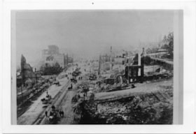
Aftermath of Great Fire of New Westminster, 1898
https://search.heritageburnaby.ca/link/museumdescription4781
- Repository
- Burnaby Village Museum
- Date
- 1898
- Collection/Fonds
- Burnaby Village Museum Photograph collection
- Description Level
- Item
- Physical Description
- 1 photograph : b&w ; 8.8 x 12.7 cm ; copy print
- Scope and Content
- Brick ruins of buildings on either side of a street with people, wagons and horses. Street runs top to bottom on left hand side of photograph.
- Repository
- Burnaby Village Museum
- Collection/Fonds
- Burnaby Village Museum Photograph collection
- Description Level
- Item
- Physical Description
- 1 photograph : b&w ; 8.8 x 12.7 cm ; copy print
- Material Details
- "Columbian files 1971" written on verso in black pen. ""FIRE" NEW WESTMINSTER SEPT. 1898." written on verso in pencil.
- Scope and Content
- Brick ruins of buildings on either side of a street with people, wagons and horses. Street runs top to bottom on left hand side of photograph.
- History
- Part of a set of photographs from the Columbian Newspaper, which operated out of New Westminster under this name starting in 1900 until its dissolution in 1988. Photographs found in the collection of the Burnaby Village are dated 1971.
- Other Title Information
- title based on content and note on verso of photograph
- Accession Code
- BV018.19.7
- Access Restriction
- No restrictions
- Reproduction Restriction
- May be restricted by third party rights
- Date
- 1898
- Media Type
- Photograph
- Scan Resolution
- 600
- Scan Date
- 24-04-2018
Images

![Alan Deacon, [1890] thumbnail](/media/hpo/_Data/_Archives_Images/_Unrestricted/477/477-1016.jpg?width=280)
Alan Deacon
https://search.heritageburnaby.ca/link/archivedescription66308
- Repository
- City of Burnaby Archives
- Date
- [1890]
- Collection/Fonds
- Peers Family and Hill Family fonds
- Description Level
- Item
- Physical Description
- 1 photograph
- Scope and Content
- Photograph is a portrait of Alan Deacon, husband to Kitty Deacon. Kitty Deacon was the sister of Annie Hill (nee Kenrick).
- Repository
- City of Burnaby Archives
- Date
- [1890]
- Collection/Fonds
- Peers Family and Hill Family fonds
- Physical Description
- 1 photograph
- Description Level
- Item
- Record No.
- 477-1016
- Access Restriction
- No restrictions
- Reproduction Restriction
- No known restrictions
- Accession Number
- 2007-12
- Scope and Content
- Photograph is a portrait of Alan Deacon, husband to Kitty Deacon. Kitty Deacon was the sister of Annie Hill (nee Kenrick).
- Names
- Deacon, Alan
- Media Type
- Photograph
- Notes
- Title based on contents of photograph
Images
![Alan Deacon, [1890] thumbnail](/media/hpo/_Data/_Archives_Images/_Unrestricted/477/477-1016.jpg)

Alfred Bingham's writings - Track 1
https://search.heritageburnaby.ca/link/oralhistory251
- Repository
- City of Burnaby Archives
- Date Range
- 1865-1919
- Length
- 0:10:18
- Summary
- This portion of the recording includes Alfred Bingham's essay entitled Stump Rangers, a listing of early settlers that includes addresses and short descriptions, essays on Confederation Park, land clearing and on Burnaby's first Council meeting.
- Repository
- City of Burnaby Archives
- Summary
- This portion of the recording includes Alfred Bingham's essay entitled Stump Rangers, a listing of early settlers that includes addresses and short descriptions, essays on Confederation Park, land clearing and on Burnaby's first Council meeting.
- Date Range
- 1865-1919
- Photo Info
- Alfred Bingham, April 20, 1947. Item no. 010-066
- Length
- 0:10:18
- Scope and Content
- Recording is of Alfred Bingham's writings, as read by Alfred Bingham. Major themes discussed are: Pioneers, early days in Burnaby and the Co-op Movement. To view "Narrow By" terms for each track expand this description and see "Notes".
- Biographical Notes
- Alfred "Alf" Bingham was born in England in 1892 and moved to Canada in 1912. His first job in Canada was laying track for the Grand Trunk Pacific Railway (GTPR) from Edmonton to McBride in 1912. His second was in Vancouver at the Rat Portage Mill on False Creek, working on the Resaw machine. He quit after one week due to poor working conditions. After taking part in the 1919 Winnipeg General Strike as a delegate of the Retail and Mailorder Union (A.F.L.) on the Winnipeg Trades and Labour Council, Alfred moved to Burnaby where he and fellow Burnaby residents Aungus McLean and Percy Little worked ten hour days to build a Shingle Mill on the edge of Burnaby Lake for Simpson & Giberson. George Green, carpenter and millwright (author of “The History of Burnaby”) also helped in the construction of the mill. Alfred built his own home from lumber cut from the mill in the Lochdale area on Sherlock Street between Curtis Street and Kitchener Street. On April 10, 1920 Alfred married Mary Jane “Ada” Reynolds. Alfred and Ada often took in foster children during their marriage. Due to her nursing experience, Ada was often called upon to deliver babies in the Burnaby area. Alfred and Ada Bingham were instrumental members of the Army of the Common Good, collecting vegetables and grains from growers in the area and even producing over 125 tons of vegetables from its own gardens to feed children and youth suffering from the lack of resources during the Depression years. The army was in operation for ten years and during that time the members organised the Credit Union movement of British Columbia and drew up the Credit Union act thorough the Vancouver Co-operative Council. They also started Co-Op stores and the Co-Op Wholesale Society. Alfred was also Secretary of the Burnaby Housing committee and in 1946 he became the Secretary of the North Burnaby Labour Progressive Party (LPP). Mary Jane “Ada” (Reynolds) Bingham died on August 9, 1969. Her husband Alfred died on April 29, 1979.
- Total Tracks
- 12
- Total Length
- 1:38:06
- Interviewee Name
- Bingham, Alfred "Alf"
- Collection/Fonds
- Burnaby Historical Society fonds
- Subseries
- Oral history subseries
- Transcript Available
- MSS142-001 contains transcripts for each of the short stories
- Media Type
- Sound Recording
- Web Notes
- Interview was digitized in 2010 allowing it to be accessible on Heritage Burnaby. The digitization project was initiated by the Community Heritage Commission with support from City of Burnaby Council and the BC History Digitization Program of the Irving K. Barber Learning Centre, University of British Columbia. It was recognized by the Heritage Society of BC with an award in 2012.
Images

Audio Tracks
Track one of recording of Alfred Bingham's writings
Track one of recording of Alfred Bingham's writings
https://search.heritageburnaby.ca/media/hpo/_Data/_Archives_Oral_Histories/_Unrestricted/100-13-20-2/100-13-20-2_Track_1.mp3
Alfred Bingham's writings - Track 4
https://search.heritageburnaby.ca/link/oralhistory254
- Repository
- City of Burnaby Archives
- Date Range
- 1892-1955
- Length
- 0:07:38
- Summary
- This portion of the recording includes Alfred Bingham's reading of an essay written by Captain Thomas S. Guns describing the Lozells district, as well as quoting single sentences of various other writers on the topic of Deer Lake and the Burnaby Lake District. Alfred mentions the first schools of B…
- Repository
- City of Burnaby Archives
- Summary
- This portion of the recording includes Alfred Bingham's reading of an essay written by Captain Thomas S. Guns describing the Lozells district, as well as quoting single sentences of various other writers on the topic of Deer Lake and the Burnaby Lake District. Alfred mentions the first schools of Burnaby Lake and the "pleasure walk" along Douglas Road, from Vancouver to New Westminster.
- Date Range
- 1892-1955
- Photo Info
- Alfred Bingham, April 20, 1947. Item no. 010-066
- Length
- 0:07:38
- Historic Neighbourhood
- Lozells (Historic Neighbourhood)
- Burnaby Lake (Historic Neighbourhood)
- Scope and Content
- Recording is of Alfred Bingham's writings, as read by Alfred Bingham. Major themes discussed are: Pioneers, early days in Burnaby and the Co-op Movement. To view "Narrow By" terms for each track expand this description and see "Notes".
- Biographical Notes
- Alfred "Alf" Bingham was born in England in 1892 and moved to Canada in 1912. His first job in Canada was laying track for the Grand Trunk Pacific Railway (GTPR) from Edmonton to McBride in 1912. His second was in Vancouver at the Rat Portage Mill on False Creek, working on the Resaw machine. He quit after one week due to poor working conditions. After taking part in the 1919 Winnipeg General Strike as a delegate of the Retail and Mailorder Union (A.F.L.) on the Winnipeg Trades and Labour Council, Alfred moved to Burnaby where he and fellow Burnaby residents Aungus McLean and Percy Little worked ten hour days to build a Shingle Mill on the edge of Burnaby Lake for Simpson & Giberson. George Green, carpenter and millwright (author of “The History of Burnaby”) also helped in the construction of the mill. Alfred built his own home from lumber cut from the mill in the Lochdale area on Sherlock Street between Curtis Street and Kitchener Street. On April 10, 1920 Alfred married Mary Jane “Ada” Reynolds. Alfred and Ada often took in foster children during their marriage. Due to her nursing experience, Ada was often called upon to deliver babies in the Burnaby area. Alfred and Ada Bingham were instrumental members of the Army of the Common Good, collecting vegetables and grains from growers in the area and even producing over 125 tons of vegetables from its own gardens to feed children and youth suffering from the lack of resources during the Depression years. The army was in operation for ten years and during that time the members organised the Credit Union movement of British Columbia and drew up the Credit Union act thorough the Vancouver Co-operative Council. They also started Co-Op stores and the Co-Op Wholesale Society. Alfred was also Secretary of the Burnaby Housing committee and in 1946 he became the Secretary of the North Burnaby Labour Progressive Party (LPP). Mary Jane “Ada” (Reynolds) Bingham died on August 9, 1969. Her husband Alfred died on April 29, 1979.
- Total Tracks
- 12
- Total Length
- 1:38:06
- Interviewee Name
- Bingham, Alfred "Alf"
- Collection/Fonds
- Burnaby Historical Society fonds
- Subseries
- Oral history subseries
- Transcript Available
- MSS142-001 contains transcripts for each of the short stories
- Media Type
- Sound Recording
- Web Notes
- Interview was digitized in 2010 allowing it to be accessible on Heritage Burnaby. The digitization project was initiated by the Community Heritage Commission with support from City of Burnaby Council and the BC History Digitization Program of the Irving K. Barber Learning Centre, University of British Columbia. It was recognized by the Heritage Society of BC with an award in 2012.
Images
Audio Tracks
Track four of recording of Alfred Bingham's writings
Track four of recording of Alfred Bingham's writings
https://search.heritageburnaby.ca/media/hpo/_Data/_Archives_Oral_Histories/_Unrestricted/100-13-20-2/100-13-20-2_Track_4.mp3
Alfred Bingham's writings - Track 8
https://search.heritageburnaby.ca/link/oralhistory258
- Repository
- City of Burnaby Archives
- Date Range
- 1892-1963
- Length
- 0:07:05
- Summary
- This portion of the recording includes Alfred Bingham's continuation of reading his series of short stories. He reads; "THE RUM RUNNERS AND BOOTLEG WHISKY IN BURNABY" and "BURNABY. NORTH. SOUTH. EAST? AND WEST 1892---1943" both written in 1963.
- Repository
- City of Burnaby Archives
- Summary
- This portion of the recording includes Alfred Bingham's continuation of reading his series of short stories. He reads; "THE RUM RUNNERS AND BOOTLEG WHISKY IN BURNABY" and "BURNABY. NORTH. SOUTH. EAST? AND WEST 1892---1943" both written in 1963.
- Date Range
- 1892-1963
- Photo Info
- Alfred Bingham, April 20, 1947. Item no. 010-066
- Length
- 0:07:05
- Names
- Hawthorn, Mary
- Scope and Content
- Recording is of Alfred Bingham's writings, as read by Alfred Bingham. Major themes discussed are: Pioneers, early days in Burnaby and the Co-op Movement. To view "Narrow By" terms for each track expand this description and see "Notes".
- Biographical Notes
- Alfred "Alf" Bingham was born in England in 1892 and moved to Canada in 1912. His first job in Canada was laying track for the Grand Trunk Pacific Railway (GTPR) from Edmonton to McBride in 1912. His second was in Vancouver at the Rat Portage Mill on False Creek, working on the Resaw machine. He quit after one week due to poor working conditions. After taking part in the 1919 Winnipeg General Strike as a delegate of the Retail and Mailorder Union (A.F.L.) on the Winnipeg Trades and Labour Council, Alfred moved to Burnaby where he and fellow Burnaby residents Aungus McLean and Percy Little worked ten hour days to build a Shingle Mill on the edge of Burnaby Lake for Simpson & Giberson. George Green, carpenter and millwright (author of “The History of Burnaby”) also helped in the construction of the mill. Alfred built his own home from lumber cut from the mill in the Lochdale area on Sherlock Street between Curtis Street and Kitchener Street. On April 10, 1920 Alfred married Mary Jane “Ada” Reynolds. Alfred and Ada often took in foster children during their marriage. Due to her nursing experience, Ada was often called upon to deliver babies in the Burnaby area. Alfred and Ada Bingham were instrumental members of the Army of the Common Good, collecting vegetables and grains from growers in the area and even producing over 125 tons of vegetables from its own gardens to feed children and youth suffering from the lack of resources during the Depression years. The army was in operation for ten years and during that time the members organised the Credit Union movement of British Columbia and drew up the Credit Union act thorough the Vancouver Co-operative Council. They also started Co-Op stores and the Co-Op Wholesale Society. Alfred was also Secretary of the Burnaby Housing committee and in 1946 he became the Secretary of the North Burnaby Labour Progressive Party (LPP). Mary Jane “Ada” (Reynolds) Bingham died on August 9, 1969. Her husband Alfred died on April 29, 1979.
- Total Tracks
- 12
- Total Length
- 1:38:06
- Interviewee Name
- Bingham, Alfred "Alf"
- Collection/Fonds
- Burnaby Historical Society fonds
- Subseries
- Oral history subseries
- Transcript Available
- MSS142-001 contains transcripts for each of the short stories
- Media Type
- Sound Recording
- Web Notes
- Interview was digitized in 2010 allowing it to be accessible on Heritage Burnaby. The digitization project was initiated by the Community Heritage Commission with support from City of Burnaby Council and the BC History Digitization Program of the Irving K. Barber Learning Centre, University of British Columbia. It was recognized by the Heritage Society of BC with an award in 2012.
Images
Audio Tracks
Track eight of recording of Alfred Bingham's writings
Track eight of recording of Alfred Bingham's writings
https://search.heritageburnaby.ca/media/hpo/_Data/_Archives_Oral_Histories/_Unrestricted/100-13-20-2/100-13-20-2_Track_8.mp3
Alice Hart photograph album
https://search.heritageburnaby.ca/link/museumdescription14366
- Repository
- Burnaby Village Museum
- Date
- 1893-1923 (date of original), copied 1976
- Collection/Fonds
- Florence Hart Godwin fonds
- Description Level
- File
- Physical Description
- 1 album (31 photographs: b&w negatives ; 35 mm)
- Scope and Content
- File consists of a photographic reproduction of a twenty nine page photograph album that was created by Alice Hart. Inscription inside of front cover reads "To dearest Alice from father 30th March 1906". The album is filled with photographs of the Hart family along with friends and relations. The p…
- Repository
- Burnaby Village Museum
- Collection/Fonds
- Florence Hart Godwin fonds
- Description Level
- File
- Physical Description
- 1 album (31 photographs: b&w negatives ; 35 mm)
- Scope and Content
- File consists of a photographic reproduction of a twenty nine page photograph album that was created by Alice Hart. Inscription inside of front cover reads "To dearest Alice from father 30th March 1906". The album is filled with photographs of the Hart family along with friends and relations. The photographs range between 1893 and 1923 and document time spent at residences in New Westminster, Deer Lake and Kerrisdale along with family vacations at Mayne Island, Stanely Park and Pitt Lake.
- Accession Code
- HV976.169.1
- Access Restriction
- No restrictions
- Reproduction Restriction
- No known restrictions
- Date
- 1893-1923 (date of original), copied 1976
- Media Type
- Photograph
- Textual Record
- Scan Date
- 10/27/2020
- Notes
- Title based on contents of photograph album
- Inscription on first page of album reads: "To dearest Alice / from father / 30th March, 1906”.
- 31 b&w copy prints accompanying
- Album pages are described at item level
Images

Documents
![Aliceville Hotel, [1892] thumbnail](/media/hpo/_Data/_Archives_Images/_Unrestricted/371/421-001.jpg?width=280)
Aliceville Hotel
https://search.heritageburnaby.ca/link/archivedescription38369
- Repository
- City of Burnaby Archives
- Date
- [1892]
- Collection/Fonds
- Burnaby Historical Society fonds
- Description Level
- Item
- Physical Description
- 1 photograph : b&w ; 10 x 12.5 cm
- Scope and Content
- Photograph of the Aliceville Hotel at Burrard Inlet which was built in 1892. On the back of the photograph, a map showing the hotel's location in relation to Hastings Street and North Road has been sketched in pencil.
- Repository
- City of Burnaby Archives
- Date
- [1892]
- Collection/Fonds
- Burnaby Historical Society fonds
- Subseries
- Photographs subseries
- Physical Description
- 1 photograph : b&w ; 10 x 12.5 cm
- Description Level
- Item
- Record No.
- 421-001
- Access Restriction
- No restrictions
- Reproduction Restriction
- No known restrictions
- Accession Number
- BHS2001-10
- Scope and Content
- Photograph of the Aliceville Hotel at Burrard Inlet which was built in 1892. On the back of the photograph, a map showing the hotel's location in relation to Hastings Street and North Road has been sketched in pencil.
- Names
- Aliceville Hotel
- Media Type
- Photograph
- Notes
- Title based on contents of photograph
- Geographic Access
- Hastings Street
- Barnet Road
- Street Address
- 9951 Barnet Road
- Planning Study Area
- Burnaby Mountain Area
Images
![Aliceville Hotel, [1892] thumbnail](/media/hpo/_Data/_Archives_Images/_Unrestricted/371/421-001.jpg)

Annie Kenrick
https://search.heritageburnaby.ca/link/archivedescription66193
- Repository
- City of Burnaby Archives
- Date
- 1890
- Collection/Fonds
- Peers Family and Hill Family fonds
- Description Level
- Item
- Physical Description
- 1 photograph : b&w ; 10 x 6 cm
- Scope and Content
- Photograph is a portrait of Annie Kenrick, likely taken as an engagement photograph prior to her marriage to Louis Claude Hill.
- Repository
- City of Burnaby Archives
- Date
- 1890
- Collection/Fonds
- Peers Family and Hill Family fonds
- Physical Description
- 1 photograph : b&w ; 10 x 6 cm
- Description Level
- Item
- Record No.
- 477-935
- Access Restriction
- No restrictions
- Reproduction Restriction
- No known restrictions
- Accession Number
- 2007-12
- Scope and Content
- Photograph is a portrait of Annie Kenrick, likely taken as an engagement photograph prior to her marriage to Louis Claude Hill.
- Names
- Hill, Annie Sara Kenrick
- Media Type
- Photograph
- Notes
- Title based on contents of photograph
- Photographer's information on recto
Images
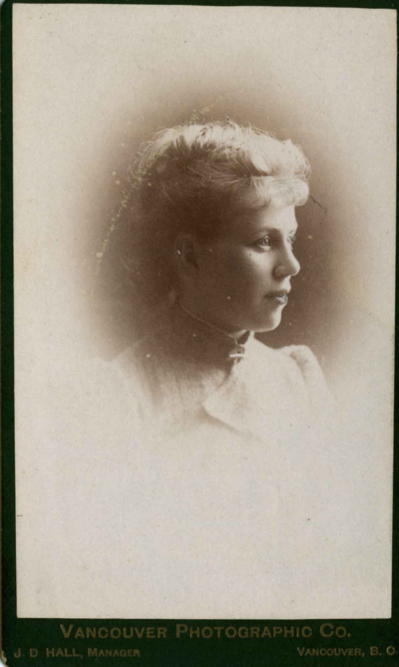
![Annie Sara Kenrick, [1890] thumbnail](/media/hpo/_Data/_Archives_Images/_Unrestricted/477/477-052.jpg?width=280)
Annie Sara Kenrick
https://search.heritageburnaby.ca/link/archivedescription38733
- Repository
- City of Burnaby Archives
- Date
- [1890]
- Collection/Fonds
- Peers Family and Hill Family fonds
- Description Level
- Item
- Physical Description
- 1 photograph : b&w ; 12 x 16 cm on mat 13 x 18 cm
- Scope and Content
- Photograph of Annie Sara Kenrick (later Annie Hill, upon her marriage to L. Claude Hill).
- Repository
- City of Burnaby Archives
- Date
- [1890]
- Collection/Fonds
- Peers Family and Hill Family fonds
- Physical Description
- 1 photograph : b&w ; 12 x 16 cm on mat 13 x 18 cm
- Description Level
- Item
- Record No.
- 477-052
- Access Restriction
- No restrictions
- Reproduction Restriction
- No known restrictions
- Accession Number
- 2007-12
- Scope and Content
- Photograph of Annie Sara Kenrick (later Annie Hill, upon her marriage to L. Claude Hill).
- Subjects
- Documentary Artifacts - Portraits
- Names
- Hill, Annie Sara Kenrick
- Media Type
- Photograph
- Notes
- Title based on contents of photograph
Images
![Annie Sara Kenrick, [1890] thumbnail](/media/hpo/_Data/_Archives_Images/_Unrestricted/477/477-052.jpg)
![Annie S. Hill, [1895] thumbnail](/media/hpo/_Data/_Archives_Images/_Unrestricted/477/477-054.jpg?width=280)
Annie S. Hill
https://search.heritageburnaby.ca/link/archivedescription38735
- Repository
- City of Burnaby Archives
- Date
- [1895]
- Collection/Fonds
- Peers Family and Hill Family fonds
- Description Level
- Item
- Physical Description
- 1 photograph : b&w ; 5.5 x 10 cm in glass and wood frame 6.5 x 10.5 cm
- Scope and Content
- Photograph is a studio portrait of Annie Sara Hill (formerly, Annie Kenrick).
- Repository
- City of Burnaby Archives
- Date
- [1895]
- Collection/Fonds
- Peers Family and Hill Family fonds
- Physical Description
- 1 photograph : b&w ; 5.5 x 10 cm in glass and wood frame 6.5 x 10.5 cm
- Description Level
- Item
- Record No.
- 477-054
- Access Restriction
- No restrictions
- Reproduction Restriction
- No known restrictions
- Accession Number
- 2007-12
- Scope and Content
- Photograph is a studio portrait of Annie Sara Hill (formerly, Annie Kenrick).
- Subjects
- Documentary Artifacts - Portraits
- Names
- Hill, Annie Sara Kenrick
- Media Type
- Photograph
- Photographer
- Catfords, James L.
- Notes
- Title based on contents of photograph
Images
![Annie S. Hill, [1895] thumbnail](/media/hpo/_Data/_Archives_Images/_Unrestricted/477/477-054.jpg)
![Annual Picnic, [189-?] thumbnail](/media/hpo/_Data/_BVM_Images/1983/1983_0042_0142_001.jpg?width=280)
Annual Picnic
https://search.heritageburnaby.ca/link/museumdescription402
- Repository
- Burnaby Village Museum
- Date
- [189-?]
- Collection/Fonds
- Burnaby Village Museum Photograph collection
- Description Level
- Item
- Physical Description
- 1 photograph : b&w postcard ; 8.89 x 12.07 cm
- Scope and Content
- Photographic postcard of 7 unidentified women in white dresses of the turn of the century period. They are all wearing hats, some lavishly decorated with feathers and silk flowers. The five women seated in the front are wearing award ribbons on their chests that say "ANNUAL PICNIC". The rest of the…
- Repository
- Burnaby Village Museum
- Collection/Fonds
- Burnaby Village Museum Photograph collection
- Description Level
- Item
- Physical Description
- 1 photograph : b&w postcard ; 8.89 x 12.07 cm
- Material Details
- The photograph is printed on a postcard paper. The postcard is copyrighted by the Chicago Ferrotype Company, 1911. The photo postcard is likely a reproduction of a ferrotype or a tintype photograph because the image tone is darker than B&W photographs printed on paper. The postcard is enclosed in a green folder with a lion face embossing on the cover.
- Scope and Content
- Photographic postcard of 7 unidentified women in white dresses of the turn of the century period. They are all wearing hats, some lavishly decorated with feathers and silk flowers. The five women seated in the front are wearing award ribbons on their chests that say "ANNUAL PICNIC". The rest of the writing on the ribbon is not decipherable. Two women are standing in the back. There appears to be a buliding and landscaped woods in the background.
- Subjects
- Recreational Activities - Picnics
- Accession Code
- HV983.42.142
- Reproduction Restriction
- No known restrictions
- Date
- [189-?]
- Media Type
- Photograph
- Scan Resolution
- 600
- Scan Date
- 2023-12-05
- Notes
- Title based on contents of photograph
Images
![Annual Picnic, [189-?] thumbnail](/media/hpo/_Data/_BVM_Images/1983/1983_0042_0142_001.jpg)

A Pig's Tale
https://search.heritageburnaby.ca/link/museumdescription14365
- Repository
- Burnaby Village Museum
- Date
- Oct. 2020
- Collection/Fonds
- Burnaby Village Museum fonds
- Description Level
- Item
- Physical Description
- 3 video recordings (mp4) (5 min., 28 sec.) : digital, col., sd., stereo, subtitles
- Scope and Content
- Item consists of part two in a two part video series "A Taste of History" created by Debbie Liang and Joty Gill, University of British Columbia alumni and graduates from the Asian Canadian & Asian Migration Studies program (ACAM). Part two is titled "A Pig's Tale". The film highlights the history o…
- Repository
- Burnaby Village Museum
- Collection/Fonds
- Burnaby Village Museum fonds
- Series
- UBC Partnership series
- Description Level
- Item
- Physical Description
- 3 video recordings (mp4) (5 min., 28 sec.) : digital, col., sd., stereo, subtitles
- Material Details
- Script: Debbie Liang; Joty Gill Narration: Joty Gill Editor: Debbie Liang Subtitles: English; Simplified Chinese; Traditional Chinese Video Appearances: Kathy Lee; Eleanor Lee Illustrations and Animations: Debbie Liang Photos, Images & B-roll: Piggery photo, image courtesy of Elwin Xie; Douglas Road: City of Burnaby Archives, 477-841; Canada Way, City of Burnaby Archives, 556-522, photo by Peg Campbell; Red pig by Debbie Liang; Piglets sleeping, image courtesy of RoyBuri from pixabay, free to use; Chinese Zodiac, image courtesy of RoofOfAllLight from wikimedia, Creative Commons Attribution-Share Alike 4.0 International license; Pictograph for Home by Debbie Liang; Pigs lying down, image courtesy of Elwin Xie; Council minutes all from heritageburnaby.com; Cleanliness illustration set by Debbie Liang; "The Heathen Chinese in British Columbia" from Library and Archives Canada; Laundryman spitting from Daily News, Prince Rupert in 1911; Slicer on counter at Way Sang Yuen Wat Kee & Co., Burnaby Village Museum BV017.7.290; Way Sang Yuen Wat Kee & Co. Store front, Burnaby Village Museum BV017.7.191; Medical Practices Disagreement illustration by Debbie Liang; Butchering pig, image courtesy of Elwin Xie; Chinatown brolls, courtesy of Food2 group from UBC's 2019 ACAM 390 Class; Black Rotary telephone beside ball pen on white printed paper, image courtesy of Pixabay from pexels.com, free to use; Burnaby Lake on a cloudy day, image courtesy of Flying Pegunin from wikipedia; The Vancouver Sun May 4, 1921 from newspapers.com; Vancouver Daily May 3, 1921 from newspapers.com; Reduce number of pigs illustration by Debbie Liang; Black and white photo of piggery, image courtesy of Elwin Xie; 2019 Piggery illustration by Debbie Liang Music and Sound Effects: "Acoustic Mediation 2" from audionautix; Pig Grunting sounds from Kiddopedia Animasl, Creative Commons 0; "Piano moment" & "November" from bensound.com; "Ding sound effect" from freesoundlibrary; Wuxia2_Guzheng_Pipa by PeriTune http://peritune.com; Music promoted by https://www.free-stock-music.com; Attribution 4.0 International (CC BY 4.0) https://creativecommons.org/licenses/by/4.0/ Video adapted from 2019 BVM intern project by Debbie Liang and Marcela Gomez Special thanks to: UBC: Joanna Yang, Jenny Lu, Denise Fong, Henry Yu; BVM: Kate Petrusa, Amy Wilson Changes to music may have been made for the purposes of this video
- Scope and Content
- Item consists of part two in a two part video series "A Taste of History" created by Debbie Liang and Joty Gill, University of British Columbia alumni and graduates from the Asian Canadian & Asian Migration Studies program (ACAM). Part two is titled "A Pig's Tale". The film highlights the history of Chinese pig farms also known as "Piggeries" in Burnaby. The film tells the story of how many of these farms were established by Chinese immigrants along Douglas Road (now Canada Way) between the 1890s and 1920s; the importance of the pig in the Chinese Culture as well as a way for Chinese immigrants to make a living and the racism and discriminatory bylaws that the Chinese pig farmers suffered that finally led to the closure of many of these farms. Content references three documented piggery ranches along Douglas Road: Ah Sam; Young Chung and Hop Hin Yen. The films are supported with voice over in english, subtitles, animation along with historical photographs. One version of the film is supported with subtitles in English while two other versions of the film are supported with subtitles in Simplified Chinese and Traditional Chinese.
- History
- In 2020, due to the restrictions of COVID-19, University of British Columbia student interns with the Burnaby Village Museum Chinese Canadian History in Burnaby project were asked to create virtual experiences to reimagine Burnaby Village Museum's historical Chinese Canadian programming in remote online spaces. Debbie Liang and Joty Gill (UBC alumni and graduates of Dr. Henry Yu's 2019 summer ACAM 390A Global Seminar to Aisa) returned to work with Burnaby Village Museum to create two short films showcasing the history of Chinese Canadian Chop Suey restaurants and piggeries in Burnaby.
- Creator
- Liang, Debbie
- Debbie Liang
- Subjects
- Persons - Chinese Canadians
- Social Issues - Discrimination
- Social Issues - Racism
- Regulations
- Agriculture
- Agriculture - Farms
- Agriculture - Ranches
- Animals - Pigs
- Names
- Liang, Debbie
- Gill, Joty
- Burnaby Village Museum
- University of British Columbia
- Xie, Elwin
- Way Sang Yuen Wat Kee & Company
- Ah Sam
- Young Chung
- Hop Hin Yen
- Responsibility
- University of British Columbia
- UBC Initiative for Student Teaching and Research in Chinese Canadian Studies
- Burnaby Village Museum
- Geographic Access
- Douglas Road
- Canada Way
- Accession Code
- BV020.28.7
- Access Restriction
- No restrictions
- Reproduction Restriction
- No known restrictions
- Date
- Oct. 2020
- Media Type
- Moving Images
- Historic Neighbourhood
- Burnaby Lake (Historic Neighbourhood)
- Planning Study Area
- Douglas-Gilpin Area
- Notes
- Transcribed title
Images


Video
A Pig's Tale, Oct. 2020
A Pig's Tale, Oct. 2020
https://search.heritageburnaby.ca/media/hpo/_Data/_BVM_Moving_Images/2020_0028_0007_001.mp4
April visit with the Romero family
https://search.heritageburnaby.ca/link/museumdescription14747
- Repository
- Burnaby Village Museum
- Date
- 19 Apr. 2020
- Collection/Fonds
- Burnaby Village Museum COVID-19 collection
- Description Level
- Item
- Physical Description
- 1 photograph (jpg) : col. ; 72 dpi.
- Scope and Content
- Photograph of the Romero family visiting with Lorna and John Court in their yard outside of their house on Imperial Street in Burnaby. Gabriel and Gisela are seated with thier children Alicia and Pablo while John Court stands in the back corner of the yard. John is holding his hands out to show tha…
- Repository
- Burnaby Village Museum
- Collection/Fonds
- Burnaby Village Museum COVID-19 collection
- Description Level
- Item
- Physical Description
- 1 photograph (jpg) : col. ; 72 dpi.
- Scope and Content
- Photograph of the Romero family visiting with Lorna and John Court in their yard outside of their house on Imperial Street in Burnaby. Gabriel and Gisela are seated with thier children Alicia and Pablo while John Court stands in the back corner of the yard. John is holding his hands out to show that they are physcially distanced. During the visit they set up two family groups of chairs spaced far apart due to the COVID-19 pandemic and public health recommendations.
- History
- The photographer, Lorna Court took this picture during the COVID-19 pandemic.
- Subjects
- Pandemics - COVID-19
- Geographic Access
- Imperial Street
- Accession Code
- BV020.30.7
- Access Restriction
- No restrictions
- Reproduction Restriction
- No known restrictions
- Date
- 19 Apr. 2020
- Media Type
- Photograph
- Planning Study Area
- Morley-Buckingham Area
- Photographer
- Court, Lorna
- Notes
- Title based on contents of photograph
Images

Are we really changing? Reflections on Reconciliation
https://search.heritageburnaby.ca/link/museumdescription15669
- Repository
- Burnaby Village Museum
- Date
- 12 May 2021
- Collection/Fonds
- Burnaby Village Museum fonds
- Description Level
- Item
- Physical Description
- 1 video recording (mp4) (91 min., 26 sec.) : digital, col., sd., stereo ; 29 fps
- Scope and Content
- Item consists of a video recording of a live Zoom webinar hosted by Burnaby Village Museum Curator, Jane Lemke. The webinar is titled "Are We Really Changing? Reflections on Reconciliation" and is presented by Brandon Gabriel, visual arts from the Kwantlen First Nation. The Zoom webinar is the sixt…
- Repository
- Burnaby Village Museum
- Collection/Fonds
- Burnaby Village Museum fonds
- Description Level
- Item
- Physical Description
- 1 video recording (mp4) (91 min., 26 sec.) : digital, col., sd., stereo ; 29 fps
- Material Details
- Presenter: Brandon Gabriel
- Host: Jane Lemke
- Date of Presentation: Wednesday, May 12, 7:00 pm - 8:30 pm
- Total Number of tracks: 1
- Total Length of all tracks: min., sec.
- Recording Device: Zoom video communication platform
- Recording Note: Film was edited from it's original recorded version (92 min., 31 sec.) to edited version (91 min., 26 sec.) for public viewing on Heritage Burnaby.
- Scope and Content
- Item consists of a video recording of a live Zoom webinar hosted by Burnaby Village Museum Curator, Jane Lemke. The webinar is titled "Are We Really Changing? Reflections on Reconciliation" and is presented by Brandon Gabriel, visual arts from the Kwantlen First Nation. The Zoom webinar is the sixth in a series of six "Neighbourhood Speaker Series" webinars exploring a range of topics shared by Indigenous speakers and knowledge keepers that were presented and made available to the public between April 27 and May 12, 2021. The live webinar was also made available on the Burnaby Village Museum's facebook page. Community members were invited to participate by bringing questions and comments during the interactive online sessions. In this webinar, Brandon supports his presentation with slides and explores the following questions; If we have not changed the way we introduce ourselves to each other and this land then what are we reconciling?" and "If resource exploitation, racism and colonization continue today, how can we change?" Brandon Gabriel, mixed-media artist and activist, looks back at some highlights of his twenty seven year artistic journey and shares what you can do to tackle reconciliation in your own life. Brandon presents counter narratives speaking to the importance of: Land; Languages; Colonial Annihilation and Indigenous Resurgence. Brandon pauses half way through his presentation to ask and reflect on the question "How far back do you know your ancestors on your mother's side?". While listeners are reflecting, Brandon shares a recording of Dennis Leon of Kwantlen First Nation performing the song “True Love”. Following this, Brandon takes questions from the audience and comments on the importance of matriarchal lineage in indigenous culture. In the second half of the presentation, Brandon talks about his own art and shares examples of Indigenous artists work including: Bill Reid, Zacharias Kunuk, Marianne Nicholson; Brian Jungan and Rebecca Bellmore. Following the presentation, Brandon Gabriel takes questions from the audience that are moderated by the host, Jane Lemke.
- History
- Brandon Gabriel is an award winning, and Internationally recognized visual artist from the Kwantlen First Nation, in unceded Fort Langley B.C. Brandon was educated at Kwantlen Polytechnic University (1999-2003) and at Emily Carr University of Art and Design (2003-2006). Brandon has over twenty seven years of professional experience as a designer, wood carver, mixed media sculptor, graphic designer, illustrator, and educator. He has exhibited works in the United Kingdom, Hong Kong, South America, the USA, and across Canada.
- Creator
- Burnaby Village Museum
- Subjects
- Indigenous peoples - British Columbia
- Indigenous peoples - British Columbia - Art
- Indigenous peoples - Canada - Government relations
- Indigenous peoples - Canada - , Treatment of
- Responsibility
- Lemke, Jane
- Accession Code
- BV021.17.6
- Access Restriction
- No restrictions
- Reproduction Restriction
- No known restrictions
- Date
- 12 May 2021
- Media Type
- Moving Images
- Notes
- Title based on content of video recording The following link was shared at the end of the presentation: Kwantlen First Nation: https://www.kwantlenfn.ca/
Images
Video
Are we really changing? Reflections on Reconciliation, 12 May 2021
Are we really changing? Reflections on Reconciliation, 12 May 2021
https://search.heritageburnaby.ca/media/hpo/_Data/_BVM_Moving_Images/2021_0017_0006_002.mp4![Baby, [189-] thumbnail](/media/hpo/_Data/_BVM_Images/1983/1983_0042_0124_001.jpg?width=280)
Baby
https://search.heritageburnaby.ca/link/museumdescription384
- Repository
- Burnaby Village Museum
- Date
- [189-]
- Collection/Fonds
- Burnaby Village Museum Photograph collection
- Description Level
- Item
- Physical Description
- 1 photograph : b&w ; 6.35 x 10.16 cm
- Scope and Content
- Photograph of a baby wearing a lace trimmed dress. The baby is sitting on a sofa with cushions at her back. A person's hand is visible, holding up the baby. The inscription on the cardmount of the photograph identifies the baby as Berla or Bertha E. Beallie (sp?) at age 9 months. She was 23.5 lbs.
- Repository
- Burnaby Village Museum
- Collection/Fonds
- Burnaby Village Museum Photograph collection
- Description Level
- Item
- Physical Description
- 1 photograph : b&w ; 6.35 x 10.16 cm
- Material Details
- printed on the card mount, recto, l.l. "HART'S,", l.r. "WATERTOWN, N. Y."
- inscribed in pencil on the card mount, verso, t. "Berla [or Bertha] E. Beallie [sp?]/ 9months/ 23 1/2 lbs"
- The photograph is mounted on a card supplied by the photo studio. The edges of the card are coloured gold
- Scope and Content
- Photograph of a baby wearing a lace trimmed dress. The baby is sitting on a sofa with cushions at her back. A person's hand is visible, holding up the baby. The inscription on the cardmount of the photograph identifies the baby as Berla or Bertha E. Beallie (sp?) at age 9 months. She was 23.5 lbs.
- Subjects
- Persons - Children
- Names
- Beallie, Bertha
- Accession Code
- HV983.42.124
- Reproduction Restriction
- No known restrictions
- Date
- [189-]
- Media Type
- Photograph
- Scan Resolution
- 600
- Scan Date
- 2023-11-21
- Scale
- 100
- Photographer
- Hart's Studio
- Notes
- Title based on contents of photograph
Images
![Baby, [189-] thumbnail](/media/hpo/_Data/_BVM_Images/1983/1983_0042_0124_001.jpg)

Basketball Court Closed
https://search.heritageburnaby.ca/link/archivedescription95116
- Repository
- City of Burnaby Archives
- Date
- May 8, 2020
- Collection/Fonds
- Burnaby Photographic Society fonds
- Description Level
- Item
- Physical Description
- 1 photograph (tiff)
- Scope and Content
- Photograph of a closed basketball court at Edmonds Park. A City of Burnaby facility closure sign is attached to the fence outside the court and the basketball hoops are covered with thick orange netting.
- Repository
- City of Burnaby Archives
- Date
- May 8, 2020
- Collection/Fonds
- Burnaby Photographic Society fonds
- Physical Description
- 1 photograph (tiff)
- Description Level
- Item
- Record No.
- 623-034
- Access Restriction
- No restrictions
- Reproduction Restriction
- No restrictions
- Accession Number
- 2020-10
- Scope and Content
- Photograph of a closed basketball court at Edmonds Park. A City of Burnaby facility closure sign is attached to the fence outside the court and the basketball hoops are covered with thick orange netting.
- Media Type
- Photograph
- Photographer
- Peterman, Randall
- Notes
- Transcribed title
- Geographic Access
- Humphries Avenue
- Street Address
- 7433 Humphries Avenue
- Historic Neighbourhood
- Edmonds (Historic Neighbourhood)
- Planning Study Area
- Richmond Park Area
Images

![Bateman family, [1891] thumbnail](/media/hpo/_Data/_BVM_Images/1974/197400220005.jpg?width=280)
Bateman family
https://search.heritageburnaby.ca/link/museumdescription915
- Repository
- Burnaby Village Museum
- Date
- [1891]
- Collection/Fonds
- E.W. Bateman family fonds
- Description Level
- Item
- Physical Description
- 1 photograph : b&w ; 14.2 x 10.1 cm mounted on cardboard 15.8 x 10.8 cm
- Scope and Content
- Photograph of Edwin W. Bateman and his first wife, Catherine "Cassie" Dale Bateman, seated on chairs in a photographic studio. Edwin is holding his eldest daughter Edna as she stands between her parents. Cassie Bateman is holding her baby son George on her lap.
- Repository
- Burnaby Village Museum
- Collection/Fonds
- E.W. Bateman family fonds
- Description Level
- Item
- Physical Description
- 1 photograph : b&w ; 14.2 x 10.1 cm mounted on cardboard 15.8 x 10.8 cm
- Scope and Content
- Photograph of Edwin W. Bateman and his first wife, Catherine "Cassie" Dale Bateman, seated on chairs in a photographic studio. Edwin is holding his eldest daughter Edna as she stands between her parents. Cassie Bateman is holding her baby son George on her lap.
- Accession Code
- HV974.22.5
- Access Restriction
- No restrictions
- Reproduction Restriction
- No known restrictions
- Date
- [1891]
- Media Type
- Photograph
- Related Material
- Earlier catalogue record indicates that there is more information on the Bateman Family in the BVM archives.
- Scan Resolution
- 600
- Scan Date
- 2023-04-25
- Photographer
- Rowe, J.F.
- Notes
- Title based on contents of photograph
- Printed on the bottom front of the card: "Rowe / Saskatchewan Ave., Portage La Prairie, Man."
- Photograph is mounted on a card provided by J. F. Rowe photo studio
- Printed on the back of the card: "From the Studio of J.F. Rowe / Photographer, Saskatchewan Ave., Portage La Prairie, Man. / All work made by the rapid dry plate process / Copying and enlarging a specialty / Negatives preserved."
Images
![Bateman family, [1891] thumbnail](/media/hpo/_Data/_BVM_Images/1974/197400220005.jpg)
![B.C. Sugar Refinery Picnic, [1897] thumbnail](/media/hpo/_Data/_BVM_Images/1976/1976_0036_0029_001.jpg?width=280)
B.C. Sugar Refinery Picnic
https://search.heritageburnaby.ca/link/museumdescription667
- Repository
- Burnaby Village Museum
- Date
- [1897]
- Collection/Fonds
- Burnaby Village Museum Photograph collection
- Description Level
- Item
- Physical Description
- 1 photograph : b&w ; 17 x 38 cm
- Scope and Content
- Photograph of a large group picnic. Banners tied between two trees behind the group read "B.C.S.[last letter obscured by an individual] 6th ANNUAL PICNIC" and "ROGERS' GOLDEN SYRUP." It is speculated that this photograph is of the British Columbia Sugar Refining Company's (sixth annual) picnic.
- Repository
- Burnaby Village Museum
- Collection/Fonds
- Burnaby Village Museum Photograph collection
- Description Level
- Item
- Physical Description
- 1 photograph : b&w ; 17 x 38 cm
- Scope and Content
- Photograph of a large group picnic. Banners tied between two trees behind the group read "B.C.S.[last letter obscured by an individual] 6th ANNUAL PICNIC" and "ROGERS' GOLDEN SYRUP." It is speculated that this photograph is of the British Columbia Sugar Refining Company's (sixth annual) picnic.
- Subjects
- Recreational Activities - Picnics
- Accession Code
- HV976.36.29
- Access Restriction
- No restrictions
- Reproduction Restriction
- No known restrictions
- Date
- [1897]
- Media Type
- Photograph
- Scan Resolution
- 300
- Scan Date
- 17/8/2006
- Scale
- 100
- Photographer
- Dominion Photo Studio
- Notes
- Title based on contents of photograph
Images
![B.C. Sugar Refinery Picnic, [1897] thumbnail](/media/hpo/_Data/_BVM_Images/1976/1976_0036_0029_001.jpg)
![Bernard Hill, [1890] thumbnail](/media/hpo/_Data/_Archives_Images/_Unrestricted/477/477-1024.jpg?width=280)
Bernard Hill
https://search.heritageburnaby.ca/link/archivedescription66316
- Repository
- City of Burnaby Archives
- Date
- [1890]
- Collection/Fonds
- Peers Family and Hill Family fonds
- Description Level
- Item
- Physical Description
- 1 photograph
- Scope and Content
- Photograph is a portrait of Bernard Hill.
- Repository
- City of Burnaby Archives
- Date
- [1890]
- Collection/Fonds
- Peers Family and Hill Family fonds
- Physical Description
- 1 photograph
- Description Level
- Item
- Record No.
- 477-1024
- Access Restriction
- No restrictions
- Reproduction Restriction
- No known restrictions
- Accession Number
- 2007-12
- Scope and Content
- Photograph is a portrait of Bernard Hill.
- Names
- Hill, Bernard R.
- Media Type
- Photograph
- Notes
- Title based on contents of photograph
Images
![Bernard Hill, [1890] thumbnail](/media/hpo/_Data/_Archives_Images/_Unrestricted/477/477-1024.jpg)
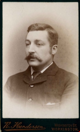
Bernard R. Hill
https://search.heritageburnaby.ca/link/archivedescription66195
- Repository
- City of Burnaby Archives
- Date
- 1890
- Collection/Fonds
- Peers Family and Hill Family fonds
- Description Level
- Item
- Physical Description
- 1 photograph : b&w ; 10 x 6 cm
- Scope and Content
- Photograph is a portrait of Bernard Hill.
- Repository
- City of Burnaby Archives
- Date
- 1890
- Collection/Fonds
- Peers Family and Hill Family fonds
- Physical Description
- 1 photograph : b&w ; 10 x 6 cm
- Description Level
- Item
- Record No.
- 477-936
- Access Restriction
- No restrictions
- Reproduction Restriction
- No known restrictions
- Accession Number
- 2007-12
- Scope and Content
- Photograph is a portrait of Bernard Hill.
- Names
- Hill, Bernard R.
- Media Type
- Photograph
- Notes
- Title based on contents of photograph
- Photographer's information on recto
Images
Births of Jesse and Martha Love
https://search.heritageburnaby.ca/link/museumdescription16926
- Repository
- Burnaby Village Museum
- Date
- 1879-1902
- Collection/Fonds
- Love family fonds
- Description Level
- Item
- Physical Description
- 1 p. : 24 x 30 cm
- Scope and Content
- Item consists of a births record page listing the children of Jesse and Martha Love. The page is presumed to be removed from a bible, potentially the Love family bible (BV992.26.1). The information on the obverse reads "Births / George Richard Love born 6:30 P.M March 22nd 1880 / Annie Elizabeth " …
- Repository
- Burnaby Village Museum
- Collection/Fonds
- Love family fonds
- Description Level
- Item
- Physical Description
- 1 p. : 24 x 30 cm
- Scope and Content
- Item consists of a births record page listing the children of Jesse and Martha Love. The page is presumed to be removed from a bible, potentially the Love family bible (BV992.26.1). The information on the obverse reads "Births / George Richard Love born 6:30 P.M March 22nd 1880 / Annie Elizabeth " August 24 1881 / Henry Love " August 24th 1883 / Edith Minnie " October 9th 1885 / Thomas Robert " September 17th 1887 / Martha "December 17th 1889 / Sarah Maria " February 8th 1892 / Phoebe Leonard April 15th 1894 / Esther August 28th 1896 / John Leonard June 7th 1899 / Hannah May 12th 1902". The reverse reads "Deaths" with no further notations.
- Accession Code
- BV992.26.30
- Access Restriction
- No restrictions
- Reproduction Restriction
- No known restrictions
- Date
- 1879-1902
- Media Type
- Textual Record
- Scan Resolution
- 600
- Scan Date
- 2022-06-10
- Notes
- Title based on the content of the page
Images