Narrow Results By
Decade
- 2020s 66
- 2010s 99
- 2000s 95
- 1990s 207
- 1980s 151
- 1970s 220
- 1960s
- 1950s 204
- 1940s 215
- 1930s 180
- 1920s 127
- 1910s 125
- 1900s 68
- 1890s 27
- 1880s 12
- 1870s 3
- 1860s 2
- 1850s 2
- 1840s 1
- 1830s 1
- 1820s 1
- 1810s 1
- 1800s 1
- 1790s 1
- 1780s
- 1770s 1
- 1760s 1
- 1750s 1
- 1740s 1
- 1730s 1
- 1720s 1
- 1710s 1
- 1700s 1
- 1690s 1
- 1680s 1
- 1670s
- 1660s 1
- 1650s 1
- 1640s 1
- 1630s 1
- 1620s 1
- 1610s 1
- 1600s 1
Subject
- Aerial Photographs 4
- Agriculture 1
- Agriculture - Farms 1
- Arts - Paintings 1
- Buildings 1
- Buildings - Civic 1
- Buildings - Commercial 1
- Buildings - Commercial - Department Stores 1
- Buildings - Commercial - Drive-In Theatres 1
- Buildings - Commercial - Grocery Stores 1
- Buildings - Commercial - Restaurants 3
- Buildings - Industrial 8
Creator
- Binks, James 2
- Burch, D. S. (Dallas Stockwell), 1886- 1
- Burnaby Village Museum 8
- Canada. Department of Mines and Technical Surveys. Geographical Branch 1
- Canadian National Railways 1
- Canadian Pacific Railway Company 1
- Chittick, Bob 1
- Chow, Hipman "Jimmy" 1
- City of Winnipeg 1
- Confederation Community Centre for the Retired 1
- Damer, Eric 1
- Dominion Photo Company 1
Better Home Remodelling, B.H. R. Industries Ltd. And Mr. Paul Frigstad
https://search.heritageburnaby.ca/link/councilreport36806
- Repository
- City of Burnaby Archives
- Report ID
- 32022
- Meeting Date
- 11-Jan-1965
- Format
- Council - Manager's Report
- Manager's Report No.
- 2
- Item No.
- 6
- Collection/Fonds
- City Council and Office of the City Clerk fonds
- Repository
- City of Burnaby Archives
- Report ID
- 32022
- Meeting Date
- 11-Jan-1965
- Format
- Council - Manager's Report
- Manager's Report No.
- 2
- Item No.
- 6
- Collection/Fonds
- City Council and Office of the City Clerk fonds
Documents
Catalogue No. 9 : supplies and small appliances for the printing and allied graphic arts industries
https://search.heritageburnaby.ca/link/museumlibrary5888
- Repository
- Burnaby Village Museum
- Collection
- Reference Collection
- Material Type
- Book
- Call Number
- 655.2 TOR
- Place of Publication
- Toronto
- Publisher
- Toronto Type Foundry Company
- Publication Date
- 1960
- Physical Description
- 65, [2] p. : ill. ; 29 cm.
- Library Subject (LOC)
- Printing--Specimens
- Type and type-founding
- Catalogs
- Notes
- Includes index.
- Includes pocket with several order forms.
Holland and Emily Street Ends (MacMillan Bloedel Industries Ltd.)
https://search.heritageburnaby.ca/link/councilreport34110
- Repository
- City of Burnaby Archives
- Report ID
- 31067
- Meeting Date
- 18-Dec-1967
- Format
- Council - Manager's Report
- Manager's Report No.
- 81
- Item No.
- 6
- Collection/Fonds
- City Council and Office of the City Clerk fonds
- Repository
- City of Burnaby Archives
- Report ID
- 31067
- Meeting Date
- 18-Dec-1967
- Format
- Council - Manager's Report
- Manager's Report No.
- 81
- Item No.
- 6
- Collection/Fonds
- City Council and Office of the City Clerk fonds
Documents
Holland and Emily Street Ends (MacMillan Bloedel Industries Ltd.)
https://search.heritageburnaby.ca/link/councilreport34933
- Repository
- City of Burnaby Archives
- Report ID
- 30278
- Meeting Date
- 6-Feb-1967
- Format
- Council - Manager's Report
- Manager's Report No.
- 7
- Item No.
- 4
- Collection/Fonds
- City Council and Office of the City Clerk fonds
- Repository
- City of Burnaby Archives
- Report ID
- 30278
- Meeting Date
- 6-Feb-1967
- Format
- Council - Manager's Report
- Manager's Report No.
- 7
- Item No.
- 4
- Collection/Fonds
- City Council and Office of the City Clerk fonds
Documents
Holland and Emily Street Ends (McMillan Bloedel Industries Ltd.)
https://search.heritageburnaby.ca/link/councilreport33066
- Repository
- City of Burnaby Archives
- Report ID
- 28234
- Meeting Date
- 17-Feb-1969
- Format
- Council - Manager's Report
- Manager's Report No.
- 11
- Item No.
- 4
- Collection/Fonds
- City Council and Office of the City Clerk fonds
- Repository
- City of Burnaby Archives
- Report ID
- 28234
- Meeting Date
- 17-Feb-1969
- Format
- Council - Manager's Report
- Manager's Report No.
- 11
- Item No.
- 4
- Collection/Fonds
- City Council and Office of the City Clerk fonds
Documents
Imperial Industries Ltd. - Antrim Avenue
https://search.heritageburnaby.ca/link/councilreport37601
- Repository
- City of Burnaby Archives
- Report ID
- 33196
- Meeting Date
- 6-Apr-1964
- Format
- Council - Manager's Report
- Manager's Report No.
- 23
- Item No.
- 7
- Collection/Fonds
- City Council and Office of the City Clerk fonds
- Repository
- City of Burnaby Archives
- Report ID
- 33196
- Meeting Date
- 6-Apr-1964
- Format
- Council - Manager's Report
- Manager's Report No.
- 23
- Item No.
- 7
- Collection/Fonds
- City Council and Office of the City Clerk fonds
Documents
Street Ends of Holland and Emily Streets (MacMillan Bloedel and Powell River Industries Ltd.)
https://search.heritageburnaby.ca/link/councilreport35439
- Repository
- City of Burnaby Archives
- Report ID
- 31542
- Meeting Date
- 27-Jun-1966
- Format
- Council - Manager's Report
- Manager's Report No.
- 37
- Item No.
- 10
- Collection/Fonds
- City Council and Office of the City Clerk fonds
- Repository
- City of Burnaby Archives
- Report ID
- 31542
- Meeting Date
- 27-Jun-1966
- Format
- Council - Manager's Report
- Manager's Report No.
- 37
- Item No.
- 10
- Collection/Fonds
- City Council and Office of the City Clerk fonds
Documents
Toronto Type Foundry Company : catalogue 9 , supplies and small appliances for the printing and allied graphic arts industries
https://search.heritageburnaby.ca/link/museumlibrary6665
- Repository
- Burnaby Village Museum
- Collection
- Reference Collection
- Material Type
- Book
- Call Number
- 686 TOR
- Place of Publication
- Toronto
- Publisher
- Toronto Type Foundry Company
- Publication Date
- 1960
- Physical Description
- vi, 64 p. : ill. ; 29 cm.
- Library Subject (LOC)
- Type and type-founding
- Catalogs
- Notes
- Includes index
- Logo is TTF which are the company's intials

Big Bend Neighbourhood
https://search.heritageburnaby.ca/link/landmark840
- Repository
- Burnaby Heritage Planning
- Associated Dates
- 1955-2008
- Heritage Value
- The Big Bend Neighbourhood in Burnaby maintained its status as an important agricultural area in the City in the years following 1955 and it also solidified its role as a prime industrial and commercial district. In 1972, the Big Bend Development Plan was adopted by Council and soon thereafter, approximately 620 acres of land were incorporated into the Agricultural Land Reserve. These lands have been set aside for agricultural and limited recreation purposes. By the 2000s, 160 acres of land were considered highly productive agricultural areas, and over 400 acres of land had been secured as parkland, including the Fraser Foreshore Park. The area also developed large commercial and industrial districts including those at Marine Way/Boundary, the Glenlyon Estates, Riverfront Business Park, Burnaby Business Park, and Glenwood Industrial Estates.
- Historic Neighbourhood
- Fraser Arm (Historic Neighbourhood)
- Planning Study Area
- Big Bend Area
Images


Lake City Neighbourhood
https://search.heritageburnaby.ca/link/landmark793
- Repository
- Burnaby Heritage Planning
- Associated Dates
- 1955-2008
- Heritage Value
- When Simon Fraser University opened in 1965, approximately sixteen industrial properties had been developed in the Lake City Industrial Park. In addition, significant tracts of land in the western portion had been pre-cleared and graded in anticipation of additional development, while most of the eastern half remained forested. Some of the early companies to locate in the area were Nabob Foods, Volkswagen Canada, British Columbia Television Broadcasting, Simpson Sears, and H.Y. Louie Company Limited. Both Imperial Oil and Shell Oil established petroleum storage and distribution facilities in the area. Initially a heavy industrial area, by 1979, single family neighbourhoods south of Lougheed Highway and west of Eagle Creek had been largely developed. By the mid1980's, the Burnaby 200 multi-family development along Forest Grove Drive had also been completed.
- Planning Study Area
- Lake City Area
Images


Dawson-Delta Neighbourhood
https://search.heritageburnaby.ca/link/landmark779
- Repository
- Burnaby Heritage Planning
- Associated Dates
- 1955-2008
- Heritage Value
- The Dawson-Delta neighbourhood in Burnaby developed into one of Burnaby's numerous industrial areas after 1955. The Eastbrook Executive Business Park opened in the 1970s and the Willingdon Green Business Centre includes buildings from the 1980s to the 2000s. Convenient access to major roads and highways fostered these developments which remain zoned for industrial uses to this day.
- Planning Study Area
- Dawson-Delta Area
Images


Burnaby South High School
https://search.heritageburnaby.ca/link/landmark770
- Repository
- Burnaby Heritage Planning
- Associated Dates
- 1922-1988
- Street View URL
- Google Maps Street View
- Repository
- Burnaby Heritage Planning
- Geographic Access
- Southoaks Crescent
- Associated Dates
- 1922-1988
- Heritage Value
- Burnaby South and Burnaby North were Burnaby's first high schools. The first rooms of the school were built in 1922 on the same grounds as the Kingsway East Elementary School. In 1940, a two-storey building was erected and additions were made in 1963, 1967 and 1972. Kingsway East closed in 1925 and its buildings were used by the high school for Industrial Arts and Home Economics. In the early 1990s, a new "urban education centre" (Burnaby South/B.C. School for the Deaf) was opened, replacing the old Burnaby South High School.
- Historic Neighbourhood
- Edmonds (Historic Neighbourhood)
- Planning Study Area
- Kingsway-Beresford Area
- Street Address
- 6650 Southoaks Crescent
- Street View URL
- Google Maps Street View
Images


Government Road Neighbourhood
https://search.heritageburnaby.ca/link/landmark822
- Repository
- Burnaby Heritage Planning
- Associated Dates
- 1955-2008
- Heritage Value
- After the building boom of the 1950s, the Government Road Neighbourhood became characterised as a stable, single-family residential area. In addition to the residential component, the neighbourhood also has a significant industrial sector, along the north side of Burnaby Lake, and a commercial zone to the north along the Lougheed Highway.
- Historic Neighbourhood
- Lozells (Historic Neighbourhood)
- Planning Study Area
- Government Road Area
Images


Kingsway-Beresford Neighbourhood
https://search.heritageburnaby.ca/link/landmark805
- Repository
- Burnaby Heritage Planning
- Associated Dates
- 1955-2008
- Heritage Value
- Since the building boom of the 1950s, the Kingsway-Beresford Neighbourhood has maintained a residential character with the exception of the Kingsway corridor, which has become a primary commercial and light industrial sector.
- Historic Neighbourhood
- Edmonds (Historic Neighbourhood)
- Planning Study Area
- Kingsway-Beresford Area
Images


West Central Valley Neighbourhood
https://search.heritageburnaby.ca/link/landmark778
- Repository
- Burnaby Heritage Planning
- Associated Dates
- 1955-2008
- Heritage Value
- The West Central Valley Neighbourhood is home to the Bridge Business Park and is a primarily industrial neighbourhood. Similar to the adjacent Dawson-Delta Neighbourhood, West Central Valley offers businesses convenient access to major roads and highways.
- Historic Neighbourhood
- Broadview (Historic Neighbourhood)
- Planning Study Area
- West Central Valley Area
Images


Windsor Neighbourhood
https://search.heritageburnaby.ca/link/landmark803
- Repository
- Burnaby Heritage Planning
- Associated Dates
- 1955-2008
- Heritage Value
- The Windsor Neighbourhood comprises a number of different districts with different characteristics. To the north, stretching to the border of the Deer Lake Park, is the primarily residential area that was developed after the building boom of the 1950s and now consists of a mix of single-family and multi-family housing. To the south, from Kingsway to the Skytrain line, an industrial area was maintained along with a significant commercial corridor along Kingsway. In recent years, the growth and development of this area has been guided by the Royal Oak Community Plan adopted by Council in 1999.
- Planning Study Area
- Windsor Area
Images

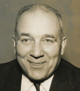
Paul Seifner
https://search.heritageburnaby.ca/link/archivedescription46221
- Repository
- City of Burnaby Archives
- Date
- 1960
- Collection/Fonds
- Columbian Newspaper collection
- Description Level
- Item
- Physical Description
- 1 photograph : b&w ; 11.5 x 10 cm
- Scope and Content
- Photograph of Paul Seifner, Burnaby councillor from 1958 to 1959.
- Repository
- City of Burnaby Archives
- Date
- 1960
- Collection/Fonds
- Columbian Newspaper collection
- Physical Description
- 1 photograph : b&w ; 11.5 x 10 cm
- Description Level
- Item
- Record No.
- 480-1109
- Access Restriction
- No restrictions
- Reproduction Restriction
- Reproduce for fair dealing purposes only
- Accession Number
- 2003-02
- Scope and Content
- Photograph of Paul Seifner, Burnaby councillor from 1958 to 1959.
- Subjects
- Officials - Alderman and Councillors
- Names
- Seifner, Paul
- Media Type
- Photograph
- Photographer
- Graphic Industries Limited
- Notes
- Title based on contents of photograph
Images

![Sidney Roofing and Paper Company, [1960] thumbnail](/media/Hpo/_Data/_Archives_Images/_Unrestricted/001/091-001.jpg?width=280)
Sidney Roofing and Paper Company
https://search.heritageburnaby.ca/link/archivedescription34676
- Repository
- City of Burnaby Archives
- Date
- [1960]
- Collection/Fonds
- Burnaby Historical Society fonds
- Description Level
- Item
- Physical Description
- 1 photograph : b&w ; 20.2 x 25.7 cm mounted on cardboard
- Scope and Content
- Aerial photograph of Sidney Roofing and Paper Company located in South Burnaby.
- Repository
- City of Burnaby Archives
- Date
- [1960]
- Collection/Fonds
- Burnaby Historical Society fonds
- Subseries
- Photographs subseries
- Physical Description
- 1 photograph : b&w ; 20.2 x 25.7 cm mounted on cardboard
- Description Level
- Item
- Record No.
- 091-001
- Access Restriction
- No restrictions
- Reproduction Restriction
- Reproduce for fair dealing purposes only
- Accession Number
- BHS2007-04
- Scope and Content
- Aerial photograph of Sidney Roofing and Paper Company located in South Burnaby.
- Subjects
- Aerial Photographs
- Buildings - Industrial
- Media Type
- Photograph
- Photographer
- Graphic Industries Limited
- Notes
- Title based on contents of photograph
- Bottom of photo has the "Sidney Products" logo and reads, "Sidney Roofing & Paper Co. Ltd."
- Printed on back of cardboard "GIL: Graphic Industries Ltd. / Vancouver's Largest Commercial Photographers / 1201 Melville St., Vancouver 1, B.C. / Phone MUtual 1-4174 File No: 4601 3"
- Annotation on back of photograph reads, "[illegible of Sid R. in Burnaby looking N/W / June 5 '58"
- Historic Neighbourhood
- Fraser Arm (Historic Neighbourhood)
- Planning Study Area
- Big Bend Area
Images
![Sidney Roofing and Paper Company, [1960] thumbnail](/media/Hpo/_Data/_Archives_Images/_Unrestricted/001/091-001.jpg)
![Sidney Roofing and Paper Company, [1960] thumbnail](/media/Hpo/_Data/_Archives_Images/_Unrestricted/001/091-003.jpg?width=280)
Sidney Roofing and Paper Company
https://search.heritageburnaby.ca/link/archivedescription34678
- Repository
- City of Burnaby Archives
- Date
- [1960]
- Collection/Fonds
- Burnaby Historical Society fonds
- Description Level
- Item
- Physical Description
- 1 photograph : b&w ; 20.2 x 25.5 cm
- Scope and Content
- Photograph of construction and construction workers at Sidney Roofing and Paper Company, South Burnaby.
- Repository
- City of Burnaby Archives
- Date
- [1960]
- Collection/Fonds
- Burnaby Historical Society fonds
- Subseries
- Photographs subseries
- Physical Description
- 1 photograph : b&w ; 20.2 x 25.5 cm
- Description Level
- Item
- Record No.
- 091-003
- Access Restriction
- No restrictions
- Reproduction Restriction
- Reproduce for fair dealing purposes only
- Accession Number
- BHS2007-04
- Scope and Content
- Photograph of construction and construction workers at Sidney Roofing and Paper Company, South Burnaby.
- Media Type
- Photograph
- Photographer
- Graphic Industries Limited
- Notes
- Title based on contents of photograph
- Bottom of photo has the "Sidney Products" logo and reads, "Sidney Roofing & Paper Co. Ltd."
- Stamped on back of photograph: "Photo by: Graphic Industries Ltd. / File No. 3205-1 / Vancouver, Canada / PAcific 4174"
- Historic Neighbourhood
- Fraser Arm (Historic Neighbourhood)
- Planning Study Area
- Big Bend Area
Images
![Sidney Roofing and Paper Company, [1960] thumbnail](/media/Hpo/_Data/_Archives_Images/_Unrestricted/001/091-003.jpg)
![Sidney Roofing and Paper Company, [1960] thumbnail](/media/Hpo/_Data/_Archives_Images/_Unrestricted/001/091-004.jpg?width=280)
Sidney Roofing and Paper Company
https://search.heritageburnaby.ca/link/archivedescription34679
- Repository
- City of Burnaby Archives
- Date
- [1960]
- Collection/Fonds
- Burnaby Historical Society fonds
- Description Level
- Item
- Physical Description
- 1 photograph : b&w ; 20.5 x 25.3 cm
- Scope and Content
- Aerial photograph of Sidney Roofing and Paper Company, South Burnaby.
- Repository
- City of Burnaby Archives
- Date
- [1960]
- Collection/Fonds
- Burnaby Historical Society fonds
- Subseries
- Photographs subseries
- Physical Description
- 1 photograph : b&w ; 20.5 x 25.3 cm
- Description Level
- Item
- Record No.
- 091-004
- Access Restriction
- No restrictions
- Reproduction Restriction
- Reproduce for fair dealing purposes only
- Accession Number
- BHS2007-04
- Scope and Content
- Aerial photograph of Sidney Roofing and Paper Company, South Burnaby.
- Media Type
- Photograph
- Photographer
- Graphic Industries Limited
- Notes
- Title based on contents of photograph
- Bottom of photo has the "Sidney Products" logo and reads, "Sidney Roofing & Paper Co. Ltd."
- Stamped on back of photograph: "Photo by: Graphic Industries Ltd. / File No. 3921-2 / Vancouver, Canada / PAcific 4174"
- Historic Neighbourhood
- Fraser Arm (Historic Neighbourhood)
- Planning Study Area
- Big Bend Area
Images
![Sidney Roofing and Paper Company, [1960] thumbnail](/media/Hpo/_Data/_Archives_Images/_Unrestricted/001/091-004.jpg)