![Survey and Subdivision plans in New Westminster District Group 1 – Burnaby
, [1861]-[1910] thumbnail](/media/hpo/_Data/_BVM_Cartographic_Material/1977/1977_0093_0019a_001.jpg?width=280)
Survey and Subdivision plans in New Westminster District Group 1 – Burnaby
https://search.heritageburnaby.ca/link/museumdescription6988
- Repository
- Burnaby Village Museum
- Date
- [1861]-[1910]
- Collection/Fonds
- Burnaby Village Museum Map collection
- Description Level
- File
- Physical Description
- 14 plans : 3 plans : black ink on paper hand col. + 7 plans : black ink on paper + 4 plans : graphite on paper mounted on 2 sides of cardboard 76 x 102 cm
- Scope and Content
- Item consists of a large board of four New Westminster District Gp 1 - subdivision plans mounted on one side and ten New Westminster District Gp 1 - subdivision plans mounted on the other side. Side A: 1. "Plan /of / Lots 166A, 166 and 167 /, Gr.1, N.W.D. / Showing Misconstructed Roads in Gree…
- Repository
- Burnaby Village Museum
- Collection/Fonds
- Burnaby Village Museum Map collection
- Description Level
- File
- Physical Description
- 14 plans : 3 plans : black ink on paper hand col. + 7 plans : black ink on paper + 4 plans : graphite on paper mounted on 2 sides of cardboard 76 x 102 cm
- Material Details
- Scales [between 1:2376 and 1:7920]
- Index number on edge of board reads: "19"
- Scope and Content
- Item consists of a large board of four New Westminster District Gp 1 - subdivision plans mounted on one side and ten New Westminster District Gp 1 - subdivision plans mounted on the other side. Side A: 1. "Plan /of / Lots 166A, 166 and 167 /, Gr.1, N.W.D. / Showing Misconstructed Roads in Green / 5 chs = 1 in.". (plan is drawn in black ink and hand coloured in red, green and orange ink). A section in the centre of the plan is coloured in red ink and identified as "C.S. Richmond" running from the North Arm of Fraser River to Wiggins Road and divided by "New Wiggins Rd. (as gazetted)" (coloured in orange ink) and two"Constructed Road(s)" (coloured in green ink). Plan is initialed by: "RB" [sic] (in blue pencil crayon) 2. Plan of / Subdivision of / Lot 166 / Group One / New Westminster District / Scale 4 chs = 1 in. / Map No 524". Plan is drawn in graphite and signed by "Surrig [sic] Welhams [sic] / P.L.S." Plan is initialed by: "RB" [sic] (in blue pencil crayon) 3. Plan of "Survey / of Highway / For / Burnaby Council / in / Lots 13 _14 / Group One / Scale 4 chs = 1 in." Signed by "Albert J. Hill, P.L.S." Caribou Street and Caribou Road run through the centre of the plan. Plan is stamped: "Albert J. Hill, Civil Engineer / and / Provincial Land Surveyor, / New Westminster, / B.C.". Plan is initialed by: "RB" [sic] (in blue pencil crayon) 4. A Plan of Lots 166A, 166 and 167, Group One, New Westminster District (drawn in graphite). A section in the centre of the plan is identified as "C.S. Richmond" running from the North Arm of Fraser River and divided by "New Wiggins Rd. (as gazetted)" and two "Constructed Road(s)". Plan is initialed by: "RB" [sic] (in blue pencil crayon) Side B: 1. Small plan drawn in black ink (no title) identifying lots north of the "North Arm" of the Fraser River. Lots identified include: Lot 99, Lot 98, Lot 157, Lot 158, Lot 163, Lot 162, Lot 159, Lot 163, Lot 162, Lot 165, Lot 166A, Lot 155B, Lot 155A and Lot 159. "Scale 40 chains to one inch" . Plan is initialed by: "RB" [sic] (in blue pencil crayon) (Geographic location: Burnaby) 2. Small plan drawn in black ink (no title) identifying lots north of the North Arm of the Fraser River as "Lots 155, 155A, 155B, 155C, 162, 163, 164, 165, 166A and 167". Plan is initialed by: "RB" [sic] (in blue pencil crayon) (Geographic location: Burnaby) 3. Small plan drawn in black ink (no title) which identifies "Lot 151 / Reserve/ for / Race Course"; "Reserve / 64 A / L. 152 G.1"; and other Lots: 32, 33, 34, 35, 36, 38, 39. The plan is signed "Surveyor G.Turn [sic] July / 61 / from Vol 40 R.L. notes [sic]" Plan is stamped: "Albert J. Hill, Civil Engineer / and / Provincial Land Surveyor, / New Westminster, / B.C." Plan is initialed by: "RB" [sic] (in blue pencil crayon) (Geographic location: Burnaby) 4. Small plan drawn in black in with faded red colouring on centre lot identified as "Lot 34" running north from "Vancouver Road" . Plan is stamped: "Albert J. Hill, Civil Engineer / and / Provincial Land Surveyor, / New Westminster, / B.C." Plan is initialed by: "RB" [sic] (in blue pencil crayon) (Geographic location: Burnaby) 5. Plan drawn in graphite and identified as "Lot 98, Gr.1," along with the intials "RB" [sic] (both are handwritten in blue crayon pencil on top of plan) The B.C.E.Railway is identified running through the plan along with Jubilee Road and Royal Oak Road. The plan is signed with the name "Wm. Murray" and the Plan is stamped: "Albert J. Hill, Civil Engineer / and / Provincial Land Surveyor, / New Westminster, / B.C.". (Geographic location: Burnaby) 6. Plan drawn in graphite identified as "Port Lot 13, Gr.1" along with the intials "RB" [sic] (both are handwritten in blue crayon pencil on top of plan) Plan is stamped: "Albert J. Hill, Civil Engineer / and / Provincial Land Surveyor, / New Westminster, / B.C.". (Geographic location: Burnaby) 7.Plan drawn in black ink and identified as "Lot 98 G.1" along with the intials "RB" [sic] (both are handwritten in blue crayon pencil on top of plan). A "Road Reservation" is identified running north between "Electric Tramway" and connecting with "Royal Oak Road". Plan is stamped: "Albert J. Hill, Civil Engineer / and / Provincial Land Surveyor, / New Westminster, / B.C." (Geographic location: Burnaby) 8. Plan drawn in black ink and divided into two sections, the upper plan is identified as "Portion / Lots 100 / area / 101, Gr.1" and the lower plan is identified as "Portion L. 3 G. 1" along with the intials "RB" [sic] (these identifiers are handwritten in blue crayon pencil on top of the plan). Portions of Lot 100 and Lot 101 are each divided into 6 sections and the Portion of Lot 3 plan is divided into 24 sections. The plan includes a note in black ink that reads: " Received from Wm Fromme [sic] / from Wm. Trapp / Nov. 28, 1895 / A. J. T...[sic]". (Geographic location: Burnaby) 9. Plan drawn in black ink (no title) identifying soil, buildings and geographic features in southern Burnaby. The plan is bordered by "New Westminster City" (Tenth Avenue and DL 172) to the south east and DL 173 to the south, DL 158 to the west and the B.C.E. Tramway to the north. Plan includes District Lots: 155A, 158, 159, 171, 160, 53 and 95 and identifies soil, marshland and ravines throughout. Plan identifies the following features: a "Team Road" running through Lots 158 and 159 along with "Fair Orchard Soil / Even Surface Throughout / No Ravines", "Gravel and Shingle" (bottom of Lot 158), "North Arm Road" crossing "Byrne Road" and connecting with "Power House Road" which runs north to connect with "Highland Park Station" and the B.C.E. Tramway, "Power Ho" in the northeast corner of DL 160, a "Brook" connected with a "Deep Ravine" running between DL 53, DL 95 and DL 160 along with "Good Soil" and "Fair Orchard Soil" identified nearby in DL 95. Scale is identified as "10 chs = 1 in." Plan is stamped: "Albert J. Hill, Civil Engineer / and / Provincial Land Surveyor, / New Westminster, / B.C." Plan is initialed by: "RB" [sic] (in blue pencil crayon) (Geographic location: Burnaby) 10. Plan drawn in black ink (no title) with Burnaby Lake and Deer Lake at the centre. The plan is bordered by the following District Lots identified as: 117, 118 and 68 to the west, Lots 80, 79 and 85 to the southwest, Lots 11, 13, and 1 (City of New Westminster) to the south east, the North Road boundary to the east and Lots 8, 56, 57, 59, and 136 to the North. The lower right hand corner of the plan has a small inset which reads: "Burnaby Lake" and "Page 19 R.B. Notes". Plan is initialed by: "RB" [sic] (in blue pencil crayon) (Geographic location: Burnaby)
- Creator
- Hill, Albert James
- Accession Code
- HV977.93.19
- Access Restriction
- No restrictions
- Reproduction Restriction
- No known restrictions
- Date
- [1861]-[1910]
- Media Type
- Cartographic Material
- Scan Resolution
- 300
- Scale
- 72
- Notes
- Title based on contents of file
- Scale is measured in chains. (One chain equals 792 inches)
- The term "Lot" can also refer to a "District Lot”
- Some plans are stamped: "Albert J. Hill, Civil Engineer / and / Provincial Land Surveyor, / New Westminster, / B.C." and intialed: "RB" [sic]
Images
![Survey and Subdivision plans in New Westminster District Group 1 – Burnaby
, [1861]-[1910] thumbnail](/media/hpo/_Data/_BVM_Cartographic_Material/1977/1977_0093_0019a_001.jpg)

![Survey and Subdivision plans in New Westminster District Group 1 – Burnaby, Port Moody, [1862-1908] thumbnail](/media/hpo/_Data/_BVM_Cartographic_Material/1977/1977_0093_0026a_001.jpg?width=280)
Survey and Subdivision plans in New Westminster District Group 1 – Burnaby, Port Moody
https://search.heritageburnaby.ca/link/museumdescription6995
- Repository
- Burnaby Village Museum
- Date
- [1862-1908]
- Collection/Fonds
- Burnaby Village Museum Map collection
- Description Level
- File
- Physical Description
- 9 plans : 6 plans : black ink on paper ; 57 x 36.5 cm or smaller + 1 plan : black ink and grahite on paper ; 46.5 x 49 cm + 1 plan : blueprint on paper ; 15.5 x 19.5 cm + cm + 1 plan : graphite on paper ; 25 x 17 cm ; mounted on both sides of board 76 x 102 cm
- Scope and Content
- Item consists of a large board of four New Westminster District subdivision plans mounted on one side and five New Westminster District subdivision plans mounted on the other side. Side A: 1. "Plan / of Subdivision / of a Portion / of / Lot 87 / Group One / New Westminster District / Scale 4 chs…
- Repository
- Burnaby Village Museum
- Collection/Fonds
- Burnaby Village Museum Map collection
- Description Level
- File
- Physical Description
- 9 plans : 6 plans : black ink on paper ; 57 x 36.5 cm or smaller + 1 plan : black ink and grahite on paper ; 46.5 x 49 cm + 1 plan : blueprint on paper ; 15.5 x 19.5 cm + cm + 1 plan : graphite on paper ; 25 x 17 cm ; mounted on both sides of board 76 x 102 cm
- Material Details
- Scales [between 1:792 and 1:3600]
- Index number on edge of board reads: "26"
- Scope and Content
- Item consists of a large board of four New Westminster District subdivision plans mounted on one side and five New Westminster District subdivision plans mounted on the other side. Side A: 1. "Plan / of Subdivision / of a Portion / of / Lot 87 / Group One / New Westminster District / Scale 4 chs = 1 in". Plan is stamped: "Albert J. Hill, Civil Engineer / and / Provincial Land Surveyor, / New Westminster, / B.C." and intialed by: "RB" [sic] (in blue pencil crayon). Names two of the subdivisons of District Lot 87 are identified as, "L.E. Sprott" and "John Ledger". (Geographic location: Burnaby) 2. "Plan of Subdivision / of / Portions of / Lot 136, 131 and Lots 44 and 78 Gr.1 / New Westminster District / Scale 300 ft = 1 inch". Annotation above title reads: "No. 901 / Deposited in Land Registry Office / New Westminster / Aug. 19th 1905 / Charles S. Keith D. Reg." Annotations and signatures at bottom of plan read: "I, William Nelson Draper, / W.H.R. Collister / Charles E. Perkins / E.B. Morgan / make / Surveys / correct / representation / upon / the / Land Registry Act / (sgd) W.N. Draper, P.L.S.". Plan includes a handwritten title: "Lots 136, 131, 44 & 78" and is initialed: "RB" [sic] (in blue pencil crayon) (Geographic location: Burnaby) 3. "Survey / of / a Portion / of / Lot 95, Gr.1 / Scale 1 ch = 1in." Plan is stamped: "Albert J. Hill, Civil Engineer / and / Provincial Land Surveyor, / New Westminster, / B.C." and is initialed : "RB" [sic] (in blue pencil crayon) (Geographic location: Burnaby) 4. Blueprint plan of "Lot 396. Group One." with Scale : 3 chs = 1 in. A two acre portion of District Lot 396 is filled in with red ink." Plan is signed by "Albert J. Hill / B.C.L.S." (Geographic location: Port Moody) Side B: 1. Plan titled "District Lot 92 / Burnaby / Municipality / for sale by / Mahon / McFarland & / Mahon Ltd. / Vancouver, B.C. / Scale : 4 chains to one inch". District Lot 92 is subdivided into 161 lots and identifies roads: Norwich Road, Pole Line Road, Oakland Road, Stanley Road, Burford Road, Dalhousie Road, Brantford Road, Colborne Road, Roberts Road, Vancouver & Westminster Road, B.C. Electric Railway, Gilley Stn. and Burnaby (Power House). The bottom of the plan reads: "G.S. Dawson, P.LS. Vancouver, B.C." (Geographic location: Burnaby) 2. "Plan / of Subdivision / of a Portion / of / Lot 29 / Group 1 / New Westminster District / Scale 2 chs = 1 in". Plan is stamped: "Albert J. Hill, Civil Engineer / and / Provincial Land Surveyor, / New Westminster, / B.C." and is initialed by: "RB" [sic] (in blue pencil crayon) (Geographic location: Burnaby) 3. Small handrawn plan (no title) identifying "Lot 84 / Hydes, Claim" at the centre surrounded by lots and features identified as: "Lot 85", "Lot 93", "Lot 94", "Lot 32", "Lot 82", "Lot 83", "Lot 79", "swamp" and a "Small Lake" (Burnaby Lake). Identifying marks in the right corner of the plan read: "Page 13 / Surveyed by G. Turner / May 62". Plan also includes surveyor's bearing measurements and trails to "Small Lake" (Burnaby Lake). (Geographic location: Burnaby) 4. Untitled plan showing District Lots west of North Road and north of Burnaby Lake including: Lots 2, 4, 6, 8, 15, 10, 56, 148, 57, 58, 40. and Lots 3, 5, 7 east of North Road (Coquitlam). Lots in Burnaby are identifed for timber including: "Heavily Timbered" (Lot 57), " "Some Fir and Cedar" (Lot 40), "Splendid Fir and Cedar" (Lot 143), "Heavy Fir etc" (Lots 143 and 148), " "Fine Cedar" (Lot 15), "Rough Light Timber" (Lot 56). Other features identified at the lower portion of the plan include "Burnaby Lake" and "Brunette River". (Geographic location: Burnaby) 5. Untitled plan drawn in graphite showing sections of District Lot 85 south of Burnaby Lake and north of Hazsard Road. Plan is signed: "Albert J. Hill / B.C.L.S." and dated "12/26/08". Plan is initialed by: "RB" [sic] (in blue pencil crayon) (Geographic location: Burnaby)
- Publisher
- Mahon, McFarland & Mahon Ltd
- Accession Code
- HV977.93.26
- Access Restriction
- No restrictions
- Reproduction Restriction
- No known restrictions
- Date
- [1862-1908]
- Media Type
- Cartographic Material
- Historic Neighbourhood
- Burnaby Lake (Historic Neighbourhood)
- Burquitlam (Historic Neighbourhood)
- Planning Study Area
- Burnaby Lake Area
- Scan Resolution
- 300
- Scale
- 72
- Notes
- Title based on contents of file
- Scale is measured in chains and feet. (One chain equals 792 inches)
- The term "Lot" can also refer to a "District Lot”
Images
![Survey and Subdivision plans in New Westminster District Group 1 – Burnaby, Port Moody, [1862-1908] thumbnail](/media/hpo/_Data/_BVM_Cartographic_Material/1977/1977_0093_0026a_001.jpg)


Love family correspondence
https://search.heritageburnaby.ca/link/museumdescription10087
- Repository
- Burnaby Village Museum
- Date
- 1880-1911
- Collection/Fonds
- Love family fonds
- Description Level
- File
- Physical Description
- 1 folder of textual records
- Scope and Content
- File consists of a series of personal letters from family members in England to Jesse and Martha Love., including; Sept 22, 1880- to Jesse and Martha Love from Jesse's mother Elizabeth Love; June 7th, 1880- to Jesse from his mother Elizabeth Love; June 9th, 1880- Letter to Jesse Love from his moth…
- Repository
- Burnaby Village Museum
- Collection/Fonds
- Love family fonds
- Description Level
- File
- Physical Description
- 1 folder of textual records
- Scope and Content
- File consists of a series of personal letters from family members in England to Jesse and Martha Love., including; Sept 22, 1880- to Jesse and Martha Love from Jesse's mother Elizabeth Love; June 7th, 1880- to Jesse from his mother Elizabeth Love; June 9th, 1880- Letter to Jesse Love from his mother Elizabeth Love; April 26, 1880 - to Jesse and Martha Love from Jesse's mother Elizabeth Love; May 21, 1881 -To Jesse Love from one of his sisters regarding his mother's death; Jan 18, 1892 - Swindon - to Jesse from his sister, informing him of his father's death; 8th Jan 1906 - to Jesse from his sister,Torie Love; 28 Oct 1910 - to Martha Love from Jesse's sister Torie Love; 27th, (month?) 1910 - to Jesse Love and one of his sisters from Jesse's sister Torie; 14th July 1911 - Letter to Jesse and Martha Love from Jesse's sister Torie; an envelope - addressed to "Mr. Jesse Love / East Burnaby, New Westminster / B.C." postmarked "Jan __ 05 / SWINDON STATION" (does not appear to relate to any of the dates of the letters) and a small evelope addressed to : "Mrs Love / Burnaby".
- History
- See extensive history of Love Family and Love farmhouse located at Burnaby Village Museum.
- Accession Code
- BV012.31.19
- Access Restriction
- No restrictions
- Reproduction Restriction
- No known restrictions
- Date
- 1880-1911
- Media Type
- Textual Record
- Scan Resolution
- 300
- Scan Date
- Feb-02-2012
- Scale
- 96
- Notes
- Title based on content of file
Images

![Subdivision plans in New Westminster District Group 1 – Burnaby
, [1882-1910] thumbnail](/media/hpo/_Data/_BVM_Cartographic_Material/1977/1977_0093_0013a_001.jpg?width=280)
Subdivision plans in New Westminster District Group 1 – Burnaby
https://search.heritageburnaby.ca/link/museumdescription6982
- Repository
- Burnaby Village Museum
- Date
- [1882-1910]
- Collection/Fonds
- Burnaby Village Museum Map collection
- Description Level
- File
- Physical Description
- 4 plans : blueprint on paper mounted on 2 sides of cardboard 76 x 102 cm
- Scope and Content
- Item consists of a large board of two New Westminster District Gp 1 - subdivision plans mounted on one side and two New Westminster District Gp 1 - subdivision plans mounted on the other side. Side A: 1. Blueprint "Plan / of the / Subdivision / of / Lot 98 / G.1, N.W.D. / Scale 4 chs = 1 in. / …
- Repository
- Burnaby Village Museum
- Collection/Fonds
- Burnaby Village Museum Map collection
- Description Level
- File
- Physical Description
- 4 plans : blueprint on paper mounted on 2 sides of cardboard 76 x 102 cm
- Material Details
- Scales [between 1:1584 and 1:3168]
- Index number on edge of board reads: "13"
- Scope and Content
- Item consists of a large board of two New Westminster District Gp 1 - subdivision plans mounted on one side and two New Westminster District Gp 1 - subdivision plans mounted on the other side. Side A: 1. Blueprint "Plan / of the / Subdivision / of / Lot 98 / G.1, N.W.D. / Scale 4 chs = 1 in. / Map No 573" (Geographic location: Burnaby) 2. Blueprint "Plan / of Subdivision of / Lot 157 / Gr.1, New. West. Dist. / Scale 3 chs = 1 in. / Map No. 612". (Geographic location: Burnaby) Side B: 1. Blueprint "Plan / of Subdivision / of a Portion of / Lot 90 / Group One / New Westminster Dist. / Scale 2 chs = 1 in. / Map No. 555". Plan is signed by "Jno Strathern [sic]_P.L.S."n (Geographic location: Burnaby) 2. Blueprint "Subdivision of Lot 31, Group 1. / New Westminster District / As Amended by Order of Court / 1st Sept. 1882 and Numbered 847 / Scale 4 chs = 1in. / Map No 80" (Geographic location: Burnaby)
- Creator
- Stathern, John
- Accession Code
- HV977.93.13
- Access Restriction
- No restrictions
- Reproduction Restriction
- No known restrictions
- Date
- [1882-1910]
- Media Type
- Cartographic Material
- Historic Neighbourhood
- Alta Vista (Historic Neighbourhood)
- Planning Study Area
- Richmond Park Area
- Lakeview-Mayfield Area
- Scan Resolution
- 300
- Scale
- 72
- Notes
- Title based on contents of file
- Scale is measured in chains. (One chain equals 792 inches)
- The term "Lot" can also refer to a "District Lot”
Images
![Subdivision plans in New Westminster District Group 1 – Burnaby
, [1882-1910] thumbnail](/media/hpo/_Data/_BVM_Cartographic_Material/1977/1977_0093_0013a_001.jpg)

![Subdivision plans in New Westminster District Group 1 – Burnaby
, [1890-1910] thumbnail](/media/hpo/_Data/_BVM_Cartographic_Material/1977/1977_0093_0014a_001.jpg?width=280)
Subdivision plans in New Westminster District Group 1 – Burnaby
https://search.heritageburnaby.ca/link/museumdescription6983
- Repository
- Burnaby Village Museum
- Date
- [1890-1910]
- Collection/Fonds
- Burnaby Village Museum Map collection
- Description Level
- File
- Physical Description
- 4 plans : blueprint ink on paper mounted on 2 sides of cardboard 76 x 102 cm
- Scope and Content
- Item consists of a large board of two New Westminster District Gp 1 - subdivision plans mounted on one side and two New Westminster District Gp 1 - subdivision plans mounted on the other side. Side A: 1. Blueprint "Plan of / Subdivision of Lot No. 69 / Group One / New Westminster District / Pro…
- Repository
- Burnaby Village Museum
- Collection/Fonds
- Burnaby Village Museum Map collection
- Description Level
- File
- Physical Description
- 4 plans : blueprint ink on paper mounted on 2 sides of cardboard 76 x 102 cm
- Material Details
- Scales [between 1:1584 and 1:3168]
- Index number on edge of board reads: "14"
- Scope and Content
- Item consists of a large board of two New Westminster District Gp 1 - subdivision plans mounted on one side and two New Westminster District Gp 1 - subdivision plans mounted on the other side. Side A: 1. Blueprint "Plan of / Subdivision of Lot No. 69 / Group One / New Westminster District / Property of Ernest Buse, Esq. / Scale 3 chs = 1 in. / Map No 290". Plan is signed by "Garden, Hermon and Burwell, Dom. Land Surveyor" (Geographic location: Burnaby) 2. Blueprint "Plan / of Subdivision / of Lots 1-19, 36-53 and 69-75 inclusive / in the Subdivision / of / Lot 30 / Group One / New Westminster District / Scale 2 chs = 1 in. Map No 631". Plan is signed by "Jno [sic] Strathern [sic] P.L.S." Names and Lot numbers are handwritten in red pencil in sections along Douglas Road and read: "20 - F / 21 - Fitherstruhaul [sic] / 22 - J.S. Craig / 23 - McGill & Dill / 24 / 25 / 26 / 27 / 28 - School / 29 - School / 30 - D. McDownall / 31 - W.J. Troloow [sic] / 32 - N.C. Nelson / 33 - _[sic] McGill / 34 - T.S.[sic] Craig / 35" (Geographic location: Burnaby) Side B: 1.Blueprint "Plan / of Subdivision / of Centre Portion / of Lot 28 / Group One / New Westminster District / Scale 200' = 1" / Map No 627". Plan is signed by "Jno Strathern / P.L.S." (Geographic location: Burnaby) 2. Blueprint "Plan / of Subdivision / of N.1/2 Lot 100 and S.1/2 Lot 101, / Group One / New Westminster District, BC / Scale 4 chs = 1 in." (Geographic location: Burnaby)
- Names
- Strathern, John
- Accession Code
- HV977.93.14
- Access Restriction
- No restrictions
- Reproduction Restriction
- No known restrictions
- Date
- [1890-1910]
- Media Type
- Cartographic Material
- Historic Neighbourhood
- Broadview (Historic Neighbourhood)
- East Burnaby (Historic Neighbourhood)
- Planning Study Area
- Cascade-Schou Area
- West Central Valley Area
- Second Street Area
- Lake City Area
- Scan Resolution
- 300
- Scale
- 72
- Notes
- Title based on contents of file
- Scale is measured in chains and feet. (One chain equals 792 inches)
- The term "Lot" can also refer to a "District Lot”
Images
![Subdivision plans in New Westminster District Group 1 – Burnaby
, [1890-1910] thumbnail](/media/hpo/_Data/_BVM_Cartographic_Material/1977/1977_0093_0014a_001.jpg)


Subdivision plans in New Westminster District Group 1 – Burnaby, Vancouver and map - Canada Department of Mines
https://search.heritageburnaby.ca/link/museumdescription6994
- Repository
- Burnaby Village Museum
- Date
- 1890-1909
- Collection/Fonds
- Burnaby Village Museum Map collection
- Description Level
- File
- Physical Description
- 1 plan : graphite on paper + 2 plans : black ink on paper + 1 map : col. on paper mounted on 2 sides of cardboard 76 x 102 cm
- Scope and Content
- Item consists of a large board with one New Westminster District subdivision plan mounted on one side and two New Westminster District subdivision plans and one colour map mounted on the other side. Side A: 1. "Plan / of Subdivision of / Blocks 2, 3, 4, 5, 6 / Lot 77 / Group 1 / New Westminster D…
- Repository
- Burnaby Village Museum
- Collection/Fonds
- Burnaby Village Museum Map collection
- Description Level
- File
- Physical Description
- 1 plan : graphite on paper + 2 plans : black ink on paper + 1 map : col. on paper mounted on 2 sides of cardboard 76 x 102 cm
- Material Details
- Scales 1:720 and 1:1200 and 1:.00001578
- Scope and Content
- Item consists of a large board with one New Westminster District subdivision plan mounted on one side and two New Westminster District subdivision plans and one colour map mounted on the other side. Side A: 1. "Plan / of Subdivision of / Blocks 2, 3, 4, 5, 6 / Lot 77 / Group 1 / New Westminster District / BC. / Scale 100 feet = 1 inch", "Deposited 8th day / of April 1890 / Mowileg [sic] / Dist. Regt". Plan is drawn in graphite with annotations: "AB_Parts_lettered_are_lots_in / the_different_subdivisions" / "Owners: / James E. Hall / P.S.Cabilan [sic] by his attorney Joseph Hall / Joseph Hall / Eliza J. Shannon / John Harrison"; "This plan is correct and is prepared under the / provisions of the Land Registry Act" ; signed by: "Gordon Herman & Burwell / Dominion & Provincial Land Surveryors / Vancouver March 19th/90" . Plan is initialed by: "RB" [sic] (in blue pencil crayon) and measures: 99.5 x 65 cm (Geographic location: Burnaby) Side B: 1. Map titled "Canada / Department of Mines / Geological Survey Branch" / "Hon.W Templeton, Minister / A.P. Low, Deputy Minister / R.W. Brock, Acting Director", Vol. XXXI, Plate I / Compiled under the direction of / James White, F.R.G.S. Geographer /Dep. of Interior". Note above map reads: "To illustrate Mr. James Barrowman's report as Delegate at the Excursion - meeting of the Canadian Mining Institute", "The instiitution of Mining Engineers / Transactions 1908 - 1909", "The Mining Institute of Scotland / Transactions 1908-1909". Map identifies minerals and includes a Legend and Scale: 100 miles = 1 inch 2. "Plan / of Subdivision of / Lot 4 / of Subdivision of / Lot 87. Gr. 1 / New Westminster District / Scale 60' = 1in." Plan is initialed by: "RB" [sic] along with a note "also Board / 48" (in blue pencil crayon) (Geographic location: Burnaby) 3. Plan of "Lot 335 / G. 1" west of Boundary Road and north of River Road - Vancouver. (Geographic location: Vancouver)
- Publisher
- The Mining Institute of Scotland
- Geographic Access
- Vancouver
- Accession Code
- HV977.93.25
- Access Restriction
- No restrictions
- Reproduction Restriction
- No known restrictions
- Date
- 1890-1909
- Media Type
- Cartographic Material
- Scan Resolution
- 300
- Scale
- 72
- Notes
- Title based on contents of file
- Scale is measured in feet and miles.
- The term "Lot" often refers to "District Lot"
Images


![Subdivision plans in New Westminster District Group 1 – Burnaby
, [1891-1910] thumbnail](/media/hpo/_Data/_BVM_Cartographic_Material/1977/1977_0093_0015a_001.jpg?width=280)
Subdivision plans in New Westminster District Group 1 – Burnaby
https://search.heritageburnaby.ca/link/museumdescription6984
- Repository
- Burnaby Village Museum
- Date
- [1891-1910]
- Collection/Fonds
- Burnaby Village Museum Map collection
- Description Level
- File
- Physical Description
- 4 plans : blueprint ink on paper mounted on 2 sides of cardboard 76 x 102 cm
- Scope and Content
- Item consists of a large board of two New Westminster District Gp 1 - subdivision plans mounted on one side and two New Westminster District Gp 1 - subdivision plans mounted on the other side. Side A: 1. Blueprint "Plan / of Subdivision / of / Lot 29 / Group One / New Westminster District / Scal…
- Repository
- Burnaby Village Museum
- Collection/Fonds
- Burnaby Village Museum Map collection
- Description Level
- File
- Physical Description
- 4 plans : blueprint ink on paper mounted on 2 sides of cardboard 76 x 102 cm
- Material Details
- Scales [between 1:600 and 1:7920]
- Index number on edge of board reads: "15"
- Scope and Content
- Item consists of a large board of two New Westminster District Gp 1 - subdivision plans mounted on one side and two New Westminster District Gp 1 - subdivision plans mounted on the other side. Side A: 1. Blueprint "Plan / of Subdivision / of / Lot 29 / Group One / New Westminster District / Scale 4 chs = 1 in. / Map No 564, Depostd '91". "Reichenbach", dep. Aug. 1891. (Geographic location: Burnaby) 2. Blueprint "Plan / of Subdivision / of / Lot 93 / Group One / New Westminster District / Scale 4 chs = 1 in. / Map No 284". (Geographic location: Burnaby) Side B: 1. Blueprint "Plan / of Subdivision / of a Portion / of / [Lot A of ] Lot 29 / Group One / New Westminster District / Scale 50 ' = 1"" Plan is bordered by Douglas Road to the east, False Creek Trail to the south and Lot 30 to the north. (Geographic location: Burnaby) 2. Blueprint "Plan / of Central Park / and Vicinity / Scale 10 chs = 1 in." (Geographic location: Burnaby)
- Accession Code
- HV977.93.15
- Access Restriction
- No restrictions
- Reproduction Restriction
- No known restrictions
- Date
- [1891-1910]
- Media Type
- Cartographic Material
- Historic Neighbourhood
- Edmonds (Historic Neighbourhood)
- Planning Study Area
- Edmonds Area
- Scan Resolution
- 300
- Scale
- 72
- Notes
- Title based on contents of file
- Scale is measured in chains and feet. (One chain equals 792 inches)
- The term "Lot" can also refer to a "District Lot”
Images
![Subdivision plans in New Westminster District Group 1 – Burnaby
, [1891-1910] thumbnail](/media/hpo/_Data/_BVM_Cartographic_Material/1977/1977_0093_0015a_001.jpg)

![Survey and Subdivision plans in New Westminster District Group 1 – Burnaby
, [1892-1908] thumbnail](/media/hpo/_Data/_BVM_Cartographic_Material/1977/1977_0093_0020a_001.jpg?width=280)
Survey and Subdivision plans in New Westminster District Group 1 – Burnaby
https://search.heritageburnaby.ca/link/museumdescription6989
- Repository
- Burnaby Village Museum
- Date
- [1892-1908]
- Collection/Fonds
- Burnaby Village Museum Map collection
- Description Level
- File
- Physical Description
- 12 plans : 6 plans : black ink on paper + 6 plans : graphite on paper mounted on 2 sides of cardboard 76 x 102 cm
- Scope and Content
- Item consists of a large board of six New Westminster District Gp 1 - subdivision plans mounted on one side and three New Westminster District Gp 1 - subdivision plans mounted on the other side. Side A: 1. Plan drawn in graphite with markings "Plan 535" "Scale 3 chs = 1 in." Plan appears to ext…
- Repository
- Burnaby Village Museum
- Collection/Fonds
- Burnaby Village Museum Map collection
- Description Level
- File
- Physical Description
- 12 plans : 6 plans : black ink on paper + 6 plans : graphite on paper mounted on 2 sides of cardboard 76 x 102 cm
- Material Details
- Scales [between 1:240 and 1:7920]
- Index number on edge of board reads: "20"
- Scope and Content
- Item consists of a large board of six New Westminster District Gp 1 - subdivision plans mounted on one side and three New Westminster District Gp 1 - subdivision plans mounted on the other side. Side A: 1. Plan drawn in graphite with markings "Plan 535" "Scale 3 chs = 1 in." Plan appears to extend onto another piece of paper with a title "Lo [sic] 506" ans "Scale 2 chs = 1 in." Plan is stamped: "Albert J. Hill, Civil Engineer / and / Provincial Land Surveyor, / New Westminster, / B.C." (Geographic location: Burnaby) 2. Plan of "Douglas Road" (written at top in blue pencil) and "Plan 642 / Reg. Apr. 8 1892 / ....Lots / 3 & 4 Bl. I...[sic]" (written in graphite). Road runs through Lots 29, 28, 30, 90 and 91. Note in red ink at bottom of plan reads: "Sketch plans as sent to Council / Aug. 28_1893 / ..." Plan is stamped: "Albert J. Hill, Civil Engineer / and / Provincial Land Surveyor, / New Westminster, / B.C." (Geographic location: Burnaby) 3. Plan drawn in graphite identified with markings "L.9 in / L. 88" "Scale 3 chs = 1 in. / Albert J. Hill / B.C.L.S. / 11/3/08" (Geographic location: Burnaby) 4. Plan in black ink identified as "No.2" / Lot 101 & 100 / Gr.1" / Lot 3 Gr. 1" (handwritten in blue pencil) with "Scale : 2 Inches = 1 Mile". Plan is stamped: "Albert J. Hill, Civil Engineer / and / Provincial Land Surveyor, / New Westminster, / B.C." (Geographic location: Burnaby) 5. Plan in black ink identified as "Sub. L. 28 and 29 of / Lot 35, G - 1" (handwritten in blue pencil) "Scale 100' = 1 in." (Geographic location: Burnaby) 6. Plan drawn in graphite with markings "Lot 165 Gr.1" (handwritten in blue pencil) "Scale 10 chs = 1 in. / Albert J. Hill / B.C.L.S." (Geographic location: Burnaby) 7. "Plan / of Subdivision / of / Subdivision of Lot 10 [sic] / of Lot 53 / Group One / New Westminster Dist. / Scale 1 chs = 1 inc." (drawn and written in graphite) Plan is stamped: "Albert J. Hill, Civil Engineer / and / Provincial Land Surveyor, / New Westminster, / B.C." (Geographic location: Burnaby) Side B: 1. "Plan / of Subdivision / of / Lots 10 and 11, / in the Subdivision / of / Lot 156 Gr.1 / New Westminster District / Scale 100' = 1 "" (drawn and written in graphite) (Geographic location: Burnaby) 2. "Plan / of Subdivision / of a Portion / of / Lot 95 / Group One / New Westminster District / Scale 3 chs = 1 in." (drawn in graphite and black ink) Plan is stamped: "Albert J. Hill, Civil Engineer / and / Provincial Land Surveyor, / New Westminster, / B.C." (Geographic location: Burnaby) 3. Plan drawn in graphite and identified as "Lot 98, Gr.1" (handwritten in blue pencil). Plan identifies a "Road Reservation", "Royal Oak Road" and "Electric Tramway" and "Lot 94" to the north of "Lot 98" (Geographic location: Burnaby) 4. Plan drawn in graphite and identified as "Lot 25, Gr.1" (handwritten in blue pencil) Lot 25 is identified as "Love" "Scale 7 chs = 1 in. / Albert J. Hill B.C.L.S." Plan is dated "24/7/07" Plan is stamped: "Albert J. Hill, Civil Engineer / and / Provincial Land Surveyor, / New Westminster, / B.C." (Geographic location: Burnaby) 5. Profile plan in black ink with marking "Douglas Road" and intials "RGS" [sic] (handwritten in blue pencil) "City Boundary / Hastings Road / Scale Hor 200' = 1" / Vert 20' = 1"" Plan is also marked in red pencil and reads: "Please / See other side". Plan is stamped: "Albert J. Hill, Civil Engineer / and / Provincial Land Surveyor, / New Westminster, / B.C." (Geographic location: Burnaby) 6. Plan of "Profile / on Tramway Track / New Vancouver Road / Scales Hor 200 ft = 1 inch / Vert 20 ft = 1 inch" (Geographic location: Burnaby)
- Creator
- Hill, Albert James
- Accession Code
- HV977.93.20
- Access Restriction
- No restrictions
- Reproduction Restriction
- No known restrictions
- Date
- [1892-1908]
- Media Type
- Cartographic Material
- Scan Resolution
- 300
- Scale
- 72
- Notes
- Title based on contents of file
- Scale is measured in chains and feet. (One chain equals 792 inches)
- The term "Lot" can also refer to a "District Lot”
Images
![Survey and Subdivision plans in New Westminster District Group 1 – Burnaby
, [1892-1908] thumbnail](/media/hpo/_Data/_BVM_Cartographic_Material/1977/1977_0093_0020a_001.jpg)


Florence Hart Godwin photograph album
https://search.heritageburnaby.ca/link/museumdescription3049
- Repository
- Burnaby Village Museum
- Date
- 1893-1923 (date of original), copied 1976
- Collection/Fonds
- Florence Hart Godwin fonds
- Description Level
- File
- Physical Description
- 1 album (29 photographs: b&w negatives ; 35 mm)
- Scope and Content
- File consists of a photographic reproduction of a twenty nine page photograph album that was created by Florence Hart Godwin. The first page of the album reads "Florence, with Grandma's and Auntie Felicia's best love, Xmas 1910" and the other pages contain photographs. The album was given to Flore…
- Repository
- Burnaby Village Museum
- Collection/Fonds
- Florence Hart Godwin fonds
- Description Level
- File
- Physical Description
- 1 album (29 photographs: b&w negatives ; 35 mm)
- Scope and Content
- File consists of a photographic reproduction of a twenty nine page photograph album that was created by Florence Hart Godwin. The first page of the album reads "Florence, with Grandma's and Auntie Felicia's best love, Xmas 1910" and the other pages contain photographs. The album was given to Florence Hart for Christmas in 1910, by her grandmother Jane Chapman (nee Isbell) and her Aunt Felicia Chapman. Album contains photographs of the Alice and Frederick J. Hart and Chapman families, including childhood photographs of the five Hart children, Kingsley, Florence, Fredricka, Edwyna and Jack; the Hart family at their home in New Westminster and at "Avalon" their summer residence and home on Deer Lake.
- Names
- Godwin, Florence Hart
- Accession Code
- HV976.168.1
- Access Restriction
- No restrictions
- Reproduction Restriction
- No known restrictions
- Date
- 1893-1923 (date of original), copied 1976
- Media Type
- Photograph
- Textual Record
- Scan Resolution
- 600
- Scan Date
- 2023-07-24
- Notes
- Title based on contents of photograph album
- 29 b&w copy prints accompanying
- Item level descriptions available per album page
Images

Documents
![Subdivision plans in New Westminster District Group 1 – Burnaby
, [1893-1910] thumbnail](/media/hpo/_Data/_BVM_Cartographic_Material/1977/1977_0093_0016a_001.jpg?width=280)
Subdivision plans in New Westminster District Group 1 – Burnaby
https://search.heritageburnaby.ca/link/museumdescription6985
- Repository
- Burnaby Village Museum
- Date
- [1893-1910]
- Collection/Fonds
- Burnaby Village Museum Map collection
- Description Level
- File
- Physical Description
- 4 plans : blueprint ink on paper mounted on 2 sides of cardboard 76 x 102 cm
- Scope and Content
- Item consists of a large board of two New Westminster District Gp 1 - subdivision plans mounted on one side and two New Westminster District Gp 1 - subdivision plans mounted on the other side. Side A: 1. Blueprint "Plan / of Subdivision / of / Lot 6 / Group One / New Westminster District / Scale…
- Repository
- Burnaby Village Museum
- Collection/Fonds
- Burnaby Village Museum Map collection
- Description Level
- File
- Physical Description
- 4 plans : blueprint ink on paper mounted on 2 sides of cardboard 76 x 102 cm
- Material Details
- Scales [between 1:1584 and 1:3960]
- Index number on edge of board reads: "16"
- Scope and Content
- Item consists of a large board of two New Westminster District Gp 1 - subdivision plans mounted on one side and two New Westminster District Gp 1 - subdivision plans mounted on the other side. Side A: 1. Blueprint "Plan / of Subdivision / of / Lot 6 / Group One / New Westminster District / Scale 5 chs = 1 in. / Map No 748" (Geographic location: Burnaby) 2. Blueprint "Plan / of Subdivision / of a Portion / of / Lot 29 / Group One / New Westminster Dist. / Scale 2 chs = 1 in. / Map No." Name identified in Block H is "Reichenbach" (Geographic location: Burnaby) Side B: 1. Blueprint "Plan / of Subdivision / of North 1/2 of Lot 80 / Group One / New Westminster District / Scale 3 chs = 1 in. / Map No 719" Plan is signed by: "Garden, Hermon & Burwell P.L.S. / Vancouver Jan. 23rd, 1893" (Geographic location: Burnaby) 2. Blueprint "Plan / of Subdivision / of Lot 79, Gr.1 / New Westminster Dist. / Scale 4 chas = 1 in. / Map No 536" Plan is signed by "Garden Hermon & Burwell / Provincial Land Surveyors". (Geographic location: Burnaby)
- Creator
- Garden, Hermon and Burwell
- Accession Code
- HV977.93.16
- Access Restriction
- No restrictions
- Reproduction Restriction
- No known restrictions
- Date
- [1893-1910]
- Media Type
- Cartographic Material
- Historic Neighbourhood
- Edmonds (Historic Neighbourhood)
- Burnaby Lake (Historic Neighbourhood)
- Planning Study Area
- Douglas-Gilpin Area
- Edmonds Area
- Cameron Area
- Scan Resolution
- 300
- Scale
- 72
- Notes
- Title based on contents of file
- Scale is measured in chains. (One chain equals 792 inches)
- The term "Lot" can also refer to a "District Lot”
Images
![Subdivision plans in New Westminster District Group 1 – Burnaby
, [1893-1910] thumbnail](/media/hpo/_Data/_BVM_Cartographic_Material/1977/1977_0093_0016a_001.jpg)


Alice Hart photograph album
https://search.heritageburnaby.ca/link/museumdescription14366
- Repository
- Burnaby Village Museum
- Date
- 1893-1923 (date of original), copied 1976
- Collection/Fonds
- Florence Hart Godwin fonds
- Description Level
- File
- Physical Description
- 1 album (31 photographs: b&w negatives ; 35 mm)
- Scope and Content
- File consists of a photographic reproduction of a twenty nine page photograph album that was created by Alice Hart. Inscription inside of front cover reads "To dearest Alice from father 30th March 1906". The album is filled with photographs of the Hart family along with friends and relations. The p…
- Repository
- Burnaby Village Museum
- Collection/Fonds
- Florence Hart Godwin fonds
- Description Level
- File
- Physical Description
- 1 album (31 photographs: b&w negatives ; 35 mm)
- Scope and Content
- File consists of a photographic reproduction of a twenty nine page photograph album that was created by Alice Hart. Inscription inside of front cover reads "To dearest Alice from father 30th March 1906". The album is filled with photographs of the Hart family along with friends and relations. The photographs range between 1893 and 1923 and document time spent at residences in New Westminster, Deer Lake and Kerrisdale along with family vacations at Mayne Island, Stanely Park and Pitt Lake.
- Accession Code
- HV976.169.1
- Access Restriction
- No restrictions
- Reproduction Restriction
- No known restrictions
- Date
- 1893-1923 (date of original), copied 1976
- Media Type
- Photograph
- Textual Record
- Scan Date
- 10/27/2020
- Notes
- Title based on contents of photograph album
- Inscription on first page of album reads: "To dearest Alice / from father / 30th March, 1906”.
- 31 b&w copy prints accompanying
- Album pages are described at item level
Images

Documents
![Survey and Subdivision plans in New Westminster District Group 1 & Group 2 - Port Moody, Surrey
, [1898-1910] thumbnail](/media/hpo/_Data/_BVM_Cartographic_Material/1977/1977_0093_0073_001.jpg?width=280)
Survey and Subdivision plans in New Westminster District Group 1 & Group 2 - Port Moody, Surrey
https://search.heritageburnaby.ca/link/museumdescription7042
- Repository
- Burnaby Village Museum
- Date
- [1898-1910]
- Collection/Fonds
- Burnaby Village Museum Map collection
- Description Level
- File
- Physical Description
- 10 plans : graphite and ink on paper and linen; various sizes mounted on 2 sides of cardboard 76 x 102 cm
- Scope and Content
- File consists of a large board with four plans in New Westminster District mounted on one side and six plans mounted on the other side. Side A: 1. Plan : black ink and graphite on paper ; 46.5 x 37.5 cm. Title reads: "Bon Accord Hatchery / Sec 6 B5N R1W". Signed by Albert J. Hill P.L.S. August 1…
- Repository
- Burnaby Village Museum
- Collection/Fonds
- Burnaby Village Museum Map collection
- Description Level
- File
- Physical Description
- 10 plans : graphite and ink on paper and linen; various sizes mounted on 2 sides of cardboard 76 x 102 cm
- Material Details
- Scales vary (One chain equals 792 inches)
- Indexed number on tape on edge of board reads "73"
- Scope and Content
- File consists of a large board with four plans in New Westminster District mounted on one side and six plans mounted on the other side. Side A: 1. Plan : black ink and graphite on paper ; 46.5 x 37.5 cm. Title reads: "Bon Accord Hatchery / Sec 6 B5N R1W". Signed by Albert J. Hill P.L.S. August 12, 1903. Plan covers land identified as Section 6, Section 7, Located along the south shore of the Fraser River in Port Mann (Geographic location: Surrey). 2. Plan : black ink and graphite on paper ; 36 x 31 cm. Title reads: "Survey of Portions of Sec. 20 B5N R2W". Plan is stamped in red ink: "Albert J. Hill, Civil Engineer". Scale 4 chains = 1 inch. 3. Plan : black ink on linen ; 14 x 23 cm. Title reads:"Port Moody". Plan covers sections in Lot 191 (District Lot 191) bordered by Burrard Inlet to the west and Lot 235 and Lot 233 to the south. Streets identified include Water Street, Beauregard Street, Yonge Street, Clinton Street and Oxford Street. 4. Plan: graphite and ink on paper ; 43.5 x 64.5 cm. Title reads: "Sketch Plan Approved by Council [sic] / _[sic]1898". (No identifying geographic landmarks provided) Side B: 1. Plan : graphite on paper ; 53.5 x 31 cm. Title reads: "Plan of Lot 13, Gr. II, N.W. Dist". Sketch plan covers area along the Fraser River in District Lot 13, New Westminster District, Group 2. District Lot 13 is bordered by District Lot 14 (to the west) and Lot 12 (to the east). Natural geographic features within District Lot 13 are noted as "dense brush and fallen timber / sallal / rough spruce and cedar / swamp / fine alder / sallal / fine alder bottom land / fine brook". Scale: 3 chains = 1 inch (Geographic location: Surrey) 2. Plan : black ink on paper ; 50.5 x 34.5 cm. Title reads: "Indian Reserve / Opposite / New Westminster". Plan covers area on the south shore of the Fraser River in New Westminster District Group 2 in an area known as Brownsville. Lots are identified as District Lots 1, 2, 3, 4, 18, 17 and 8 and Sections A and B. Two areas of land are noted as "Indian Reserve"; one 6.3 acre parcel and one 104.25 acre parcel, both within District Lot 1. Note on plan reads: "N.B. this plan shows reserves and adjacent properties as they are on the ground". (Geographic location: Surrey) 3. Plan : black and col. ink on paper ; 19.5 x 31.5 cm. Title reads: "Bon Accord Road". Plan shows elevation. "Average section 10 feet = 1 inch". Plan is stamped in red ink: "Albert J. Hill, Civil Engineer and Provincial Land Surveyor, New Westminster, B.C." (Geographic location: Surrey) 4. Plan : black and col. ink on linen ; 16.5 x 25.5 cm. (no formal title) Plan covers area of Section 35, south of Yale Wagon Road and east of Quible Road. Plan is signed by "Albert J. Hill / B.C.L.S." (Geographic location: Surrey) 5. Plan: black and col. ink on linen ; 22.5 x 22.5 cm. (no formal title) Plan covers area between Yale Road and Townline Road in Surrey. Scale: 4 chains = 1 inch. Plan is signed by Albert J. Hill B.C.L.S. [190-] (Geographic location: Surrey) 6. Plan : graphite on paper ; 24 x 54 cm. (no formal title) Plan covers sectioned areas along Bon Accord Road. Sections are identified as " Sec. 8 / T.F. Patterson"; "Sec. 9 / Russell"; "Elliott_Burnett_Crean / Sec. 16"; "Dom. Govt. / Sec. 17". (Geographic location: Surrey, beneath the Port Mann bridge)
- Names
- ʷməθkʷəy̓əm (Musqueam)
- Accession Code
- HV977.93.73
- Access Restriction
- No restrictions
- Reproduction Restriction
- No known restrictions
- Date
- [1898-1910]
- Media Type
- Cartographic Material
- Scan Resolution
- 600
- Scan Date
- 2023-06-26
- Notes
- Title based on contents of file
- Note re plan 2B: The sight of Brownsville was also the former site of the Qayqayt First Nation and one of the main summer villages of the Kwantlen and ʷməθkʷəy̓əm (Musqueam) peoples
Zoomable Images
![Survey and Subdivision plans in New Westminster District Group 1 & Group 2 - Port Moody, Surrey
, [1898-1910] thumbnail](/media/hpo/_Data/_BVM_Cartographic_Material/1977/1977_0093_0073_003_seadragon/1977_0093_0073_003.jpg?w=280)
Survey and Subdivision plans in New Westminster District Group 1 & Group 2 - Port Moody, Surrey , [1898-1910]
Zoom into Image
![Survey and Subdivision plans in New Westminster District Group 2 - Surrey, Delta
, [1898-1910] thumbnail](/media/hpo/_Data/_BVM_Cartographic_Material/1977/1977_0093_0078_001.jpg?width=280)
Survey and Subdivision plans in New Westminster District Group 2 - Surrey, Delta
https://search.heritageburnaby.ca/link/museumdescription7047
- Repository
- Burnaby Village Museum
- Date
- [1898-1910]
- Collection/Fonds
- Burnaby Village Museum Map collection
- Description Level
- File
- Physical Description
- 10 plans : graphite and ink on paper and linen; various sizes mounted on 2 sides of cardboard 76 x 102 cm
- Scope and Content
- File consists of a large board with four plans in New Westminster District mounted on one side and six plans mounted on the other side. Side A: 1. Plan : black ink on paper with colour (no formal title). Plan covers area in New Westminster District, Group 2 situated along the south shore of the …
- Repository
- Burnaby Village Museum
- Collection/Fonds
- Burnaby Village Museum Map collection
- Description Level
- File
- Physical Description
- 10 plans : graphite and ink on paper and linen; various sizes mounted on 2 sides of cardboard 76 x 102 cm
- Material Details
- Scales vary
- Indexed number on tape on edge of board reads "78"
- Scope and Content
- File consists of a large board with four plans in New Westminster District mounted on one side and six plans mounted on the other side. Side A: 1. Plan : black ink on paper with colour (no formal title). Plan covers area in New Westminster District, Group 2 situated along the south shore of the Fraser River identified as "Indian Reserve / Turner 1868" situated in District Lot 1 between District Lot 2 identified as "Mohun's Line" and "Herring's Line" bordered by lots B and A. Includes note "see plan of subdivision of Lots 3 & 4 Gr. 2". (Geographic location: Surrey) 2. Plan : graphite on paper ; Title reads: "B5N R2W, Sec.26_Sec. 28 / Sec. 35_Sec.36". Plan covers a 60 acre parcel in Sec. 35 with Yale wagon road to the south. Scale: 6 chains = 1 inch (Geographic location: Surrey) 3. Plan : black ink on paper ; Title reads: "Survey for Proposed Highway in Indian Reserve Surrey". Plan covers area of land to the northwest of Lot 2 along the shore of the Fraser River and identfies route of proposed highway, proposed tramway as well at the Great Northern Railway and bridge. Scale: 2 chains = 1 inch 4. Plan : black ink on red lined graphing paper ; Title reads: "Sketch Plan Showing Section of Great Northern R. of W. at Point of Crossing of Proposed Ditch". Plan covers area of Lot 2 in New Westminster District, Group 2. (Surrey) Scale: 1 inch = 5 feet. (Geographic location: Surrey) Side B: 1. Plan : black ink on paper ; Title reads: "Plan of Subdivision of a Portion of Section 13, TP2, Surrey Municipality, New Westminster District, B.C.". Plan covers land bordered by Coast Meridian Road (to the east), Bose Road (to the south) and Pike Road (to the west). Surveyed for D.S. Bayners, Nov. 24, 1908. Scale: 5 chains= 1 inch 2. Plan : black ink on linen with colour ; Title reads: "Traverse of the Waterline in front of Lots 3 and 4, Group 2, New Westminster District with G.N. Railway Right of Way". Plan covers area along the southern shore of the Fraser River with a road crossing the Great Northern Railway and leading to a wharf. Scale: 100 feet = 1 inch (Geographic location: Surrey) 3. Plan : black ink on paper ; Title reads: "Survey of the South Boundary of Sec. 12, Township 2, New Westminster District". Plan covers area south of Bose Road and west of Coast Meridean Road and north of McClellen Road. Scale: 400 feet = 1 inch. Sec.12 (Geographic location: Surrey) 4. Plan : graphite on paper ; Title reads: "Plan of Subdivisioin of a part of S.E. 1/4 of Sec. 7, TP 8". Plan covers area of Section 7 in New Westminster District, Group 2, Township 8. Streets are identified running through lot including, Langley Ave., Robinson Ave, Melrose Ave., Hawthorne Ave., Broadway, Bond Ave., Mable Ave., Breene Ave. and McLelland Ave. and Clover Valley Road. Scale: 200 feet = 1 inch. Note in black ink reads: See Bd. 166 for blue print. (Geographic location: Surrey) 5. Plan : graphite on linen ; Title reads: "Sec.20, B5N R2W". Plan covers area north of Yale Road and is subdivided into parts identified as A, B, C, D, E, and unknown. (Geographic location: Surrey) 6. Plan : black ink and graphite on paper ; (no formal title) Plan covers lots surveyed along Ladner Road identified as A, B and Lots 13, 12 and 11. [Geographic location: Delta]
- Accession Code
- HV977.93.78
- Access Restriction
- No restrictions
- Reproduction Restriction
- No known restrictions
- Date
- [1898-1910]
- Media Type
- Cartographic Material
- Scan Resolution
- 600
- Scan Date
- 2023-06-26
- Notes
- Title based on contents of file
- Note re plans 1A & 3A: The sight of Brownsville was also the former site of the Qayqayt First Nation and one of the main summer villages of the Kwantlen and ʷməθkʷəy̓əm (Musqueam) peoples
- Scale is measured in chains and feet. (One chain equals 792 inches)
Zoomable Images
![Survey and Subdivision plans in New Westminster District Group 2 - Surrey, Delta
, [1898-1910] thumbnail](/media/hpo/_Data/_BVM_Cartographic_Material/1977/1977_0093_0078_003_seadragon/1977_0093_0078_003.jpg?w=280)
Survey and Subdivision plans in New Westminster District Group 2 - Surrey, Delta , [1898-1910]
Zoom into Image
![vey and Subdivision plans in New Westminster District Group 1 – Burnaby
, [1900-1910] thumbnail](/media/hpo/_Data/_BVM_Cartographic_Material/1977/1977_0093_0007a_001.jpg?width=280)
vey and Subdivision plans in New Westminster District Group 1 – Burnaby
https://search.heritageburnaby.ca/link/museumdescription6976
- Repository
- Burnaby Village Museum
- Date
- [1900-1910]
- Collection/Fonds
- Burnaby Village Museum Map collection
- Description Level
- File
- Physical Description
- 4 plans : blueprints on paper mounted on 2 sides of cardboard 76 x 102 cm
- Scope and Content
- Item consists of a large board of two New Westminster District plans mounted on one side and two New Westminster District subdivision plans mounted on the other side. Side A: 1. Blueprint "Plan / of Subdivision / of a portion / of / Lot 96 / Group One / New Westminster District / Scale 2 chs = …
- Repository
- Burnaby Village Museum
- Collection/Fonds
- Burnaby Village Museum Map collection
- Description Level
- File
- Physical Description
- 4 plans : blueprints on paper mounted on 2 sides of cardboard 76 x 102 cm
- Material Details
- Scales [between 1:120 and 1:1584]
- Index number on edge of board reads: "7"
- Scope and Content
- Item consists of a large board of two New Westminster District plans mounted on one side and two New Westminster District subdivision plans mounted on the other side. Side A: 1. Blueprint "Plan / of Subdivision / of a portion / of / Lot 96 / Group One / New Westminster District / Scale 2 chs = 1in." (Geographic locaiton: Burnaby) 2. Blueprint "Plan / North Road / from Holmes' Corner, North / Scale 100 ' = 1"" and "Profile on North Road / from / Holmes' Corner, North". The following are identified: Ravine filled, V.W. & Y. Railway, Brunette River, Holmes' Corner, Holmes' Crib, Private Road, North Road, Old Road and New Westminster Municipal Boundary. (Geographic locaiton: Burnaby) Side B: 1. Blueprint "Subdivision / of Blocks 14, 7 and 4 / In the Subdivision / of / Lot 53, Group 1 / New Westminster District / Scale 1 ch = 1 in." Plan also includes two inset Maps showing the location of DL 53 in relation to the City of New Westminster and Vancouver. The subdivision plans identifies: First Avenue, Second Avenue, Third Avenue, Fourth Avenue bordered by Seventeenth Street and Sixteenth Street. (Geographic locaiton: Burnaby) 2. Blueprint with handwritten title "No. 631 / Plan / of / Subdivision / Lots _ see sheets 1-19, 36-53, 69-75.../ Lot 30 Group 1 / ... Scale 2 chs = 1 in." Edmonds Street and Westminster & Vancouver Tramway are identified along with Walter Street, Kemp Street, Fortune Street, Alice Street, Henry Street, Beatrice Street and Humphries Avenue. (Geographic locaiton: Burnaby)
- Accession Code
- HV977.93.7
- Access Restriction
- No restrictions
- Reproduction Restriction
- No known restrictions
- Date
- [1900-1910]
- Media Type
- Cartographic Material
- Scan Resolution
- 300
- Scale
- 72
- Notes
- Title based on contents of file Scale is measured in chains and feet (One chain equals 792 inches)
- The term "Lot" can also refer to a "District Lot"
Images
![vey and Subdivision plans in New Westminster District Group 1 – Burnaby
, [1900-1910] thumbnail](/media/hpo/_Data/_BVM_Cartographic_Material/1977/1977_0093_0007a_001.jpg)

![Subdivision plans in New Westminster District Group 1 – Burnaby
, [1900-1910] thumbnail](/media/hpo/_Data/_BVM_Cartographic_Material/1977/1977_0093_0009a_001.jpg?width=280)
Subdivision plans in New Westminster District Group 1 – Burnaby
https://search.heritageburnaby.ca/link/museumdescription6978
- Repository
- Burnaby Village Museum
- Date
- [1900-1910]
- Collection/Fonds
- Burnaby Village Museum Map collection
- Description Level
- File
- Physical Description
- 4 plans : blueprint ink on paper mounted on 2 sides of cardboard 76 x 102 cm
- Scope and Content
- Item consists of a large board with two New Westminster District Gp 1 - subdivision plans mounted on one side and two New Westminster District Gp 1 - subdivision plans mounted on the other side. Side A: 1. Blueprint "Plan/ of Subdivisions / of portions / of / Lot 91, / Group 1 / New Westminster …
- Repository
- Burnaby Village Museum
- Collection/Fonds
- Burnaby Village Museum Map collection
- Description Level
- File
- Physical Description
- 4 plans : blueprint ink on paper mounted on 2 sides of cardboard 76 x 102 cm
- Material Details
- Scales [between 1:792 and 1:2376]
- Index number on edge of board reads: "9"
- Scope and Content
- Item consists of a large board with two New Westminster District Gp 1 - subdivision plans mounted on one side and two New Westminster District Gp 1 - subdivision plans mounted on the other side. Side A: 1. Blueprint "Plan/ of Subdivisions / of portions / of / Lot 91, / Group 1 / New Westminster Dist. / Scale 3 chs = 1 in / Map Nos 535 & 506". (Geographic location: Burnaby) 2. Blueprint "Plan / of / Subdivision of a Portion / of / Lot 28 / Group One / New Westminster Dist. / Scale 1 chs = 1 in / Map No 274". Lots are identified as "I / II / III / VI / V / IV ". The plan is bordered by First Avenue, Suburban Lands and Cemetery at the bottom, 13th Street at the top, Douglas Road to the west and 4th Street to the east. The plan is signed by "W. Thibaudeau". (Geographic location: Burnaby) Side B: 1. Blueprint "Plan / of the Subdivision of a Portion / of / Lot 29 / Group One / New Westminster District / Scale 1ch = 1 in / Map No 291 _ Subdivision 'L'". (Geographic location: Burnaby) 2. Blueprint " Plan of Subdivision / of / Lot 27 / Group One / New Westminster Dist. / Scale 3 chs = 1 in. / Map No. 697". (Geographic location: Burnaby)
- Accession Code
- HV977.93.9
- Access Restriction
- No restrictions
- Reproduction Restriction
- No known restrictions
- Date
- [1900-1910]
- Media Type
- Cartographic Material
- Scan Resolution
- 300
- Scale
- 72
- Notes
- Title based on contents of file
- Scale is measured in chains. (One chain equals 792 inches)
- The term "Lot" can also refer to a "District Lot”
Images
![Subdivision plans in New Westminster District Group 1 – Burnaby
, [1900-1910] thumbnail](/media/hpo/_Data/_BVM_Cartographic_Material/1977/1977_0093_0009a_001.jpg)

![Subdivision plans in New Westminster District Group 1 – Burnaby
, [1900-1910] thumbnail](/media/hpo/_Data/_BVM_Cartographic_Material/1977/1977_0093_0010a_001.jpg?width=280)
Subdivision plans in New Westminster District Group 1 – Burnaby
https://search.heritageburnaby.ca/link/museumdescription6979
- Repository
- Burnaby Village Museum
- Date
- [1900-1910]
- Collection/Fonds
- Burnaby Village Museum Map collection
- Description Level
- File
- Physical Description
- 4 plans : blueprint ink on paper mounted on 2 sides of cardboard 76 x 102 cm
- Scope and Content
- Item consists of a large board with two New Westminster District Gp 1 - subdivision plans mounted on one side and two New Westminster District Gp 1- subdivision plans mounted on the other side. Side A: 1. Blueprint "Plan / of Subdivision / of / Lot 15 / Group One / New Westminster District/ Sca…
- Repository
- Burnaby Village Museum
- Collection/Fonds
- Burnaby Village Museum Map collection
- Description Level
- File
- Physical Description
- 4 plans : blueprint ink on paper mounted on 2 sides of cardboard 76 x 102 cm
- Material Details
- Scales [between 1:2376 and 1:3168]
- Index number on edge of board reads: "10"
- Scope and Content
- Item consists of a large board with two New Westminster District Gp 1 - subdivision plans mounted on one side and two New Westminster District Gp 1- subdivision plans mounted on the other side. Side A: 1. Blueprint "Plan / of Subdivision / of / Lot 15 / Group One / New Westminster District/ Scale 4 chs = 1 in. / Map No 209". Subdivision plan is bordered by North Road (Lot 9) Lot 8, Lot 148 and Lot 100. (Geographic location: Burnaby) 2. Blueprint "Plan / of Subdivision / of / Lot 88 / Group 1 / Scale 4 chs = 1 in. / Map No 760". Plan is bordered by Burnaby Lake, Cumberland Street, Lot 11, Lot 25 and Lot 89. (Geographic location: Burnaby) Side B: 1. Blueprint "Plan / of the Subdivision / of / Lot "G" / in the Subdivision / of / Lot 96, Gr.1 / Scale 4 chs = 1 in. / Map No 756". Plan includes inset "Map No. 699" which includes Lots D, G, E, F, C, A and B of DL 96. Plan is bordered by False Creek Road, Westminster & Vancouver Tramway. (Geographic location: Burnaby) 2. Blueprint "Plan / of Subdivision / of South Portion / of / Lot 94, Group 1 / New Westminster District / Scale 3 chs = 1 in. / Map Nos 4402 & 720". (Geographic location: Burnaby)
- Accession Code
- HV977.93.10
- Access Restriction
- No restrictions
- Reproduction Restriction
- No known restrictions
- Date
- [1900-1910]
- Media Type
- Cartographic Material
- Scan Resolution
- 300
- Scale
- 72
- Notes
- Scale is measured in chains. (One chain equals 792 inches)
- The term "Lot" can also refer to a "District Lot”
Images
![Subdivision plans in New Westminster District Group 1 – Burnaby
, [1900-1910] thumbnail](/media/hpo/_Data/_BVM_Cartographic_Material/1977/1977_0093_0010a_001.jpg)

![Subdivision plans in New Westminster District Group 1 – Burnaby
, [1900-1910] thumbnail](/media/hpo/_Data/_BVM_Cartographic_Material/1977/1977_0093_0012a_001.jpg?width=280)
Subdivision plans in New Westminster District Group 1 – Burnaby
https://search.heritageburnaby.ca/link/museumdescription6981
- Repository
- Burnaby Village Museum
- Date
- [1900-1910]
- Collection/Fonds
- Burnaby Village Museum Map collection
- Description Level
- File
- Physical Description
- 4 plans : blueprint ink on paper mounted on 2 sides of cardboard 76 x 102 cm
- Scope and Content
- Item consists of a large board of two New Westminster District Gp 1 - subdivision plans mounted on one side and two New Westminster District Gp 1 -subdivision plans mounted on the other side. Side A: 1. Blueprint "Plan / shewing [sic] / Subdivision of / Lot 162 / Group One / New Westmisnter Dis…
- Repository
- Burnaby Village Museum
- Collection/Fonds
- Burnaby Village Museum Map collection
- Description Level
- File
- Physical Description
- 4 plans : blueprint ink on paper mounted on 2 sides of cardboard 76 x 102 cm
- Material Details
- Scales [1:2376] and [1:3168]
- Index number on edge of board reads: "12"
- Scope and Content
- Item consists of a large board of two New Westminster District Gp 1 - subdivision plans mounted on one side and two New Westminster District Gp 1 -subdivision plans mounted on the other side. Side A: 1. Blueprint "Plan / shewing [sic] / Subdivision of / Lot 162 / Group One / New Westmisnter Dist. / Scale 4 chs = 1 in. / Map No 450". Plan is signed by "Sidney Williams / Provincial Land Surveyor" (Geographic location: Burnaby) 2. Blueprint "Plan of / Subdivision of / Block 166A / Grroup One, / Westminster District / Scale 4 chs = 1 in. / Map No 524". Plan is signed by "Sidney Williams / Provincial Land Surveyor" (Geographic location: Burnaby) Side B: 1. Blueprint "Plan / of / Subdivision of Lot 77, Group 1 / New Westminster Dist. / Scale = 4 chs = 1 in. / Map No 238" Plan is signed by "Gardue [sic] Hermon [sic] / District [sic] Land Surveyor" (Geographic location: Burnaby) 2. Blueprint " Plan / of Subdivision / of part / of / Lot 95 / Group One / New Westminster Dist. / Sclae 3 chs = 1 in. / Map No 556". (Geographic location: Burnaby)
- Creator
- Williams, Sidney
- Accession Code
- HV977.93.12
- Access Restriction
- No restrictions
- Reproduction Restriction
- No known restrictions
- Date
- [1900-1910]
- Media Type
- Cartographic Material
- Scan Resolution
- 300
- Scale
- 72
- Notes
- Title based on contents of file
- Scale is measured in chains. (One chain equals 792 inches)
- The term "Lot" can also refer to a "District Lot”
Images
![Subdivision plans in New Westminster District Group 1 – Burnaby
, [1900-1910] thumbnail](/media/hpo/_Data/_BVM_Cartographic_Material/1977/1977_0093_0012a_001.jpg)

![Survey and Subdivision plans in New Westminster District Group 1 – Burnaby
, [1900-1910] thumbnail](/media/hpo/_Data/_BVM_Cartographic_Material/1977/1977_0093_0018a_001.jpg?width=280)
Survey and Subdivision plans in New Westminster District Group 1 – Burnaby
https://search.heritageburnaby.ca/link/museumdescription6987
- Repository
- Burnaby Village Museum
- Date
- [1900-1910]
- Collection/Fonds
- Burnaby Village Museum Map collection
- Description Level
- File
- Physical Description
- 9 plans : 1 plan : blueprint ink on paper + 6 plans : black ink on paper + 2 plans : graphite on paper mounted on 2 sides of cardboard 76 x 102 cm
- Scope and Content
- Item consists of a large board of five New Westminster District Gp 1 - subdivision plans mounted on one side and four New Westminster District Gp 1 - subdivision plans mounted on the other side. Side A: 1. "Plan / of Subdivision of / a Portion / of / Lot 13, Gr.1 / New Westminster District / Scal…
- Repository
- Burnaby Village Museum
- Collection/Fonds
- Burnaby Village Museum Map collection
- Description Level
- File
- Physical Description
- 9 plans : 1 plan : blueprint ink on paper + 6 plans : black ink on paper + 2 plans : graphite on paper mounted on 2 sides of cardboard 76 x 102 cm
- Material Details
- Scales [between 1:1200 and 1:7920]
- Index number on edge of board reads: "18"
- Scope and Content
- Item consists of a large board of five New Westminster District Gp 1 - subdivision plans mounted on one side and four New Westminster District Gp 1 - subdivision plans mounted on the other side. Side A: 1. "Plan / of Subdivision of / a Portion / of / Lot 13, Gr.1 / New Westminster District / Scale - 2 chs = 1 in." Plan is bordered by Armstrong Street and Cariboo Street with Lillooet Street running through the centre. (Geographic location: Burnaby) 2. Plan of "Lot 98, Gr.1" (handwritten in blue pencil). Plan identifies lots running south of "Vancouver Road (later became Kingsway in 1912) and Royal Oak Road running north - south. Plan is stamped with: "Albert J. Hill, Civil Engineer". (Geographic location: Burnaby) 3. Plan of "Lot 85, Gr.1" (handwritten in blue pencil). "Scale 10 chs = 1 in. / Albert J. Hill / B.C.L.S." Plan is bordered by Deer Lake and Lot 84, Hastings Road, Haszard Road and idenfities Pole Line Road running through the centre. (Geographic location: Burnaby) 4. "Plan / of / Subdivision Lot 'G' / in the Subdivision of / Lot 96, Gr.1 / New Westminster District / Scale 100 ' = 1 in." The subdivision plan is bordered by False Creek Road and Westminster & Vancouver Tramway. 5. Plan (drawn in pencil) "Mr. Madill, Mar. 29/09" of "Lot 90 , G.1" / "Scale 200 ' = 1 " / Albert J. Hill, B.C.L.S." Plan is bordered by Lot 87 and Lot 91 and Hastings Road. (Geographic location: Burnaby) Side B: 1. Plan of "Extension / of the Gunn Rd. / Through / Lots 40, 42, 43 and 44, / Group One / Scale 300' = 1"" . Plan is stamped with: "Albert J. Hill, Civil Engineer / and / Provincial Land Surveyor, / New Westminster, / B.C." Road is identified running from Bainbridge Road and Vancouver Westminster Railway through Lot 44 to Lot 10. (Geographic location: Burnaby) 2. Blueprint Plan of "Lot 98, G.1" (handwritten in blue pencil) The plan identifies the Westminster & Vancouver Tramway Line, and is bordered by Lot 158 and Lot 99. Plan is stamped with: "Albert J. Hill, Civil Engineer / and / Provincial Land Surveyor, / New Westminster, / B.C." (Geographic location: Burnaby) 3. Plan, graphite on paper titled: "Lot 28, Gr.1," (handwritten in blue pencil) and titled "Cliff's Survey" with "Scale 2 chs = 1 in." Plan is bordered by Tramway, Sixth Street and Fourth Street. "Plan is stamped with: "Albert J. Hill, Civil Engineer / and / Provincial Land Surveyor, / New Westminster, / B.C." (Geographic location: Burnaby) 4. "Plan / of Subdivision / of / Subdivision Block XIII, / Lot 27, / Group One / New Westminster Dist." Scale 2 chs = 1 in. " Plan is bordered by Second Street to the east and Fourth Street to the west. Plan is stamped: "Albert J. Hill, Civil Engineer / and / Provincial Land Surveyor, / New Westminster, / B.C." (Geographic location: Burnaby)
- Creator
- Hill, Albert James
- Accession Code
- HV977.93.18
- Access Restriction
- No restrictions
- Reproduction Restriction
- No known restrictions
- Date
- [1900-1910]
- Media Type
- Cartographic Material
- Scan Resolution
- 300
- Scale
- 72
- Notes
- Title based on contents of file
- Scale is measured in chains and feet. (One chain equals 792 inches)
- The term "Lot" can also refer to a "District Lot”
Images
![Survey and Subdivision plans in New Westminster District Group 1 – Burnaby
, [1900-1910] thumbnail](/media/hpo/_Data/_BVM_Cartographic_Material/1977/1977_0093_0018a_001.jpg)

![Survey and Subdivision plans in New Westminster District Group 1 & Group 2 - Maple Ridge, Surrey, ʷməθkʷəy̓əm (Musqueam), [190-] thumbnail](/media/hpo/_Data/_BVM_Cartographic_Material/1977/1977_0093_0082_001.jpg?width=280)
Survey and Subdivision plans in New Westminster District Group 1 & Group 2 - Maple Ridge, Surrey, ʷməθkʷəy̓əm (Musqueam)
https://search.heritageburnaby.ca/link/museumdescription7051
- Repository
- Burnaby Village Museum
- Date
- [190-]
- Collection/Fonds
- Burnaby Village Museum Map collection
- Description Level
- File
- Physical Description
- 10 plans : graphite and ink on paper and linen; various sizes mounted on 2 sides of cardboard 76 x 102 cm
- Scope and Content
- File consists of a large board with five plans in New Westminster District (Group 1 & Group 2) mounted on one side and five plans in New Westminster District (Group 2) mounted on the other side. Side A: 1.Plan : black ink on paper ; 48.5 x 33 cm. Title reads: "Plan of / The Subdivision of / The /…
- Repository
- Burnaby Village Museum
- Collection/Fonds
- Burnaby Village Museum Map collection
- Description Level
- File
- Physical Description
- 10 plans : graphite and ink on paper and linen; various sizes mounted on 2 sides of cardboard 76 x 102 cm
- Material Details
- Scales vary (One chain equals 792 inches)
- Indexed number on tape on edge of board reads "82"
- Scope and Content
- File consists of a large board with five plans in New Westminster District (Group 1 & Group 2) mounted on one side and five plans in New Westminster District (Group 2) mounted on the other side. Side A: 1.Plan : black ink on paper ; 48.5 x 33 cm. Title reads: "Plan of / The Subdivision of / The / S.E. 1/4 of S.W.1/4 / Sec.35, TP. 2 / N.W.DIST." Scale 200 feet = 1 inch Stamp in red ink on plan reads: "Albert J. Hill, M.A., / Civil Engineer / And / Provincial Land Surveyor, / New Westminster, / B.C." Annotation in blue crayon reads "RB_also Board 81" (Geographic location: Surrey) 2. Plan : black ink on linen ; 40 x 32 cm. Title reads: "Subdivision / of / N.W. 1/4 of Section 19, Group 2 (crossed out to read "Township 2) / New Westminster District , B.C." Sudivision includes lots in Section 19 to the east of Mud Bay Road. Stamp in red ink on plan reads: "Albert J. Hill, M.A., / Civil Engineer / And / Provincial Land Surveyor, / New Westminster, / B.C." Scale: 5 Chains = 1 Inch (Geographic location: Surrey) 3. Plan : graphite on paper ; 37.5 x 21.5 cm. Title reads:"Portion of Lot 51, Group 2, New Westminster District". Scale: 500 feet = 1 inch. (Geographic location: Surrey) 4. Plan : graphite on paper ; 24 x 17 cm. Title reads: "Lot 401, G1" Includes area identified as "Brickyard" Scale: 3 chains = 1 inch. Annotation in blue crayon reads: "Lot 401 GR. 1_RB" (Geographic location: Maple Ridge) 5. Plan : ink on paper ; 58.5 x 36.5 cm. Title reads: "Sketch plan / of / Cloverdale and Vicinity / from Nicomekl River / to McLellan Road". Plan identifies lot owners and land marks as; Robinson, Cloverdale Hotel and station, I.B. Fisher, D.W. McKenzie, A. Milton, T. Shannon, Johnson, O. Gummitt, F. Shannon, Murphy, D. McKenzie, J. Armstrong, W. Bell, R. Ludlow, J. Appel. Includes directional and natural flow of water in ditches and collecting basin. Annotation in blue pencil reads: "Sec. 5 Twp". (Geographic locaiton: Surrey) Side B: 1. Plan : black ink on linen ; 24 x 33 cm. Title reads: "Prop Outfall from River Road" (in blue crayon with initials RB). Plan refers to the proposed outfall of water from River Road to Fraser River and running through Lots 1, 2, B & A. Plan includes route of the proposed bridge approach on the south shore of the Fraser River. (Geographic location: Surrey) 2. Plan : black ink on linen ; 22.5 x 22.5 cm. Title reads: "Plan / of Proposed Outfall / from / River Road / to / Fraser River" Annotation in blue crayon reads: "Prop outfall from River Rd." and is initialed "RB". Scale: 132 feet = 1 inch. (Geographic location: Surrey) 3. Plan : black ink on paper ; 45 x 56 cm. Title reads: "Plan of South Half Sec.18, TP1 / Surrey Municipality". Plan includes subdivision of lots in Section 18, Township 1, bordered by Semiamu Bay [sic] (Semiahmoo Bay) to the west. (Geographic location: Surrey) 4. Plan : black ink on paper ; 45 x 30 cm. Title reads: "Plan of the / Subdivision of the / S.E. 1/4 Sec. 2, TP.7. / N.W.D." Subdivided lots north of the International Boundary are identified with names: "Rodgers, Fish & Hayward and Reid" Scale 5 chains = 1 inch. Stamp in blue ink reads: "I, ALBERT J. HILL / a British Columbia Land Surveyor, certify..." Signed by "Albert J. HIll. B.C.L.S." (Geographic location: Surrey) 5. Plan : black ink on linen ; 22.5 x 22.5 cm. Title reads: "ʷməθkʷəy̓əm (Musqueam) Ind. Res" (in blue crayon). Plan refers to an area of land on the south shore of the Fraser River in District Lot 1, identified as "ʷməθkʷəy̓əm (Musqueam) Indian Reserve" in Group 2, New Westminster District. Scale: I inch = 4 chains (Geographic location: Surrey)
- Creator
- Hill, Albert James
- Names
- ʷməθkʷəy̓əm (Musqueam)
- Accession Code
- HV977.93.82
- Access Restriction
- No restrictions
- Reproduction Restriction
- No known restrictions
- Date
- [190-]
- Media Type
- Cartographic Material
- Scan Resolution
- 600
- Scan Date
- 2023-06-26
- Notes
- Title based on contents of file
Zoomable Images
![Survey and Subdivision plans in New Westminster District Group 1 & Group 2 - Maple Ridge, Surrey, ʷməθkʷəy̓əm (Musqueam), [190-] thumbnail](/media/hpo/_Data/_BVM_Cartographic_Material/1977/1977_0093_0082_003_seadragon/1977_0093_0082_003.jpg?w=280)
Survey and Subdivision plans in New Westminster District Group 1 & Group 2 - Maple Ridge, Surrey, ʷməθkʷəy̓əm (Musqueam), [190-]
Zoom into Image
![Survey and Subdivision plans in New Westminster District Group 2 - Surrey, ʷməθkʷəy̓əm (Musqueam) Indian Reserve, [190-] thumbnail](/media/hpo/_Data/_BVM_Cartographic_Material/1977/1977_0093_0093_003.jpg?width=280)
Survey and Subdivision plans in New Westminster District Group 2 - Surrey, ʷməθkʷəy̓əm (Musqueam) Indian Reserve
https://search.heritageburnaby.ca/link/museumdescription7062
- Repository
- Burnaby Village Museum
- Date
- [190-]
- Collection/Fonds
- Burnaby Village Museum Map collection
- Description Level
- File
- Physical Description
- 10 plans : blueprints on paper ; various sizes mounted on 2 sides of cardboard 76 x 102 cm
- Scope and Content
- File consists of a large board with ten plans (5 plans mounted on each side). All plans are located in New Westminster District, Group 2, covering geographic areas within Surrey. Side A: 1. Plan : blueprint on paper ; 57 x 33 cm. Title reads: "Plan / of the Subdivision of / Block 23 / in / Sec. 3…
- Repository
- Burnaby Village Museum
- Collection/Fonds
- Burnaby Village Museum Map collection
- Description Level
- File
- Physical Description
- 10 plans : blueprints on paper ; various sizes mounted on 2 sides of cardboard 76 x 102 cm
- Material Details
- Scales vary (One chain equals 792 inches)
- Indexed number on tape on edge of board reads "93"
- Scope and Content
- File consists of a large board with ten plans (5 plans mounted on each side). All plans are located in New Westminster District, Group 2, covering geographic areas within Surrey. Side A: 1. Plan : blueprint on paper ; 57 x 33 cm. Title reads: "Plan / of the Subdivision of / Block 23 / in / Sec. 31 B5N R2W / N.W. Dist." Located in New Westminster District Group 2. Scale; 40 feet = 1 inch. Signed by Albert J. Hill, Provincial Land Surveyor. Subdivision plan covers land in Block 23 of Section 31 (New Westminster District, Group 2) south of Albert Street, north of Surrey Street and west of Fourth Avenue. (Geographic location: Surrey) 2. Plan : blueprint on paper ; 38.5 59.5 cm. Title reads: "Plan / of ʷməθkʷəy̓əm (Musqueam) Indian Reserve / And / Right-of-Way / for / Bridge Approach". Scale: 100 feet = 1 inch. Signed by Albert J. Hill, Provincial Land Surveyor, June 28, 1902. Plan covers the location of the ʷməθkʷəy̓əm (Musqueam) Indian Reserve in New Westminster District, Group 2, Lot 1 on the south shore of the Fraser River situated between lots owned by Herring (Lot B) and F. Clarke. Plan includes locations of buildings on F. Clarke's property and also includes the location of Roman Catholic Church located on ʷməθkʷəy̓əm (Musqueam) Indian Reserve. (Geographic location: Surrey) 3. Plan : blueprint on paper ; 26 x 35.5 cm. Title reads: "Section 35_B.5N._R.2W". Plan covers areas of land in Section 35 bordered by Section 36 and Section 26 in New Westminster District Group 2 (plan appears to be reversed with Section 26 to the north and Section 35 to the south). Yale Wagon Road is identified running through Section 35. 4. Plan : blueprint on paper ; 21 x 37.5 cm. Title reads: "Traverse of the Water Line / in front of / Lots 3 and 4 Group 2 / N.W.D. / with G.N. Railway Rt. of Way". Scale: 100 feet = 1 inch. Signed by Albert J. Hill, B.C. Land Surveyor. Plan covers the location of the water line with the Great Northern Railway Right of Way within New Westminster District, Group 2, Lots 3 and 4 on the south shore of the Fraser River. (Geographic location: Surrey) 5. Plan : blueprint on paper ; 75 x 52.5 cm. Title reads: "Plan / of Block 7 and 8 / of the / 5 W.1/4 Sec.6, TWP. 7 / N.W.D.". Scale: 1/12 chains = 1 inch. Annotation in red crayon reads "see Boards 85 & 207".Signed by Albert J. Hill, B.C. Land Surveyor. The plan is bordered by "O'Connell Street" to the north, "Columbia Avenue" to the west, "Westland Row" to the east and the International Boundary to the south. (Geographic location: Surrey) Side B: 1. Plan : blueprint on paper ; 60 x 39.5 cm. Title reads: "Plan / of Subdivision 'B' / of Section 20 / B5N R2W / New Westminster Distr." Scale: 2 chains = 1 inch. Signed by Albert J. Hill, B.C. Land Surveyor. Plan covers subdivision "B" in Section 20, New Westminster District, Group 2. (Geographic location: Surrey) 2. Plan : blueprint on paper ; 42 x 29.5 cm. Title reads: "Section 32, / Township 8, / New Westminster District". Scale 10 chains = 1 inch. Lot owners are identified as; Childs, Thompson, Gordon and Layfield bordered by Clover Valley Road to the west and Hall's Prairie Road to the east and Township Line Road and Lot 121 and Lot 99 to the north. Note in blue crayon reads: "also Board 80" (Geographic location: Surrey) 3. Plan : blueprint on paper ; 18 x 21 cm. Title reads: "N.E.1/4 Sec.21 / TP1". Ceritified by Albert J. Hill, B.C. Land Surveyor. Includes property identified as "Mr. Feedham". (Geographic location: Surrey) 4. Plan : blueprint on paper ; 27 x 19 cm. Title in blue crayon reads: "Sec 25 B5N. R3W / also see Board 91". Scale: 4 chaines = 1 inch. Signed by Albert J. Hill, B.C. Land Surveyor. Survey area includes land north of the intersection of Ladner Road and Scott Road. (Geographic location: Surrey) 5. Plan : blueprint on paper ; 53 x 34 cm. Title reads: "Plan of Subdivision / of / Section 27, / Block 5 North, Range 2 West, / New Westminster District". Scale: 4 chains - 1 inch. Signed by Albert J. Hill, Provincial Land Surveyor, [August 13, 1900]. Property in Section 27 bordered by Hjorth Road to the north, Quible Road to the east and Yale Road to the south. (Geographic location: Surrey)
- Creator
- Hill, Albert James
- Names
- ʷməθkʷəy̓əm (Musqueam)
- Accession Code
- HV977.93.93
- Access Restriction
- No restrictions
- Reproduction Restriction
- No known restrictions
- Date
- [190-]
- Media Type
- Cartographic Material
- Scan Resolution
- 600
- Scan Date
- 2023-06-26
- Notes
- Title based on contents of file
Zoomable Images
![Survey and Subdivision plans in New Westminster District Group 2 - Surrey, ʷməθkʷəy̓əm (Musqueam) Indian Reserve, [190-] thumbnail](/media/hpo/_Data/_BVM_Cartographic_Material/1977/1977_0093_0093_003_seadragon/1977_0093_0093_003.jpg?w=280)
Survey and Subdivision plans in New Westminster District Group 2 - Surrey, ʷməθkʷəy̓əm (Musqueam) Indian Reserve, [190-]
Zoom into Image
![Survey and Subdivision plans in New Westminster District Group 2 - Surrey and Map of Surrey Municipality, [190-] thumbnail](/media/hpo/_Data/_BVM_Cartographic_Material/1977/1977_0093_0094_003.jpg?width=280)
Survey and Subdivision plans in New Westminster District Group 2 - Surrey and Map of Surrey Municipality
https://search.heritageburnaby.ca/link/museumdescription7063
- Repository
- Burnaby Village Museum
- Date
- [190-]
- Collection/Fonds
- Burnaby Village Museum Map collection
- Description Level
- File
- Physical Description
- 5 plans : blueprints on paper ; various sizes mounted on 2 sides of cardboard 76 x 102 cm
- Scope and Content
- File consists of a large board with two plans in New Westminster District (Group 2) mounted on one side and three plans in New Westminster District (Group 2) mounted on the other side. Side A: 1. Plan : blueprint on paper ; 75.5 x 64.5 cm. Title reads: "South Westminster / Plan/ of Subdivision of…
- Repository
- Burnaby Village Museum
- Collection/Fonds
- Burnaby Village Museum Map collection
- Description Level
- File
- Physical Description
- 5 plans : blueprints on paper ; various sizes mounted on 2 sides of cardboard 76 x 102 cm
- Material Details
- Scales vary (One chain equals 792 inches)
- Indexed number on tape on edge of board reads 94"
- Scope and Content
- File consists of a large board with two plans in New Westminster District (Group 2) mounted on one side and three plans in New Westminster District (Group 2) mounted on the other side. Side A: 1. Plan : blueprint on paper ; 75.5 x 64.5 cm. Title reads: "South Westminster / Plan/ of Subdivision of / Lot 440, G2, E1/2Sec36, NE1/4Sec25, N1/2ofSE1/4Sec25, T4.NW1/4S31,T2.". Subdivision plan covers subdivided property in Lot 440 and Section 36, Section 25 in New Westminster, Group 2, Township 4 (Delta) and Section 31 in Township 2 (Surrey). Includes inset map noting property in "South Westminster". Map is bordered by Burrard Inlet to the north and Mud Bay to the south. (Geographic locations: North Delta and Surrey) 2. Plan : blueprint on paper ; 22.5 x 59.5 cm. Title reads: "Plan / Shewing part of / Section 10 Block 5 North R.I.W. / New Westminster District / Lying North of B.C.S.Railway". Scale: 2 chains = 1 inch. Signed by A.S. Colton, District Land Surveyor. March 1, 1900. Plan covers property in Section 10, Block 5 North in New Westminster District, Group 2, along the south shore of the Fraser River with the Great Northern Railway running through. (Geographic location: Surrey) Side B: 1. Map : blueprint on paper ; 69 x 53 cm. Title reads: "Map / of / Surrey Municipality". Scale: 5 chains = 1 inch. Creator and surveyor of map is identified as "Albert J. Hill, M.A., Civil Engineer / And / Provincial Land Surveyor, / New Westminster, / B.C.". Map identifies property divisions including lots with names of property owners, Sections, Townships, Wards, waterways, major roads, railways and the Semiahmoo Indian Reserve on the shore of "Semiahmoo Bay" and an indian reserve (I.R.) located in Lot 1 along the south shore of the Fraser River. 2. Plan : blueprint on paper ; 21 x 40.5 cm. Title reads: "Plan / of / Sudivision of / Section 32, / Block 5 North Range 1 West, / District of New Westminster, B.C.". Scale: 4 chains = 1 inch. Sudivision plan is signed by Albert J. Hill, B.C. Land Surveyor. Plan covers Section 32, subdivided into 28 parcels. Section 32 is bordered by Section 29 (north), Section 33, Johnston Road (east), Section 34, Township 2, Town Line Road (south) and Section 31 (west). (Geographic location: Surrey) 3. Plan : blueprint on paper ; 49.5 x 37 cm. Title reads: "Traverse of the Waterline / in front of / Lots 3 and 4 Group 2 / N.W.D. / with G.N. Railway Rt of Way". Scale: 100 feet = 1 inch. Annotation on board below plan reads: "also see Boards 87 & 93 & 110". Location south of the Fraser River with old wharf identified and Great Northern Railway running east to west along the river. (Geographic location: Surrey)
- Names
- Great Northern Railway
- Accession Code
- HV977.93.94
- Access Restriction
- No restrictions
- Reproduction Restriction
- No known restrictions
- Date
- [190-]
- Media Type
- Cartographic Material
- Scan Resolution
- 600
- Scan Date
- 2023-06-26
- Notes
- Title based on contents of file
Zoomable Images
![Survey and Subdivision plans in New Westminster District Group 2 - Surrey and Map of Surrey Municipality, [190-] thumbnail](/media/hpo/_Data/_BVM_Cartographic_Material/1977/1977_0093_0094_003_seadragon/1977_0093_0094_003.jpg?w=280)
Survey and Subdivision plans in New Westminster District Group 2 - Surrey and Map of Surrey Municipality, [190-]
Zoom into Image
![Survey and Subdivision plans in New Westminster District, Group 2 - Surrey, ʷməθkʷəy̓əm (Musqueam) Indian Reserve, [190-] thumbnail](/media/hpo/_Data/_BVM_Cartographic_Material/1977/1977_0093_0099_003.jpg?width=280)
Survey and Subdivision plans in New Westminster District, Group 2 - Surrey, ʷməθkʷəy̓əm (Musqueam) Indian Reserve
https://search.heritageburnaby.ca/link/museumdescription7068
- Repository
- Burnaby Village Museum
- Date
- [190-]
- Collection/Fonds
- Burnaby Village Museum Map collection
- Description Level
- File
- Physical Description
- 11 plans : graphite and ink on paper and linen + blueprint ; various sizes mounted on 2 sides of cardboard 76 x 102 cm
- Scope and Content
- File consists of a large board with eleven plans in New Westminster District (Group 2) mounted on one side and five plans in New Westminster District (Group 2) mounted on the other side. Side A: 1. Plan : black ink on linen ; 19.5 x 32 cm. Title reads: "Yale Road / Sec.9 & 10 / B5N R2W" (in blue …
- Repository
- Burnaby Village Museum
- Collection/Fonds
- Burnaby Village Museum Map collection
- Description Level
- File
- Physical Description
- 11 plans : graphite and ink on paper and linen + blueprint ; various sizes mounted on 2 sides of cardboard 76 x 102 cm
- Material Details
- Scales vary (One chain equals 792 inches)
- Indexed number on tape on edge of board reads "99"
- Scope and Content
- File consists of a large board with eleven plans in New Westminster District (Group 2) mounted on one side and five plans in New Westminster District (Group 2) mounted on the other side. Side A: 1. Plan : black ink on linen ; 19.5 x 32 cm. Title reads: "Yale Road / Sec.9 & 10 / B5N R2W" (in blue crayon). Scale: 400 chains = 1 inch. Initals in blue crayon: "RB". Survey plan of Yale Road running through Sections 9 and 10 in New Westminster District, Group 2. (Geographic location: Surrey) 2. Plan : blueprint on paper ; 35.5 x 77.5 cm. Title reads: "Victoria Terminal Railway & Ferry Co. / Plan showing / Proposed Change of Wagon Road through White Rock, B.C" Scale: 400 feet = 1 inch. "H.C. Brice / Engineer in charge / New Westminster, B.C.". February 1906. Signed by "Walter Wilkie B.C.L.S.". Annotation in blue crayon reads: "Sub. of Parts of Sec. 10 & 11 / Tp. 1". Semiahmoo Indian Reserve, Washington Ave., Feb. 1906; 2. Yale Road, Sec.9, 10, B5N R2W, River Rd.; (Geographic location: White Rock) 3. Plan : graphite on paper ; 34 x 94 cm. Title reads: "Tp 7 / NW District" (in graphite) and "Campbell River / in Twp. 7" (in blue crayon). TP7, New Westminster District, Campbell R. in TP4, Coast Meridian, Bamford; (Geographic location: Surrey) Side B: 1. Plan : black ink and col. ink on paper ; 28 x 38.5 cm. Title reads: "G.N.R. / South approach to Wests bridge" (in blue crayon). Scale: 2 chains = 1 inch. Signed by Albert J. Hill, B.C.L.S. Plan covers land in Lot 2, Group 2 and ʷməθkʷəy̓əm (Musqueam) Indian Reserve with approach to bridge running through. (Geographic location: Surrey) 2. Plan : black ink and col. ink on paper ; 26.5 x 44.5 cm. Title reads: "Plan / of / River Frontage / across / Lot 1 BI.N.R.2W. and Lot 6, B.I.N.R.I.W. / N.W.D." Scale: 6 chains = 1 inch. Stamp in red ink reads: "Albert J. Hill, M.A., / Civil Engineer / and / Provincial Land Surveyor, / New Westminster, / B.C." (Geographic location: Surrey) 3. Plan : graphite and ink on paper ; 27 x 44.5 cm. (no formal title) Plan covers area between Yale Road, (north), Quible Road (west) and Townline Road (south). Scale: 4 chains = 1 inch. Signed by Albert J. Hill, B.C.L.S. Annotations in blue crayon read: "also Board 83 / Cancelled" (Geographic location: Surrey) 4. Plan : graphite on paper ; 35.5 x 21.5 cm. Title reads: "Sec 33 B.5N. R2W / see finished drawing Board 125". Initials in blue crayon "RB". Plan certifified by B.C. Provincial Land Surveyor in blue ink "Albert J. Hill". 5. Plan : black ink and col. ink on linen ; 15.5 x 22 cm. Title reads: " Lot 167 Gr. 2" (blue crayon). Scale: 200 feet = 1 inch. Signed by Albert J. Hill, Provincial Land Surveyor. Survey of aarea north of Cloverdale & Guichon Railway with area identified as "Gravel Pit". "Cancelled" in upper left corner of plan. (Geographic location: Surrey) 6. Plan : graphite on paper ; 27 x 27.5 cm. Title reads: "South Half / of / S.W.1/4 Sec.31 TP7 / N.W.D.". Scale: 5 chains = 1 inch. Other title at top of plan reads; "Edward Parr [sic] / Cloverdale". Covers area east of Coast Meridian Road in Section 36. (Geographic location: Surrey) 7. Plan : graphite on paper ; 20.5 x 16 cm. Title reads: "Survey of [sic] Sec. 16, Tp 1[sic] / ..." Other title in blue crayon reads: "N.E. 1/4 Sec. 16 / Twp. 1". (Geographic location: Surrey) 8. Plan : graphite on paper. ; 26.5 x 35 cm. (title is illegible) Plan covers are in New Westminster District, Group 2 along the south shore of the Fraser River. (Geographic location: Surrey)
- Creator
- Hill, Albert James
- Accession Code
- HV977.93.99
- Access Restriction
- No restrictions
- Reproduction Restriction
- No known restrictions
- Date
- [190-]
- Media Type
- Cartographic Material
- Scan Resolution
- 600
- Scan Date
- 2023-06-26
- Notes
- Title based on contents of file
Zoomable Images
![Survey and Subdivision plans in New Westminster District, Group 2 - Surrey, ʷməθkʷəy̓əm (Musqueam) Indian Reserve, [190-] thumbnail](/media/hpo/_Data/_BVM_Cartographic_Material/1977/1977_0093_0099_003_seadragon/1977_0093_0099_003.jpg?w=280)
Survey and Subdivision plans in New Westminster District, Group 2 - Surrey, ʷməθkʷəy̓əm (Musqueam) Indian Reserve, [190-]
Zoom into Image
![Survey plans in New Westminster District Group 1 - Maple Ridge, Pitt Meadows, [190-] thumbnail](/media/hpo/_Data/_BVM_Cartographic_Material/1977/1977_0093_0105_001.jpg?width=280)
Survey plans in New Westminster District Group 1 - Maple Ridge, Pitt Meadows
https://search.heritageburnaby.ca/link/museumdescription7074
- Repository
- Burnaby Village Museum
- Date
- [190-]
- Collection/Fonds
- Burnaby Village Museum Map collection
- Description Level
- File
- Physical Description
- 6 plans : graphite and ink on paper and linen; various sizes mounted on 2 sides of cardboard 76 x 102 cm
- Scope and Content
- File consists of a large board with three plans mounted on one side and two on the other side. All plans are located in New Westminster District, Group 2, covering geographic areas within Maple Ridge and Pitt Meadows. Side A: 1. Plan : black ink on linen ; 34 x 86 cm. Title reads: "Survey / of / …
- Repository
- Burnaby Village Museum
- Collection/Fonds
- Burnaby Village Museum Map collection
- Description Level
- File
- Physical Description
- 6 plans : graphite and ink on paper and linen; various sizes mounted on 2 sides of cardboard 76 x 102 cm
- Material Details
- Scales vary (One chain equals 792 inches)
- Indexed number on tape on edge of board reads "105"
- Scope and Content
- File consists of a large board with three plans mounted on one side and two on the other side. All plans are located in New Westminster District, Group 2, covering geographic areas within Maple Ridge and Pitt Meadows. Side A: 1. Plan : black ink on linen ; 34 x 86 cm. Title reads: "Survey / of / Dyke and Waterfront / Sec's 9, 10, 11, 13 & 14 / B5N R1E". Scale: 400 feet = 1 inch. Stamp in red ink on plan reads: "Albert J. Hill, M.A., / Civil Engineer / And / Provincial Land Surveyor, / New Westminster, / B.C." (Geographic location: Pitt Meadows) 2. 2 plans : black ink and graphite on paper ; 34.5 x 51 cm. Titles read: "Survey / For Highway / in / Section 4, Township 15, / New Westminster District. / For Maple Ridge Council." and "Survey / for Highway / in / Section 5, Tp. 15, / New Westminster Dist. / For Maple Ridge Council." Survey plan in Section 5, Township 15, covers SW quarter of Sec. 5, Tp. 15 with "Indian Reserve" (Whonnock Indian Reserve No. 1 - Kwantlen First Nation) identified. Stamp in red ink on plan reads: "Albert J. Hill, M.A., / Civil Engineer / And / Provincial Land Surveyor, / New Westminster, / B.C." Scales vary per drawing: 4 chains = 1 inch and 2 chains = 1 inch. (Geographic location: Maple Ridge) 3. Plan, black ink and graphite on paper ; 41 x 34 cm. Title reads: "Plan / of Subdivision / of / Fractional S.E. Quarter / of Sec. 6, TP. 15 / New Westminster District". Scale: 4 chains = 1 inch tamp in red ink on plan reads: "Albert J. Hill, M.A., / Civil Engineer / And / Provincial Land Surveyor, / New Westminster, / B.C." . Annotation in blue crayon reads: "also Board 122. (Geographic location: Maple Ridge) Side B: 1. Plan : black ink and col. red ink on linen ; 25.5 x 16 cm. Title reads: "Plan of Survey in Lot 398 Gr. 1 / For Lougheed & Abernathy". Scale: 3 chains = 1 inch. Plan is signed by "G.K. Burnett" September 25, 1907. (Geographic location: Maple Ridge) 2. Plan : graphite on paper with annotations in blue ; 91 x 67 cm. Title on survey plan reads: "Lot 441, 439, 438, 440, Gr. 1 / Showing bank of Stave River" (in blue crayon). Survey plan includes lot numbers and identifies "Indian Reserve" (Whonnock Indian Reserve No. 1 - Kwantlen First Nation) (Geographic location: Maple Ridge)
- Accession Code
- HV977.93.105
- Access Restriction
- No restrictions
- Reproduction Restriction
- No known restrictions
- Date
- [190-]
- Media Type
- Cartographic Material
- Scan Resolution
- 600
- Scan Date
- 2023-06-26
- Notes
- Title based on contents of file
Zoomable Images
![Survey plans in New Westminster District Group 1 - Maple Ridge, Pitt Meadows, [190-] thumbnail](/media/hpo/_Data/_BVM_Cartographic_Material/1977/1977_0093_0105_003_seadragon/1977_0093_0105_003.jpg?w=280)
Survey plans in New Westminster District Group 1 - Maple Ridge, Pitt Meadows, [190-]
Zoom into Image
![Survey and Subdivision plans in New Westminster District Group 1 & Group 2 - Burnaby, Port Moody, Coquitlam, Mission and Map of Port Simpson Harbour, [190-] thumbnail](/media/hpo/_Data/_BVM_Cartographic_Material/1977/1977_0093_0111_001.jpg?width=280)
Survey and Subdivision plans in New Westminster District Group 1 & Group 2 - Burnaby, Port Moody, Coquitlam, Mission and Map of Port Simpson Harbour
https://search.heritageburnaby.ca/link/museumdescription7080
- Repository
- Burnaby Village Museum
- Date
- [190-]
- Collection/Fonds
- Burnaby Village Museum Map collection
- Description Level
- File
- Physical Description
- 9 plans : 3 plans : blueprint ink on paper + 4 plans : black ink and graphite on linen + 2 plans : graphite on paper mounted on 2 sides of cardboard 76 x 102 cm
- Scope and Content
- File consists of a large board with five plans in New Westminster District, Group 1 mounted on one side and three plans in New Westminster District, Group 1 and a map of Port Simpson Harbour mounted on the other side. Side A: 1. Plan: blueprint on paper ; 30 x 20 cm. Title reads: "Plan of / Subdi…
- Repository
- Burnaby Village Museum
- Collection/Fonds
- Burnaby Village Museum Map collection
- Description Level
- File
- Physical Description
- 9 plans : 3 plans : blueprint ink on paper + 4 plans : black ink and graphite on linen + 2 plans : graphite on paper mounted on 2 sides of cardboard 76 x 102 cm
- Material Details
- Scales vary (One chain equals 792 inches)
- Indexed number on tape on edge of board reads "111"
- Scope and Content
- File consists of a large board with five plans in New Westminster District, Group 1 mounted on one side and three plans in New Westminster District, Group 1 and a map of Port Simpson Harbour mounted on the other side. Side A: 1. Plan: blueprint on paper ; 30 x 20 cm. Title reads: "Plan of / Subdivision of Part of D.L.172.GR.I.N.W.D." Scale: 200 feet = 1inch. dated, Feb.22, 1908, signed by land surveyor "Noel Humphreys" (Geographic location: District Lot 172, Burnaby) 2. Plan : graphite and blue crayon on paper ; 21.5 x 22 cm. Title in blue crayon reads: "N.E.1/4 & NW 1/4 Sec.25 / Tp 18". Scale: 10 chains=1 inch (Geographic location: Mission) 3. Plan : graphite on paper ; 31.5 x 16 cm. Title in blue crayon reads: "Lot 350_ Gr.1" with initials "RB". Scale : 3 chains = 1 inch. (Geographic location: Port Moody) 4. Plan ; graphite on linen ; 40 x 54 cm. Title in blue crayon reads: "Lot 190_Gr.1" with initials "RB". Plan covers area in Lot 190 including streets identified as; McInness Street, First Street, Second Street, Third Street, Fourth Street running through District Lot. (Geographic location: Port Moody) 5. Plan: blueprint on paper ; 50.5 x 57.5 cm. Title reads: "Plan of / T.F. Sinclair's Quarry Site. / SituateOnPittRiver.Sec.122T.P.40. / East of Coast Mer." Scale: 5 chains = 1inch. dated June 30 1908 [sic] Plan covers site of T.F. Sinclair's quarry in Section 22 of Township 40 on the shore of Pitt River. (Geographic location: Coquitlam ) Side B: 1. Map : blueprint on paper ; 50 x 38 cm. Scale: 40 chains - 1 inch. Title reads: "Map of Land on / Port Simpson Harbor". Scale : 40 chains = 1 inch Map covers subdivided land on the North Coast of British Columbia on the Tsimpsean Pennisula bordered by water identified as "Work Channel" to the west, "Port Simpson Harbour" to the east and land identified as "Indian Reserve" [Lax Kw'alaams] to the south. Names of property owners are identified in subdivided sections and area of land along the shore of "Work Channel" is identified as "Goverment Reserve". Blueprint includes inset "Key Map" with location of Port Simpson Harbour and Tsimpean Pennisula on the North Coast of British Columbia. 2. Plan : graphite on linen ; 24.5 x 46 cm. Title reads: "Portion of Lot 470 / Group 1" Scale : 2 chains = 1 inch. Plan covers a subdivided portion of District Lot 470, New Westminster District, Group 1 with streets identified as; "Pleasant Street", "Metta Street" and "Clarence Street". (Geographic location: Port Moody) 3. Plan : black ink on linen ; 40 x 30.5 cm. Title reads: "Plan / of / A Portion of the Foreshore / of / Lot 201 GR.2 / N.W.D. / Showing / Mill-Site". Scale : 100 feet = 1 inch. Plan is stamped in red ink: "Albert J. Hill, M.A., / Civil Engineer / And / Provincial Land Surveyor, / New Westminster, / B.C.". Survey notes in black ink read: "Surveyed Oct 9th 1908 for Messrs. / Roe & Abernathy and plan (duplicate / of this one) sent Oct. 8th / G.K. Burnett". (Geographic location : Port Moody) 4. Plan : black and red ink on line ; 63 x 29.5 cm. Title reads: "Port Moody / Butchard's Property". Scale : 200 feet = 1 inch. Plan covers subdivided lot into 16 parcels numbered I to XVI along the north shore of Burrard Inlet in Port Moody. Streets are identified as; George Street, Bruce Street, Norval Street, Nora Street, Elm Street, Pine Street, Orr Street and Orchard Street. Roads are identified as; West Road and East Road. (Geographic location : Port Moody)
- Creator
- Hill, Albert James
- Accession Code
- HV977.93.111
- Access Restriction
- No restrictions
- Reproduction Restriction
- No known restrictions
- Date
- [190-]
- Media Type
- Cartographic Material
- Scan Resolution
- 600
- Scan Date
- 2023-06-26
- Notes
- Title based on contents of file
Zoomable Images
![Survey and Subdivision plans in New Westminster District Group 1 & Group 2 - Burnaby, Port Moody, Coquitlam, Mission and Map of Port Simpson Harbour, [190-] thumbnail](/media/hpo/_Data/_BVM_Cartographic_Material/1977/1977_0093_0111_003_seadragon/1977_0093_0111_003.jpg?w=280)
Survey and Subdivision plans in New Westminster District Group 1 & Group 2 - Burnaby, Port Moody, Coquitlam, Mission and Map of Port Simpson Harbour, [190-]
Zoom into Image
![Esther Love Stanley photograph album 1, [1900-1928] thumbnail](/media/hpo/_Data/_BVM_Images/2022/2022_0032_0001_003.jpg?width=280)
Esther Love Stanley photograph album 1
https://search.heritageburnaby.ca/link/museumdescription19284
- Repository
- Burnaby Village Museum
- Date
- [1900-1928]
- Collection/Fonds
- Esther Love Stanley fonds
- Description Level
- File
- Physical Description
- 1 photograph album (429 photographs)
- Scope and Content
- Photograph album consists of photographs of various members of the Love family, relatives, friends and descendants including the members of the Brandrith, Stanley, Whiting and MacKenzie families. Album includes photographs taken by family members as well as portrait photographers that document even…
- Repository
- Burnaby Village Museum
- Collection/Fonds
- Esther Love Stanley fonds
- Description Level
- File
- Physical Description
- 1 photograph album (429 photographs)
- Scope and Content
- Photograph album consists of photographs of various members of the Love family, relatives, friends and descendants including the members of the Brandrith, Stanley, Whiting and MacKenzie families. Album includes photographs taken by family members as well as portrait photographers that document events, celebrations, gatherings, travels throughout British Columbia, various residences and vacation homes. Album and annotations were created by Esther Love Stanley and descendants.
- Creator
- Stanley, Esther Love
- Accession Code
- BV022.32.1
- Access Restriction
- No restrictions
- Reproduction Restriction
- No known restrictions
- Date
- [1900-1928]
- Media Type
- Photograph
- Notes
- Title based on contents of album
- Individual photographs within album are described at item level BV022.32.2 to BV022.32.430
- Duplicate photographs within album were not accessioned or described
Images
![Esther Love Stanley photograph album 1, [1900-1928] thumbnail](/media/hpo/_Data/_BVM_Images/2022/2022_0032_0001_003.jpg)
Documents

Survey and Subdivision plans in New Westminster District Group 1 – Burnaby
https://search.heritageburnaby.ca/link/museumdescription6971
- Repository
- Burnaby Village Museum
- Date
- 1904-1908
- Collection/Fonds
- Burnaby Village Museum Map collection
- Description Level
- File
- Physical Description
- 7 plans : blueprint ink on paper mounted on 2 sides of cardboard 76 cm x 101.5 cm
- Scope and Content
- Item consists of a large board of four New Westminster District Gp 1 -subdivision plans mounted on one side and three New Westminster District Gp 1 - subdivision plans mounted on the other side. Side A: 1. Blueprint "Plan / of Subdivision of / Lot 28A / in Subdivision of / Lot 97, Group 1 / Ne…
- Repository
- Burnaby Village Museum
- Collection/Fonds
- Burnaby Village Museum Map collection
- Description Level
- File
- Physical Description
- 7 plans : blueprint ink on paper mounted on 2 sides of cardboard 76 cm x 101.5 cm
- Material Details
- Scales [between1:120 and 1:3960]
- Index number on edge of board reads: "3"
- Scope and Content
- Item consists of a large board of four New Westminster District Gp 1 -subdivision plans mounted on one side and three New Westminster District Gp 1 - subdivision plans mounted on the other side. Side A: 1. Blueprint "Plan / of Subdivision of / Lot 28A / in Subdivision of / Lot 97, Group 1 / New Westminster District". The B.C.E.R. is identified running through the subdivision of XXVIIIA (Lot 28A). Plan is dated "Sept. 21st, 08" (Geographic location: Burnaby) 2. Blueprint "Measurements / of Discharge / in Ditches / Lots 155A, G.One" / "Scale, Twentieths. / 17/12/04" (Geographic location: Burnaby) 3. Blueprint "Plan / of Subdivision / of a portion of / Lot 95 / Group One / New Westminster District" B.C. Electric Railway runs through the top of the plan. The plan is dated May 23, 1906. (Geographic location: Burnaby) 4. Blueprint " Profile / on Water Surface / in / Holland Road Ditch / Woollard's Ditch / Dec. 3rd 1904 / Scales Hor. 200'=1" / Vert. 10'=1"" (Geographic location: Burnaby) Side B: 1. Blueprint " "Sunnyside Park" / plan of Subdivision / of / the East Half / of / Lot 39, GR.One, / New Westminster District / Scale 100'=1" (Geographic location: Burnaby) 2. Blueprint " "Sunnyside Park"/ plan of Subdivi..n / of / Lot 39, Gr.1. / New Westminster District" Index in upper left corner of plan shows location of Lot 39 in relation to Central Park and surrounding Lots. (Geographic location: Burnaby) 3. Blueprint "Plan / of Subdivision / of / Lot 163 and 165 / Group One / New Westminster District / Scale 5 chs=1 in." Streets within subdivision plan are identified as; North Arm Road, Ingram Street, Blair Street, Kennedy Street, Murray Street, Wiggins Road, Byrne Road, South Road along with North Arm Fraser River and B.C. Electric Railway. (Geographic location: Burnaby)
- Geographic Access
- Central Park
- Accession Code
- HV977.93.3
- Access Restriction
- No restrictions
- Reproduction Restriction
- No known restrictions
- Date
- 1904-1908
- Media Type
- Cartographic Material
- Historic Neighbourhood
- Central Park (Historic Neighbourhood)
- Scan Resolution
- 300
- Scale
- 72
- Notes
- Title based on contents of file
- Scale is measured in chains and feet. (One chain equals 792 inches)
- The term "Lot" can also refer to a "District Lot”
Images


![Subdivision plans in New Westminster District Group 1 – Burnaby, [1905-1910] thumbnail](/media/hpo/_Data/_BVM_Cartographic_Material/1977/1977_0093_0011a_001.jpg?width=280)
Subdivision plans in New Westminster District Group 1 – Burnaby
https://search.heritageburnaby.ca/link/museumdescription6980
- Repository
- Burnaby Village Museum
- Date
- [1905-1910]
- Collection/Fonds
- Burnaby Village Museum Map collection
- Description Level
- File
- Physical Description
- 4 plans : blueprint ink on paper mounted on 2 sides of cardboard 76 x 102 cm
- Scope and Content
- Item consists of a large board of two New Westminster District Gp 1 - subdivision plans mounted on one side and two New Westminster District subdivision plans mounted on the other side. Side A: 1.Blueprint "Plan / of Subdivision / of a Portion / of / Lot 90 / Group One / New Westmisnter Distric…
- Repository
- Burnaby Village Museum
- Collection/Fonds
- Burnaby Village Museum Map collection
- Description Level
- File
- Physical Description
- 4 plans : blueprint ink on paper mounted on 2 sides of cardboard 76 x 102 cm
- Material Details
- Scales [between 1:1200 and 1:3960]
- Index number on edge of board reads: "11"
- Scope and Content
- Item consists of a large board of two New Westminster District Gp 1 - subdivision plans mounted on one side and two New Westminster District subdivision plans mounted on the other side. Side A: 1.Blueprint "Plan / of Subdivision / of a Portion / of / Lot 90 / Group One / New Westmisnter District / Scale 200 ft = 1 in. / Map No 642". (Geographic location: Burnaby) 2. Blueprint "Plan / of Subdivision / of / North Portion / of / Lot 28 / Group One / New Westminster District / Scale 100' = 1 in. / Map No 632". Geographic location: Burnaby) Side B: 1. Blueprint "Plan / of Subdivision of Lot 153 / Group 1 / New Westminster Dist. / Scale 5 chs = 1 in. / Map No. 783". Handwritten annotation in red reads: "NOTE. THIS INCLUDEDS PART / OF LOT 151. & 152". Geographic location: Burnaby) 2. Blueprint "Plan / of Subdivision of Lot 82, Group 1 / New Westminster Dist. / Scale 2 chs = 1 in. / Map No 201". Geographic location: Burnaby)
- Accession Code
- HV977.93.11
- Access Restriction
- No restrictions
- Reproduction Restriction
- No known restrictions
- Date
- [1905-1910]
- Media Type
- Cartographic Material
- Scan Resolution
- 300
- Scale
- 72
- Notes
- Title based on contents of file
- Scale is measured in chains and feet. (One chain equals 792 inches)
- The term "Lot" can also refer to a "District Lot”
Images
![Subdivision plans in New Westminster District Group 1 – Burnaby, [1905-1910] thumbnail](/media/hpo/_Data/_BVM_Cartographic_Material/1977/1977_0093_0011a_001.jpg)

![Survey and Subdivision plans in New Westminster District Group 1 – Burnaby
, [1905-1912] thumbnail](/media/hpo/_Data/_BVM_Cartographic_Material/1977/1977_0093_0021a_001.jpg?width=280)
Survey and Subdivision plans in New Westminster District Group 1 – Burnaby
https://search.heritageburnaby.ca/link/museumdescription6990
- Repository
- Burnaby Village Museum
- Date
- [1905-1912]
- Collection/Fonds
- Burnaby Village Museum Map collection
- Description Level
- File
- Physical Description
- 10 plans : 2 blueprint on paper + 7 black ink on paper + 1 graphite on paper mounted on cardboard 76 x 102 cm
- Scope and Content
- Item consists of a large board of five New Westminster District subdivision plans mounted on one side and five New Westminster District subdivision plans mounted on the other side. Side A: 1. "Survey / of / a Portion / of / Lot 95 Gr.1 / Scale : 1 ch = 1 in". Plan shows Lot 9, Lot 10 and Lot 11 o…
- Repository
- Burnaby Village Museum
- Collection/Fonds
- Burnaby Village Museum Map collection
- Description Level
- File
- Physical Description
- 10 plans : 2 blueprint on paper + 7 black ink on paper + 1 graphite on paper mounted on cardboard 76 x 102 cm
- Material Details
- Scales [between 1:792 and 1:3960]
- Index number on edge of board reads: "21"
- Scope and Content
- Item consists of a large board of five New Westminster District subdivision plans mounted on one side and five New Westminster District subdivision plans mounted on the other side. Side A: 1. "Survey / of / a Portion / of / Lot 95 Gr.1 / Scale : 1 ch = 1 in". Plan shows Lot 9, Lot 10 and Lot 11 of District Lot 95, northeast of Vancouver Road and B.C.E. Tramway. Plan is initialed by: "RB" [sic] (in blue pencil crayon) (Geographic location: Burnaby) 2. Plan of "Lot 12, 13, 2, Gr.1" (handwritten in blue crayon) with Note: "Figures shown in / Red are from Reg. / Plan No 898" and "Scale 4 chains to 1 inch" (written in graphite). Plan identifies the Brunette River running through Lot 12, Lot 13 and Lot 1 and is bordered by North Road to the east and Cariboo Road to the south west. Plan is initialed by: "RB" [sic] (in blue pencil crayon) and stamped: "Albert J. Hill, Civil Engineer / and / Provincial Land Surveyor, / New Westminster, / B.C." (Geographic location: Burnaby) 3. Subdivision plan of a "Portion / of / Lot 29 Gr.1" The plan shows Lots two through fourteen North of Vancouver Road. Name on plan reads: "Reichenbach" and "Scale 2 chs = 1 in" . Plan is initialed by: "RB" [sic] (in blue pencil crayon) nd stamped: "Albert J. Hill, Civil Engineer / and / Provincial Land Surveyor, / New Westminster, / B.C." (Geographic location: Burnaby) 4. Plan of "SUBDvn 10, L88 / "Sc. 1 ch = 1 in / Albert J. Hill / P.L.S.". Plan shows Lot 88 and Lot 25 running along a ravine and Cumberland Street and identifies the "Jensen" house as well as a "stable" and "barn". Plan is initialed by: "RB" [sic] (in blue pencil crayon) and stamped: "Albert J. Hill, Civil Engineer / and / Provincial Land Surveyor, / New Westminster, / B.C." Note handwritten in pencil reads: "Cancelled / See other Side". See also plan 3B. (Geographic location: Burnaby) 5. "Survey / of / Roberts Road / and / Power House Road / Scale 200' = 1" ". Survey for roads identifies North Arm Road, Byrne Road, Woollard, Lot 155A, Lot 160, Lot 159, Lot 96 and Lot 97. Plan is initialed by: "RB" [sic] (in blue pencil crayon) and stamped: "Albert J. Hill, Civil Engineer / and / Provincial Land Surveyor, / New Westminster, / B.C." (Geographic location: Burnaby) Side B: 1. Plan of "Lot 29, G. 1" "McDonald's Lot / Vancouver Road". Plan shows the subdivision of District Lot 29 with the name "S McDonald" marked on one lot next to another identified as "Carter Smith". Lots within survey plan are all north of Vancouver Road and west of Wise Road. Plan is initialed by: "RB" [sic] (in blue pencil crayon) (Geographic location: Burnaby) 2. Plan of "Location / for Burnaby Council / of / the West Boundary of Lots 161 & 175 / Group One" Plan is initialed by: "RB" [sic] (in blue pencil crayon) and stamped: "Albert J. Hill, Civil Engineer / and / Provincial Land Surveyor, / New Westminster, / B.C." (Geographic location: Burnaby) 3. Blueprint plan of "SUBDvn 10, L88 / "Sc. 1 ch = 1 in / Albert J. Hill / P.L.S.". Subdivision plan shows Lot 88 and Lot 25 running along a ravine and Cumberland Street and identifies the "Jensen" house as well as a "stable" and "barn". Plan is initialed by: "RB" [sic] with note "Previous map on / other side hereof" (in blue pencil crayon). See also plan 4A. (Geographic location: Burnaby) 4. Plan titled: "Western Addition / Plan of Subdivision / of / Lots 159_160 / and Part of / Lot 158 / Group One / New Westminster District / Scale : 5 chs = 1 in / to The City of / New Westminster." Plan is initialed by: "RB" [sic] (in blue pencil crayon) (Geographic location: Burnaby) 5. Plan "of Resubdivision/ of Lot 11 / in the Subdivision / of Lots D, C, & G / Lot 96 / Group One / New Westminster District / Scale 2 ch = 1 in" Plan is initialed by: "RB" [sic] (in blue pencil crayon) (Geographic location: Burnaby)
- Creator
- Hill, Albert James
- Accession Code
- HV977.93.21
- Access Restriction
- No restrictions
- Reproduction Restriction
- No known restrictions
- Date
- [1905-1912]
- Media Type
- Cartographic Material
- Scan Resolution
- 300
- Scale
- 72
- Notes
- Title based on contents of file
- Scale is measured in chains and feet. (One chain equals 792 inches)
- The term "Lot" can also refer to a "District Lot”
Images
![Survey and Subdivision plans in New Westminster District Group 1 – Burnaby
, [1905-1912] thumbnail](/media/hpo/_Data/_BVM_Cartographic_Material/1977/1977_0093_0021a_001.jpg)

![Survey and Subdivision plans in New Westminster District Group 1 – Burnaby, [1905-1917] thumbnail](/media/hpo/_Data/_BVM_Cartographic_Material/1977/1977_0093_0022a_001.jpg?width=280)
Survey and Subdivision plans in New Westminster District Group 1 – Burnaby
https://search.heritageburnaby.ca/link/museumdescription6991
- Repository
- Burnaby Village Museum
- Date
- [1905-1917]
- Collection/Fonds
- Burnaby Village Museum Map collection
- Description Level
- File
- Physical Description
- 12 plans : 6 black ink on paper + 2 black & col. ink on paper + 4 graphite on paper
- Scope and Content
- Item consists of a large board of six New Westminster District subdivision plans mounted on one side and six New Westminster District subdivision plans mounted on the other side. Side A: 1. Plan drawn in graphite with markings in black ink "Surveyed for Mr. W. Wilson / Paterson Stat. B.C.E.R." . …
- Repository
- Burnaby Village Museum
- Collection/Fonds
- Burnaby Village Museum Map collection
- Description Level
- File
- Physical Description
- 12 plans : 6 black ink on paper + 2 black & col. ink on paper + 4 graphite on paper
- Material Details
- Scales [between 1:360 and 1:3168]
- Index number on edge of board reads: "22"
- Scope and Content
- Item consists of a large board of six New Westminster District subdivision plans mounted on one side and six New Westminster District subdivision plans mounted on the other side. Side A: 1. Plan drawn in graphite with markings in black ink "Surveyed for Mr. W. Wilson / Paterson Stat. B.C.E.R." . Plan includes subdivision of lots situated between B.C.E. Railway and Vancouver Road (Kingsway). (Geographic location: Burnaby) 2. Subdivision plan (no title) drawn in black ink with annotations in graphite. Plan covers District Lots 2, 4 and 6, west of North Road. Plan is stamped: "Albert J. Hill, Civil Engineer / and / Provincial Land Surveyor, / New Westminster, / B.C. (Geographic location: Burnaby) 3. Plan of "Portion of Municipality" with intials "RB" [sic] (handwritten in blue crayon). Plan covers the area north east of the City of New Westminster including District Lots 11, 13, 14, 12, 1 and 2. Plan is stamped: "Albert J. Hill, Civil Engineer / and / Provincial Land Surveyor, / New Westminster, / B.C. (Geographic location: Burnaby) 4."Plan / of Subdivision of / N.W.1/4 Lot 175 / Group 1 New West. Dist. / B.C. / Scale 4 chs = 1 in. " Plan is stamped: "Albert J. Hill, Civil Engineer / and / Provincial Land Surveyor, / New Westminster, / B.C. and initialed : "RB" [sic] (in blue pencil crayon) (Geographic location: Burnaby) 5. "Subdivision / of a Portion of / Lot 15 Group 1 / New Westminster Dist. / Scale 4 chs = 1 in". Plan provides numbered sudivisions - Lots 1 to 15 of District Lot 15 in red ink. (Geographic location: Burnaby) 6. Plan of "Central Park & / Vicinity" Plan includes subdivisions of District Lot 153 east of Central Park District Lot 151 and subdivision of District Lot 36 and 49 west of Boundary Road (Vancouver). Plan is stamped: "Albert J. Hill, Civil Engineer / and / Provincial Land Surveyor, / New Westminster, / B.C. and initialed : "RB" [sic] (in blue pencil crayon). (Geographic location: Burnaby) Side B: 1. Subdivision plan (no title) drawn in black ink. Plan identifies lots between Vancouver Road (Yale Road is crossed out and replaced with Vancouver Road) and B.C.E. Railway. "Scale 2 chs = 1 in" (Geographic location: Burnaby) 2. Plan of "Subdivision Lot 1 / Lot 69 Gr. 1 / Scale 30' = 1 " " Plan identifies Boundary Road, Still Creek and a Road Allowance between District Lot 118 and District Lot 69. Plan was "Surveyed for Burnaby Mun. Council / March 11th 1908 / G.K.B." (Geographic location: Burnaby) 3. Plan drawn in black ink (no title) showing a subdivision in Lot 25 with names "Newcomb", "Debeck" and "Armstrong" along with roads identified as Third Street, Cumberland Street, Armstrong Street and Cariboo [sic] Street and including Lots 27, 11 and 13.Plan is stamped: "Albert J. Hill, Civil Engineer / and / Provincial Land Surveyor, / New Westminster, / B.C. and initialed : "RB" [sic] (in blue pencil crayon). (Geographic location: Burnaby) 4. Handrawn subdivision plan in graphite titled: "Lot 13, Gr.1" with intials "RB" [sic] (handwritten in blue crayon). Plan is bordered by Armstrong Street (Lot 11, G.1), Cumberland St. (Lot 25, G.1) and Tenth Avenue (City Boundary). The plan is singed by "Albert J. Hill / P.L.S." and one of the subdivided lots is identified with the name: "W. Karrymann". (Geographic location: Burnaby) 5. Handrawn sketch in graphite titled: "Lot 88, Gr.1" with intials "RB" [sic] (handwritten in blue crayon). Plan appears to be a draft of a subdivision plan of a portion of District Lot 88 along Cumberland Road. The plan is signed: "16/7/17 _W.F. Draper [sic] / B.C.L.S." (Geographic location: Burnaby) 6. "Plan / of Subdivision / of Blocks 61, 62 and 2 / Lot 30 / Group 1 / N.W. Dist. / Scale 1ch = 1 in". Plan is intialed by: "PB" with a note: "Also see board 2 / for duplicate" (handwritten in blue crayon). (Geographic location: Burnaby)
- Creator
- Hill, Albert James
- Geographic Access
- Boundary Road
- Kingsway
- Cumberland Street
- Accession Code
- HV977.93.22
- Access Restriction
- No restrictions
- Reproduction Restriction
- No known restrictions
- Date
- [1905-1917]
- Media Type
- Cartographic Material
- Historic Neighbourhood
- Central Park (Historic Neighbourhood)
- Scan Resolution
- 300
- Scale
- 100
- Notes
- Title based on contents of file
- Scale is measured in chains and feet. (One chain equals 792 inches)
- The term "Lot" can also refer to a "District Lot”
- Some plans are stamped: "Albert J. Hill, Civil Engineer / and / Provincial Land Surveyor, / New Westminster, / B.C." and intialed: "RB" [sic]
Images
![Survey and Subdivision plans in New Westminster District Group 1 – Burnaby, [1905-1917] thumbnail](/media/hpo/_Data/_BVM_Cartographic_Material/1977/1977_0093_0022a_001.jpg)

![Survey and Subdivision plans in New Westminster District Group 1 – Burnaby, [1905-1909] thumbnail](/media/hpo/_Data/_BVM_Cartographic_Material/1977/1977_0093_0024a_001.jpg?width=280)
Survey and Subdivision plans in New Westminster District Group 1 – Burnaby
https://search.heritageburnaby.ca/link/museumdescription6993
- Repository
- Burnaby Village Museum
- Date
- [1905-1909]
- Collection/Fonds
- Burnaby Village Museum Map collection
- Description Level
- File
- Physical Description
- 11 plans : 8 plans : black ink on paper + 2 plans : graphite on paper + 1 plan : graphite and ink on paper mounted on 2 sides of cardboard 76 x 102 cm
- Scope and Content
- Item consists of a large board of seven New Westminster District subdivision plans mounted on one side and four New Westminster District subdivision plans mounted on the other side. Side A: 1. Small subdivision plan of "Lot 2, Gr.1" drawn in black ink with annotation "Now Lot 1 of Subd of Lot 2 /…
- Repository
- Burnaby Village Museum
- Collection/Fonds
- Burnaby Village Museum Map collection
- Description Level
- File
- Physical Description
- 11 plans : 8 plans : black ink on paper + 2 plans : graphite on paper + 1 plan : graphite and ink on paper mounted on 2 sides of cardboard 76 x 102 cm
- Material Details
- Scales [between 1:1200 and 1:3600]
- Index number on edge of board reads: "24"
- Scope and Content
- Item consists of a large board of seven New Westminster District subdivision plans mounted on one side and four New Westminster District subdivision plans mounted on the other side. Side A: 1. Small subdivision plan of "Lot 2, Gr.1" drawn in black ink with annotation "Now Lot 1 of Subd of Lot 2 / see Bd. 5". Plan is initialed by: "RB" [sic] (in blue pencil crayon) with "Scale 3 ch = 1 in" and signed by "Albert J. Hill / P.L.S." (in graphite). (Geographic location: Burnaby) 2. Plan of "Lot 43, G.1" north of Burnaby Lake and surrounded by Lot 59, Lot 44, Lot 42. Lot 43 identifies physical features including: " roads / beaver dam / cranberry bog / roads / large brook / cutting / spruce / cedar / vine paper and alder / cedar / light spruce". Lot 59 identifies physical features: "heavy timber / alder and cedar etc" (Geographic location: Burnaby) 3. "Plan / Shewing Subdivision of part of / Lot 156 G.1 / Burnaby / N.W.D. / BC / Scale 300 ft = 1 inch" Annotation at top of plan reads: "#1030_Deposited / in the Land Registry Office / at New Westminster BC / 24th February 1908 / C.S. Keith Dist Reg I / RB". Plan is signed by "Peter Byrne / Reeve" and "H.G. Youdall [sic] _ BCLS" (Geographic location: Burnaby) 4. "Plan / of / Subdivision of Part / Lot 25, Group 1, N.W.D. / Burnaby Municipality / Scale: 3 chains = 1 inch" (drawn in graphite). Plan is initialed by: "RB" [sic] (in blue pencil crayon) and signed by "H.N. Smith" and "1024 / Deposited 25th / Jan. 1908 / Keith" (graphite) (Geographic location: Burnaby) 5. Handrawn plan in graphite is identified as "Lots 89 & 90 Gr.1" and intialed "RB" [sic] (in blue pencil crayon) (Geographic location: Burnaby) 7. Plan of "Lot 95 Gr. 1". Plan includes a portion of District Lot 95 near the intersection of centre line of B.C.E.R. and B.C.E.Ry - Vancouver Road. Plan is stamped: "Albert J. Hill, Civil Engineer / and / Provincial Land Surveyor, / New Westminster, / B.C." and initialed by "RB" [sic] (in blue pencil crayon) (Geographic location: Burnaby) 6. "Plan of Subdivision / of Sub Lot XI, Block 11 / DL 25, Gr.1 / (Burnaby) / N.W.D. / Scale 100 feet = 1 inch". Plan is dated "May 13, 1909" and signed by "W.R. Williams / Owner _ H.M. Smith" . Plan is initialed by: "RB" [sic] (in blue pencil crayon) (Geographic location: Burnaby) Side B: 1. "Plan / of Subdivision / of / Block "F" / in the Subdivision / of / Lot 29, Group 1. / New Westminster District / Scale 2chs = 1in" . Plan is stamped: "Albert J. Hill, Civil Engineer / and / Provincial Land Surveyor, / New Westminster, / B.C.". Plan is initialed by: "RB" [sic] (in blue pencil crayon) (Geographic location: Burnaby) 2. Plan of "Portion Lot B Gr.1". Plan includes annotations in graphite reading: "See Board 52-8 & 56-53" / "Sketch / see orig. plan". Plan is stamped: "Albert J. Hill, Civil Engineer / and / Provincial Land Surveyor, / New Westminster, / B.C." and is initialed by: "RB" [sic] (in blue pencil crayon) 3. Untitled plan drawn in black ink showing the "Brunette River", the "V.W. & Y.RY" and "Gunn Road _Diversion" running through Lot 13, Lot 2 - H.Gunn, Lot 4 - A.Lewis, Lot 10 - Geo. Love and W. Leonard and Lot 40. Plan is stamped: "Albert J. Hill, Civil Engineer / and / Provincial Land Surveyor, / New Westminster, / B.C." and initialed by "RB" [sic] (in blue pencil crayon) (Geographic location: Burnaby) 4."Plan / of / a Portion of the Foreshore / of / The North Arm of the Fraser River / Fronting / A Portion of Lot 166 Gr.1 / N.W. Dist. B.C. / Scale 100' = 1 " / Soundings taken from Map of D.P.W. Surveys". Plan is initialed by: "RB" [sic] (in blue pencil crayon) and includes annotations in red ink reading: "Office Copy" / "Plotted / Dec. 9th 1908 / G.K.B." (Geographic location: Burnaby)
- Creator
- Hill, Albert James
- Smith, H. Neville
- Accession Code
- HV977.93.24
- Access Restriction
- No restrictions
- Reproduction Restriction
- No known restrictions
- Date
- [1905-1909]
- Media Type
- Cartographic Material
- Historic Neighbourhood
- Burnaby Lake (Historic Neighbourhood)
- Fraser Arm (Historic Neighbourhood)
- Planning Study Area
- Burnaby Lake Area
- Scan Resolution
- 300
- Scale
- 72
- Notes
- Title based on contents of file
- Scale is measured in chains and feet. (One chain equals 792 inches)
- The term "Lot" can also refer to a "District Lot"
Images
![Survey and Subdivision plans in New Westminster District Group 1 – Burnaby, [1905-1909] thumbnail](/media/hpo/_Data/_BVM_Cartographic_Material/1977/1977_0093_0024a_001.jpg)

![Survey and Subdivision plans in New Westminster District Group 2 - Surrey, ʷməθkʷəy̓əm (Musqueam) Indian Reserve, [190-] thumbnail](/media/hpo/_Data/_BVM_Cartographic_Material/1977/1977_0093_0086_001.jpg?width=280)
Survey and Subdivision plans in New Westminster District Group 2 - Surrey, ʷməθkʷəy̓əm (Musqueam) Indian Reserve
https://search.heritageburnaby.ca/link/museumdescription7055
- Repository
- Burnaby Village Museum
- Date
- [190-]
- Collection/Fonds
- Burnaby Village Museum Map collection
- Description Level
- File
- Physical Description
- 12 plans : graphite and ink on paper and linen; various sizes mounted on 2 sides of cardboard 76 x 102 cm
- Scope and Content
- File consists of a large board with twelve plans (six plans mounted on each side). All plans are located in New Westminster District, Group 2, covering geographic areas within Surrey. Side A: 1. Plan : black ink on paper ; 20.5 x 57.5 cm. Title reads: "Extension of Tram Line / Hospital to Distill…
- Repository
- Burnaby Village Museum
- Collection/Fonds
- Burnaby Village Museum Map collection
- Description Level
- File
- Physical Description
- 12 plans : graphite and ink on paper and linen; various sizes mounted on 2 sides of cardboard 76 x 102 cm
- Scope and Content
- File consists of a large board with twelve plans (six plans mounted on each side). All plans are located in New Westminster District, Group 2, covering geographic areas within Surrey. Side A: 1. Plan : black ink on paper ; 20.5 x 57.5 cm. Title reads: "Extension of Tram Line / Hospital to Distillery St." Scales: Hor: 100 feet = 1 inch; Vert: 20 feet = 1 inch. tram line, hospital to distillery street; 2. Plan : black ink on linen ; 55 x 46.5 cm. (no title). Plan covers New Westminster District, Group 2, Lots 1,2, 3,4, A and B and the ʷməθkʷəy̓əm (Musqueam) Indian Reserve (1868).along the south shore of the Fraser River opposite City of New Westminster. Portion of land is highlighted in blue along the west border of the "ʷməθkʷəy̓əm (Musqueam) Indian Reserve" and between Lot 2 and Lot 1 and survey lines identified as "Mohun's Line" and Hill's Line. Stamp in red ink on plan reads: "Albert J. HIll, M.A. / Civil Engineer / and Provincial Land Surveyor / New Westminster / B.C." (Geographic location: Surrey also formerly known as Brownsville) 3. Plan : black ink on paper ; 34.5 x 23 cm. Title reads: "Lot 51, Gr.2" (in blue crayon). Plan covers area in New Westminster, Group 2, District Lot 51, north of Mud Bay with the Victoria Terminal Railway and Great Northern Railway lines identified. (Geographic location: Surrey) 4. Plan : graphite on paper ; 16.5 x 18 cm. Title reads: "Sec.20, B5N R2W" (underlined in blue crayon). Sketch plan covers and area in New Westmninster District, Group 2. Plan includes initials "RB" in blue crayon. Scale: 5 chains = 1 inch (Geographic location: Surrey) 5. Plan : graphite on paper with annotations in black ink ; 17 x 21 cm. Title reads: "N.W.1/4 Sec.12 TP2" (in blue crayon). Plan covers an area in New Westminster District Group 2 in Section 12, south of Bose Road. Identifying land marks include names: "Bose", "Smith" and "Church Land" Scale: 8 chains = 1 inch (Geographic location: Surrey) 6. Plan : graphite on paper ; 38 x 26.5 cm. (no title) Sketch plan covers areas in Lot 1 and Lot 2 with land identified as "Dominion Government". (could be survey for ʷməθkʷəy̓əm (Musqueam) Indian Reserve) (Geographic location: Surrey also formerly known as Brownsville) Side B: 1. Plan: black ink on paper ; 53.5 x 38 cm. Title reads:"Plan of Subdivision / of / Section 27, / Block 5 North, Range 2 West / New Westminster District". Scale: 4 chains = 1 inch. Includes area subdivided into 18 lots, south of Hjorth Road (104th Avenue) and west of Quible Road with Yale Road running through. Note in blue crayon reads: See also Bd.93) (Geographic location: Surrey) 2. Plan : black ink on paper ; 35 x 28 cm. Title reads: "Plan / of / Block A - L387A / Surrey". Scale: 2 chains = 1 inch. Annotaion in blue crayon reads: "Blk A / Lot 387a_Gr. 2". Plan covers New Westminster District Group 2, Block A, Lot 387 A, south of Parsons Slough and east of Latimer Road (192nd Street). Stamp in red ink on plan reads: "Albert J. HIll, M.A. / Civil Engineer / and Provincial Land Surveyor / New Westminster / B.C." (Geographic location: Surrey) 3. Plan : black ink on linen ; 50 x 42 cm. Title reads: Plan / of part of / Campbell River / running through / the South portion / of N.E. 1/4, Section 8, / Tp. 7, East of Coast Meridian / also / Showing location / of Shingle Mill and Dam". Scale: 100 feet = 1 inch. Plan covers the area in New Westminster District, Township 7, Section 8 with Hall's Prairie Road (184th Street) running through and intersecting with Campbell River. Vegetation, buildings, bridge, shingle mill are identified. (Geographic location: Surrey) 5. Plan : black ink on linen ; 21.5 x 16.5 cm. Title reads: "Sec.32, B5N R2W". Scale: 10 chains = 1 inch. Signed by "Albert J. Hill / B.C.L.S. / Dec. 23, 1908". Note on survey reads: "No actual survey / 40 ac. surveyed". (Geographic location: Surrey) 6. Plan : graphite on paper ; 22 x 15.5 cm. Title reads: "Position 'A5' Subjects / by _McKenzie" [Geographic location: Surrey]
- Creator
- Hill, Albert James
- Names
- ʷməθkʷəy̓əm (Musqueam)
- Accession Code
- HV977.93.86
- Access Restriction
- No restrictions
- Reproduction Restriction
- No known restrictions
- Date
- [190-]
- Media Type
- Cartographic Material
- Scan Resolution
- 600
- Scan Date
- 2023-06-26
- Notes
- Title based on contents of file
- Numeric stamp on edge of board reads: "86"
Zoomable Images
![Survey and Subdivision plans in New Westminster District Group 2 - Surrey, ʷməθkʷəy̓əm (Musqueam) Indian Reserve, [190-] thumbnail](/media/hpo/_Data/_BVM_Cartographic_Material/1977/1977_0093_0086_003_seadragon/1977_0093_0086_003.jpg?w=280)
Survey and Subdivision plans in New Westminster District Group 2 - Surrey, ʷməθkʷəy̓əm (Musqueam) Indian Reserve, [190-]
Zoom into Image
![Survey and Subdivision plans in New Westminster District Group 1 - Burnaby
, [1906-1910] thumbnail](/media/hpo/_Data/_BVM_Cartographic_Material/1977/1977_0093_0001a_001.jpg?width=280)
Survey and Subdivision plans in New Westminster District Group 1 - Burnaby
https://search.heritageburnaby.ca/link/museumdescription6970
- Repository
- Burnaby Village Museum
- Date
- [1906-1910]
- Collection/Fonds
- Burnaby Village Museum Map collection
- Description Level
- File
- Physical Description
- 7 plans : blueprint ink on paper + 2 plans : black ink on paper mounted on 2 sides of cardboard 76 cm x 102 cm
- Scope and Content
- Item consists of a large board of six New Westminster District Gp 1 subdivision plans mounted on one side and three New Westminster District Gp 1 subdivision plans mounted on the other side with scales ranging from one chain equals one inch to four chains equals one inch. Side A: 1. Blueprint "Pl…
- Repository
- Burnaby Village Museum
- Collection/Fonds
- Burnaby Village Museum Map collection
- Description Level
- File
- Physical Description
- 7 plans : blueprint ink on paper + 2 plans : black ink on paper mounted on 2 sides of cardboard 76 cm x 102 cm
- Material Details
- Scales [1:792] and [1:3168]
- Index number on edge of board reads: "1"
- Scope and Content
- Item consists of a large board of six New Westminster District Gp 1 subdivision plans mounted on one side and three New Westminster District Gp 1 subdivision plans mounted on the other side with scales ranging from one chain equals one inch to four chains equals one inch. Side A: 1. Blueprint "Plan / of Subdivision / of a portion / of / Lot 13, GR.1 / New Westminster District". Plan is bordered by Cumberland Street, Tenth Ave., Cariboo Street, Armstrong Street, "See Bd.145", Map No891 (Geographic location: Burnaby) 2."Plan / of Subdivision / of a portion / of / Lot 13, GR.1 / New Westminster District". Plan is bordered by Cumberland Street, Tenth Ave., Cariboo St. and Armstrong St. Pencilled annotations on plan read: "for Subdivisions see Board 145"; "Subdivided by H. Neville Smith". (Geographic location: Burnaby) 3. Blueprint "Plan / of Subdivision / of a part / of / Lot 155 / Group 1 / New Westminster District". Plan is bordered by North Arm of Fraser, Wiggins Rd. and Lot 173. Plan created by "NB Gauvreau" (Geographic location: Burnaby) Side B: 1. Blueprint plan which reads: "Albert J. Hill / P.L.S." at top with handwritten annotation: "Lot 85". The plan is bordered by Hastings Rd. and Burnaby Lake with names on lots identified as:"Laura Troop; Jas. Anderson and A. de W. Haszard". (Geographic location: Burnaby) 2. Blueprint plan which reads: "Albert J. Hill / P.L.S" at top with handwritten annotation: "Lot 85". The plan is bordered by Hastings Rd. and Burnaby Lake with names on lots identified as:"Laura Troop; A. de W. Haszard". (Geographic location: Burnaby) 3.Plan of "Survey of Road / for / Burnaby Council". "Albert J. Hill, M.A. Civil Engineer". Plan identifies "Centre Line Lot 10 / Present Road" at the centre and is bordered by Gunn Rd. at the top and Brunette River at the bottom. (Geographic location: Burnaby) 4.Blueprint "Plan / of Subdivision / Lot 97 Group 1/ N.W.D." Plan is bordered by Lots 93, 94 and 96 and Webster Road. Vancouver and New Westminster Road crosses the upper right corner of the plan and the New Westminster Vancouver Tramway runs through from Power House Rd. to Webster Road. Lower right corner identifies "W.N. Draper, P.LotS." (Geographic location: Burnaby) 5. Blueprint "Plan / of / The Subdivision of / Portion of / Lot 85, GP.1 / New Westminster District" Plan is bordered by Lots 79 / Byrne Drive; Burnaby Lake/ Esplanade and Lot 87. Plan is identified with "Albert J. Hill / B.C.LotS. / 19/6/09" (Geographic location: Burnaby) 6. Blueprint "Plan / of Subdivision/ of / Lot 155B, Group One / New Westminster District". Plan is bordered by Lots 155A, 155C, 162 / Byrne Road, 166A / Wiggins Road with Spruce Street running through the middle and Westminster- Eburne Ry. Right of Way running diagonally. Plan is identified with "Albert J. Hill (Geographic location: Burnaby)
- Accession Code
- HV977.93.1
- Access Restriction
- No restrictions
- Reproduction Restriction
- No known restrictions
- Date
- [1906-1910]
- Media Type
- Cartographic Material
- Scan Resolution
- 300
- Scan Date
- 2019-07-16
- Scale
- 72
- Notes
- Title based on contents of file
- Stamp on plans reads: "ALBERT J. HILL M.A. / CIVIL ENGINEER / and / PROVINCIAL LAND SURVEYOR / NEW WESTMINSTER / BC"
- Scale is measured in chains. (One chain equals 792 inches)
Images
![Survey and Subdivision plans in New Westminster District Group 1 - Burnaby
, [1906-1910] thumbnail](/media/hpo/_Data/_BVM_Cartographic_Material/1977/1977_0093_0001a_001.jpg)

![Survey and Subdivision plans in New Westminster District Group 1 – Burnaby
, [1906-1908] thumbnail](/media/hpo/_Data/_BVM_Cartographic_Material/1977/1977_0093_0008a_001.jpg?width=280)
Survey and Subdivision plans in New Westminster District Group 1 – Burnaby
https://search.heritageburnaby.ca/link/museumdescription6977
- Repository
- Burnaby Village Museum
- Date
- [1906-1908]
- Collection/Fonds
- Burnaby Village Museum Map collection
- Description Level
- File
- Physical Description
- 5 plans : blueprint ink on paper + 1 plan : pencil on paper mounted on 2 sides of cardboard 76 x 102 cm
- Scope and Content
- Item consists of a large board of three New Westminster District Gp 1 - plans mounted on one side and two New Westminster District Gp 1 - subdivision plans mounted on the other side. Side A: 1. Blueprint "Plan / of / Lot 155A Group 1 / Showing / Water Courses and General Topography, etc. / Scale…
- Repository
- Burnaby Village Museum
- Collection/Fonds
- Burnaby Village Museum Map collection
- Description Level
- File
- Physical Description
- 5 plans : blueprint ink on paper + 1 plan : pencil on paper mounted on 2 sides of cardboard 76 x 102 cm
- Material Details
- Scales [between 1:396 and 1:3168]
- Index number on edge of board reads: "8"
- Scope and Content
- Item consists of a large board of three New Westminster District Gp 1 - plans mounted on one side and two New Westminster District Gp 1 - subdivision plans mounted on the other side. Side A: 1. Blueprint "Plan / of / Lot 155A Group 1 / Showing / Water Courses and General Topography, etc. / Scale 200' = 1 / 171, G. 1 " Plans identifies Woodland, North Arm Road, Chinese Gardens, Woollard's Ditch and Woollard's Brook. (Geographic location: Burnaby) 2. Blueprint plan (no title) with handwritten annotation at the top "Lot 13. G.1" Streets on the plan are identified as Armstrong Street, Cariboo Road and Lillooet Street with the subdivided area lying above District Lot 1. (Geographic location: Burnaby) 3. Blueprint plan (no title) of subdivision of a portion of Lot 85. Subdivision is bordered by Deer Lake, Pole Line Road, Lot 85, Lot 86, Lot 92, Lot 93 and Lot 84. Plan is signed by "H.Neville Smith / C.E., B.C.L.S." "New Westminster / November 1906". (Geographic location: Burnaby) 4. Plan drawn in pencil "Lot 85, Gr.1 / Scale 2 in = 1 ch / Albert E. Hill / 6/5/08". Plan identifies Pole (Line Rd.) and Hastings Road. (Geographic location: Burnaby) Side B: 1. Blueprint "Subdivision of / Certain portion / of / Lot 28, Gr.1 /Sc. 100 ' = 1"" Plan identifies: Westminster & Vancouver Tramway Co.s Property, Block A, Douglas Street, May Street, Mary Street, Fourth Avenue, Fifth Avenue, Sixth Avenue, Seventh Avenue, Eighth Avenue, Ninth Avenue, Tenth Avenue, Eleventh Avenue and Westminster & Vancouver Tramway. (Geographic location: Burnaby) 2. Blueprint "Plan, Shewing Subdivision / DL 171 & Part of DL 160 / N.W.D.". Top of Plan includes an identifier: "REC. Map 992 / BD. 174". Plan is signed by G.E. Jorgenson B.C.L.S. Vancouver, B.C. May 14, 1907 and by Peter Byrne, Reeve. (Geographic location: Burnaby)
- Creator
- Smith, H. Neville
- Accession Code
- HV977.93.8
- Access Restriction
- No restrictions
- Reproduction Restriction
- No known restrictions
- Date
- [1906-1908]
- Media Type
- Cartographic Material
- Scan Resolution
- 300
- Scale
- 72
- Notes
- Title based on contents of file
- Scale is measured in chains and feet. (One chain equals 792 inches)
- Photograph only shows 1. Plan, L. 155A Gr.1
- The term "Lot" can also refer to a "District Lot"
Images
![Survey and Subdivision plans in New Westminster District Group 1 – Burnaby
, [1906-1908] thumbnail](/media/hpo/_Data/_BVM_Cartographic_Material/1977/1977_0093_0008a_001.jpg)

![Survey and Subdivision plans in New Westminster District Group 1 – Burnaby
, [1908] thumbnail](/media/hpo/_Data/_BVM_Cartographic_Material/1977/1977_0093_0004a_001.jpg?width=280)
Survey and Subdivision plans in New Westminster District Group 1 – Burnaby
https://search.heritageburnaby.ca/link/museumdescription6973
- Repository
- Burnaby Village Museum
- Date
- [1908]
- Collection/Fonds
- Burnaby Village Museum Map collection
- Description Level
- File
- Physical Description
- 10 plans : blueprint ink on paper mounted on 2 sides of cardboard ; 76 cm x 102 cm
- Scope and Content
- Item consists of a large board of four New Westminster District Gp 1 - subdivision plans mounted on one side and six New Westminster District Gp 1 - subdivision plans mounted on the other side. Side A: 1. Blueprint "Plan / of - ReSubdivision / of / Lots 1-18 inclusive / Blocks 20 and 21 / in Sub…
- Repository
- Burnaby Village Museum
- Collection/Fonds
- Burnaby Village Museum Map collection
- Description Level
- File
- Physical Description
- 10 plans : blueprint ink on paper mounted on 2 sides of cardboard ; 76 cm x 102 cm
- Material Details
- Scales [between 1:792 and 1:4752]
- Index number on edge of board reads: "4"
- Scope and Content
- Item consists of a large board of four New Westminster District Gp 1 - subdivision plans mounted on one side and six New Westminster District Gp 1 - subdivision plans mounted on the other side. Side A: 1. Blueprint "Plan / of - ReSubdivision / of / Lots 1-18 inclusive / Blocks 20 and 21 / in Subdivision / of / Lot 53 -Gr.1 / New Westminster District" / "Subdivision Lot Numbers - Shown in Red". Plan is bordered by First Street / Jorgenson's Line / Fourth Avenue and Second Street with Fifith Avenue running through the centre. There is an index in the upper right corner of the plan. Planned is signed by "Peter Byrne" and "William R. Phillips" and dated July 28, 1908. (Geographic location: Burnaby) 2. Blueprint "Plan / of Subdivision / of / Lot 159 / and a Portion of Lot 158 / Group One / New Westminster District". Plan is bordered by Lots 96 and 97; South Wilson Street; North Arm Road and Lot 160 / Power House Road (Lot 155 A). B.C.E.R. Gilley Station is identified in the upper right corner of the plan. (Geographic location: Burnaby) 3. Blueprint plan identified as "Subdvs 10, L 88 and Lot 25, G. 1" Plan identifies Cumberland Street running from top to the bottom and a Ravine running alongside with the Jensen house, stable and barn. (Geographic location: Burnaby) 4. Blueprint Plan of "Lot 153. G. 1 /New Westminster District". Plan identifies the "New Westminster & Vancouver Tramway" and the "New Westminster and Vancouver Road" running through the plan of Lot 53. (Geographic location: Burnaby) Side B: 1. Blueprint plan of "Profile on Proposed North Rd. Diversion". 2. Blueprint plan (no title) showing wood lots north of Burnaby Lake and Brunette River and west of North Road. Various lots are identified as "Heavily Timbered" (Lot 57); "Splendid Fir and Cedar / Heavy Fir etc. / Fine Cedar" (Lots 143, 148); "Rough Light Timber," (Lot 56); "Some Fir and Cedar" (Lot 40). (Geographic location: Burnaby) 3. Blueprint "Plan / of Subdivision / of a Portion / of Lot 87, Gr.1 / New Westminster District". Plan is bordered by Burnaby Lake at the top and Hastings Road / Lot 86 at the bottom and Lot 90 to the east. "Albert J. Hill B.C.LotS." Annotation in ink reads: " J.A. Brownlee, B.C.L.S. / Subdivision / Map 1494 / Bd. 248". Plan is signed by "Peter Byrne, Reeve" (Geographic location: Burnaby) 4. Blueprint plan of Subdivisions along either side of Douglas Road including Lots 117; 119; 74; 80; 79 and 77. (Geographic location: Burnaby) 5. Blueprint "Plan / of / Subdivision of / Lot 27 / in Subdivision / of / Lot 30 / Group One / New Westminster District" Plan is bordered by Lot 26, Lot 28 and Hastings Rd. Lot 27 runs north of Edmonds Street. , "Albert J. Hill, B.C.LotS." (Geographic location: Burnaby) 6. Blueprint plan identified as a "Cultivated Orchard" including the names "W. Grace" and "G. Mead" located north of the North Arm Fraser River and west of "Twentieth Street_ City Boundary". Handwritten annotation in coloured pencil reads: "Portion of Lot 172" (Geographic location: Burnaby)
- Subjects
- Geographic Features - Forests
- Geographic Access
- Cumberland Street
- North Road
- Hastings Street
- Douglas Road
- Accession Code
- HV977.93.4
- Access Restriction
- No restrictions
- Reproduction Restriction
- No known restrictions
- Date
- [1908]
- Media Type
- Cartographic Material
- Historic Neighbourhood
- Burnaby Lake (Historic Neighbourhood)
- Fraser Arm (Historic Neighbourhood)
- Planning Study Area
- Douglas-Gilpin Area
- Burnaby Lake Area
- Scan Resolution
- 300
- Scale
- 72
- Notes
- Title based on contents of file
- Scale is measured in chains. (One chain equals 792 inches)
- The term "Lot" can also refer to a "District Lot”-
Images
![Survey and Subdivision plans in New Westminster District Group 1 – Burnaby
, [1908] thumbnail](/media/hpo/_Data/_BVM_Cartographic_Material/1977/1977_0093_0004a_001.jpg)

![Survey and Subdivision plans in New Westminster District Group 1 – Burnaby
, [1909] thumbnail](/media/hpo/_Data/_BVM_Cartographic_Material/1977/1977_0093_0002a_001.jpg?width=280)
Survey and Subdivision plans in New Westminster District Group 1 – Burnaby
https://search.heritageburnaby.ca/link/museumdescription6972
- Repository
- Burnaby Village Museum
- Date
- [1909]
- Collection/Fonds
- Burnaby Village Museum Map collection
- Description Level
- File
- Physical Description
- 6 Plans : blueprint ink on paper + 1 black ink on paper mounted on 2 sides of cardboard 76 cm x 102 cm
- Scope and Content
- Item consists of a large board of three New Westminster District Gp 1 - subdivision plans mounted on one side and three New Westminster District Gp 1 - subdivision plans mounted on the other side with scales ranging from one chain equals one inch to four chains equals one inch. Side A: 1. Bluepri…
- Repository
- Burnaby Village Museum
- Collection/Fonds
- Burnaby Village Museum Map collection
- Description Level
- File
- Physical Description
- 6 Plans : blueprint ink on paper + 1 black ink on paper mounted on 2 sides of cardboard 76 cm x 102 cm
- Material Details
- Scales [1:792] and [1:3168]
- Index number on edge of board reads: "2"
- Scope and Content
- Item consists of a large board of three New Westminster District Gp 1 - subdivision plans mounted on one side and three New Westminster District Gp 1 - subdivision plans mounted on the other side with scales ranging from one chain equals one inch to four chains equals one inch. Side A: 1. Blueprint "Plan, / of Subdivision / of / Blocks 61, 62 and 2 / Lot 30 / Group 1 /N.W.Dist." Plan includes Fulton Street, Edmonds Street and Vancouver Road at the bottom. (Geographic location: Burnaby) 2. Blueprint "Location / for Burnaby Council / of / The West Boundary of Lots 161 & 175 / Group One". Plan includes River Road, North Arm Road, Boundary Rd. Diversion and the North Arm of the Fraser at the bottom. (Geographic location: Burnaby) 3. Blueprint "Survey / of Highway / for / Burnaby Council / Lots 13 & 14 / Group One". Plan includes Armstrong Street, Caribou [sic] Street, Caribou [sic] Road and Brunette River with Lower Dam and Upper Dam. (Geographic location: Burnaby) Side B: 1. Blueprint "Plan of Subdivision / of Lots 1, 2 and 5 / in the Subdivision of / Lot 87, Gr.1 / Also of 20 1/2 acre part / in the North-West portion of / said Lot 87, Gr.1 / New Westminster District". Plan is bordered by Lot 86 / Hastings Road, Esplanade / Burnaby Lake with Nursery Road running east west. Plan is identified as "Albert J. Hill / B.C.LotS. / 25/06/09" (Geographic location: Burnaby) 2. Blueprint "Plan / of / Subdivision of / Portion of / Lot 85, Gp.1, / New Westminster District" Plan is bordered by Douglas Road and Poleline Road and Esplanade / Burnaby Lake with Byrne Drive running through. Plan is identified as "Albert J. Hill / B.C.LotS. / 11/6/09" (Geographic location: Burnaby) 3. "Plan / of Resubdivision / of / Block VIII / In the Subdivision / of Lot 27 / Group 1 / New Westminster District" Annotation in red ink reads: "Original Subdivision Shown in Red". Plan includes an index at the top and is bordered by Block VII / Second Street, Block V. / Third Avenue, Block XI / Fourth Avenue / Block IX / First Street. (Geographic location: Burnaby)
- Creator
- Hill, Albert James
- Accession Code
- HV977.93.2
- Access Restriction
- No restrictions
- Reproduction Restriction
- No known restrictions
- Date
- [1909]
- Media Type
- Cartographic Material
- Scan Resolution
- 300
- Scale
- 72
- Notes
- Title based on contents of file
- Scale is measured in chains. (One chain equals 792 inches)
- The term "Lot" can also refer to a "District Lot”
Images
![Survey and Subdivision plans in New Westminster District Group 1 – Burnaby
, [1909] thumbnail](/media/hpo/_Data/_BVM_Cartographic_Material/1977/1977_0093_0002a_001.jpg)

![Survey and Subdivision plans in New Westminster District Group 1 – Burnaby
, [1909] thumbnail](/media/hpo/_Data/_BVM_Cartographic_Material/1977/1977_0093_0005a_001.jpg?width=280)
Survey and Subdivision plans in New Westminster District Group 1 – Burnaby
https://search.heritageburnaby.ca/link/museumdescription6974
- Repository
- Burnaby Village Museum
- Date
- [1909]
- Collection/Fonds
- Burnaby Village Museum Map collection
- Description Level
- File
- Physical Description
- 5 plans : blueprint ink on paper + 1 plan : black ink on paper mounted on 2 sides of cardboard ; 76 cm x 102 cm
- Scope and Content
- Item consists of a large board of three New Westminster District Gp 1 - subdivision plans mounted on one side and three New Westminster District Gp 1 - subdivision plans mounted on the other side. Side A: 1. Blueprint "Plan / of Subdivision of / Lot 1 and the West Half of Lot 2 / in the Subdivis…
- Repository
- Burnaby Village Museum
- Collection/Fonds
- Burnaby Village Museum Map collection
- Description Level
- File
- Physical Description
- 5 plans : blueprint ink on paper + 1 plan : black ink on paper mounted on 2 sides of cardboard ; 76 cm x 102 cm
- Material Details
- Scales [between 1:1584 and 1:3960]
- Index number on edge of board reads: "5"
- Scope and Content
- Item consists of a large board of three New Westminster District Gp 1 - subdivision plans mounted on one side and three New Westminster District Gp 1 - subdivision plans mounted on the other side. Side A: 1. Blueprint "Plan / of Subdivision of / Lot 1 and the West Half of Lot 2 / in the Subdivision of / Lot 136, 131, 44 and 78 Gr.1 / District of New Westminster , B.C." . Plan is bordered by Johnston Road, Pole Line Road, V.W.& Y. Railway and Lot 43. (Geographic location: Burnaby) 2. Blueprint "Plan / of Subdivision / of a portion / of / Lot 13, Gr.1 / New Westminster District". Plan is bordered by north east of Cariboo Street and Armstrong Street with Lillooet Street bisecting through the middle. (Geographic location: Burnaby) 3. Blueprint "Plan / of Subdivision / of / Lots 2 and 4 / Group One / New Westminster District." Plan is bordered west of North Road, north of Lot 1 and south of Lot 6. (Geographic location: Burnaby) Side B: 1. Blueprint plan of "Diversion of Gunn Road / in / Lots 10 & 4 / Group One." Plan idenfies V.W.& Y. Railway alongside proposed diversion of Gunn Road. (Geographic location: Burnaby) 2. Blueprint "Survey and Subdivision / of / Lot 12 and a portion of Lot 13 / Group One / New Westminster District." Plan ids bordered by Gunn Rd. to the north, and Cariboo Road / Lot s 10 and 14 to the east and Lot 1 to the west with V.W.& Y. Rwy and Brunette River running through diagonally. (Geographic location: Burnaby) 3. Blueprint "Plan of Subdivision / of / Lot 97, Group 1 / New Westminster District." Plan is bordered by Webster Road, Power House Road, Lot 94 and Lot 93 to the north with Jenn's Rd. running north through the centre and Vancouver & New Westminster Rd. and New Westminster Vancouver Tramway running east-west. Handwritten annotation in pencil over top of plan reads: "Cancelled" (Geographic location: Burnaby)
- Accession Code
- HV977.93.5
- Access Restriction
- No restrictions
- Reproduction Restriction
- No known restrictions
- Date
- [1909]
- Media Type
- Cartographic Material
- Scan Resolution
- 300
- Scale
- 72
- Notes
- Title based on contents of file
- Scale is measured in chains. (One chain equals 792 inches)
- The term "Lot" can also refer to a "District Lot”
Images
![Survey and Subdivision plans in New Westminster District Group 1 – Burnaby
, [1909] thumbnail](/media/hpo/_Data/_BVM_Cartographic_Material/1977/1977_0093_0005a_001.jpg)

![Interurban, Ceperley and Madill houses and Deer Lake, [ca. 1910] thumbnail](/media/hpo/_Data/_BVM_Images/2018/2018_0015_0003_007.jpg?width=280)
Interurban, Ceperley and Madill houses and Deer Lake
https://search.heritageburnaby.ca/link/museumdescription4622
- Repository
- Burnaby Village Museum
- Date
- [ca. 1910]
- Collection/Fonds
- Burnaby Village Museum Photograph collection
- Description Level
- File
- Physical Description
- 8 photographs : b&w ; negatives 35 mm
- Scope and Content
- File consists of photographs taken from original photographs of the Ceperley house and grounds "Fairhaven", the Madill family and house, Deer Lake, an Interurban train with "Westminster" signage on the front of the roof next to an unidentifed siding building and an unidentified two storey wood fra…
- Repository
- Burnaby Village Museum
- Collection/Fonds
- Burnaby Village Museum Photograph collection
- Description Level
- File
- Physical Description
- 8 photographs : b&w ; negatives 35 mm
- Scope and Content
- File consists of photographs taken from original photographs of the Ceperley house and grounds "Fairhaven", the Madill family and house, Deer Lake, an Interurban train with "Westminster" signage on the front of the roof next to an unidentifed siding building and an unidentified two storey wood frame house with two towers on either side of the verandah.
- Subjects
- Transportation - Electric Railroads
- Names
- Ceperley, Grace
- Accession Code
- BV018.15.3
- Access Restriction
- No restrictions
- Reproduction Restriction
- May be restricted by third party rights
- Date
- [ca. 1910]
- Notes
- Title based on content of photographs
Images
![Interurban, Ceperley and Madill houses and Deer Lake, [ca. 1910] thumbnail](/media/hpo/_Data/_BVM_Images/2018/2018_0015_0003_007.jpg)
![Survey and Subdivision plans in New Westminster District Group 1 – Burnaby
, [1910] thumbnail](/media/hpo/_Data/_BVM_Cartographic_Material/1977/1977_0093_0006a_001.jpg?width=280)
Survey and Subdivision plans in New Westminster District Group 1 – Burnaby
https://search.heritageburnaby.ca/link/museumdescription6975
- Repository
- Burnaby Village Museum
- Date
- [1910]
- Collection/Fonds
- Burnaby Village Museum Map collection
- Description Level
- File
- Physical Description
- 4 plans : blueprint ink on paper ; mounted on 2 sides of cardboard 76 cm x 102 cm
- Scope and Content
- Item consists of a large board of one New Westminster District Gp 1 -subdivision plan mounted on one side and three New Westminster District Gp 1 - subdivision plans mounted on the other side. Side A: Blueprint "Plan / of Subdivision / of Lot 159 / and Portions of 158 and 95 / Group One / New We…
- Repository
- Burnaby Village Museum
- Collection/Fonds
- Burnaby Village Museum Map collection
- Description Level
- File
- Physical Description
- 4 plans : blueprint ink on paper ; mounted on 2 sides of cardboard 76 cm x 102 cm
- Material Details
- Scales [between 1:1584 and 1:3960]
- Index number on edge of board reads: "6"
- Scope and Content
- Item consists of a large board of one New Westminster District Gp 1 -subdivision plan mounted on one side and three New Westminster District Gp 1 - subdivision plans mounted on the other side. Side A: Blueprint "Plan / of Subdivision / of Lot 159 / and Portions of 158 and 95 / Group One / New Westminster District" . Plan is bordered by Gilley Station - BC Electric Railway, DL 95 to the north and DL 162 to the south. (Geographic location: Burnaby) Side B: 1. Blueprint "Subdivision / of / Lot 91 / Group One / New Westminster District / Compiled from Seven Plans on Record" (Geographic location: Burnaby) 2. Blueprint "Plan / of Subdivision / of Lot 11 / in the Subdivision / of Lots 'C', 'D' & 'G' / Lot 96 / Group One / New Westminster District". Identifier on Map reads: "Rec'd Map 976 / Board 172" 3. (Geographic location: Burnaby) 3. Blueprint plan (no title). Identifies DL 151 - Central Park, DL 32 to DL 35, DL 149 to DL 153, DL 99 and 98, DL 82 and portions of DL 38, DL 72 and DL 81 (Geographic location: Burnaby)
- Accession Code
- HV977.93.6
- Access Restriction
- No restrictions
- Reproduction Restriction
- No known restrictions
- Date
- [1910]
- Media Type
- Cartographic Material
- Scan Resolution
- 300
- Scale
- 72
- Notes
- Title based on contents of file
- Scale is measured in chains. (One chain equals 792 inches)
- The term "Lot" can also refer to a "District Lot"
Images
![Survey and Subdivision plans in New Westminster District Group 1 – Burnaby
, [1910] thumbnail](/media/hpo/_Data/_BVM_Cartographic_Material/1977/1977_0093_0006a_001.jpg)

![Survey and Subdivision plans in New Westminster District Group 1 and Group 2 – Vancouver, ʷməθkʷəy̓əm (Musqueam) Indian Reserve, Burnaby, Surrey
, [1910-1911] thumbnail](/media/hpo/_Data/_BVM_Cartographic_Material/1977/1977_0093_0017_001.jpg?width=280)
Survey and Subdivision plans in New Westminster District Group 1 and Group 2 – Vancouver, ʷməθkʷəy̓əm (Musqueam) Indian Reserve, Burnaby, Surrey
https://search.heritageburnaby.ca/link/museumdescription6986
- Repository
- Burnaby Village Museum
- Date
- [1910-1911]
- Collection/Fonds
- Burnaby Village Museum Map collection
- Description Level
- File
- Physical Description
- 9 plans : 4 plans : blueprint ink on paper + 4 plans : black ink on paper + 1 plan : graphite on paper mounted on 2 sides of cardboard 76 x 102 cm
- Scope and Content
- File consists of a large board of three survey plans in New Westminster District Group 1 mounted on one side and six survey and subdivision plans of District Lot 85, New Westminster District Group 1 mounted on the other side. Side A: 1. Plan : blueprint on paper ; 30.5 x 80 cm. Title reads: "Fras…
- Repository
- Burnaby Village Museum
- Collection/Fonds
- Burnaby Village Museum Map collection
- Description Level
- File
- Physical Description
- 9 plans : 4 plans : blueprint ink on paper + 4 plans : black ink on paper + 1 plan : graphite on paper mounted on 2 sides of cardboard 76 x 102 cm
- Material Details
- Scales vary (One chain equals 792 inches)
- Indexed number on tape on edge of board reads "17"
- Scope and Content
- File consists of a large board of three survey plans in New Westminster District Group 1 mounted on one side and six survey and subdivision plans of District Lot 85, New Westminster District Group 1 mounted on the other side. Side A: 1. Plan : blueprint on paper ; 30.5 x 80 cm. Title reads: "Fraser River Bridge / Plan of South Approach". Plan covers area of land north of the Fraser River and Great Northern Railway with approach for a bridge running through the "ʷməθkʷəy̓əm (Musqueam) Indian Reserve" (ʷməθkʷəy̓əm (Musqueam) First Nation) and lots marked as Dominion Government and the east half of Lot 2 identified as "C. F. Brown" "Plan 851". Plan is identified as "Plan 851 / traced / Mar. 17, 1911". (Geographic location in Vancouver) Scale: 100 feet = 1 inch, Signed by Albert J. Hill / P.L.S." 2. Plan : blueprint on paper ; 36.5 x 35 cm (no title). Includes three plans of lots on the east and west sides of North Road. Note on bottom of blueprint reads: "I.E.B. McKay Surveyor General - hereby certify / that this is a correct tracing from the field / notes of the Royal Engineers on file in the / Lands Department / E.B. McKay (signature) / Surveyor General / Victoria B.C. April 11th 1911" . Plan in top left titled "Page 11 / Vol. 1. / R.E. Notes" covers District Lots east of North Road including Lot 5, Lot 7, Lot 41, Lot 9 and Lot 107 in Coquitlam. Plan in top right corner titled "Page 17 / Vol. 1. / R.E. Notes" covers District Lots east of North Road including Lot 104, Lot 54, Lot 105, Lot 55, Lot 106, Lot 9 and Lot 107 in Coquitlam and Port Moody. Plan in lower left corner titled "Page 15 / Vol. 1 / R.E. Notes" covers District Lots west of North Road including Lot 147, Lot 148, Lot 100, Lot 15 in Burnaby. 3. Plan : blue print on paper ; 29.5 x 41.5 cm. (no formal title). Plan of the North 1/2 of Section 18. Plan covers area in the "North 1/2 of Sec.18 B.5 N RGE 1 W" and "Sec. 18 B.5 N. RGE 1 W" bordered by Section 7, Section 13, Section 17 and Section 19. Bon Accord Road runs through Sec. 18. The plan is signed by surveryor "I.H. Neville Smith... C.E.B.C.L.S. / Mar. 26th 1910" and signed by "Ludwig Pillath". (Geographic location: Surrey) Side B: 1. Plan : blueprint on paper ; 43.5 x 49.5 cm. Title reads: "Plan / of Subdivision / of a Portion / of / Lot 85 / Group One / New Westminster District. Plan covers portion of land east of Deer Lake and Pole Line Road (Sperling Avenue) and south of Hastings Road in District Lot 85 in Burnaby with section 4 and a portion of section 2 coloured in red. Plan is signed by "Albert J. Hill, B.C.L.S." Plan is initialed by: "RB" [sic] (in blue pencil crayon) Scale: 4 chains = 1 inch 2. Plaln : black black ink on linen ; 39 x 37 cm. Title reads: "L.C. Hill's Property, / Burnaby". Plan covers a triangular portion of land east of Pole Line Road (Sperling Avenue) and south of Hastings Road in District Lot 85 in Burnaby. Plan is intitaled by "RB" [sic] (in blue pencil crayon). Scale: 3 chains = 1 mile 3. Plan : graphite on paper ; 23 x 17 cm. Title reads: "Portion of Lot 85 / Gr.1". Plan covers portion of land north east of Deer Lake and west of Pole Line Road (now Sperling Avenue) in District Lot 85 in Burnaby. Plan is stamped in red ink: "Albert J. Hill, Civil Engineer". Plan is initialed by: "RB" [sic] (in blue pencil crayon). Scale: 1 chain = 1 inch 4. Plan : black ink on linen ; 16 x 19 cm. Title reads: "Lot 85". Plan covers the intersection of Pole Line Road (Sperling Avenue) and Hastings Road at the north west section of District Lot 79 and District Lot 85 in Burnaby. Plan is stamped: "A.J. Hill, Civil Engineer" with identitifed in blue pencil crayon. 5. Plan : black ink on paper ; 28.5 x 37 cm. (no formal title) Plan covers an area of land, west of Pole Line Road (Sperling Avenue) and south of Deer Lake in District Lot 85 in Burnaby. Plan is initialed by: "RB" [sic] (in blue pencil crayon) 6. Plan : black ink on paper ; 21 x 34 cm (no formal title). Plan covers an area of land, west of Pole Line Road (Sperling Avenue) and south of Deer Lake in District Lot 85 in Burnaby. Plan is initialed by: "RB" [sic] (in blue pencil crayon)
- Accession Code
- HV977.93.17
- Access Restriction
- No restrictions
- Reproduction Restriction
- No known restrictions
- Date
- [1910-1911]
- Media Type
- Cartographic Material
- Historic Neighbourhood
- Burnaby Lake (Historic Neighbourhood)
- Burquitlam (Historic Neighbourhood)
- Planning Study Area
- Morley-Buckingham Area
- Douglas-Gilpin Area
- Scan Resolution
- 600
- Scan Date
- 2023-06-26
- Notes
- Title based on contents of file
- Scale is measured in chains and feet. (One chain equals 792 inches).
- The term "Lot" also refers to a "District Lot”
- Some plans are stamped: "Albert J. Hill, Civil Engineer / and / Provincial Land Surveyor, / New Westminster, / B.C." and intialed: "RB" [sic]
Zoomable Images
![Survey and Subdivision plans in New Westminster District Group 1 and Group 2 – Vancouver, ʷməθkʷəy̓əm (Musqueam) Indian Reserve, Burnaby, Surrey
, [1910-1911] thumbnail](/media/hpo/_Data/_BVM_Cartographic_Material/1977/1977_0093_0017_003_seadragon/1977_0093_0017_003.jpg?w=280)
Survey and Subdivision plans in New Westminster District Group 1 and Group 2 – Vancouver, ʷməθkʷəy̓əm (Musqueam) Indian Reserve, Burnaby, Surrey , [1910-1911]
Zoom into Image
![Survey plans along North Road, [1911] thumbnail](/media/hpo/_Data/_BVM_Cartographic_Material/2003/2003_0083_0020A_001.jpg?width=280)
Survey plans along North Road
https://search.heritageburnaby.ca/link/museumdescription11141
- Repository
- Burnaby Village Museum
- Date
- [1911]
- Collection/Fonds
- Ronald G. Scobbie collection
- Description Level
- File
- Physical Description
- 1 survey plan : ink on waxed linen ; 28.5 x 18 cm + 4 survey plans : blueprints ; 28 x 24 cm and smaller
- Scope and Content
- File consists of four survey plans of District Lots on the east side of North Road, New Westminster Dist / Group 1 and one survey plan including District Lots on the west side of North Road in New Westminster District Group 1.
- Repository
- Burnaby Village Museum
- Collection/Fonds
- Ronald G. Scobbie collection
- Description Level
- File
- Physical Description
- 1 survey plan : ink on waxed linen ; 28.5 x 18 cm + 4 survey plans : blueprints ; 28 x 24 cm and smaller
- Scope and Content
- File consists of four survey plans of District Lots on the east side of North Road, New Westminster Dist / Group 1 and one survey plan including District Lots on the west side of North Road in New Westminster District Group 1.
- Geographic Access
- North Road
- Accession Code
- BV003.83.20
- Access Restriction
- No restrictions
- Reproduction Restriction
- No known restrictions
- Date
- [1911]
- Media Type
- Cartographic Material
- Scan Resolution
- 600
- Scan Date
- 24-Nov-2020
- Scale
- 100
- Notes
- Title based on contents of maps
- Note in black ink on verso of maps reads:"000233"
Images
![Survey plans along North Road, [1911] thumbnail](/media/hpo/_Data/_BVM_Cartographic_Material/2003/2003_0083_0020A_001.jpg)


Proposed subdivision plans of D.L. 172
https://search.heritageburnaby.ca/link/museumdescription11119
- Repository
- Burnaby Village Museum
- Date
- 1912
- Collection/Fonds
- Ronald G. Scobbie collection
- Description Level
- File
- Physical Description
- 11 plans : blueprints + ink and graphite on waxed linen + ink and graphite on paper + graphite on paper; 53.5 x 31 cm and smaller + textual records
- Scope and Content
- File consists of proposed subdivision plans and field notes pertaining to District Lot 172 Group 1, New Westminster District, Lots 1 & 2, Block 1.
- Repository
- Burnaby Village Museum
- Collection/Fonds
- Ronald G. Scobbie collection
- Description Level
- File
- Physical Description
- 11 plans : blueprints + ink and graphite on waxed linen + ink and graphite on paper + graphite on paper; 53.5 x 31 cm and smaller + textual records
- Scope and Content
- File consists of proposed subdivision plans and field notes pertaining to District Lot 172 Group 1, New Westminster District, Lots 1 & 2, Block 1.
- Creator
- Hill & Burnett
- Accession Code
- HV984.57.12
- Access Restriction
- No restrictions
- Reproduction Restriction
- No known restrictions
- Date
- 1912
- Media Type
- Cartographic Material
- Scan Resolution
- 600
- Scan Date
- 15-Jan-2021
- Scale
- 100
- Notes
- Title based on contents of file
- Credit on plan reads: "Hill & Burnett_Civil Engineers_BC_Land Surveyors_New Westminster_B.C."
Images


2nd Burnaby Troop Boy Scouts album
https://search.heritageburnaby.ca/link/museumdescription19612
- Repository
- Burnaby Village Museum
- Date
- 1913-1925, predominant 1923-1925
- Collection/Fonds
- David Geoffrey Llewellyn collection
- Description Level
- File
- Physical Description
- 1 album (151 photographs + ephemera + textual records)
- Scope and Content
- File consists of a sixty page photograph album titled "2nd Burnaby Troop Boy Scouts" with photographs and ephemera pasted onto fourty one pages. The album includes photographs of the Burnaby Boy Scouts at various events, camps and hikes, the Burnaby Girl Guides and May Day events in Burnaby and New…
- Repository
- Burnaby Village Museum
- Collection/Fonds
- David Geoffrey Llewellyn collection
- Description Level
- File
- Physical Description
- 1 album (151 photographs + ephemera + textual records)
- Material Details
- 41 pages of album have pasted content
- 19 pages at the back of the album are blank
- Scope and Content
- File consists of a sixty page photograph album titled "2nd Burnaby Troop Boy Scouts" with photographs and ephemera pasted onto fourty one pages. The album includes photographs of the Burnaby Boy Scouts at various events, camps and hikes, the Burnaby Girl Guides and May Day events in Burnaby and New Westminster.
- Subjects
- Organizations - Boys' Societies and Clubs
- Events - May Day
- Organizations - Girls' Societies and Clubs
- Accession Code
- BV995.8.1
- Access Restriction
- No restrictions
- Reproduction Restriction
- No known restrictions
- Date
- 1913-1925, predominant 1923-1925
- Media Type
- Photograph
- Textual Record
- Scan Resolution
- 600
- Scan Date
- 2023-07-20
- Notes
- Transcribed title from cover of photograph album
- Sticker on lower left of back cover reads, "No. D", "Glendale Album", "Made in Canada by Canadian Kodak Co., Limited. Toronto"
- Individual photographs + ephemera within album are numbered BV995.8.2 to BV995.8.153 - item level descriptions available
Images

Documents
![Burnaby Girl Guides, [1914]-1969, predominant ca. 1920 (date of original), copied 2016 thumbnail](/media/hpo/_Data/_BVM_Images/2015/2015_0035_0164_folded.jpg?width=280)
Burnaby Girl Guides
https://search.heritageburnaby.ca/link/museumdescription4592
- Repository
- Burnaby Village Museum
- Date
- [1914]-1969, predominant ca. 1920 (date of original), copied 2016
- Collection/Fonds
- Burnaby Girl Guides fonds
- Description Level
- File
- Physical Description
- 1 scrapbook (textual records + 2 digital files : (pdfs) + 102 photographs : (tiffs))
- Scope and Content
- File consists of images and selected contents from a scrapbook with 38 double sided pages containing mostly photographs with some newspaper clippings, written material and emphemera including a page of badges and ribbons which reads "Enrolment & Membership Card of / Joan Bailey 1926 / 1st Burnaby" …
- Repository
- Burnaby Village Museum
- Collection/Fonds
- Burnaby Girl Guides fonds
- Description Level
- File
- Physical Description
- 1 scrapbook (textual records + 2 digital files : (pdfs) + 102 photographs : (tiffs))
- Scope and Content
- File consists of images and selected contents from a scrapbook with 38 double sided pages containing mostly photographs with some newspaper clippings, written material and emphemera including a page of badges and ribbons which reads "Enrolment & Membership Card of / Joan Bailey 1926 / 1st Burnaby" and an embroidered alphabet of the Morse Code. The third page of the scrapbook includes a four page chronology titled "History of Guiding - Burnaby / 1913 - 1960" compiled by Mrs. Dolly Weber, Mrs. J. Heaps, Miss Eileen Periton, Mrs. J. Albertson and D. Fowler. The scrapbook also includes an original letter and post-script from Lady Olave Baden-Powell to Mrs. Fowler dated November 5, 1961; a typewritten copy of: "TSOONA" / PROVINCIAL GUIDE CAMPSITE - ROSEDALE B.C." and a three page typewritten copy of "THE CAMPFIRE / Volume 1, No. 4 _ November 1935 _ Vancouver, B.C.". Many of the events documented in photographs [between 1914 and 1969] are identified on each page and read as the following: "Burnaby Brownies - Guides & Rangers" / "Early 1920" (1 photograph); "Ambulance / Display / 1st. Co."; "Girl Guide Rally - New Westminster and / Burnaby - June 16, 1923" (5 photographs); "Girl Guide Rally - New Westminster and / Burnaby - June 16, 1923" (5 photographs); "Burnaby Guides and / Brownies / June 17, 1923" (5 photographs); "April 1923" (1 photograph); "June 1923 / 2nd Burnaby Company" (1 photograph); "Burnaby May Day / 26.5.28"(2 photographs); "Sechelt 1929_ 2nd "B" Company" (2 photographs); "Leaders and Seconds / 2nd Burnaby / Grouse Mountain" (1 photograph); "Sechelt 1929 / Commandant Mrs. Peal" (1 photograph); "2nd Company / June 1930" (1 photograph); "1932 / 2nd Company at Rally / Municipal Hall Grounds" (1 photograph) ; "First Burnaby Folk Dancing team / Winners of the E.F.D. cup 1940--41-42" (1 photograph); "1st Burnaby Company / winners of Bessborough Shield / 1942 / Captain L. Crane" (1 photograph); "May 6th 1935 / Dedication of flag at Central Park" (1 photograph); "May Day Celebration / Burnaby B.C. May 6th 1935 / Stride Studios Photos" (1 photograph); "Mrs. Don Wilks / Mrs. Georgie / Runcie / Publicity Photo re- / Brownie / Training / 1958-60" (1 photograph); "Kathleen Anderson / about 1958-60?" (1 photograph); "1957 / Burnaby Camp Site / at / Wilson Creek" (1 photograph); "Work Party (1958)" (1 photograph); "Burnaby Camp Site / Spring 1958 / Cabins & Staff Houses / Dining Shelter / Cabins" (3 photographs); "Can. Girl Guide Assoc. - Provincial Leaders Conference / April 14-15/61 Civic Centre, Prince George, BC" (1 photograph) ; "June 8th, 1958 / Opening / Ceremonies / Burnaby Site / Wilson Creek / Camp Site" (4 photographs); 2 unidentified photographs [ca.1915] of a large group of Girl Guides gathered on the Pacific National Exhibition grounds (photo credit- Leonard Frank); 1 unidentified photograph of a group of Girl Guides gathered for a group portrait [ca.1914]; "Girl Guide Camp / Granthams / Landing / July 1923" (4 photographs); 4 unidentified photographs of girl guides gathered on the ship "Lady Evelyn" [ca. 1920]; "Burnaby Girl Guides" 1918; "First Burnaby Girl Guides 1920" (2 photographs on page); "2nd Co. 1923" (1 photograph) "1st Burnaby Co." [1923] (1 photograph); "Gypsy Scene - Concert / Mar 17, 1923 / Unveiling / War / Memorial / Edmonds / 1923" (3 photographs on page); "Faith Jacobson / 1961" (2 photographs); "Eve MacLean / 1961" (1 photograph); "Beverley Simkin of Montreal and Judy Robins / of the S.R.S. Royal Oak taken on the day they / sailed from Montreal for the Ranger Camp at / "Our Chalet" in Adelboden, Switzerland, May 1962" (1 photograph) and "Religion & Life Emblem / Diane Peters 11th Bby. Co. / Rev. G.W. Luetkehodeter / 1961" (2 photographs on one page).
- Names
- Girl Guides of Canada
- Accession Code
- BV015.35.164
- Access Restriction
- No restrictions
- Reproduction Restriction
- May be restricted by third party rights
- Date
- [1914]-1969, predominant ca. 1920 (date of original), copied 2016
- Media Type
- Photograph
- Textual Record
- Historic Neighbourhood
- Edmonds (Historic Neighbourhood)
- Central Park (Historic Neighbourhood)
- Planning Study Area
- Edmonds Area
- Maywood Area
- Notes
- Transcribed title
- Digital images were created of the scrapbook prior to selective retention of original records that were removed for conservation purposes
- Some textual records that were selected for retention have been described at file level under BV015.35.164: "Tsoona" Provincial Guide Campsite - Rosedale B.C." and Burnaby Girl Guides newsletter, "The Campfire" (November 1935)
- Photographs that were retained from scrapbook have been described at item level (BV015.35.221 to BV015.35.284)
- Some textual records and ephemera that were selected for retention have been described at item level (BV015.35.320, BV015.35.321, and BV015.35.334 to BV015.35.348).
Images
![Burnaby Girl Guides, [1914]-1969, predominant ca. 1920 (date of original), copied 2016 thumbnail](/media/hpo/_Data/_BVM_Images/2015/2015_0035_0164_folded.jpg)
Documents

B.C. Girl Guides
https://search.heritageburnaby.ca/link/museumdescription5234
- Repository
- Burnaby Village Museum
- Date
- 1914 -1982 (date of original), copied 2016
- Collection/Fonds
- Burnaby Girl Guides fonds
- Description Level
- File
- Physical Description
- 1 scrapbook (2 digital files (pdfs) + 39 photographs (tiffs)
- Scope and Content
- File consists of images of a scrapbook of newspaper clippings, photographs and memorabilia pertaining to guiding in Burnaby between 1930 and 1981. The scrapbook includes a photograph of the 1st Burnaby Girl Guide Company in 1914 and The Girl Guides Conference from 1950. This scrapbook was often us…
- Repository
- Burnaby Village Museum
- Collection/Fonds
- Burnaby Girl Guides fonds
- Description Level
- File
- Physical Description
- 1 scrapbook (2 digital files (pdfs) + 39 photographs (tiffs)
- Scope and Content
- File consists of images of a scrapbook of newspaper clippings, photographs and memorabilia pertaining to guiding in Burnaby between 1930 and 1981. The scrapbook includes a photograph of the 1st Burnaby Girl Guide Company in 1914 and The Girl Guides Conference from 1950. This scrapbook was often used by Paulene Hall at presentations.
- Creator
- Walker, Bea
- Names
- Girl Guides of Canada
- Accession Code
- BV016.49.83
- Access Restriction
- No restrictions
- Reproduction Restriction
- May be restricted by third party rights
- Date
- 1914 -1982 (date of original), copied 2016
- Media Type
- Photograph
- Textual Record
- Notes
- Title based on content of scrapbook
- Selective retention of original records from scrapbook
- Selected photographs were retained and described at item level : BV016.49.126 & BV016.49.96
Images

Documents
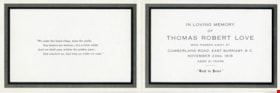
Memorial cards for Thomas Robert Love
https://search.heritageburnaby.ca/link/museumdescription10092
- Repository
- Burnaby Village Museum
- Date
- 1918
- Collection/Fonds
- Love family fonds
- Description Level
- File
- Physical Description
- 1 folder of textual records
- Scope and Content
- File consists of three memorial cards for Thomas Richard Love which read: "IN LOVING MEMORY / OF / THOMAS ROBERT LOVE / WHO PASSED AWAY AT / CUMBERLAND ROAD, EAST BURNABY, B.C. / NOVEMBER 23RD. 1918 / AGED 31 YEARS / Rest in Peace".A short, religious poem is printed on the inside face of the card. …
- Repository
- Burnaby Village Museum
- Collection/Fonds
- Love family fonds
- Description Level
- File
- Physical Description
- 1 folder of textual records
- Scope and Content
- File consists of three memorial cards for Thomas Richard Love which read: "IN LOVING MEMORY / OF / THOMAS ROBERT LOVE / WHO PASSED AWAY AT / CUMBERLAND ROAD, EAST BURNABY, B.C. / NOVEMBER 23RD. 1918 / AGED 31 YEARS / Rest in Peace".A short, religious poem is printed on the inside face of the card. "MADE IN ENGLAND" is printed very small in the lower right hand corner of the back of the card. Thomas Robert Love served in World War I and was a victim of the 1918 flu epidemic.
- History
- See extensive history of Love Family and Love farmhouse located at Burnaby Village Museum.
- Accession Code
- BV012.31.24
- Access Restriction
- No restrictions
- Reproduction Restriction
- No known restrictions
- Date
- 1918
- Media Type
- Textual Record
- Scan Resolution
- 600
- Scan Date
- 7-May-20
- Scale
- 100
- Notes
- Title based on content of file
Images
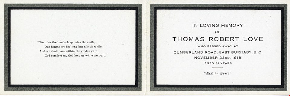
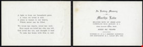
Memorial cards for Martha Love
https://search.heritageburnaby.ca/link/museumdescription10093
- Repository
- Burnaby Village Museum
- Date
- 1920
- Collection/Fonds
- Love family fonds
- Description Level
- File
- Physical Description
- 1 folder of textual records
- Scope and Content
- File consists of a three memorial cards for Martha Love which read: "In Loving Memory / OF / Martha Love / BELOVED WIFE OF JESSE LOVE / CUMBERLAND ROAD, BURNABY, B.C. / Died August 24RD. 1920 / AGED 62 YEARS / INTERRED IN I.O.O.F. CEMETERY, SAPPERTON / NEW WESTMINSTER, B.C., AUGUST 26TH, 1920". A s…
- Repository
- Burnaby Village Museum
- Collection/Fonds
- Love family fonds
- Description Level
- File
- Physical Description
- 1 folder of textual records
- Scope and Content
- File consists of a three memorial cards for Martha Love which read: "In Loving Memory / OF / Martha Love / BELOVED WIFE OF JESSE LOVE / CUMBERLAND ROAD, BURNABY, B.C. / Died August 24RD. 1920 / AGED 62 YEARS / INTERRED IN I.O.O.F. CEMETERY, SAPPERTON / NEW WESTMINSTER, B.C., AUGUST 26TH, 1920". A short, religious poem is printed on the inside face of the card. "IN LOVING / MEMORY" with an image of a rose is printed on the front face of the card.
- History
- See extensive history of Love Family and Love farmhouse located at Burnaby Village Museum.
- Accession Code
- BV012.31.25
- Access Restriction
- No restrictions
- Reproduction Restriction
- No known restrictions
- Date
- 1920
- Media Type
- Textual Record
- Scan Resolution
- 600
- Scan Date
- 7-May-20
- Scale
- 100
- Notes
- Title based on content of file
Images


Agricultural and floral societies' papers
https://search.heritageburnaby.ca/link/archivedescription57952
- Repository
- City of Burnaby Archives
- Date
- 1922 (date of original) -1970
- Collection/Fonds
- Burnaby Historical Society fonds
- Description Level
- File
- Physical Description
- 1 file of textual records and 1 photograph : b&w ; 8.5 cm x 8 cm
- Scope and Content
- File consists of miscellaneous promotional materials and certificates pertaining to agricultural and floral societies in British Columbia, including the Burnaby Rhododendron Society. File also contains one photograph a display at an agricultural fair.
- Repository
- City of Burnaby Archives
- Date
- 1922 (date of original) -1970
- Collection/Fonds
- Burnaby Historical Society fonds
- Subseries
- Bancroft family subseries
- Physical Description
- 1 file of textual records and 1 photograph : b&w ; 8.5 cm x 8 cm
- Description Level
- File
- Record No.
- MSS030-001
- Access Restriction
- No restrictions
- Reproduction Restriction
- May be restricted by third party rights
- Accession Number
- BHS1986-44
- Scope and Content
- File consists of miscellaneous promotional materials and certificates pertaining to agricultural and floral societies in British Columbia, including the Burnaby Rhododendron Society. File also contains one photograph a display at an agricultural fair.
- Media Type
- Textual Record
- Photograph
- Notes
- Title based on contents of file
Images

![Dedication of War Memorial Fountain at Burnaby Municipal Hall, [1923] thumbnail](/media/hpo/_Data/_BVM_Images/1985/1985_3137_0007_001.jpg?width=280)
Dedication of War Memorial Fountain at Burnaby Municipal Hall
https://search.heritageburnaby.ca/link/museumdescription237
- Repository
- Burnaby Village Museum
- Date
- [1923]
- Collection/Fonds
- Burnaby Village Museum Photograph collection
- Description Level
- File
- Physical Description
- 2 photographs : b&w prints
- Scope and Content
- Photographs of the War Memorial Fountain located on the lawn of Burnaby Municipal Hall, during its dedication ceremony. There is a large crowd of people gathered around the fountain, with boys in scout uniforms standing to the right of the fountain, and ladies and RCMP officers standing to the left…
- Repository
- Burnaby Village Museum
- Collection/Fonds
- Burnaby Village Museum Photograph collection
- Description Level
- File
- Physical Description
- 2 photographs : b&w prints
- Material Details
- inscribed in the original negative, and printed on the photograph, l.r. "Stride Photo"
- Scope and Content
- Photographs of the War Memorial Fountain located on the lawn of Burnaby Municipal Hall, during its dedication ceremony. There is a large crowd of people gathered around the fountain, with boys in scout uniforms standing to the right of the fountain, and ladies and RCMP officers standing to the left side of the fountain. There is a man standing next to the fountain, blowing on a trumpet. There is a wreath hanging from the top of the fountain, which bears the inscription, "OF OUR FELLOW WORKERS WHO FELL IN THE WAR/ 1914-1918/ ERECTED BY/ THE CIVIC EMPLOYEES UNION - BURNABY - 1923" The War Memorial Fountain is now located in the Burnaby Village Museum site.
- Subjects
- Ceremonies
- Monuments - War Memorials
- Wars - World War, 1914-1918
- Fountains
- Persons - Crowds
- Names
- Burnaby City Hall
- Geographic Access
- Kingsway
- Street Address
- 7282 Kingsway
- Accession Code
- BV985.3137.7
- Reproduction Restriction
- May be restricted by third party rights
- Date
- [1923]
- Media Type
- Photograph
- Historic Neighbourhood
- Edmonds (Historic Neighbourhood)
- Planning Study Area
- Stride Avenue Area
- Scan Resolution
- 600
- Scan Date
- 2024-02-02
- Photographer
- Stride, Charles Edgar
- Notes
- Title based on contents of photograph
- 1 b&w copy negative accompanying
Images
![Dedication of War Memorial Fountain at Burnaby Municipal Hall, [1923] thumbnail](/media/hpo/_Data/_BVM_Images/1985/1985_3137_0007_001.jpg)
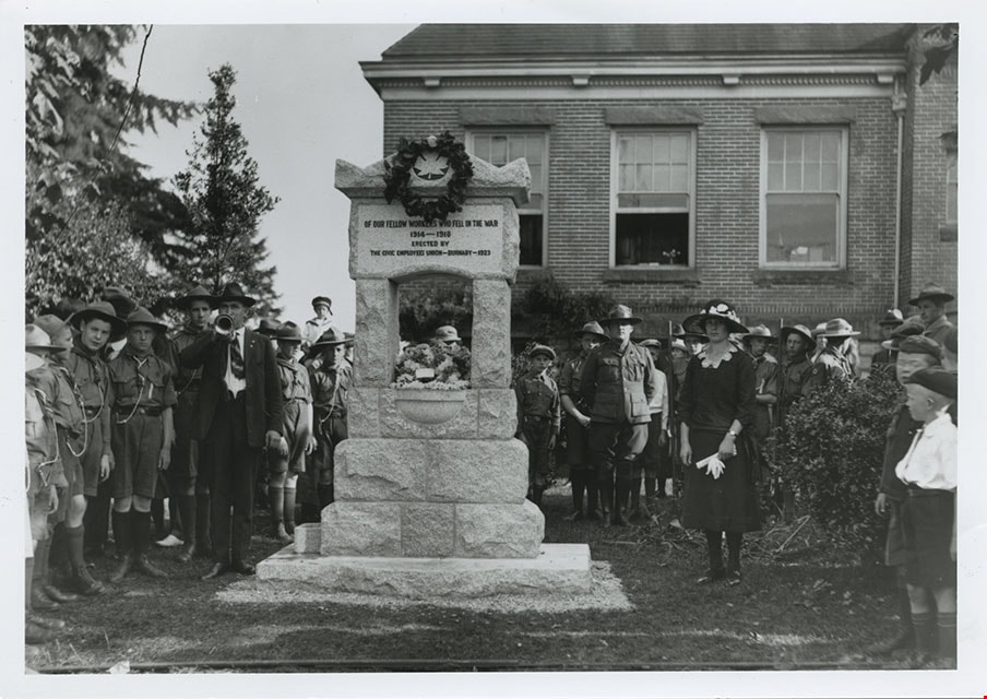
![50th Anniversary G.G.C., [1926-1979] thumbnail](/media/hpo/_Data/_BVM_Images/2015/2015_0035_0166_folded_redacted.jpg?width=280)
50th Anniversary G.G.C.
https://search.heritageburnaby.ca/link/museumdescription4594
- Repository
- Burnaby Village Museum
- Date
- [1926-1979]
- Collection/Fonds
- Burnaby Girl Guides fonds
- Description Level
- File
- Physical Description
- 1 scrapbook (51 photographs + 1 postcard + textual records)
- Scope and Content
- File consists of a scrapbook with a handpainted wood cover titled "50th Anniversary / G.G.C". The scrapbook documents events and ceremonies of the 4th Guide Company with the first half of the scrapbook containing photographs and documents regarding the 50th Anniversary of Girl Guides which was cele…
- Repository
- Burnaby Village Museum
- Collection/Fonds
- Burnaby Girl Guides fonds
- Description Level
- File
- Physical Description
- 1 scrapbook (51 photographs + 1 postcard + textual records)
- Scope and Content
- File consists of a scrapbook with a handpainted wood cover titled "50th Anniversary / G.G.C". The scrapbook documents events and ceremonies of the 4th Guide Company with the first half of the scrapbook containing photographs and documents regarding the 50th Anniversary of Girl Guides which was celebrated at St. Nicholas Church in 1960 while the second half documents earlier events from 1926, as well as other events in the 1960s such as; "Year of the Golden Jubilee", a parade in North Burnaby as well as Thinking Day 1976-1978, banquets, a disco contest, camping on Hollyburn mountain and a visit to Victoria in 1979. On November 3rd, 1926 the company was registered as the 5th Burnaby Guide company, in 1951 the number was changed to the 4th Vancouver Guide Company and in 1956 the number was changed to the 4th Burnaby Company.
- Accession Code
- BV015.35.166
- Access Restriction
- No restrictions
- Reproduction Restriction
- May be restricted by third party rights
- Date
- [1926-1979]
- Media Type
- Textual Record
- Photograph
- Notes
- Transcribed title
- Items within scrapbook have been redacted in compliance with Section 22 of FIPPA
- A selection of photographs are described at item level (BV015.35.285 to BV.015.35.300).
Images
![50th Anniversary G.G.C., [1926-1979] thumbnail](/media/hpo/_Data/_BVM_Images/2015/2015_0035_0166_folded_redacted.jpg)
Documents
![Interview with Shirley Cohn, [1926-2023] (interview content), interviewed 2023 thumbnail](/media/Hpo/_Data/_BVM_Sound_Recordings/Oral_Histories/2023_0016_0001_001.JPG?width=280)
Interview with Shirley Cohn
https://search.heritageburnaby.ca/link/museumdescription19597
- Repository
- Burnaby Village Museum
- Date
- [1926-2023] (interview content), interviewed 2023
- Collection/Fonds
- Burnaby Village Museum fonds
- Description Level
- File
- Physical Description
- 2 sound recordings (wav) (16 min., 57 sec.) (50 min., 36 sec.) + 1 sound recording (mp3) (50 min., 36 sec.)
- Scope and Content
- File consists of two recordings of oral history interviews with Shirley Cohn conducted by Burnaby Village Museum Registrar and Researcher, Eric Damer. The first interview was conducted on April 14, 2023 and the second interview was conducted on September 6, 2023. Summary of interview conducted on …
- Repository
- Burnaby Village Museum
- Collection/Fonds
- Burnaby Village Museum fonds
- Series
- Museum Oral Histories series
- Subseries
- Many Voices Project Interviews subseries
- Description Level
- File
- Physical Description
- 2 sound recordings (wav) (16 min., 57 sec.) (50 min., 36 sec.) + 1 sound recording (mp3) (50 min., 36 sec.)
- Material Details
- Interviewer: Eric Damer Interviewee: Shirley Cohn Location of Interviews: Burnaby Village Museum Interview Dates: April 14, 2023 and September 6, 2023 Total Number of Tracks: 2 Total Length of all Tracks: 67 min., 33 sec. Digital master recording (wav) recording of second interview (50 min., 36 sec.) was converted to mp3 for access on Heritage Burnaby
- Scope and Content
- File consists of two recordings of oral history interviews with Shirley Cohn conducted by Burnaby Village Museum Registrar and Researcher, Eric Damer. The first interview was conducted on April 14, 2023 and the second interview was conducted on September 6, 2023. Summary of interview conducted on September 6, 2023: 0:00 – 16:09 Shirley Cohn shares background information about her parents who immigrated to Detroit from Hungary in the 1930’s. Shirley recalls what it was like for her parents being Jewish during World War II and how many of their relations were killed in the Holocaust. Shirley talks about her Jewish Hungarian heritage, what it was like growing up in Detroit, the Jewish community in Detroit and the Jewish holidays and traditions that her family celebrated. Shirley recalls her high school and University education and experiences, starting her career in social work and how she met her future husband, Theodore “Ted” Cohn. 16:10 – 18:27 Shirley shares the story about her father in law, Dr. Daniel E. Cohn who was Harry Houdini’s doctor at the time of his death in Detroit on Oct. 31, 1926. Shirley explains that she donated some of Dr. Daniel E. Cohn’s original documents pertaining to this event to the New York Public Library. 18:28 – 26:04 Shirley describes her experiences living and working in London Ontario while her husband was a professor at University of Western Ontario and Shirley worked as a social worker in family services. Shirley recalls experiences of anti-Semitism while living in London. Shirley talks about moving to Burnaby in 1977 after her husband took a job as a professor at Simon Fraser University. Shirley describes her experiences living in Burnaby, raising a family and working as a social worker at Burnaby General Hospital. 26:05 – 26:18 Shirley talks about her interests outside of work, her family’s involvement in the Burquest Jewish Community Association and being a member of Temple Shalom. Shirley conveys information about other Jewish synagogues in Greater Vancouver, describes Reform Judaism at Temple Shalom and some Jewish cultural practices that her family has been involved with. 26:19 – 33:12 Shirley describes her family’s experiences living in the Garden Village nieghbourhood in Burnaby, her involvement sharing Jewish cultural traditions at her children’s school and recalls her children’s experiences attending school in Burnaby. 33:13 – 40:46 Shirley conveys the career paths that her children took and talks about what she likes about living in Burnaby including; the walking and hiking trails, the cultural and art performances and her involvement in local politics. Shirley talks about her and her husband’s involvement in the SFU retirees association and the SFURA walking and hiking group. Shirley reflects on her husband’s academic career, experiences teaching at SFU and the role of the Hillel Jewish Students Association at the Simon Fraser University. Shirley talks about the difficulties of discussing political views about the State of Israel. Shirley describes some traditional Jewish foods, the roles that they play and a local bakery that carries Jewish bake goods. 40:47 – 50:36 Shirley describes her current daily life in Burnaby; working one day a week as a social worker, gardening, her involvement at Temple Shalom and the Jewish Community Centre and how she travels in Burnaby. Shirley recalls the changes that she’s encountered in Burnaby and in her career over the years, shares a story about her husband losing his thesis and describes what Burnaby was like while she was raising her family. Shirley shares what she thinks about the areas of development in Burnaby and conveys the importance of having parks and affordable housing. In closing, Shirley reflects on what is like to be a Jewish person living in Burnaby.
- History
- Interviewee biography: Shirley Tanner was born in Detroit in 1947. Her parents were both Jewish. Her mother fled Hungary as a refugee in 1939, while her father emigrated from there in 1934. Shirley attended public schools in Detroit, and then studied social work at the University of Michigan. After marriage, Shirley and Ted Cohn moved to Ontario where Ted had a faculty appointment at the University of Western Ontario in political science. Six years later they moved to Burnaby for Ted’s teaching position in political science at Simon Fraser University. While living in Burnaby, Shirley took care of a growing family while also practicing social work, mainly at Burnaby Hospital. The family enjoyed Burnaby’s libraries and parks. Shirley helped out at her children’s schools, became a Block Watch captain, and the family joined Burquest Jewish Community Association. The Cohns later became members of Temple Sholom Synagogue in Vancouver, while remaining in Burnaby. Beginning in 2009, Ted started an informal hiking group for retired Simon Fraser University staff. This group has been open to others, so now has a wide variety of members. Shirley has also helped lead hikes in the region. Interviewer biography: Eric Damer is a Burnaby Village Museum Interpreter, Museum Registrar, Researcher and Blacksmith. Eric pounded hot steel for the first time in 1977 in junior high. Fifteen years later, he joined Burnaby Village Museum where he has smithed for three decades. He also provides historical research for museum exhibits and special projects. Outside the museum, Eric is a social historian with a special interest in educational history.
- Creator
- Burnaby Village Museum
- Subjects
- Education
- Recreational Activities - Hiking
- Organizations
- Organizations - Societies and Clubs
- Migration
- Persons - Jewish Canadians
- Religions - Judaism
- Social Issues - Racism
- Social Issues
- Wars - World War, 1939-1945
- Names
- Cohn, Dr. Daniel E.
- Cohn, Shirley
- Cohn, Theodore H. "Ted"
- Burquest
- Hillel Jewish Students Association
- Simon Fraser University
- SFURA walking and hiking group
- Simon Fraser University Retirees Association "SFURA"
- Temple Shalom
- Responsibility
- Damer, Eric
- Accession Code
- BV023.16.1
- Access Restriction
- No restrictions
- Reproduction Restriction
- No known restrictions
- Date
- [1926-2023] (interview content), interviewed 2023
- Media Type
- Sound Recording
- Notes
- Title based on contents of file
- Summary, recording and transcript of second interview available on Heritage Burnaby
Images
![Interview with Shirley Cohn, [1926-2023] (interview content), interviewed 2023 thumbnail](/media/Hpo/_Data/_BVM_Sound_Recordings/Oral_Histories/2023_0016_0001_001.JPG)
Documents
Audio Tracks
Interview with Shirley Cohn, [1926-2023] (interview content), interviewed 2023
Interview with Shirley Cohn, [1926-2023] (interview content), interviewed 2023
https://search.heritageburnaby.ca/media/hpo/_Data/_BVM_Sound_Recordings/Oral_Histories/2023_0016_0001_003.mp3