Narrow Results By
Subject
- Advertising Medium - Signs and Signboards 2
- Animals - Birds 9
- Arts - Drawings 1
- Arts - Paintings 11
- Building Components 1
- Buildings - Agricultural 4
- Buildings - Agricultural - Greenhouses 2
- Buildings - Agricultural - Stables 1
- Buildings - Civic 1
- Buildings - Civic - Community Centres 1
- Buildings - Civic - Museums 3
- Buildings - Commercial - Restaurants 1

James & Mary Herd Residence
https://search.heritageburnaby.ca/link/landmark604
- Repository
- Burnaby Heritage Planning
- Description
- Residential building.
- Associated Dates
- 1910
- Other Names
- STRATHMORE
- Street View URL
- Google Maps Street View
- Repository
- Burnaby Heritage Planning
- Other Names
- STRATHMORE
- Geographic Access
- Boundary Road North
- Associated Dates
- 1910
- Description
- Residential building.
- Heritage Value
- Designed for James Herd (1863-1940) and his wife, Mary Jane Barrie Herd (née Fenton, 1870-1956), this house was described “as a fine new home valued at… $7,000” by The British Columbian in 1912. Named after Mrs. Herd’s birthplace in the Strathmore Valley, Scotland, this was one of the first homes to be built in the Vancouver Heights subdivision. A full width verandah takes advantage of remarkable views of downtown Vancouver and Burrard Inlet. Though the architecture of the house has been altered by the addition of stucco cladding and the replacement of the original windows, it remains an excellent example of the Craftsman style, with the triangular eave brackets, granite clad verandah piers, square support columns and varied roofline with broad eaves that are characteristic of the style. It was the long-time residence of Joseph Wellington Kelly (1876-1962), a stationary engineer, and his wife Margaret Ann Kelly (née Allan, 1880-1968), who were married in Vancouver in 1901. Their son, Allan C. Kelly (died 2001) was an architect, who worked for the architectural firm Townley & Matheson from 1928 until the 1970s. Among many other projects undertaken for the firm, Allan Kelly was the project architect for Vancouver City Hall.
- Locality
- Vancouver Heights
- Historic Neighbourhood
- Vancouver Heights (Historic Neighbourhood)
- Planning Study Area
- Burnaby Heights Area
- Area
- 708.39
- Contributing Resource
- Building
- Ownership
- Private
- Street Address
- 510 Boundary Road North
- Street View URL
- Google Maps Street View
Images


J.A. Thurston House 'Altese'
https://search.heritageburnaby.ca/link/landmark511
- Repository
- Burnaby Heritage Planning
- Description
- The J.A. Thurston House is a very large, two and one-half storey plus basement wood-frame Arts and Crafts style house. It is located on the south side of Thurston Street, near Kingsway and the SkyTrain (formerly the interurban tramline route), within the Metrotown area of Burnaby and is now part of…
- Associated Dates
- 1912
- Formal Recognition
- Heritage Designation, Community Heritage Register
- Other Names
- John A. & Sarah Thurston House
- Street View URL
- Google Maps Street View
- Repository
- Burnaby Heritage Planning
- Other Names
- John A. & Sarah Thurston House
- Geographic Access
- Thurston Street
- Associated Dates
- 1912
- Formal Recognition
- Heritage Designation, Community Heritage Register
- Enactment Type
- Bylaw No. 9934
- Enactment Date
- 09/08/1993
- Description
- The J.A. Thurston House is a very large, two and one-half storey plus basement wood-frame Arts and Crafts style house. It is located on the south side of Thurston Street, near Kingsway and the SkyTrain (formerly the interurban tramline route), within the Metrotown area of Burnaby and is now part of a large apartment complex.
- Heritage Value
- The J.A. Thurston House demonstrates Burnaby's real estate and construction boom along the interurban tramline in 1911. The house was built for John Albert Thurston (1874-1944) and his wife Sarah Sedona Thurston (1879-1961). Typical of the entrepreneurial spirit of the age, John Thurston, a manager for the Leckie Shoe Company Limited in Vancouver, was also involved in real estate development, and purchased a twenty-one lot subdivision consisting of 3.2 hectares bound by the interurban tramline right-of-way to the south, Boundary Road to the west and Smith Street (now Thurston Street) to the north. Additionally, the J.A. Thurston House is an excellent, high quality example of an Arts and Crafts style dwelling, with numerous notable design elements such as the battered piers, the elaborate second storey dormer and stained glass windows with landscape and seascape motifs. The enormous scale of the house reflects a time when large families were common and domestic servants were needed to run the household. Indicative of the labour-saving devices and luxury features being introduced at the high end of the housing market, it was equipped with a built-in vacuum system, refrigeration, servant summoning devices and a round safe built into a fireplace mantle. The J.A. Thurston House also represents the proliferation during the Edwardian era of homes built from pattern books and standardized designs as a means to expedite the construction process and offer competitive costs.
- Defining Elements
- Key elements that define the heritage character of the J.A. Thurston House include its: - location on Thurston Street, in the old Central Park district - residential form, scale and massing as exemplified by its two and one-half storey plus above-ground basement height and regular, rectangular plan - Arts and Crafts style details such as the picturesque roofline, deep open eaves with exposed purlins, narrow lapped wooden siding on the first storey and cedar shingle siding on the upper storeys - broad and unusually steep side gabled roof, clad with cedar shingles - deeply-recessed full open front verandah with complementary recessed balcony in second storey dormer, incorporating both a gabled roof and shed roof - twinned and triple square bracketed columns on the verandahs and balcony - decorative battered verandah piers, supported on exposed beams - irregular fenestration, including: double-hung wooden-sash windows; picture windows; casement windows; and several stained glass windows with landscape and seascape motifs - tall brick external chimney on east facade - original interior features such as fireplaces, and wooden trim and floors
- Historic Neighbourhood
- Central Park (Historic Neighbourhood)
- Planning Study Area
- Garden Village Area
- Function
- Primary Historic--Single Dwelling
- Primary Current--Single Dwelling
- Community
- Burnaby
- Cadastral Identifier
- 018-224-113
- Boundaries
- The J.A. Thurston House is comprised of a single residential lot located at 3762 Thurston Street, Burnaby.
- Area
- 3880
- Contributing Resource
- Building
- Ownership
- Private
- Street Address
- 3762 Thurston Street
- Street View URL
- Google Maps Street View
Images


J.D. Shearer House
https://search.heritageburnaby.ca/link/landmark513
- Repository
- Burnaby Heritage Planning
- Description
- The J.D. Shearer House is a one and one-half storey British Arts and Crafts-style house distinguished by its picturesque roofline, half-timbered rough-cast stucco cladding on the upper floor and battered window casings. It is located on the south side of Buckingham Avenue at Haszard Street in Burna…
- Associated Dates
- 1912
- Formal Recognition
- Heritage Designation, Community Heritage Register
- Other Names
- John D. & Katherine Shearer House
- Street View URL
- Google Maps Street View
- Repository
- Burnaby Heritage Planning
- Other Names
- John D. & Katherine Shearer House
- Geographic Access
- Buckingham Avenue
- Associated Dates
- 1912
- Formal Recognition
- Heritage Designation, Community Heritage Register
- Enactment Type
- Bylaw No. 10423
- Enactment Date
- 26/08/1996
- Description
- The J.D. Shearer House is a one and one-half storey British Arts and Crafts-style house distinguished by its picturesque roofline, half-timbered rough-cast stucco cladding on the upper floor and battered window casings. It is located on the south side of Buckingham Avenue at Haszard Street in Burnaby's Deer Lake neighbourhood.
- Heritage Value
- Built in 1912, the J.D. Shearer House is an excellent example of the high quality residences constructed in the British Arts and Crafts style by affluent citizens in Burnaby's Deer Lake neighbourhood, promoted at the time as the equivalent of the prestigious Shaughnessy Heights development in Vancouver. The site of this house was part of Louis Claude Hill's Buckingham Estate subdivision. Development of these Edwardian era neighbourhoods in Burnaby was facilitated by the B.C. Electric Railway interurban line. In addition, the increasing availability of automobiles to the well-to-do families of the era sped up the process of urbanization in the outlying areas of Vancouver. Built for retired English military officer John D. Shearer and his wife, Katherine, the British Arts and Crafts design of the house represents associations with the Mother Country and the displays of patriotic loyalty considered desirable characteristics at the time. The picturesque charm and character of rural England is evoked in harmony with its woodland setting.
- Defining Elements
- Key elements that define the heritage character of the J.D. Shearer House include its: - location in the Buckingham Estate subdivision in the Deer Lake neighbourhood - residential form, scale and massing as exemplified by its one and one-half storey plus basement height, asymmetrical plan, front bay window and picturesque roofline - British Arts and Crafts details such as the half-timbering and rough-cast stucco on the upper storey, battered window casings, external clinker brick chimney on the east facade, deep overhanging closed eaves and bargeboards with distinctive lower returns - side gabled roof with gabled and shed dormers, clad in cedar - raised central entrance porch - irregular fenestration, including multi-paned transoms over casement windows - two internal red brick chimneys
- Historic Neighbourhood
- Burnaby Lake (Historic Neighbourhood)
- Planning Study Area
- Morley-Buckingham Area
- Function
- Primary Historic--Single Dwelling
- Primary Current--Single Dwelling
- Community
- Burnaby
- Cadastral Identifier
- 023-316-977
- Boundaries
- The J.D. Shearer House is comprised of a single residential lot located at 5573 Buckingham Avenue, Burnaby.
- Area
- 1044
- Contributing Resource
- Building
- Ownership
- Private
- Street Address
- 5573 Buckingham Avenue
- Street View URL
- Google Maps Street View
Images

Jerry Rogers' Ditch
https://search.heritageburnaby.ca/link/landmark738
- Repository
- Burnaby Heritage Planning
- Repository
- Burnaby Heritage Planning
- Heritage Value
- Jeremiah "Jerry" Rogers (b. 1818, St. Andrews, NB; d 24 Oct 1879, English Bay) began logging at a camp near Jericho Beach in 1865 (the name Jericho may be a corruption of “Jerry’s Cove.”) His operation, which cleared much of what is now Kitsilano, provided spars for sailing ships and logs for Edward Stamp's mill on Burrard Inlet. In the 1870s, he became one of the first logging operators in Burnaby, establishing a camp in South Burnaby in about 1870 at Woolard Creek (Byrne Creek), where he cut timber for ship masts. Rogers constructed a ditch to facilitate the movement of the large trees. It is likely a series of locks were installed in the ditch to trap the waters of the Fraser River when the tides were high, and to trap water flowing from Woolard Creek. When the locks were released, the logs could more easily make their way to the Fraser River. A similar system of locks was used west of Jerry Rogers' Ditch, at Byrne's logging ditch constructed by Peter Byrne in 1893.
- Historic Neighbourhood
- Fraser Arm (Historic Neighbourhood)
- Planning Study Area
- Big Bend Area

Jesse Love House
https://search.heritageburnaby.ca/link/landmark540
- Repository
- Burnaby Heritage Planning
- Description
- The Jesse Love House is a vernacular example of a late Victorian-era wood-frame farmhouse with later Arts and Crafts alterations and additions, that has been relocated to the Burnaby Village Museum. This two-storey house has an L-shaped plan, with a compound gabled roof, overhanging eaves and a lar…
- Associated Dates
- 1893
- Formal Recognition
- Heritage Designation, Community Heritage Register
- Other Names
- Jesse & Martha Love Farmhouse
- Street View URL
- Google Maps Street View
- Repository
- Burnaby Heritage Planning
- Other Names
- Jesse & Martha Love Farmhouse
- Geographic Access
- Deer Lake Avenue
- Associated Dates
- 1893
- Formal Recognition
- Heritage Designation, Community Heritage Register
- Enactment Type
- Bylaw No. 9807
- Enactment Date
- 23/11/1992
- Description
- The Jesse Love House is a vernacular example of a late Victorian-era wood-frame farmhouse with later Arts and Crafts alterations and additions, that has been relocated to the Burnaby Village Museum. This two-storey house has an L-shaped plan, with a compound gabled roof, overhanging eaves and a large wraparound verandah.
- Heritage Value
- The value of the Jesse Love House lies in its comprehensive representation of an early Burnaby farmhouse, and the typical additive growth of a home as the resident family prospered. Jesse Love (1849-1928) and his wife Martha Love (1858-1920) moved to Burnaby in 1893 with their family to start a fruit ranch and market garden on Cumberland Road in the East Burnaby district. Jesse Love was actively involved in community affairs, serving on the Burnaby School Board and also as a District Councillor in 1901 and from 1904-07. The original house was constructed by local builder George Salt and consisted of an entrance hall, dining room, lean-to kitchen, master bedroom and several rooms upstairs. As the family grew and prospered, additions were made to the house including a parlour, more bedrooms upstairs, and a large permanent kitchen. Jesse Love was actively involved in community affairs, and the kitchen became a local gathering spot for political discussion and civic organizations. The verandah, exterior shingle cladding, large windows, running water and electricity were eventually added as well. The heritage value for this house also lies in its interpretive value within the Burnaby Village Museum. The site is an important cultural feature for the interpretation of Burnaby’s heritage to the public. The house was moved to the Burnaby Village Museum in 1988 and both the interior and exterior were restored and interpreted to their 1925 period, including reproduction wallpaper.
- Defining Elements
- The character defining features of the Jesse Love House include its: - irregular form and massing - compound gable roof with cedar shingle cladding - Craftsman-style exterior features such as a shingled exterior and triangular eave brackets - multi-paned double-hung 2-over-2 wooden-sash windows; casement window assemblies with transoms in the Living Room - large wrap-around verandah - interior features such as pressed tin ceilings, original wallpapers and cedar panelled kitchen - reproduction Arts and Crafts parlour document wallpaper and border
- Locality
- Deer Lake Park
- Historic Neighbourhood
- Burnaby Lake (Historic Neighbourhood)
- Planning Study Area
- Morley-Buckingham Area
- Organization
- Burnaby Village Museum
- Builder
- George Salt
- Function
- Primary Current--Museum
- Primary Historic--Single Dwelling
- Community
- Burnaby
- Cadastral Identifier
- P.I.D. No. 011-030-356 Legal Description: Parcel 1, District Lot 79 and District Lot 85, Group 1, New Westminster District, Reference Plan 77594
- Boundaries
- Burnaby Village Museum is comprised of a single municipally-owned property located at 6501 Deer Lake Avenue, Burnaby.
- Area
- 38,488.63
- Contributing Resource
- Building
- Landscape Feature
- Structure
- Ownership
- Public (local)
- Documentation
- Heritage Site Files: PC77000 20. City of Burnaby Planning and Building Department, 4949 Canada Way, Burnaby, B.C., V5G 1M2
- Street Address
- 6501 Deer Lake Avenue
- Street View URL
- Google Maps Street View
Images


John & Hattie Standish Residence
https://search.heritageburnaby.ca/link/landmark607
- Repository
- Burnaby Heritage Planning
- Description
- Residential building.
- Associated Dates
- c.1912
- Street View URL
- Google Maps Street View
- Repository
- Burnaby Heritage Planning
- Geographic Access
- Edmonds Street
- Associated Dates
- c.1912
- Description
- Residential building.
- Heritage Value
- This square, two-storey house displays vertical proportions, with a pyramidal roof and central dormer. It features narrow double-hung windows, lapped siding on the first storey, and shingle siding on the second divided by a belt course, and has retained a high degree of original integrity. It was built for John Albert Standish (1862-1913), a farmer who left this home to his wife, Hattie and their children after his death.
- Locality
- Edmonds
- Historic Neighbourhood
- Edmonds (Historic Neighbourhood)
- Planning Study Area
- Edmonds Area
- Area
- 367.94
- Contributing Resource
- Building
- Ownership
- Private
- Street Address
- 7408 Edmonds Street
- Street View URL
- Google Maps Street View
Images


John Houston Residence
https://search.heritageburnaby.ca/link/landmark610
- Repository
- Burnaby Heritage Planning
- Description
- Residential building.
- Associated Dates
- c.1908
- Street View URL
- Google Maps Street View
- Repository
- Burnaby Heritage Planning
- Geographic Access
- Burris Street
- Associated Dates
- c.1908
- Description
- Residential building.
- Heritage Value
- The original resident of this house was John Houston, listed in the 1909 City Directory as a ‘rancher’, but is known as the long-time home of barrister Wrathman Sheridan Turner (1889-1974) and his wife Gertrude Helena (née Whealhouse) Turner. Stucco now covers the original exterior siding, though the house maintains its wide, overhanging eaves with exposed rafter tails and triangular eave brackets, indicative of the influence of the newly-emerging Arts and Crafts style.
- Locality
- Burnaby Lake
- Historic Neighbourhood
- Burnaby Lake (Historic Neighbourhood)
- Planning Study Area
- Morley-Buckingham Area
- Area
- 1312.47
- Contributing Resource
- Building
- Ownership
- Private
- Street Address
- 7668 Burris Street
- Street View URL
- Google Maps Street View
Images


John & Jessie MacLean Residence
https://search.heritageburnaby.ca/link/landmark608
- Repository
- Burnaby Heritage Planning
- Description
- Residential building.
- Associated Dates
- c.1926
- Street View URL
- Google Maps Street View
- Repository
- Burnaby Heritage Planning
- Geographic Access
- Pandora Street
- Associated Dates
- c.1926
- Description
- Residential building.
- Heritage Value
- This cottage illustrates the traditionalism of the interwar years, when domestic ideals were expressed through modest homes displaying period revival influences. Reflecting the influence of the British Arts and Crafts movement, it features a symmetrical plan, a side jerkin-headed roof, a gabled front dormer and twin-coursed shingle siding, and retains its original wooden-sash windows with unusual multi-paned upper sash. It was built for John R. and Jessie MacLean. The house was recently restored by the owners.
- Locality
- Vancouver Heights
- Historic Neighbourhood
- Vancouver Heights (Historic Neighbourhood)
- Planning Study Area
- Burnaby Heights Area
- Area
- 566.71
- Contributing Resource
- Building
- Ownership
- Private
- Street Address
- 3827 Pandora Street
- Street View URL
- Google Maps Street View
Images


John & Roseanna Clark House
https://search.heritageburnaby.ca/link/landmark567
- Repository
- Burnaby Heritage Planning
- Description
- Residential building.
- Associated Dates
- 1912
- Formal Recognition
- Heritage Designation, Community Heritage Register
- Street View URL
- Google Maps Street View
- Repository
- Burnaby Heritage Planning
- Geographic Access
- Dundas Street
- Associated Dates
- 1912
- Formal Recognition
- Heritage Designation, Community Heritage Register
- Enactment Type
- Bylaw No. 12640
- Enactment Date
- 22/06/2009
- Description
- Residential building.
- Heritage Value
- While simple in form, this sophisticated Edwardian-era house is finely detailed and maintains a high degree of its original integrity. The symmetrical home’s most distinct characteristic is its full width inset verandah with octagonal columns supporting second floor projection. This was the home of John William Clark (1886-1947), an English-born carpenter who retired in 1926, and his wife Roseanna Clark (1860-1933).
- Locality
- Vancouver Heights
- Historic Neighbourhood
- Vancouver Heights (Historic Neighbourhood)
- Planning Study Area
- Burnaby Heights Area
- Community
- Burnaby
- Contributing Resource
- Building
- Ownership
- Private
- Street Address
- 4115 Dundas Street
- Street View URL
- Google Maps Street View
Images


Johnson & Berg House
https://search.heritageburnaby.ca/link/landmark611
- Repository
- Burnaby Heritage Planning
- Description
- Residential building.
- Associated Dates
- 1913
- Street View URL
- Google Maps Street View
- Repository
- Burnaby Heritage Planning
- Geographic Access
- Eton Street
- Associated Dates
- 1913
- Description
- Residential building.
- Heritage Value
- This Edwardian-era bungalow displays an impressive mix of details added to a modest suburban form. A hipped roof was rarely used in conjunction with the Craftsman style. Here, the tapered verandah piers, attic balcony columns and gable screen reference the Craftsman style, while the overall symmetrical form and roofline are more typical Edwardian features. It appears to have been built as a revenue property by business partners and local builders, Herman Johnson and Ole Berg in 1913 and rented by them as late as 1939.
- Locality
- Vancouver Heights
- Historic Neighbourhood
- Vancouver Heights (Historic Neighbourhood)
- Planning Study Area
- Burnaby Heights Area
- Area
- 374.03
- Contributing Resource
- Building
- Ownership
- Private
- Street Address
- 4247 Eton Street
- Street View URL
- Google Maps Street View
Images


Johnson & Mary Skinner Residence
https://search.heritageburnaby.ca/link/landmark551
- Repository
- Burnaby Heritage Planning
- Description
- Residential building.
- Associated Dates
- c.1912
- Other Names
- Timms House
- Street View URL
- Google Maps Street View
- Repository
- Burnaby Heritage Planning
- Other Names
- Timms House
- Geographic Access
- Marine Drive
- Associated Dates
- c.1912
- Description
- Residential building.
- Heritage Value
- This house was originally built by Fraser Arm pioneer and postmaster Johnson Alfred Skinner (1864-1941) and his wife, Mary Emma Skinner (née Bailey, 1862-1929). Johnson, who was from Sussex, worked as a horticulturalist. This is an unusual variation on the Craftsman style, with a side gabled roof and a half-width front verandah. Local mason John Pickard completed the distinctive battered cobblestone masonry, including the foundation, chimney, verandah columns and the porte-cochère. The house was later occupied and remodeled by the Timms family.
- Locality
- Fraser Arm
- Historic Neighbourhood
- Fraser Arm (Historic Neighbourhood)
- Planning Study Area
- Big Bend Area
- Ownership
- Private
- Street Address
- 5634 Marine Drive
- Street View URL
- Google Maps Street View
Images


Joseph & Anne Gartlan Residence
https://search.heritageburnaby.ca/link/landmark612
- Repository
- Burnaby Heritage Planning
- Description
- Residential building.
- Associated Dates
- c.1913
- Street View URL
- Google Maps Street View
- Repository
- Burnaby Heritage Planning
- Geographic Access
- Oxford Street
- Associated Dates
- c.1913
- Description
- Residential building.
- Heritage Value
- This house was owned by Joseph Paul Gartlan (1877-1967), a steam shovel engineer for the B.C. Electric Company from 1906 to 1943, and his wife, Annie Claudia Gartlan (née Wood, 1891-1933). Joseph was a long-time resident of the house, remaining until his death in 1967. Typical of the Edwardian era, this bungalow has a side gabled roof with a large front gable over the balcony, an open front verandah with square tapered columns, and a mix of narrow lapped wooden siding, square shingles and diamond shingles in the gable peak.
- Locality
- Vancouver Heights
- Historic Neighbourhood
- Vancouver Heights (Historic Neighbourhood)
- Planning Study Area
- Burnaby Heights Area
- Area
- 374.03
- Contributing Resource
- Building
- Ownership
- Private
- Street Address
- 4111 Oxford Street
- Street View URL
- Google Maps Street View
Images


Joseph Clarke House
https://search.heritageburnaby.ca/link/landmark505
- Repository
- Burnaby Heritage Planning
- Description
- The Joseph Clarke House is a two and one-half storey, wood-frame house, with shingle siding, a front-gabled roof and a full open front verandah. It is located on Jersey Avenue within the Central Park neighbourhood of Burnaby.
- Associated Dates
- 1909
- Formal Recognition
- Heritage Designation, Community Heritage Register
- Other Names
- Joseph & Ellen Clarke House, Clarke Residence
- Street View URL
- Google Maps Street View
- Repository
- Burnaby Heritage Planning
- Other Names
- Joseph & Ellen Clarke House, Clarke Residence
- Geographic Access
- Jersey Avenue
- Sandell Street
- Associated Dates
- 1909
- Formal Recognition
- Heritage Designation, Community Heritage Register
- Enactment Type
- By-law No. 11930
- Enactment Date
- 29/08/2005
- Description
- The Joseph Clarke House is a two and one-half storey, wood-frame house, with shingle siding, a front-gabled roof and a full open front verandah. It is located on Jersey Avenue within the Central Park neighbourhood of Burnaby.
- Heritage Value
- Built circa 1909 for Central Park farmer Joseph Clarke (1851-1936) and his wife, Ellen (1864-1938), this Edwardian-era farm house is valued for its vernacular design, which demonstrates the utilitarian nature of working-class housing during the boom years prior to the First World War. The Joseph Clarke House is additionally valued for its link with the development of the Central Park neighbourhood during the Edwardian era. The advent of the Central Park interurban rail line in 1892, operated by the B.C. Electric Company, connected the area to Vancouver and led to its suburban development. This is one of the oldest surviving houses in the Central Park neighbourhood. It was designated as a municipal heritage site in 2005 and rehabilitated as part of the adjacent multi-family townhouse and apartment redevelopment.
- Defining Elements
- Key elements that define the heritage character of the Joseph Clarke House include its: - location on Jersey Avenue in the Central Park neighbourhood - residential form, scale and massing as expressed by its two and one-half storey height with rectangular plan, front bay window and front-gabled roof - wood-frame construction - Edwardian era detailing such as the open front verandah, asymmetrical front entrance, glazed front door with sidelights and triangular eave brackets
- Historic Neighbourhood
- Central Park (Historic Neighbourhood)
- Planning Study Area
- Garden Village Area
- Function
- Primary Historic--Single Dwelling
- Primary Current--Single Dwelling
- Community
- Burnaby
- Cadastral Identifier
- P.I.D. 027-101-428
- Boundaries
- The Joseph Clarke House is comprised of a single residential lot located at 5575 Jersey Avenue, Burnaby.
- Area
- 2370
- Contributing Resource
- Building
- Ownership
- Private
- Documentation
- City of Burnaby Planning and Building Department, Heritage Site Files
- Names
- Clarke, Joseph
- Clarke, Ellen
- Street Address
- 5575 Jersey Avenue
- Street View URL
- Google Maps Street View
Images


Joseph & Jane Wintemute House
https://search.heritageburnaby.ca/link/landmark523
- Repository
- Burnaby Heritage Planning
- Description
- The Wintemute House is a large two-storey wood-frame Victorian era country farm house with Victorian Italianate detailing. Designed in a symmetrical Foursquare form, it features a low-pitched hipped roof with deep eaves. Later additions to the rear of the house, and the extensive wraparound veranda…
- Associated Dates
- 1891
- Formal Recognition
- Heritage Designation, Community Heritage Register
- Other Names
- Burnett House
- Street View URL
- Google Maps Street View
- Repository
- Burnaby Heritage Planning
- Other Names
- Burnett House
- Geographic Access
- Berkley Street
- Associated Dates
- 1891
- Formal Recognition
- Heritage Designation, Community Heritage Register
- Enactment Type
- Bylaw No. 6889
- Enactment Date
- 07/03/1977
- Description
- The Wintemute House is a large two-storey wood-frame Victorian era country farm house with Victorian Italianate detailing. Designed in a symmetrical Foursquare form, it features a low-pitched hipped roof with deep eaves. Later additions to the rear of the house, and the extensive wraparound verandah and porte-cochere, were Edwardian era additions. It is located on its original site, in the modern subdivision of Buckingham Heights in southeast Burnaby. The Burnett House is one of the oldest surviving houses in Burnaby.
- Heritage Value
- Built circa 1891, the Joseph and Jane Wintemute House is valued as a representation of the early history of Burnaby and its agricultural origins. Built prior to the civic incorporation of Burnaby in 1892, the house was situated to face Douglas Road (now Canada Way), one of the first roads built to connect the rural farmlands of Burnaby to New Westminster. The original large property has been extensively subdivided and the house is now isolated in a modern subdivision. Designated in 1977, the Wintemute House is also significant as Burnaby's first protected municipal heritage site. The house is valued for its association with Joseph S. Wintemute (1832-1911) and Jane Wintemute (1832-1910), who came to British Columbia from Port Stanley, Ontario in 1865, traveling via the Isthmus of Panama. Joseph Wintemute, a skilled carpenter and contractor by trade, operated the Wintemute Furniture Factory in New Westminster, the first furniture plant established on the mainland of British Columbia. In 1891, he acquired this property, where he set up a cord wood sawmill to supply his factory. Wintemute was likely responsible for the design and construction of this commodious structure, as it was built in an Eastern Canadian style he would have been familiar with. After the lands were cleared of timber, the Wintemutes developed the property into a typical small-scale 'market garden,’ involved in the production of vegetables and fruits, such as strawberries, for sale at the New Westminster City Market. The Wintemute House is additionally significant for its association with the speculative land boom that occurred prior to the First World War, and ongoing suburban subdivision. Charles Gordon, a real estate agent, acquired the Wintemute farm and subdivided the acreage, which he marketed through the People’s Trust Company as 'Montrelynview' and offered this house as a draw prize to lot purchasers. With the collapse of the land boom, the house remained in Gordon’s possession until 1929 when it was purchased by his brother-in-law, Geoffrey Burnett, a local surveyor responsible for many of the original land surveys of Burnaby. David Burnett, Geoffrey's son, requested designation of the house when the family decided to subdivide the remaining 1.4 hectares of property in 1977. Furthermore, the Wintemute House is valued as an excellent example of a Victorian era country farm house, based loosely on the traditional farmhouses seen commonly in nineteenth century Ontario. Designed in a vernacular version of the Victorian Italianate style, the house displays restrained detailing, including several original multi-paned windows notable for their vertical proportions. The house retains many original exterior features, and the original interior layout, although modernized during the Edwardian era, is substantially intact, including finely crafted maple and cedar interior millwork that was produced by the Wintemute Furniture Factory. From 1904 to 1910, Charles Gordon, the second owner, made a number of alterations to the house including the addition of the wrap-around verandah, a porte-cochere and a 7.6 metre by 9 metre billiard room in the Arts and Crafts style, beamed and panelled in Douglas Fir. These later additions and alterations have value in demonstrating the evolution of the house and property and changing tastes at the turn of the nineteenth century.
- Defining Elements
- Key elements that define the heritage character of the Wintemute House include its: - picturesque original setting with views to the North Shore - residential form, scale and massing as expressed by its symmetrical cubic form and two-storey height, with later additions to the rear - Victorian Italianate architectural features such as the vertically-proportioned original windows with vestigial window hoods, low-pitched hipped roof and Classical Revival details such as the corner boards articulated as pilasters - hipped roof with deep boxed eaves - horizontal lapped narrow wooden siding - second storey balcony over front entry - wide wraparound columned verandah with porte-cochere, with square trimmed columns - irregular fenestration: original Victorian era double-hung 6-over-6 wood-sash windows with vertical proportions and segmental arched tops; Edwardian era double-hung 1-over-1 wooden-sash windows; and Edwardian era wooden-sash casement window assemblies with leaded transoms - central front entry with sidelights and transom - multi-paned French doors opening out to verandah - interior features such as its 3.7 metre ceiling height on the main and second floors; the coal grate fireplace with elaborate woodwork and glazed tile surround in the front parlour; five other fireplaces throughout the house; maple and cedar interior millwork; and the Douglas Fir panelled and beamed billiard room with hidden doors, seven-panelled doors, original light fixtures and mouldings - internal red brick chimneys with corbelled caps
- Historic Neighbourhood
- Burnaby Lake (Historic Neighbourhood)
- Planning Study Area
- Morley-Buckingham Area
- Function
- Primary Historic--Single Dwelling
- Primary Current--Single Dwelling
- Community
- Burnaby
- Cadastral Identifier
- 003-297-152
- Boundaries
- The Wintemute House is comprised of a single residential lot located at 7640 Berkley Street, Burnaby.
- Area
- 1566.73
- Contributing Resource
- Building
- Ownership
- Private
- Names
- Wintemute, Joseph
- Street Address
- 7640 Berkley Street
- Street View URL
- Google Maps Street View
Images


J.R. & Frances Dawson Residence
https://search.heritageburnaby.ca/link/landmark599
- Repository
- Burnaby Heritage Planning
- Description
- Residential building.
- Associated Dates
- c.1912
- Street View URL
- Google Maps Street View
- Repository
- Burnaby Heritage Planning
- Geographic Access
- Cambridge Street
- Associated Dates
- c.1912
- Description
- Residential building.
- Heritage Value
- This beautifully-detailed house displays a highly sophisticated mix of fashionable Arts and Crafts elements. The asymmetrical design has stacked inset verandahs on one side, with the ground floor verandah wrapping around the side of the house. The second floor verandah has an arched opening, supported by short versions of the ground floor columns and accessed by French doors with geometric patterned, multi-paned glazing. A semi-circular lunette window lights the attic, and banked windows with leaded transoms are used on the front façade. Decorative details include triangular eave brackets and square verandah columns with distinctive bracketted capitals. The house has survived in original condition except for a later asbestos siding that was applied over the original shingle siding, and the enclosure of the side verandah. The home was owned by J.R. Dawson and Frances Abigail Dawson (née Thompson, 1853-1938) from 1915 until Frances’ death in 1938.
- Locality
- Vancouver Heights
- Historic Neighbourhood
- Vancouver Heights (Historic Neighbourhood)
- Planning Study Area
- Burnaby Heights Area
- Area
- 566.71
- Contributing Resource
- Building
- Ownership
- Private
- Street Address
- 3746 Cambridge Street
- Street View URL
- Google Maps Street View
Images


J.S. & Mina Reid Residence
https://search.heritageburnaby.ca/link/landmark600
- Repository
- Burnaby Heritage Planning
- Description
- Residential building.
- Associated Dates
- c.1913
- Street View URL
- Google Maps Street View
- Repository
- Burnaby Heritage Planning
- Geographic Access
- Frances Street
- Associated Dates
- c.1913
- Description
- Residential building.
- Heritage Value
- The gable-on-hipped roofline is this house’s most unique feature. The home is a typical plan of the Foursquare type with the addition of an inset second-storey verandah. The full open front verandah has square columns and closed balustrades. A coloured glass transom was used above the living room window assembly. By 1915, the house was owned by J.S. and Mina Reid (1874-1969).
- Locality
- Vancouver Heights
- Historic Neighbourhood
- Vancouver Heights (Historic Neighbourhood)
- Planning Study Area
- Burnaby Heights Area
- Area
- 377.10
- Contributing Resource
- Building
- Ownership
- Private
- Street Address
- 3851 Frances Street
- Street View URL
- Google Maps Street View
Images


Jubilee Grove Arch
https://search.heritageburnaby.ca/link/landmark533
- Repository
- Burnaby Heritage Planning
- Description
- The Jubilee Grove Arch sits at the corner of Kingsway and Patterson Avenue. Located within Central Park, the ceremonial arch and its decorative plantings provide a visual anchor to the northeast corner and entry point to the park.
- Associated Dates
- 1939
- Formal Recognition
- Heritage Designation, Community Heritage Register
- Street View URL
- Google Maps Street View
- Repository
- Burnaby Heritage Planning
- Geographic Access
- Imperial Street
- Associated Dates
- 1939
- Formal Recognition
- Heritage Designation, Community Heritage Register
- Enactment Type
- Bylaw No. 9807
- Enactment Date
- 23/11/1992
- Description
- The Jubilee Grove Arch sits at the corner of Kingsway and Patterson Avenue. Located within Central Park, the ceremonial arch and its decorative plantings provide a visual anchor to the northeast corner and entry point to the park.
- Heritage Value
- Jubilee Grove Arch was dedicated as part of the municipality’s celebration of the Jubilee of the coronation of King George V and was dedicated during Burnaby’s annual May Day celebrations in 1935. Much of the construction work was carried out by local citizens under the direction of the Burnaby Engineering Department through a Depression era work relief program that provided a way for local residents to pay their taxes. The garden was also chosen as the site for the ceremonial planting of an oak tree from the Royal Forest at Windsor, in honor of the Coronation of King George VI and Queen Elizabeth in 1937. The original bronze garden dedication plaque and oak tree remain at the site today. The decorative stone arch was erected in 1939 as a symbol of Burnaby's, and the Lower Mainland of British Columbia’s, strong ties to the English monarchy at the time, and the arch’s unveiling during May Day ceremonies shows the social role that such a commemorative feature played both to the local government and people of Burnaby. It was erected just prior to the Royal Visit of 1939, the first time that reigning British monarchs had travelled to Canada. Built of Haddington Island sandstone, the arch itself was reconstructed from a salvaged architectural element of a historic Vancouver landmark. The arch originally framed the entrance door to the Vancouver Club building in Vancouver, built in 1893-94 on West Hastings Street and designed by architect C.O. Wickenden. The building was demolished in 1930, however the arch was stored and rebuilt as the focal point of the Jubilee Grove after being bought by the Municipality of Burnaby. The work was undertaken by Italian-born stone mason Rizieri Stefanini (1879-1954), the owner of Burnaby Monumental Works. The re-use of the arch symbolizes the close tie between Vancouver and Burnaby and the joint evolution of the neighbouring cities.
- Defining Elements
- The Jubilee Grove Arch has character-defining elements that recognize it both as a remnant of a past building and as a new and individual structure. These include its: - axial diagonal placement and prominent corner location marking one of the entries to Central Park - visibility and accessibility as a public monument - hand carved stone blocks of Haddington Island sandstone - decorative twisted-rope motif carved to outline the arch - supporting rusticated sidewalls with planting urns - original bronze dedication plaque - flanking ornamental gardens - Royal Oak tree and plaque
- Historic Neighbourhood
- Central Park (Historic Neighbourhood)
- Planning Study Area
- Maywood Area
- Organization
- City of Burnaby
- Architect
- C.O. Wickenden
- Function
- Primary Current--Park Fixture
- Primary Historic--Park Fixture
- Community
- Burnaby
- Cadastral Identifier
- P.I.D. No. 017-767-172 Legal Description: Block B of Lot 2 Except Firstly: Part on Plan 8669 and Secondly: Part on Plan LMP4689 District Lot 151, Group 1, New Westminster District, Plan 3443
- Boundaries
- The property (Central Park) is a municipally-owned park that lies at the western edge of Burnaby, between 49th Avenue to the south, Kingsway to the north, Boundary Road to the west and Patterson Avenue to the east.
- Area
- 853,403.82
- Contributing Resource
- Structure
- Landscape Feature
- Ownership
- Public (local)
- Documentation
- Heritage Site Files: PC77000 20. City of Burnaby Planning and Building Department, 4949 Canada Way, Burnaby, B.C., V5G 1M2
- Names
- Burnaby Monumental Works
- Street Address
- 3883 Imperial Street
- Street View URL
- Google Maps Street View
Images


Kapoor Mill
https://search.heritageburnaby.ca/link/landmark683
- Repository
- Burnaby Heritage Planning
- Associated Dates
- 1939
- Heritage Value
- In 1939, Mr. Kapoor Singh Siddoo purchased the eastern section of the former Barnet Mill site from the City of Burnaby and founded Kapoor Sawmills Ltd. The mill was struck by disaster in 1947 when a fire caused $500,000.00 in damage to the property. A smaller mill was rebuilt and was in operation until 1959. Mr. Siddoo, who had been considered to be one of the most influential men in Vancouver's East Indian Community, died in 1964. The mill site became inactive except for a sand and gravel storage area that was used by the Kask Brothers Company, and in 1972 the family sold the property to the Municipality of Burnaby who later turned it into the Barnet Marine Park.
- Historic Neighbourhood
- Barnet (Historic Neighbourhood)
- Planning Study Area
- Burnaby Mountain Area
Images


Kask Brothers
https://search.heritageburnaby.ca/link/landmark684
- Repository
- Burnaby Heritage Planning
- Geographic Access
- Barnet Road
- Associated Dates
- 1925
- Heritage Value
- In 1925, William Kask Sr. and his family purchased land along the Barnet Road and built what became known as Kask's Camp, where cabins were rented out to families working at the Barnet Mill. The family - William Kask Jr., Dave and Jack - went on to expand their business into a lumber and concrete supply company and in 1936, the company was named the Kask Brothers Building Supply Company. A lumber office was established on Curtis Street and the concrete plant was built at the former site of the cabin camp. To a large degree, the camp catered to Immigrants from Nordic countries who were active in the lumber trade. Many Finns felt at home in the camp, as the Kasks spoke Finnish and there were steam baths available.
- Historic Neighbourhood
- Lochdale (Historic Neighbourhood)
- Planning Study Area
- Westridge Area
- Street Address
- 7501 Barnet Road
Images


Kelly-Douglas Company
https://search.heritageburnaby.ca/link/landmark697
- Repository
- Burnaby Heritage Planning
- Geographic Access
- Kingsway
- Associated Dates
- 1946
- Heritage Value
- The Kelly Douglas Company was founded in 1896 as a wholesale grocery business. It enjoyed rapid success during the Klondike Goldrush of 1898 when it became a primary supplier for prospectors. In 1946, its headquarters moved from Vancouver to Burnaby and a manufacturing plant and warehouse was built on the site.
- Historic Neighbourhood
- Central Park (Historic Neighbourhood)
- Planning Study Area
- Maywood Area
- Street Address
- 4700 Kingsway
Images


Kensington Arena
https://search.heritageburnaby.ca/link/landmark787
- Repository
- Burnaby Heritage Planning
- Geographic Access
- Curtis Street
- Associated Dates
- 1973
- Heritage Value
- In 1972, the Burnaby Parks Commission considered numerous requests from the community to increase the available ice rink surfaces in the city and voted to build a new full-sized rink instead of adding to the existing municipal rink facility. The new arena was to be situated in North Burnaby and was opened in 1973 adjacent to Kensington Park.
- Planning Study Area
- Parkcrest-Aubrey Area
- Street Address
- 6159 Curtis Street
- Street View URL
- Google Maps Street View
Images


Kingsway
https://search.heritageburnaby.ca/link/landmark775
- Repository
- Burnaby Heritage Planning
- Associated Dates
- 1913
- Heritage Value
- The years 1911-1912 saw great expansion and settlement in Burnaby and large public works projects were undertaken to service the growing community. One project that was determined to be a necessity was the construction of a proper highway between New Westminster and Vancouver. The Province and the Municipality agreed to share the costs of construction (with Burnaby paying 25% and the Province 75%) and so Kingsway was built to improve the current Vancouver Road. The road was named after the famous King's Way in London, England.
- Historic Neighbourhood
- Central Park (Historic Neighbourhood)
- Edmonds (Historic Neighbourhood)
- Planning Study Area
- Maywood Area
- Marlborough Area
- Windsor Area
- Kingsway-Beresford Area
- Stride Avenue Area
- Edmonds Area
Images


Kingsway-Beresford Neighbourhood
https://search.heritageburnaby.ca/link/landmark805
- Repository
- Burnaby Heritage Planning
- Associated Dates
- 1955-2008
- Heritage Value
- Since the building boom of the 1950s, the Kingsway-Beresford Neighbourhood has maintained a residential character with the exception of the Kingsway corridor, which has become a primary commercial and light industrial sector.
- Historic Neighbourhood
- Edmonds (Historic Neighbourhood)
- Planning Study Area
- Kingsway-Beresford Area
Images


Kingsway East School
https://search.heritageburnaby.ca/link/landmark546
- Repository
- Burnaby Heritage Planning
- Description
- The Kingsway East School is a two-storey wood-frame Arts and Crafts styled building. The school, and the adjacent cenotaph and memorial tennis courts, comprise Burnaby South Memorial Park.
- Associated Dates
- 1913
- Formal Recognition
- Heritage Designation, Community Heritage Register
- Other Names
- Alan Emmott Centre
- Street View URL
- Google Maps Street View
- Repository
- Burnaby Heritage Planning
- Other Names
- Alan Emmott Centre
- Geographic Access
- Southoaks Crescent
- Associated Dates
- 1913
- Formal Recognition
- Heritage Designation, Community Heritage Register
- Enactment Type
- Bylaw No. 9807
- Enactment Date
- 23/11/1992
- Description
- The Kingsway East School is a two-storey wood-frame Arts and Crafts styled building. The school, and the adjacent cenotaph and memorial tennis courts, comprise Burnaby South Memorial Park.
- Heritage Value
- This school structure completed in 1913, the oldest surviving public education building in the city, was intended to be the auditorium and gymnasium for Burnaby’s first high school. However, because of the 1913 recession and the outbreak of the First World War, it was utilized as the Kingsway East Elementary School for the Edmonds District until 1921. Burnaby South High School opened here in 1922, and after it relocated this building was used for a variety of school purposes until it became redundant. The school was rehabilitated for community purposes in 2002-03 and renamed the Alan Emmott Centre to honor a former Mayor of Burnaby. The impressive scale of the Kingsway East School is indicative of the relative size of the community and its growing demand for schooling at the time of construction, illustrating the value that early community residents placed on education. Built to plans of the Burnaby School Board architect, Joseph Henry Bowman (1864-1943), it also indicates the individual values and design control exercised by the school board during this era. It is also significant for its Arts and Crafts style, allied to the typical Craftsman residential vocabulary, which was employed locally for school buildings of the Edwardian era. By using a common architectural vocabulary, this allowed the institution to reflect the values and aspirations of the local community. The Arts and Crafts style also demonstrated an allegiance to British educational antecedents and a demonstration of loyalty to the Mother Country.
- Historic Neighbourhood
- Edmonds (Historic Neighbourhood)
- Planning Study Area
- Kingsway-Beresford Area
- Function
- Primary Historic--Primary School
- Community
- Burnaby
- Cadastral Identifier
- P.I.D. No. 016-367-154 Legal Description: Lot 1, District Lot 96, Group 1 New Westminster District, Plan 86581
- Boundaries
- The Kingsway East School is comprised of a single municipally-owned property located at 6650 Southoaks Crescent, Burnaby.
- Area
- 6,070.00
- Contributing Resource
- Building
- Landscape Feature
- Structure
- Ownership
- Public (local)
- Documentation
- Heritage Site Files: PC77000 20. City of Burnaby Planning and Building Department, 4949 Canada Way, Burnaby, B.C., V5G 1M2
- Street Address
- 6650 Southoaks Crescent
- Street View URL
- Google Maps Street View
Images


Kitchener Elementary School
https://search.heritageburnaby.ca/link/landmark614
- Repository
- Burnaby Heritage Planning
- Description
- School building.
- Associated Dates
- 1925
- Street View URL
- Google Maps Street View
- Repository
- Burnaby Heritage Planning
- Geographic Access
- Gilmore Avenue
- Associated Dates
- 1925
- Description
- School building.
- Heritage Value
- This landmark school was designed by the architectural firm of Bowman & Cullerne, specialists in the design of educational facilities. After Harold Cullerne (1890-1976) returned from service during the First World War, he joined J.H. Bowman (1864-1943) in a partnership that lasted from 1919 to 1934. The firm’s projects include the Seaforth School (1922, now relocated to Burnaby Village Museum), Burnaby North High School (1923), and the Nelson Avenue School (1927). This was originally designed as a two-storey, four-room building in 1925, with two-storey four-room wings added two years later. The building has been altered with the addition of stucco cladding over the original siding and replacement windows, but has retained its original form and massing, as well as its domed roof ventilator.
- Locality
- Vancouver Heights
- Historic Neighbourhood
- Vancouver Heights (Historic Neighbourhood)
- Planning Study Area
- Willingdon Heights Area
- Architect
- Bowman & Cullerne
- Area
- 20478.11
- Contributing Resource
- Building
- Street Address
- 1351 Gilmore Avenue
- Street View URL
- Google Maps Street View
Images

Kitty Hill
https://search.heritageburnaby.ca/link/archivedescription66567
- Repository
- City of Burnaby Archives
- Date
- 1904
- Collection/Fonds
- Peers Family and Hill Family fonds
- Description Level
- Item
- Physical Description
- 1 photograph : b&w + 1 watercolour painting
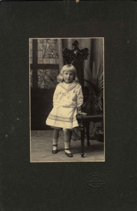
- Scope and Content
- Photograph is a portrait of Kitty Hill, posing next to a high-back chair. Accompanying the photograph is a watercolour painting that was based on this photograph, done on a linen backing.
- Repository
- City of Burnaby Archives
- Date
- 1904
- Collection/Fonds
- Peers Family and Hill Family fonds
- Physical Description
- 1 photograph : b&w + 1 watercolour painting
- Description Level
- Item
- Record No.
- 477-1181
- Access Restriction
- No restrictions
- Reproduction Restriction
- No known restrictions
- Accession Number
- 2007-12
- Scope and Content
- Photograph is a portrait of Kitty Hill, posing next to a high-back chair. Accompanying the photograph is a watercolour painting that was based on this photograph, done on a linen backing.
- Media Type
- Photograph
- Graphic Material
- Notes
- Title based on contents of photograph
Images

Kushiro Cup Selection Committee subseries
https://search.heritageburnaby.ca/link/archivedescription96463
- Repository
- City of Burnaby Archives
- Date
- 1997-2012
- Collection/Fonds
- City Council and Office of the City Clerk fonds
- Description Level
- Subseries
- Physical Description
- 13 folders of textual records + 2 photographs + 2 floppy discs
- Scope and Content
- Subseries consists of committee records for the Kushiro Cup Selection Committee including agendas, minutes, and committee reports.
- Repository
- City of Burnaby Archives
- Date
- 1997-2012
- Collection/Fonds
- City Council and Office of the City Clerk fonds
- Series
- Council Committee series
- Physical Description
- 13 folders of textual records + 2 photographs + 2 floppy discs
- Description Level
- Subseries
- Scope and Content
- Subseries consists of committee records for the Kushiro Cup Selection Committee including agendas, minutes, and committee reports.
- History
- This committee has been annually struck in order to choose an outstanding Burnaby citizen as the Kushiro Cup Award Citizen of the Year.
- Media Type
- Textual Record
- Photograph
- Graphic Material

Lake City Neighbourhood
https://search.heritageburnaby.ca/link/landmark702
- Repository
- Burnaby Heritage Planning
- Associated Dates
- 1925-1954
- Heritage Value
- When the Lake City Industrial Park first opened in the 1950's, it was a fairly isolated industrial enclave with convenient access to rail and road transportation routes. The sense of entrepreneurial flare and success that was anticipated for the area is evident in the naming of local streets which include "Production", "Enterprise" and "Venture". The anticipated potential of the area was also demonstrated by the inclusion of many significant development amenities of the time, such as paved streets, site landscaping, rail service, natural gas service, and architectural controls.
- Planning Study Area
- Lake City Area
Images


Lake City Neighbourhood
https://search.heritageburnaby.ca/link/landmark793
- Repository
- Burnaby Heritage Planning
- Associated Dates
- 1955-2008
- Heritage Value
- When Simon Fraser University opened in 1965, approximately sixteen industrial properties had been developed in the Lake City Industrial Park. In addition, significant tracts of land in the western portion had been pre-cleared and graded in anticipation of additional development, while most of the eastern half remained forested. Some of the early companies to locate in the area were Nabob Foods, Volkswagen Canada, British Columbia Television Broadcasting, Simpson Sears, and H.Y. Louie Company Limited. Both Imperial Oil and Shell Oil established petroleum storage and distribution facilities in the area. Initially a heavy industrial area, by 1979, single family neighbourhoods south of Lougheed Highway and west of Eagle Creek had been largely developed. By the mid1980's, the Burnaby 200 multi-family development along Forest Grove Drive had also been completed.
- Planning Study Area
- Lake City Area
Images


Lakeview Elementary School
https://search.heritageburnaby.ca/link/landmark834
- Repository
- Burnaby Heritage Planning
- Geographic Access
- Mayfield Street
- Associated Dates
- 1958
- Heritage Value
- The Burnaby School Inspector's report of 1955 estimated that by 1960, the total enrolment in Burnaby would go up by over 8000 pupils. As a result, new schools needed to be built to manage this increase, Lakeview being only one of many. Lakeview opened in 1958 with 193 students. Additions to the school were made in 1965 and 1969.
- Historic Neighbourhood
- Burnaby Lake (Historic Neighbourhood)
- Planning Study Area
- Lakeview-Mayfield Area
- Street Address
- 7777 Mayfield Street
- Street View URL
- Google Maps Street View
Images


Lakeview-Mayfield Neighbourhood
https://search.heritageburnaby.ca/link/landmark830
- Repository
- Burnaby Heritage Planning
- Associated Dates
- 1955-2008
- Heritage Value
- Like many other areas of the City, the Lakeview-Mayfield Neighbourhood was subdivided during the 1950s post-war building boom. Pockets of newer homes were built in the 1970s, and the neighbourhood retained its character as a primarily residential area. The neighbourhood is bordered to the east by Robert Burnaby Park.
- Planning Study Area
- Lakeview-Mayfield Area
Images


Lewis & Millicent Physick Residence
https://search.heritageburnaby.ca/link/landmark616
- Repository
- Burnaby Heritage Planning
- Description
- Residential building.
- Associated Dates
- 1939
- Street View URL
- Google Maps Street View
- Repository
- Burnaby Heritage Planning
- Geographic Access
- Boundary Road North
- Associated Dates
- 1939
- Description
- Residential building.
- Heritage Value
- This modest residence was built for Lewis Baker Physick (1905-1971), a freight dispatcher for B.C. Motor Transport Company who later worked for B.C. Hydro, and Millicent Physick (née Edwards, 1894-1971), a hairdresser, who lived here until their respective deaths. Situated on a terraced lot with stone-clad retaining walls, this home was influenced by the British Arts and Crafts style, which remained popular throughout the 1930s. Such stylistic influence can be seen in the second floor overhang, which is supported by false beams, leaded casement windows and steeply pitched roof and front gable. The roofline is enhanced by a jerkin-headed roof on the front gable. Apart from the addition of a later south elevation extension, the house remains in excellent original condition. Located on an elevated site, this residence has an unobstructed view of downtown Vancouver and Burrard Inlet.
- Locality
- Vancouver Heights
- Historic Neighbourhood
- Vancouver Heights (Historic Neighbourhood)
- Planning Study Area
- Burnaby Heights Area
- Area
- 566.71
- Contributing Resource
- Building
- Ownership
- Private
- Street Address
- 420 Boundary Road North
- Street View URL
- Google Maps Street View
Images


Lochdale Community Hall
https://search.heritageburnaby.ca/link/landmark549
- Repository
- Burnaby Heritage Planning
- Description
- The Lochdale Community Hall is a one-storey wood-frame building located on Sperling Avenue, near its intersection with Hastings Street, in the centre of the Lochdale district in North Burnaby. Built in stages, its current configuration has an L-shaped plan, with three different roof structures.
- Associated Dates
- 1925
- Formal Recognition
- Heritage Designation, Community Heritage Register
- Street View URL
- Google Maps Street View
- Repository
- Burnaby Heritage Planning
- Geographic Access
- Sperling Avenue
- Associated Dates
- 1925
- Formal Recognition
- Heritage Designation, Community Heritage Register
- Enactment Type
- Bylaw No. 9807
- Enactment Date
- 23/11/1992
- Description
- The Lochdale Community Hall is a one-storey wood-frame building located on Sperling Avenue, near its intersection with Hastings Street, in the centre of the Lochdale district in North Burnaby. Built in stages, its current configuration has an L-shaped plan, with three different roof structures.
- Heritage Value
- The heritage value of the Lochdale Community Hall is as Burnaby’s last remaining early community hall building. It was constructed with volunteer labour and donated materials in 1925 through the efforts of the Lochdale Social Club. The Hall is a valuable reminder of the way in which early communities banded together for mutual support at a time when transportation was more difficult and local communities were more isolated than today. This residents’ association has used this building to support the community through public political meetings, theatre, dinners and dances, creating strong community ties in North Burnaby. The Hall was also used briefly for the services of St. Margaret of Scotland Anglican parish until their church was completed in 1929, demonstrating a spirit of community cooperation at a time when local institutions were being established in the area.
- Defining Elements
- Key elements that define the heritage character of the Lochdale Community Hall include its: - central location in the Lochdale community - modest vernacular architecture and massing - stepped-pitch gable roof of the main hall - shallow-pitched gable roof of the entrance porch - Craftsman style eave brackets - central front entry - interior features such as the main open hall with an elevated stage
- Locality
- Lochdale
- Historic Neighbourhood
- Lochdale (Historic Neighbourhood)
- Planning Study Area
- Lochdale Area
- Organization
- Lochdale Social Club
- Function
- Primary Current--Recreation Centre
- Primary Historic--Recreation Centre
- Community
- Burnaby
- Cadastral Identifier
- P.I.D. No. 012-091-901 Legal Description: Lot 11 Except: East five feet , Block 6, District Lot 206, Group 1, New Westminster District, Plan 1323
- Boundaries
- The Lochdale Community Hall is comprised of a single municipally-owned property located at 490 Sperling Avenue, Burnaby.
- Area
- 1,260.00
- Contributing Resource
- Building
- Ownership
- Public (local)
- Other Collection
- St. Margaret of Scotland Parish Fonds, Anglican Diocese of New Westminster Archives.
- Documentation
- Heritage Site Files: PC77000 20. City of Burnaby Planning and Building Department, 4949 Canada Way, Burnaby, B.C., V5G 1M2
- Street Address
- 490 Sperling Avenue
- Street View URL
- Google Maps Street View
Images


Lochdale Neighbourhood
https://search.heritageburnaby.ca/link/landmark668
- Repository
- Burnaby Heritage Planning
- Associated Dates
- 1925-1954
- Heritage Value
- In the 1931 "Burnaby Year Book" the Lochdale neighbourhood is described as follows: "Lochdale…is situated at the intersection of the Hastings-Barnet road at the point where Sperling Avenue crosses…Situated at the intersection…there are an up to date service station and a general store, at which the Lochdale Post Office is situated. Immediately north of this is the seventy acres on which the Shell Oil Co. are to build an up-to-date refinery...On going south on Sperling Avenue can be found some lovely homes of the residents, all of which possess the most beautiful flower gardens, some of which are hobbies, and some being in the nature of a business. Others are engaged in chicken farming...while others find employment at the Barnet Mill about two miles east on the Hastings-Barnet Road."
- Historic Neighbourhood
- Lochdale (Historic Neighbourhood)
- Planning Study Area
- Lochdale Area
Images


Lochdale Neighbourhood
https://search.heritageburnaby.ca/link/landmark743
- Repository
- Burnaby Heritage Planning
- Associated Dates
- 1905-1924
- Heritage Value
- "Picturesquely situated on the south-westerly slope of the highest hill on the Burrard Peninsula is a district that in many ways resembles the early pioneer settlements…its centre is at the intersection of east Hastings Street and Sperling Avenue. Only a few years ago a dense forest covered this area and the settlers were few and some distance apart. After the war working men began to enter the Lochdale woods in quest of cheap home-sites. Today there are more than 400 residents in the district who combine to make a happy contented industrious community living on the edge of a big city yet enjoying the life offered by the country...The Community Hall is the centre of all social activities. Dances, concerts and other forms of entertainment are all there...Curtis Street runs from Sperling Avenue up to the hill, locally known as Hastings Grove. From the top on a clear day there is a view for miles around." ~ From the Sunday Province, March 8, 1925.
- Historic Neighbourhood
- Lochdale (Historic Neighbourhood)
- Planning Study Area
- Lochdale Area
Images


Lochdale Neighbourhood
https://search.heritageburnaby.ca/link/landmark790
- Repository
- Burnaby Heritage Planning
- Associated Dates
- 1955-2008
- Heritage Value
- Despite the rapid growth witnessed in Burnaby in the post-war years, the Lochdale Neighbourhood was characterised as a close-knit primarily residential community. Although a commercial zone developed along Sperling and Hastings, single-family, duplex and multi-family homes were the primary buildings in the area. Basement suites and student accommodation also flourished in this neighbourhood after the creation of Simon Fraser University on Burnaby Mountain.
- Historic Neighbourhood
- Lochdale (Historic Neighbourhood)
- Planning Study Area
- Lochdale Area
Images


Lochdale School
https://search.heritageburnaby.ca/link/landmark677
- Repository
- Burnaby Heritage Planning
- Geographic Access
- Aubrey Street
- Associated Dates
- 1953
- Heritage Value
- Lochdale Community School was opened in 1953 to help alleviate the increased enrolment at Sperling Elementary School caused by the new subdivisions under construction in this section of Burnaby. Lochdale was typical of the schools built at the period with classrooms constructed in a line, as close as possible to ground level. As needed, new classrooms were extended in a line and there were additions to Lochdale in 1962, 1964, 1966, 1971 and 1976.
- Historic Neighbourhood
- Lochdale (Historic Neighbourhood)
- Planning Study Area
- Lochdale Area
- Street Address
- 6990 Aubrey Street
- Street View URL
- Google Maps Street View
Images


Lonsdale Guardhouse Residence
https://search.heritageburnaby.ca/link/landmark617
- Repository
- Burnaby Heritage Planning
- Description
- Residential building.
- Associated Dates
- 1914
- Street View URL
- Google Maps Street View
- Repository
- Burnaby Heritage Planning
- Geographic Access
- Canada Way
- Associated Dates
- 1914
- Description
- Residential building.
- Heritage Value
- The house was built by Lonsdale L. Guardhouse, who was employed with the real estate company of Merithew & Ramsay in 1912. The British Columbian reported in November 1913 that: "Mr. L.L. Guardhouse, a well-known New Westminster man has recently let the contract for a home on Douglas Road near Edmonds Street. This Building is to be erected after the bungalow style and will cost when completed about $4,000." This Craftsman style pattern-book residence is notable for its unusual roofline, which features gently curved eaves. The house remains in excellent original condition and retains its lapped and shingled siding. Other notable features of the house include its pre-cast concrete block foundation–simulated to look like cut stone–and a rustic red-brick chimney. The front verandah has been altered through the removal of its floor structure. Many houses at the time were built from Craftsman-style pattern book designs, which were readily available in magazines and brochures. This house has a twin located in New Westminster at 315 Fifth Avenue.
- Locality
- Edmonds
- Historic Neighbourhood
- Edmonds (Historic Neighbourhood)
- Planning Study Area
- Richmond Park Area
- Area
- 828.85
- Contributing Resource
- Building
- Ownership
- Private
- Street Address
- 6985 Canada Way
- Street View URL
- Google Maps Street View
Images


Louis & Annie Hill Residence
https://search.heritageburnaby.ca/link/landmark504
- Repository
- Burnaby Heritage Planning
- Description
- The Louis and Annie Hill Residence is a modest one-storey, wood-frame, side-gabled Arts and Crafts bungalow with two projecting front gables, that was originally part of the Deer Lake Crescent Subdivision. The lot is heavily treed, and sits near the east end of Deer Lake.
- Associated Dates
- 1925
- Street View URL
- Google Maps Street View
- Repository
- Burnaby Heritage Planning
- Geographic Access
- Deer Lake Avenue
- Associated Dates
- 1925
- Description
- The Louis and Annie Hill Residence is a modest one-storey, wood-frame, side-gabled Arts and Crafts bungalow with two projecting front gables, that was originally part of the Deer Lake Crescent Subdivision. The lot is heavily treed, and sits near the east end of Deer Lake.
- Heritage Value
- The heritage value of the Louis and Annie Hill Residence lies in its association with prominent Burnaby pioneers, Louis Hill (1860-1931) and his wife, Annie Sara Hill (née Kenrick, 1864-1957). Originally from London, England, Louis Hill immigrated to Burnaby circa 1887, and established a small fruit farm on this site in 1891. Hill was elected to the first municipal council in 1892, when Burnaby was incorporated, and was later responsible for the subdivision of Buckingham Estate in the Deer Lake neighbourhood. The Louis and Annie Hill Residence, built as a retirement home in 1925, is further valued as a representation of the continued suburban development of the Deer Lake Crescent Subdivision, that was originally promoted in 1911 as an upper class suburban neighbourhood. Its modest nature illustrates the reduced scale of residential construction during the austere times that followed the end of the First World War. The style of the house demonstrates the late persistence of the Arts and Crafts movement, which remained a strong influence on domestic architecture. In 2006, the Louis and Annie Hill Residence was purchased by the City of Burnaby, and today it is part of the Deer Lake Park Heritage Precinct, Burnaby's most significant collection of historic sites.
- Defining Elements
- Key elements that define the heritage character of the Louis and Annie Hill Residence include its: - location within the Deer Lake Park Heritage Precinct - residential form, scale and massing as expressed by its one-storey height plus crawlspace, side-gabled-roof, front projecting gables, square projecting front bay and open front porch - wood-frame construction with original wood siding intact under a later coat of stucco - modest Arts and Crafts details such as diamond-point triangular eave brackets - windows, including double-hung, 1-over-1 wooden sash windows with horns - associated landscape features, including mature cedars lining the driveway
- Historic Neighbourhood
- Burnaby Lake (Historic Neighbourhood)
- Planning Study Area
- Morley-Buckingham Area
- Function
- Primary Historic--Single Dwelling
- Primary Current--Single Dwelling
- Community
- Deer Lake
- Cadastral Identifier
- P.I.D.012-446-963
- Boundaries
- The Louis and Annie Hill Residence is comprised of a single residential lot located at 6570 Deer Lake Avenue, Burnaby.
- Area
- 1521.75
- Contributing Resource
- Building
- Ownership
- Public (local)
- Documentation
- City of Burnaby Planning and Building Department, Heritage Site Files
- Street Address
- 6570 Deer Lake Avenue
- Street View URL
- Google Maps Street View
Images


Louis Claude Hill home "Brookfield"
https://search.heritageburnaby.ca/link/landmark725
- Repository
- Burnaby Heritage Planning
- Geographic Access
- Deer Lake Avenue
- Associated Dates
- 1894
- Heritage Value
- In 1894, Burnaby pioneer L. Claude Hill built this home near the shore of Deer Lake. Mr. Hill was married that year to Annie Sara Kenrick, and they took up residence in the house until 1906 when they sold the property and built a new home in the vicinity of Buckingham and Sperling. Brookfield was still on the property when the Burnaby Village Museum was planned in 1971 as Heritage Village, but it was removed to make room for other buildings on the site. In 1894, Claude discovered a midden on his farm and recovered many artifacts. In 2002, his descendants donated this valuable collection to the Museum.
- Historic Neighbourhood
- Burnaby Lake (Historic Neighbourhood)
- Planning Study Area
- Morley-Buckingham Area
- Street Address
- 6501 Deer Lake Avenue
Images


Lozells Neighbourhood
https://search.heritageburnaby.ca/link/landmark701
- Repository
- Burnaby Heritage Planning
- Associated Dates
- 1925-1954
- Heritage Value
- Like a lot of residential neighbourhoods in Burnaby during the post-War boom, the Lozells area during the 1925-1954 period was one of new construction and subdivisions. Although more homes were being built, the neighbourhood still retained a somewhat rural characteristic well into the 1950s.
- Historic Neighbourhood
- Lozells (Historic Neighbourhood)
- Planning Study Area
- Government Road Area
Images


Lozells Neighbourhood
https://search.heritageburnaby.ca/link/landmark756
- Repository
- Burnaby Heritage Planning
- Associated Dates
- 1905-1924
- Heritage Value
- In 1906 C.T. Piper and Alfred Wiggs built a sawmill at the foot of what is now Piper Avenue along the north shore of Burnaby Lake. These operations and the proximity of the Great Northern Railway encourage settlers to move into this area and among them were Colonel and Mrs. James Ward. They were authorized to open a post office here and Mrs. Ward named it 'Lozells' after the Anglican parish to which she had been a member in Birmingham, England.
- Historic Neighbourhood
- Lozells (Historic Neighbourhood)
- Planning Study Area
- Government Road Area
Images


Lucy Turner Residence
https://search.heritageburnaby.ca/link/landmark618
- Repository
- Burnaby Heritage Planning
- Description
- Residential building.
- Associated Dates
- 1930
- Street View URL
- Google Maps Street View
- Repository
- Burnaby Heritage Planning
- Geographic Access
- Boundary Road North
- Associated Dates
- 1930
- Description
- Residential building.
- Heritage Value
- This house was built for Lucy Lillian Turner (1881-1959), the daughter of Captain Andrew Jackson Cates of North Vancouver. Lucy Turner was the widow of Robert Ketchson Turner (1871-1918), who was a purser for her father’s Terminal Steam Navigation Company. They were married in 1913; Robert died during the 1918 Spanish Influenza epidemic and was buried at Mountain View Cemetery in Vancouver. Located on an elevated site, this residence boasts an unobstructed view of downtown Vancouver and Burrard Inlet and is situated amidst a context of homes of a similar age and scale. Demonstrating the late influence of the Craftsman style, this one and one-half storey house has triangular eave brackets and exposed rafter tails and purlins. A central wall dormer projects over the central front entry. Though the integrity of the house has been compromised with a later coat of stucco over the original siding, it maintains its double-hung wooden windows and original form, scale and massing.
- Locality
- Vancouver Heights
- Historic Neighbourhood
- Vancouver Heights (Historic Neighbourhood)
- Planning Study Area
- Burnaby Heights Area
- Area
- 566.71
- Contributing Resource
- Building
- Ownership
- Private
- Street Address
- 324 Boundary Road North
- Street View URL
- Google Maps Street View
Images


Lyndhurst Elementary School
https://search.heritageburnaby.ca/link/landmark706
- Repository
- Burnaby Heritage Planning
- Geographic Access
- Lyndhurst Street
- Associated Dates
- 1953
- Heritage Value
- The Lyndhurst Elementary School was built in 1953 to replace the previous school - the Hamilton Road School - which had served the community since 1910.
- Historic Neighbourhood
- Burquitlam (Historic Neighbourhood)
- Planning Study Area
- Lyndhurst Area
- Street Address
- 9847 Lyndhurst Street
- Street View URL
- Google Maps Street View
Images


Lyndhurst Neighbourhood
https://search.heritageburnaby.ca/link/landmark823
- Repository
- Burnaby Heritage Planning
- Associated Dates
- 1955-2008
- Heritage Value
- The Lyndhurst Neighbourhood falls within the Lougheed Town Centre area - one of four Town Centres in Burnaby. The Lyndhurst Neighbourhood accounts for a significant portion of the residential component of the Town Centre. To the east of Stoney Creek Park, lies the Sullivan Heights single family subdivision which was built in the 1950s. To the west of the park, is a higher-density residential area consisting of multi-family buildings that were developed after 1974.
- Historic Neighbourhood
- Burquitlam (Historic Neighbourhood)
- Planning Study Area
- Lyndhurst Area
Images

![Macgillivray's warbler, [1955] thumbnail](/media/hpo/_Data/_Archives_Images/_Unrestricted/559/559-006.jpg?width=280)
Macgillivray's warbler
https://search.heritageburnaby.ca/link/archivedescription82751
- Repository
- City of Burnaby Archives
- Date
- [1955]
- Collection/Fonds
- Hazel Simnett collection
- Description Level
- Item
- Physical Description
- 1 painting : colour print ; 37 x 28 cm
- Scope and Content
- Painting shows two Macgillvray's warblers.
- Repository
- City of Burnaby Archives
- Date
- [1955]
- Collection/Fonds
- Hazel Simnett collection
- Physical Description
- 1 painting : colour print ; 37 x 28 cm
- Description Level
- Item
- Record No.
- 559-006
- Access Restriction
- In Archives only
- Reproduction Restriction
- No reproduction permitted
- Accession Number
- 2013-22
- Scope and Content
- Painting shows two Macgillvray's warblers.
- Subjects
- Animals - Birds
- Arts - Paintings
- Media Type
- Graphic Material
- Creator
- Lansdowne, James Fenwick
- Notes
- Title transcribed from item
- Simnett personal papers series
Images
![Macgillivray's warbler, [1955] thumbnail](/media/hpo/_Data/_Archives_Images/_Unrestricted/559/559-006.jpg)

Marlborough Elementary School
https://search.heritageburnaby.ca/link/landmark695
- Repository
- Burnaby Heritage Planning
- Geographic Access
- Marlborough Avenue
- Associated Dates
- 1950
- Heritage Value
- Marlborough Elementary School was built in 1950 and was the second elementary school to be built in Burnaby after the start of the World War Two housing boom. Its design helped establish the general plans for future schools built in the city during this period - no basements, second stories or high stairways. Classrooms could easily be added, in line, as the need arose. There were additions made to Marlborough in 1952, 1961, 1967 and 1971.
- Historic Neighbourhood
- Central Park (Historic Neighbourhood)
- Planning Study Area
- Marlborough Area
- Street Address
- 6060 Marlborough Avenue
- Street View URL
- Google Maps Street View
Images


Marlborough Neighbourhood
https://search.heritageburnaby.ca/link/landmark802
- Repository
- Burnaby Heritage Planning
- Associated Dates
- 1955-2008
- Heritage Value
- The Marlborough Neighbourhood is another residential area that was witness to rapid growth and subdivision during the 1950s and 1960s, creating primarily single-family housing stock. In the 1970s and 1980s, as the commercial district around Kingsway grew, so too did higher density housing projects such as townhomes and condominiums.
- Historic Neighbourhood
- Central Park (Historic Neighbourhood)
- Planning Study Area
- Marlborough Area
Images


Mary McNeil Residence
https://search.heritageburnaby.ca/link/landmark620
- Repository
- Burnaby Heritage Planning
- Description
- Residential building.
- Associated Dates
- 1930
- Street View URL
- Google Maps Street View
- Repository
- Burnaby Heritage Planning
- Geographic Access
- MacDonald Avenue North
- Associated Dates
- 1930
- Description
- Residential building.
- Heritage Value
- Built for Mary McNeil, this house is a well-preserved example of an interwar Period Revival cottage, combining eclectic elements such as curved entrance porch buttresses, rolled roof edges, round-arched windows, smooth stucco cladding and imitation voussoirs. The house retains its original window sash with leaded glass panes.
- Locality
- Vancouver Heights
- Historic Neighbourhood
- Vancouver Heights (Historic Neighbourhood)
- Planning Study Area
- Burnaby Heights Area
- Area
- 566.71
- Contributing Resource
- Building
- Ownership
- Private
- Street Address
- 310 Macdonald Avenue North
- Street View URL
- Google Maps Street View
Images


Mary Sutcliffe Residence
https://search.heritageburnaby.ca/link/landmark621
- Repository
- Burnaby Heritage Planning
- Description
- Residential building.
- Associated Dates
- c.1930
- Street View URL
- Google Maps Street View
- Repository
- Burnaby Heritage Planning
- Geographic Access
- Boundary Road North
- Associated Dates
- c.1930
- Description
- Residential building.
- Heritage Value
- Built at a time when historical styles were favoured for domestic construction, this charming cottage residence was built for Mary Seymour Sutcliffe (1870-1959), the wife of retired painter Arthur Sutcliffe (1863-1932). It was inspired by the British Arts and Crafts movement, as displayed in the half-timbering, rounded door hood and the picturesque, jerkin-headed roof with exposed purlins. While this house has a Boundary Road address, the house faces north instead of west, facing an elevated and extraordinary view of Burrard Inlet.
- Locality
- Vancouver Heights
- Historic Neighbourhood
- Vancouver Heights (Historic Neighbourhood)
- Planning Study Area
- Burnaby Heights Area
- Area
- 566.71
- Contributing Resource
- Building
- Ownership
- Private
- Street Address
- 650 Boundary Road North
- Street View URL
- Google Maps Street View
Images
