Narrow Results By
Subject
- Agriculture 1
- Agriculture - Farms 3
- Agriculture - Ranches 1
- Animals - Pigs 1
- Buildings - Commercial - General Stores 1
- Buildings - Residential - Houses 2
- Buildings - Schools 3
- Documentary Artifacts - Postcards 1
- Geographic Features - Lakes and Ponds 1
- Geographic Features - Roads 2
- Geographic Features - Sidewalks 1
- Officials - Mayors and Reeves 3

A Pig's Tale
https://search.heritageburnaby.ca/link/museumdescription14365
- Repository
- Burnaby Village Museum
- Date
- Oct. 2020
- Collection/Fonds
- Burnaby Village Museum fonds
- Description Level
- Item
- Physical Description
- 3 video recordings (mp4) (5 min., 28 sec.) : digital, col., sd., stereo, subtitles
- Scope and Content
- Item consists of part two in a two part video series "A Taste of History" created by Debbie Liang and Joty Gill, University of British Columbia alumni and graduates from the Asian Canadian & Asian Migration Studies program (ACAM). Part two is titled "A Pig's Tale". The film highlights the history o…
- Repository
- Burnaby Village Museum
- Collection/Fonds
- Burnaby Village Museum fonds
- Series
- UBC Partnership series
- Description Level
- Item
- Physical Description
- 3 video recordings (mp4) (5 min., 28 sec.) : digital, col., sd., stereo, subtitles
- Material Details
- Script: Debbie Liang; Joty Gill Narration: Joty Gill Editor: Debbie Liang Subtitles: English; Simplified Chinese; Traditional Chinese Video Appearances: Kathy Lee; Eleanor Lee Illustrations and Animations: Debbie Liang Photos, Images & B-roll: Piggery photo, image courtesy of Elwin Xie; Douglas Road: City of Burnaby Archives, 477-841; Canada Way, City of Burnaby Archives, 556-522, photo by Peg Campbell; Red pig by Debbie Liang; Piglets sleeping, image courtesy of RoyBuri from pixabay, free to use; Chinese Zodiac, image courtesy of RoofOfAllLight from wikimedia, Creative Commons Attribution-Share Alike 4.0 International license; Pictograph for Home by Debbie Liang; Pigs lying down, image courtesy of Elwin Xie; Council minutes all from heritageburnaby.com; Cleanliness illustration set by Debbie Liang; "The Heathen Chinese in British Columbia" from Library and Archives Canada; Laundryman spitting from Daily News, Prince Rupert in 1911; Slicer on counter at Way Sang Yuen Wat Kee & Co., Burnaby Village Museum BV017.7.290; Way Sang Yuen Wat Kee & Co. Store front, Burnaby Village Museum BV017.7.191; Medical Practices Disagreement illustration by Debbie Liang; Butchering pig, image courtesy of Elwin Xie; Chinatown brolls, courtesy of Food2 group from UBC's 2019 ACAM 390 Class; Black Rotary telephone beside ball pen on white printed paper, image courtesy of Pixabay from pexels.com, free to use; Burnaby Lake on a cloudy day, image courtesy of Flying Pegunin from wikipedia; The Vancouver Sun May 4, 1921 from newspapers.com; Vancouver Daily May 3, 1921 from newspapers.com; Reduce number of pigs illustration by Debbie Liang; Black and white photo of piggery, image courtesy of Elwin Xie; 2019 Piggery illustration by Debbie Liang Music and Sound Effects: "Acoustic Mediation 2" from audionautix; Pig Grunting sounds from Kiddopedia Animasl, Creative Commons 0; "Piano moment" & "November" from bensound.com; "Ding sound effect" from freesoundlibrary; Wuxia2_Guzheng_Pipa by PeriTune http://peritune.com; Music promoted by https://www.free-stock-music.com; Attribution 4.0 International (CC BY 4.0) https://creativecommons.org/licenses/by/4.0/ Video adapted from 2019 BVM intern project by Debbie Liang and Marcela Gomez Special thanks to: UBC: Joanna Yang, Jenny Lu, Denise Fong, Henry Yu; BVM: Kate Petrusa, Amy Wilson Changes to music may have been made for the purposes of this video
- Scope and Content
- Item consists of part two in a two part video series "A Taste of History" created by Debbie Liang and Joty Gill, University of British Columbia alumni and graduates from the Asian Canadian & Asian Migration Studies program (ACAM). Part two is titled "A Pig's Tale". The film highlights the history of Chinese pig farms also known as "Piggeries" in Burnaby. The film tells the story of how many of these farms were established by Chinese immigrants along Douglas Road (now Canada Way) between the 1890s and 1920s; the importance of the pig in the Chinese Culture as well as a way for Chinese immigrants to make a living and the racism and discriminatory bylaws that the Chinese pig farmers suffered that finally led to the closure of many of these farms. Content references three documented piggery ranches along Douglas Road: Ah Sam; Young Chung and Hop Hin Yen. The films are supported with voice over in english, subtitles, animation along with historical photographs. One version of the film is supported with subtitles in English while two other versions of the film are supported with subtitles in Simplified Chinese and Traditional Chinese.
- History
- In 2020, due to the restrictions of COVID-19, University of British Columbia student interns with the Burnaby Village Museum Chinese Canadian History in Burnaby project were asked to create virtual experiences to reimagine Burnaby Village Museum's historical Chinese Canadian programming in remote online spaces. Debbie Liang and Joty Gill (UBC alumni and graduates of Dr. Henry Yu's 2019 summer ACAM 390A Global Seminar to Aisa) returned to work with Burnaby Village Museum to create two short films showcasing the history of Chinese Canadian Chop Suey restaurants and piggeries in Burnaby.
- Creator
- Liang, Debbie
- Debbie Liang
- Subjects
- Persons - Chinese Canadians
- Social Issues - Discrimination
- Social Issues - Racism
- Regulations
- Agriculture
- Agriculture - Farms
- Agriculture - Ranches
- Animals - Pigs
- Names
- Liang, Debbie
- Gill, Joty
- Burnaby Village Museum
- University of British Columbia
- Xie, Elwin
- Way Sang Yuen Wat Kee & Company
- Ah Sam
- Young Chung
- Hop Hin Yen
- Responsibility
- University of British Columbia
- UBC Initiative for Student Teaching and Research in Chinese Canadian Studies
- Burnaby Village Museum
- Geographic Access
- Douglas Road
- Canada Way
- Accession Code
- BV020.28.7
- Access Restriction
- No restrictions
- Reproduction Restriction
- No known restrictions
- Date
- Oct. 2020
- Media Type
- Moving Images
- Historic Neighbourhood
- Burnaby Lake (Historic Neighbourhood)
- Planning Study Area
- Douglas-Gilpin Area
- Notes
- Transcribed title
Images


Video
A Pig's Tale, Oct. 2020
A Pig's Tale, Oct. 2020
https://search.heritageburnaby.ca/media/hpo/_Data/_BVM_Moving_Images/2020_0028_0007_001.mp4![B.R. Hill house, [1910] thumbnail](/media/hpo/_Data/_BVM_Images/1976/1976_0051_0001_001.jpg?width=280)
B.R. Hill house
https://search.heritageburnaby.ca/link/museumdescription740
- Repository
- Burnaby Village Museum
- Date
- [1910]
- Collection/Fonds
- Burnaby Village Museum Photograph collection
- Description Level
- Item
- Physical Description
- 1 photograph : b&w photogravure ; 8.1 x 10.7 cm
- Scope and Content
- Photograph is photogravure printed on paper of a house on the side of a path. The area appears wooded. The inscription and the accession register identify the house as the residence of Mr. and Mrs. B.R. Hill on Douglas Road, built about 1892, with an addition to the house built about 1905.
- Repository
- Burnaby Village Museum
- Collection/Fonds
- Burnaby Village Museum Photograph collection
- Description Level
- Item
- Physical Description
- 1 photograph : b&w photogravure ; 8.1 x 10.7 cm
- Material Details
- An annotation in pencil is written on the back of the photograph
- Scope and Content
- Photograph is photogravure printed on paper of a house on the side of a path. The area appears wooded. The inscription and the accession register identify the house as the residence of Mr. and Mrs. B.R. Hill on Douglas Road, built about 1892, with an addition to the house built about 1905.
- Subjects
- Buildings - Residential - Houses
- Geographic Access
- Canada Way
- Douglas Road
- Street Address
- 4990 Canada Way
- Accession Code
- HV976.51.1
- Access Restriction
- No restrictions
- Reproduction Restriction
- May be restricted by third party rights
- Date
- [1910]
- Media Type
- Photograph
- Historic Neighbourhood
- Burnaby Lake (Historic Neighbourhood)
- Planning Study Area
- Douglas-Gilpin Area
- Scan Resolution
- 600
- Scan Date
- 2023-06-20
- Notes
- Title based on contents of photograph
Images
![B.R. Hill house, [1910] thumbnail](/media/hpo/_Data/_BVM_Images/1976/1976_0051_0001_001.jpg)
![Burnaby Lake Store, [1911] (date of original), copied ca. 2004 thumbnail](/media/hpo/_Data/_Archives_Images/_Unrestricted/371/475-001.jpg?width=280)
Burnaby Lake Store
https://search.heritageburnaby.ca/link/archivedescription38657
- Repository
- City of Burnaby Archives
- Date
- [1911] (date of original), copied ca. 2004
- Collection/Fonds
- Burnaby Historical Society fonds
- Description Level
- Item
- Physical Description
- 1 photograph : sepia ; 21 x 26 cm print
- Scope and Content
- Photograph of two unidentified men standing outside the Burnaby Lake Store on Douglas Road and Sperling Avenue (old street naming system, this portion of Douglas Road is now Canada Way).
- Repository
- City of Burnaby Archives
- Date
- [1911] (date of original), copied ca. 2004
- Collection/Fonds
- Burnaby Historical Society fonds
- Subseries
- Photographs subseries
- Physical Description
- 1 photograph : sepia ; 21 x 26 cm print
- Description Level
- Item
- Record No.
- 475-001
- Access Restriction
- No restrictions
- Reproduction Restriction
- No known restrictions
- Accession Number
- BHS2005-7
- Scope and Content
- Photograph of two unidentified men standing outside the Burnaby Lake Store on Douglas Road and Sperling Avenue (old street naming system, this portion of Douglas Road is now Canada Way).
- Names
- Burnaby Lake Store
- Media Type
- Photograph
- Notes
- Title based on contents of photograph
- Geographic Access
- Douglas Road
- Canada Way
- Sperling Avenue
- Historic Neighbourhood
- Burnaby Lake (Historic Neighbourhood)
- Planning Study Area
- Morley-Buckingham Area
Images
![Burnaby Lake Store, [1911] (date of original), copied ca. 2004 thumbnail](/media/hpo/_Data/_Archives_Images/_Unrestricted/371/475-001.jpg)

Captain William Eyres Residence
https://search.heritageburnaby.ca/link/landmark565
- Repository
- Burnaby Heritage Planning
- Description
- Residential building.
- Associated Dates
- c.1910
- Street View URL
- Google Maps Street View
- Repository
- Burnaby Heritage Planning
- Geographic Access
- Canada Way
- Associated Dates
- c.1910
- Description
- Residential building.
- Heritage Value
- This home was built by Captain William J. Eyres. In 1912, it was reported in The British Columbian: “Captain Eyres of Seattle is remodelling the front of his house on Douglas Road and otherwise improving it.” The house was later sold to William A. Mawhinney, who subsequently built houses at 6011 Buckingham Avenue and 7616 Burris Avenue. This spacious, high-quality Craftsman bungalow remains in excellent condition. It features a cross-gabled roof with multiple half-timbered front gables with large exposed purlins, in contrast to the shingle cladding on the rest of the house. At the front corner is a glazed sun-room. The entrance porch features tripled square columns. The property still has a beautiful garden, but once included large vegetable gardens, an orchard, and a large chicken house.
- Locality
- Burnaby Lake
- Historic Neighbourhood
- Burnaby Lake (Historic Neighbourhood)
- Planning Study Area
- Morley-Buckingham Area
- Area
- 1709.65
- Contributing Resource
- Building
- Ownership
- Private
- Street Address
- 6079 Canada Way
- Street View URL
- Google Maps Street View
Images

![Douglas Road, Burnaby, [1908] thumbnail](/media/hpo/_Data/_Archives_Images/_Unrestricted/371/449-009.jpg?width=280)
Douglas Road, Burnaby
https://search.heritageburnaby.ca/link/archivedescription38514
- Repository
- City of Burnaby Archives
- Date
- [1908]
- Collection/Fonds
- Burnaby Historical Society fonds
- Description Level
- Item
- Physical Description
- 1 photograph : sepia postcard ; 8.8 x 14 cm
- Scope and Content
- Photographic postcard taken looking northwest along Douglas Road (now Canada Way) near Stanley Street. Two unidentified people are standing next to a wooden fence running alongside the road (above Lubbock's Creek) and a number of houses (including the Sprott house) are visible in the background. To…
- Repository
- City of Burnaby Archives
- Date
- [1908]
- Collection/Fonds
- Burnaby Historical Society fonds
- Subseries
- Photographs subseries
- Physical Description
- 1 photograph : sepia postcard ; 8.8 x 14 cm
- Description Level
- Item
- Record No.
- 449-009
- Access Restriction
- No restrictions
- Reproduction Restriction
- No known restrictions
- Accession Number
- BHS2007-04
- Scope and Content
- Photographic postcard taken looking northwest along Douglas Road (now Canada Way) near Stanley Street. Two unidentified people are standing next to a wooden fence running alongside the road (above Lubbock's Creek) and a number of houses (including the Sprott house) are visible in the background. To the right is Burnaby Lake. Stamped at the top of the postcard is "Douglas Road, Burnaby / New Westminster BC."
- Subjects
- Geographic Features - Lakes and Ponds
- Documentary Artifacts - Postcards
- Geographic Features - Roads
- Media Type
- Photograph
- Geographic Access
- Douglas Road
- Stanley Street
- Canada Way
- Deer Lake
- Historic Neighbourhood
- Burnaby Lake (Historic Neighbourhood)
- Planning Study Area
- Lakeview-Mayfield Area
Images
![Douglas Road, Burnaby, [1908] thumbnail](/media/hpo/_Data/_Archives_Images/_Unrestricted/371/449-009.jpg)
![Douglas Road School, [between 1911 and 1919] thumbnail](/media/hpo/_Data/_Archives_Images/_Unrestricted/316/325-037.jpg?width=280)
Douglas Road School
https://search.heritageburnaby.ca/link/archivedescription37165
- Repository
- City of Burnaby Archives
- Date
- [between 1911 and 1919]
- Collection/Fonds
- Burnaby Historical Society fonds
- Description Level
- Item
- Physical Description
- 1 photograph : b&w ; 12.5 x 8 cm print
- Scope and Content
- Photograph of Douglas Road School, taken from a distance, and including the two large trees in the front playing field.
- Repository
- City of Burnaby Archives
- Date
- [between 1911 and 1919]
- Collection/Fonds
- Burnaby Historical Society fonds
- Subseries
- Disney family subseries
- Physical Description
- 1 photograph : b&w ; 12.5 x 8 cm print
- Description Level
- Item
- Record No.
- 325-037
- Access Restriction
- No restrictions
- Reproduction Restriction
- No known restrictions
- Accession Number
- BHS1996-04
- Scope and Content
- Photograph of Douglas Road School, taken from a distance, and including the two large trees in the front playing field.
- Subjects
- Buildings - Schools
- Names
- Douglas Road School
- Media Type
- Photograph
- Photographer
- Disney, John Harold "Jack"
- Notes
- Title based on contents of photograph
- Geographic Access
- Canada Way
- Street Address
- 4861 Canada Way
- Historic Neighbourhood
- Burnaby Lake (Historic Neighbourhood)
- Planning Study Area
- Douglas-Gilpin Area
Images
![Douglas Road School, [between 1911 and 1919] thumbnail](/media/hpo/_Data/_Archives_Images/_Unrestricted/316/325-037.jpg)
![Douglas Road School, [between 1911 and 1919] thumbnail](/media/hpo/_Data/_Archives_Images/_Unrestricted/316/325-038.jpg?width=280)
Douglas Road School
https://search.heritageburnaby.ca/link/archivedescription37166
- Repository
- City of Burnaby Archives
- Date
- [between 1911 and 1919]
- Collection/Fonds
- Burnaby Historical Society fonds
- Description Level
- Item
- Physical Description
- 1 photograph : b&w ; 7.5 x 12.5 cm print
- Scope and Content
- Photograph of the back of Douglas Road School, and the back field.
- Repository
- City of Burnaby Archives
- Date
- [between 1911 and 1919]
- Collection/Fonds
- Burnaby Historical Society fonds
- Subseries
- Disney family subseries
- Physical Description
- 1 photograph : b&w ; 7.5 x 12.5 cm print
- Description Level
- Item
- Record No.
- 325-038
- Access Restriction
- No restrictions
- Reproduction Restriction
- No known restrictions
- Accession Number
- BHS1996-04
- Scope and Content
- Photograph of the back of Douglas Road School, and the back field.
- Subjects
- Buildings - Schools
- Names
- Douglas Road School
- Media Type
- Photograph
- Photographer
- Disney, John Harold "Jack"
- Notes
- Title based on contents of photograph
- Geographic Access
- Canada Way
- Street Address
- 4861 Canada Way
- Historic Neighbourhood
- Burnaby Lake (Historic Neighbourhood)
- Planning Study Area
- Douglas-Gilpin Area
Images
![Douglas Road School, [between 1911 and 1919] thumbnail](/media/hpo/_Data/_Archives_Images/_Unrestricted/316/325-038.jpg)

Douglas Road School site
https://search.heritageburnaby.ca/link/museumdescription11136
- Repository
- Burnaby Village Museum
- Date
- April 19, 1915
- Collection/Fonds
- Ronald G. Scobbie collection
- Description Level
- Item
- Physical Description
- 1 survey plan : blueprint on paper ; 56 x 54 cm
- Scope and Content
- Survey plan of "Douglas Road School Site / Burnaby Municipality" "Being Lot 21, of Blocks 1-5 inc. 11 & 12 of the subd. of north half of Lot 80, Group 1, New Westminster District".
- Repository
- Burnaby Village Museum
- Collection/Fonds
- Ronald G. Scobbie collection
- Description Level
- Item
- Physical Description
- 1 survey plan : blueprint on paper ; 56 x 54 cm
- Material Details
- Scale 40 feet = 1 inch
- Scope and Content
- Survey plan of "Douglas Road School Site / Burnaby Municipality" "Being Lot 21, of Blocks 1-5 inc. 11 & 12 of the subd. of north half of Lot 80, Group 1, New Westminster District".
- Creator
- McGugan, Donald Johnston
- Subjects
- Buildings - Schools
- Names
- Douglas Road School
- Responsibility
- Burnett & McGugan, Engineers and Surveyors
- Geographic Access
- Canada Way
- Street Address
- 4861 Canada Way
- Accession Code
- BV003.83.15
- Access Restriction
- No restrictions
- Reproduction Restriction
- No known restrictions
- Date
- April 19, 1915
- Media Type
- Cartographic Material
- Historic Neighbourhood
- Burnaby Lake (Historic Neighbourhood)
- Planning Study Area
- Douglas-Gilpin Area
- Scan Resolution
- 440
- Scan Date
- 22-Dec-2020
- Scale
- 100
- Notes
- Title based on contents of plan
- Note in black ink on verso of plan reads: "1747"
- Oath on plan reads: "I, D.G. McGugan..." "...and did person- ally superintend the survey..." "...completed on the 3rd day of April 1915"; signed by D.J. McGugan, notarized by "H.A. Eastman", sworn "...19th day of April 1915" "Burnett and McGugan" "B.C. Land Surveyors Etc. New Westminster, B.C.."
Images

![Edith Clayton Outside Burnaby Lake Store, [1913] thumbnail](/media/hpo/_Data/_Archives_Images/_Unrestricted/477/477-201.jpg?width=280)
Edith Clayton Outside Burnaby Lake Store
https://search.heritageburnaby.ca/link/archivedescription38882
- Repository
- City of Burnaby Archives
- Date
- [1913]
- Collection/Fonds
- Peers Family and Hill Family fonds
- Description Level
- Item
- Physical Description
- 1 photograph : sepia ; 8.2 x 12.5 cm on page 14 x 17.5 cm (pasted in album)
- Scope and Content
- Photograph of Edith Clayton standing on the boarded sidewalk outside the Burnaby Lake Store. The photograph was taken looking along Douglas Road (later, Canada Way), towards New Westminster. Edith is dressed in a winter coat with scarf, mittens and hat.
- Repository
- City of Burnaby Archives
- Date
- [1913]
- Collection/Fonds
- Peers Family and Hill Family fonds
- Physical Description
- 1 photograph : sepia ; 8.2 x 12.5 cm on page 14 x 17.5 cm (pasted in album)
- Description Level
- Item
- Record No.
- 477-201
- Access Restriction
- No restrictions
- Reproduction Restriction
- No known restrictions
- Accession Number
- 2007-12
- Scope and Content
- Photograph of Edith Clayton standing on the boarded sidewalk outside the Burnaby Lake Store. The photograph was taken looking along Douglas Road (later, Canada Way), towards New Westminster. Edith is dressed in a winter coat with scarf, mittens and hat.
- Media Type
- Photograph
- Notes
- Title based on caption accompanying photograph
- Geographic Access
- Sperling Avenue
- Douglas Road
- Canada Way
- Historic Neighbourhood
- Burnaby Lake (Historic Neighbourhood)
- Planning Study Area
- Morley-Buckingham Area
Images
![Edith Clayton Outside Burnaby Lake Store, [1913] thumbnail](/media/hpo/_Data/_Archives_Images/_Unrestricted/477/477-201.jpg)
![Fraser Valley Nurseries, [191-?] (date of original), copied 1977 thumbnail](/media/hpo/_Data/_BVM_Images/1977/1977_0099_0017_001.jpg?width=280)
Fraser Valley Nurseries
https://search.heritageburnaby.ca/link/museumdescription575
- Repository
- Burnaby Village Museum
- Date
- [191-?] (date of original), copied 1977
- Collection/Fonds
- Burnaby Village Museum Photograph collection
- Description Level
- Item
- Physical Description
- 1 photograph : b&w ; 20.32 x 25.4 cm
- Scope and Content
- Photograph of the grounds of the Fraser Valley Nurseries. The grounds are fenced with wire and wooden posts.There is a large sign on the left of the photograph that reads "The Fraser Valley Nurseries, Ltd." There are a few barns or sheds on the nursery grounds. Behind the nursery can be seen a la…
- Repository
- Burnaby Village Museum
- Collection/Fonds
- Burnaby Village Museum Photograph collection
- Description Level
- Item
- Physical Description
- 1 photograph : b&w ; 20.32 x 25.4 cm
- Scope and Content
- Photograph of the grounds of the Fraser Valley Nurseries. The grounds are fenced with wire and wooden posts.There is a large sign on the left of the photograph that reads "The Fraser Valley Nurseries, Ltd." There are a few barns or sheds on the nursery grounds. Behind the nursery can be seen a large body of water, most likely Burnaby Lake. The accession register and the inscription on the photograph identify the location as just off Douglas Road (now Canada Way). The annotation on the back of the photograph reads: "Located off Canada Way."
- Subjects
- Agriculture - Farms
- Names
- Fraser Valley Nurseries
- Geographic Access
- Douglas Road
- Canada Way
- Nursery Street
- Burnaby Lake
- Accession Code
- HV977.99.17
- Access Restriction
- No restrictions
- Reproduction Restriction
- May be restricted by third party rights
- Date
- [191-?] (date of original), copied 1977
- Media Type
- Photograph
- Historic Neighbourhood
- Burnaby Lake (Historic Neighbourhood)
- Planning Study Area
- Lakeview-Mayfield Area
- Related Material
- For the right side of the two part panorama of the nurseries, see HV977.99.19
- Scan Resolution
- 600
- Scan Date
- 2023-07-11
- Notes
- Title based on contents of photograph
Images
![Fraser Valley Nurseries, [191-?] (date of original), copied 1977 thumbnail](/media/hpo/_Data/_BVM_Images/1977/1977_0099_0017_001.jpg)
![Fraser Valley Nurseries, [191-?] (date of original), copied 1977 thumbnail](/media/hpo/_Data/_BVM_Images/1977/1977_0099_0019_001.jpg?width=280)
Fraser Valley Nurseries
https://search.heritageburnaby.ca/link/museumdescription577
- Repository
- Burnaby Village Museum
- Date
- [191-?] (date of original), copied 1977
- Collection/Fonds
- Burnaby Village Museum Photograph collection
- Description Level
- Item
- Physical Description
- 1 photograph : b&w ; 20.2 x 25.2 cm print
- Scope and Content
- Photograph of the grounds of the Fraser Valley Nurseries. The grounds are fenced with wire and wooden posts. There are a few barns or sheds on the nursery grounds. Behind the nursery can be seen a large body of water, most likely Burnaby Lake. The accession register identifies the location as j…
- Repository
- Burnaby Village Museum
- Collection/Fonds
- Burnaby Village Museum Photograph collection
- Description Level
- Item
- Physical Description
- 1 photograph : b&w ; 20.2 x 25.2 cm print
- Scope and Content
- Photograph of the grounds of the Fraser Valley Nurseries. The grounds are fenced with wire and wooden posts. There are a few barns or sheds on the nursery grounds. Behind the nursery can be seen a large body of water, most likely Burnaby Lake. The accession register identifies the location as just off Douglas Road (now Canada Way). An annotation on the back of the photo reads: "View Fraser Valley Nurseries."
- Subjects
- Agriculture - Farms
- Names
- Fraser Valley Nurseries
- Geographic Access
- Douglas Road
- Canada Way
- Nursery Street
- Burnaby Lake
- Accession Code
- HV977.99.19
- Access Restriction
- No restrictions
- Reproduction Restriction
- May be restricted by third party rights
- Date
- [191-?] (date of original), copied 1977
- Media Type
- Photograph
- Historic Neighbourhood
- Burnaby Lake (Historic Neighbourhood)
- Planning Study Area
- Lakeview-Mayfield Area
- Related Material
- For the left side of the two part panorama of the nurseries, see HV977.99.17
- Scan Resolution
- 600
- Scan Date
- 2023-07-11
- Notes
- Title based on contents of photograph
Images
![Fraser Valley Nurseries, [191-?] (date of original), copied 1977 thumbnail](/media/hpo/_Data/_BVM_Images/1977/1977_0099_0019_001.jpg)
![Hill family, [1915] thumbnail](/media/hpo/_Data/_Archives_Images/_Unrestricted/477/477-194.jpg?width=280)
Hill family
https://search.heritageburnaby.ca/link/archivedescription38875
- Repository
- City of Burnaby Archives
- Date
- [1915]
- Collection/Fonds
- Peers Family and Hill Family fonds
- Description Level
- Item
- Physical Description
- 1 photograph : b&w ; 6.5 x 10.5 cm on page 14 x 17.5 cm (pasted in album)
- Scope and Content
- Photograph of members of the Hill family of Burnaby Lake. Left to right (standing): Kitty Hill (daughter of L. Claude Hill and niece of Bernard R.), A. Claude Hill (son of Bernard R. Hill), and Mr. A.D. Sever (seated on railing). Seated on back step are Mr. Bernard R. Hill and his daughter, Winnie…
- Repository
- City of Burnaby Archives
- Date
- [1915]
- Collection/Fonds
- Peers Family and Hill Family fonds
- Physical Description
- 1 photograph : b&w ; 6.5 x 10.5 cm on page 14 x 17.5 cm (pasted in album)
- Description Level
- Item
- Record No.
- 477-194
- Access Restriction
- No restrictions
- Reproduction Restriction
- No known restrictions
- Accession Number
- 2007-12
- Scope and Content
- Photograph of members of the Hill family of Burnaby Lake. Left to right (standing): Kitty Hill (daughter of L. Claude Hill and niece of Bernard R.), A. Claude Hill (son of Bernard R. Hill), and Mr. A.D. Sever (seated on railing). Seated on back step are Mr. Bernard R. Hill and his daughter, Winnie Hill. Seated on the front step are (left) Marion Hill (wife of A. Claude) and Marian Hill (wife of Bernard R.). This photograph was most likely taken at the home of Bernard Hill.
- Names
- Hill, A. Claude
- Hill, Bernard R.
- Hill, Marion
- Hill, Marian Berkeley
- Peers, Katherine Maude Hill "Kitty"
- Sever, A.D.
- Rowe, Winnie Hill
- Media Type
- Photograph
- Notes
- Title based on contents of photograph
- Geographic Access
- Canada Way
- Street Address
- 4990 Canada Way
- Historic Neighbourhood
- Burnaby Lake (Historic Neighbourhood)
- Planning Study Area
- Douglas-Gilpin Area
Images
![Hill family, [1915] thumbnail](/media/hpo/_Data/_Archives_Images/_Unrestricted/477/477-194.jpg)
![Hill family, [1915] thumbnail](/media/hpo/_Data/_Archives_Images/_Unrestricted/477/477-195.jpg?width=280)
Hill family
https://search.heritageburnaby.ca/link/archivedescription38876
- Repository
- City of Burnaby Archives
- Date
- [1915]
- Collection/Fonds
- Peers Family and Hill Family fonds
- Description Level
- Item
- Physical Description
- 1 photograph : sepia ; 6 x 10.5 cm on page 14 x 17.5 cm (pasted in album)
- Scope and Content
- Photograph of members of the Hill family of Burnaby Lake. Left to right (standing): A. Claude Hill (son of Bernard R. Hill), Marion Hill (wife of A. Claude), Kitty Hill (daughter of L. Claude Hill and niece to Bernard R.) and Mr. A.D. Sever (seated on railing). Seated are Mr. Bernard R. Hill and …
- Repository
- City of Burnaby Archives
- Date
- [1915]
- Collection/Fonds
- Peers Family and Hill Family fonds
- Physical Description
- 1 photograph : sepia ; 6 x 10.5 cm on page 14 x 17.5 cm (pasted in album)
- Description Level
- Item
- Record No.
- 477-195
- Access Restriction
- No restrictions
- Reproduction Restriction
- No known restrictions
- Accession Number
- 2007-12
- Scope and Content
- Photograph of members of the Hill family of Burnaby Lake. Left to right (standing): A. Claude Hill (son of Bernard R. Hill), Marion Hill (wife of A. Claude), Kitty Hill (daughter of L. Claude Hill and niece to Bernard R.) and Mr. A.D. Sever (seated on railing). Seated are Mr. Bernard R. Hill and his daughter, Winnie Hill directly in front of him with his wife Marian Hill beside her. This photograph was most likely taken at the home of Bernard Hill.
- Names
- Hill, A. Claude
- Hill, Bernard R.
- Hill, Marion
- Hill, Marian Berkeley
- Rowe, Winnie Hill
- Peers, Katherine Maude Hill "Kitty"
- Sever, A.D.
- Media Type
- Photograph
- Notes
- Title based on contents of photograph
- Geographic Access
- Canada Way
- Street Address
- 4990 Canada Way
- Historic Neighbourhood
- Burnaby Lake (Historic Neighbourhood)
- Planning Study Area
- Douglas-Gilpin Area
Images
![Hill family, [1915] thumbnail](/media/hpo/_Data/_Archives_Images/_Unrestricted/477/477-195.jpg)

Interview with Minard Hill February 9, 1978 - Track 3
https://search.heritageburnaby.ca/link/oralhistory196
- Repository
- City of Burnaby Archives
- Date Range
- 1880-1914
- Length
- 0:10:09
- Summary
- This portion of the interview pertains to Minard Gerald "Gerry" Hill's relatives in England, his father's early life as well as life on the strawberry farm in Burnaby.
- Repository
- City of Burnaby Archives
- Summary
- This portion of the interview pertains to Minard Gerald "Gerry" Hill's relatives in England, his father's early life as well as life on the strawberry farm in Burnaby.
- Date Range
- 1880-1914
- Photo Info
- Minard Gerald Hill in uniform, 1914. Item no. 477-926
- Length
- 0:10:09
- Names
- Hill, Bernard R
- Geographic Access
- Douglas Road
- Canada Way
- Historic Neighbourhood
- Burnaby Lake (Historic Neighbourhood)
- Planning Study Area
- Douglas-Gilpin Area
- Interviewer
- Stevens, Colin
- Interview Date
- February 9, 1978
- Scope and Content
- Recording is of an interview with Minard Gerald "Gerry" Hill conducted by Colin Stevens, February 9, 1978. Major themes discussed are: the Burnaby Lake Neighbourhood, Gilley Brothers Logging Company and his father, Bernard Hill.
- Biographical Notes
- Minard Gerald “Gerry” Hill was born in Burnaby on July 31, 1893 to Marian (Berkeley) and Bernard Richard Hill. He was the youngest child in the family with older siblings Frank, Claude and Winnie. Bernard R. Hill was born in Bengal, India while his father worked for the East Indian Railway. He and his older brother Claude became strawberry farmers in Burnaby despite their years of training as engineers. Between them, the Hill brothers owned all the land between Burnaby Lake and Deer Lake where Deer Creek runs, and half way around Deer Lake. Bernard built his family home at Douglas Road near Deer Lake in 1892. After the decline in the strawberry industry, Bernard worked as a surveyor for the municipality. He also served as Burnaby Councillor and School Trustee. Gerry attended Miss Harriet Woodward’s kindergarten class, and went on to Edmonds School with Miss Ellen Lister as his teacher. He later went to Central high school in New Westminster, often on horseback. Gerry served in World War I, signing his recruitment papers November 9, 1914. When he returned home, he worked felling trees, then as an apprentice surveyor and finally as a carpenter. Minard Gerald “Gerry” Hill married Charlotte Elizabeth “Elizabeth” Vidal on September 28, 1920 and single-handedly built a house for him and his wife about a thousand feet from his parents’ home. He also bought property at Yellow Point, Vancouver Island around this time. By the early 1930s Gerry had moved to Yellow Point permanently and begun work building the lodge. Elizabeth and Gerry’s child, Richard Grant McEwan Hill was born at Ladysmith hospital. Charlotte Elizabeth “Elizabeth” (Vidal) Hill died February 11, 1984 at the age of eighty-seven. Minard Gerald “Gerry” Hill died January 30, 1988 at the age of ninety-three.
- Total Tracks
- 8
- Total Length
- 1:13:56
- Interviewee Name
- Hill, Minard Gerald "Gerry"
- Interview Location
- Yellow Point, Vancouver Island
- Collection/Fonds
- Burnaby Historical Society fonds
- Subseries
- Oral history subseries
- Media Type
- Sound Recording
- Web Notes
- Interview was digitized in 2010 allowing it to be accessible on Heritage Burnaby. The digitization project was initiated by the Community Heritage Commission with support from City of Burnaby Council and the BC History Digitization Program of the Irving K. Barber Learning Centre, University of British Columbia. It was recognized by the Heritage Society of BC with an award in 2012.
Images

Audio Tracks
Track three of interview with Minard Hill
Track three of interview with Minard Hill
https://search.heritageburnaby.ca/media/hpo/_Data/_Archives_Oral_Histories/_Unrestricted/MSS137-018-1/MSS137-018-1_Track_3.mp3
Mayor's address re COVID-19
https://search.heritageburnaby.ca/link/museumdescription15398
- Repository
- Burnaby Village Museum
- Date
- 23 Mar. 2020
- Collection/Fonds
- Burnaby Village Museum COVID-19 collection
- Description Level
- Item
- Physical Description
- 1 video recording (mp4) (3 min., 14 sec.) : digital, 24 fps, col., sd., stereo
- Scope and Content
- Film clip of Burnaby Mayor Mike Hurley delivering an online address to the citizens of Burnaby. The Mayor is seated at his desk at Burnaby City Hall. The Mayor provides his comments and concerns regarding the impact the COVID-19 pandemic is having on the City of Burnaby and it's citizens. He speaks…
- Repository
- Burnaby Village Museum
- Collection/Fonds
- Burnaby Village Museum COVID-19 collection
- Description Level
- Item
- Physical Description
- 1 video recording (mp4) (3 min., 14 sec.) : digital, 24 fps, col., sd., stereo
- Scope and Content
- Film clip of Burnaby Mayor Mike Hurley delivering an online address to the citizens of Burnaby. The Mayor is seated at his desk at Burnaby City Hall. The Mayor provides his comments and concerns regarding the impact the COVID-19 pandemic is having on the City of Burnaby and it's citizens. He speaks about facility and community event closures as well as the financial concerns for home and business owners, renters and the unemployed.
- History
- Video taken by the City of Burnaby Marketing Department in 2020. The original intent of the clip was to produce communications about the pandemic and changes throughout the City that residents needed to be aware of.
- Creator
- City of Burnaby
- Geographic Access
- Canada Way
- Street Address
- 4949 Canada Way
- Accession Code
- BV021.2.11
- Access Restriction
- No restrictions
- Reproduction Restriction
- May be restricted by third party rights
- Date
- 23 Mar. 2020
- Media Type
- Moving Images
- Historic Neighbourhood
- Burnaby Lake (Historic Neighbourhood)
- Planning Study Area
- Douglas-Gilpin Area
- Notes
- Title based on contents of film
Images
Video
Mayor's address re COVID-19, 23 Mar. 2020
Mayor's address re COVID-19, 23 Mar. 2020
https://search.heritageburnaby.ca/media/hpo/_Data/_BVM_Moving_Images/2021_0002_0011_001.mp4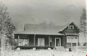
Pontifex family home
https://search.heritageburnaby.ca/link/archivedescription35343
- Repository
- City of Burnaby Archives
- Date
- 1913 (date of original), copied 1986
- Collection/Fonds
- Burnaby Historical Society fonds
- Description Level
- Item
- Physical Description
- 1 photograph : b&w ; 12.7 x 17.8 cm print
- Scope and Content
- Photograph of the Robert Pontifex family home on Douglas Road. Robert and his wife, Beatrix Pontifex, had seven children: Vivien, Helen, Bob, Audrey, Barbara, Basil, and Hugh. Robert built this house with the help of Bernard Hill. The site of this house is now bounded by Century Park Way, Gilpin …
- Repository
- City of Burnaby Archives
- Date
- 1913 (date of original), copied 1986
- Collection/Fonds
- Burnaby Historical Society fonds
- Subseries
- Pioneer Tales subseries
- Physical Description
- 1 photograph : b&w ; 12.7 x 17.8 cm print
- Description Level
- Item
- Record No.
- 204-200
- Access Restriction
- No restrictions
- Reproduction Restriction
- No known restrictions
- Accession Number
- BHS1988-03
- Scope and Content
- Photograph of the Robert Pontifex family home on Douglas Road. Robert and his wife, Beatrix Pontifex, had seven children: Vivien, Helen, Bob, Audrey, Barbara, Basil, and Hugh. Robert built this house with the help of Bernard Hill. The site of this house is now bounded by Century Park Way, Gilpin Street and Canada Way, and became the site of City Hall.
- Subjects
- Buildings - Residential - Houses
- Media Type
- Photograph
- Notes
- Title based on contents of photograph
- Geographic Access
- Canada Way
- Street Address
- 4949 Canada Way
- Historic Neighbourhood
- Burnaby Lake (Historic Neighbourhood)
- Planning Study Area
- Douglas-Gilpin Area
Images

Thank you from City of Burnaby
https://search.heritageburnaby.ca/link/museumdescription15400
- Repository
- Burnaby Village Museum
- Date
- 9 Apr. 2020
- Collection/Fonds
- Burnaby Village Museum COVID-19 collection
- Description Level
- Item
- Physical Description
- 1 video recording (mp4) (58 sec.) : digital, 24 fps, col., sd., stereo
- Scope and Content
- Film clip of Burnaby Mayor Mike Hurley and Burnaby City staff showing their appreciation to frontline workers, first responders and healthcare workers during the COVID-19 pandemic. Burnaby City Hall and other city facilities have decorated windows with colourful hearts and staff members are standin…
- Repository
- Burnaby Village Museum
- Collection/Fonds
- Burnaby Village Museum COVID-19 collection
- Description Level
- Item
- Physical Description
- 1 video recording (mp4) (58 sec.) : digital, 24 fps, col., sd., stereo
- Scope and Content
- Film clip of Burnaby Mayor Mike Hurley and Burnaby City staff showing their appreciation to frontline workers, first responders and healthcare workers during the COVID-19 pandemic. Burnaby City Hall and other city facilities have decorated windows with colourful hearts and staff members are standing outside buildings holding hearts of appreciation. The film closes with people holding hearts and conveying words of thanks in multiple languages.
- History
- Video taken by the City of Burnaby Marketing Department in 2020. The original intent of the clip was to produce communications about the pandemic and changes throughout the City that residents needed to be aware of.
- Creator
- City of Burnaby
- Subjects
- Officials - Mayors and Reeves
- Public Services - Health Services
- Public Services - Municipal Services
- Pandemics - COVID-19
- Geographic Access
- Canada Way
- Street Address
- 4949 Canada Way
- Accession Code
- BV021.2.14
- Access Restriction
- No restrictions
- Reproduction Restriction
- May be restricted by third party rights
- Date
- 9 Apr. 2020
- Media Type
- Moving Images
- Historic Neighbourhood
- Burnaby Lake (Historic Neighbourhood)
- Planning Study Area
- Douglas-Gilpin Area
- Notes
- Title based on contents of film
Images
Video
Thank you from City of Burnaby, 9 Apr. 2020
Thank you from City of Burnaby, 9 Apr. 2020
https://search.heritageburnaby.ca/media/hpo/_Data/_BVM_Moving_Images/2021_0002_0014_001.mp4
Thank you to citizens of Burnaby
https://search.heritageburnaby.ca/link/museumdescription15399
- Repository
- Burnaby Village Museum
- Date
- May 2020
- Collection/Fonds
- Burnaby Village Museum COVID-19 collection
- Description Level
- Item
- Physical Description
- 1 video recording (mp4) (1 min., 37 sec.) : digital, 24 fps, col., sd., stereo
- Scope and Content
- Film clip from the City of Burnaby thanking it's citizens for helping to flatten the curve of the spread of COVID-19 in the community. Mayor Mike Hurley and narrator communicate that commitments made by citizens have helped set the stage for less restrictions whereby some facilities can be reopened…
- Repository
- Burnaby Village Museum
- Collection/Fonds
- Burnaby Village Museum COVID-19 collection
- Description Level
- Item
- Physical Description
- 1 video recording (mp4) (1 min., 37 sec.) : digital, 24 fps, col., sd., stereo
- Scope and Content
- Film clip from the City of Burnaby thanking it's citizens for helping to flatten the curve of the spread of COVID-19 in the community. Mayor Mike Hurley and narrator communicate that commitments made by citizens have helped set the stage for less restrictions whereby some facilities can be reopened in a safe manner by following the guidelines from the Provincial Health Officer, Dr. Bonnie Henry. Film clip includes a compilation of footage taken by the City's marketing department between March and May 2020. Background music "We're all in this together"is written and performed by Joe Keithley and Mayor Mike Hurley.
- History
- Video taken by the City of Burnaby Marketing Department in 2020. The original intent of the clip was to produce communications about the pandemic and changes throughout the City that residents needed to be aware of.
- Creator
- City of Burnaby
- Geographic Access
- Canada Way
- Street Address
- 4949 Canada Way
- Accession Code
- BV021.2.13
- Access Restriction
- No restrictions
- Reproduction Restriction
- May be restricted by third party rights
- Date
- May 2020
- Media Type
- Moving Images
- Historic Neighbourhood
- Burnaby Lake (Historic Neighbourhood)
- Planning Study Area
- Douglas-Gilpin Area
- Notes
- Title based on contents of film
Images
Video
Thank you to citizens of Burnaby, May 2020
Thank you to citizens of Burnaby, May 2020
https://search.heritageburnaby.ca/media/hpo/_Data/_BVM_Moving_Images/2021_0002_0013_001.mp4