More like 'Aerial view of Burnaby Lake'
Narrow Results By
Subject
- Accidents 1
- Accidents - Automobile Accidents 1
- Advertising Medium - Signs and Signboards 38
- Aerial Photographs 131
- Agricultural Tools and Equipment 2
- Agricultural Tools and Equipment - Gardening Equipment 5
- Agricultural Tools and Equipment - Plows 2
- Agriculture 2
- Agriculture - Crops 3
- Agriculture - Farms 13
- Agriculture - Fruit and Berries 4
- Agriculture - Orchards 1
![Aerial view of Vancouver, North Vancouver and West Vancouver, [195-] (date of orignal), copied 1985 thumbnail](/media/hpo/_Data/_BVM_Images/1985/1985_0457_0008_001.jpg?width=280)
Aerial view of Vancouver, North Vancouver and West Vancouver
https://search.heritageburnaby.ca/link/museumdescription10589
- Repository
- Burnaby Village Museum
- Date
- [195-] (date of orignal), copied 1985
- Collection/Fonds
- Burnaby Village Museum Photograph collection
- Description Level
- Item
- Physical Description
- 1 photograph : b&w copy negative ; 10 x 12.5 cm
- Scope and Content
- Aerial photograph looking west towards Vancouver, North Vancouver and West Vancouver.
- Repository
- Burnaby Village Museum
- Collection/Fonds
- Burnaby Village Museum Photograph collection
- Description Level
- Item
- Physical Description
- 1 photograph : b&w copy negative ; 10 x 12.5 cm
- Scope and Content
- Aerial photograph looking west towards Vancouver, North Vancouver and West Vancouver.
- Accession Code
- BV985.457.8
- Access Restriction
- No restrictions
- Reproduction Restriction
- May be restricted by third party rights
- Date
- [195-] (date of orignal), copied 1985
- Media Type
- Photograph
- Scan Resolution
- 1200
- Scan Date
- 2022-06-07
- Photographer
- Aero Surveys Limited
- Notes
- Title based on contents of photograph
Images
![Aerial view of Vancouver, North Vancouver and West Vancouver, [195-] (date of orignal), copied 1985 thumbnail](/media/hpo/_Data/_BVM_Images/1985/1985_0457_0008_001.jpg)
![Burnaby Lake, [193-] thumbnail](/media/hpo/_Data/_Archives_Images/_Unrestricted/001/072-001.jpg?width=280)
Burnaby Lake
https://search.heritageburnaby.ca/link/archivedescription34637
- Repository
- City of Burnaby Archives
- Date
- [193-]
- Collection/Fonds
- Burnaby Historical Society fonds
- Description Level
- Item
- Physical Description
- 1 photograph : b&w ; 12.7 x 20.3 cm
- Scope and Content
- Aerial photograph of Burnaby Lake and North Burnaby.
- Repository
- City of Burnaby Archives
- Date
- [193-]
- Collection/Fonds
- Burnaby Historical Society fonds
- Subseries
- Photographs subseries
- Physical Description
- 1 photograph : b&w ; 12.7 x 20.3 cm
- Description Level
- Item
- Record No.
- 072-001
- Access Restriction
- No restrictions
- Reproduction Restriction
- No known restrictions
- Accession Number
- BHS2007-04
- Scope and Content
- Aerial photograph of Burnaby Lake and North Burnaby.
- Media Type
- Photograph
- Notes
- Title based on contents of photograph
- Geographic Access
- Burnaby Lake
- Historic Neighbourhood
- Burnaby Lake (Historic Neighbourhood)
- Lozells (Historic Neighbourhood)
- Lochdale (Historic Neighbourhood)
- Planning Study Area
- Parkcrest-Aubrey Area
- Ardingley-Sprott Area
- Burnaby Lake Area
- Government Road Area
- Sperling-Broadway Area
- Lochdale Area
Images
![Burnaby Lake, [193-] thumbnail](/media/hpo/_Data/_Archives_Images/_Unrestricted/001/072-001.jpg)

Burnaby Lake rowing course dredging
https://search.heritageburnaby.ca/link/archivedescription38303
- Repository
- City of Burnaby Archives
- Date
- 1971
- Collection/Fonds
- Burnaby Historical Society fonds
- Description Level
- Item
- Physical Description
- 1 photograph : col. ; 12.5 x 18 cm
- Scope and Content
- Aerial photograph of the Burnaby Lake rowing course being dredged in 1971, in preparation for the 1973 Canada Summer Games.
- Repository
- City of Burnaby Archives
- Date
- 1971
- Collection/Fonds
- Burnaby Historical Society fonds
- Subseries
- Photographs subseries
- Physical Description
- 1 photograph : col. ; 12.5 x 18 cm
- Description Level
- Item
- Record No.
- 400-001
- Access Restriction
- No restrictions
- Reproduction Restriction
- Reproduce for fair dealing purposes only
- Accession Number
- BHS2007-04
- Scope and Content
- Aerial photograph of the Burnaby Lake rowing course being dredged in 1971, in preparation for the 1973 Canada Summer Games.
- Media Type
- Photograph
- Notes
- Title based on contents of photograph
- Geographic Access
- Roberts Street
- Burnaby Lake
- Street Address
- 6871 Roberts Street
- Historic Neighbourhood
- Burnaby Lake (Historic Neighbourhood)
- Planning Study Area
- Burnaby Lake Area
Images

![Deer Lake and Sperling Avenue, [1946] (date of original), copied 1991 thumbnail](/media/hpo/_Data/_Archives_Images/_Unrestricted/370/370-533.jpg?width=280)
Deer Lake and Sperling Avenue
https://search.heritageburnaby.ca/link/archivedescription37946
- Repository
- City of Burnaby Archives
- Date
- [1946] (date of original), copied 1991
- Collection/Fonds
- Burnaby Historical Society fonds
- Description Level
- Item
- Physical Description
- 1 photograph : b&w ; 3.5 x 4.4 cm print on contact sheet 20.5 x 26.7 cm
- Scope and Content
- Aerial photograph of Deer Lake and the Sperling Avenue area facing north.
- Repository
- City of Burnaby Archives
- Date
- [1946] (date of original), copied 1991
- Collection/Fonds
- Burnaby Historical Society fonds
- Subseries
- Burnaby Image Bank subseries
- Physical Description
- 1 photograph : b&w ; 3.5 x 4.4 cm print on contact sheet 20.5 x 26.7 cm
- Description Level
- Item
- Record No.
- 370-533
- Access Restriction
- No restrictions
- Reproduction Restriction
- No known restrictions
- Accession Number
- BHS1999-03
- Scope and Content
- Aerial photograph of Deer Lake and the Sperling Avenue area facing north.
- Media Type
- Photograph
- Notes
- Title based on contents of photograph
- 1 b&w copy negative accompanying
- Negative has a pink cast
- Geographic Access
- Deer Lake
- Sperling Avenue
- Historic Neighbourhood
- Burnaby Lake (Historic Neighbourhood)
- Planning Study Area
- Morley-Buckingham Area
Images
![Deer Lake and Sperling Avenue, [1946] (date of original), copied 1991 thumbnail](/media/hpo/_Data/_Archives_Images/_Unrestricted/370/370-533.jpg)
![Burnaby Mountain, [between 1958 and 1965] (date of original), copied 1991 thumbnail](/media/hpo/_Data/_Archives_Images/_Unrestricted/370/370-797.jpg?width=280)
Burnaby Mountain
https://search.heritageburnaby.ca/link/archivedescription38210
- Repository
- City of Burnaby Archives
- Date
- [between 1958 and 1965] (date of original), copied 1991
- Collection/Fonds
- Burnaby Historical Society fonds
- Description Level
- Item
- Physical Description
- 1 photograph : b&w ; 3.2 x 5.1 cm print on contact sheet 20.5 x 26.8 cm
- Scope and Content
- Aerial photograph of Centennial Park, Burnaby Mountain and Burrard Inlet looking east.
- Repository
- City of Burnaby Archives
- Date
- [between 1958 and 1965] (date of original), copied 1991
- Collection/Fonds
- Burnaby Historical Society fonds
- Subseries
- Burnaby Image Bank subseries
- Physical Description
- 1 photograph : b&w ; 3.2 x 5.1 cm print on contact sheet 20.5 x 26.8 cm
- Description Level
- Item
- Record No.
- 370-797
- Access Restriction
- No restrictions
- Reproduction Restriction
- No restrictions
- Accession Number
- BHS1999-03
- Scope and Content
- Aerial photograph of Centennial Park, Burnaby Mountain and Burrard Inlet looking east.
- Subjects
- Aerial Photographs
- Geographic Features - Inlets
- Geographic Features - Mountains
- Geographic Features - Parks
- Media Type
- Photograph
- Notes
- Title based on contents of photograph
- 1 b&w copy negative accompanying
- Geographic Access
- Burnaby Mountain Conservation Area
- Planning Study Area
- Burnaby Mountain Area
Images
![Burnaby Mountain, [between 1958 and 1965] (date of original), copied 1991 thumbnail](/media/hpo/_Data/_Archives_Images/_Unrestricted/370/370-797.jpg)
![Burnaby creek conservationists, [2002] thumbnail](/media/hpo/_Data/_Archives_Images/_Unrestricted/535/535-1959-1.jpg?width=280)
Burnaby creek conservationists
https://search.heritageburnaby.ca/link/archivedescription96276
- Repository
- City of Burnaby Archives
- Date
- [2002]
- Collection/Fonds
- Burnaby NewsLeader photograph collection
- Description Level
- File
- Physical Description
- 4 photographs (tiff) : col.
- Scope and Content
- File contains photographs of volunteer conservationists with the Eagle Creek Streamkeepers, Byrne Creek Streamkeepers, and Sapperton Fish & Game Club at work in the Lake City area by Eagle Creek and the Brunette River. Photographs depict Nick Kvenich, of the Eagle Creek Streamkeepers, in a creek; m…
- Repository
- City of Burnaby Archives
- Date
- [2002]
- Collection/Fonds
- Burnaby NewsLeader photograph collection
- Physical Description
- 4 photographs (tiff) : col.
- Description Level
- File
- Record No.
- 535-1959
- Access Restriction
- No restrictions
- Reproduction Restriction
- No restrictions
- Accession Number
- 2018-12
- Scope and Content
- File contains photographs of volunteer conservationists with the Eagle Creek Streamkeepers, Byrne Creek Streamkeepers, and Sapperton Fish & Game Club at work in the Lake City area by Eagle Creek and the Brunette River. Photographs depict Nick Kvenich, of the Eagle Creek Streamkeepers, in a creek; members of the Byrne Creek Streamkeepers observing a storm drain; and Elmer Rudolf feeding fish at a Sapperton Fish & Game Club hatchery.
- Subjects
- Geographic Features - Creeks
- Geographic Features - Lakes and Ponds
- Geographic Features - Ravines
- Geographic Features - Streams
- Media Type
- Photograph
- Photographer
- Bartel, Mario
- Notes
- Title based on caption
- Collected by editorial for use in a March 2002 issue of the Burnaby NewsLeader
- Caption from metadata for 535-1959-1: "Nick Kvenich is one of the founding members of the Eagle Creek Streamkeepers, which is looking to preserve the habitat of the creek that runs down from Squint Lake into a ravine below the Lake City industrial area."
- Caption from metadata for 535-1959-2: "Joan Carne (r) and Louise Towell, of the Byrne Creek Streamkeepers, examine a storm drain in an industrial area above the creek. The habitat faces constant pressure from businesses and homeowners who pour solvents, soaps and substances into the drains without thought to the consequences."
- Caption from metadata for 535-1959-3: "Nick Kvenich, one of the founding members of the Eagle Creek Streamkeepers, climbs through a fallen tree that is blocking a trail that runs alongside the creek, in a ravine below the Lake City industrial area. Although the tree will eventually be cleared by the GVRD, Kvenich says he prefers if such obstacles be left alone, as they would discourage people who might abuse the habitat."
- Caption from metadata for 535-1959-4: "Elmer Rudolf feeds a new batch of coho fry at the Sapperton Fish & Game Club's hatchery, near the Brunette River. The fry are normally fed by a timed conveyor belt, but that is supplemented by hand feedings to give the weaker fish a chance."
- Geographic Access
- Brunette River
- Eagle Creek
- Planning Study Area
- Lake City Area
Images
![Burnaby creek conservationists, [2002] thumbnail](/media/hpo/_Data/_Archives_Images/_Unrestricted/535/535-1959-1.jpg)
![Kingsway and Central Park, [196-] thumbnail](/media/hpo/_Data/_Archives_Images/_Unrestricted/001/083-001.jpg?width=280)
Kingsway and Central Park
https://search.heritageburnaby.ca/link/archivedescription34658
- Repository
- City of Burnaby Archives
- Date
- [196-]
- Collection/Fonds
- Burnaby Historical Society fonds
- Description Level
- Item
- Physical Description
- 1 photograph : b&w ; 14.5 x 19.4 cm
- Scope and Content
- Aerial photograph of Kingsway and Central Park.
- Repository
- City of Burnaby Archives
- Date
- [196-]
- Collection/Fonds
- Burnaby Historical Society fonds
- Subseries
- Photographs subseries
- Physical Description
- 1 photograph : b&w ; 14.5 x 19.4 cm
- Description Level
- Item
- Record No.
- 083-001
- Access Restriction
- No restrictions
- Reproduction Restriction
- Reproduce for fair dealing purposes only
- Accession Number
- BHS2007-04
- Scope and Content
- Aerial photograph of Kingsway and Central Park.
- Media Type
- Photograph
- Notes
- Title based on contents of photograph
- Geographic Access
- Kingsway
- Central Park
- Historic Neighbourhood
- Central Park (Historic Neighbourhood)
- Planning Study Area
- Maywood Area
Images
![Kingsway and Central Park, [196-] thumbnail](/media/hpo/_Data/_Archives_Images/_Unrestricted/001/083-001.jpg)
![Lower Mainland, [1946] thumbnail](/media/hpo/_Data/_Archives_Images/_Unrestricted/485/486-039.jpg?width=280)
Lower Mainland
https://search.heritageburnaby.ca/link/archivedescription55645
- Repository
- City of Burnaby Archives
- Date
- [1946]
- Collection/Fonds
- Charles MacSorley fonds
- Description Level
- Item
- Physical Description
- 1 photograph : b&w ; 20.5 x 25.5 cm
- Scope and Content
- Aerial photograph of the Lower Mainland of British Columbia, looking east over Stanley Park and the Burrard Inlet. A printed description accompanying the photograph reads: "A view of the Lower Mainland taken along Burrard Inlet. The block of land in the lower centre of the photograph is Stanley Par…
- Repository
- City of Burnaby Archives
- Date
- [1946]
- Collection/Fonds
- Charles MacSorley fonds
- Physical Description
- 1 photograph : b&w ; 20.5 x 25.5 cm
- Description Level
- Item
- Record No.
- 486-039
- Access Restriction
- No restrictions
- Reproduction Restriction
- No known restrictions
- Accession Number
- 2005-14
- Scope and Content
- Aerial photograph of the Lower Mainland of British Columbia, looking east over Stanley Park and the Burrard Inlet. A printed description accompanying the photograph reads: "A view of the Lower Mainland taken along Burrard Inlet. The block of land in the lower centre of the photograph is Stanley Park with the business section of the City of Vancouver connected thereto. To the left of the Inlet is the City and District of North Vancouver and just above Vancouver is the District of Burnaby. The mountains at the extreme top of the photograph are the Coastal Range and are over a hundred miles away. The mountains to the left can be reached by a fifteen-minute drive from the city. Presented with the compliments of the Corporation of the District of Burnaby."
- Media Type
- Photograph
- Notes
- Title based on caption
- Caption on recto reads: "Lower Mainland"
- Printed description adhered to verso of photograph
Images
![Lower Mainland, [1946] thumbnail](/media/hpo/_Data/_Archives_Images/_Unrestricted/485/486-039.jpg)
![North Burnaby, [1959] thumbnail](/media/hpo/_Data/_Archives_Images/_Unrestricted/001/106-001.jpg?width=280)
North Burnaby
https://search.heritageburnaby.ca/link/archivedescription34701
- Repository
- City of Burnaby Archives
- Date
- [1959]
- Collection/Fonds
- Burnaby Historical Society fonds
- Description Level
- Item
- Physical Description
- 1 photograph : b&w ; 16.6 x 20.5 cm
- Scope and Content
- Aerial photograph of North Burnaby and Burrard Inlet looking west.
- Repository
- City of Burnaby Archives
- Date
- [1959]
- Collection/Fonds
- Burnaby Historical Society fonds
- Subseries
- Photographs subseries
- Physical Description
- 1 photograph : b&w ; 16.6 x 20.5 cm
- Description Level
- Item
- Record No.
- 106-001
- Access Restriction
- No restrictions
- Reproduction Restriction
- Reproduce for fair dealing purposes only
- Accession Number
- BHS2007-04
- Scope and Content
- Aerial photograph of North Burnaby and Burrard Inlet looking west.
- Media Type
- Photograph
- Notes
- Title based on contents of photograph
- Historic Neighbourhood
- Vancouver Heights (Historic Neighbourhood)
- Capitol Hill (Historic Neighbourhood)
- Lochdale (Historic Neighbourhood)
- Planning Study Area
- Burnaby Heights Area
- Capitol Hill Area
- Westridge Area
- Willingdon Heights Area
- Brentwood Area
- Parkcrest-Aubrey Area
- Lochdale Area
Images
![North Burnaby, [1959] thumbnail](/media/hpo/_Data/_Archives_Images/_Unrestricted/001/106-001.jpg)
![Byrne Creek Streamkeepers, [2001] thumbnail](/media/hpo/_Data/_Archives_Images/_Unrestricted/535/535-2194-1.jpg?width=280)
Byrne Creek Streamkeepers
https://search.heritageburnaby.ca/link/archivedescription96572
- Repository
- City of Burnaby Archives
- Date
- [2001]
- Collection/Fonds
- Burnaby NewsLeader photograph collection
- Description Level
- File
- Physical Description
- 2 photographs (tiff) : col.
- Scope and Content
- File contains members of the Byrne Creek Streamkeepers during their work to protect the waterways and salmon in the area. Photographs depict Bob Fuller checking a waterflow measuring gauge and Joan Carne standing in the overflow channel at the salmon rearing ponds below Marine Drive.
- Repository
- City of Burnaby Archives
- Date
- [2001]
- Collection/Fonds
- Burnaby NewsLeader photograph collection
- Physical Description
- 2 photographs (tiff) : col.
- Description Level
- File
- Record No.
- 535-2194
- Access Restriction
- No restrictions
- Reproduction Restriction
- No restrictions
- Accession Number
- 2018-12
- Scope and Content
- File contains members of the Byrne Creek Streamkeepers during their work to protect the waterways and salmon in the area. Photographs depict Bob Fuller checking a waterflow measuring gauge and Joan Carne standing in the overflow channel at the salmon rearing ponds below Marine Drive.
- Subjects
- Persons - Volunteers
- Geographic Features - Creeks
- Geographic Features - Lakes and Ponds
- Geographic Features - Streams
- Media Type
- Photograph
- Photographer
- Bartel, Mario
- Notes
- Title based on caption
- Collected by editorial for use in a March 2001 issue of the Burnaby NewsLeader
- Caption from metadata for 535-2194-1: "Bob Fuller, of the Byrne Creek Streamkeepers, checks the guage that measures the flow of water which is released from the holding pond below Marine Drive to the salmon spawning beds downstream."
- Caption from metadata for 535-2194-2: "Joan Carne of the Byrne Creek Streamkeepers stands in the overflow channel at the salmon rearing ponds below Marine Drive. Although last week's chemical spill into Byrne Creek didn't reach the ponds, Carne says it's a constant battle to educate people to take care of the area's creeks and streams."
- Geographic Access
- Marine Drive
- Byrne Creek
- Planning Study Area
- Stride Hill Area
Images
![Byrne Creek Streamkeepers, [2001] thumbnail](/media/hpo/_Data/_Archives_Images/_Unrestricted/535/535-2194-1.jpg)

Canada geese in the park
https://search.heritageburnaby.ca/link/archivedescription59046
- Repository
- City of Burnaby Archives
- Date
- ca.1983
- Collection/Fonds
- Columbian Newspaper collection
- Description Level
- Item
- Physical Description
- 1 photograph : b&w ; 17.5 x 20 cm
- Scope and Content
- Photograph of a flock of Canada geese on a grassy field in a park.
- Repository
- City of Burnaby Archives
- Date
- ca.1983
- Collection/Fonds
- Columbian Newspaper collection
- Physical Description
- 1 photograph : b&w ; 17.5 x 20 cm
- Description Level
- Item
- Record No.
- 480-1452
- Access Restriction
- No restrictions
- Reproduction Restriction
- May be restricted by third party rights
- Accession Number
- 2009-01
- Scope and Content
- Photograph of a flock of Canada geese on a grassy field in a park.
- Subjects
- Geographic Features - Fields
- Geographic Features - Lakes and Ponds
- Geographic Features - Parks
- Animals - Birds
- Media Type
- Photograph
- Photographer
- Battistoni, Peter
- Notes
- Title based on contents of photograph
- Photographer's stamp on verso
- Note on verso reads: "page 4 / Burnaby / Today / PMT 100%"
Images


Deer Lake Gibraltar
https://search.heritageburnaby.ca/link/archivedescription34312
- Repository
- City of Burnaby Archives
- Date
- 1924
- Collection/Fonds
- Burnaby Historical Society fonds
- Description Level
- Item
- Physical Description
- 1 photograph : b&w ; 8.1 x 13.2 cm
- Scope and Content
- Photograph of the "Gibraltar" rock at mouth of Deer Lake Creek. This photograph was taken during the winter of 1924 and the lake is frozen over with ice. The surface of the lake is covered with marks made by ice skates. Deer Lake Creek is historically known as Deer Lake Brook.
- Repository
- City of Burnaby Archives
- Date
- 1924
- Collection/Fonds
- Burnaby Historical Society fonds
- Subseries
- Peers family subseries
- Physical Description
- 1 photograph : b&w ; 8.1 x 13.2 cm
- Description Level
- Item
- Record No.
- 020-019
- Access Restriction
- No restrictions
- Reproduction Restriction
- No known restrictions
- Accession Number
- BHS2007-04
- Scope and Content
- Photograph of the "Gibraltar" rock at mouth of Deer Lake Creek. This photograph was taken during the winter of 1924 and the lake is frozen over with ice. The surface of the lake is covered with marks made by ice skates. Deer Lake Creek is historically known as Deer Lake Brook.
- Subjects
- Geographic Features - Creeks
- Geographic Features - Lakes and Ponds
- Geographic Features - Rock Formations
- Media Type
- Photograph
- Notes
- Title based on caption accompanying photograph
- Geographic Access
- Deer Lake Brook
- Historic Neighbourhood
- Burnaby Lake (Historic Neighbourhood)
- Planning Study Area
- Morley-Buckingham Area
Images

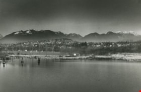
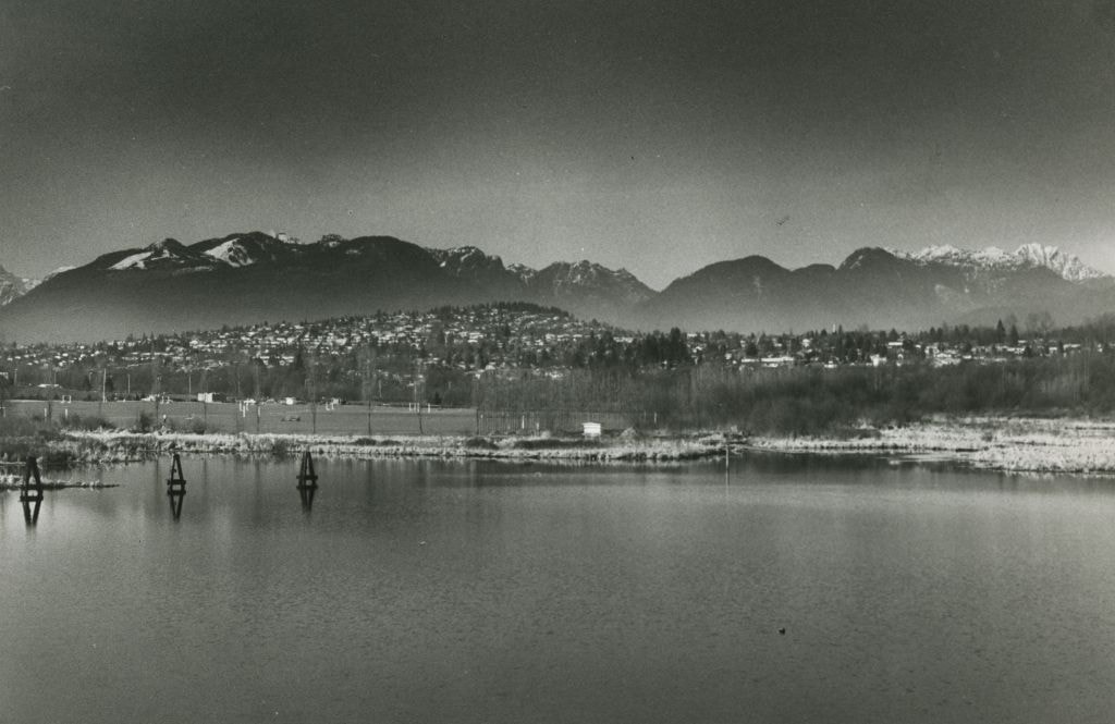
View of a Lake, City, and Mountains
https://search.heritageburnaby.ca/link/archivedescription59024
- Repository
- City of Burnaby Archives
- Date
- ca.1983
- Collection/Fonds
- Columbian Newspaper collection
- Description Level
- Item
- Physical Description
- 1 photograph : b&w
- Scope and Content
- Photograph of a lake and residential neighbourhood, with the North Shore mountains in the background.
- Repository
- City of Burnaby Archives
- Date
- ca.1983
- Collection/Fonds
- Columbian Newspaper collection
- Physical Description
- 1 photograph : b&w
- Description Level
- Item
- Record No.
- 480-1430
- Access Restriction
- No restrictions
- Reproduction Restriction
- May be restricted by third party rights
- Accession Number
- 2009-01
- Scope and Content
- Photograph of a lake and residential neighbourhood, with the North Shore mountains in the background.
- Subjects
- Geographic Features - Beaches
- Geographic Features - Lakes and Ponds
- Geographic Features - Mountains
- Media Type
- Photograph
- Photographer
- King, Basil
- Notes
- Title based on contents of photograph
Images

Adults and children at Deer Lake Park
https://search.heritageburnaby.ca/link/archivedescription59007
- Repository
- City of Burnaby Archives
- Date
- ca.1983
- Collection/Fonds
- Columbian Newspaper collection
- Description Level
- Item
- Physical Description
- 1 photograph : b&w ; 20.5 x 25.5 cm
- Scope and Content
- Photograph of adults and children having a picnic on the beach at Deer Lake Park.
- Repository
- City of Burnaby Archives
- Date
- ca.1983
- Collection/Fonds
- Columbian Newspaper collection
- Physical Description
- 1 photograph : b&w ; 20.5 x 25.5 cm
- Description Level
- Item
- Record No.
- 480-1416
- Access Restriction
- No restrictions
- Reproduction Restriction
- May be restricted by third party rights
- Accession Number
- 2009-01
- Scope and Content
- Photograph of adults and children having a picnic on the beach at Deer Lake Park.
- Subjects
- Recreational Activities - Picnics
- Geographic Features - Lakes and Ponds
- Geographic Features - Beaches
- Persons - Children
- Media Type
- Photograph
- Photographer
- King, Basil
- Notes
- Title based on contents of photograph
- Photographer's stamp on verso
- Note on verso reads: "PMT 120% / page 10 / Burnaby / Today"
- Geographic Access
- Deer Lake Park
- Historic Neighbourhood
- Burnaby Lake (Historic Neighbourhood)
- Planning Study Area
- Douglas-Gilpin Area
Images

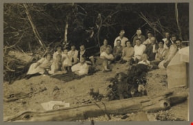
Alouette Lake
https://search.heritageburnaby.ca/link/archivedescription82611
- Repository
- City of Burnaby Archives
- Date
- June 21, 1925
- Collection/Fonds
- Hill family and Vidal family fonds
- Description Level
- Item
- Physical Description
- 1 photograph : sepia, mounted on cardboard ; 12.5 x 17 cm
- Scope and Content
- Photograph is a portrait of men, women, and children on the beach of Alouette Lake. The fourth woman from the left is identified as Charlotte Hill. The man to the right of her is identified as Minard Hill.
- Repository
- City of Burnaby Archives
- Date
- June 21, 1925
- Collection/Fonds
- Hill family and Vidal family fonds
- Physical Description
- 1 photograph : sepia, mounted on cardboard ; 12.5 x 17 cm
- Description Level
- Item
- Record No.
- 550-175
- Access Restriction
- No restrictions
- Reproduction Restriction
- No known restrictions
- Accession Number
- 2013-03
- Scope and Content
- Photograph is a portrait of men, women, and children on the beach of Alouette Lake. The fourth woman from the left is identified as Charlotte Hill. The man to the right of her is identified as Minard Hill.
- Media Type
- Photograph
- Notes
- Title based on note accompanying photograph
- Note in black pen on the cardboard reads: "Alouette Lake / June 21, 1925"
- Accompanying newspaper clipping attached to album page is titled "Surveyors' Examinations"
Images

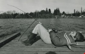
Boy fishing on a lake
https://search.heritageburnaby.ca/link/archivedescription59003
- Repository
- City of Burnaby Archives
- Date
- ca.1983
- Collection/Fonds
- Columbian Newspaper collection
- Description Level
- Item
- Physical Description
- 1 photograph : b&w ; 17 x 25.5 cm
- Scope and Content
- Photograph of a boy laying on a dock next to a lake; his fishing rod is propped up by a stick. A beach and playground are visible in the background.
- Repository
- City of Burnaby Archives
- Date
- ca.1983
- Collection/Fonds
- Columbian Newspaper collection
- Physical Description
- 1 photograph : b&w ; 17 x 25.5 cm
- Description Level
- Item
- Record No.
- 480-1412
- Access Restriction
- No restrictions
- Reproduction Restriction
- May be restricted by third party rights
- Accession Number
- 2009-01
- Scope and Content
- Photograph of a boy laying on a dock next to a lake; his fishing rod is propped up by a stick. A beach and playground are visible in the background.
- Subjects
- Persons - Children
- Geographic Features - Lakes and Ponds
- Geographic Features - Beaches
- Recreational Activities - Fishing
- Media Type
- Photograph
- Photographer
- Hodge, Craig
- Notes
- Title based on contents of photograph
- Photographer's stamp on verso
- Note on verso reads: "PMT 76% / page A-4 / Burnaby Today"
Images


Burnaby Lake
https://search.heritageburnaby.ca/link/archivedescription34563
- Repository
- City of Burnaby Archives
- Date
- 1923
- Collection/Fonds
- Burnaby Historical Society fonds
- Description Level
- Item
- Physical Description
- 1 photograph : b&w ; 17.4 x 35.3 cm
- Scope and Content
- Photograph of Burnaby Lake, looking northwest. The north shore mountains, including The Lions, can be seen in the background.
- Repository
- City of Burnaby Archives
- Date
- 1923
- Collection/Fonds
- Burnaby Historical Society fonds
- Subseries
- Photographs subseries
- Physical Description
- 1 photograph : b&w ; 17.4 x 35.3 cm
- Description Level
- Item
- Record No.
- 050-001
- Access Restriction
- No restrictions
- Reproduction Restriction
- No known restrictions
- Accession Number
- BHS2007-04
- Scope and Content
- Photograph of Burnaby Lake, looking northwest. The north shore mountains, including The Lions, can be seen in the background.
- Media Type
- Photograph
- Notes
- Title based on contents of photograph
- Geographic Access
- Burnaby Lake
- Historic Neighbourhood
- Burnaby Lake (Historic Neighbourhood)
- Planning Study Area
- Burnaby Lake Area
Images


Burnaby Lake Pilot Dredging Project
https://search.heritageburnaby.ca/link/archivedescription91710
- Repository
- City of Burnaby Archives
- Date
- August 1999 - September 1999
- Collection/Fonds
- Doreen Lawson fonds
- Description Level
- File
- Physical Description
- 19 photographs : col. slides ; 35 mm
- Scope and Content
- File consists of photographs documenting the Burnaby Lake Pilot Dredging Project undertaken by the City of Burnaby between August 20 and September 16, 1999. Photographs depict silt-laded water in Still Creek prior to the dredging, mechanical dredging equipment on land and in use on the lake, and t…
- Repository
- City of Burnaby Archives
- Date
- August 1999 - September 1999
- Collection/Fonds
- Doreen Lawson fonds
- Physical Description
- 19 photographs : col. slides ; 35 mm
- Description Level
- File
- Record No.
- 618-029
- Access Restriction
- No restrictions
- Reproduction Restriction
- No restrictions
- Accession Number
- 2015-15
- Scope and Content
- File consists of photographs documenting the Burnaby Lake Pilot Dredging Project undertaken by the City of Burnaby between August 20 and September 16, 1999. Photographs depict silt-laded water in Still Creek prior to the dredging, mechanical dredging equipment on land and in use on the lake, and the adjacent water treatment facility. Also contained in the file are photographs of Deputy Director of Engineering, Lambert Chu, speaking at the dredging site and vials containing two water samples: one clear and one opaque with brown sediment.
- Media Type
- Photograph
- Photographer
- Lawson, Doreen A.
- Notes
- Title based on contents of photographs
- Geographic Access
- Burnaby Lake
- Still Creek
- Historic Neighbourhood
- Burnaby Lake (Historic Neighbourhood)
- Planning Study Area
- Burnaby Lake Area
Images


Burnaby Lake Show / originals
https://search.heritageburnaby.ca/link/archivedescription91683
- Repository
- City of Burnaby Archives
- Date
- 1962-1995
- Collection/Fonds
- Doreen Lawson fonds
- Description Level
- File
- Physical Description
- 71 photographs : col. slides ; 35 mm
- Scope and Content
- File consists of photographs compiled by Doreen Lawson for a slideshow presentation about Burnaby Lake. Slideshow primarily depicts the wildlife and foliage of Burnaby Lake, including: the American coot, green-winged teal, bufflehead, heron, american bittern, barn swallow, barn owl, painted turtle,…
- Repository
- City of Burnaby Archives
- Date
- 1962-1995
- Collection/Fonds
- Doreen Lawson fonds
- Physical Description
- 71 photographs : col. slides ; 35 mm
- Description Level
- File
- Record No.
- 618-001
- Access Restriction
- No restrictions
- Reproduction Restriction
- May be restricted by third party rights
- Accession Number
- 2015-15
- Scope and Content
- File consists of photographs compiled by Doreen Lawson for a slideshow presentation about Burnaby Lake. Slideshow primarily depicts the wildlife and foliage of Burnaby Lake, including: the American coot, green-winged teal, bufflehead, heron, american bittern, barn swallow, barn owl, painted turtle, muskrat, Canadian goose, beaver, wood duck, bullrushes, yellow and white waterlilies, yellow iris, and loosestrife. Also included in the slideshow are photographs of the BC Wildlife rescue and fisherman working in the Brunette River.
- Subjects
- Geographic Features - Lakes and Ponds
- Animals - Birds
- Animals
- Geographic Features - Forests
- Media Type
- Photograph
- Photographer
- Lawson, Doreen A.
- Chapman, Fred
- Notes
- Transcribed title
- Title transcribed from sheets slides
- Photographs contents are identified on many of the slide cases within the file.
- Historic Neighbourhood
- Burnaby Lake (Historic Neighbourhood)
- Planning Study Area
- Burnaby Lake Area
Images


Burnaby Lake slide show
https://search.heritageburnaby.ca/link/archivedescription91684
- Repository
- City of Burnaby Archives
- Date
- 1976-1999
- Collection/Fonds
- Doreen Lawson fonds
- Description Level
- File
- Physical Description
- 85 photographs : col. slides ; 35 mm
- Scope and Content
- File consists of photographs compiled by Doreen Lawson for slideshow presentations about Burnaby Lake. Slideshow primarily depicts the wildlife and foliage of Burnaby Lake, including: the painted turtle, heron, American coot, coyote, barn owl, rainbow fry, Canadian goose, and beaver, as well as a v…
- Repository
- City of Burnaby Archives
- Date
- 1976-1999
- Collection/Fonds
- Doreen Lawson fonds
- Physical Description
- 85 photographs : col. slides ; 35 mm
- Description Level
- File
- Record No.
- 618-002
- Access Restriction
- No restrictions
- Reproduction Restriction
- May be restricted by third party rights
- Accession Number
- 2015-15
- Scope and Content
- File consists of photographs compiled by Doreen Lawson for slideshow presentations about Burnaby Lake. Slideshow primarily depicts the wildlife and foliage of Burnaby Lake, including: the painted turtle, heron, American coot, coyote, barn owl, rainbow fry, Canadian goose, and beaver, as well as a variety of scenic photographs of the Burnaby Lake shoreline with mountains and the Metrotown skyline in distance. Also included in file are photographs of people canoeing, kayaking, feeding geese, and participating in conservation activities including fencing trees and testing water levels. Photographs also depict the pipeline leading into Burnaby Lake, lake dredging equipment, and an oil slick.
- Subjects
- Geographic Features - Lakes and Ponds
- Animals - Birds
- Animals
- Geographic Features - Forests
- Media Type
- Photograph
- Photographer
- Lawson, Doreen A.
- Notes
- Title based on contents of photographs
- Note in black ink on recto of slide sheet photographs 618-002-1 : 618-002-9 originally housed in read: "Burnby Lake Slideshow"
- Note in black ink on recto of slide sheet photographs 618-002-10 : 608-002-19 originally housed in read: "Burnaby Lake / Rejects (My Fav!)"
- Photographs contents are identified on many of the slide cases within the file.
- Historic Neighbourhood
- Burnaby Lake (Historic Neighbourhood)
- Planning Study Area
- Burnaby Lake Area
Images
