Narrow Results By
Subject
- Agricultural Tools and Equipment - Plows 3
- Agriculture 1
- Agriculture - Farms 4
- Animals - Birds 4
- Animals - Cows 1
- Animals - Fish 1
- Buildings - Commercial - Automobile Dealerships 1
- Buildings - Commercial - Restaurants 1
- Buildings - Commercial - Stores 1
- Buildings - Industrial 1
- Buildings - Residential - Houses 1
- Buildings - Schools 1
Person / Organization
- Avendaño, Adrian 1
- Boundary Road Lumber Mill 1
- British Columbia Electric Railway Company 2
- Burnaby Fire Department 1
- Burnaby Lake Park Association 1
- Burnaby Village Museum 2
- Ceperley, H.T. 2
- Chan, Puy Yuen 2
- Gnome Publications 1
- Green, George 1
- Hart, Frederick John, 1884-1945 2
- Haszard, Arthur de Windt 2
10 Foot Planking be Laid for a Distance of 10 chs. on Pole Line Road South of Still Creek
https://search.heritageburnaby.ca/link/councilreport76815
- Repository
- City of Burnaby Archives
- Report ID
- 81399
- Meeting Date
- 19-Mar-1910
- Format
- Council - Mayor/Councillor/Staff Report
- Collection/Fonds
- City Council and Office of the City Clerk fonds
- Repository
- City of Burnaby Archives
- Report ID
- 81399
- Meeting Date
- 19-Mar-1910
- Format
- Council - Mayor/Councillor/Staff Report
- Collection/Fonds
- City Council and Office of the City Clerk fonds
Documents
2238 South Gilmore Ave
https://search.heritageburnaby.ca/link/archivedescription94329
- Repository
- City of Burnaby Archives
- Date
- 1995
- Collection/Fonds
- Grover, Elliott & Co. Ltd. fonds
- Description Level
- File
- Physical Description
- 36 photographs : col. negatives ; 35 mm
- Scope and Content
- Photographs of a truck trailor parking lot located at 2238 Gilmore Avenue (an address that no longer exists) and the surrounding industrial area of Gilmore Avenue and Henning Drive. File also includes photographs of the Gilmore Avenue railroad crossing one block north of Still Creek Avenue.
- Repository
- City of Burnaby Archives
- Date
- 1995
- Collection/Fonds
- Grover, Elliott & Co. Ltd. fonds
- Physical Description
- 36 photographs : col. negatives ; 35 mm
- Description Level
- File
- Record No.
- 622-114
- Access Restriction
- No restrictions
- Reproduction Restriction
- No restrictions
- Accession Number
- 2017-39
- Scope and Content
- Photographs of a truck trailor parking lot located at 2238 Gilmore Avenue (an address that no longer exists) and the surrounding industrial area of Gilmore Avenue and Henning Drive. File also includes photographs of the Gilmore Avenue railroad crossing one block north of Still Creek Avenue.
- Media Type
- Photograph
- Notes
- Transcribed title
- Title transcribed from envelope photographs were originally housed in
- File no. 95-027-B
- Geographic Access
- Gilmore Avenue
- Historic Neighbourhood
- Broadview (Historic Neighbourhood)
- Planning Study Area
- West Central Valley Area
5088 Still Creek Avenue
https://search.heritageburnaby.ca/link/councilreport38904
- Repository
- City of Burnaby Archives
- Report ID
- 35369
- Meeting Date
- 17-Sep-1962
- Format
- Council - Manager's Report
- Manager's Report No.
- 49
- Item No.
- 2
- Collection/Fonds
- City Council and Office of the City Clerk fonds
- Repository
- City of Burnaby Archives
- Report ID
- 35369
- Meeting Date
- 17-Sep-1962
- Format
- Council - Manager's Report
- Manager's Report No.
- 49
- Item No.
- 2
- Collection/Fonds
- City Council and Office of the City Clerk fonds
Documents
5352 Still Creek Street
https://search.heritageburnaby.ca/link/councilreport20803
- Repository
- City of Burnaby Archives
- Report ID
- 13941
- Meeting Date
- 25-Jun-1979
- Format
- Council - Committee Report
- Collection/Fonds
- City Council and Office of the City Clerk fonds
- Repository
- City of Burnaby Archives
- Report ID
- 13941
- Meeting Date
- 25-Jun-1979
- Format
- Council - Committee Report
- Collection/Fonds
- City Council and Office of the City Clerk fonds
Documents
Allowing for Extra Cribbing Work to be Done at Still Creek and to Extend Three Chains from the Bridge Northwords
https://search.heritageburnaby.ca/link/councilreport78460
- Repository
- City of Burnaby Archives
- Report ID
- 82530
- Meeting Date
- 7-Apr-1894
- Format
- Council - Mayor/Councillor/Staff Report
- Collection/Fonds
- City Council and Office of the City Clerk fonds
- Repository
- City of Burnaby Archives
- Report ID
- 82530
- Meeting Date
- 7-Apr-1894
- Format
- Council - Mayor/Councillor/Staff Report
- Collection/Fonds
- City Council and Office of the City Clerk fonds
Documents
(a) Lots "A", "B" and "C", DL 118, Plan 3067 (b) Lot "A", Reference Plan 12502 Except Plan 39194, DL 118, Plan 3067 - Still Creek
https://search.heritageburnaby.ca/link/councilreport27279
- Repository
- City of Burnaby Archives
- Report ID
- 19187
- Meeting Date
- 28-Jan-1974
- Format
- Council - Manager's Report
- Manager's Report No.
- 7
- Item No.
- 30
- Collection/Fonds
- City Council and Office of the City Clerk fonds
- Repository
- City of Burnaby Archives
- Report ID
- 19187
- Meeting Date
- 28-Jan-1974
- Format
- Council - Manager's Report
- Manager's Report No.
- 7
- Item No.
- 30
- Collection/Fonds
- City Council and Office of the City Clerk fonds
Documents
(a) Nature Trails Around Burnaby Lake (b) Bridge - Still Creek
https://search.heritageburnaby.ca/link/councilreport28246
- Repository
- City of Burnaby Archives
- Report ID
- 21020
- Meeting Date
- 14-May-1973
- Format
- Council - Manager's Report
- Manager's Report No.
- 37
- Item No.
- 22
- Collection/Fonds
- City Council and Office of the City Clerk fonds
- Repository
- City of Burnaby Archives
- Report ID
- 21020
- Meeting Date
- 14-May-1973
- Format
- Council - Manager's Report
- Manager's Report No.
- 37
- Item No.
- 22
- Collection/Fonds
- City Council and Office of the City Clerk fonds
Documents
Application for Building Material Sales Yard - 4912 Still Creek Street
https://search.heritageburnaby.ca/link/councilreport37480
- Repository
- City of Burnaby Archives
- Report ID
- 33291
- Meeting Date
- 11-May-1964
- Format
- Council - Manager's Report
- Manager's Report No.
- 32
- Item No.
- 3
- Collection/Fonds
- City Council and Office of the City Clerk fonds
- Repository
- City of Burnaby Archives
- Report ID
- 33291
- Meeting Date
- 11-May-1964
- Format
- Council - Manager's Report
- Manager's Report No.
- 32
- Item No.
- 3
- Collection/Fonds
- City Council and Office of the City Clerk fonds
Documents
Application for Slaughterhouse License at Premises on Hastings Road Near Still Creek
https://search.heritageburnaby.ca/link/councilreport75305
- Repository
- City of Burnaby Archives
- Report ID
- 74761
- Meeting Date
- 12-Jun-1911
- Format
- Council - Mayor/Councillor/Staff Report
- Collection/Fonds
- City Council and Office of the City Clerk fonds
- Repository
- City of Burnaby Archives
- Report ID
- 74761
- Meeting Date
- 12-Jun-1911
- Format
- Council - Mayor/Councillor/Staff Report
- Collection/Fonds
- City Council and Office of the City Clerk fonds
Documents
Application to Purchase all Municipal Land between Sumner, Grandview, Willingdon and Still Creek
https://search.heritageburnaby.ca/link/councilreport43668
- Repository
- City of Burnaby Archives
- Report ID
- 43660
- Meeting Date
- 24-Sep-1956
- Format
- Council - Mayor/Councillor/Staff Report
- Collection/Fonds
- City Council and Office of the City Clerk fonds
- Repository
- City of Burnaby Archives
- Report ID
- 43660
- Meeting Date
- 24-Sep-1956
- Format
- Council - Mayor/Councillor/Staff Report
- Collection/Fonds
- City Council and Office of the City Clerk fonds
Documents
Appointment of Councillors Gavin and Lawson to Be a Committee to Meet Sir Henry Thornton with Reference to the Establishment of Railway Yards in the Still Creek District
https://search.heritageburnaby.ca/link/councilreport69453
- Repository
- City of Burnaby Archives
- Report ID
- 73072
- Meeting Date
- 25-Jun-1923
- Format
- Council - Mayor/Councillor/Staff Report
- Collection/Fonds
- City Council and Office of the City Clerk fonds
- Repository
- City of Burnaby Archives
- Report ID
- 73072
- Meeting Date
- 25-Jun-1923
- Format
- Council - Mayor/Councillor/Staff Report
- Collection/Fonds
- City Council and Office of the City Clerk fonds
Documents
Appointment of Stanley Picken as a Special Constable for the Still Creek Area - Vancouver and District Joint Sewerage and Drainage Board
https://search.heritageburnaby.ca/link/councilreport54971
- Repository
- City of Burnaby Archives
- Report ID
- 71076
- Meeting Date
- 23-Nov-1938
- Format
- Council - Mayor/Councillor/Staff Report
- Collection/Fonds
- City Council and Office of the City Clerk fonds
- Repository
- City of Burnaby Archives
- Report ID
- 71076
- Meeting Date
- 23-Nov-1938
- Format
- Council - Mayor/Councillor/Staff Report
- Collection/Fonds
- City Council and Office of the City Clerk fonds
Documents
Authorization for Engineer to Proceed with Preparatory Work in Connection with Permanent Re-alignment of 18" Main at Queens Avenue and Still Creek
https://search.heritageburnaby.ca/link/councilreport66840
- Repository
- City of Burnaby Archives
- Report ID
- 59154
- Meeting Date
- 14-Feb-1927
- Format
- Council - Committee Report
- Collection/Fonds
- City Council and Office of the City Clerk fonds
- Repository
- City of Burnaby Archives
- Report ID
- 59154
- Meeting Date
- 14-Feb-1927
- Format
- Council - Committee Report
- Collection/Fonds
- City Council and Office of the City Clerk fonds
Documents
Barricade Still Creek Avenue
https://search.heritageburnaby.ca/link/councilreport30571
- Repository
- City of Burnaby Archives
- Report ID
- 24293
- Meeting Date
- 26-Jul-1971
- Format
- Council - Committee Report
- Collection/Fonds
- City Council and Office of the City Clerk fonds
- Repository
- City of Burnaby Archives
- Report ID
- 24293
- Meeting Date
- 26-Jul-1971
- Format
- Council - Committee Report
- Collection/Fonds
- City Council and Office of the City Clerk fonds
Documents
Barricading of Lyndhurst and Still Creek Avenues
https://search.heritageburnaby.ca/link/councilreport30568
- Repository
- City of Burnaby Archives
- Report ID
- 24290
- Meeting Date
- 26-Jul-1971
- Format
- Council - Committee Report
- Collection/Fonds
- City Council and Office of the City Clerk fonds
- Repository
- City of Burnaby Archives
- Report ID
- 24290
- Meeting Date
- 26-Jul-1971
- Format
- Council - Committee Report
- Collection/Fonds
- City Council and Office of the City Clerk fonds
Documents

Bird's Eye View of the Burnaby Lake Area
https://search.heritageburnaby.ca/link/museumdescription15144
- Repository
- Burnaby Village Museum
- Date
- 1977
- Collection/Fonds
- Century Park Museum Association fonds
- Description Level
- Item
- Physical Description
- 1 map : b&w print on paper ; 43 x 63.5 cm
- Scope and Content
- Item consists of a map titled "Birds Eye View of the Burnaby Lake Area Circa 1910". The overview of the Burnaby Lake area was compiled and drawn at Heritage Village by curator John Adams and artist, Carol Swan. The map identifies the Burnaby Lake inter-urban tram line; roads including: Sperling Ave…
- Repository
- Burnaby Village Museum
- Collection/Fonds
- Century Park Museum Association fonds
- Description Level
- Item
- Physical Description
- 1 map : b&w print on paper ; 43 x 63.5 cm
- Material Details
- Scale indeterminable
- Scope and Content
- Item consists of a map titled "Birds Eye View of the Burnaby Lake Area Circa 1910". The overview of the Burnaby Lake area was compiled and drawn at Heritage Village by curator John Adams and artist, Carol Swan. The map identifies the Burnaby Lake inter-urban tram line; roads including: Sperling Avenue (Pole Line Road); Gilpin Avenue; Douglas Road; trail to Vancouver Westminster Road (Kingsway); Buckingham Avenue; Haszard Street; various farms and residences including: Charles Sprott "Norland"; H.T. Ceperley "Fairacres"; Claude Hill's "Brookfield farm" and "Broadview"; F.J. Hart's "Avalon"; Miss Woodward's former and new home, school and post office; Councillor Edgar's hunting cabin; Edgar Sprott's "Mayfield farm" and "Mayfield Lodge"; F.J. Peers "Greyfriars"; Arthur de Windt Haszard; Bernard Hill's boathouse as well as other landmarks including: Doran's Mill; tram stations; Burnaby Lake Store; logging camps; wood cutter's shacks; ice houses; cranberry bog; Still Creek; Deer Lake; Burnaby Lake; Deer Lake Creek; Provincial Government Reserve Proposed Hospital (later Oakalla Prison).
- Creator
- Adams, John
- Swan, Carol
- Names
- Hill, Arthur Claude
- Sprott, Charles Frederick
- Sprott, Louis "Edgar"
- Hart, Frederick John, 1884-1945
- Ceperley, H.T.
- Woodward, Maude
- Woodward, Harriet
- Peers, Francis J.
- Haszard, Arthur de Windt
- Hill, Bernard R.
- Geographic Access
- Deer Lake Avenue
- Sperling Avenue
- Haszard Street
- Buckingham Avenue
- Accession Code
- BV021.1.3
- Access Restriction
- No restrictions
- Reproduction Restriction
- No known restrictions
- Date
- 1977
- Media Type
- Cartographic Material
- Historic Neighbourhood
- Burnaby Lake (Historic Neighbourhood)
- Planning Study Area
- Burnaby Lake Area
- Related Material
- See also: Life with the Moores of Hart House : pioneer days on Burnaby's Deer Lake
- Scan Resolution
- 600
- Scan Date
- 2021-11-12
- Scale
- 100
- Notes
- Transcribed title
- Compiled by John Adams; illustration by Carol Swan
- The map depicts the Burnaby Lake Tram Line as being double tracked, whereas in reality it was single tracked.
- Map is part of the book "Life with the Moores of Hart House : pioneer days on Burnaby's Deer Lake https://search.heritageburnaby.ca/permalink/museumlibrary6314-102
Images


Bird's Eye View of the Burnaby Lake Area
https://search.heritageburnaby.ca/link/museumdescription17543
- Repository
- Burnaby Village Museum
- Date
- 1977
- Collection/Fonds
- Century Park Museum Association fonds
- Description Level
- Item
- Physical Description
- 1 map : b&w print with watercolour ; 43 x 63.5 cm
- Scope and Content
- Item consists of a map titled "Birds Eye View of the Burnaby Lake Area Circa 1910". The overview of the Burnaby Lake area was compiled and drawn at Heritage Village by curator John Adams and artist, Carol Swan. The map identifies the Burnaby Lake inter-urban tram line; roads including: Sperling Ave…
- Repository
- Burnaby Village Museum
- Collection/Fonds
- Century Park Museum Association fonds
- Description Level
- Item
- Physical Description
- 1 map : b&w print with watercolour ; 43 x 63.5 cm
- Material Details
- Scale indeterminable
- Scope and Content
- Item consists of a map titled "Birds Eye View of the Burnaby Lake Area Circa 1910". The overview of the Burnaby Lake area was compiled and drawn at Heritage Village by curator John Adams and artist, Carol Swan. The map identifies the Burnaby Lake inter-urban tram line; roads including: Sperling Avenue (Pole Line Road); Gilpin Avenue; Douglas Road; trail to Vancouver Westminster Road (Kingsway); Buckingham Avenue; Haszard Street; various farms and residences including: Charles Sprott "Norland"; H.T. Ceperley "Fairacres"; Claude Hill's "Brookfield farm" and "Broadview"; F.J. Hart's "Avalon"; Miss Woodward's former and new home, school and post office; Councillor Edgar's hunting cabin; Edgar Sprott's "Mayfield farm" and "Mayfield Lodge"; F.J. Peers "Greyfriars"; Arthur de Windt Haszard; Bernard Hill's boathouse as well as other landmarks including: Doran's Mill; tram stations; Burnaby Lake Store; logging camps; wood cutter's shacks; ice houses; cranberry bog; Still Creek; Deer Lake; Burnaby Lake; Deer Lake Creek; Provincial Government Reserve Proposed Hospital (later Oakalla Prison).
- Creator
- Adams, John
- Swan, Carol
- Names
- Hill, Arthur Claude
- Sprott, Charles Frederick
- Sprott, Louis "Edgar"
- Hart, Frederick John, 1884-1945
- Ceperley, H.T.
- Woodward, Maude
- Woodward, Harriet
- Peers, Francis J.
- Haszard, Arthur de Windt
- Hill, Bernard R.
- Geographic Access
- Deer Lake Avenue
- Sperling Avenue
- Haszard Street
- Buckingham Avenue
- Accession Code
- BV021.1.4
- Access Restriction
- No restrictions
- Reproduction Restriction
- No known restrictions
- Date
- 1977
- Media Type
- Cartographic Material
- Historic Neighbourhood
- Burnaby Lake (Historic Neighbourhood)
- Planning Study Area
- Burnaby Lake Area
- Related Material
- See also: Life with the Moores of Hart House : pioneer days on Burnaby's Deer Lake
- Scan Resolution
- 600
- Scan Date
- 2021-11-12
- Scale
- 100
- Notes
- Transcribed title
- Compiled by John Adams; illustration by Carol Swan
- The map depicts the Burnaby Lake Tram Line as being double tracked, whereas in reality it was single tracked.
- Map is part of the book "Life with the Moores of Hart House : pioneer days on Burnaby's Deer Lake https://search.heritageburnaby.ca/permalink/museumlibrary6314-102
- This is a print made from original illustration and appears to be hand-coloured with watercolour at a later date.
Images

Block 16, Sketch Part 23312E, DL 119W 1/2 - Power Supply to the Copley Pumping Station
https://search.heritageburnaby.ca/link/councilreport30974
- Repository
- City of Burnaby Archives
- Report ID
- 23353
- Meeting Date
- 13-Apr-1971
- Format
- Council - Manager's Report
- Manager's Report No.
- 25
- Item No.
- 1
- Collection/Fonds
- City Council and Office of the City Clerk fonds
- Repository
- City of Burnaby Archives
- Report ID
- 23353
- Meeting Date
- 13-Apr-1971
- Format
- Council - Manager's Report
- Manager's Report No.
- 25
- Item No.
- 1
- Collection/Fonds
- City Council and Office of the City Clerk fonds
Documents
Block 16, Sketch Part 23312E, DL 119 W 1/2 (Copley Pumping Station)
https://search.heritageburnaby.ca/link/councilreport31044
- Repository
- City of Burnaby Archives
- Report ID
- 23313
- Meeting Date
- 22-Mar-1971
- Format
- Council - Manager's Report
- Manager's Report No.
- 20
- Item No.
- 22
- Collection/Fonds
- City Council and Office of the City Clerk fonds
- Repository
- City of Burnaby Archives
- Report ID
- 23313
- Meeting Date
- 22-Mar-1971
- Format
- Council - Manager's Report
- Manager's Report No.
- 20
- Item No.
- 22
- Collection/Fonds
- City Council and Office of the City Clerk fonds
Documents
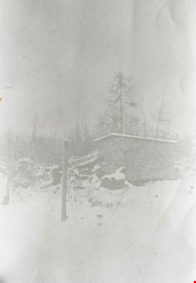
Boberg family home
https://search.heritageburnaby.ca/link/archivedescription35771
- Repository
- City of Burnaby Archives
- Date
- 1922 (date of original), copied 1986
- Collection/Fonds
- Burnaby Historical Society fonds
- Description Level
- Item
- Physical Description
- 1 photograph : b&w ; 12.7 x 17.8 cm print
- Scope and Content
- Photograph of the first Boberg family home after a heavy snowfall, on Douglas Road in the Still Creek lowlands where the creek flows into Burnaby Lake. The Bobergs moved here in 1920.
- Repository
- City of Burnaby Archives
- Date
- 1922 (date of original), copied 1986
- Collection/Fonds
- Burnaby Historical Society fonds
- Subseries
- Pioneer Tales subseries
- Physical Description
- 1 photograph : b&w ; 12.7 x 17.8 cm print
- Description Level
- Item
- Record No.
- 204-629
- Access Restriction
- No restrictions
- Reproduction Restriction
- No known restrictions
- Accession Number
- BHS1988-03
- Scope and Content
- Photograph of the first Boberg family home after a heavy snowfall, on Douglas Road in the Still Creek lowlands where the creek flows into Burnaby Lake. The Bobergs moved here in 1920.
- Media Type
- Photograph
- Notes
- Title based on contents of photograph
- Historic Neighbourhood
- Burnaby Lake (Historic Neighbourhood)
- Planning Study Area
- Ardingley-Sprott Area
Images
