Narrow Results By
In the shadow by the sea : recollections of Burnaby's Barnet Village
https://search.heritageburnaby.ca/link/museumlibrary5173
- Repository
- Burnaby Village Museum
- Publication Date
- c2004
- Call Number
- 971.133 PRI Copy 2
confirm the extensive use of Burnaby's north shore
by aboriginal peoples for thousands ofyears.
Early History
The Royal Engineers and North Road
The Barnet area was first surveyed by the Royal Engineers based in New Westmin-
ster. Local aboriginal guides took Lt. G.S. Blake ofthe Royal Marines over
- Repository
- Burnaby Village Museum
- Collection
- Digital Reference Collection
- Reference Collection
- Material Type
- Book
- ISBN
- 0969282885
- Call Number
- 971.133 PRI Copy 2
- Contributor
- Wolf, Jim
- Pride, Harry, 1925-
- Place of Publication
- Burnaby, B.C.
- Publisher
- City of Burnaby
- Publication Date
- c2004
- Physical Description
- 246 p. : ill., maps, ports. ; 28 cm.
- Library Subject (LOC)
- Burnaby (B.C.)--History
- Industries--British Columbia--Burnaby--History
- Barnet Marine Park--Burnaby, B.C.
- Geographic Access
- Barnet Road
- Burrard Inlet
- Notes
- Includes bibliographical references (p. 246) and index.
- "edited by Harry Pride and Jim Wolf"
- Copy 2 of 2
Digital Books
Land of promise : Robert Burnaby's letters from colonial British Columbia, 1858-1863
https://search.heritageburnaby.ca/link/museumlibrary5465
- Repository
- Burnaby Village Museum
- Publication Date
- c2002
- Call Number
- 971.1 BUR COPY 3
by Robert Burnaby, 26 December 1858...............................82
Robert Burnaby, c. 1863.........................................................................83
Colonel Moody, c.1863............................................................................83
Royal Engineers Camp, Sapperton, c.1864
- Repository
- Burnaby Village Museum
- Collection
- Reference Collection
- Digital Reference Collection
- Material Type
- Book
- ISBN
- 0969282850
- 9780969282853
- Call Number
- 971.1 BUR COPY 3
- Place of Publication
- Burnaby, B.C.
- Publisher
- City of Burnaby
- Publication Date
- c2002
- Physical Description
- 199 p. : ill. ; 23 cm.
- Library Subject (LOC)
- Burnaby, Robert--Correspondence
- Merchants--British Columbia--Correspondence
- British Columbia--History--1849-1871
- Burnaby (B.C.)
- Biography
- Notes
- Includes bibliographical references (p. 190) and index.
- 3 copies held: copy 3.
Digital Books
military hat badge
https://search.heritageburnaby.ca/link/museumartifact79105
- Repository
- Burnaby Village Museum
- Accession Code
- X2893
- Description
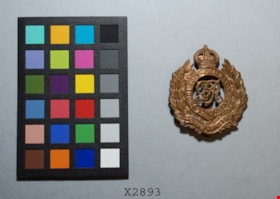
- Wreath with "Royal Engineers" in banner across the bottom. "Honi Soit Qui Mal Y Pense" around centre of the badge with a crown at top.
- Category
- 03. Personal Artifacts
- Classification
- Personal Symbols - - Personal Identification
- Object Term
- Badge, Identification
Images

pamphlet
https://search.heritageburnaby.ca/link/museumartifact90996
- Repository
- Burnaby Village Museum
- Accession Code
- BV021.11.4
- Description
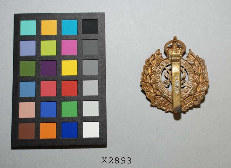
- pamphlet; white center-folded paper titled "The Centenary of the Union of the Colonies of Vancouver Island and British Columbia, November, 19, 1866" with a logo of British Columbia Confederation Centennial. In the centre there are two oval headshot photos of "Governor A. E. Kennedy, Vancouver Island" and "Governor F. Seymour, British Columbia" above a drawing of "J.A.R. Homer, High Sheriff reading Proclaimation uniting the two colonies at New Westminster, November 19, 1866." At the bottom "Issued by/ THE CANADIAN CONFEDERATION CENTENNIAL COMITTEE OF BRITISH COLUMBIA" Interior has a story of BC's history and four landscape photos of Victoria and New Westminster in 1866, and Victoria Government Offices in 1868 and Royal Engineers' camp. Back has copy of signed declaration with two seals and signatures.
- Object History
- Pamphlet was produced as part of the British Columbia Centennial '71 celebrations. It contains a story of the history of the two colonies and their joining to form Canada's sixth province on July 20, 1871. Back of the pamplet has a scan of the 1866 union proclaimation with signatures.
- Category
- 08. Communication Artifacts
- Classification
- Documentary Artifacts - - Other Documents
- Object Term
- Pamphlet
- Marks/Labels
- "LITHOGRAPHED IN CANADA BY A. SUTTON, QUEEN'S PRINTER, VICTORIA, B.C."
- Measurements
- Length: 21.5 cm x Width: 14 cm
Images


Pioneer tales of Burnaby
https://search.heritageburnaby.ca/link/museumlibrary5860
- Repository
- Burnaby Village Museum
- Collection
- Digital Reference Collection
- Reference Collection
- Material Type
- Book
- ISBN
- 096928280x
- Call Number
- 971.133 SON COPY 4
- Contributor
- Sone, Michael
- Place of Publication
- Burnaby, B.C.
- Publisher
- Corporation of the District of Burnaby
- Publication Date
- c1987
- Physical Description
- 495 p. : ill. ; 31 cm.
- Inscription
- "TR687 - Bryburgh" / handprinted in pencil on frontend page
- Library Subject (LOC)
- Pioneers--British Columbia--Burnaby
- Frontier and pioneer life
- Biography
- Object History
- Early Burnaby as recalled by the settlers themselves who arrived from every corner of the world between 1888 and 1930, some witnessing incorporation of the district in 1892, all seeking a better life for themselves and especially for their children, all helping transform the wilderness into the modern municipality of today.
- Notes
- "Editor Michael Sone".
- Includes index.
- 4 copies held: copy 4
Images

Digital Books
![Plot of Royal Engineers' Surveys - North Road, [1890] thumbnail](/media/hpo/_Data/_BVM_Cartographic_Material/2003/2003_0083_0034_002%20Web.jpg?width=280)
Plot of Royal Engineers' Surveys - North Road
https://search.heritageburnaby.ca/link/museumdescription11155
- Repository
- Burnaby Village Museum
- Date
- [1890]
- Collection/Fonds
- Ronald G. Scobbie collection
- Description Level
- Item
- Physical Description
- 1 survey plan : blueprint on paper ; 61 x 45 cm
- Scope and Content
- Survey plan of "Plot of Royal Engineers' Surveys," "North Road."
- Repository
- Burnaby Village Museum
- Collection/Fonds
- Ronald G. Scobbie collection
- Description Level
- Item
- Physical Description
- 1 survey plan : blueprint on paper ; 61 x 45 cm
- Material Details
- Scale 10 chains = 1 inch
- Scope and Content
- Survey plan of "Plot of Royal Engineers' Surveys," "North Road."
- Geographic Access
- North Road
- Accession Code
- BV003.83.34
- Access Restriction
- No restrictions
- Reproduction Restriction
- No known restrictions
- Date
- [1890]
- Media Type
- Cartographic Material
- Scan Resolution
- 440
- Scan Date
- December 2020
- Scale
- 100
- Notes
- Title based on contents of plan
- Handwritten notes on verso read: "Envelope 369", and mathematical calculat- ions
Images
![Plot of Royal Engineers' Surveys - North Road, [1890] thumbnail](/media/hpo/_Data/_BVM_Cartographic_Material/2003/2003_0083_0034_002%20Web.jpg)

Rooted : Chinese Canadian stories in Burnaby
https://search.heritageburnaby.ca/link/museumlibrary7646
- Repository
- Burnaby Village Museum
- Collection
- Digital Reference Collection
- Material Type
- Digital Resource
- ISBN
- 978-0-9689849-2-5
- Call Number
- 971.133 ROO
- Contributor
- Fong, Denise
- Lemke, Jane
- Codd, Lisa
- Place of Publication
- Burnaby
- Publisher
- City of Burnaby
- Publication Date
- 2023
- Printer
- Metropolitan Fine Printers
- Physical Description
- 203 p. : ill. ; 30.5 cm
- Library Subject (LOC)
- Chinese Canadians--British Columbia--Burnaby--History
- Race discrimination -- Canada
- Subjects
- Persons - Chinese Canadians
- Agriculture
- Agriculture - Farms
- Persons - Families
- Rights
- Rights - Human Rights
- Social Issues
- Social Issues - Racism
- Notes
- There are two versions of the book: English and Simplified Chinese (left, below) and the other in English and Traditional Chinese (right, below).
- From the late 1800s to the present day, Chinese Canadians have made Burnaby into a more vibrant and livable city. Rooted: Chinese Canadian Stories in Burnaby brings together a collection of diverse stories and photographs from the community, celebrating the legacy and contributions of Burnaby’s Chinese Canadian community spanning over a century. This coffee-table book features oral histories and interviews with descendants of multigenerational family farms, green grocers, corner stores, restaurants, and places of worship. Also included are archival research and community perspectives on anti-Asian racism, community activism, courage, and resilience.
- The publication has been timed to coincide with the 100th anniversary of the introduction of the Chinese Exclusion Act by the Government of Canada in 1923. This federal legislation followed decades of discriminatory legislation by Canada’s federal, provincial and municipal governments that targeted Chinese Canadians by limiting opportunities to live, work and raise families in Canada. The Chinese Exclusion Act banned almost all migration from China and remained in place until 1947. Publishing this book in 2023 is an effort by the City of Burnaby to recognize the impact of discriminatory legislation on Chinese Canadians in our community, including discriminatory bylaws and practices implemented by Burnaby’s early municipal government.
- Edited by Denise Fong (Lead Researcher), Jane Lemke (Burnaby Village Museum Curator) and Lisa Codd (City of Burnaby Heritage Planner).
Images

Digital Books
stereograph card
https://search.heritageburnaby.ca/link/museumartifact80013
- Repository
- Burnaby Village Museum
- Accession Code
- X3119
- Description
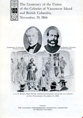
- Stereograph card produced by Underwood and Underwood Publishers. It is of a picture titled "Difficulties of the march on Pretoria - Royal Engineers making a roadway on the steep Velch/ River Banks, S.A. Copyright 1900 by Underwood & Underwood". The title is repeated on the back of the card in six different languages.
Images

![Survey and Subdivision plans in New Westminster District Group 1 and Group 2 – Vancouver, ʷməθkʷəy̓əm (Musqueam) Indian Reserve, Burnaby, Surrey
, [1910-1911] thumbnail](/media/hpo/_Data/_BVM_Cartographic_Material/1977/1977_0093_0017_001.jpg?width=280)
Survey and Subdivision plans in New Westminster District Group 1 and Group 2 – Vancouver, ʷməθkʷəy̓əm (Musqueam) Indian Reserve, Burnaby, Surrey
https://search.heritageburnaby.ca/link/museumdescription6986
- Repository
- Burnaby Village Museum
- Date
- [1910-1911]
- Collection/Fonds
- Burnaby Village Museum Map collection
- Description Level
- File
- Physical Description
- 9 plans : 4 plans : blueprint ink on paper + 4 plans : black ink on paper + 1 plan : graphite on paper mounted on 2 sides of cardboard 76 x 102 cm
- Scope and Content
- File consists of a large board of three survey plans in New Westminster District Group 1 mounted on one side and six survey and subdivision plans of District Lot 85, New Westminster District Group 1 mounted on the other side. Side A: 1. Plan : blueprint on paper ; 30.5 x 80 cm. Title reads: "Fras…
- Repository
- Burnaby Village Museum
- Collection/Fonds
- Burnaby Village Museum Map collection
- Description Level
- File
- Physical Description
- 9 plans : 4 plans : blueprint ink on paper + 4 plans : black ink on paper + 1 plan : graphite on paper mounted on 2 sides of cardboard 76 x 102 cm
- Material Details
- Scales vary (One chain equals 792 inches)
- Indexed number on tape on edge of board reads "17"
- Scope and Content
- File consists of a large board of three survey plans in New Westminster District Group 1 mounted on one side and six survey and subdivision plans of District Lot 85, New Westminster District Group 1 mounted on the other side. Side A: 1. Plan : blueprint on paper ; 30.5 x 80 cm. Title reads: "Fraser River Bridge / Plan of South Approach". Plan covers area of land north of the Fraser River and Great Northern Railway with approach for a bridge running through the "ʷməθkʷəy̓əm (Musqueam) Indian Reserve" (ʷməθkʷəy̓əm (Musqueam) First Nation) and lots marked as Dominion Government and the east half of Lot 2 identified as "C. F. Brown" "Plan 851". Plan is identified as "Plan 851 / traced / Mar. 17, 1911". (Geographic location in Vancouver) Scale: 100 feet = 1 inch, Signed by Albert J. Hill / P.L.S." 2. Plan : blueprint on paper ; 36.5 x 35 cm (no title). Includes three plans of lots on the east and west sides of North Road. Note on bottom of blueprint reads: "I.E.B. McKay Surveyor General - hereby certify / that this is a correct tracing from the field / notes of the Royal Engineers on file in the / Lands Department / E.B. McKay (signature) / Surveyor General / Victoria B.C. April 11th 1911" . Plan in top left titled "Page 11 / Vol. 1. / R.E. Notes" covers District Lots east of North Road including Lot 5, Lot 7, Lot 41, Lot 9 and Lot 107 in Coquitlam. Plan in top right corner titled "Page 17 / Vol. 1. / R.E. Notes" covers District Lots east of North Road including Lot 104, Lot 54, Lot 105, Lot 55, Lot 106, Lot 9 and Lot 107 in Coquitlam and Port Moody. Plan in lower left corner titled "Page 15 / Vol. 1 / R.E. Notes" covers District Lots west of North Road including Lot 147, Lot 148, Lot 100, Lot 15 in Burnaby. 3. Plan : blue print on paper ; 29.5 x 41.5 cm. (no formal title). Plan of the North 1/2 of Section 18. Plan covers area in the "North 1/2 of Sec.18 B.5 N RGE 1 W" and "Sec. 18 B.5 N. RGE 1 W" bordered by Section 7, Section 13, Section 17 and Section 19. Bon Accord Road runs through Sec. 18. The plan is signed by surveryor "I.H. Neville Smith... C.E.B.C.L.S. / Mar. 26th 1910" and signed by "Ludwig Pillath". (Geographic location: Surrey) Side B: 1. Plan : blueprint on paper ; 43.5 x 49.5 cm. Title reads: "Plan / of Subdivision / of a Portion / of / Lot 85 / Group One / New Westminster District. Plan covers portion of land east of Deer Lake and Pole Line Road (Sperling Avenue) and south of Hastings Road in District Lot 85 in Burnaby with section 4 and a portion of section 2 coloured in red. Plan is signed by "Albert J. Hill, B.C.L.S." Plan is initialed by: "RB" [sic] (in blue pencil crayon) Scale: 4 chains = 1 inch 2. Plaln : black black ink on linen ; 39 x 37 cm. Title reads: "L.C. Hill's Property, / Burnaby". Plan covers a triangular portion of land east of Pole Line Road (Sperling Avenue) and south of Hastings Road in District Lot 85 in Burnaby. Plan is intitaled by "RB" [sic] (in blue pencil crayon). Scale: 3 chains = 1 mile 3. Plan : graphite on paper ; 23 x 17 cm. Title reads: "Portion of Lot 85 / Gr.1". Plan covers portion of land north east of Deer Lake and west of Pole Line Road (now Sperling Avenue) in District Lot 85 in Burnaby. Plan is stamped in red ink: "Albert J. Hill, Civil Engineer". Plan is initialed by: "RB" [sic] (in blue pencil crayon). Scale: 1 chain = 1 inch 4. Plan : black ink on linen ; 16 x 19 cm. Title reads: "Lot 85". Plan covers the intersection of Pole Line Road (Sperling Avenue) and Hastings Road at the north west section of District Lot 79 and District Lot 85 in Burnaby. Plan is stamped: "A.J. Hill, Civil Engineer" with identitifed in blue pencil crayon. 5. Plan : black ink on paper ; 28.5 x 37 cm. (no formal title) Plan covers an area of land, west of Pole Line Road (Sperling Avenue) and south of Deer Lake in District Lot 85 in Burnaby. Plan is initialed by: "RB" [sic] (in blue pencil crayon) 6. Plan : black ink on paper ; 21 x 34 cm (no formal title). Plan covers an area of land, west of Pole Line Road (Sperling Avenue) and south of Deer Lake in District Lot 85 in Burnaby. Plan is initialed by: "RB" [sic] (in blue pencil crayon)
- Accession Code
- HV977.93.17
- Access Restriction
- No restrictions
- Reproduction Restriction
- No known restrictions
- Date
- [1910-1911]
- Media Type
- Cartographic Material
- Historic Neighbourhood
- Burnaby Lake (Historic Neighbourhood)
- Burquitlam (Historic Neighbourhood)
- Planning Study Area
- Morley-Buckingham Area
- Douglas-Gilpin Area
- Scan Resolution
- 600
- Scan Date
- 2023-06-26
- Notes
- Title based on contents of file
- Scale is measured in chains and feet. (One chain equals 792 inches).
- The term "Lot" also refers to a "District Lot”
- Some plans are stamped: "Albert J. Hill, Civil Engineer / and / Provincial Land Surveyor, / New Westminster, / B.C." and intialed: "RB" [sic]
Zoomable Images
![Survey and Subdivision plans in New Westminster District Group 1 and Group 2 – Vancouver, ʷməθkʷəy̓əm (Musqueam) Indian Reserve, Burnaby, Surrey
, [1910-1911] thumbnail](/media/hpo/_Data/_BVM_Cartographic_Material/1977/1977_0093_0017_003_seadragon/1977_0093_0017_003.jpg?w=280)
Survey and Subdivision plans in New Westminster District Group 1 and Group 2 – Vancouver, ʷməθkʷəy̓əm (Musqueam) Indian Reserve, Burnaby, Surrey , [1910-1911]
Zoom into Image

Tram memories : in celebration of the restoration of Interurban 1223
https://search.heritageburnaby.ca/link/museumlibrary5863
- Repository
- Burnaby Village Museum
- Author
- McGeachie, Pixie, 1921-
- Publication Date
- c2007
- Call Number
- 388.460971 TRA
- Repository
- Burnaby Village Museum
- Collection
- Digital Reference Collection
- Reference Collection
- Material Type
- Book
- Call Number
- 388.460971 TRA
- Author
- McGeachie, Pixie, 1921-
- Contributor
- Friends of Interurban 1223
- Place of Publication
- Burnaby
- Publisher
- City of Burnaby
- Publication Date
- c2007
- Printer
- City of Burnaby Printshop
- Physical Description
- 91 p. : ill., map ;,20 cm
- Library Subject (LOC)
- Electric railroads
- Local transit
- Street-railroads
- Transportation
- Geographic Access
- Vancouver
- Name Access
- British Columbia Electric Railway Company
- Notes
- Editor : Pixie McGeachie
Images

Digital Books
![Gilley Brothers Logging team, [1895]. . thumbnail](/media/hpo/_Data/_Archives_Images/_Unrestricted/371/461-003.jpg?width=280)
Vancouver Road (Kingsway)
https://search.heritageburnaby.ca/link/landmark729
- Repository
- Burnaby Heritage Planning
- Associated Dates
- 1860
- Heritage Value
- The street we know as Kingsway is one of the legacies of the Royal Engineers' military defences for New Westminster. The fear of an American attack prompted the construction of the False Creek trail - later known as Vancouver Road and now Kingsway - in 1860 to connect the capital city to the ice-free salt water harbour at English Bay.
- Historic Neighbourhood
- Central Park (Historic Neighbourhood)
- Edmonds (Historic Neighbourhood)
- Planning Study Area
- Maywood Area
- Marlborough Area
- Windsor Area
- Kingsway-Beresford Area
- Stride Avenue Area
- Edmonds Area
Images
![Gilley Brothers Logging team, [1895]. . thumbnail](/media/hpo/_Data/_Archives_Images/_Unrestricted/371/461-003.jpg)