Narrow Results By
Subject
- Advertising Medium 2
- Advertising Medium - Flyer 1
- Advertising Medium - Signs and Signboards 1
- Agricultural Tools and Equipment 1
- Agriculture - Farms 1
- Animals - Birds 1
- Armament 2
- Building Components 2
- Buildings 1
- Buildings - Agricultural 1
- Buildings - Agricultural - Greenhouses 1
- Buildings - Commercial 1
Person / Organization
- Bridge Studios 1
- British Columbia Electric Railway 2
- British Columbia Electric Railway Company 2
- British Columbia Mills Timber and Trading Company 1
- Brown, Donald N. "Don" 1
- Burnaby Lawn Bowling Club 1
- Burnaby Village Museum 2
- Central Park Provincial Park Board 1
- Century Park Museum Association 1
- Ceperley, Grace 2
- Ceperley, H.T. 2
- Chow, Hipman "Jimmy" 1

Dr. William & Ruth Baldwin House
https://search.heritageburnaby.ca/link/landmark534
- Repository
- Burnaby Heritage Planning
- Description
- The Dr. William & Ruth Baldwin House is a two-storey modern post-and-beam structure, located on the southern shore of Deer Lake in Burnaby's Deer Lake Park. The site is steeply sloped, and the main entrance of the house is at the top of the slope facing onto Deer Lake Drive.
- Associated Dates
- 1965
- Formal Recognition
- Community Heritage Register
- Repository
- Burnaby Heritage Planning
- Geographic Access
- Deer Lake Drive
- Associated Dates
- 1965
- Formal Recognition
- Community Heritage Register
- Enactment Type
- Council Resolution
- Enactment Date
- 26/05/2003
- Description
- The Dr. William & Ruth Baldwin House is a two-storey modern post-and-beam structure, located on the southern shore of Deer Lake in Burnaby's Deer Lake Park. The site is steeply sloped, and the main entrance of the house is at the top of the slope facing onto Deer Lake Drive.
- Heritage Value
- The Baldwin House is valued as a prime example of Burnaby’s post-Second World War modern heritage and progressive architectural style, as well as for its personal connections to internationally-acclaimed architect, Arthur Erickson. Inspired by the modern domestic idiom established earlier in the twentieth century by Frank Lloyd Wright and Richard Neutra, Erickson conceived his architecture as responding directly to the site. A cohesive expression of simple orthogonal lines and ultimate transparency, this structure reduces the idea of post-and-beam West Coast modernism to its most refined elements. A fine example of the evolving talent of Erickson’s earlier work, this house is a landmark modern house in Burnaby and is unique in terms of siting and context. Having just won the 1963 competition for the new Simon Fraser University in Burnaby with his partner, Geoff Massey, and having built fewer than half a dozen homes previously, Erickson’s reputation was growing and his skill as a designer of modern buildings was in great demand. The same year that Erickson/Massey Architects designed SFU, Dr. William Baldwin and his wife, Ruth, personal friends of Erickson, commissioned him to design this house. Erickson was already familiar with the site; as a child he had spent time at this spot when his family visited friends who lived on Deer Lake. Both the Baldwin House and the university were completed in 1965. SFU became internationally famous; the Baldwin House was also considered an architectural success and was recognized in publications of the time. Only a single storey of this two-storey house is visible from the road, as it is built into the hillside in response to its steep site and proximity to Deer Lake. Like many other Erickson designs, this structure was conceived as a pavilion. Constructed of glass and wood, its transparency facilitates visual access to the lake’s edge, acting as an invitation, rather than a barrier, to the landscape. The house blends into the natural surroundings and the site includes other man-made landscape features such as a reflecting pool. As a reaction to the often grey quality of light in the region, Erickson exploits flat planes of water as a source of borrowed light. The refined and purposeful design, transparency, openness of plan and adjacency to the lake combine to give the house a floating appearance at the water's edge. The concept of a floating house set within an accompanying garden was inspired, in part, by the palaces and house boats of Dal Lake in Kashmir and the famed nearby Mughal Gardens. Although Erickson never visited Dal Lake, he travelled extensively throughout India, and specifically mentions the Kashmir reference in relation to this house. There is a rich complexity of other allusions worked into the fabric of the house, unified by a feeling for the conjunction of light, water and land at this special location. Widely renowned as Canada’s most brilliant modern architect, Erickson’s reputation is important to the development and growth of modern architecture in Canada and North America.
- Defining Elements
- The elements of the Baldwin House that define its character are those materials and details which respond to the location of the building and determine the relation between landscape and building, combining to create a single cohesive site. These include its: - close proximity to water - orthogonal plan and massing, with flat tar-and-gravel roof - stepped down massing orienting the house towards the water - post-and-beam construction, with the width of the beams matched to the width of the posts - wood and glass used as primary building materials - transparency and light achieved by the abundant use of glass - large undivided sheets of single glazing - butt glazed glass corners - abundant and generous balconies, which blur the transition from interior to exterior - horizontal flush cedar siding - use of salvaged brick for chimneys - use of chains as downspouts - built-in rooftop barbeque - built in furniture and fittings dating to the time of construction, such as original hardware, benches, bathroom vanities and kitchen cabinets - landscaped site including reflecting pool, plantings and a dock protruding into the lake
- Locality
- Deer Lake Park
- Historic Neighbourhood
- Burnaby Lake (Historic Neighbourhood)
- Planning Study Area
- Morley-Buckingham Area
- Function
- Primary Current--Single Dwelling
- Primary Historic--Single Dwelling
- Community
- Burnaby
- Cadastral Identifier
- P.I.D. No. 011-946-032 and P.I.D. No. 011-946-067
- Boundaries
- The Baldwin House is comprised of two municipally-owned lots located at 6543 and 6545 Deer Lake Drive, Burnaby.
- Area
- 6,070.20
- Contributing Resource
- Building
- Landscape Feature
- Ownership
- Public (local)
- Other Collection
- Canadian Architectural Archives, University of Calgary, Collection: Original Plans No. ERI 4A/76.13
- Documentation
- Heritage Site Files: PC77000 20. City of Burnaby Planning and Building Department, 4949 Canada Way, Burnaby, B.C., V5G 1M2
- Street Address
- 6543 Deer Lake Drive
Images


Trans Mountain Pipeline Company
https://search.heritageburnaby.ca/link/landmark685
- Repository
- Burnaby Heritage Planning
- Geographic Access
- Shellmont Street
- Associated Dates
- 1953
- Heritage Value
- On March 21, 1951 the Parliament of Canada granted the Trans Mountain Oil Pipe Line Company a charter. By May of the following year, the Corporation of Burnaby gave final reading to Bylaw No. 3203, which resulted in the conveyance of land in DL 142, 143 and 144 (Burnaby Mountain site) to the Trans Mountain Oil Pipe Line Company. Construction of the Burnaby Mountain tank farm was completed in October of 1953 and the site became operational as the first shipment of oil reached Trans Mountain’s Burnaby Terminal.
- Planning Study Area
- Lake City Area
- Street Address
- 8099 Shellmont Street
- Street View URL
- Google Maps Street View
Images


Barnet Mountain Park Dedication
https://search.heritageburnaby.ca/link/landmark686
- Repository
- Burnaby Heritage Planning
- Associated Dates
- 1942
- Heritage Value
- For years, the idea of creating a park on Burnaby Mountain was favoured by people in Burnaby. In 1930, the Municipal Engineer submitted a report recommending that the city acquire land in the area with a view towards formally dedicating the space for public use. In 1942, Commissioner Richard Bolton enacted Bylaw 1772 which officially dedicated the mountain as public park.
- Historic Neighbourhood
- Barnet (Historic Neighbourhood)
- Planning Study Area
- Burnaby Mountain Area
Images


Ford Motor Company
https://search.heritageburnaby.ca/link/landmark698
- Repository
- Burnaby Heritage Planning
- Geographic Access
- Kingsway
- Associated Dates
- 1938
- Heritage Value
- In 1938, the Ford Motor Company selected Burnaby as its site for a new assembly plant to serve Western Canada. Ford purchased the land which had been owned by the Silver family at Kingsway and Silver Avenue and built its factory using steel from Burnaby's Dominion Bridge Company. During World War II, the plant was used to produce military vehicles. In 1988, the building was demolished and the Station Square development was constructed on the site.
- Historic Neighbourhood
- Central Park (Historic Neighbourhood)
- Planning Study Area
- Maywood Area
- Street Address
- 4600 Kingsway
Images


Chapel Of Peace
https://search.heritageburnaby.ca/link/landmark566
- Repository
- Burnaby Heritage Planning
- Description
- Church building.
- Associated Dates
- 1936
- Formal Recognition
- Heritage Designation, Community Heritage Register
- Other Names
- First United Spiritualist Church
- Street View URL
- Google Maps Street View
- Repository
- Burnaby Heritage Planning
- Other Names
- First United Spiritualist Church
- Geographic Access
- Kincaid Street
- Associated Dates
- 1936
- Formal Recognition
- Heritage Designation, Community Heritage Register
- Enactment Type
- Bylaw No. 13162
- Enactment Date
- 28/01/2013
- Description
- Church building.
- Heritage Value
- This church was built in 1936 as the Chapel of Peace for the Forest Lawn Cemetery. It was located outside the main entrance of the cemetery at the triangular parcel of land bounded by Sprott, Royal Oak and Canada Way. It served as the location for many memorial services, local community worship and weddings. The Anglican Church purchased and relocated the building to its present site in 1955. The church has been altered with the addition of wings and stucco, but retains its steep front gabled roof and some of its arched windows. It is now used as the First United Spiritualist Church.
- Locality
- Burnaby Lake
- Historic Neighbourhood
- Burnaby Lake (Historic Neighbourhood)
- Planning Study Area
- Douglas-Gilpin Area
- Contributing Resource
- Building
- Ownership
- Private
- Street Address
- 5584 Kincaid Street
- Street View URL
- Google Maps Street View
Images


booklet
https://search.heritageburnaby.ca/link/museumartifact19156
- Repository
- Burnaby Village Museum
- Accession Code
- HV977.17.5
- Description
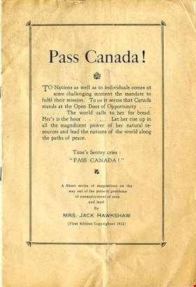
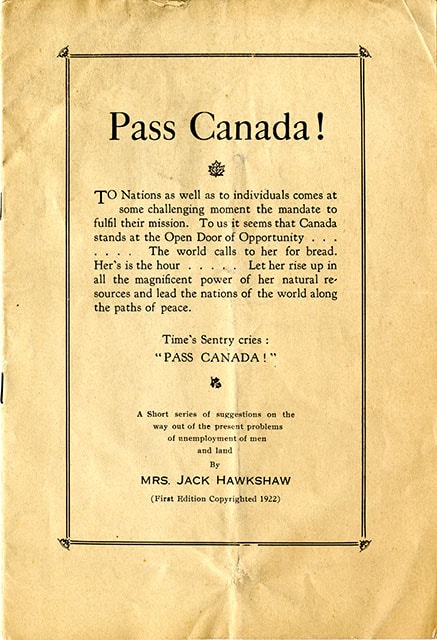
- "Pass Canada!"; bifold binding with three staples; 12 pages; second edition 1929. "Cover reads: "Pass Canada! / TO Nations as well as to individuals comes at / some challenging moment the mandate to / fulfil their mission. To us it seems that Canada / stands at the Open Door of Opportunity.../ ....The world calls to her for bread. ? Her's is the hour ...Let her rise up in / all the magnificent power of her natural re- /sources and lead the nations of the world along the paths of peace / Time's Sentry cries : "PASS CANADA! / A Short series of suggestions on the / way out of the present problems / of unemployment of men / and land / By Mrs. Jack Hawkshaw (First Edition Copyrighted 1922)".
- Object History
- From the collection of Mabel Edith Honor (McClean) Hawkshaw author and publisher of the "Burnaby Post" (1922-1937). She wrote articles for city dailies under the pen name of Percy Egerton Sterling.
- Category
- 08. Communication Artifacts
- Classification
- Documentary Artifacts - - Literary Works
- Object Term
- Serial
- Country Made
- Canada
- Province Made
- British Columbia
- Title
- Pass Canada!
- Publication Date
- 1929
Images
Documents

Confederation Park
https://search.heritageburnaby.ca/link/landmark672
- Repository
- Burnaby Heritage Planning
- Geographic Access
- Willingdon Avenue
- Associated Dates
- 1927
- Heritage Value
- North Burnaby’s first park began its life as the Capitol Hill subdivision during the land boom of 1909. In 1914 the boom went bust and many owners of unoccupied lots failed to pay the property taxes owing and the land became the property of the Municipality of Burnaby. By 1922, Burnaby had so many lots that it decided to reserve land for future park use and dedicated a narrow 26 acre site adjacent to the ravine. During the 1920s, the Heights area boomed again and many new residents wanted a playground for their children. A local women’s group took on the cause and enlisted local residents and businesses to raise the necessary funds. On June 25, 1927 crowds gathered to officially dedicate “Confederation Park” named in honour of the Diamond Jubilee of Canada’s Confederation (1867-1927).
- Historic Neighbourhood
- Capitol Hill (Historic Neighbourhood)
- Planning Study Area
- Capitol Hill Area
- Street Address
- 250 Willingdon Avenue
- Street View URL
- Google Maps Street View
Images


Kask Brothers
https://search.heritageburnaby.ca/link/landmark684
- Repository
- Burnaby Heritage Planning
- Geographic Access
- Barnet Road
- Associated Dates
- 1925
- Heritage Value
- In 1925, William Kask Sr. and his family purchased land along the Barnet Road and built what became known as Kask's Camp, where cabins were rented out to families working at the Barnet Mill. The family - William Kask Jr., Dave and Jack - went on to expand their business into a lumber and concrete supply company and in 1936, the company was named the Kask Brothers Building Supply Company. A lumber office was established on Curtis Street and the concrete plant was built at the former site of the cabin camp. To a large degree, the camp catered to Immigrants from Nordic countries who were active in the lumber trade. Many Finns felt at home in the camp, as the Kasks spoke Finnish and there were steam baths available.
- Historic Neighbourhood
- Lochdale (Historic Neighbourhood)
- Planning Study Area
- Westridge Area
- Street Address
- 7501 Barnet Road
Images


tax notice
https://search.heritageburnaby.ca/link/museumartifact80119
- Repository
- Burnaby Village Museum
- Accession Code
- BV008.19.19
- Description
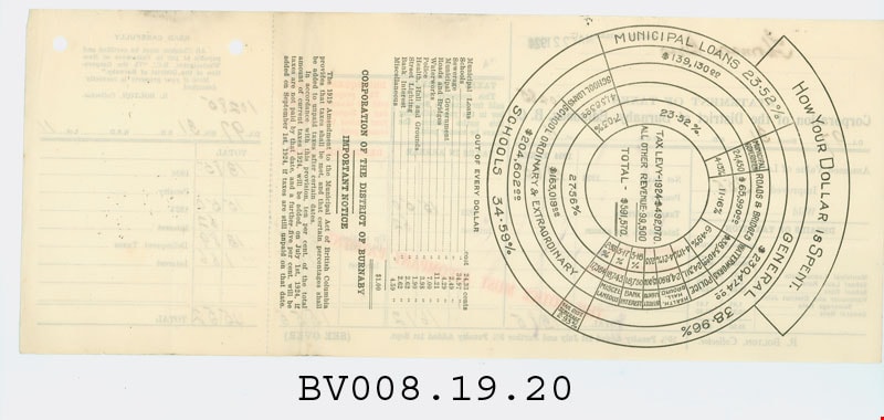
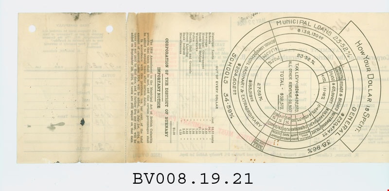
- tax assesment notice; cream paper, black, green and red print; "STATEMENT OF TAXES" "Corporation of the District of Burnaby, Edmonds, B.C."; mailed "May 22, 1924" to "Thomson Bros." "916 Yorkshire" [?] "Bdg." "Vancouver B.C."; shows taxes owing on DL 97, Block 31, Lot 10 in their Highlands properties; pre-printed form mailed to property owners, shows current taxes owed, taxes in arrears and delinquent taxes; 13.25" long x 5.5" high; tear-off portion one end to accompany payment; "R. BOLTON, Collector"; red "THIS NOTICE MUST ACCOMPANY PAYMENT"; on reverse, round chart "HOW YOUR DOLLAR IS SPENT."; two holes punched at top of tear-off; this statement is for improved land, assessed at $355, net taxes $13.84, tax from 1923 owing $15.50, interest .62, from 1922, $13.89, interest $1.66, totalling $45.51
- Object History
- The Highland Park sub-division in District Lot 97, was in part a real estate development by the company owned by the Thomson family. James and Melville P. Thomson, owned and operated "Thomson Bros." They had extensive property interests in Vancouver and Burnaby and owned and operated a book selling and stationery business in Vancouver.
- Marks/Labels
- "NOTICE MAILED MAY 22 1924 / Thomson Bros / 916 Yorkshire Bdg. / Vancouver B.C. / STATEMENT OF TAXES / Corporation of the District of Buranby, Edmonds, B.C. / D.L. 97 Block 31 S.D.____ R.S.D. ____ Lot 10 / 10284" printed with hand written details.
- Colour
- Cream
- Country Made
- Canada
- Province Made
- British Columbia
- Site/City Made
- Burnaby
- Title
- Statement of Taxes
- Publication Date
- May 22 1924
Images


tax notice
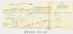
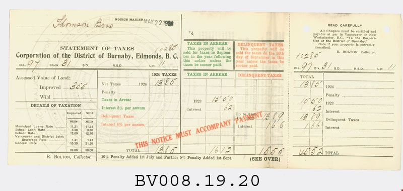
https://search.heritageburnaby.ca/link/museumartifact80120
- Repository
- Burnaby Village Museum
- Accession Code
- BV008.19.20
- Description
- tax assesment notice; cream paper, black, green and red print; "STATEMENT OF TAXES" "Corporation of the District of Burnaby, Edmonds, B.C."; mailed "May 22, 1924" to "Thomson Bros."; shows taxes owing on DL 97, Block 31, Lot 11 in their Highlands properties; pre-printed form mailed to property owners, shows current taxes owed, taxes in arrears and delinquent taxes; 13.25" long x 5.5" high; tear-off portion one end to accompany payment; "R. BOLTON, Collector"; red "THIS NOTICE MUST ACCOMPANY PAYMENT"; on reverse, round chart "HOW YOUR DOLLAR IS SPENT."; two holes punched at top of tear-off; this statement is for improved land, assessed at $355, net taxes $13.85, tax from 1923 owing $15.50, interest .62, from 1922, $13.89, interest $1.66, totalling $45.52
- Object History
- The Highland Park sub-division in District Lot 97, was in part a real estate development by the company owned by the Thomson family. James and Melville P. Thomson, owned and operated "Thomson Bros." They had extensive property interests in Vancouver and Burnaby and owned and operated a book selling and stationery business in Vancouver.
- Marks/Labels
- "NOTICE MAILED MAY 22 1924 / Thomson Bros / STATEMENT OF TAXES / Corporation of the District of Buranby, Edmonds, B.C. / D.L. 97 Block 31 S.D.____ R.S.D. ____ Lot 10 / 10285" printed with hand written details.
- Colour
- Cream
- Country Made
- Canada
- Province Made
- British Columbia
- Site/City Made
- Burnaby
- Title
- Statement of Taxes
- Publication Date
- May 22 1924
Images
tax notice
https://search.heritageburnaby.ca/link/museumartifact80121
- Repository
- Burnaby Village Museum
- Accession Code
- BV008.19.21
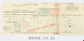
- Description
- tax assesment notice; cream paper, black, green and red print; "STATEMENT OF TAXES" "Corporation of the District of Burnaby, Edmonds, B.C."; mailed "May 22, 1924" to "Thomson Bros."; shows taxes owing on DL 97, Block 33, Lot 1 in their Highlands properties; pre-printed form mailed to property owners, shows current taxes owed, taxes in arrears and delinquent taxes; 13.25" long x 5.5" high; tear-off portion one end to accompany payment; "R. BOLTON, Collector"; red "THIS NOTICE MUST ACCOMPANY PAYMENT"; on reverse, round chart "HOW YOUR DOLLAR IS SPENT."; two holes punched at top of tear-off; this statement is for improved land, assessed at $400, net taxes $15.60 tax from 1923 owing $17.48, interest .70, from 1922, $15.64, interest $1.83, totalling $51.25
- Object History
- The Highland Park sub-division in District Lot 97, was in part a real estate development by the company owned by the Thomson family. James and Melville P. Thomson, owned and operated "Thomson Bros." They had extensive property interests in Vancouver and Burnaby and owned and operated a book selling and stationery business in Vancouver.
- Marks/Labels
- "NOTICE MAILED MAY 22 1924 / Thomson Bros / STATEMENT OF TAXES / Corporation of the District of Buranby, Edmonds, B.C. / D.L. 97 Block 33 S.D.____ R.S.D. ____ Lot 1 / 10317" printed with hand written details.
- Colour
- Cream
- Country Made
- Canada
- Province Made
- British Columbia
- Site/City Made
- Burnaby
- Title
- Statement of Taxes
- Publication Date
- May 22 1924
Images

tax notice
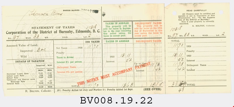
https://search.heritageburnaby.ca/link/museumartifact80122
- Repository
- Burnaby Village Museum
- Accession Code
- BV008.19.22
- Description
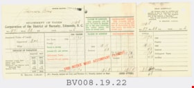
- tax assesment notice; cream paper, black, green and red print; "STATEMENT OF TAXES" "Corporation of the District of Burnaby, Edmonds, B.C."; mailed "May 22, 1924" to "Thomson Bros."; shows taxes owing on DL 97, Block 33, Lot 2 in their Highlands properties; pre-printed form mailed to property owners, shows current taxes owed, taxes in arrears and delinquent taxes; 13.25" long x 5.5" high; tear-off portion one end to accompany payment; "R. BOLTON, Collector"; red "THIS NOTICE MUST ACCOMPANY PAYMENT"; on reverse, round chart "HOW YOUR DOLLAR IS SPENT."; two holes punched at top of tear-off; this statement is for improved land, assessed at $300, net taxes $11.70, tax from 1923 owing $13.11, interest .52, from 1922, $11.73, interest $1.42, totalling $38.48
- Object History
- The Highland Park sub-division in District Lot 97, was in part a real estate development by the company owned by the Thomson family. James and Melville P. Thomson, owned and operated "Thomson Bros." They had extensive property interests in Vancouver and Burnaby and owned and operated a book selling and stationery business in Vancouver.
- Marks/Labels
- "NOTICE MAILED MAY 22 1924 / Thomson Bros / STATEMENT OF TAXES / Corporation of the District of Buranby, Edmonds, B.C. / D.L. 97 Block 33 S.D.____ R.S.D. ____ Lot 2 / 10318" printed with hand written details.
- Colour
- Cream
- Country Made
- Canada
- Province Made
- British Columbia
- Site/City Made
- Burnaby
- Title
- Statement of Taxes
- Publication Date
- May 22 1924
Images

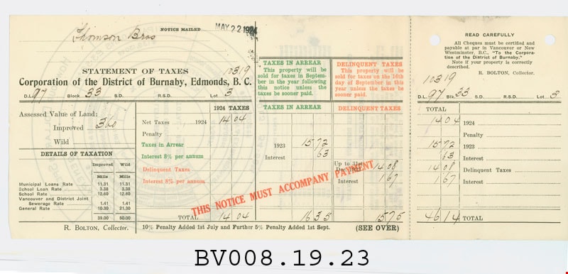
tax notice
https://search.heritageburnaby.ca/link/museumartifact80123
- Repository
- Burnaby Village Museum
- Accession Code
- BV008.19.23
- Description
- tax assesment notice; cream paper, black, green and red print; "STATEMENT OF TAXES" "Corporation of the District of Burnaby, Edmonds, B.C."; mailed "May 22, 1924" to "Thomson Bros."; shows taxes owing on DL 97, Block 33, Lot 3 in their Highlands properties; pre-printed form mailed to property owners, shows current taxes owed, taxes in arrears and delinquent taxes; 13.25" long x 5.5" high; tear-off portion one end to accompany payment; "R. BOLTON, Collector"; red "THIS NOTICE MUST ACCOMPANY PAYMENT"; on reverse, round chart "HOW YOUR DOLLAR IS SPENT."; two holes punched at top of tear-off; this statement is for improved land, assessed at $360, net taxes $14.04, tax from 1923 owing $15.72, interest .63, from 1922, $14.08, interest $1.67, totalling $46.14
- Object History
- The Highland Park sub-division in District Lot 97, was in part a real estate development by the company owned by the Thomson family. James and Melville P. Thomson, owned and operated "Thomson Bros." They had extensive property interests in Vancouver and Burnaby and owned and operated a book selling and stationery business in Vancouver.
- Marks/Labels
- "NOTICE MAILED MAY 22 1924 / Thomson Bros / STATEMENT OF TAXES / Corporation of the District of Buranby, Edmonds, B.C. / D.L. 97 Block 33 S.D.____ R.S.D. ____ Lot 3 / 10319" printed with hand written details.
- Colour
- Cream
- Country Made
- Canada
- Province Made
- British Columbia
- Site/City Made
- Burnaby
- Title
- Statement of Taxes
- Publication Date
- May 22 1924
Images

tax notice
https://search.heritageburnaby.ca/link/museumartifact80124
- Repository
- Burnaby Village Museum
- Accession Code
- BV008.19.24
- Description
- tax assesment notice; cream paper, black, green and red print; "STATEMENT OF TAXES" "Corporation of the District of Burnaby, Edmonds, B.C."; mailed "May 22, 1924" to "Thomson Bros."; shows taxes owing on DL 97, Block 33, Lot 7 in their Highlands properties; pre-printed form mailed to property owners, shows current taxes owed, taxes in arrears and delinquent taxes; 13.25" long x 5.5" high; tear-off portion one end to accompany payment; "R. BOLTON, Collector"; red "THIS NOTICE MUST ACCOMPANY PAYMENT"; on reverse, round chart "HOW YOUR DOLLAR IS SPENT."; two holes punched at top of tear-off; this statement is for improved land, assessed at $290, net taxes $11.31, tax from 1923 owing $12.67, interest .50, from 1922, $11.32, interest $1.36, totalling $37.16
- Object History
- The Highland Park sub-division in District Lot 97, was in part a real estate development by the company owned by the Thomson family. James and Melville P. Thomson, owned and operated "Thomson Bros." They had extensive property interests in Vancouver and Burnaby and owned and operated a book selling and stationery business in Vancouver.
- Marks/Labels
- "NOTICE MAILED MAY 22 1924 / Thomson Bros / STATEMENT OF TAXES / Corporation of the District of Buranby, Edmonds, B.C. / D.L. 97 Block 33 S.D.____ R.S.D. ____ Lot 7 / 10323" printed with hand written details.
- Colour
- Cream
- Country Made
- Canada
- Province Made
- British Columbia
- Site/City Made
- Burnaby
- Title
- Statement of Taxes
- Publication Date
- May 22 1924
Images


tax notice
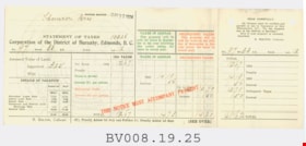
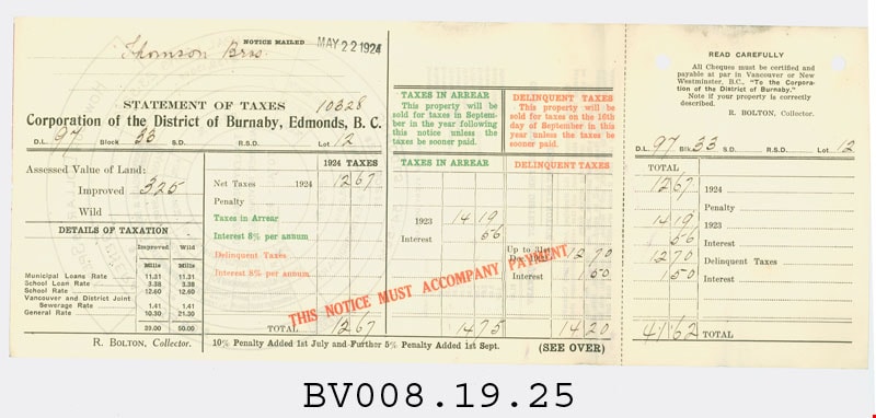
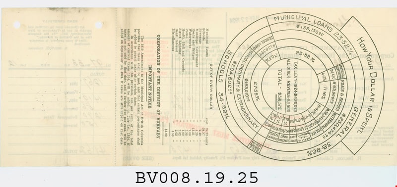
https://search.heritageburnaby.ca/link/museumartifact80125
- Repository
- Burnaby Village Museum
- Accession Code
- BV008.19.25
- Description
- tax assesment notice; cream paper, black, green and red print; "STATEMENT OF TAXES" "Corporation of the District of Burnaby, Edmonds, B.C."; mailed "May 22, 1924" to "Thomson Bros."; shows taxes owing on DL 97, Block 33, Lot 12 in their Highlands properties; pre-printed form mailed to property owners, shows current taxes owed, taxes in arrears and delinquent taxes; 13.25" long x 5.5" high; tear-off portion one end to accompany payment; "R. BOLTON, Collector"; red "THIS NOTICE MUST ACCOMPANY PAYMENT"; on reverse, round chart "HOW YOUR DOLLAR IS SPENT."; two holes punched at top of tear-off; this statement is for improved land, assessed at $325, net taxes $12.67, tax from 1923 owing $14.19, interest .56, from 1922, $12.70, interest $1.50, totalling $41.62
- Object History
- The Highland Park sub-division in District Lot 97, was in part a real estate development by the company owned by the Thomson family. James and Melville P. Thomson, owned and operated "Thomson Bros." They had extensive property interests in Vancouver and Burnaby and owned and operated a book selling and stationery business in Vancouver.
- Marks/Labels
- "NOTICE MAILED MAY 22 1924 / Thomson Bros / STATEMENT OF TAXES / Corporation of the District of Buranby, Edmonds, B.C. / D.L. 97 Block 33 S.D.____ R.S.D. ____ Lot 12 / 10328" printed with hand written details.
- Colour
- Cream
- Country Made
- Canada
- Province Made
- British Columbia
- Site/City Made
- Burnaby
- Title
- Statement of Taxes
- Publication Date
- May 22 1924
Images
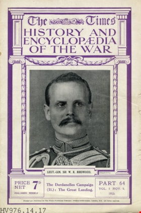
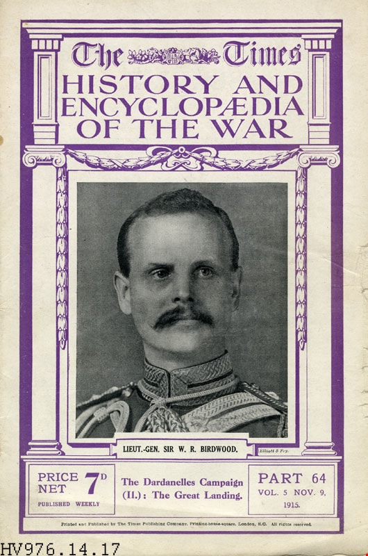
magazine
https://search.heritageburnaby.ca/link/museumartifact20866
- Repository
- Burnaby Village Museum
- Accession Code
- HV976.14.17
- Description
- The Times - Magazine -- [1915]. The Times History and Encyclopaedia of the War. The magazine was printed weekly and gave updates on the status of the Great War or World War I. This issue is Part 64, Vol 5, November 9, 1915 This edition highlights the Dardanelles Campaign and The Great Landing. The magazine is printed and published by The Times Publishing Company.
- Maker
- Times Publishing Company
- Country Made
- England
- Site/City Made
- London
- Title
- The Times History and Encyclopaedia of the War
- Publication Date
- 1915
Images

Central Park Entrance Gate
https://search.heritageburnaby.ca/link/landmark544
- Repository
- Burnaby Heritage Planning
- Description
- The Central Park Entrance Gate is the ceremonial entrance to Burnaby’s historic Central Park from Kingsway, and consists of two massive stone pillars, approximately 7.5 metres high and 1.8 metres square, adjacent gate posts and a low flanking stone wall that curves into the park to the east.
- Associated Dates
- 1913
- Formal Recognition
- Heritage Designation, Community Heritage Register
- Street View URL
- Google Maps Street View
- Repository
- Burnaby Heritage Planning
- Geographic Access
- Imperial Street
- Associated Dates
- 1913
- Formal Recognition
- Heritage Designation, Community Heritage Register
- Enactment Type
- Bylaw No. 9807
- Enactment Date
- 23/11/1992
- Description
- The Central Park Entrance Gate is the ceremonial entrance to Burnaby’s historic Central Park from Kingsway, and consists of two massive stone pillars, approximately 7.5 metres high and 1.8 metres square, adjacent gate posts and a low flanking stone wall that curves into the park to the east.
- Heritage Value
- The Central Park Entrance Gate is significant as a ceremonial entry to a major park, for its connection with the early history of the British Columbia Electric Railway (BCER) and as an important design by an accomplished British Columbian architect. When the original interurban line between Vancouver and New Westminster was constructed in 1891, one of the first stations was located where the tramway crossed the Vancouver-Westminster Road (now Kingsway) within the newly-created Central Park. The interurban line ran through the park on a diagonal right-of-way (the current SkyTrain line, opened in 1986, follows this original alignment). In 1912 an agreement was reached between the successor interurban company, the BCER, and the Central Park Provincial Park Board, to deed additional land for an expanded right-of-way through the Park in exchange for improvements that included the construction of an ornamental stone wall and gate with an iron arch, with an illuminated 'Central Park' sign, adjacent to the interurban station on Kingsway. This was an early and rare example of an electric sign used for a public recreation facility. The Gate is also significant as a surviving early design by Robert Lyon (1879-1963), an Edinburgh-born and trained immigrant who was one of the most accomplished of British Columbia's early architects. After he moved to Vancouver, he was employed by the BCER from 1911 until 1918, and worked on a broad range of projects including some of the grandest and most innovative local industrial structures of the time. The arch was built by the Westminster Ironworks Company, one of the leading firms of its kind in Western Canada, operated by John Reid of New Westminster. The Gate was completed in 1914; in 1968 the decorative ironwork was removed due to corrosion and placed in storage.
- Defining Elements
- Key elements that define the heritage character of the Central Park Entrance Gate include its: - two subtly tapered massive stone pillars, which rise in stages from a larger base to a shaft with random coursed multi-coloured granite with roughly formed grey granite quoins, to a top formed of finely finished grey granite blocks with a coved and bracketed cap - adjacent gate posts with monolithic pyramidal granite caps - low flanking stone wall that curves into the park to the east, constructed of random coursed multi-coloured granite with a river rock triangular cap
- Historic Neighbourhood
- Central Park (Historic Neighbourhood)
- Planning Study Area
- Maywood Area
- Architect
- Robert Lyon
- Builder
- John Reid
- Westminster Iron Works Co.
- Function
- Primary Current--Park Fixture
- Primary Historic--Park Fixture
- Community
- Burnaby
- Cadastral Identifier
- P.I.D. No. 017-767-172 Legal Description: Block B of Lot 2 Except Firstly: Part on Plan 8669 and Secondly: Part on Plan LMP4689 District Lot 151, Group 1, New Westminster District, Plan 3443
- Boundaries
- The property (Central Park) is a municipally-owned park that lies at the western edge of Burnaby, between 49th Avenue to the south, Kingsway to the north, Boundary Road to the west and Patterson Avenue to the east.
- Area
- 853,403.82
- Contributing Resource
- Structure
- Landscape Feature
- Ownership
- Public (local)
- Names
- Lyon, Robert
- Reid, John
- Westminster Iron Works Company
- British Columbia Electric Railway Company
- Central Park Provincial Park Board
- Subjects
- Structures - Fences
- Street Address
- 3883 Imperial Street
- Street View URL
- Google Maps Street View
Images


T.O. Townley Estate 'Deerholme'
https://search.heritageburnaby.ca/link/landmark545
- Repository
- Burnaby Heritage Planning
- Description
- The T.O. Townley Estate, 'Deerholme,' is located on a lake front property on the north shore of Deer Lake Park. The main house is a two-and-one-half storey symmetrical-massed wood-frame Colonial Revival structure, with flanking one-storey wings, a side gable roof and a central front entry.
- Associated Dates
- 1913
- Formal Recognition
- Heritage Designation, Community Heritage Register
- Other Names
- Thomas & Frances Townley Estate, Loftus House
- Street View URL
- Google Maps Street View
- Repository
- Burnaby Heritage Planning
- Other Names
- Thomas & Frances Townley Estate, Loftus House
- Geographic Access
- Price Street
- Associated Dates
- 1913
- Formal Recognition
- Heritage Designation, Community Heritage Register
- Enactment Type
- Bylaw No. 9807
- Enactment Date
- 23/11/1992
- Description
- The T.O. Townley Estate, 'Deerholme,' is located on a lake front property on the north shore of Deer Lake Park. The main house is a two-and-one-half storey symmetrical-massed wood-frame Colonial Revival structure, with flanking one-storey wings, a side gable roof and a central front entry.
- Heritage Value
- 'Deerholme' was built as the retirement estate of Lieutenant-Colonel Thomas Owen Townley (1862-1935) and his wife, Frances M. Townley. Townley was a pioneer resident of the Lower Mainland of British Columbia: he served as a lawyer, Registrar of Land Titles for New Westminster District and Mayor of Vancouver for one term in 1901. Built in 1913, this is one of the most significant of the Deer Lake estate houses and was the last of grand Edwardian era mansions built on the lots surrounding the lake. The area had been opened up for development two years earlier by the construction of the British Columbia Electric Railway Interurban Line. The estate speaks of a gracious way of life achieved by society's elite during the Edwardian era, supported by the use of domestic servants. Grand in scale, architecturally sophisticated and set in a bucolic landscape, this residence demonstrates the social status of the owner in the privileged classes of the rapidly developing social structure of Burnaby. The house is also significant as one of the earliest designs by the son of Thomas and Frances Townley, architect Fred Laughton Townley (1887-1966), who had graduated in architecture in 1911 from the University of Pennsylvania. In this house for his parents, he demonstrated his deft understanding of the American Period Revival styles learned during his schooling in the United States. The prevailing local taste for British-derived architecture dictated that this was a style he was rarely able to use until the Colonial Revival styles became more popular in the 1920s. F.L. Townley was a founding partner in Townley and Matheson, which achieved significant success as one of the most accomplished local architectural firms, culminating in their best-known commission, Vancouver City Hall, 1935-36.
- Defining Elements
- Key elements the define the heritage character of ‘Deerholme’ include its: - integration with its south-sloping lakefront site, which contains many original landscape features (extant rockeries, formal drive, tennis lawn, open fields, and specimen shrubs and trees) - two-and-one-half storey form with flanking one-storey wings - side gable roof with symmetrical shed dormers, three at the front and three at the rear - complex fenestration, including multi-paned wooden-sash double-hung windows, 6-over-1 on the ground floor and 6-over-9 on the second floor, and multi-paned wooden-sash casements in the dormers - pair of prominent exterior brick chimneys on each side elevation, clad with rough-cast stucco up to the roof level, and each with four chimney-pots - rough-cast stucco cladding - design elements typical of the Colonial Revival style, such as composed classical formality, side gable roof and balanced symmetrical massing - exterior architectural elements, such as classical columns, window shutters, fanlight feature window, multi-paned quarter-round windows flanking the chimneys, and projecting square brackets in the gables - superior level of design and craftsmanship throughout, including refined interior woodwork such as fireplaces, interior columned screen between hallway and living room and a staircase with Colonial Revival details - significant mature trees (such as Red Oaks, Silver Maples, and Copper Beech). - original guest house and stables, which survive on an adjacent property at 6176 Price Street
- Historic Neighbourhood
- Burnaby Lake (Historic Neighbourhood)
- Planning Study Area
- Douglas-Gilpin Area
- Architect
- Fred Laughton Townley
- Function
- Primary Current--Estate
- Primary Historic--Estate
- Community
- Burnaby
- Cadastral Identifier
- P.I.D. No. 002-652-111 Legal Description: Parcel 'C' (Explanatory Plan 12891) , Blocks 4 and 5, District Lot 79 Group 1, New Westminster District, Plan 536
- Boundaries
- ‘Deerholme’ is comprised of a single municipally-owned property located at 6110 Price Street, Burnaby.
- Area
- 14,099.52
- Contributing Resource
- Building
- Landscape Feature
- Ownership
- Public (local)
- Other Collection
- City of Vancouver Archives: T.O. Townley Residence, Original Plans, Add. MSS. 1399, Temporary No. 61, Location 920-D
- Documentation
- Heritage Site Files: PC77000 20. City of Burnaby Planning and Building Department, 4949 Canada Way, Burnaby, B.C., V5G 1M2
- Street Address
- 6110 Price Street
- Street View URL
- Google Maps Street View
Images


H.D. Morrison House
https://search.heritageburnaby.ca/link/landmark521
- Repository
- Burnaby Heritage Planning
- Description
- The H.D. Morrison House is a tall, two and one-half storey plus basement wood-frame Edwardian era residence, with an eclectic combination of Arts and Crafts stylistic elements. It is now located adjacent to a large multi-family residential building in the Vancouver Heights neighbourhood of North Bu…
- Associated Dates
- 1912
- Formal Recognition
- Heritage Designation, Community Heritage Register
- Other Names
- Harrison D. Morrison House
- Street View URL
- Google Maps Street View
- Repository
- Burnaby Heritage Planning
- Other Names
- Harrison D. Morrison House
- Geographic Access
- Albert Street
- Associated Dates
- 1912
- Formal Recognition
- Heritage Designation, Community Heritage Register
- Enactment Type
- Bylaw No. 10626
- Enactment Date
- 22/09/1997
- Description
- The H.D. Morrison House is a tall, two and one-half storey plus basement wood-frame Edwardian era residence, with an eclectic combination of Arts and Crafts stylistic elements. It is now located adjacent to a large multi-family residential building in the Vancouver Heights neighbourhood of North Burnaby.
- Heritage Value
- The H.D. Morrison House is valued for its association with the initial speculative development phase of the Vancouver Heights neighbourhood, initiated during the Edwardian era as a high-class residential subdivision. Building contractor Harrison D. Morrison built this house as a rental property in 1912, at the height of the land speculation boom prior to the First World War. Buyers in the neighbourhood were obligated by the developer, G.F. and J. Galt Limited, to build houses worth a minimum of $3,500 at a time when the average house price was $1,000. Additionally, the H.D. Morrison House is a typical example of builders' houses of the time period, distinguished by the unique stacked balconies on the front facade. It was one of the surviving landmark residences built between 1909 and 1914 during the first development boom in Vancouver Heights.
- Defining Elements
- Key elements that define the heritage character of the H.D. Morrison House include its: - location on a south-facing slope in the Vancouver Heights neighbourhood of North Burnaby - residential form, scale and massing as exemplified by its symmetrical two and one-half storey plus basement height, front gabled roof and rectangular plan - vernacular Arts and Crafts style elements such as the exposed roof beams and rafter tails, decorative scalloped shingles in the front gable and decorative brackets - main floor full open front verandah on the front facade with two stacked balconies above, all detailed with square columns, scroll-cut brackets and overhanging roof eaves - bowed balustrade on main floor verandah - boxed eaves with scroll-cut brackets - recessed top floor gable treatment - cladding, including lapped wooden siding at the main floor and cedar shingles on the second floor and in the gable ends, with decorative diamond-cut shingles in the front gable end - front entry door with incised design, dentil detail and rectangular glass inset, with glassed sidelights - irregular fenestration: double-hung 1-over-1 wooden-sash windows; and three part casement window on main floor front facade, with diamond-shaped leaded lights in double transom above - corbelled red brick internal chimney
- Historic Neighbourhood
- Vancouver Heights (Historic Neighbourhood)
- Planning Study Area
- Burnaby Heights Area
- Function
- Primary Historic--Single Dwelling
- Primary Current--Multiple Dwelling
- Community
- Burnaby
- Cadastral Identifier
- 003-318-371
- Boundaries
- The H.D. Morrison House is comprised of a single residential lot located at 3765 Albert Street, Burnaby.
- Area
- 2263
- Contributing Resource
- Building
- Ownership
- Private
- Street Address
- 3765 Albert Street
- Street View URL
- Google Maps Street View
Images


F.J. Hart Estate 'Avalon'
https://search.heritageburnaby.ca/link/landmark542
- Repository
- Burnaby Heritage Planning
- Description
- The F.J. Hart Estate, 'Avalon,' is comprised of 5.26 hectares of lakefront property now located within Deer Lake Park, an Arts and Crafts/Tudor Revival styled mansion and an associated later outbuilding. The mansion is now operated as the Hart House Restaurant.
- Associated Dates
- 1912
- Formal Recognition
- Heritage Designation, Community Heritage Register
- Other Names
- Hart House, Rosedale Gardens, Frederick John & Alice Hart Estate
- Street View URL
- Google Maps Street View
- Repository
- Burnaby Heritage Planning
- Other Names
- Hart House, Rosedale Gardens, Frederick John & Alice Hart Estate
- Geographic Access
- Deer Lake Avenue
- Associated Dates
- 1912
- Formal Recognition
- Heritage Designation, Community Heritage Register
- Enactment Type
- Bylaw No. 9807
- Enactment Date
- 23/11/1992
- Description
- The F.J. Hart Estate, 'Avalon,' is comprised of 5.26 hectares of lakefront property now located within Deer Lake Park, an Arts and Crafts/Tudor Revival styled mansion and an associated later outbuilding. The mansion is now operated as the Hart House Restaurant.
- Heritage Value
- 'Avalon' and its estate grounds are important as an illustration of the cultural, aesthetic, and lifestyle values of the wealthy families that settled in the Deer Lake area early in the twentieth century. These values were predominantly those of elegant country living and leisure pursuits. The estate is important for its connection with wealthy land developer Frederick John Hart (1868-1945), who was not only instrumental in the creation of subdivisions which promoted Deer Lake as an exclusive residential development for successful families in the New Westminster and Vancouver area, but was also an influential member of this new suburban community and of the emerging municipality of Burnaby. Hart had a wide range of business, civic, and political interests: his real-estate company managed many of the land sales in the area and numerous other large developments throughout the region; he was an entrepreneurial businessman associated with a number of companies important to the economic development of the area and British Columbia; and he was a 'public spirited citizen' and an alderman for the City of New Westminster. The architectural style of ‘Avalon’ set the tone for many of the grand mansions in the adjacent residential development - British Arts and Crafts in derivation, with eclectic details, particularly Tudor precedents. Designed for Hart and his wife Alice Chapman Hart (1867-1935) by Burnaby architect Frank William Macey (1863-1935), the use of references to Tudor England illustrates the relevance and importance to the residents of the area of a strong and visible connection with Britain. The first resident architect in Burnaby, Macey was born and trained in England where he was well-respected for having published two standard texts for the architectural profession. He settled in Burnaby in the first decade of the twentieth century and obtained a number of commissions from prominent businessmen who were building grand homes in the new community of Deer Lake. He designed mostly in the British Arts and Crafts style and introduced the use of rough-cast stucco for building exteriors, a characteristic for which he was renowned, and of which ‘Avalon’ is an excellent example.
- Defining Elements
- Key elements that define the heritage character of 'Avalon' include its: - estate in its entirety: house, grounds, landscape features and garage outbuilding - complex asymmetrical massing - side gable roof punctuated with massive cross gables at the front and rear and open gable ends - exterior features of the house such as the rough-cast stucco with mock-Tudor timbering; cobble-stone facings; square tower with mock battlements - multiple-assemblies of wooden-sash casement windows - tall, prominent corbelled brick chimneys - grand interior spaces and fittings: particularly the entrance hall with its carved stone fireplace; the main staircase; panelled wainscotting; Tudor-arched windows; and fireplaces with original tile surrounds
- Locality
- Deer Lake Park
- Historic Neighbourhood
- Burnaby Lake (Historic Neighbourhood)
- Planning Study Area
- Morley-Buckingham Area
- Architect
- Frank William Macey
- Function
- Primary Current--Eating or Drinking Establishment
- Primary Historic--Estate
- Community
- Burnaby
- Cadastral Identifier
- P.I.D. No. 002-764-431 Legal Description: Lot 6 Except: Firstly: Part on Reference Plan 14874 and Secondly: Part subdivided by Plan 77594, District Lot 85, Group 1, New Westminster District, Plan 11109
- Boundaries
- 'Avalon' is comprised of a single municipally-owned property located at 6664 Deer Lake Avenue, Burnaby.
- Area
- 18,792.29
- Contributing Resource
- Building
- Landscape Feature
- Ownership
- Public (local)
- Other Collection
- Burnaby Village Museum, Collection: Hart Photograph Albums
- Documentation
- Heritage Site Files: PC77000 20. City of Burnaby Planning and Building Department, 4949 Canada Way, Burnaby, B.C., V5G 1M2
- Street Address
- 6664 Deer Lake Avenue
- Street View URL
- Google Maps Street View
Images

