Narrow Results By
Person / Organization
- British Columbia Electric Railway 1
- British Columbia Electric Railway Company 1
- Burnaby Centennial '71 Committee 5
- Burnaby Monumental Works 1
- Burnaby Village Museum 5
- Central Park Provincial Park Board 1
- City of Burnaby 1
- Copan, Donald Angus "Don" 1
- Dairyland 1
- Feedham, Phoebe Leonard Love 1
- Fraser Valley Milk Producers Association 1
- Girl Guides of Canada 4
Parachute Jumps and Fireworks for the Pre and Post-Game Ceremonies at the Vancouver Whitecaps Season Opener on 2003 May 03
https://search.heritageburnaby.ca/link/councilreport2527
- Repository
- City of Burnaby Archives
- Report ID
- 64628
- Meeting Date
- 28-Apr-2003
- Format
- Council - Manager's Report
- Manager's Report No.
- 12
- Item No.
- 11
- Collection/Fonds
- City Council and Office of the City Clerk fonds
- Repository
- City of Burnaby Archives
- Report ID
- 64628
- Meeting Date
- 28-Apr-2003
- Format
- Council - Manager's Report
- Manager's Report No.
- 12
- Item No.
- 11
- Collection/Fonds
- City Council and Office of the City Clerk fonds
Documents

Jubilee Grove Arch
https://search.heritageburnaby.ca/link/landmark533
- Repository
- Burnaby Heritage Planning
- Description
- The Jubilee Grove Arch sits at the corner of Kingsway and Patterson Avenue. Located within Central Park, the ceremonial arch and its decorative plantings provide a visual anchor to the northeast corner and entry point to the park.
- Associated Dates
- 1939
- Formal Recognition
- Heritage Designation, Community Heritage Register
- Street View URL
- Google Maps Street View
- Repository
- Burnaby Heritage Planning
- Geographic Access
- Imperial Street
- Associated Dates
- 1939
- Formal Recognition
- Heritage Designation, Community Heritage Register
- Enactment Type
- Bylaw No. 9807
- Enactment Date
- 23/11/1992
- Description
- The Jubilee Grove Arch sits at the corner of Kingsway and Patterson Avenue. Located within Central Park, the ceremonial arch and its decorative plantings provide a visual anchor to the northeast corner and entry point to the park.
- Heritage Value
- Jubilee Grove Arch was dedicated as part of the municipality’s celebration of the Jubilee of the coronation of King George V and was dedicated during Burnaby’s annual May Day celebrations in 1935. Much of the construction work was carried out by local citizens under the direction of the Burnaby Engineering Department through a Depression era work relief program that provided a way for local residents to pay their taxes. The garden was also chosen as the site for the ceremonial planting of an oak tree from the Royal Forest at Windsor, in honor of the Coronation of King George VI and Queen Elizabeth in 1937. The original bronze garden dedication plaque and oak tree remain at the site today. The decorative stone arch was erected in 1939 as a symbol of Burnaby's, and the Lower Mainland of British Columbia’s, strong ties to the English monarchy at the time, and the arch’s unveiling during May Day ceremonies shows the social role that such a commemorative feature played both to the local government and people of Burnaby. It was erected just prior to the Royal Visit of 1939, the first time that reigning British monarchs had travelled to Canada. Built of Haddington Island sandstone, the arch itself was reconstructed from a salvaged architectural element of a historic Vancouver landmark. The arch originally framed the entrance door to the Vancouver Club building in Vancouver, built in 1893-94 on West Hastings Street and designed by architect C.O. Wickenden. The building was demolished in 1930, however the arch was stored and rebuilt as the focal point of the Jubilee Grove after being bought by the Municipality of Burnaby. The work was undertaken by Italian-born stone mason Rizieri Stefanini (1879-1954), the owner of Burnaby Monumental Works. The re-use of the arch symbolizes the close tie between Vancouver and Burnaby and the joint evolution of the neighbouring cities.
- Defining Elements
- The Jubilee Grove Arch has character-defining elements that recognize it both as a remnant of a past building and as a new and individual structure. These include its: - axial diagonal placement and prominent corner location marking one of the entries to Central Park - visibility and accessibility as a public monument - hand carved stone blocks of Haddington Island sandstone - decorative twisted-rope motif carved to outline the arch - supporting rusticated sidewalls with planting urns - original bronze dedication plaque - flanking ornamental gardens - Royal Oak tree and plaque
- Historic Neighbourhood
- Central Park (Historic Neighbourhood)
- Planning Study Area
- Maywood Area
- Organization
- City of Burnaby
- Architect
- C.O. Wickenden
- Function
- Primary Current--Park Fixture
- Primary Historic--Park Fixture
- Community
- Burnaby
- Cadastral Identifier
- P.I.D. No. 017-767-172 Legal Description: Block B of Lot 2 Except Firstly: Part on Plan 8669 and Secondly: Part on Plan LMP4689 District Lot 151, Group 1, New Westminster District, Plan 3443
- Boundaries
- The property (Central Park) is a municipally-owned park that lies at the western edge of Burnaby, between 49th Avenue to the south, Kingsway to the north, Boundary Road to the west and Patterson Avenue to the east.
- Area
- 853,403.82
- Contributing Resource
- Structure
- Landscape Feature
- Ownership
- Public (local)
- Documentation
- Heritage Site Files: PC77000 20. City of Burnaby Planning and Building Department, 4949 Canada Way, Burnaby, B.C., V5G 1M2
- Names
- Burnaby Monumental Works
- Street Address
- 3883 Imperial Street
- Street View URL
- Google Maps Street View
Images


North Burnaby Cenotaph
https://search.heritageburnaby.ca/link/landmark550
- Repository
- Burnaby Heritage Planning
- Description
- The North Burnaby Cenotaph is located in Confederation Park at the north end of the park on axis with the adjacent sports oval. The form of the memorial is of an obelisk atop a solid rectangular base, adorned with plaques commemorating those lost in the First World War, Second World War and the Kor…
- Associated Dates
- 1953
- Formal Recognition
- Heritage Designation, Community Heritage Register
- Repository
- Burnaby Heritage Planning
- Geographic Access
- Willingdon Avenue
- Associated Dates
- 1953
- Formal Recognition
- Heritage Designation, Community Heritage Register
- Enactment Type
- Bylaw No. 9807
- Enactment Date
- 23/11/1992
- Description
- The North Burnaby Cenotaph is located in Confederation Park at the north end of the park on axis with the adjacent sports oval. The form of the memorial is of an obelisk atop a solid rectangular base, adorned with plaques commemorating those lost in the First World War, Second World War and the Korean War.
- Heritage Value
- Built in 1953 by stonemason and First World War Veteran, Walter Holmes Morrice, the cenotaph was erected by the North Burnaby Legion Post #148 and is one of four memorials to citizens of Burnaby whose lives were lost at war. Strategically placed in an active and vibrant public park that was dedicated in 1927 and is used for sports, family outings and social gatherings, the cenotaph celebrates the freedoms that soldiers gave their lives to protect. The cenotaph is still used as a memorial site and bears witness to annual Remembrance Day ceremonies. Built of irregular granite blocks, the cenotaph is a solid structure of modest ornamentation that visually anchors the north end of the park. The site of the cenotaph and its adjacent gardens are surrounded by a simple barrier of continuous chain supported by low metal fence posts, providing a sense of solemnity and ceremony to the site.
- Defining Elements
- The character-defining elements of the North Burnaby Cenotaph include its: - axial location in the park and setting among active municipal facilities such as a school and library - strong symmetry of massing and design - obelisk form set atop a rectangular base - limited palette of materials - random coursed granite used as primary building material - bronze plaques commemorating the First and Second World Wars and the Korean War - surrounding pathways and flowerbeds
- Historic Neighbourhood
- Capitol Hill (Historic Neighbourhood)
- Planning Study Area
- Capitol Hill Area
- Organization
- North Burnaby Legion Post #148
- Builder
- Walter Holmes Morrice
- Function
- Primary Current--Park Fixture
- Primary Historic--Park Fixture
- Community
- Burnaby
- Cadastral Identifier
- P.I.D. No. 017-040-752 Legal Description: Parcel 1, District Lots 122 and 188, Group 1, New Westminster District, Plan NWP87902
- Boundaries
- The property (Confederation Park) is comprised of a single municipally-owned property located at 250 Willingdon Avenue, Burnaby.
- Area
- 184,160.00
- Contributing Resource
- Landscape Feature
- Structure
- Ownership
- Public (local)
- Documentation
- Heritage Site Files: PC77000 20. City of Burnaby Planning and Building Department, 4949 Canada Way, Burnaby, B.C., V5G 1M2
- Street Address
- 250 Willingdon Avenue
Images


Central Park Entrance Gate
https://search.heritageburnaby.ca/link/landmark544
- Repository
- Burnaby Heritage Planning
- Description
- The Central Park Entrance Gate is the ceremonial entrance to Burnaby’s historic Central Park from Kingsway, and consists of two massive stone pillars, approximately 7.5 metres high and 1.8 metres square, adjacent gate posts and a low flanking stone wall that curves into the park to the east.
- Associated Dates
- 1913
- Formal Recognition
- Heritage Designation, Community Heritage Register
- Street View URL
- Google Maps Street View
- Repository
- Burnaby Heritage Planning
- Geographic Access
- Imperial Street
- Associated Dates
- 1913
- Formal Recognition
- Heritage Designation, Community Heritage Register
- Enactment Type
- Bylaw No. 9807
- Enactment Date
- 23/11/1992
- Description
- The Central Park Entrance Gate is the ceremonial entrance to Burnaby’s historic Central Park from Kingsway, and consists of two massive stone pillars, approximately 7.5 metres high and 1.8 metres square, adjacent gate posts and a low flanking stone wall that curves into the park to the east.
- Heritage Value
- The Central Park Entrance Gate is significant as a ceremonial entry to a major park, for its connection with the early history of the British Columbia Electric Railway (BCER) and as an important design by an accomplished British Columbian architect. When the original interurban line between Vancouver and New Westminster was constructed in 1891, one of the first stations was located where the tramway crossed the Vancouver-Westminster Road (now Kingsway) within the newly-created Central Park. The interurban line ran through the park on a diagonal right-of-way (the current SkyTrain line, opened in 1986, follows this original alignment). In 1912 an agreement was reached between the successor interurban company, the BCER, and the Central Park Provincial Park Board, to deed additional land for an expanded right-of-way through the Park in exchange for improvements that included the construction of an ornamental stone wall and gate with an iron arch, with an illuminated 'Central Park' sign, adjacent to the interurban station on Kingsway. This was an early and rare example of an electric sign used for a public recreation facility. The Gate is also significant as a surviving early design by Robert Lyon (1879-1963), an Edinburgh-born and trained immigrant who was one of the most accomplished of British Columbia's early architects. After he moved to Vancouver, he was employed by the BCER from 1911 until 1918, and worked on a broad range of projects including some of the grandest and most innovative local industrial structures of the time. The arch was built by the Westminster Ironworks Company, one of the leading firms of its kind in Western Canada, operated by John Reid of New Westminster. The Gate was completed in 1914; in 1968 the decorative ironwork was removed due to corrosion and placed in storage.
- Defining Elements
- Key elements that define the heritage character of the Central Park Entrance Gate include its: - two subtly tapered massive stone pillars, which rise in stages from a larger base to a shaft with random coursed multi-coloured granite with roughly formed grey granite quoins, to a top formed of finely finished grey granite blocks with a coved and bracketed cap - adjacent gate posts with monolithic pyramidal granite caps - low flanking stone wall that curves into the park to the east, constructed of random coursed multi-coloured granite with a river rock triangular cap
- Historic Neighbourhood
- Central Park (Historic Neighbourhood)
- Planning Study Area
- Maywood Area
- Architect
- Robert Lyon
- Builder
- John Reid
- Westminster Iron Works Co.
- Function
- Primary Current--Park Fixture
- Primary Historic--Park Fixture
- Community
- Burnaby
- Cadastral Identifier
- P.I.D. No. 017-767-172 Legal Description: Block B of Lot 2 Except Firstly: Part on Plan 8669 and Secondly: Part on Plan LMP4689 District Lot 151, Group 1, New Westminster District, Plan 3443
- Boundaries
- The property (Central Park) is a municipally-owned park that lies at the western edge of Burnaby, between 49th Avenue to the south, Kingsway to the north, Boundary Road to the west and Patterson Avenue to the east.
- Area
- 853,403.82
- Contributing Resource
- Structure
- Landscape Feature
- Ownership
- Public (local)
- Names
- Lyon, Robert
- Reid, John
- Westminster Iron Works Company
- British Columbia Electric Railway Company
- Central Park Provincial Park Board
- Subjects
- Structures - Fences
- Street Address
- 3883 Imperial Street
- Street View URL
- Google Maps Street View
Images


Burnaby Municipal Hall
https://search.heritageburnaby.ca/link/landmark807
- Repository
- Burnaby Heritage Planning
- Geographic Access
- Canada Way
- Associated Dates
- 1956
- Heritage Value
- When staff outgrew the municipal buildings at Edmonds and Kingsway, a debate erupted over where to build a new municipal hall. North Burnaby residents argued against the Kingsway and Edmonds site as it was too removed for their needs, but South Burnaby residents were not prepared to accept a hall in North Burnaby. The debate was finally resolved when it was suggested that the new civic centre for the municipality be in the exact geographic centre of Burnaby. Fortunately, this meant that the new hall was to be built near Deer Lake, in the beautiful Central Valley setting. Burnaby voters accepted this decision and approved the $625,000.00 it would take to build the new structure and the official opening ceremony was held June 22, 1956 when then Reeve Charles MacSorley received the keys to the hall from the contractor.
- Historic Neighbourhood
- Burnaby Lake (Historic Neighbourhood)
- Planning Study Area
- Douglas-Gilpin Area
- Street Address
- 4949 Canada Way
- Street View URL
- Google Maps Street View
Images


St. Nicholas Anglican Church
https://search.heritageburnaby.ca/link/landmark641
- Repository
- Burnaby Heritage Planning
- Description
- Church building.
- Associated Dates
- 1912
- Street View URL
- Google Maps Street View
- Repository
- Burnaby Heritage Planning
- Geographic Access
- Triumph Street
- Associated Dates
- 1912
- Description
- Church building.
- Heritage Value
- This church was one of the first built in North Burnaby to serve the new community of Vancouver Heights. Designed by architect Frank Barrs and constructed by local builders, Arthur England and Mr. Scott, it reflected the English roots of the Anglican Church with its fine Arts and Crafts style. It was officially opened in an impressive ceremony by the Bishop of New Westminster and could accommodate 200 worshippers. It was named after Saint Nicholas, the patron saint of sailors. The adjoining parish hall was completed in 1920. The church building features a gabled roof, triangular eave brackets and a semi-octagonal apse. Stucco has been applied to the exterior, but it retains its original form, scale and massing. It now houses the Burnaby Pacific Grace Church. English-born Frank Barrs (1871-1963) arrived in Vancouver in 1907 and established an office for about one year before he began working for the Vancouver Exhibition Association. He briefly established a partnership (1912-1913) with Samuel Shewbrooks (1877-1957), and was active as an architect until about 1933.
- Locality
- Vancouver Heights
- Historic Neighbourhood
- Vancouver Heights (Historic Neighbourhood)
- Planning Study Area
- Burnaby Heights Area
- Architect
- Frank A.A. Barrs
- Area
- 1695.45
- Contributing Resource
- Building
- Ownership
- Private
- Street Address
- 3883 Triumph Street
- Street View URL
- Google Maps Street View
Images


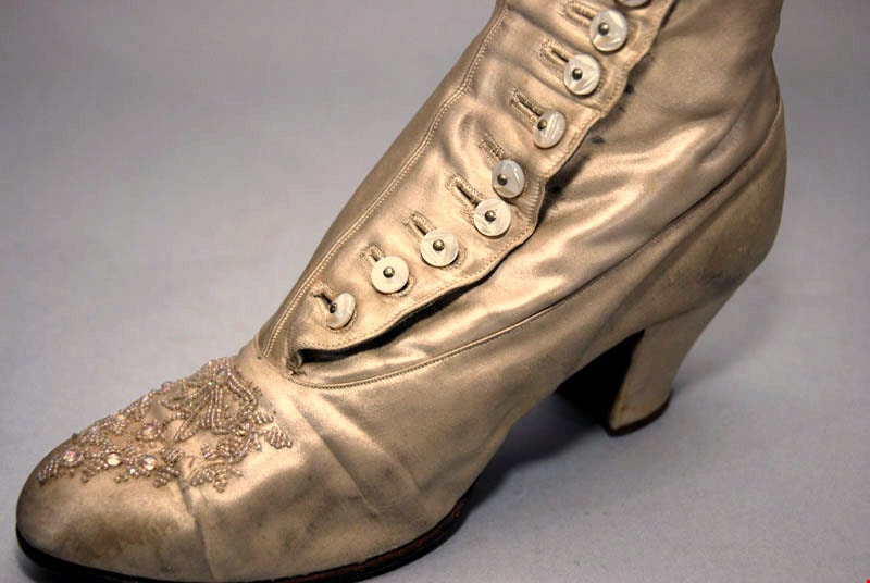
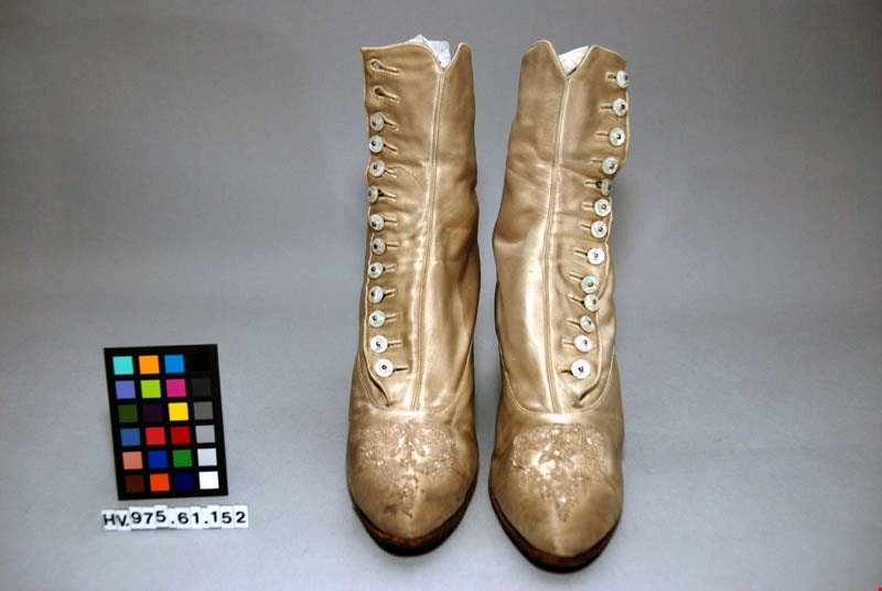
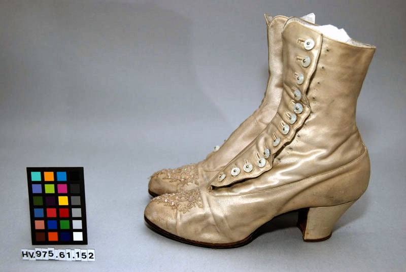
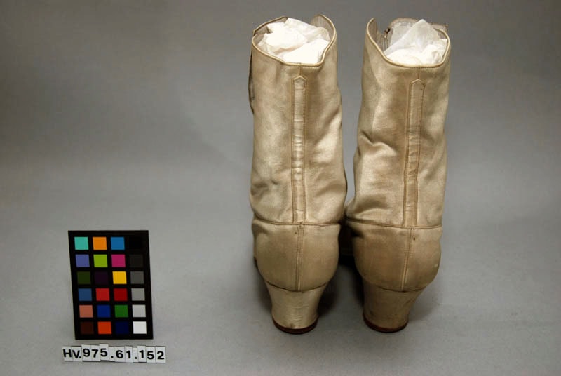
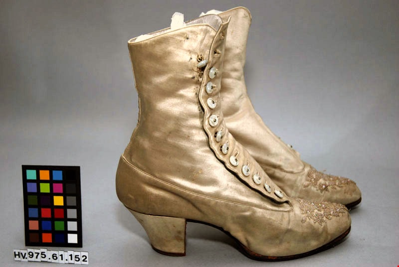
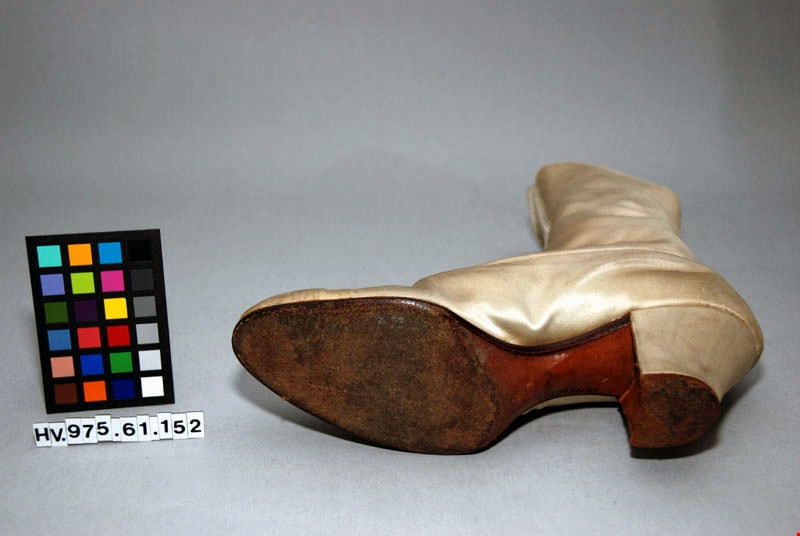
boots
https://search.heritageburnaby.ca/link/museumartifact25518
- Repository
- Burnaby Village Museum
- Accession Code
- HV975.61.152
- Description
- Pair of boots, woman's, white satin over leather, high block heel; glass bead decoration on toe in shape of bow and garland; 13 buttons
- Object History
- For wedding.
Images

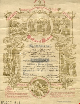
certificate
https://search.heritageburnaby.ca/link/museumartifact19110
- Repository
- Burnaby Village Museum
- Accession Code
- HV977.8.1
- Description
- Certificate of Marriage - Certificate -- [1908]. Marriage Certificate for Jón Jónsson of Vancouver BC and Lilja Einarsson of Winnipeg, MB. They were married April 29th 1908 in Winnipeg, Manitoba. The certificate has images all round the border in gold and passages from the Bible in red text. The certificate was published by Ernst Kaufmann, Lahr, Baden in New York.
- Object History
- Lilja and Jon moved to British Columbia in 1910. They eventually moved to Burnaby and lived on 464 Northcliffe Crescent in Burnaby with their son Harold. Jon worked at the Vancouver Shipyards as a foreman.
- Subjects
- Documentary Artifacts
- Documentary Artifacts - Certificates
- Ceremonies
- Ceremonies - Weddings
Images

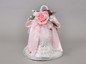
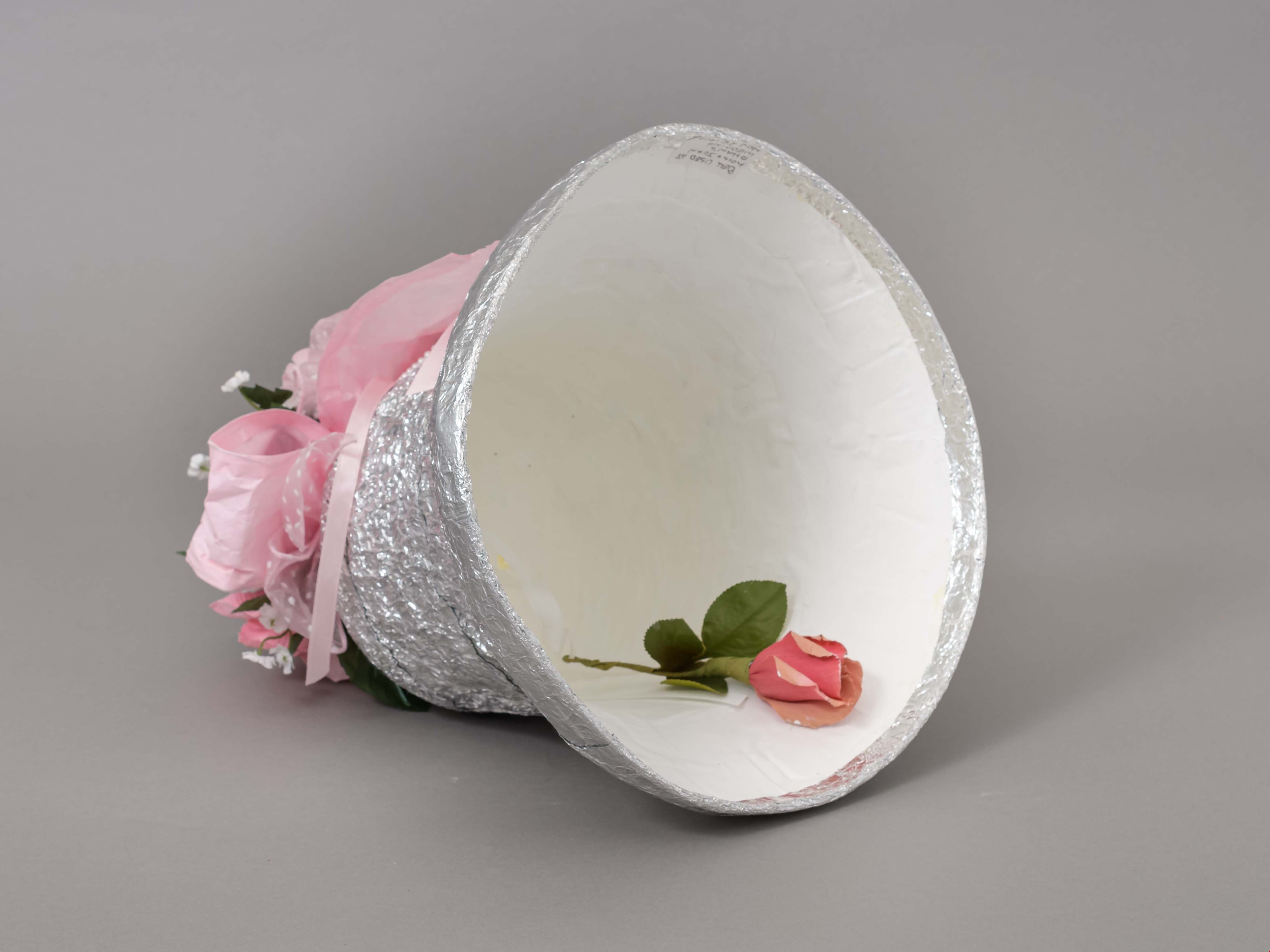
Bell
https://search.heritageburnaby.ca/link/museumartifact90700
- Repository
- Burnaby Village Museum
- Accession Code
- BV019.53.3
- Description
- Wedding bell decoration, wrapped in tin foil. The top of the bell has a hook made from white pipe cleaners. There are white and pink silk flowers and green leaves at the top of the bell.
- Object History
- This wedding bell was passed down and used a several family weddings since the 1940s.
- Category
- 02. Furnishings
- Classification
- Decorative Furnishings
- Object Term
- Decoration
- Colour
- Silver
- Pink
- Green
- White
- Subjects
- Ceremonies - Weddings
- Historic Neighbourhood
- Edmonds (Historic Neighbourhood)
- Planning Study Area
- Edmonds Area
Images


cake box
https://search.heritageburnaby.ca/link/museumartifact90989
- Repository
- Burnaby Village Museum
- Accession Code
- BV021.11.3
- Description
- Flatted light brown cardboard cake box. Top has blue triangle with British Columbia Centennial Logo in yellow with 3 'C' shapes and a white dogwood in the middle. "TO:" with 4 lines, "POSTAGE HERE" and XXXBRITISH COLUMBIA'S CENTENNIAL '71 CAKE" Side flap reads "A TINY TASTE OF THE WORLD'S LARGEST CAKE / A CENTENNIAL PROJECT SPONSORED BY THE MERCHANTS AND OWNERS OF / LOUGHEED MALL, BURNABY, B.C. CANADA." The other side flap "A SIGHT AND A TASTE TO REMEMBER" "BEAUTIFUL - RICH - DELICIOUS" "CUT ONLY WITH SHARP KNIFE - DO NOT REFRIDGERATE - KEEP IN COOL PLACE" End panel flap reads "ORIGINAL RECIPE/ WORLD'S FAMOUS "BRITISH COLUMBIA / OFFICAL/ CENTENNIAL CAKE" / 25,500 LBS. / LOUGHEED MALL / BURNABY, B.C. CANADA" and other side "GREENTINGS FROM:"
- Object History
- Cake boxes were made to share pieces of a 25,000 pound, 24-foot high offical Centennial cake cake that was displayed at Lougheed Mall. It was baked by George Molecey of Nanaimo, using his Princess Margaret 1958 cake recipe. Newspapers reported it to be the largest fruit cake ever made, and it ws decorated with a tonne of bright coloured icing. The cost of the cake was $50,000 with 15 professional baking assistants working on it for six weeks. The cake celebrated the province's 100th birthday, and the first cut was made by Chief Dan George and Burnaby Mayor, R. W. Prittle.
- Measurements
- 41cm x 35cm
- Subjects
- Ceremonies
- Ceremonial Artifacts
- Container - Box
- Events
- Events - Anniversaries
- Celebrations - Centennials
Images
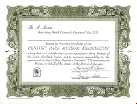
certificate
https://search.heritageburnaby.ca/link/museumartifact82058
- Repository
- Burnaby Village Museum
- Accession Code
- BV012.11.15
- Description
- Century Park Museums Association Certificate for 1971 founding members of "CENTURY PARK MUSEUM ASSOCIATION" not filled in, signed by Donald Copan (donor) and Elsie Blake. Certificate was produced by Heritage Village.
- Object History
- Created by the Century Park Museum Association, a non profit community association which governed Heritage Village (later Burnaby Village Museum) between October 1971 and December 1989. Donald "Don" Copan was the founding president of the association and continued to serve on the Century Park Museum Association (later Burnaby Village Museum Association) until 1989.
- Category
- 08. Communication Artifacts
- Classification
- Documentary Artifacts - - Other Documents
- Object Term
- Certificate
- Maker
- Heritage Village
- Country Made
- Canada
- Province Made
- British Columbia
- Site/City Made
- Burnaby
- Publication Date
- 1971
- Subjects
- Ceremonies - Awards
Images


license plate
https://search.heritageburnaby.ca/link/museumartifact90997
- Repository
- Burnaby Village Museum
- Accession Code
- BV021.11.5
- Description
- blue metal license plate with yellow logo of the British Columbia Centennial '71 with "1871/ CONFEDERATION" and "1971/ CENTENNIAL" on either side. "BRITISH COLUMBIA" at the top, and "BURNABY, B.C." at the bottom. White border with two oval mounting holes at top. Rear is gold colour.
- Object History
- Vanity license plate was produced as part of the British Columbia Centennial '71 celebrations.
- Classification
- Land Transportation T&E - - Land Transportation Accessories
- Object Term
- Plate, License
- Measurements
- 30cm wide x 10cm high
Images

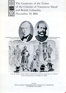
pamphlet
https://search.heritageburnaby.ca/link/museumartifact90996
- Repository
- Burnaby Village Museum
- Accession Code
- BV021.11.4
- Description
- pamphlet; white center-folded paper titled "The Centenary of the Union of the Colonies of Vancouver Island and British Columbia, November, 19, 1866" with a logo of British Columbia Confederation Centennial. In the centre there are two oval headshot photos of "Governor A. E. Kennedy, Vancouver Island" and "Governor F. Seymour, British Columbia" above a drawing of "J.A.R. Homer, High Sheriff reading Proclaimation uniting the two colonies at New Westminster, November 19, 1866." At the bottom "Issued by/ THE CANADIAN CONFEDERATION CENTENNIAL COMITTEE OF BRITISH COLUMBIA" Interior has a story of BC's history and four landscape photos of Victoria and New Westminster in 1866, and Victoria Government Offices in 1868 and Royal Engineers' camp. Back has copy of signed declaration with two seals and signatures.
- Object History
- Pamphlet was produced as part of the British Columbia Centennial '71 celebrations. It contains a story of the history of the two colonies and their joining to form Canada's sixth province on July 20, 1871. Back of the pamplet has a scan of the 1866 union proclaimation with signatures.
- Category
- 08. Communication Artifacts
- Classification
- Documentary Artifacts - - Other Documents
- Object Term
- Pamphlet
- Marks/Labels
- "LITHOGRAPHED IN CANADA BY A. SUTTON, QUEEN'S PRINTER, VICTORIA, B.C."
- Measurements
- Length: 21.5 cm x Width: 14 cm
Images

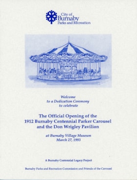
program
https://search.heritageburnaby.ca/link/museumartifact83633
- Repository
- Burnaby Village Museum
- Accession Code
- BV014.2.1
- Description
- Program for the Official Opening and Dedication of the 1912 Burnaby Centennial Parker Carousel and the Don Wrigley Pavilion, at Burnaby Village Museum, March 25, 1993. The program is printed on heavy card stock of an off-white colour. The text and images are printed in a dark blue ink. The stock is an 11 by 17 inch sheet folded in half giving four pages 8.5 by 11 inches. The front cover features an artists image of a carousel and Burnaby logos. The first inside page features "The Story of the Carousel" , History of C.W. Parker Carousel No. 119" and "The Don Wrigley Pavilion". Page two features "Dedication Ceremony" program. The back cover features, "The Friends of the Carousel", Highlights of the New Facility", "Carousel Operation", "Acknowledgements" and "Special Thanks To".
- Object History
- Program for the dedication of Parker 119 Carousel and the Don Wrigley Pavilion where the carousel is housed.
- Category
- 08. Communication Artifacts
- Classification
- Documentary Artifacts - - Other Documents
- Object Term
- Program
- Maker
- City of Burnaby
- Country Made
- Canada
- Province Made
- British Columbia
- Site/City Made
- Burnaby
- Title
- Official Opening and Dedication of the 1912 Burnaby Centennial Parker Carousel and the Don Wrigley Pavilion
- Publication Date
- 1993
- Subjects
- Ceremonies
- Documentary Artifacts
- Events
Images

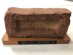
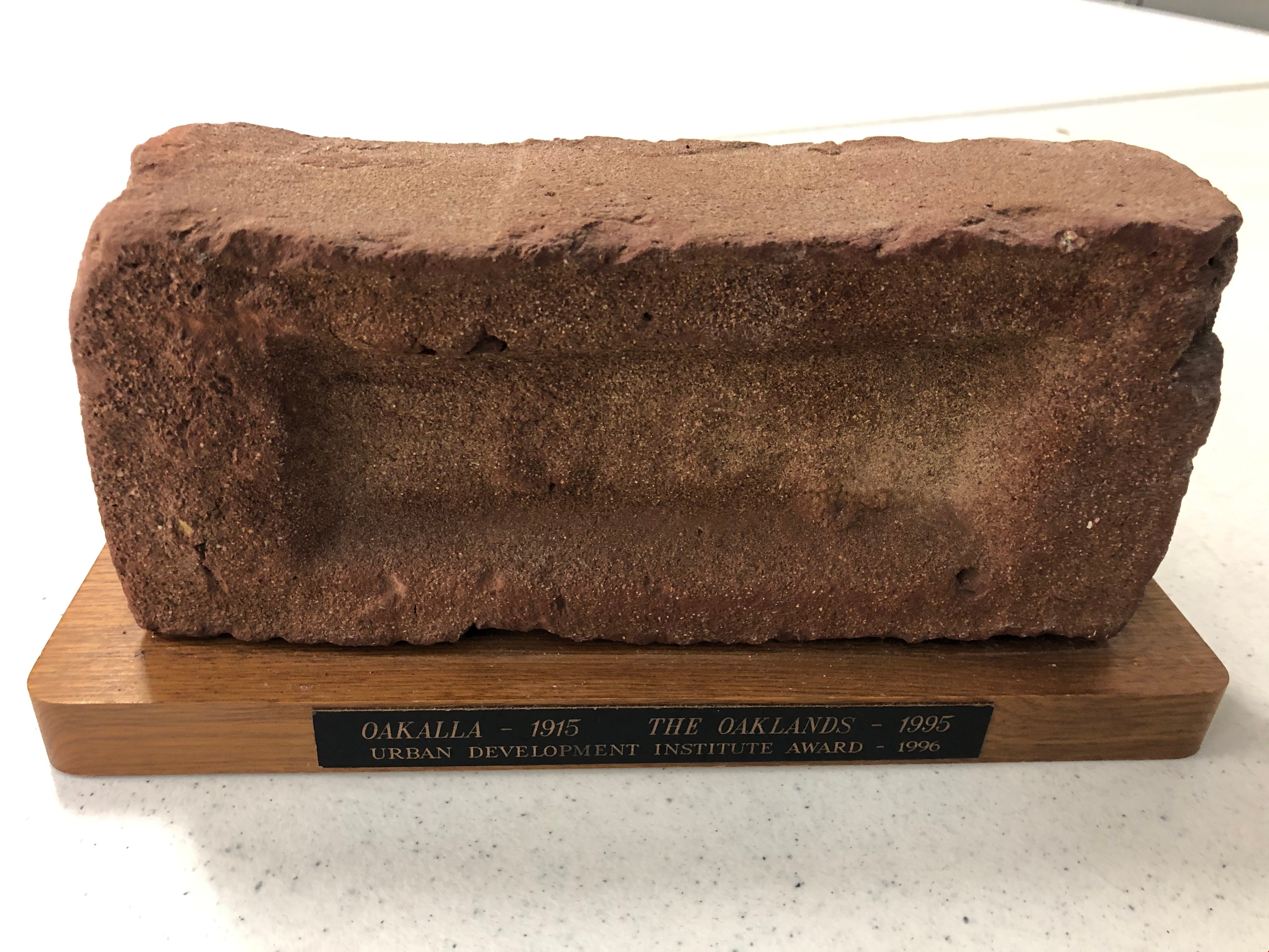
Trophy
https://search.heritageburnaby.ca/link/museumartifact90819
- Repository
- Burnaby Village Museum
- Accession Code
- BV020.40.10
- Description
- Maroon brick mounted to a brown varnished wooden stand. On one long edge of the wooden stand is a black plaque with gold letteres reads: OAKALLA 1915 / THE OAKLANDS / Urban Development Institute Award - 1996
- Object History
- This was awarded to the City of Burnaby Planning Department by the Urban Development Institute in 1996 for the redevlopment of the lands which were Oakalla Provincial Prison from 1915-1991.
- Category
- 08. Communication Artifacts
- Classification
- Personal Symbols - - Achievement Symbols
- Object Term
- Trophy
- Colour
- Maroon
- Brown
- Subjects
- Building Components
- Ceremonies - Awards
- Planning - City Planning
- Public Services - Correctional
- Names
- Oakalla Prison Farm
- Historic Neighbourhood
- Central Park (Historic Neighbourhood)
- Planning Study Area
- Oakalla Area
Images
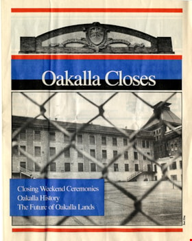
booklet
https://search.heritageburnaby.ca/link/museumartifact91099
- Repository
- Burnaby Village Museum
- Accession Code
- BV991.45.161
- Description
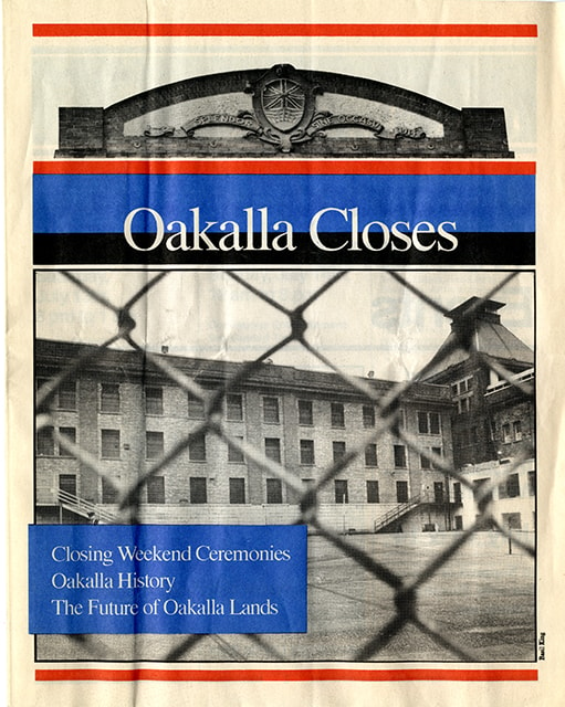
- booklet; 15 pages; single folded sheets of newsprint glued together at fold; black, blue and red ink text and photographs on front paper cover; text and photographs within in black ink; title on front cover reads: "Oakalla Closes"; text in blue text box bottom left on front cover reads: "Closing Weekend Ceremonies / Oakalla History / The Future of Oakalla Lands"; includes table of contents on page 4 with note "printed and produced for the Burnaby / Hospital Foundation's Oakalla Closing / Ceremonies. Distributed by Canada Post, / third class bulk"; photographs within credited to photographer "Basil King" and "Vancouver Public Library"; text on back cover reads "Please Recycle".
- Object History
- Salvaged from Oakalla Prison Farm site in October 1991
- Category
- 08. Communication Artifacts
- Classification
- Documentary Artifacts - - Other Documents
- Object Term
- Pamphlet
- Measurements
- L: 26.2cm W: 20.4cm H: 0.2cm
- Country Made
- Canada
- Province Made
- British Columbia
- Site/City Made
- Burnaby
- Title
- Oakalla Closes
- Publication Date
- [1991]
- Subjects
- Public Services - Correctional
Images

program
https://search.heritageburnaby.ca/link/museumartifact91463
- Repository
- Burnaby Village Museum
- Accession Code
- BV020.5.2158
- Description
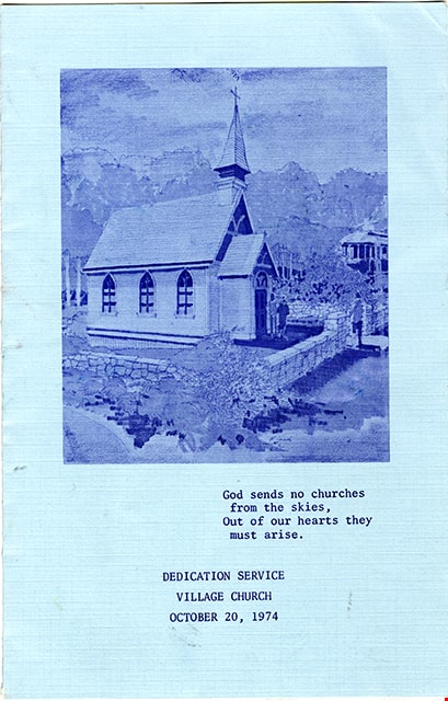
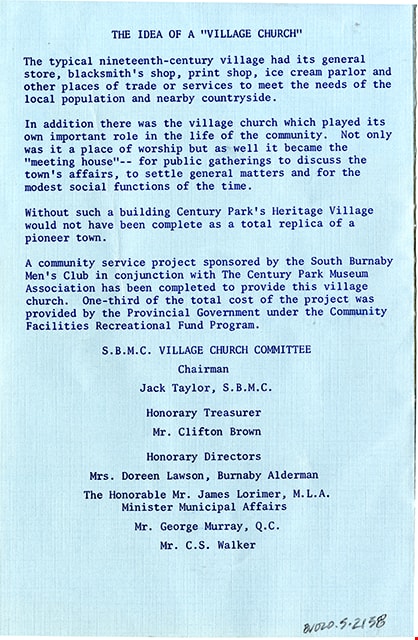
- Program; heavy weight paper folded in half; blue exterior; white interior; printed both sides in blue ink. Cover of program includes an illustration of the Heritage Village church; text below read: "God sends no churches / from the skies, / Out of our hearts they / must arise. / DEDICATION SERVICE / VILLAGE CHURCH / OCTOBER 20, 1974". Inside content on white, title at top of first page reads "Opening Ceremonies and Dedication Service / of the / HERITAGE VILLAGE CHURCH" followed by intinery, hyms "FAITH of OUR FATHERS" AND "STAND UP, STAND UP FOR JESUS" and "DECLARATION OF DEDICATION". Verso of program reads: "THE IDEA OF A "VILLAGE CHURCH" ... S.B.M.C. VILLAGE CHURCH COMMITTEE / Chairman / Jack Taylor, S.B.M.C. / Honorary Treasures / Mr. Clifton Brown / Honorary Directors / Mrs. Doreen Lawson, Burnaby Alderman / The Honorable Mr. James Lorimer, M.L.A. / Minister Municipal Affairs / Mr. George Murray, Q.C. / Mr. C.S. Walker"
- Object History
- Church service program for the opening ceremonies and dedication service of the Heritage Village Church taking place on October 20, 1974. The Heritage Village Church was built by the South Burnaby Men's Club (now South Burnaby Metro Club) in 1974.
- Category
- 08. Communication Artifacts
- Classification
- Documentary Artifacts - - Other Documents
- Object Term
- Program
- Colour
- Blue
- White
- Measurements
- Length: 28 cm x Width: 21.5 cm folded to Length: 14 cm x Width: 21.5 cm
- Maker
- Burnaby Village Museum
- Country Made
- Canada
- Province Made
- British Columbia
- Publication Date
- 1974
- Subjects
- Documentary Artifacts
- Names
- Burnaby Village Museum
Images
leaflet
https://search.heritageburnaby.ca/link/museumartifact91417
- Repository
- Burnaby Village Museum
- Accession Code
- BV020.5.2138
- Description
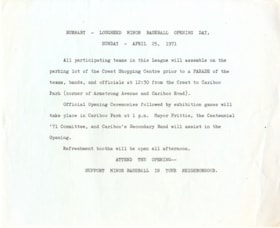
- Leaflet; mimeographed print on blue cartridge paper. Typewritten text in black; title at top reads: "BURNABY-LOUGHEED MINOR BASEBALL OPENING DAY, / SUNDAY - APRIL 25, 1971"; text beneath providing details; text at bottom reads "ATTEND THE OPENING -- / SUPPORT MINOR BASEBALL IN YOUR NEIGHBORHOOD".
- Object History
- Flier for Minor Baseball teams to assemble for a parade during the official opening ceremonies of Burnaby's Centennial celebrations followed by exhibtion games at Cariboo Park.
- Category
- 08. Communication Artifacts
- Classification
- Advertising Media
- Object Term
- Leaflet
- Colour
- Blue
- Measurements
- Length: 21.5 cm x Width: 17.5 cm
- Country Made
- Canada
- Province Made
- British Columbia
- Site/City Made
- Burnaby
- Publication Date
- April 1971
Images

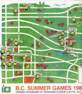
Map
https://search.heritageburnaby.ca/link/museumartifact90944
- Repository
- Burnaby Village Museum
- Accession Code
- BV021.4.30
- Description
- BC Summer Games Cartoon Map of Burnaby. Location of sporting events are labeled with cartoon bees holding signs with flowers. BC Games logo is in the bottom right, with "B.C. SUMMER GAMES 1984 BURNABY B.C./ Opening Ceremonies at Swangaurd Stadium, 6:30 P.M. July 19th...Come Out and Join the the Fun!"
- Object History
- Item pertaining to BC Summer Games which took place in Burnaby July 19-22, 1984.
- Category
- 08. Communication Artifacts
- Classification
- Documentary Artifacts - - Graphic Documents
- Object Term
- Cartograph, Map
- Colour
- White
- Green
- Measurements
- 25 cm high x 35 cm wide
- Subjects
- Sports
- Recreational Activities
Images

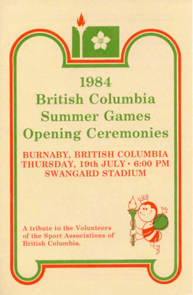
Program
https://search.heritageburnaby.ca/link/museumartifact90945
- Repository
- Burnaby Village Museum
- Accession Code
- BV021.4.31
- Description
- 1984 BC Summer Games Opening Ceremonies Programme. Beige folded book with Summer Games Logo in green at top with green and red decorative lines around text. Cartoon bee in bottom left holding a torch. "Burnaby, British Columbia/ Thursday, 19th July - 6:00 PM/ Swangard Stadium" Back has Shell logo with "Come to Shell for milage/ Shellburn Refinery"
- Object History
- Item pertaining to BC Summer Games which took place in Burnaby July 19-22, 1984.
- Category
- 08. Communication Artifacts
- Classification
- Documentary Artifacts - - Other Documents
- Object Term
- Program
- Colour
- Beige
- Green
- Red
- Measurements
- 22 cm high x 14 cm wide
- Subjects
- Sports
- Recreational Activities
Images
