Narrow Results By

Canada Way
https://search.heritageburnaby.ca/link/archivedescription79957
- Repository
- City of Burnaby Archives
- Date
- September, 1976
- Collection/Fonds
- Burnaby Public Library Contemporary Visual Archive Project
- Description Level
- Item
- Physical Description
- 1 photograph : b&w ; 11 x 16 cm mounted on cardboard
- Scope and Content
- Photograph shows a view looking west along Canada Way, taken from Westminster Avenue.
- Repository
- City of Burnaby Archives
- Date
- September, 1976
- Collection/Fonds
- Burnaby Public Library Contemporary Visual Archive Project
- Physical Description
- 1 photograph : b&w ; 11 x 16 cm mounted on cardboard
- Description Level
- Item
- Record No.
- 556-522
- Access Restriction
- No restrictions
- Reproduction Restriction
- Reproduce for fair dealing purposes only
- Accession Number
- 2013-13
- Scope and Content
- Photograph shows a view looking west along Canada Way, taken from Westminster Avenue.
- Subjects
- Aerial Photographs
- Media Type
- Photograph
- Photographer
- Campbell, Peg
- Notes
- Scope note taken directly from BPL photograph description.
- 1 b&w copy negative : 10 x 12.5 cm accompanying
- Geographic Access
- Canada Way
- Westminster Avenue
- Planning Study Area
- Douglas-Gilpin Area
Images

![Aerial photograph of the Burnaby Village area, [1946] (date of original), copied 1991 thumbnail](/media/hpo/_Data/_Archives_Images/_Unrestricted/370/370-532.jpg?width=280)
Aerial photograph of the Burnaby Village area
https://search.heritageburnaby.ca/link/archivedescription37945
- Repository
- City of Burnaby Archives
- Date
- [1946] (date of original), copied 1991
- Collection/Fonds
- Burnaby Historical Society fonds
- Description Level
- Item
- Physical Description
- 1 photograph : b&w ; 3.5 x 4.4 cm print on contact sheet 20.5 x 26.7 cm
- Scope and Content
- Aerial photograph of the Sperling Avenue/Douglas Road Burnaby Village area.
- Repository
- City of Burnaby Archives
- Date
- [1946] (date of original), copied 1991
- Collection/Fonds
- Burnaby Historical Society fonds
- Subseries
- Burnaby Image Bank subseries
- Physical Description
- 1 photograph : b&w ; 3.5 x 4.4 cm print on contact sheet 20.5 x 26.7 cm
- Description Level
- Item
- Record No.
- 370-532
- Access Restriction
- No restrictions
- Reproduction Restriction
- No known restrictions
- Accession Number
- BHS1999-03
- Scope and Content
- Aerial photograph of the Sperling Avenue/Douglas Road Burnaby Village area.
- Subjects
- Aerial Photographs
- Media Type
- Photograph
- Notes
- Title based on contents of photograph
- 1 b&w copy negative accompanying
- Negative has a pink cast
- Geographic Access
- Douglas Road
- Sperling Avenue
- Canada Way
- Historic Neighbourhood
- Burnaby Lake (Historic Neighbourhood)
Images
![Aerial photograph of the Burnaby Village area, [1946] (date of original), copied 1991 thumbnail](/media/hpo/_Data/_Archives_Images/_Unrestricted/370/370-532.jpg)

A Pig's Tale
https://search.heritageburnaby.ca/link/museumdescription14365
- Repository
- Burnaby Village Museum
- Date
- Oct. 2020
- Collection/Fonds
- Burnaby Village Museum fonds
- Description Level
- Item
- Physical Description
- 3 video recordings (mp4) (5 min., 28 sec.) : digital, col., sd., stereo, subtitles
- Scope and Content
- Item consists of part two in a two part video series "A Taste of History" created by Debbie Liang and Joty Gill, University of British Columbia alumni and graduates from the Asian Canadian & Asian Migration Studies program (ACAM). Part two is titled "A Pig's Tale". The film highlights the history o…
- Repository
- Burnaby Village Museum
- Collection/Fonds
- Burnaby Village Museum fonds
- Series
- UBC Partnership series
- Description Level
- Item
- Physical Description
- 3 video recordings (mp4) (5 min., 28 sec.) : digital, col., sd., stereo, subtitles
- Material Details
- Script: Debbie Liang; Joty Gill Narration: Joty Gill Editor: Debbie Liang Subtitles: English; Simplified Chinese; Traditional Chinese Video Appearances: Kathy Lee; Eleanor Lee Illustrations and Animations: Debbie Liang Photos, Images & B-roll: Piggery photo, image courtesy of Elwin Xie; Douglas Road: City of Burnaby Archives, 477-841; Canada Way, City of Burnaby Archives, 556-522, photo by Peg Campbell; Red pig by Debbie Liang; Piglets sleeping, image courtesy of RoyBuri from pixabay, free to use; Chinese Zodiac, image courtesy of RoofOfAllLight from wikimedia, Creative Commons Attribution-Share Alike 4.0 International license; Pictograph for Home by Debbie Liang; Pigs lying down, image courtesy of Elwin Xie; Council minutes all from heritageburnaby.com; Cleanliness illustration set by Debbie Liang; "The Heathen Chinese in British Columbia" from Library and Archives Canada; Laundryman spitting from Daily News, Prince Rupert in 1911; Slicer on counter at Way Sang Yuen Wat Kee & Co., Burnaby Village Museum BV017.7.290; Way Sang Yuen Wat Kee & Co. Store front, Burnaby Village Museum BV017.7.191; Medical Practices Disagreement illustration by Debbie Liang; Butchering pig, image courtesy of Elwin Xie; Chinatown brolls, courtesy of Food2 group from UBC's 2019 ACAM 390 Class; Black Rotary telephone beside ball pen on white printed paper, image courtesy of Pixabay from pexels.com, free to use; Burnaby Lake on a cloudy day, image courtesy of Flying Pegunin from wikipedia; The Vancouver Sun May 4, 1921 from newspapers.com; Vancouver Daily May 3, 1921 from newspapers.com; Reduce number of pigs illustration by Debbie Liang; Black and white photo of piggery, image courtesy of Elwin Xie; 2019 Piggery illustration by Debbie Liang Music and Sound Effects: "Acoustic Mediation 2" from audionautix; Pig Grunting sounds from Kiddopedia Animasl, Creative Commons 0; "Piano moment" & "November" from bensound.com; "Ding sound effect" from freesoundlibrary; Wuxia2_Guzheng_Pipa by PeriTune http://peritune.com; Music promoted by https://www.free-stock-music.com; Attribution 4.0 International (CC BY 4.0) https://creativecommons.org/licenses/by/4.0/ Video adapted from 2019 BVM intern project by Debbie Liang and Marcela Gomez Special thanks to: UBC: Joanna Yang, Jenny Lu, Denise Fong, Henry Yu; BVM: Kate Petrusa, Amy Wilson Changes to music may have been made for the purposes of this video
- Scope and Content
- Item consists of part two in a two part video series "A Taste of History" created by Debbie Liang and Joty Gill, University of British Columbia alumni and graduates from the Asian Canadian & Asian Migration Studies program (ACAM). Part two is titled "A Pig's Tale". The film highlights the history of Chinese pig farms also known as "Piggeries" in Burnaby. The film tells the story of how many of these farms were established by Chinese immigrants along Douglas Road (now Canada Way) between the 1890s and 1920s; the importance of the pig in the Chinese Culture as well as a way for Chinese immigrants to make a living and the racism and discriminatory bylaws that the Chinese pig farmers suffered that finally led to the closure of many of these farms. Content references three documented piggery ranches along Douglas Road: Ah Sam; Young Chung and Hop Hin Yen. The films are supported with voice over in english, subtitles, animation along with historical photographs. One version of the film is supported with subtitles in English while two other versions of the film are supported with subtitles in Simplified Chinese and Traditional Chinese.
- History
- In 2020, due to the restrictions of COVID-19, University of British Columbia student interns with the Burnaby Village Museum Chinese Canadian History in Burnaby project were asked to create virtual experiences to reimagine Burnaby Village Museum's historical Chinese Canadian programming in remote online spaces. Debbie Liang and Joty Gill (UBC alumni and graduates of Dr. Henry Yu's 2019 summer ACAM 390A Global Seminar to Aisa) returned to work with Burnaby Village Museum to create two short films showcasing the history of Chinese Canadian Chop Suey restaurants and piggeries in Burnaby.
- Creator
- Liang, Debbie
- Debbie Liang
- Subjects
- Persons - Chinese Canadians
- Social Issues - Discrimination
- Social Issues - Racism
- Regulations
- Agriculture
- Agriculture - Farms
- Agriculture - Ranches
- Animals - Pigs
- Names
- Liang, Debbie
- Gill, Joty
- Burnaby Village Museum
- University of British Columbia
- Xie, Elwin
- Way Sang Yuen Wat Kee & Company
- Ah Sam
- Young Chung
- Hop Hin Yen
- Responsibility
- University of British Columbia
- UBC Initiative for Student Teaching and Research in Chinese Canadian Studies
- Burnaby Village Museum
- Geographic Access
- Douglas Road
- Canada Way
- Accession Code
- BV020.28.7
- Access Restriction
- No restrictions
- Reproduction Restriction
- No known restrictions
- Date
- Oct. 2020
- Media Type
- Moving Images
- Historic Neighbourhood
- Burnaby Lake (Historic Neighbourhood)
- Planning Study Area
- Douglas-Gilpin Area
- Notes
- Transcribed title
Images


Video
A Pig's Tale, Oct. 2020
A Pig's Tale, Oct. 2020
https://search.heritageburnaby.ca/media/hpo/_Data/_BVM_Moving_Images/2020_0028_0007_001.mp4
Highway No. 1
https://search.heritageburnaby.ca/link/archivedescription79950
- Repository
- City of Burnaby Archives
- Date
- September, 1976
- Collection/Fonds
- Burnaby Public Library Contemporary Visual Archive Project
- Description Level
- Item
- Physical Description
- 1 photograph : b&w ; 11 x 16 cm mounted on cardboard
- Scope and Content
- Photograph shows a view of the No. 1 Highway looking northwest from Sprott Street overpass.
- Repository
- City of Burnaby Archives
- Date
- September, 1976
- Collection/Fonds
- Burnaby Public Library Contemporary Visual Archive Project
- Physical Description
- 1 photograph : b&w ; 11 x 16 cm mounted on cardboard
- Description Level
- Item
- Record No.
- 556-520
- Access Restriction
- No restrictions
- Reproduction Restriction
- Reproduce for fair dealing purposes only
- Accession Number
- 2013-13
- Scope and Content
- Photograph shows a view of the No. 1 Highway looking northwest from Sprott Street overpass.
- Subjects
- Aerial Photographs
- Media Type
- Photograph
- Photographer
- Salmon, Stu
- Notes
- Scope note taken directly from BPL photograph description.
- 1 b&w copy negative : 10 x 12.5 cm accompanying
- Geographic Access
- Trans Canada Highway
- Historic Neighbourhood
- Burnaby Lake (Historic Neighbourhood)
- Planning Study Area
- Douglas-Gilpin Area
Images


Highway No. 1
https://search.heritageburnaby.ca/link/archivedescription79977
- Repository
- City of Burnaby Archives
- Date
- September 23, 1976
- Collection/Fonds
- Burnaby Public Library Contemporary Visual Archive Project
- Description Level
- Item
- Physical Description
- 1 photograph : b&w ; 11 x 16 cm mounted on cardboard
- Scope and Content
- Photograph shows a view of underdeveloped area and the No. 1 Highway looking northwest from the Sperling Overpass with Capitol Hill in the background.
- Repository
- City of Burnaby Archives
- Date
- September 23, 1976
- Collection/Fonds
- Burnaby Public Library Contemporary Visual Archive Project
- Physical Description
- 1 photograph : b&w ; 11 x 16 cm mounted on cardboard
- Description Level
- Item
- Record No.
- 556-533
- Access Restriction
- No restrictions
- Reproduction Restriction
- Reproduce for fair dealing purposes only
- Accession Number
- 2013-13
- Scope and Content
- Photograph shows a view of underdeveloped area and the No. 1 Highway looking northwest from the Sperling Overpass with Capitol Hill in the background.
- Subjects
- Aerial Photographs
- Media Type
- Photograph
- Photographer
- Campbell, Peg
- Notes
- Scope note taken directly from BPL photograph description.
- 1 b&w copy negative : 10 x 12.5 cm accompanying
- Geographic Access
- Trans Canada Highway
- Planning Study Area
- Ardingley-Sprott Area
Images


Stormont Overpass
https://search.heritageburnaby.ca/link/archivedescription45376
- Repository
- City of Burnaby Archives
- Date
- August 1978
- Collection/Fonds
- Columbian Newspaper collection
- Description Level
- Item
- Physical Description
- 1 photograph : b&w ; 12.5 x 24 cm
- Scope and Content
- Aerial photograph of Stormont Overpass which would provide a direct link from the Trans Canada Highway (previously named the 401 Freeway) to the Lougheed Highway and Simon Fraser University. This was taken when the excavation work was completed, and grading and paving still need to be done.
- Repository
- City of Burnaby Archives
- Date
- August 1978
- Collection/Fonds
- Columbian Newspaper collection
- Physical Description
- 1 photograph : b&w ; 12.5 x 24 cm
- Description Level
- Item
- Record No.
- 480-271
- Access Restriction
- No restrictions
- Reproduction Restriction
- No restrictions
- Accession Number
- 2003-02
- Scope and Content
- Aerial photograph of Stormont Overpass which would provide a direct link from the Trans Canada Highway (previously named the 401 Freeway) to the Lougheed Highway and Simon Fraser University. This was taken when the excavation work was completed, and grading and paving still need to be done.
- Media Type
- Photograph
- Photographer
- Hodge, Craig
- Notes
- Title based on contents of photograph
- Note in pencil on verso of photograph reads: "Altair Aviation / photo by / Craig Hodge"
- Geographic Access
- Cariboo Road
- Gaglardi Way
- Trans Canada Highway
- Historic Neighbourhood
- Burquitlam (Historic Neighbourhood)
- Planning Study Area
- Burnaby Lake Area
- Cameron Area
Images


Stormont Overpass
https://search.heritageburnaby.ca/link/archivedescription45377
- Repository
- City of Burnaby Archives
- Date
- August 1978
- Collection/Fonds
- Columbian Newspaper collection
- Description Level
- Item
- Physical Description
- 1 photograph : b&w ; 16.5 x 24 cm
- Scope and Content
- Aerial photograph of Stormont Overpass which would provide a direct link from the 401 Freeway to the Lougheed Highway and Simon Fraser University. This was taken when the excavation work was completed, and grading and paving still need to be done.
- Repository
- City of Burnaby Archives
- Date
- August 1978
- Collection/Fonds
- Columbian Newspaper collection
- Physical Description
- 1 photograph : b&w ; 16.5 x 24 cm
- Description Level
- Item
- Record No.
- 480-272
- Access Restriction
- No restrictions
- Reproduction Restriction
- No restrictions
- Accession Number
- 2003-02
- Scope and Content
- Aerial photograph of Stormont Overpass which would provide a direct link from the 401 Freeway to the Lougheed Highway and Simon Fraser University. This was taken when the excavation work was completed, and grading and paving still need to be done.
- Media Type
- Photograph
- Photographer
- Hodge, Craig
- Notes
- Title based on contents of photograph
- Newspaper clipping attached to verso of photograph reads: "After six years, work on the Stormont interchange in Burnaby is only a few weeks from completion. The huge clover-leaf junction of Gaglardi Way and the Freeway is on the top left-hand corner, with Gaglardi Way approaching from the bottom right where a bridge has been completed over the Burlington Northern tracks. An embankment linking that bridge with one over the Brunette River awaits only a layer of tarmac, and a path has been cleared through the woods to link up with the clover-leaf. The present access to the Freeway is along the road running from the left to right across the middle of the picture. The interchange will open next month."
- Note in pencil on verso of photograph reads: "Altair Aviation / photo by / Craig Hodge"
- Geographic Access
- Cariboo Road
- Gaglardi Way
- Trans Canada Highway
- Historic Neighbourhood
- Burquitlam (Historic Neighbourhood)
- Planning Study Area
- Burnaby Lake Area
- Cameron Area
Images

![Stormont Overpass, [1978] thumbnail](/media/hpo/_Data/_Archives_Images/_Unrestricted/480/480-275.jpg?width=280)
Stormont Overpass
https://search.heritageburnaby.ca/link/archivedescription45380
- Repository
- City of Burnaby Archives
- Date
- [1978]
- Collection/Fonds
- Columbian Newspaper collection
- Description Level
- Item
- Physical Description
- 1 photograph : b&w ; 16 x 24 cm
- Scope and Content
- Aerial photograph of Stormont Overpass which would provide a direct link from the Trans Canada Highway (previously named the 401 Freeway) to the Lougheed Highway and Simon Fraser University. This was taken when the excavation work was completed, and paving still need to be done.
- Repository
- City of Burnaby Archives
- Date
- [1978]
- Collection/Fonds
- Columbian Newspaper collection
- Physical Description
- 1 photograph : b&w ; 16 x 24 cm
- Description Level
- Item
- Record No.
- 480-275
- Access Restriction
- No restrictions
- Reproduction Restriction
- No restrictions
- Accession Number
- 2003-02
- Scope and Content
- Aerial photograph of Stormont Overpass which would provide a direct link from the Trans Canada Highway (previously named the 401 Freeway) to the Lougheed Highway and Simon Fraser University. This was taken when the excavation work was completed, and paving still need to be done.
- Media Type
- Photograph
- Photographer
- King, Basil
- Notes
- Title based on contents of photograph
- Note on verso of photograph reads: "One of the biggest Highways"
- Geographic Access
- Cariboo Road
- Gaglardi Way
- Trans Canada Highway
- Historic Neighbourhood
- Burquitlam (Historic Neighbourhood)
- Planning Study Area
- Burnaby Lake Area
- Cameron Area
Images
![Stormont Overpass, [1978] thumbnail](/media/hpo/_Data/_Archives_Images/_Unrestricted/480/480-275.jpg)
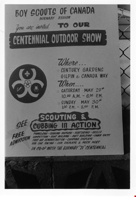
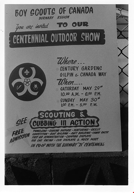
Boy Scouts Centennial Outdoor Show poster
https://search.heritageburnaby.ca/link/museumdescription2186
- Repository
- Burnaby Village Museum
- Date
- May 1971
- Collection/Fonds
- Donald Copan collection
- Description Level
- Item
- Physical Description
- 1 photograph : b&w ; 8.9 x 12.7 cm
- Scope and Content
- Photograph of poster for "Boy Scouts of Canada Burnaby Region Centennial Outdoor Show" at Century Gardens.
- Repository
- Burnaby Village Museum
- Collection/Fonds
- Donald Copan collection
- Series
- Copan album series
- Description Level
- Item
- Physical Description
- 1 photograph : b&w ; 8.9 x 12.7 cm
- Scope and Content
- Photograph of poster for "Boy Scouts of Canada Burnaby Region Centennial Outdoor Show" at Century Gardens.
- Subjects
- Organizations - Boys' Societies and Clubs
- Advertising Medium - Poster
- Celebrations - Centennials
- Names
- Boy Scouts of Canada
- Accession Code
- BV005.54.234
- Access Restriction
- No restrictions
- Reproduction Restriction
- May be restricted by third party rights
- Date
- May 1971
- Media Type
- Photograph
- Scan Resolution
- 600
- Scan Date
- July 21, 2020
- Scale
- 100
- Notes
- Title based on contents of photograph
Images
Interview with Honourable Raj Chouhan
https://search.heritageburnaby.ca/link/museumdescription19349
- Repository
- Burnaby Village Museum
- Date
- [1957-2022] (interview content), interviewed 2 Dec. 2022
- Collection/Fonds
- Burnaby Village Museum fonds
- Description Level
- Item
- Physical Description
- 1 sound recording (wav) + 1 sound recording (mp3) (49 min., 21 sec.)
- Scope and Content
- Item consists of an oral history interview with Honourable Raj Chouhan conducted by Burnaby Village Museum Assistant Curator, Kate Petrusa. Raj Chouhan shares his ancestral background and personal experiences immigrating to Canada from India in 1973 and living and working in Canada as an immigrant…
- Repository
- Burnaby Village Museum
- Collection/Fonds
- Burnaby Village Museum fonds
- Series
- Museum Oral Histories series
- Description Level
- Item
- Physical Description
- 1 sound recording (wav) + 1 sound recording (mp3) (49 min., 21 sec.)
- Material Details
- Interviewer: Kate Petrusa Interviewee: Honourable Raj Chouhan Location of Interview: Residence of Honourable Raj Chouhan Interview Date: December 2, 2022 Total Number of tracks: 1 Total Length of all Tracks: (00:49:21) Digital master recording (wav) was converted to mp3 for access on Heritage Burnaby
- Scope and Content
- Item consists of an oral history interview with Honourable Raj Chouhan conducted by Burnaby Village Museum Assistant Curator, Kate Petrusa. Raj Chouhan shares his ancestral background and personal experiences immigrating to Canada from India in 1973 and living and working in Canada as an immigrant and the organizations that he became involved with. Honourable Raj Chouhan recalls how he arrived in Burnaby with his family in 1973 and that his family worked in farming. Chouhan imparts his first hand experiences as a new immigrant working as a labourer in the farming industry and describes the unsafe and unfair working conditions that he and migrant workers faced. Chouhan conveys how this experience lead him to become an activist for better working conditions for migrant workers. This lead Chouhan and others to form the Canadian Farm Workers Union in 1980. Chouhan recollects his experiences flying from India to Canada with his wife, his first impressions after arriving in Vancouver and driving to Burnaby and what he brought with him. Chouhan explains his connections to Burnaby. Members of Chouhan's wife's family immgrated to Canada in 1957 and his wife and her three brothers joined them in 1970. Chouhan's father in law, Hardial Singh Grewal immigrated in 1957 and became president of the Sikh temple in New Westminster. Hardial Singh Grewal worked in a lumber mill in Vancouver and eventually bought a house in Burnaby. Chouhan married to his wife at the Sikh temple in New Westminster and lived in Burnaby for a period before moving to New Westminster where they could find more affordable housing. Chouhan shares that he first worked as a farm labourer in Abbotsford and then found a job in the sawmill which paid more. Chouhan describes the extreme racism and discrimination that he and other immigrants faced which lead to the formation of the British Columbia Organization to Fight Racism under the leadership of Dr. Hari Prakash Sharma. Chouhan describes this organization that he was a part of and the Canadian Farm Workers Union that were both formed in Burnaby. Chouhan shares that he moved to Victoria in 1988 to serve on the Hospital Employee's Union and moved back to the mainland in 1993 and returned to Burnaby in 2001. Chouhan reflects on the history of South Asian immigration in Canada, how many of the migrants settled in the lower mainland including Burnaby, New Westminster and Vancouver establishing temples in Vancouver and New Westminster which became the centre for the South Asian community. He conveys how earlier occupations were limited to farming and millwork and how over time employment opportunities and education have broadened but there is still work to do. He imparts how second generation Canadians’ experiences differ from first generations providing examples of his own daughters’ and the occupations that they are working in. Chouhan provides his insights into the South Asian Canadian experience imparting “We make history every day and that history needs to be recorded and learned from.."... “People from different communities, different backgrounds who lived in Burnaby have contributed so much and South Asians are just like another community and participated in all aspects of social life, cultural, religious, economy. I'm so proud of our community, our forefathers who had that vision to fight for our rights. I'm inspired by people who struggled so much to gain basic rights, like the right to vote". Chouhan refers to these first immigrants as “Gadri Babbas” “revolutionary old people” who were also the main motivation that lead to India becoming a free country in 1947 and for fighting for basic rights here in Canada and how they made their contributions for future generations. Chouhan expresses what he imparts to students “Do not forget your past... if you remember your past then you are much more knowledgeable. Then we know what we need for the future. If we don't know the past, we don't know what the future is going to be like. To make a better future, you have to learn from the past and improve".
- History
- Interviewee biography: Honourable Raj Chouhan was born in the city of Ludhiana in the Province of Punjab in India and immigrated to Canada in 1973. After arriving in Canada, Raj's family settled in Burnaby. Raj grew up in Burnaby and attended schoool. Honourable Raj Chouhan was elected to the Legislative Assembly of British Columbia as the MLA for Burnaby-Edmonds in 2005 and was re-elected in 2009, 2013, 2017 and 2020. He was elected Speaker of the Legislative Assembly on December 7, 2020. Honourable Chouhan is the founding president of the Canadian Farmworkers Union and the British Columbia Organization to Fight Racism and has served as a director of the Hospital Employees' Union, the Labour Relations Board of B.C. and the Arbitration Bureau of B.C. Honourable Chouhan has also served as the Vice President of B.C. Human Rights Defenders since 2003 and has taught courses in Human Rights, the B.C. Labour Code and Collective Bargaining since 1987. Interviewer biography: Kate Petrusa is the Assistant Curator at the Burnaby Village Museum. In her role, she manages all aspects of the collection – including caring for physical artifacts and making their digital counterpart accessible. Before coming to Burnaby Village Museum in 2019, Kate has worked at several Museums around the Lower Mainland as a Curator and contractor since 2013.
- Creator
- Burnaby Village Museum
- Subjects
- Persons - South Asian Canadians
- Social Issues
- Social Issues - Racism
- Occupations - Agricultural Labourers
- Migration
- Organizations - Unions
- Rights
- Rights - Human Rights
- Agriculture
- Agriculture - Farms
- Government - Provincial Government
- Government
- Names
- Chouhan, Raj
- British Columbia Organization to Fight Racism
- Sharma, Dr. Hari Prakash
- Grewal, Hardial Singh
- Canadian Farmworkers Union
- Hospital Employees Union
- Khalsa Diwan Society
- Responsibility
- Petrusa, Kate
- Accession Code
- BV022.29.4
- Access Restriction
- No restrictions
- Reproduction Restriction
- No known restrictions
- Date
- [1957-2022] (interview content), interviewed 2 Dec. 2022
- Media Type
- Sound Recording
- Notes
- Title based on contents of item
- Transcription available on Heritage Burnaby
Documents
Audio Tracks
Interview with Honourable Raj Chouhan, [1957-2022] (interview content), interviewed 2 Dec. 2022
Interview with Honourable Raj Chouhan, [1957-2022] (interview content), interviewed 2 Dec. 2022
https://search.heritageburnaby.ca/media/hpo/_Data/_BVM_Sound_Recordings/Oral_Histories/2022_0029_0004_002.mp3Interview with Maureen Olofson by Kathy Bossort October 14, 2015 - Track 1
https://search.heritageburnaby.ca/link/oralhistory569
- Repository
- City of Burnaby Archives
- Date Range
- 1906-1950
- Length
- 0:09:08
- Summary
- This portion of the interview is about Maureen Olofson’s parents immigration to Saskatchewan, her mother Kerstin in 1912 and father Axel in 1928, Maureen’s birth on a trip to Sweden in 1938, and her family’s move to Burnaby in 1942 and the start of their mink ranch, the GAK Fur Farm, near Curtis Av…
- Repository
- City of Burnaby Archives
- Summary
- This portion of the interview is about Maureen Olofson’s parents immigration to Saskatchewan, her mother Kerstin in 1912 and father Axel in 1928, Maureen’s birth on a trip to Sweden in 1938, and her family’s move to Burnaby in 1942 and the start of their mink ranch, the GAK Fur Farm, near Curtis Avenue in the old Hastings Grove subdivision on Burnaby Mountain.
- Date Range
- 1906-1950
- Length
- 0:09:08
- Subjects
- Agriculture
- Geographic Access
- Burnaby Mountain Conservation Area
- Historic Neighbourhood
- Lochdale (Historic Neighbourhood)
- Planning Study Area
- Westridge Area
- Interviewer
- Bossort, Kathy
- Interview Date
- October 14, 2015
- Scope and Content
- Recording is of an interview with Maureen Olofson conducted by Kathy Bossort. Maureen Olofson was one of 23 participants interviewed as part of the Community Heritage Commission’s Burnaby Mountain Oral History Project. The interview is mainly about Maureen Olofson’s memories of growing up on her parent’s Burnaby Mountain mink ranch between 1942 and 1950 and about the operation of the farm. She also talks about her parents’ history, her teaching career, and her thoughts about the beauty and value of Burnaby Mountain’s natural area.
- Biographical Notes
- Maureen Olofson was born 1938 in Glote, Harjedalen, Sweden, to Axel (1906-1998) and Kerstin Margareta (1906-1980). Axel and Kerstin Olofson, who had separately immigrated to Canada in 1928 and 1913 respectively, married in Canada and then returned to Sweden where Maureen was born. They moved to Burnaby in 1942 with their daughters Maureen and Anita Lea, and bought land and a mink ranch on Burnaby Mountain with their partners Gus Skofteby and Karin Ericksson (Kerstin’s sister). The GAK Fur Farm, located in the old Hastings Grove subdivision on 4th Avenue near Curtis Street, was one of the largest mink ranches in BC, an award winning operation with over 1200 mink animals. In 1950 the partners sold the land and the Olofson family moved to rented homes on Sperling Avenue. In 1952 Axel sold the last of his minks and opened a sporting goods store on Hastings Street. In 1954 the family moved to North Vancouver where Axel Olofson reestablished his sports business. Maureen attended Sperling Avenue School from Gr. 1 to Gr. 8 and Burnaby North High School to Gr. 11, completing school in North Vancouver, before going to UBC where she trained as a teacher. She returned to Burnaby in 1977 to teach, retiring in 1997. She is a volunteer with the Swedish Canadian Rest Home Association and the Dania Homes Society. Maureen continues to enjoy activities on Burnaby Mountain and works toward preserving the natural beauty of the mountain.
- Total Tracks
- 8
- Total Length
- 1:19:04
- Interviewee Name
- Olofson, B. Maureen
- Interview Location
- Maureen Olofson's home in Burnaby
- Interviewer Bio
- Kathy Bossort is a retired archivist living in Ladner, BC. She worked at the Delta Museum and Archives after graduating from SLAIS (UBC) in 2001 with Masters degrees in library science and archival studies. Kathy grew up in Calgary, Alberta, and, prior to this career change, she lived in the West Kootenays, earning her living as a cook for BC tourist lodges and work camps. She continues to be interested in oral histories as a way to fill the gaps in the written record and bring richer meaning to history.
- Collection/Fonds
- Community Heritage Commission Special Projects fonds
- Media Type
- Sound Recording
Audio Tracks
Track one of interview with Maureen Olofson
Track one of interview with Maureen Olofson
https://search.heritageburnaby.ca/media/hpo/_Data/_Archives_Oral_Histories/_Unrestricted/MSS196-004/MSS196-004_Track_1.mp3Interview with Maureen Olofson by Kathy Bossort October 14, 2015 - Track 2
https://search.heritageburnaby.ca/link/oralhistory570
- Repository
- City of Burnaby Archives
- Date Range
- 1942-1952
- Length
- 0:14:54
- Summary
- This portion of the interview is about Maureen Olofson’s description of the operation and location of the Olofson’s mink ranch, the challenges of raising mink, and when the family gave up the farm in 1950/51. She describes how she and her sister Anita Lea used a bicycle to go to school.
- Repository
- City of Burnaby Archives
- Summary
- This portion of the interview is about Maureen Olofson’s description of the operation and location of the Olofson’s mink ranch, the challenges of raising mink, and when the family gave up the farm in 1950/51. She describes how she and her sister Anita Lea used a bicycle to go to school.
- Date Range
- 1942-1952
- Length
- 0:14:54
- Geographic Access
- Burnaby Mountain Conservation Area
- Historic Neighbourhood
- Lochdale (Historic Neighbourhood)
- Planning Study Area
- Westridge Area
- Interviewer
- Bossort, Kathy
- Interview Date
- October 14, 2015
- Scope and Content
- Recording is of an interview with Maureen Olofson conducted by Kathy Bossort. Maureen Olofson was one of 23 participants interviewed as part of the Community Heritage Commission’s Burnaby Mountain Oral History Project. The interview is mainly about Maureen Olofson’s memories of growing up on her parent’s Burnaby Mountain mink ranch between 1942 and 1950 and about the operation of the farm. She also talks about her parents’ history, her teaching career, and her thoughts about the beauty and value of Burnaby Mountain’s natural area.
- Biographical Notes
- Maureen Olofson was born 1938 in Glote, Harjedalen, Sweden, to Axel (1906-1998) and Kerstin Margareta (1906-1980). Axel and Kerstin Olofson, who had separately immigrated to Canada in 1928 and 1913 respectively, married in Canada and then returned to Sweden where Maureen was born. They moved to Burnaby in 1942 with their daughters Maureen and Anita Lea, and bought land and a mink ranch on Burnaby Mountain with their partners Gus Skofteby and Karin Ericksson (Kerstin’s sister). The GAK Fur Farm, located in the old Hastings Grove subdivision on 4th Avenue near Curtis Street, was one of the largest mink ranches in BC, an award winning operation with over 1200 mink animals. In 1950 the partners sold the land and the Olofson family moved to rented homes on Sperling Avenue. In 1952 Axel sold the last of his minks and opened a sporting goods store on Hastings Street. In 1954 the family moved to North Vancouver where Axel Olofson reestablished his sports business. Maureen attended Sperling Avenue School from Gr. 1 to Gr. 8 and Burnaby North High School to Gr. 11, completing school in North Vancouver, before going to UBC where she trained as a teacher. She returned to Burnaby in 1977 to teach, retiring in 1997. She is a volunteer with the Swedish Canadian Rest Home Association and the Dania Homes Society. Maureen continues to enjoy activities on Burnaby Mountain and works toward preserving the natural beauty of the mountain.
- Total Tracks
- 8
- Total Length
- 1:19:04
- Interviewee Name
- Olofson, B. Maureen
- Interview Location
- Maureen Olofson's home in Burnaby
- Interviewer Bio
- Kathy Bossort is a retired archivist living in Ladner, BC. She worked at the Delta Museum and Archives after graduating from SLAIS (UBC) in 2001 with Masters degrees in library science and archival studies. Kathy grew up in Calgary, Alberta, and, prior to this career change, she lived in the West Kootenays, earning her living as a cook for BC tourist lodges and work camps. She continues to be interested in oral histories as a way to fill the gaps in the written record and bring richer meaning to history.
- Collection/Fonds
- Community Heritage Commission Special Projects fonds
- Media Type
- Sound Recording
Audio Tracks
Track two of interview with Maureen Olofson
Track two of interview with Maureen Olofson
https://search.heritageburnaby.ca/media/hpo/_Data/_Archives_Oral_Histories/_Unrestricted/MSS196-004/MSS196-004_Track_2.mp3Interview with Maureen Olofson by Kathy Bossort October 14, 2015 - Track 3
https://search.heritageburnaby.ca/link/oralhistory571
- Repository
- City of Burnaby Archives
- Date Range
- 1942-1980
- Length
- 0:06:55
- Summary
- This portion of the interview is about Maureen Olofson’s description of the food sources on the farm including the garden, food animals, berry picking and bears. She also describes what her parents did after giving up the farm, opening sporting good stores on Hastings Street and then in North Vanco…
- Repository
- City of Burnaby Archives
- Summary
- This portion of the interview is about Maureen Olofson’s description of the food sources on the farm including the garden, food animals, berry picking and bears. She also describes what her parents did after giving up the farm, opening sporting good stores on Hastings Street and then in North Vancouver.
- Date Range
- 1942-1980
- Length
- 0:06:55
- Names
- Olofson, Axel
- GAK Fur Farm
- Geographic Access
- Burnaby Mountain Conservation Area
- Historic Neighbourhood
- Lochdale (Historic Neighbourhood)
- Planning Study Area
- Westridge Area
- Lochdale Area
- Interviewer
- Bossort, Kathy
- Interview Date
- October 14, 2015
- Scope and Content
- Recording is of an interview with Maureen Olofson conducted by Kathy Bossort. Maureen Olofson was one of 23 participants interviewed as part of the Community Heritage Commission’s Burnaby Mountain Oral History Project. The interview is mainly about Maureen Olofson’s memories of growing up on her parent’s Burnaby Mountain mink ranch between 1942 and 1950 and about the operation of the farm. She also talks about her parents’ history, her teaching career, and her thoughts about the beauty and value of Burnaby Mountain’s natural area.
- Biographical Notes
- Maureen Olofson was born 1938 in Glote, Harjedalen, Sweden, to Axel (1906-1998) and Kerstin Margareta (1906-1980). Axel and Kerstin Olofson, who had separately immigrated to Canada in 1928 and 1913 respectively, married in Canada and then returned to Sweden where Maureen was born. They moved to Burnaby in 1942 with their daughters Maureen and Anita Lea, and bought land and a mink ranch on Burnaby Mountain with their partners Gus Skofteby and Karin Ericksson (Kerstin’s sister). The GAK Fur Farm, located in the old Hastings Grove subdivision on 4th Avenue near Curtis Street, was one of the largest mink ranches in BC, an award winning operation with over 1200 mink animals. In 1950 the partners sold the land and the Olofson family moved to rented homes on Sperling Avenue. In 1952 Axel sold the last of his minks and opened a sporting goods store on Hastings Street. In 1954 the family moved to North Vancouver where Axel Olofson reestablished his sports business. Maureen attended Sperling Avenue School from Gr. 1 to Gr. 8 and Burnaby North High School to Gr. 11, completing school in North Vancouver, before going to UBC where she trained as a teacher. She returned to Burnaby in 1977 to teach, retiring in 1997. She is a volunteer with the Swedish Canadian Rest Home Association and the Dania Homes Society. Maureen continues to enjoy activities on Burnaby Mountain and works toward preserving the natural beauty of the mountain.
- Total Tracks
- 8
- Total Length
- 1:19:04
- Interviewee Name
- Olofson, B. Maureen
- Interview Location
- Maureen Olofson's home in Burnaby
- Interviewer Bio
- Kathy Bossort is a retired archivist living in Ladner, BC. She worked at the Delta Museum and Archives after graduating from SLAIS (UBC) in 2001 with Masters degrees in library science and archival studies. Kathy grew up in Calgary, Alberta, and, prior to this career change, she lived in the West Kootenays, earning her living as a cook for BC tourist lodges and work camps. She continues to be interested in oral histories as a way to fill the gaps in the written record and bring richer meaning to history.
- Collection/Fonds
- Community Heritage Commission Special Projects fonds
- Media Type
- Sound Recording
Audio Tracks
Track three of interview with Maureen Olofson
Track three of interview with Maureen Olofson
https://search.heritageburnaby.ca/media/hpo/_Data/_Archives_Oral_Histories/_Unrestricted/MSS196-004/MSS196-004_Track_3.mp3Aerial photograph of Burnaby
https://search.heritageburnaby.ca/link/archivedescription84903
- Repository
- City of Burnaby Archives
- Date
- 1963
- Collection/Fonds
- Allan Amundsen collection
- Description Level
- Item
- Physical Description
- 1 photograph : b&w ; 22.5 x 22.5 cm
- Scope and Content
- Aerial photograph of Burnaby with the Trans Canada Highway running through and the Forest Lawn Cemetery to the south.
- Repository
- City of Burnaby Archives
- Date
- 1963
- Collection/Fonds
- Allan Amundsen collection
- Physical Description
- 1 photograph : b&w ; 22.5 x 22.5 cm
- Description Level
- Item
- Record No.
- 561-024
- Access Restriction
- In Archives only
- Reproduction Restriction
- No reproduction permitted
- Accession Number
- 2014-08
- Scope and Content
- Aerial photograph of Burnaby with the Trans Canada Highway running through and the Forest Lawn Cemetery to the south.
- Subjects
- Aerial Photographs
- Media Type
- Photograph
- Photographer
- Province of British Columbia
- Notes
- Title based on contents of photograph
- This photo is indentified as BC5062:27 and connects with B.C. air photograph BC5061:26 to the east
- Historic Neighbourhood
- Burnaby Lake (Historic Neighbourhood)
- Planning Study Area
- Douglas-Gilpin Area
- Ardingley-Sprott Area
- Dawson-Delta Area
Aerial photograph of Burnaby
https://search.heritageburnaby.ca/link/archivedescription84907
- Repository
- City of Burnaby Archives
- Date
- 1963
- Collection/Fonds
- Allan Amundsen collection
- Description Level
- Item
- Physical Description
- 1 photograph : b&w ; 22.5 x 22.5 cm
- Scope and Content
- Aerial photograph of Burnaby with the Trans Canada Highway running from through and Burnaby Lake in the south east corner.
- Repository
- City of Burnaby Archives
- Date
- 1963
- Collection/Fonds
- Allan Amundsen collection
- Physical Description
- 1 photograph : b&w ; 22.5 x 22.5 cm
- Description Level
- Item
- Record No.
- 561-025
- Access Restriction
- In Archives only
- Reproduction Restriction
- No reproduction permitted
- Accession Number
- 2014-08
- Scope and Content
- Aerial photograph of Burnaby with the Trans Canada Highway running from through and Burnaby Lake in the south east corner.
- Subjects
- Aerial Photographs
- Media Type
- Photograph
- Photographer
- Province of British Columbia
- Notes
- Title based on contents of photograph
- This photo is indentified as BC5062:26 and connects with B.C. air photograph BC5062:27 to the west and B.C. air photograph BC5062:25 to the east
- Historic Neighbourhood
- Burnaby Lake (Historic Neighbourhood)
- Planning Study Area
- Douglas-Gilpin Area
- Ardingley-Sprott Area
- Burnaby Lake Area
Aerial photograph of Burnaby
https://search.heritageburnaby.ca/link/archivedescription84911
- Repository
- City of Burnaby Archives
- Date
- 1963
- Collection/Fonds
- Allan Amundsen collection
- Description Level
- Item
- Physical Description
- 1 photograph : b&w ; 22.5 x 22.5 cm
- Scope and Content
- Aerial photograph of Burnaby with Lougheed Highway running west to east through the middle of the photograph and the Trans Canada Highway in the lower left segment.
- Repository
- City of Burnaby Archives
- Date
- 1963
- Collection/Fonds
- Allan Amundsen collection
- Physical Description
- 1 photograph : b&w ; 22.5 x 22.5 cm
- Description Level
- Item
- Record No.
- 561-029
- Access Restriction
- In Archives only
- Reproduction Restriction
- No reproduction permitted
- Accession Number
- 2014-08
- Scope and Content
- Aerial photograph of Burnaby with Lougheed Highway running west to east through the middle of the photograph and the Trans Canada Highway in the lower left segment.
- Subjects
- Aerial Photographs
- Media Type
- Photograph
- Photographer
- Province of British Columbia
- Notes
- Title based on contents of photograph
- This photo is indentified as BC5062:22 and connects with B.C. air photograph BC5062:23 to the west and B.C. air photograph BC5062:21
- Historic Neighbourhood
- Lozells (Historic Neighbourhood)
- Burquitlam (Historic Neighbourhood)
- Planning Study Area
- Lake City Area
- Government Road Area
- Burnaby Lake Area
- Lyndhurst Area
- Cariboo-Armstrong Area
Aerial photograph of Burnaby
https://search.heritageburnaby.ca/link/archivedescription84913
- Repository
- City of Burnaby Archives
- Date
- 1963
- Collection/Fonds
- Allan Amundsen collection
- Description Level
- Item
- Physical Description
- 1 photograph : b&w ; 22.5 x 22.5 cm
- Scope and Content
- Aerial photograph of East Burnaby up to North Road and south of the Trans Canada Highway.
- Repository
- City of Burnaby Archives
- Date
- 1963
- Collection/Fonds
- Allan Amundsen collection
- Physical Description
- 1 photograph : b&w ; 22.5 x 22.5 cm
- Description Level
- Item
- Record No.
- 561-031
- Access Restriction
- In Archives only
- Reproduction Restriction
- No reproduction permitted
- Accession Number
- 2014-08
- Scope and Content
- Aerial photograph of East Burnaby up to North Road and south of the Trans Canada Highway.
- Subjects
- Aerial Photographs
- Media Type
- Photograph
- Photographer
- Province of British Columbia
- Notes
- Title based on contents of photograph
- This photo is indentified as BC5062:70 and connects with B.C. air photograph BC5062:21 to the west and BC5062:71 to the east
- Historic Neighbourhood
- East Burnaby (Historic Neighbourhood)
- Planning Study Area
- Cameron Area
- Cariboo-Armstrong Area
Aerial photograph of Burnaby Lake Area
https://search.heritageburnaby.ca/link/archivedescription84908
- Repository
- City of Burnaby Archives
- Date
- 1963
- Collection/Fonds
- Allan Amundsen collection
- Description Level
- Item
- Physical Description
- 1 photograph : b&w ; 22.5 x 22.5 cm
- Scope and Content
- Aerial photograph of Burnaby with Lougheed Highway in the north west corner, the Trans Canada Highway in the south east corner and Burnaby Lake appearing from the west.
- Repository
- City of Burnaby Archives
- Date
- 1963
- Collection/Fonds
- Allan Amundsen collection
- Physical Description
- 1 photograph : b&w ; 22.5 x 22.5 cm
- Description Level
- Item
- Record No.
- 561-026
- Access Restriction
- In Archives only
- Reproduction Restriction
- No reproduction permitted
- Accession Number
- 2014-08
- Scope and Content
- Aerial photograph of Burnaby with Lougheed Highway in the north west corner, the Trans Canada Highway in the south east corner and Burnaby Lake appearing from the west.
- Subjects
- Aerial Photographs
- Media Type
- Photograph
- Photographer
- Province of British Columbia
- Notes
- Title based on contents of photograph
- This photo is indentified as BC5062:25 and connects with B.C. air photograph BC5062:26 to the west and B.C. air photograph BC5062:24 to the east
- Historic Neighbourhood
- Burnaby Lake (Historic Neighbourhood)
- Lozells (Historic Neighbourhood)
- Planning Study Area
- Douglas-Gilpin Area
- Sperling-Broadway Area
- Government Road Area
- Burnaby Lake Area

Burnaby Lake rowing course dredging
https://search.heritageburnaby.ca/link/archivedescription38303
- Repository
- City of Burnaby Archives
- Date
- 1971
- Collection/Fonds
- Burnaby Historical Society fonds
- Description Level
- Item
- Physical Description
- 1 photograph : col. ; 12.5 x 18 cm
- Scope and Content
- Aerial photograph of the Burnaby Lake rowing course being dredged in 1971, in preparation for the 1973 Canada Summer Games.
- Repository
- City of Burnaby Archives
- Date
- 1971
- Collection/Fonds
- Burnaby Historical Society fonds
- Subseries
- Photographs subseries
- Physical Description
- 1 photograph : col. ; 12.5 x 18 cm
- Description Level
- Item
- Record No.
- 400-001
- Access Restriction
- No restrictions
- Reproduction Restriction
- Reproduce for fair dealing purposes only
- Accession Number
- BHS2007-04
- Scope and Content
- Aerial photograph of the Burnaby Lake rowing course being dredged in 1971, in preparation for the 1973 Canada Summer Games.
- Media Type
- Photograph
- Notes
- Title based on contents of photograph
- Geographic Access
- Roberts Street
- Burnaby Lake
- Street Address
- 6871 Roberts Street
- Historic Neighbourhood
- Burnaby Lake (Historic Neighbourhood)
- Planning Study Area
- Burnaby Lake Area
Images

![The Fair Haven, [between 1950 and 1957] thumbnail](/media/Hpo/_Data/_Archives_Images/_Unrestricted/251/305-001.jpg?width=280)
The Fair Haven
https://search.heritageburnaby.ca/link/archivedescription36597
- Repository
- City of Burnaby Archives
- Date
- [between 1950 and 1957]
- Collection/Fonds
- Burnaby Historical Society fonds
- Description Level
- Item
- Physical Description
- 1 photograph : col. postcard ; 9 x 14 cm
- Scope and Content
- Aerial photographic postcard of "the Fair Haven," a group of United Church homes for Senior Citizens. The road in the foreground is Rumble Street, and the long road to the right is Sussex Avenue. The small forest behind "the Fair Haven" is the David Gary Park.
- Repository
- City of Burnaby Archives
- Date
- [between 1950 and 1957]
- Collection/Fonds
- Burnaby Historical Society fonds
- Subseries
- Vera Jackson Pel subseries
- Physical Description
- 1 photograph : col. postcard ; 9 x 14 cm
- Description Level
- Item
- Record No.
- 305-001
- Access Restriction
- No restrictions
- Reproduction Restriction
- Reproduce for fair dealing purposes only
- Accession Number
- BHS1992-46
- Scope and Content
- Aerial photographic postcard of "the Fair Haven," a group of United Church homes for Senior Citizens. The road in the foreground is Rumble Street, and the long road to the right is Sussex Avenue. The small forest behind "the Fair Haven" is the David Gary Park.
- Subjects
- Aerial Photographs
- Documentary Artifacts - Postcards
- Buildings - Residential - Seniors Housing
- Names
- Fair Haven
- Media Type
- Photograph
- Notes
- Typewritten note on verso of postcard reads: "AERIAL VIEW/ 'The Fairhaven', Burnaby BC / United Church Homes for Senior Citizens / 4341 Rumble St., Burnaby, BC"
- Handwritten note on verso of postcard reads: ""The road in the foreground is Rumble Street. The long road to the right is Sussex Avenue. The road, going up, on the left, barely visible is McKay Avenue = lower corner. Behind Fair Haven is the future David Gary Park cleared in the late 1950's - then more trees were felled in October 1962 with Hurricane Freda (blown over, uprooted trees) that left the park as it is today in 1993. The top row of little (5) white cottages were moved from the N.W. corner of Willingdon and Kingsway where Old Orchard Mall is now - they were part of Old Orchard Auto Villas, the first Fair Havens. Note: All cottages on right side of Lodge have been moved to Vancouver Island in 1991 for Motel units - by barge."
- Printed on verso of postcard: "Traveltime product, made in Vancouver, Canada, by Grant-Mann Lithographers Ltd."
- Geographic Access
- Rumble Street
- Street Address
- 4341 Rumble Street
- Historic Neighbourhood
- Alta-Vista (Historic Neighbourhood)
- Planning Study Area
- Sussex-Nelson Area
Images
![The Fair Haven, [between 1950 and 1957] thumbnail](/media/Hpo/_Data/_Archives_Images/_Unrestricted/251/305-001.jpg)