Narrow Results By
Appointment of Arbitrator re Clavel and Burnaby-Douglas Road Expropriation
https://search.heritageburnaby.ca/link/councilreport67142
- Repository
- City of Burnaby Archives
- Report ID
- 59557
- Meeting Date
- 9-May-1927
- Format
- Council - Committee Report
- Collection/Fonds
- City Council and Office of the City Clerk fonds
- Repository
- City of Burnaby Archives
- Report ID
- 59557
- Meeting Date
- 9-May-1927
- Format
- Council - Committee Report
- Collection/Fonds
- City Council and Office of the City Clerk fonds
Documents

Burnaby's first Public School
https://search.heritageburnaby.ca/link/archivedescription35881
- Repository
- City of Burnaby Archives
- Date
- February 1894 (date of original), copied 1986
- Collection/Fonds
- Burnaby Historical Society fonds
- Description Level
- Item
- Physical Description
- 1 photograph : b&w ; 12.7 x 17.8 cm print
- Scope and Content
- Photograph of school officials standing on the steps of the first public school in Burnaby, Douglas Road and Edmonds Street. Left to right: William McDermott (school trustee), Ethel Lepage (first teacher), Lancelot Grimmer (school trustee), and Bernard Hill (school board chairman and secretary). Th…
- Repository
- City of Burnaby Archives
- Date
- February 1894 (date of original), copied 1986
- Collection/Fonds
- Burnaby Historical Society fonds
- Subseries
- Pioneer Tales subseries
- Physical Description
- 1 photograph : b&w ; 12.7 x 17.8 cm print
- Description Level
- Item
- Record No.
- 204-740
- Access Restriction
- No restrictions
- Reproduction Restriction
- No known restrictions
- Accession Number
- BHS1988-03
- Scope and Content
- Photograph of school officials standing on the steps of the first public school in Burnaby, Douglas Road and Edmonds Street. Left to right: William McDermott (school trustee), Ethel Lepage (first teacher), Lancelot Grimmer (school trustee), and Bernard Hill (school board chairman and secretary). The school was called Burnaby School from 1894 to 1896, and then East Burnaby School from 1896 to 1907. The present day address of the site is 7376 Canada Way.
- Subjects
- Officials
- Occupations - Teachers
- Media Type
- Photograph
- Notes
- Title based on contents of photograph
- Geographic Access
- Canada Way
- Street Address
- 7376 Canada Way
- Historic Neighbourhood
- Edmonds (Historic Neighbourhood)
- Planning Study Area
- Edmonds Area
Images

Dania Home
https://search.heritageburnaby.ca/link/archivedescription34585
- Repository
- City of Burnaby Archives
- Date
- 1958
- Collection/Fonds
- Burnaby Historical Society fonds
- Description Level
- Item
- Physical Description
- 1 photograph : b&w ; 17.8 x 22.7 cm
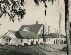
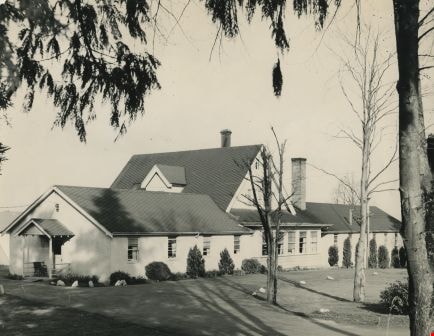
- Scope and Content
- Photograph of the exterior of the Dania Home at 4279 Norland Avenue and Canada Way. The accompanying description reads, "Dania - Modern Danish Rest Home / On site pioneer estate of C.F. Sprott, one of first reeves of Burnaby, Douglas Road - near Norland." The original house, at the centre of the b…
- Repository
- City of Burnaby Archives
- Date
- 1958
- Collection/Fonds
- Burnaby Historical Society fonds
- Subseries
- Photographs subseries
- Physical Description
- 1 photograph : b&w ; 17.8 x 22.7 cm
- Description Level
- Item
- Record No.
- 059-001
- Access Restriction
- No restrictions
- Reproduction Restriction
- Reproduce for fair dealing purposes only
- Accession Number
- BHS2007-04
- Scope and Content
- Photograph of the exterior of the Dania Home at 4279 Norland Avenue and Canada Way. The accompanying description reads, "Dania - Modern Danish Rest Home / On site pioneer estate of C.F. Sprott, one of first reeves of Burnaby, Douglas Road - near Norland." The original house, at the centre of the building, was one of the earliest homes in the Burnaby Lake area, built in 1891 by Charles F. Sprott with the assistance of Bernard R. Hill.
- Names
- Dania Home
- Media Type
- Photograph
- Notes
- Title based on contents of photograph
- Geographic Access
- Norland Avenue
- Street Address
- 4279 Norland Avenue
- Historic Neighbourhood
- Burnaby Lake (Historic Neighbourhood)
- Planning Study Area
- Douglas-Gilpin Area
Images

Pioneer tales of Burnaby
https://search.heritageburnaby.ca/link/museumlibrary5860
- Repository
- Burnaby Village Museum
- Collection
- Digital Reference Collection
- Reference Collection
- Material Type
- Book
- ISBN
- 096928280x
- Call Number
- 971.133 SON COPY 4
- Contributor
- Sone, Michael
- Place of Publication
- Burnaby, B.C.
- Publisher
- Corporation of the District of Burnaby
- Publication Date
- c1987
- Physical Description
- 495 p. : ill. ; 31 cm.
- Inscription
- "TR687 - Bryburgh" / handprinted in pencil on frontend page
- Library Subject (LOC)
- Pioneers--British Columbia--Burnaby
- Frontier and pioneer life
- Biography
- Object History
- Early Burnaby as recalled by the settlers themselves who arrived from every corner of the world between 1888 and 1930, some witnessing incorporation of the district in 1892, all seeking a better life for themselves and especially for their children, all helping transform the wilderness into the modern municipality of today.
- Notes
- "Editor Michael Sone".
- Includes index.
- 4 copies held: copy 4
Images

Digital Books

Rooted : Chinese Canadian stories in Burnaby
https://search.heritageburnaby.ca/link/museumlibrary7646
- Repository
- Burnaby Village Museum
- Publication Date
- 2023
- Call Number
- 971.133 ROO
64 Growing Burnaby
Douglas Road Farm
�65
耕耘本拿比
local cannery. He also operated a piggery at the
farm. He maintained a healthy lifestyle for his family
and achieved success in his farming career. My
grandparents’ diligence and hard work contributed
to the prosperity of ensuing generations.
After my
- Repository
- Burnaby Village Museum
- Collection
- Digital Reference Collection
- Material Type
- Digital Resource
- ISBN
- 978-0-9689849-2-5
- Call Number
- 971.133 ROO
- Contributor
- Fong, Denise
- Lemke, Jane
- Codd, Lisa
- Place of Publication
- Burnaby
- Publisher
- City of Burnaby
- Publication Date
- 2023
- Printer
- Metropolitan Fine Printers
- Physical Description
- 203 p. : ill. ; 30.5 cm
- Library Subject (LOC)
- Chinese Canadians--British Columbia--Burnaby--History
- Race discrimination -- Canada
- Subjects
- Persons - Chinese Canadians
- Agriculture
- Agriculture - Farms
- Persons - Families
- Rights
- Rights - Human Rights
- Social Issues
- Social Issues - Racism
- Notes
- There are two versions of the book: English and Simplified Chinese (left, below) and the other in English and Traditional Chinese (right, below).
- From the late 1800s to the present day, Chinese Canadians have made Burnaby into a more vibrant and livable city. Rooted: Chinese Canadian Stories in Burnaby brings together a collection of diverse stories and photographs from the community, celebrating the legacy and contributions of Burnaby’s Chinese Canadian community spanning over a century. This coffee-table book features oral histories and interviews with descendants of multigenerational family farms, green grocers, corner stores, restaurants, and places of worship. Also included are archival research and community perspectives on anti-Asian racism, community activism, courage, and resilience.
- The publication has been timed to coincide with the 100th anniversary of the introduction of the Chinese Exclusion Act by the Government of Canada in 1923. This federal legislation followed decades of discriminatory legislation by Canada’s federal, provincial and municipal governments that targeted Chinese Canadians by limiting opportunities to live, work and raise families in Canada. The Chinese Exclusion Act banned almost all migration from China and remained in place until 1947. Publishing this book in 2023 is an effort by the City of Burnaby to recognize the impact of discriminatory legislation on Chinese Canadians in our community, including discriminatory bylaws and practices implemented by Burnaby’s early municipal government.
- Edited by Denise Fong (Lead Researcher), Jane Lemke (Burnaby Village Museum Curator) and Lisa Codd (City of Burnaby Heritage Planner).
Images
