Narrow Results By
Subject
- Advertising Medium 1
- Advertising Medium - Signs and Signboards 6
- Aerial Photographs 11
- Agriculture 1
- Agriculture - Farms 2
- Animals - Dogs 6
- Armament - Munitions 1
- Buildings 2
- Buildings - Civic - Archives 1
- Buildings - Civic - City Halls 1
- Buildings - Civic - Fire Halls 2
- Buildings - Civic - Hospitals 3
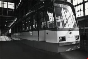
Siemens Track Vehicle
https://search.heritageburnaby.ca/link/archivedescription79399
- Repository
- City of Burnaby Archives
- Date
- October, 1976
- Collection/Fonds
- Burnaby Public Library Contemporary Visual Archive Project
- Description Level
- Item
- Physical Description
- 1 photograph : b&w ; 11 x 16 cm mounted on cardboard
- Scope and Content
- Photograph shows Siemens track vehicle stored in the old Dominion Bridge building at the corner of Boundary Road and Lougheed Highway. According to the photographer, this vehicle was bought by BC Hydro under the NDP government (1972-1975) to initiate rapid transit but it was never used partly beca…
- Repository
- City of Burnaby Archives
- Date
- October, 1976
- Collection/Fonds
- Burnaby Public Library Contemporary Visual Archive Project
- Physical Description
- 1 photograph : b&w ; 11 x 16 cm mounted on cardboard
- Description Level
- Item
- Record No.
- 556-275
- Access Restriction
- No restrictions
- Reproduction Restriction
- Reproduce for fair dealing purposes only
- Accession Number
- 2013-13
- Scope and Content
- Photograph shows Siemens track vehicle stored in the old Dominion Bridge building at the corner of Boundary Road and Lougheed Highway. According to the photographer, this vehicle was bought by BC Hydro under the NDP government (1972-1975) to initiate rapid transit but it was never used partly because of the wrong gauge on existing rail lines.
- Subjects
- Transportation - Electric Railroads
- Media Type
- Photograph
- Photographer
- Cook, Alan
- Notes
- Scope note taken directly from BPL photograph description.
- 1 b&w copy negative : 10 x 12.5 cm accompanying
- Geographic Access
- Henning Drive
- Street Address
- 3880 Henning Drive
- Historic Neighbourhood
- Broadview (Historic Neighbourhood)
- Planning Study Area
- West Central Valley Area
Images


Sieves with Chinese characters
https://search.heritageburnaby.ca/link/museumdescription9525
- Repository
- Burnaby Village Museum
- Date
- 1975
- Collection/Fonds
- Way Sang Yuen Wat Kee & Co. fonds
- Description Level
- Item
- Physical Description
- 1 photograph : col. ; 9.9 x 13.6 cm
- Scope and Content
- Photograph of four round wooden sieves on wooden counter inside Way Sang Yuen Wat Kee & Co., 1620 Government Street, Victoria. Two sieves in foreground have Chinese characters. Large wood cabinet with drawers is visible behind.
- Repository
- Burnaby Village Museum
- Collection/Fonds
- Way Sang Yuen Wat Kee & Co. fonds
- Description Level
- Item
- Physical Description
- 1 photograph : col. ; 9.9 x 13.6 cm
- Material Details
- "19" written on front right corner in black ink.
- Scope and Content
- Photograph of four round wooden sieves on wooden counter inside Way Sang Yuen Wat Kee & Co., 1620 Government Street, Victoria. Two sieves in foreground have Chinese characters. Large wood cabinet with drawers is visible behind.
- Accession Code
- BV017.7.335
- Access Restriction
- No restrictions
- Reproduction Restriction
- No known restrictions
- Date
- 1975
- Media Type
- Photograph
- Scan Resolution
- 600
- Scan Date
- 20-Aug-2018
- Notes
- Title based on contents of photograph
Images

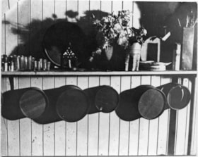
Sifters Hanging on a Wall
https://search.heritageburnaby.ca/link/museumdescription9530
- Repository
- Burnaby Village Museum
- Date
- 1975
- Collection/Fonds
- Way Sang Yuen Wat Kee & Co. fonds
- Description Level
- Item
- Physical Description
- 1 photograph : b&w ; 9.5 cm x 12 cm
- Scope and Content
- Photograph of shelf along wall inside Way Sang Yuen Wat Kee & Co., 1620 Government Street, Victoria. Five sifters in various sizes are hanging on a wall underneath of shelf. On top of the shelf, from left to right, sits several kinds of different sized glasses, another sifter leaning against the wa…
- Repository
- Burnaby Village Museum
- Collection/Fonds
- Way Sang Yuen Wat Kee & Co. fonds
- Description Level
- Item
- Physical Description
- 1 photograph : b&w ; 9.5 cm x 12 cm
- Scope and Content
- Photograph of shelf along wall inside Way Sang Yuen Wat Kee & Co., 1620 Government Street, Victoria. Five sifters in various sizes are hanging on a wall underneath of shelf. On top of the shelf, from left to right, sits several kinds of different sized glasses, another sifter leaning against the wall, two vases with flowers, a fluted, printed bowl or dish, a spray can and a tall vase with branches or twigs in it.
- Accession Code
- BV017.7.340
- Access Restriction
- No restrictions
- Reproduction Restriction
- No known restrictions
- Date
- 1975
- Media Type
- Photograph
- Scan Resolution
- 600
- Scan Date
- 3-Jul-2018
- Notes
- Title based on contents of photograph
Images

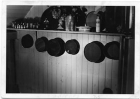
Sifters hanging on a wall
https://search.heritageburnaby.ca/link/museumdescription9540
- Repository
- Burnaby Village Museum
- Date
- 1975
- Collection/Fonds
- Way Sang Yuen Wat Kee & Co. fonds
- Description Level
- Item
- Physical Description
- 1 photograph : b&w ; 9 cm x 12.5 cm
- Scope and Content
- Photograph of shelf on wall inside Way Sang Yuen Wat Kee & Co., 1620 Government Street, Victoria. Sifters are hanging on wall beneath the shelf. The sifters are in varying sizes in a dark colour. On top of the shelf, from left to right, sits several kinds of different sized glasses, another sifter …
- Repository
- Burnaby Village Museum
- Collection/Fonds
- Way Sang Yuen Wat Kee & Co. fonds
- Description Level
- Item
- Physical Description
- 1 photograph : b&w ; 9 cm x 12.5 cm
- Material Details
- On the lower front border of the photograph, the number "25" and "SIEVES" are written with a fine, purple felt marker. The back side of the photograph have a lightly, stamped set of numbers "035[..]1" and "10.5.[..]"
- Scope and Content
- Photograph of shelf on wall inside Way Sang Yuen Wat Kee & Co., 1620 Government Street, Victoria. Sifters are hanging on wall beneath the shelf. The sifters are in varying sizes in a dark colour. On top of the shelf, from left to right, sits several kinds of different sized glasses, another sifter leaning against the wall, two vases with flowers, a fluted, printed bowl or dish, a spray can of "Glade" and a tall vase with branches or twigs in it.
- Accession Code
- BV017.7.350
- Access Restriction
- No restrictions
- Reproduction Restriction
- No known restrictions
- Date
- 1975
- Media Type
- Photograph
- Scan Resolution
- 600
- Scan Date
- 3-Jul-2018
- Notes
- Title based on contents of photograph
- This photograph is another angle view of the photograph BV017.7.340.
Images

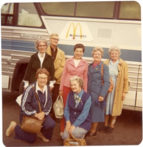
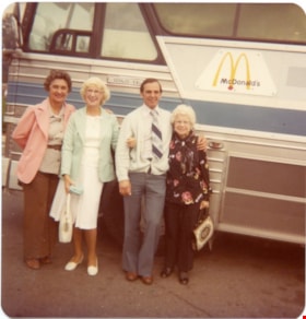
Six women and a man standing in front of a bus.
https://search.heritageburnaby.ca/link/museumdescription5030
- Repository
- Burnaby Village Museum
- Date
- 1970-1980
- Collection/Fonds
- Burnaby Village Museum Photograph collection
- Description Level
- Item
- Physical Description
- 1 photograph : coloured ; 9 x 8.5 cm
- Scope and Content
- Six women and one man in front of a bus. Two of the women are kneeling in front. The bus has a McDonald's sign on it.
- Repository
- Burnaby Village Museum
- Collection/Fonds
- Burnaby Village Museum Photograph collection
- Description Level
- Item
- Physical Description
- 1 photograph : coloured ; 9 x 8.5 cm
- Scope and Content
- Six women and one man in front of a bus. Two of the women are kneeling in front. The bus has a McDonald's sign on it.
- History
- Mrs Bate was a church choir singer. In 1976 she was asked to help form the Confederation Singers at the North Burnaby Confederation Seniors Centre. She started the choir and conducted it until her retirement in 1986. The costume, as seen in several photographs and also in the Burnaby Vilalge Museum collection, was made by members of the choir who made similar 1890's period costumes for themselves. The choir sang in seniors centres and at special events at Century Park (now known as the Burnaby Village Museum). They were also invited to sing at Government House in Victoria.
- Other Title Information
- Title based on contents of photograph
- Accession Code
- BV010.8.60
- Access Restriction
- No restrictions
- Date
- 1970-1980
- Media Type
- Photograph
- Scan Resolution
- 600
- Scan Date
- 22-05-2018
Images

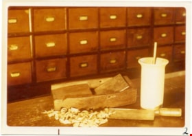
Slicer on counter at Way Sang Yuen Wat Kee & Co.
https://search.heritageburnaby.ca/link/museumdescription9480
- Repository
- Burnaby Village Museum
- Date
- 1975
- Collection/Fonds
- Way Sang Yuen Wat Kee & Co. fonds
- Description Level
- Item
- Physical Description
- 1 photograph : col. ; 9 x 12.5 cm
- Scope and Content
- Photograph of a wooden counter with a small wooden slicer for shaving meteria medica inside Way Sang Yuen Wat Kee & Co., 1620 Government Street, Victoria. There are some shavings in front and also there is a large rectangular chopping knife. There is also a tall mortrar and pestle next to the slice…
- Repository
- Burnaby Village Museum
- Collection/Fonds
- Way Sang Yuen Wat Kee & Co. fonds
- Description Level
- Item
- Physical Description
- 1 photograph : col. ; 9 x 12.5 cm
- Material Details
- " 2 on the front of the photo with felt pen "
- Scope and Content
- Photograph of a wooden counter with a small wooden slicer for shaving meteria medica inside Way Sang Yuen Wat Kee & Co., 1620 Government Street, Victoria. There are some shavings in front and also there is a large rectangular chopping knife. There is also a tall mortrar and pestle next to the slicer. In the background are rows of wooden drawers.
- Accession Code
- BV017.7.290
- Access Restriction
- No restrictions
- Reproduction Restriction
- No known restrictions
- Date
- 1975
- Media Type
- Photograph
- Scan Resolution
- 600
- Scan Date
- 29-Jul-2018
- Scale
- 96
- Notes
- Title based on contents of photograph
Images

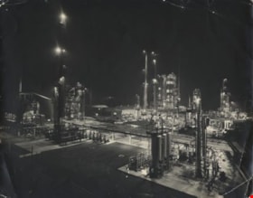
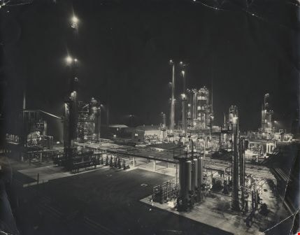
Standard Oil Stanovan Refinery
https://search.heritageburnaby.ca/link/archivedescription34566
- Repository
- City of Burnaby Archives
- Date
- 1958
- Collection/Fonds
- Burnaby Historical Society fonds
- Description Level
- Item
- Physical Description
- 1 photograph : b&w ; 27.8 x 35.3 cm
- Scope and Content
- Photograph of the Standard Oil Company Stanovan Refinery process area, Burrard Inlet. The area is lit up at night. Photograph of the Standard Oil Refinery at night. After the government broke up Standard Oil in 1911, its West Coast operations became the Standard Oil of California (SoCal), owning t…
- Repository
- City of Burnaby Archives
- Date
- 1958
- Collection/Fonds
- Burnaby Historical Society fonds
- Subseries
- Photographs subseries
- Physical Description
- 1 photograph : b&w ; 27.8 x 35.3 cm
- Description Level
- Item
- Record No.
- 052-002
- Access Restriction
- No restrictions
- Reproduction Restriction
- Reproduce for fair dealing purposes only
- Accession Number
- BHS2007-04
- Scope and Content
- Photograph of the Standard Oil Company Stanovan Refinery process area, Burrard Inlet. The area is lit up at night. Photograph of the Standard Oil Refinery at night. After the government broke up Standard Oil in 1911, its West Coast operations became the Standard Oil of California (SoCal), owning the Standard Oil Company of British Columbia Ltd, and adopting the name Chevron in the 1970's.
- Subjects
- Buildings - Industrial - Refineries
- Media Type
- Photograph
- Photographer
- Industrial Photographers
- Notes
- Title based on contents of photograph
- Geographic Access
- Eton Street
- Street Address
- 4403 Eton Street
- Historic Neighbourhood
- Vancouver Heights (Historic Neighbourhood)
- Planning Study Area
- Burnaby Heights Area
Images
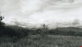
Still Creek
https://search.heritageburnaby.ca/link/archivedescription36510
- Repository
- City of Burnaby Archives
- Date
- 1950
- Collection/Fonds
- Burnaby Historical Society fonds
- Description Level
- Item
- Physical Description
- 1 photograph : b&w ; 8.5 x 14 cm
- Scope and Content
- Photograph of the Burnaby Lake bog taken from a small board walk that connected Sperling Avenue with a trail to Government Road at the west end of Burnaby Lake. Near the modern-day site of the Burnaby Lake Sports fields, this photograph was taken looking north west across Sperling Avenue and Still …
- Repository
- City of Burnaby Archives
- Date
- 1950
- Collection/Fonds
- Burnaby Historical Society fonds
- Subseries
- Photographs subseries
- Physical Description
- 1 photograph : b&w ; 8.5 x 14 cm
- Description Level
- Item
- Record No.
- 288-001
- Access Restriction
- No restrictions
- Reproduction Restriction
- Reproduce for fair dealing purposes only
- Accession Number
- BHS1992-23
- Scope and Content
- Photograph of the Burnaby Lake bog taken from a small board walk that connected Sperling Avenue with a trail to Government Road at the west end of Burnaby Lake. Near the modern-day site of the Burnaby Lake Sports fields, this photograph was taken looking north west across Sperling Avenue and Still Creek.
- Subjects
- Geographic Features - Bogs
- Names
- Still Creek
- Media Type
- Photograph
- Notes
- Title based on contents of photograph
- Photograph is a modern contact print of an original negative that was loaned to the Archives
- Geographic Access
- Still Creek
- Burnaby Lake
- Sperling Avenue
- Historic Neighbourhood
- Burnaby Lake (Historic Neighbourhood)
- Planning Study Area
- Douglas-Gilpin Area
Images

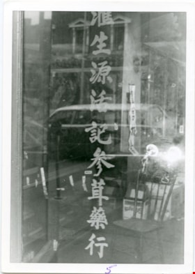
Store front door of Way Sang Yuen Wat Kee & Co
https://search.heritageburnaby.ca/link/museumdescription9422
- Repository
- Burnaby Village Museum
- Date
- 1975
- Collection/Fonds
- Way Sang Yuen Wat Kee & Co. fonds
- Description Level
- Item
- Physical Description
- 1 photograph : b&w ; 8.5 x 12.5 cm
- Scope and Content
- Photograph of the front door of Way Sang Yuen Wat Kee & Co., 1620 Government Street, Victoria. Photograph is taken from the inside looking out to the street beyond. The door has Chinese characters painted down the middle of the glass. There are two smaller windows on either side of the door. To the…
- Repository
- Burnaby Village Museum
- Collection/Fonds
- Way Sang Yuen Wat Kee & Co. fonds
- Description Level
- Item
- Physical Description
- 1 photograph : b&w ; 8.5 x 12.5 cm
- Material Details
- " 11 on the front of photo with felt pen "
- Scope and Content
- Photograph of the front door of Way Sang Yuen Wat Kee & Co., 1620 Government Street, Victoria. Photograph is taken from the inside looking out to the street beyond. The door has Chinese characters painted down the middle of the glass. There are two smaller windows on either side of the door. To the right of the door you can see some containers on a shelf.
- Geographic Access
- Victoria
- Accession Code
- BV017.7.232
- Access Restriction
- No restrictions
- Reproduction Restriction
- No known restrictions
- Date
- 1975
- Media Type
- Photograph
- Scan Resolution
- 600
- Scan Date
- 29-Jul-2018
- Scale
- 96
- Notes
- Title based on contents of photograph
Images

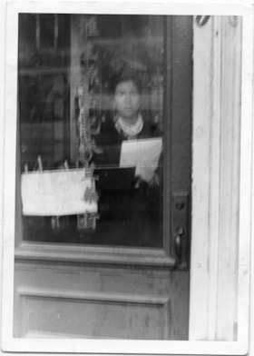
Store front door of Way Sang Yuen Wat Kee & Co
https://search.heritageburnaby.ca/link/museumdescription9424
- Repository
- Burnaby Village Museum
- Date
- 1975
- Collection/Fonds
- Way Sang Yuen Wat Kee & Co. fonds
- Description Level
- Item
- Physical Description
- 1 photograph : b&w ; 12.5 x 8.5 cm
- Scope and Content
- Photograph of person standing inside the front door of Way Sang Yuen Wat Kee & Co., 1620 Government Street. Photograph is taken from the outside looking in. There are Chinese characters down the middle of the glass door. An unidentified Chinese woman is standing inside the store. There are pieces o…
- Repository
- Burnaby Village Museum
- Collection/Fonds
- Way Sang Yuen Wat Kee & Co. fonds
- Description Level
- Item
- Physical Description
- 1 photograph : b&w ; 12.5 x 8.5 cm
- Scope and Content
- Photograph of person standing inside the front door of Way Sang Yuen Wat Kee & Co., 1620 Government Street. Photograph is taken from the outside looking in. There are Chinese characters down the middle of the glass door. An unidentified Chinese woman is standing inside the store. There are pieces of paper on a string held on by cloths pegs across the door on the inside.
- Geographic Access
- Victoria
- Accession Code
- BV017.7.234
- Access Restriction
- No restrictions
- Reproduction Restriction
- May be restricted by third party rights
- Date
- 1975
- Media Type
- Photograph
- Scan Resolution
- 600
- Scan Date
- 29-Jul-2018
- Scale
- 96
- Notes
- Title based on contents of photograph
Images

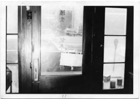
Store front window of Way Sang Yuen Wat Kee & Co
https://search.heritageburnaby.ca/link/museumdescription9421
- Repository
- Burnaby Village Museum
- Date
- 1975
- Collection/Fonds
- Way Sang Yuen Wat Kee & Co. fonds
- Description Level
- Item
- Physical Description
- 1 photograph : b&w ; 12.5 x 8.5 cm
- Scope and Content
- Photograph of front door window-frame looking through to the interior of of Way Sang Yuen Wat Kee & Co., 1620 Government Street, Victoria. There are Chinese characters going down the middle of the window. On the inside you can see a chair, some boxes and some shelves along the wall.
- Repository
- Burnaby Village Museum
- Collection/Fonds
- Way Sang Yuen Wat Kee & Co. fonds
- Description Level
- Item
- Physical Description
- 1 photograph : b&w ; 12.5 x 8.5 cm
- Material Details
- " 5 on the front of photo with felt pen."
- Scope and Content
- Photograph of front door window-frame looking through to the interior of of Way Sang Yuen Wat Kee & Co., 1620 Government Street, Victoria. There are Chinese characters going down the middle of the window. On the inside you can see a chair, some boxes and some shelves along the wall.
- Geographic Access
- Victoria
- Accession Code
- BV017.7.231
- Access Restriction
- No restrictions
- Reproduction Restriction
- No known restrictions
- Date
- 1975
- Media Type
- Photograph
- Scan Resolution
- 600
- Scan Date
- 29-Jul-2018
- Scale
- 96
- Notes
- Title based on contents of photograph
Images

Stride family subseries
https://search.heritageburnaby.ca/link/archivedescription65848
- Repository
- City of Burnaby Archives
- Date
- 1900-1926
- Collection/Fonds
- Burnaby Historical Society fonds
- Description Level
- Subseries
- Physical Description
- Textual records and photographs
- Scope and Content
- Subseries consists of photographs and government records pertaining to the Stride family of Burnaby, including a tax demand and the booklet version of by-law no. 509.
- Repository
- City of Burnaby Archives
- Date
- 1900-1926
- Collection/Fonds
- Burnaby Historical Society fonds
- Subseries
- Stride family subseries
- Physical Description
- Textual records and photographs
- Description Level
- Subseries
- Accession Number
- BHS2007-04
- Scope and Content
- Subseries consists of photographs and government records pertaining to the Stride family of Burnaby, including a tax demand and the booklet version of by-law no. 509.
- History
- Eber Stride was born in Somerset England, one of three brothers, along with Albert and Sydney. Older brother Sydney came to Canada with Eber and Eber’s wife Mary in 1888 and settled in New Westminster. Both bricklayers by trade, Sydney soon began operating the brickyard at Queen’s Park. Mary McKinnon was born in Dorset, England on October 1, 1857. Her father, Hugh McKinnon worked as a coast guard. Mary worked as a school teacher in Somerset for nine years before marrying Eber Stride on April 28, 1888 and relocating to Canada. Eber and Mary were living at Royal Avenue in New Westminster when their first child Charles Edgar was born on February 24, 1890. Their second child, Edwin Hubert was born November 26, 1892. In May of 1893 the family of four moved to Burnaby. Their third child, Marguerite "Margaret" Ella, was born in Burnaby on April 2, 1895. The Stride family owned and operated Stride and Son Florist Green houses located at their residence at 1749 Kingsway (later renumbered 7434 Kingsway). Eber joined the municipal council a year after its incorporation and served for nineteen consecutive years; from 1894-1911 and again in 1913. Eber and Mary were life-long members of the St. Alban’s Anglican Church in Burnaby, dating back to the Churchs’ beginings. The Strides are considered Edmonds district pioneers. The Stride children attended Westside School and later Royal City High School. Both sons worked for the family florist business after they left school. Edwin continued working there, applying for a chauffeur licence renewal in September of 1916 at the age of twenty-three. Edwin and Eber operated the business together for over 40 years. Charles Edgar didn’t stay a florist long. Instead, he had a brief career building houses before travelling to San Francisco by bicycle with a friend to attend the World’s Fair. He continued on to Tijuana, Mexico before heading home to join the Reserves and head overseas. Once back in New Westminster, Charles Edgar opened a series of photographic studios along Columbia Street. His first studio was Universal Photographers, operating from 1918 to 1925. He opened Brighton Studios at 657 Columbia Street as well from 1924 to 1925. In 1926 he opened Stride Studios at 657 Columbia Street, which thrived until 1968 when an unfortunate fire in a neighbouring business destroyed most of his prints and negatives. In 1928 he bought Columbia Studio across the street at 624 Columbia Street and owned it anonymously until 1960. For thirty years, no one knew that he owned both businesses and was able to send disgruntled customers “across the street to the competition.” Margaret Stride married and became Margaret Hokanson. Mary Stride died September 24, 1933 at the age of 75. Eber died November 8, 1942 at the age of 84. Edwin died April 16, 1970 at the age of 77. Charles Edgar died February 29, 1972 at the age of 82. Stride Avenue in Burnaby was named after Eber Stride.
- Media Type
- Photograph
- Textual Record
- Creator
- Stride, Charles Edgar
- Stride, Eber
- Notes
- MSS004 and PC001
- Title based on contents of subseries
![Survey and Subdivision plans in New Westminster District Group 1 and Group 2 – Vancouver, ʷməθkʷəy̓əm (Musqueam) Indian Reserve, Burnaby, Surrey
, [1910-1911] thumbnail](/media/hpo/_Data/_BVM_Cartographic_Material/1977/1977_0093_0017_001.jpg?width=280)
Survey and Subdivision plans in New Westminster District Group 1 and Group 2 – Vancouver, ʷməθkʷəy̓əm (Musqueam) Indian Reserve, Burnaby, Surrey
https://search.heritageburnaby.ca/link/museumdescription6986
- Repository
- Burnaby Village Museum
- Date
- [1910-1911]
- Collection/Fonds
- Burnaby Village Museum Map collection
- Description Level
- File
- Physical Description
- 9 plans : 4 plans : blueprint ink on paper + 4 plans : black ink on paper + 1 plan : graphite on paper mounted on 2 sides of cardboard 76 x 102 cm
- Scope and Content
- File consists of a large board of three survey plans in New Westminster District Group 1 mounted on one side and six survey and subdivision plans of District Lot 85, New Westminster District Group 1 mounted on the other side. Side A: 1. Plan : blueprint on paper ; 30.5 x 80 cm. Title reads: "Fras…
- Repository
- Burnaby Village Museum
- Collection/Fonds
- Burnaby Village Museum Map collection
- Description Level
- File
- Physical Description
- 9 plans : 4 plans : blueprint ink on paper + 4 plans : black ink on paper + 1 plan : graphite on paper mounted on 2 sides of cardboard 76 x 102 cm
- Material Details
- Scales vary (One chain equals 792 inches)
- Indexed number on tape on edge of board reads "17"
- Scope and Content
- File consists of a large board of three survey plans in New Westminster District Group 1 mounted on one side and six survey and subdivision plans of District Lot 85, New Westminster District Group 1 mounted on the other side. Side A: 1. Plan : blueprint on paper ; 30.5 x 80 cm. Title reads: "Fraser River Bridge / Plan of South Approach". Plan covers area of land north of the Fraser River and Great Northern Railway with approach for a bridge running through the "ʷməθkʷəy̓əm (Musqueam) Indian Reserve" (ʷməθkʷəy̓əm (Musqueam) First Nation) and lots marked as Dominion Government and the east half of Lot 2 identified as "C. F. Brown" "Plan 851". Plan is identified as "Plan 851 / traced / Mar. 17, 1911". (Geographic location in Vancouver) Scale: 100 feet = 1 inch, Signed by Albert J. Hill / P.L.S." 2. Plan : blueprint on paper ; 36.5 x 35 cm (no title). Includes three plans of lots on the east and west sides of North Road. Note on bottom of blueprint reads: "I.E.B. McKay Surveyor General - hereby certify / that this is a correct tracing from the field / notes of the Royal Engineers on file in the / Lands Department / E.B. McKay (signature) / Surveyor General / Victoria B.C. April 11th 1911" . Plan in top left titled "Page 11 / Vol. 1. / R.E. Notes" covers District Lots east of North Road including Lot 5, Lot 7, Lot 41, Lot 9 and Lot 107 in Coquitlam. Plan in top right corner titled "Page 17 / Vol. 1. / R.E. Notes" covers District Lots east of North Road including Lot 104, Lot 54, Lot 105, Lot 55, Lot 106, Lot 9 and Lot 107 in Coquitlam and Port Moody. Plan in lower left corner titled "Page 15 / Vol. 1 / R.E. Notes" covers District Lots west of North Road including Lot 147, Lot 148, Lot 100, Lot 15 in Burnaby. 3. Plan : blue print on paper ; 29.5 x 41.5 cm. (no formal title). Plan of the North 1/2 of Section 18. Plan covers area in the "North 1/2 of Sec.18 B.5 N RGE 1 W" and "Sec. 18 B.5 N. RGE 1 W" bordered by Section 7, Section 13, Section 17 and Section 19. Bon Accord Road runs through Sec. 18. The plan is signed by surveryor "I.H. Neville Smith... C.E.B.C.L.S. / Mar. 26th 1910" and signed by "Ludwig Pillath". (Geographic location: Surrey) Side B: 1. Plan : blueprint on paper ; 43.5 x 49.5 cm. Title reads: "Plan / of Subdivision / of a Portion / of / Lot 85 / Group One / New Westminster District. Plan covers portion of land east of Deer Lake and Pole Line Road (Sperling Avenue) and south of Hastings Road in District Lot 85 in Burnaby with section 4 and a portion of section 2 coloured in red. Plan is signed by "Albert J. Hill, B.C.L.S." Plan is initialed by: "RB" [sic] (in blue pencil crayon) Scale: 4 chains = 1 inch 2. Plaln : black black ink on linen ; 39 x 37 cm. Title reads: "L.C. Hill's Property, / Burnaby". Plan covers a triangular portion of land east of Pole Line Road (Sperling Avenue) and south of Hastings Road in District Lot 85 in Burnaby. Plan is intitaled by "RB" [sic] (in blue pencil crayon). Scale: 3 chains = 1 mile 3. Plan : graphite on paper ; 23 x 17 cm. Title reads: "Portion of Lot 85 / Gr.1". Plan covers portion of land north east of Deer Lake and west of Pole Line Road (now Sperling Avenue) in District Lot 85 in Burnaby. Plan is stamped in red ink: "Albert J. Hill, Civil Engineer". Plan is initialed by: "RB" [sic] (in blue pencil crayon). Scale: 1 chain = 1 inch 4. Plan : black ink on linen ; 16 x 19 cm. Title reads: "Lot 85". Plan covers the intersection of Pole Line Road (Sperling Avenue) and Hastings Road at the north west section of District Lot 79 and District Lot 85 in Burnaby. Plan is stamped: "A.J. Hill, Civil Engineer" with identitifed in blue pencil crayon. 5. Plan : black ink on paper ; 28.5 x 37 cm. (no formal title) Plan covers an area of land, west of Pole Line Road (Sperling Avenue) and south of Deer Lake in District Lot 85 in Burnaby. Plan is initialed by: "RB" [sic] (in blue pencil crayon) 6. Plan : black ink on paper ; 21 x 34 cm (no formal title). Plan covers an area of land, west of Pole Line Road (Sperling Avenue) and south of Deer Lake in District Lot 85 in Burnaby. Plan is initialed by: "RB" [sic] (in blue pencil crayon)
- Accession Code
- HV977.93.17
- Access Restriction
- No restrictions
- Reproduction Restriction
- No known restrictions
- Date
- [1910-1911]
- Media Type
- Cartographic Material
- Historic Neighbourhood
- Burnaby Lake (Historic Neighbourhood)
- Burquitlam (Historic Neighbourhood)
- Planning Study Area
- Morley-Buckingham Area
- Douglas-Gilpin Area
- Scan Resolution
- 600
- Scan Date
- 2023-06-26
- Notes
- Title based on contents of file
- Scale is measured in chains and feet. (One chain equals 792 inches).
- The term "Lot" also refers to a "District Lot”
- Some plans are stamped: "Albert J. Hill, Civil Engineer / and / Provincial Land Surveyor, / New Westminster, / B.C." and intialed: "RB" [sic]
Zoomable Images
![Survey and Subdivision plans in New Westminster District Group 1 and Group 2 – Vancouver, ʷməθkʷəy̓əm (Musqueam) Indian Reserve, Burnaby, Surrey
, [1910-1911] thumbnail](/media/hpo/_Data/_BVM_Cartographic_Material/1977/1977_0093_0017_003_seadragon/1977_0093_0017_003.jpg?w=280)
Survey and Subdivision plans in New Westminster District Group 1 and Group 2 – Vancouver, ʷməθkʷəy̓əm (Musqueam) Indian Reserve, Burnaby, Surrey , [1910-1911]
Zoom into Image
![Survey and Subdivision plans in New Westminster District Group 2 - Surrey, ʷməθkʷəy̓əm (Musqueam) Indian Reserve, [190-] thumbnail](/media/hpo/_Data/_BVM_Cartographic_Material/1977/1977_0093_0086_001.jpg?width=280)
Survey and Subdivision plans in New Westminster District Group 2 - Surrey, ʷməθkʷəy̓əm (Musqueam) Indian Reserve
https://search.heritageburnaby.ca/link/museumdescription7055
- Repository
- Burnaby Village Museum
- Date
- [190-]
- Collection/Fonds
- Burnaby Village Museum Map collection
- Description Level
- File
- Physical Description
- 12 plans : graphite and ink on paper and linen; various sizes mounted on 2 sides of cardboard 76 x 102 cm
- Scope and Content
- File consists of a large board with twelve plans (six plans mounted on each side). All plans are located in New Westminster District, Group 2, covering geographic areas within Surrey. Side A: 1. Plan : black ink on paper ; 20.5 x 57.5 cm. Title reads: "Extension of Tram Line / Hospital to Distill…
- Repository
- Burnaby Village Museum
- Collection/Fonds
- Burnaby Village Museum Map collection
- Description Level
- File
- Physical Description
- 12 plans : graphite and ink on paper and linen; various sizes mounted on 2 sides of cardboard 76 x 102 cm
- Scope and Content
- File consists of a large board with twelve plans (six plans mounted on each side). All plans are located in New Westminster District, Group 2, covering geographic areas within Surrey. Side A: 1. Plan : black ink on paper ; 20.5 x 57.5 cm. Title reads: "Extension of Tram Line / Hospital to Distillery St." Scales: Hor: 100 feet = 1 inch; Vert: 20 feet = 1 inch. tram line, hospital to distillery street; 2. Plan : black ink on linen ; 55 x 46.5 cm. (no title). Plan covers New Westminster District, Group 2, Lots 1,2, 3,4, A and B and the ʷməθkʷəy̓əm (Musqueam) Indian Reserve (1868).along the south shore of the Fraser River opposite City of New Westminster. Portion of land is highlighted in blue along the west border of the "ʷməθkʷəy̓əm (Musqueam) Indian Reserve" and between Lot 2 and Lot 1 and survey lines identified as "Mohun's Line" and Hill's Line. Stamp in red ink on plan reads: "Albert J. HIll, M.A. / Civil Engineer / and Provincial Land Surveyor / New Westminster / B.C." (Geographic location: Surrey also formerly known as Brownsville) 3. Plan : black ink on paper ; 34.5 x 23 cm. Title reads: "Lot 51, Gr.2" (in blue crayon). Plan covers area in New Westminster, Group 2, District Lot 51, north of Mud Bay with the Victoria Terminal Railway and Great Northern Railway lines identified. (Geographic location: Surrey) 4. Plan : graphite on paper ; 16.5 x 18 cm. Title reads: "Sec.20, B5N R2W" (underlined in blue crayon). Sketch plan covers and area in New Westmninster District, Group 2. Plan includes initials "RB" in blue crayon. Scale: 5 chains = 1 inch (Geographic location: Surrey) 5. Plan : graphite on paper with annotations in black ink ; 17 x 21 cm. Title reads: "N.W.1/4 Sec.12 TP2" (in blue crayon). Plan covers an area in New Westminster District Group 2 in Section 12, south of Bose Road. Identifying land marks include names: "Bose", "Smith" and "Church Land" Scale: 8 chains = 1 inch (Geographic location: Surrey) 6. Plan : graphite on paper ; 38 x 26.5 cm. (no title) Sketch plan covers areas in Lot 1 and Lot 2 with land identified as "Dominion Government". (could be survey for ʷməθkʷəy̓əm (Musqueam) Indian Reserve) (Geographic location: Surrey also formerly known as Brownsville) Side B: 1. Plan: black ink on paper ; 53.5 x 38 cm. Title reads:"Plan of Subdivision / of / Section 27, / Block 5 North, Range 2 West / New Westminster District". Scale: 4 chains = 1 inch. Includes area subdivided into 18 lots, south of Hjorth Road (104th Avenue) and west of Quible Road with Yale Road running through. Note in blue crayon reads: See also Bd.93) (Geographic location: Surrey) 2. Plan : black ink on paper ; 35 x 28 cm. Title reads: "Plan / of / Block A - L387A / Surrey". Scale: 2 chains = 1 inch. Annotaion in blue crayon reads: "Blk A / Lot 387a_Gr. 2". Plan covers New Westminster District Group 2, Block A, Lot 387 A, south of Parsons Slough and east of Latimer Road (192nd Street). Stamp in red ink on plan reads: "Albert J. HIll, M.A. / Civil Engineer / and Provincial Land Surveyor / New Westminster / B.C." (Geographic location: Surrey) 3. Plan : black ink on linen ; 50 x 42 cm. Title reads: Plan / of part of / Campbell River / running through / the South portion / of N.E. 1/4, Section 8, / Tp. 7, East of Coast Meridian / also / Showing location / of Shingle Mill and Dam". Scale: 100 feet = 1 inch. Plan covers the area in New Westminster District, Township 7, Section 8 with Hall's Prairie Road (184th Street) running through and intersecting with Campbell River. Vegetation, buildings, bridge, shingle mill are identified. (Geographic location: Surrey) 5. Plan : black ink on linen ; 21.5 x 16.5 cm. Title reads: "Sec.32, B5N R2W". Scale: 10 chains = 1 inch. Signed by "Albert J. Hill / B.C.L.S. / Dec. 23, 1908". Note on survey reads: "No actual survey / 40 ac. surveyed". (Geographic location: Surrey) 6. Plan : graphite on paper ; 22 x 15.5 cm. Title reads: "Position 'A5' Subjects / by _McKenzie" [Geographic location: Surrey]
- Creator
- Hill, Albert James
- Names
- ʷməθkʷəy̓əm (Musqueam)
- Accession Code
- HV977.93.86
- Access Restriction
- No restrictions
- Reproduction Restriction
- No known restrictions
- Date
- [190-]
- Media Type
- Cartographic Material
- Scan Resolution
- 600
- Scan Date
- 2023-06-26
- Notes
- Title based on contents of file
- Numeric stamp on edge of board reads: "86"
Zoomable Images
![Survey and Subdivision plans in New Westminster District Group 2 - Surrey, ʷməθkʷəy̓əm (Musqueam) Indian Reserve, [190-] thumbnail](/media/hpo/_Data/_BVM_Cartographic_Material/1977/1977_0093_0086_003_seadragon/1977_0093_0086_003.jpg?w=280)
Survey and Subdivision plans in New Westminster District Group 2 - Surrey, ʷməθkʷəy̓əm (Musqueam) Indian Reserve, [190-]
Zoom into Image
![Svend Robinson on the carousel, [between 1989 and 1999] thumbnail](/media/hpo/_Data/_BVM_Images/2015/2015_0041_0100_001.jpg?width=280)
Svend Robinson on the carousel
https://search.heritageburnaby.ca/link/museumdescription9657
- Repository
- Burnaby Village Museum
- Date
- [between 1989 and 1999]
- Collection/Fonds
- Keith Jamieson fonds
- Description Level
- Item
- Physical Description
- 1 photograph : col ; copy print ; 10.5 x 10 cm
- Scope and Content
- Svend Robinson Burnaby MP on the carousel. He is riding a white horse that is holding its head up high and wearing a brown bridle.
- Repository
- Burnaby Village Museum
- Collection/Fonds
- Keith Jamieson fonds
- Description Level
- Item
- Physical Description
- 1 photograph : col ; copy print ; 10.5 x 10 cm
- Material Details
- Printed label in scrapbook beneath photograph read: "SWEND[sic] ROBINSON (M.P.)".
- Scope and Content
- Svend Robinson Burnaby MP on the carousel. He is riding a white horse that is holding its head up high and wearing a brown bridle.
- History
- From Scrapbook vol III The Story in Photographs Continues. In 1989, Ms. Venus Solano and Mr. Doug McCalum and other local people came together to "Save the Carousel" and formed the "Friends of the Vancouver Carousel Society". In May 1989, Burnaby Village Museum agreed to provide a home for the carousel and the "Friends", led by President Don Wrigley, set about raising the $350,000 to purchase the machine. Keith Jamieson, a carousel expert, was brought in to coordinate the rebuilding project. With a lot of hard work, the help of the Government of British Columbia and the support of the Municipality of Burnaby, the carousel was purchased. Funds were also raised to pay for the restoration, and Burnaby agreed to build a new pavilion for it as a Centennial project.
- Other Title Information
- title based on contents of photograph
- Subjects
- Recreational Devices - Carousels
- Names
- Lower Mainland Association of the Friends of the Vancouver Carousel
- Jamieson, Keith
- Jamieson, Pat
- Pacific National Exhibition (PNE)
- C.W. Parker no. 119 Carousel
- Accession Code
- BV015.41.100
- Date
- [between 1989 and 1999]
- Media Type
- Photograph
- Scan Resolution
- 600
- Scan Date
- 17-Sep-18
- Notes
- The photograph was removed from the scrapbook titled, "Parker Carousel Volume III- The Story in Photographs Continues" (BV015.41.3) . The scrapbook is a photograph album providing a detailed account regarding the restoration (before and after) and reassembly of the Parker #119 carousel.
Images
![Svend Robinson on the carousel, [between 1989 and 1999] thumbnail](/media/hpo/_Data/_BVM_Images/2015/2015_0041_0100_001.jpg)
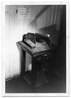
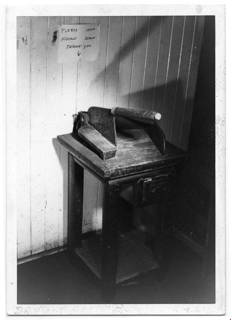
The Table Top chopper
https://search.heritageburnaby.ca/link/museumdescription9535
- Repository
- Burnaby Village Museum
- Date
- 1975
- Collection/Fonds
- Way Sang Yuen Wat Kee & Co. fonds
- Description Level
- Item
- Physical Description
- 1 photograph : b&w ; 12.5 cm x 9 cm
- Scope and Content
- Photograph of a table top chopper or medicine trimmer on a table with a small front drawer inside Way Sang Yuen Wat Kee & Co., 1620 Government Street, Victoria. Large cleaver is screwed at the top to hold it down on the table. It has a wooden handle with a side guide or stopper on the left side. …
- Repository
- Burnaby Village Museum
- Collection/Fonds
- Way Sang Yuen Wat Kee & Co. fonds
- Description Level
- Item
- Physical Description
- 1 photograph : b&w ; 12.5 cm x 9 cm
- Material Details
- On the lower front border of the photograph, the word "DRUG […]" and the number "26" is written with a faded, fine, purple felt marker. The back side of the photograph have a lightly, stamped set of numbers "03[…]]1" and "10.5.7[…]".
- Scope and Content
- Photograph of a table top chopper or medicine trimmer on a table with a small front drawer inside Way Sang Yuen Wat Kee & Co., 1620 Government Street, Victoria. Large cleaver is screwed at the top to hold it down on the table. It has a wooden handle with a side guide or stopper on the left side. Above the item is a handwritten sign all in caps taped to the wall, "PLEASE LEAVE HANDLE DOWN THANK YOU."
- Accession Code
- BV017.7.345
- Access Restriction
- No restrictions
- Reproduction Restriction
- No known restrictions
- Date
- 1975
- Media Type
- Photograph
- Scan Resolution
- 600
- Scan Date
- 3-Jul-2018
- Notes
- Title based on contents of photograph
- This photograph is an itemized copy of the items in photograph BV017.7.341.
Images
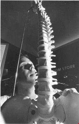
Taki Galonopoulos
https://search.heritageburnaby.ca/link/archivedescription78662
- Repository
- City of Burnaby Archives
- Date
- October 22, 1995
- Collection/Fonds
- Burnaby NewsLeader photograph collection
- Description Level
- Item
- Physical Description
- 1 photograph : b&w ; 23.5 x 15 cm
- Scope and Content
- Photograph of Taki Galonopoulos, a fourth year kinesiology student at Simon Fraser University examining a model of a human spine while visiting the Science and Technology Showcase at Metrotown. The event was sponsored by the City of Burnaby, Simon Fraser University and the provincial government.
- Repository
- City of Burnaby Archives
- Date
- October 22, 1995
- Collection/Fonds
- Burnaby NewsLeader photograph collection
- Physical Description
- 1 photograph : b&w ; 23.5 x 15 cm
- Description Level
- Item
- Record No.
- 535-0023
- Access Restriction
- No restrictions
- Reproduction Restriction
- No reproduction permitted
- Accession Number
- 2012-11
- Scope and Content
- Photograph of Taki Galonopoulos, a fourth year kinesiology student at Simon Fraser University examining a model of a human spine while visiting the Science and Technology Showcase at Metrotown. The event was sponsored by the City of Burnaby, Simon Fraser University and the provincial government.
- Names
- Galonopoulos, Taki
- Media Type
- Photograph
- Photographer
- Bartel, Mario
- Notes
- Title based on contents of photograph
- Note in black and blue ink on recto of photograph reads: "2841 A Mario Bby / 10/22 BNW p. 15 80%"
- Trim marks and/or reproduction instructions on recto (scan is cropped)
- Geographic Access
- Kingsway
Images
Thorndike series of junior high school mathematics book two, grade VIII
https://search.heritageburnaby.ca/link/museumlibrary5566
- Repository
- Burnaby Village Museum
- Collection
- Special Collection
- Material Type
- Book
- Accession Code
- HV978.48.8
- Call Number
- 510 THO
- Place of Publication
- Victoria, B.C
- Publisher
- Government of the Province of British Columbia
- Publication Date
- 1929
- Series
- Thorndike Series
- Printer
- Charles F. Banfield
- Physical Description
- v-xii, 198 p. ill, diagrs, includes index
- Inscription
- "Maud Stanley" [black ink handwritten notes inside front and back] [Various arithmetic pencilled notations throughout]
- Library Subject (LOC)
- Mathematics--Textbooks
Three women and a man in front of a bus.
https://search.heritageburnaby.ca/link/museumdescription5031
- Repository
- Burnaby Village Museum
- Date
- 1970-1980
- Collection/Fonds
- Burnaby Village Museum Photograph collection
- Description Level
- Item
- Physical Description
- 1 photograph : coloured ; 9 x 8.5 cm
- Scope and Content
- Three women and a man standing in front of a bus. The is a McDonald's sign on the bus.
- Repository
- Burnaby Village Museum
- Collection/Fonds
- Burnaby Village Museum Photograph collection
- Description Level
- Item
- Physical Description
- 1 photograph : coloured ; 9 x 8.5 cm
- Scope and Content
- Three women and a man standing in front of a bus. The is a McDonald's sign on the bus.
- History
- Mrs Bate was a church choir singer. In 1976 she was asked to help form the Confederation Singers at the North Burnaby Confederation Seniors Centre. She started the choir and conducted it until her retirement in 1986. The costume, as seen in several photographs and also in the Burnaby Vilalge Museum collection, was made by members of the choir who made similar 1890's period costumes for themselves. The choir sang in seniors centres and at special events at Century Park (now known as the Burnaby Village Museum). They were also invited to sing at Government House in Victoria.
- Other Title Information
- Title based on contents of photograph
- Accession Code
- BV010.8.61
- Access Restriction
- No restrictions
- Date
- 1970-1980
- Media Type
- Photograph
- Scan Resolution
- 600
- Scan Date
- 22-05-2018
Images

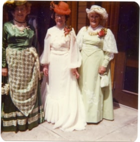
Three women in 1890's costumes.
https://search.heritageburnaby.ca/link/museumdescription5011
- Repository
- Burnaby Village Museum
- Date
- 1970-1980
- Collection/Fonds
- Burnaby Village Museum Photograph collection
- Description Level
- Item
- Physical Description
- 1 photograph : colour ; 9 x 8.5 cm
- Scope and Content
- Three women standing in front of a doorway in 1890's costumes. The one on the left is wearing a green satin dress with a patterned, coloured apron. There is light trim at the bottom of her dress. The lady in the middle is in a white dress, red hat and has a red corsage. The lady on the right is in …
- Repository
- Burnaby Village Museum
- Collection/Fonds
- Burnaby Village Museum Photograph collection
- Description Level
- Item
- Physical Description
- 1 photograph : colour ; 9 x 8.5 cm
- Scope and Content
- Three women standing in front of a doorway in 1890's costumes. The one on the left is wearing a green satin dress with a patterned, coloured apron. There is light trim at the bottom of her dress. The lady in the middle is in a white dress, red hat and has a red corsage. The lady on the right is in a light green dress with white lace at the shoulders. She has a red corsage and is wearing a white hat with green trim and is holding a small green handbag.
- History
- Mrs Bate was a church choir singer. In 1976 she was asked to help form the Confederation Singers at the North Burnaby Confederation Seniors Centre. She started the choir and conducted it until her retirement in 1986. The costume, as seen in several photographs and also in the Burnaby Vilalge Museum collection, was made by members of the choir who made similar 1890's period costumes for themselves. The choir sang in seniors centres and at special events at Century Park (now known as the Burnaby Village Museum). They were also invited to sing at Government House in Victoria.
- Other Title Information
- Title based on contents of photograph
- Accession Code
- BV010.8.41
- Access Restriction
- No restrictions
- Date
- 1970-1980
- Media Type
- Photograph
- Scan Resolution
- 600
- Scan Date
- 22-05-2018
Images
