Narrow Results By
Person / Organization
- Army, Navy and Air Force Veterans in Canada, Pompier Unit #314 1
- Baker, Ronald J. "Ron" 2
- Bossort, Kathy 2
- Damer, Eric 1
- Hagen, Judith "Judy" Robins 1
- McTaggart-Cowan, Patrick D. 1
- Royal Oak Funeral Chapel 1
- Simon Fraser University 2
- UniverCity 1
- University of British Columbia 1
- University of PEI. 1
Moving of Eight Pan-Abode Structures
https://search.heritageburnaby.ca/link/councilreport13728
- Repository
- City of Burnaby Archives
- Report ID
- 9355
- Meeting Date
- 11-Jul-1988
- Format
- Council - Manager's Report
- Manager's Report No.
- 47
- Item No.
- 12
- Collection/Fonds
- City Council and Office of the City Clerk fonds
- Repository
- City of Burnaby Archives
- Report ID
- 9355
- Meeting Date
- 11-Jul-1988
- Format
- Council - Manager's Report
- Manager's Report No.
- 47
- Item No.
- 12
- Collection/Fonds
- City Council and Office of the City Clerk fonds
Documents

South Burnaby Cenotaph
https://search.heritageburnaby.ca/link/landmark860
- Repository
- Burnaby Heritage Planning
- Description
- The South Burnaby Cenotaph is located in Bonsor Park at the corner of Nelson Avenue and Imperial Street. The cenotaph commemorates those lost in the First World War, Second World War and the Korean War.
- Associated Dates
- 1988
- Other Names
- Bonsor Park Cenotaph
- Street View URL
- Google Maps Street View
- Repository
- Burnaby Heritage Planning
- Other Names
- Bonsor Park Cenotaph
- Geographic Access
- Nelson Avenue
- Associated Dates
- 1988
- Description
- The South Burnaby Cenotaph is located in Bonsor Park at the corner of Nelson Avenue and Imperial Street. The cenotaph commemorates those lost in the First World War, Second World War and the Korean War.
- Historic Neighbourhood
- Central Park (Historic Neighbourhood)
- Planning Study Area
- Marlborough Area
- Community
- Burnaby
- Cadastral Identifier
- P.I.D. No. 027-719-375
- Boundaries
- The property (Bonsor Park) is comprised of a single municipally-owned property located at 6749 Nelson Avenue.
- Area
- 3570.00
- Contributing Resource
- Landscape Feature
- Structure
- Ownership
- Public (local)
- Street Address
- 6749 Nelson Avenue
- Street View URL
- Google Maps Street View
Images


Central Park Entrance
https://search.heritageburnaby.ca/link/archivedescription34860
- Repository
- City of Burnaby Archives
- Date
- March 23, 1985
- Collection/Fonds
- Burnaby Historical Society fonds
- Description Level
- Item
- Physical Description
- 1 photograph : col. ; 8.8 x 11.3 cm
- Scope and Content
- Photograph of the Central Park entrance on Kingsway. A car can be seen exiting the park, and the tracks of the Skytrain Expo line are in the background.
- Repository
- City of Burnaby Archives
- Date
- March 23, 1985
- Collection/Fonds
- Burnaby Historical Society fonds
- Subseries
- Evelyn Salisbury subseries
- Physical Description
- 1 photograph : col. ; 8.8 x 11.3 cm
- Description Level
- Item
- Record No.
- 145-008
- Access Restriction
- No restrictions
- Reproduction Restriction
- Reproduce for fair dealing purposes only
- Accession Number
- BHS1985-15
- Scope and Content
- Photograph of the Central Park entrance on Kingsway. A car can be seen exiting the park, and the tracks of the Skytrain Expo line are in the background.
- Subjects
- Structures - Arches
- Media Type
- Photograph
- Notes
- Title based on contents of photograph
- Geographic Access
- Central Park
- Imperial Street
- Street Address
- 3883 Imperial Street
- Historic Neighbourhood
- Central Park (Historic Neighbourhood)
- Planning Study Area
- Maywood Area
Images


Central Park Entrance
https://search.heritageburnaby.ca/link/archivedescription34861
- Repository
- City of Burnaby Archives
- Date
- March 23, 1985
- Collection/Fonds
- Burnaby Historical Society fonds
- Description Level
- Item
- Physical Description
- 1 photograph : col. ; 8.8 x 11.3 cm
- Scope and Content
- Photograph of the Central Park entrance on Kingsway. The tracks of the Skytrain Expo line can be seen in the background.
- Repository
- City of Burnaby Archives
- Date
- March 23, 1985
- Collection/Fonds
- Burnaby Historical Society fonds
- Subseries
- Evelyn Salisbury subseries
- Physical Description
- 1 photograph : col. ; 8.8 x 11.3 cm
- Description Level
- Item
- Record No.
- 145-009
- Access Restriction
- No restrictions
- Reproduction Restriction
- Reproduce for fair dealing purposes only
- Accession Number
- BHS1985-15
- Scope and Content
- Photograph of the Central Park entrance on Kingsway. The tracks of the Skytrain Expo line can be seen in the background.
- Subjects
- Structures - Arches
- Media Type
- Photograph
- Notes
- Title based on contents of photograph
- Geographic Access
- Central Park
- Imperial Street
- Street Address
- 3883 Imperial Street
- Historic Neighbourhood
- Central Park (Historic Neighbourhood)
- Planning Study Area
- Maywood Area
Images


Interview with Judy Hagen by Eric Damer November 7, 2012 - Track 6
https://search.heritageburnaby.ca/link/oralhistory337
- Repository
- City of Burnaby Archives
- Date Range
- 1944-2012
- Length
- 0:12:18
- Summary
- This portion of the recording pertains to Judith "Judy" (Robins) Hagen's memories of taking dance lessons and being in Girl Guides. She tells a story of seeing the Second Narrows Bridge collapse in 1958.
- Repository
- City of Burnaby Archives
- Summary
- This portion of the recording pertains to Judith "Judy" (Robins) Hagen's memories of taking dance lessons and being in Girl Guides. She tells a story of seeing the Second Narrows Bridge collapse in 1958.
- Date Range
- 1944-2012
- Photo Info
- Judith "Judy" Robins (later Hagen) posing in a dance costume, 1949. Item no. 549-036.
- Length
- 0:12:18
- Interviewer
- Damer, Eric
- Interview Date
- November 7, 2012
- Scope and Content
- Recording is an interview with Judith "Judy" (Robins) Hagen conducted by Burnaby Village Museum employee Eric Damer, November 7, 2012. Major theme discussed: the neighbourhood of Dover Street.
- Biographical Notes
- Judy Robins (later Hagen) was born in 1941 and grew up in South Burnaby. Her paternal grandfather, a master stone mason from Devon, moved to Vancouver in 1912 to find work before bringing over the rest of the family. He bought three lots in Burnaby and in 1918 moved his family to a small house on Dover Street (formerly Paul Street). Judy’s father, Jack, married, bought one of his father’s lots and built a new home for his family. Judy attended school and church nearby, took dance and piano lessons and participated actively in Girl Guides. After high school, she attended the University of British Columbia (UBC) and then Simon Fraser University (SFU), worked for a few years and then married in 1967 before moving to Courtaney, British Columbia.
- Total Tracks
- 7
- Total Length
- 1:09:51
- Interviewee Name
- Hagen, Judith "Judy" Robins
- Interview Location
- Nanaimo Museum on Vancouver Island
- Interviewer Bio
- Eric Damer is a lifelong British Columbian born in Victoria, raised in Kamloops, and currently residing in Burnaby. After studying philosophy at the University of Victoria, he became interested in the educational forces that had shaped his own life. He completed master’s and doctoral degrees in educational studies at the University of British Columbia with a particular interest in the history of adult and higher education in the province. In 2012, Eric worked for the City of Burnaby as a field researcher and writer, conducting interviews for the City Archives and Museum Oral History Program.
- Collection/Fonds
- Community Heritage Commission Special Projects fonds
- Transcript Available
- None
- Media Type
- Sound Recording
Images

Audio Tracks
Track six of recording of interview with Judy Hagen
Track six of recording of interview with Judy Hagen
https://search.heritageburnaby.ca/media/hpo/_Data/_Archives_Oral_Histories/_Unrestricted/MSS171-011/MSS171-011_Track_6.mp3
Jubilee Arch
https://search.heritageburnaby.ca/link/archivedescription34858
- Repository
- City of Burnaby Archives
- Date
- March 7, 1985
- Collection/Fonds
- Burnaby Historical Society fonds
- Description Level
- Item
- Physical Description
- 1 photograph : col. ; 8.8 x 11.4 cm
- Scope and Content
- Photograph of the back of the Central Park Arch at Patterson Avenue and Kingsway.
- Repository
- City of Burnaby Archives
- Date
- March 7, 1985
- Collection/Fonds
- Burnaby Historical Society fonds
- Subseries
- Evelyn Salisbury subseries
- Physical Description
- 1 photograph : col. ; 8.8 x 11.4 cm
- Description Level
- Item
- Record No.
- 145-006
- Access Restriction
- No restrictions
- Reproduction Restriction
- Reproduce for fair dealing purposes only
- Accession Number
- BHS1985-15
- Scope and Content
- Photograph of the back of the Central Park Arch at Patterson Avenue and Kingsway.
- Media Type
- Photograph
- Notes
- Title based on contents of photograph
- Geographic Access
- Central Park
- Imperial Street
- Street Address
- 3883 Imperial Street
- Historic Neighbourhood
- Central Park (Historic Neighbourhood)
- Planning Study Area
- Maywood Area
Images


Jubilee Arch
https://search.heritageburnaby.ca/link/archivedescription34859
- Repository
- City of Burnaby Archives
- Date
- March 7, 1985
- Collection/Fonds
- Burnaby Historical Society fonds
- Description Level
- Item
- Physical Description
- 1 photograph : col. ; 8.8 x 11.3 cm
- Scope and Content
- Photograph of the front of the Central Park Arch at Patterson Avenue and Kingsway.
- Repository
- City of Burnaby Archives
- Date
- March 7, 1985
- Collection/Fonds
- Burnaby Historical Society fonds
- Subseries
- Evelyn Salisbury subseries
- Physical Description
- 1 photograph : col. ; 8.8 x 11.3 cm
- Description Level
- Item
- Record No.
- 145-007
- Access Restriction
- No restrictions
- Reproduction Restriction
- Reproduce for fair dealing purposes only
- Accession Number
- BHS1985-15
- Scope and Content
- Photograph of the front of the Central Park Arch at Patterson Avenue and Kingsway.
- Media Type
- Photograph
- Notes
- Title based on contents of photograph
- Geographic Access
- Central Park
- Imperial Street
- Street Address
- 3883 Imperial Street
- Historic Neighbourhood
- Central Park (Historic Neighbourhood)
- Planning Study Area
- Maywood Area
Images

![Royal Oak Funeral Chapel's iron gate, [1981] thumbnail](/media/hpo/_Data/_Archives_Images/_Unrestricted/205/222-038.jpg?width=280)
Royal Oak Funeral Chapel's iron gate
https://search.heritageburnaby.ca/link/archivedescription36115
- Repository
- City of Burnaby Archives
- Date
- [1981]
- Collection/Fonds
- Burnaby Historical Society fonds
- Description Level
- Item
- Physical Description
- 1 photograph : b&w ; 17.5 x 24 cm
- Scope and Content
- Photograph of the Royal Oak Funeral Chapel's stone wall and iron gate, located at 3412 Kingsway. This building is also known as 'Glenedward' and its address has been renumbered 5152 Kingsway.
- Repository
- City of Burnaby Archives
- Date
- [1981]
- Collection/Fonds
- Burnaby Historical Society fonds
- Subseries
- Columbian Newspaper subseries
- Physical Description
- 1 photograph : b&w ; 17.5 x 24 cm
- Description Level
- Item
- Record No.
- 222-038
- Access Restriction
- No restrictions
- Reproduction Restriction
- Reproduce for fair dealing purposes only
- Accession Number
- BHS1989-19
- Scope and Content
- Photograph of the Royal Oak Funeral Chapel's stone wall and iron gate, located at 3412 Kingsway. This building is also known as 'Glenedward' and its address has been renumbered 5152 Kingsway.
- Subjects
- Structures - Fences
- Names
- Royal Oak Funeral Chapel
- Media Type
- Photograph
- Photographer
- Hodge, Craig
- Notes
- Title based on contents of photograph
- Stamp on verso of photograph reads: "COLUMBIAN PHOTO BY CRAIG HODGE"
- Geographic Access
- Kingsway
- Street Address
- 5152 Kingsway
- Historic Neighbourhood
- Central Park (Historic Neighbourhood)
- Planning Study Area
- Marlborough Area
Images
![Royal Oak Funeral Chapel's iron gate, [1981] thumbnail](/media/hpo/_Data/_Archives_Images/_Unrestricted/205/222-038.jpg)
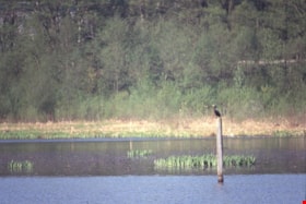
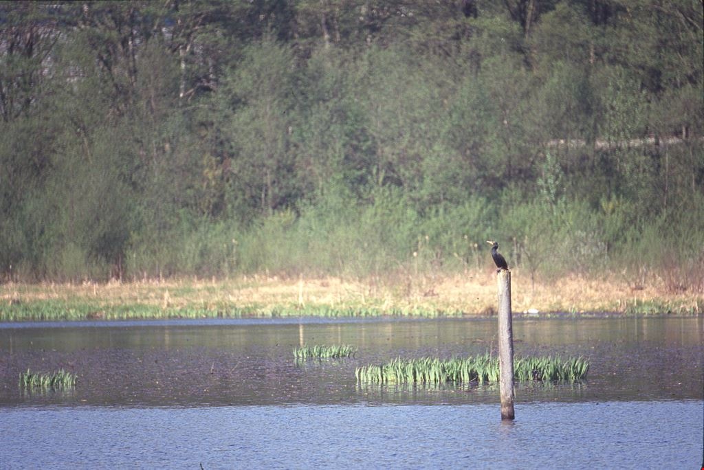
Cormorants
https://search.heritageburnaby.ca/link/archivedescription91686
- Repository
- City of Burnaby Archives
- Date
- 1982-1991
- Collection/Fonds
- Doreen Lawson fonds
- Description Level
- File
- Physical Description
- 4 photographs : col. slides ; 35 mm
- Scope and Content
- File consists of photographs of cormorants. In three of the photographs cormorants are perched on wooded structures on Burnaby Lake; in the forth a cormorant is depicted taking flight from the water. The cormorants are medium-to-large sized birds with dark feathers and long, thin yellow bills.
- Repository
- City of Burnaby Archives
- Date
- 1982-1991
- Collection/Fonds
- Doreen Lawson fonds
- Physical Description
- 4 photographs : col. slides ; 35 mm
- Description Level
- File
- Record No.
- 618-004
- Access Restriction
- No restrictions
- Reproduction Restriction
- No restrictions
- Accession Number
- 2015-15
- Scope and Content
- File consists of photographs of cormorants. In three of the photographs cormorants are perched on wooded structures on Burnaby Lake; in the forth a cormorant is depicted taking flight from the water. The cormorants are medium-to-large sized birds with dark feathers and long, thin yellow bills.
- Media Type
- Photograph
- Photographer
- Lawson, Doreen A.
- Notes
- Transcribed title
- Title transcribed from note on slide sheet photographs were originally housed in
- Historic Neighbourhood
- Burnaby Lake (Historic Neighbourhood)
- Planning Study Area
- Burnaby Lake Area
Images
Tommy Douglas collection
https://search.heritageburnaby.ca/link/archivedescription100683
- Repository
- City of Burnaby Archives
- Date
- 1961-1986
- Collection/Fonds
- Tommy Douglas collection
- Description Level
- Fonds
- Physical Description
- 1.5 cm. of textual records and ephemera.
- Scope and Content
- Fonds consists of materials related to the political career of Tommy Douglas.
- Repository
- City of Burnaby Archives
- Date
- 1961-1986
- Collection/Fonds
- Tommy Douglas collection
- Physical Description
- 1.5 cm. of textual records and ephemera.
- Description Level
- Fonds
- Record No.
- 66688
- Access Restriction
- No restrictions
- Accession Number
- 2022-05
- Scope and Content
- Fonds consists of materials related to the political career of Tommy Douglas.
- History
- Thomas Clement “Tommy” Douglas served as Premier of Saskatchewan from 1944 to 1961, leading the first, and only, Co-operative Commonwealth Federation (CCF) government in Canada. Trained as a Baptist preacher, he became a skilled politician, witty orator, and advocate for social justice, believing political action was the best way to improve Canadians’ lives. As Premier, his government pioneered publicly-funded hospital insurance, which laid the foundations for a national medicare program. He became the first leader of the federal New Democratic Party in 1961, a position he held until 1971, and wielded significant influence defending human rights and strengthening Canada’s social welfare programs. Tommy Douglas was born on October 20, 1904, in Falkirk, Scotland, to a religious, working-class family, who encouraged him to debate politics, religion, and current events while being open to other perspectives. The family moved to Winnipeg, Manitoba, in 1911. His commitment to civil liberties was reinforced after witnessing ‘Bloody Saturday’ during the 1919 Winnipeg General Strike, where several strikers were killed and leaders arrested. He would go on to become an ordained pastor in Weyburn, Saskatchewan, and, in 1933, helped found the CCF, a political coalition of progressive and labour groups with a platform centered on economic reform. Douglas won a federal seat with the CCF in 1935, serving two terms before entering provincial politics. First elected premier of Saskatchewan in 1944, he would serve five terms. His government’s ambitious platform included new administrative structures for economic planning and an innovative program of social reform. It introduced labour and human rights codes and pioneered a new approach to relations between Indigenous Peoples and government. Douglas was also an important influence on the development of medicare in Canada, building on the Saskatchewan tradition of co-operative values to implement the first publicly funded, universally accessible hospital insurance plan in 1947. This was followed by a plan to cover physician services, which concerned doctors worried about regimentation and interference in the doctor-patient relationship. A disruptive 1962 doctor’s strike delayed its implementation, but a compromise was reached and, despite some lingering hostilities, both programs would set the standard for other provinces. This led to federal cost-sharing to facilitate universal, Canada-wide public health care, which remains deeply tied to Canadian identity and values. In 1961, Douglas returned to federal politics as leader of the newly-created New Democratic Party, an alliance between the old CCF and the Canadian Labour Congress. As the third party in Parliament, it was able to use its position to influence minority governments in pushing for the adoption of national social welfare programs, such as medicare and old age pensions. Often the conscience of Parliament on civil liberties, Douglas was one of the few who spoke against the invocation of the War Measures Act during the October Crisis of 1970. Douglas remains a much-admired political figure and the namesake of one of the branches of the Burnaby Public Library. Even those who disagree with his politics admire his pragmatism, oratory skills, integrity, and commitment to social justice. But most of all, Tommy Douglas is an icon for medicare. For his lifetime of service, he was made a Companion of the Order of Canada in 1980. Source: https://www.canada.ca/en/parks-canada/news/2019/03/thomas-clement-tommy-douglas-19041986.html.
- Media Type
- Textual Record
Planning Department fonds
https://search.heritageburnaby.ca/link/archivedescription102
- Repository
- City of Burnaby Archives
- Date
- 1940-2016
- Collection/Fonds
- Planning Department fonds
- Description Level
- Fonds
- Physical Description
- 80 m of textual records and other material
- Scope and Content
- Fonds consists of those records created during the regular conduct of business by the Planning Department and its predecessor agencies according to their mandate of providing professional and technical advice to Council on the current and future uses of City land and resources.
- Repository
- City of Burnaby Archives
- Date
- 1940-2016
- Collection/Fonds
- Planning Department fonds
- Physical Description
- 80 m of textual records and other material
- Description Level
- Fonds
- File Class
- 71000 10 (add. 2020)
- 71000 20 (add. 2020)
- 71000 30 (add. 2020)
- 71000 40 (add. 2020)
- Access Restriction
- Subject to FOIPPA
- Reproduction Restriction
- Reproductions subject to FOIPPA.
- Scope and Content
- Fonds consists of those records created during the regular conduct of business by the Planning Department and its predecessor agencies according to their mandate of providing professional and technical advice to Council on the current and future uses of City land and resources.
- History
- The City of Burnaby Planning Department was established on October 9, 1956, when the City Council unanimously carried the motion to create a distinct department to deal with planning issues within the City and appointed Mr. William John Blakely as its head. This decision followed a report and recommendation made by the City’s Chief Administrative Officer which indicated that the role of the Planning Engineer and his staff had quickly expanded to become a separate division within the Engineering Department and that they were functioning as an independent unit in all but name. The proposed separation of the Engineering and Planning departments had been in the works since the early part of 1956 when staff changes and restructuring within the Engineering Department’s Planning Division illustrated the undermanned condition of the Planning Engineer’s office. As a result, Council asked the Chief Administrative Officer to undertake a study examining the feasibility of creating a distinct Planning Department. This report was delivered to Council on July 3, 1956, but was laid over until a Committee of the Council had the opportunity to study the functions of the Planning department to determine the necessity of the proposal. The Committee’s findings were in line with the initial report and the Planning Department was established with a staff of nine (the head Planning Engineer, an Administrative Planner, three Research Planning Assistants, a Draughtsman, a Subdivision Control Clerk, a department Clerk and a Clerk Stenographer). This new department was to offer advice and carry out the work intensive in matters such as zoning and rezoning applications, subdivision control, traffic and transportation planning, and general City planning schemes. Prior to the creation of the Planning Department, a number of bodies within the City had been responsible for fulfilling the functions carried out by this new unit. In the earliest years of the City, the members of Council were responsible for matters of planning and were assisted in their job by the City’s Engineer or any number of hired consultants (e.g. surveyors, cartographers). By 1906, however, the provincial laws surrounding the subdivision process had changed, and local governments were charged with the task of approving all private subdivision plans in their respective Municipalities. In Burnaby, the City Council passed a bylaw decreeing that all subdivision plans were to be submitted to Council for review and the City Engineer was responsible for ensuring compliance with the law. After the first Town Planning Bylaw in 1924 which restricted the type and size of construction that could occur in certain City areas, the Engineering and Building departments were to work together to oversee the enforcement of the Bylaw and the development of City plans. The scope and competence required to carry out this work grew as Burnaby’s population expanded, and in 1930 Council passed the Town Planning Commission Bylaw (No. 1028) that saw the creation of a permanent body – the Town Planning Commission – which was to serve as an advisory body to help direct the planning activities in the City while the actual work continued to be carried out by the Engineering Department. This body was comprised of the Reeve, the Chairman of the School Board, the Chairman of the Park Committee (later, the Board of Parks Commissioners), and six appointed citizens who served three-year terms. Council referred all matters of subdivisions, transportation planning, and rezoning to this Commission, which was later supported in its work by several other special or standing committees such as the Subdivision Committee, the Apartment Committee, the Transportation Committee or the Town Planning Board of Appeal. By 1953, it had become apparent that the advisory committees that were dedicated to these planning issues needed a permanent staff to carry out the work intensive, so a restructuring of the Engineering department resulted in a permanent Planning Engineer’s office being created. The Town Planning Commission continued in its advisory capacity even after the determination came in 1956 to create a separate Planning Department. When Bylaw No. 4473 was passed in 1963, the Town Planning Commission was disbanded in favour of a new Advisory Planning Commission that would turn over all routine matters such as subdivision and rezoning applications to the Planning Department but would offer advice and community input into the more complex planning schemes within the City and act as an intermediary in cases where Council and Planning staff were in disagreement. A new Advisory Planning Commission Bylaw (No. 7600) was adopted in 1980 which allowed for even greater community participation in the planning process. The Planning Department was initially responsible to report directly to Council, but in 1957, the administrative structure of Municipal staff changed with the introduction of the Burnaby Municipal Manager Bylaw (No. 3859) and from that point on, the head of the Planning Department held a direct reporting relationship to the Municipal Manager, who in turn was responsible for reporting the activities of the Department to the City Council. Over the years, the internal structure and the scope of responsibilities of the Department have changed during periods of staff reorganizations. Under the larger umbrella of the Planning and Building Department, Planning has come to be comprised of two divisions: the Current Planning Division and the Long Range Planning Division. The functions of the Current Planning Division include rezoning, subdivision, development plan areas, preliminary plan approvals, urban design, heritage planning, and urban trails and bicycle routes. The Long Range Planning Division is responsible for environmental planning concerns, transportation planning, housing, neighbourhood area planning, social planning and planning information services. In 2022, the Planning and Building Department was reorganized to better align functions with delivery of services. The Climate Action and Engery Division moved from Corporate Services to the Planning and Building Department, while Indigenous Relations and Facilities Management moved to Corporate Services and Lands and Facilities, respectively. The position of Director of Planning and Building was changed to General Manager, Planning and Development. The following individuals have served as Planning Engineer and/or Director of the Planning Department and/or General Manager, Planning and Development for the City of Burnaby: William John Blakely 1954-1956 (as Planning Engineer) 1956-1963 (as Head of the Department) Anthony P. Parr 1964-1993 Don G. Stenson 1993-2001 Jack S. Belhouse 2001-2006 Basil Luksun 2006-2012 Lou Pelletier 2012-2019 Edward Kozak 2019-present
- Formats
- Microforms exist for some records. See series descriptions.
- Media Type
- Textual Record
- Photograph
- Moving Images
- Creator
- City of Burnaby
- Notes
- Title based on contents of fonds
Ad Hoc Committee on Dog Control subseries
https://search.heritageburnaby.ca/link/archivedescription96029
- Repository
- City of Burnaby Archives
- Date
- 1983-1989
- Collection/Fonds
- City Council and Office of the City Clerk fonds
- Description Level
- Subseries
- Physical Description
- 5 folders of textual records
- Scope and Content
- Subseries consists of committee records for the Ad Hoc Committee on Dog Control including agendas, minutes, correspondence, committee reports, and terms of reference.
- Repository
- City of Burnaby Archives
- Date
- 1983-1989
- Collection/Fonds
- City Council and Office of the City Clerk fonds
- Series
- Council Committee series
- Physical Description
- 5 folders of textual records
- Description Level
- Subseries
- Scope and Content
- Subseries consists of committee records for the Ad Hoc Committee on Dog Control including agendas, minutes, correspondence, committee reports, and terms of reference.
- History
- The Ad Hoc Committee on Dog Control was established by Council on May 25, 1987. Council, at the regular Council meeting held on November 20, 1989 adopted a report to reorganize the committee structure by grouping related subjects and establishing 5 standing committees. The Ad Hoc Committee on Dog Control was dissolved and all matters relating to dog control became the responsibility of the Community Issues and Social Planning Committee.
- Media Type
- Textual Record
Administrative Fee Structure - Upland consents for leases of waterlots in North Arm of the Fraser River opposite Municipally owned properties
https://search.heritageburnaby.ca/link/councilreport19735
- Repository
- City of Burnaby Archives
- Report ID
- 1300
- Meeting Date
- 5-Aug-1980
- Format
- Council - Manager's Report
- Manager's Report No.
- 50
- Item No.
- 24
- Collection/Fonds
- City Council and Office of the City Clerk fonds
- Repository
- City of Burnaby Archives
- Report ID
- 1300
- Meeting Date
- 5-Aug-1980
- Format
- Council - Manager's Report
- Manager's Report No.
- 50
- Item No.
- 24
- Collection/Fonds
- City Council and Office of the City Clerk fonds
Documents
Burnaby Arts Council - Committee Structure
https://search.heritageburnaby.ca/link/archivedescription56388
- Repository
- City of Burnaby Archives
- Date
- 1989
- Collection/Fonds
- Burnaby Historical Society fonds
- Description Level
- File
- Physical Description
- Textual record
- Repository
- City of Burnaby Archives
- Date
- 1989
- Collection/Fonds
- Burnaby Historical Society fonds
- Subseries
- Burnaby Arts Council subseries
- Physical Description
- Textual record
- Description Level
- File
- Record No.
- 39816
- Accession Number
- BHS1998-06
- Media Type
- Textual Record
Burnaby Tennis Club's Request to Leave up Air Support Structure from 1984 May 01 to September 30 - Burnaby Lake Sports Centre
https://search.heritageburnaby.ca/link/councilreport17122
- Repository
- City of Burnaby Archives
- Report ID
- 3206
- Meeting Date
- 26-Mar-1984
- Format
- Council - Manager's Report
- Manager's Report No.
- 23
- Item No.
- 16
- Collection/Fonds
- City Council and Office of the City Clerk fonds
- Repository
- City of Burnaby Archives
- Report ID
- 3206
- Meeting Date
- 26-Mar-1984
- Format
- Council - Manager's Report
- Manager's Report No.
- 23
- Item No.
- 16
- Collection/Fonds
- City Council and Office of the City Clerk fonds
Documents
Burnaby Tennis Club's Request to Leave up their Air Support Structure from 1984 May 01 to 1984 June 30
https://search.heritageburnaby.ca/link/councilreport17033
- Repository
- City of Burnaby Archives
- Report ID
- 3290
- Meeting Date
- 7-May-1984
- Format
- Council - Manager's Report
- Manager's Report No.
- 33
- Item No.
- 9
- Collection/Fonds
- City Council and Office of the City Clerk fonds
- Repository
- City of Burnaby Archives
- Report ID
- 3290
- Meeting Date
- 7-May-1984
- Format
- Council - Manager's Report
- Manager's Report No.
- 33
- Item No.
- 9
- Collection/Fonds
- City Council and Office of the City Clerk fonds
Documents
Council Meetings and Committee Structure
https://search.heritageburnaby.ca/link/councilreport12455
- Repository
- City of Burnaby Archives
- Report ID
- 12136
- Meeting Date
- 20-Nov-1989
- Format
- Council - Committee Report
- Collection/Fonds
- City Council and Office of the City Clerk fonds
- Repository
- City of Burnaby Archives
- Report ID
- 12136
- Meeting Date
- 20-Nov-1989
- Format
- Council - Committee Report
- Collection/Fonds
- City Council and Office of the City Clerk fonds
Documents
Demolition of Existing Structure 6285 McKay Avenue Metrotown Civic Facilities Site Rezoning #30/88 Metrotown Area 14
https://search.heritageburnaby.ca/link/councilreport13204
- Repository
- City of Burnaby Archives
- Report ID
- 7878
- Meeting Date
- 6-Feb-1989
- Format
- Council - Manager's Report
- Manager's Report No.
- 11
- Item No.
- 5
- Collection/Fonds
- City Council and Office of the City Clerk fonds
- Repository
- City of Burnaby Archives
- Report ID
- 7878
- Meeting Date
- 6-Feb-1989
- Format
- Council - Manager's Report
- Manager's Report No.
- 11
- Item No.
- 5
- Collection/Fonds
- City Council and Office of the City Clerk fonds
Documents
Finance Advisory Committee subseries
https://search.heritageburnaby.ca/link/archivedescription96451
- Repository
- City of Burnaby Archives
- Date
- 1983-1985
- Collection/Fonds
- City Council and Office of the City Clerk fonds
- Description Level
- Subseries
- Physical Description
- 1 folder of textual records
- Scope and Content
- Subseries consists of committee records for the Finance Advisory Committee.
- Repository
- City of Burnaby Archives
- Date
- 1983-1985
- Collection/Fonds
- City Council and Office of the City Clerk fonds
- Series
- Council Committee series
- Subseries
- Finance Advisory Committee subseries
- Physical Description
- 1 folder of textual records
- Description Level
- Subseries
- Scope and Content
- Subseries consists of committee records for the Finance Advisory Committee.
- History
- The Finance Advisory Committee was established on September 6, 1983. The Committee was introduced in order to provide a counter balance in the decision making process with the Management Committee. Its function was to assist and advise Council on financial matters. On November 20, 1989 Council adopted a report to reorganize the Committee structure, and all matters relating to financial advisory became the responsibility of the Executive Committee of Council.
- Media Type
- Textual Record
Interview with Ron Baker by Kathy Bossort November 27, 2015 - Track 6
https://search.heritageburnaby.ca/link/oralhistory640
- Repository
- City of Burnaby Archives
- Date Range
- 1950-2015
- Length
- 0:10:17
- Summary
- This portion of the interview is about Dr. Ron Baker’s discussion about the choice of branding SFU the “engaged” university at the time of its 50th Anniversary, and the need for university Presidents to fund raise. He talks about the relationship between UBC and SFU, and the reasons for hostility t…
- Repository
- City of Burnaby Archives
- Summary
- This portion of the interview is about Dr. Ron Baker’s discussion about the choice of branding SFU the “engaged” university at the time of its 50th Anniversary, and the need for university Presidents to fund raise. He talks about the relationship between UBC and SFU, and the reasons for hostility towards UBC in the 1950s, especially from interior BC communities.
- Date Range
- 1950-2015
- Length
- 0:10:17
- Geographic Access
- Burnaby Mountain Conservation Area
- Interviewer
- Bossort, Kathy
- Interview Date
- November 27, 2015
- Scope and Content
- Recording is of an interview with Dr. Ronald James Baker conducted by Kathy Bossort. Ron Baker was one of 23 participants interviewed as part of the Community Heritage Commission’s Burnaby Mountain Oral History Project. The interview is mainly about the founding of Simon Fraser University from the perspective of SFU’s first faculty member and Director of Academic Planning, Ron Baker. Ron Baker talks about John B. Macdonald’s report on higher education in BC (1962) and how it lead to the provincial government’s decision to establish a new university and to put it in the Burnaby area. He tells stories about how the site on Burnaby Mountain was chosen; about the building of the campus; and about the challenges of planning the academic structure of the university. He also talks about the attraction of creating with little interference an institution trying out new ideas and tells stories about his working relationship with Gordon Shrum. He considers the problems created by building universities in out of the way places and the ideas such as UniverCity for dealing with SFU’s isolation.
- Biographical Notes
- Ron Baker was born in London, England, in 1924, and served in the Royal Air Force during WW2. He emigrated to Canada in 1947 and studied at UBC where he obtained a BA degree (1951) and MA degree (1953) in English Language and Literature. He served on the faculty of the UBC English Department beginning as a lecturer in 1951 and advanced to positions of Assistant Professor (1958-63) and Associate Professor (1963-65). He was a contributor to John B. Macdonald’s 1962 report “Higher Education in British Columbia and a Plan for the Future”, and continued to make significant contributions to the establishment of the community college system in Canada throughout his career. In 1963 the newly established Simon Fraser University hired Ron as its first Director of Academic Planning, serving also as first head of SFU’s English Department. In 1969 Ron left SFU to become the first President of the University of Prince Edward Island, a position he held until 1978. In 1978 he was made an Officer of the Order of Canada for his contributions to higher education. Ron has contributed to many organizations, including serving as a member of the Board of Directors of the Association of Universities and Colleges of Canada, on Canada Council, and as President of Association of Atlantic Universities and the Association of Canadian University Teachers of English. In 1990 Ron Baker was asked by the government of BC to prepare a preliminary report on the establishment of the future UNBC in Prince George. Now retired Ron Baker lives in the Edmonds area of Burnaby.
- Total Tracks
- 7
- Total Length
- 1:33:46
- Interviewee Name
- Baker, Ronald J. "Ron"
- Interview Location
- Ron Baker's home in Burnaby
- Interviewer Bio
- Kathy Bossort is a retired archivist living in Ladner, BC. She worked at the Delta Museum and Archives after graduating from SLAIS (UBC) in 2001 with Masters degrees in library science and archival studies. Kathy grew up in Calgary, Alberta, and, prior to this career change, she lived in the West Kootenays, earning her living as a cook for BC tourist lodges and work camps. She continues to be interested in oral histories as a way to fill the gaps in the written record and bring richer meaning to history.
- Collection/Fonds
- Community Heritage Commission Special Projects fonds
- Media Type
- Sound Recording
Audio Tracks
Track six of interview with Dr. Ron Baker
Track six of interview with Dr. Ron Baker
https://search.heritageburnaby.ca/media/hpo/_Data/_Archives_Oral_Histories/_Unrestricted/MSS196-013/MSS196-013_Track_6.mp3