More like 'Ray Martell, Lewis Auvache and Bill Banks'
Narrow Results By
Decade
- 2020s 96
- 2010s 62
- 2000s 683
- 1990s 552
- 1980s 470
- 1970s
- 1960s 459
- 1950s 616
- 1940s 638
- 1930s 454
- 1920s
- 1910s 610
- 1900s 242
- 1890s 40
- 1880s 50
- 1870s 3
- 1860s 1
- 1850s 1
- 1840s 1
- 1830s 1
- 1820s 1
- 1810s 1
- 1800s 1
- 1790s 1
- 1780s 1
- 1770s 1
- 1760s 1
- 1750s 1
- 1740s 1
- 1730s 1
- 1720s 1
- 1710s 1
- 1700s 1
- 1690s 1
- 1680s 1
- 1670s 1
- 1660s 1
- 1650s 1
- 1640s 1
- 1630s 1
- 1620s 1
- 1610s 1
- 1600s 1
- 1520s 1

E.W. Bateman House 'Elworth'
https://search.heritageburnaby.ca/link/landmark538
- Repository
- Burnaby Heritage Planning
- Description
- The E.W. Bateman House is a one-and-one-half storey wood-frame residence set within in a garden landscape. The house and its adjacent garage are the only historic buildings standing on their original site within the Burnaby Village Museum property.
- Associated Dates
- 1922
- Formal Recognition
- Heritage Designation, Community Heritage Register
- Other Names
- Edwin & Mary Bateman Residence
- Street View URL
- Google Maps Street View
- Repository
- Burnaby Heritage Planning
- Other Names
- Edwin & Mary Bateman Residence
- Geographic Access
- Deer Lake Avenue
- Associated Dates
- 1922
- Formal Recognition
- Heritage Designation, Community Heritage Register
- Enactment Type
- Bylaw No. 9807
- Enactment Date
- 23/11/1992
- Description
- The E.W. Bateman House is a one-and-one-half storey wood-frame residence set within in a garden landscape. The house and its adjacent garage are the only historic buildings standing on their original site within the Burnaby Village Museum property.
- Heritage Value
- The E.W. Bateman House was constructed in the Deer Lake Crescent subdivision, that was originally promoted in 1911 as an upper class suburban neighbourhood. It represents one of the first residential developments in the City of Burnaby that required buildings to be of a specific value, thus demonstrating the desire for exclusivity among the successful businessmen who chose to settle in the area. The house and grounds illustrate the reduced scale of upper-class residential construction at a time of modest returning prosperity that followed the end of the First World War, and the social, cultural, lifestyle and leisure sensibilities of the owners in the Deer Lake Crescent subdivision: such values as social aspiration, racial exclusivity, demonstration of architectural taste, and importance of a landscaped garden. The heritage value of the E.W. Bateman House is its comprehensive representation of an upper middle-class suburban residence of the early 1920s. It was built for retired CPR executive Edwin Wettenhall Bateman (1859-1957) and his wife, Mary (Dale) Bateman (1865-1935), by contractor William Dodson in 1922. The Bateman House was designed by English-born and trained architect Enoch Evans (1862-1939) of E. Evans and Son, and is an important surviving residential design by Evans, and a typical example of the eclectic Period Revival influences that were common to domestic architecture in the post-First World War era. The symmetry of the imposing front verandah, supported by exaggerated Ionic columns, gives the relatively-modest house an image of grandeur and formality. Named after Edwin Bateman’s birthplace in Cheshire, England, ‘Elworth’ also symbolizes allegiance to England and the patriotic tenor of the time. The heritage value for this house also lies in its interpretive value within the Burnaby Village Museum. The site is an important cultural feature for the interpretation of Burnaby’s heritage to the public. The E.W. Bateman House was purchased by Burnaby in 1970 and became the focal point for the development of the Museum. Both the interior and exterior of the house have been restored and interpreted to the date of original construction, including recreated room interiors and period furnishings.
- Defining Elements
- The elements that define the heritage character of the E.W. Bateman House include its: - rectangular form and massing with central entry on long side - side gable roof with front shed dormer with cedar shingle cladding - symmetry of front facade - full open front verandah inset under the roofline, supported with Ionic columns - cedar shingle siding - multi-paned double-hung wooden-sash windows, mixture of 6-over-1 and 8-over-1 - symmetrical disposition of fenestration, with double-assembly units on the ground floor - exterior shutters - two flanking brick chimneys on the side elevations - interior room layouts and original interior features such as quality millwork and original hardware - original garage at the rear of the house
- Locality
- Deer Lake Park
- Historic Neighbourhood
- Burnaby Lake (Historic Neighbourhood)
- Planning Study Area
- Morley-Buckingham Area
- Organization
- Burnaby Village Museum
- Architect
- Enoch Evans
- E. Evans and Son
- Builder
- William Dodson
- Function
- Primary Current--Museum
- Primary Historic--Single Dwelling
- Community
- Burnaby
- Cadastral Identifier
- P.I.D. No. 011-030-356 Legal Description: Parcel 1, District Lot 79 and District Lot 85, Group 1, New Westminster District, Reference Plan 77594
- Boundaries
- Burnaby Village Museum is comprised of a single municipally-owned property located at 6501 Deer Lake Avenue, Burnaby.
- Area
- 38,488.63
- Contributing Resource
- Building
- Landscape Feature
- Structure
- Ownership
- Public (local)
- Documentation
- Heritage Site Files: PC77000 20. City of Burnaby Planning and Building Department, 4949 Canada Way, Burnaby, B.C., V5G 1M2
- Subjects
- Buildings - Residential
- Buildings - Residential - Houses
- Buildings - Heritage
- Buildings - Civic - Museums
- Street Address
- 6501 Deer Lake Avenue
- Street View URL
- Google Maps Street View
Images


Barnet Lumber Company House
https://search.heritageburnaby.ca/link/landmark662
- Repository
- Burnaby Heritage Planning
- Description
- Residential building.
- Associated Dates
- 1925
- Street View URL
- Google Maps Street View
- Repository
- Burnaby Heritage Planning
- Geographic Access
- Texaco Drive
- Associated Dates
- 1925
- Description
- Residential building.
- Heritage Value
- This house is one of two surviving houses built as a “Model Home” for the manager of the Barnet Lumber Company, which was the successor to the North Pacific Lumber Company. It was used as a combined home and office. It was constructed with framing lumber and millwork sawn at the mill. Typical of the Craftsman style, the house has a front gabled roof with triangular eave brackets. It has been altered with the addition of asbestos shingles over the original siding, but retains its form, scale and massing. This house was designed by the firm of Townley & Matheson. The partnership of Fred Laughton Townley (1887-1966) and Robert Michael Matheson began in 1919, and the firm left a rich legacy of sophisticated work, including schools, commercial structures, many fine residences and the landmark Vancouver City Hall.
- Historic Neighbourhood
- Barnet (Historic Neighbourhood)
- Planning Study Area
- Burnaby Mountain Area
- Architect
- Townley & Matheson
- Area
- 2225.77
- Contributing Resource
- Building
- Ownership
- Public (local)
- Street Address
- 8007 Texaco Drive
- Street View URL
- Google Maps Street View
Images


Barnet Lumber Company House
https://search.heritageburnaby.ca/link/landmark663
- Repository
- Burnaby Heritage Planning
- Description
- Residential building.
- Associated Dates
- 1925
- Street View URL
- Google Maps Street View
- Repository
- Burnaby Heritage Planning
- Geographic Access
- Texaco Drive
- Associated Dates
- 1925
- Description
- Residential building.
- Heritage Value
- This house is one of two surviving houses built as a “Model Home” for one of the assistant managers of the Barnet Lumber Company, using framing lumber and millwork sawn at the mill. This house was also designed by the firm of Townley & Matheson. The house was raised and renovated in 1997, resulting in alterations such as new dormers and elongated porch piers.
- Historic Neighbourhood
- Barnet (Historic Neighbourhood)
- Planning Study Area
- Burnaby Mountain Area
- Architect
- Townley & Matheson
- Contributing Resource
- Building
- Ownership
- Private
- Street Address
- 8039 Texaco Drive
- Street View URL
- Google Maps Street View
Images


Capitol Hill School
https://search.heritageburnaby.ca/link/landmark564
- Repository
- Burnaby Heritage Planning
- Description
- School building.
- Associated Dates
- 1923
- Other Names
- Ecole Capitol Hill Elementary School
- Street View URL
- Google Maps Street View
- Repository
- Burnaby Heritage Planning
- Other Names
- Ecole Capitol Hill Elementary School
- Geographic Access
- Holdom Avenue
- Associated Dates
- 1923
- Description
- School building.
- Heritage Value
- This school was originally designed by Bowman & Cullerne as a two-storey, four-room school building in 1923, with a two-room addition completed in 1926 and another in 1927. Originally designed in the Arts and Crafts style, it has been altered, with the addition of stucco over the original siding and replacement windows, but has retained its original form and massing, as well as its roof-top ventilator and front gabled entrance with grouped columns. Bowman & Cullerne specialized in school design. After Harold Cullerne (1890-1976) returned from service during the First World War, he joined J.H. Bowman (1864-1943) in a partnership that lasted from 1919 to 1934. The firm’s other school designs included Seaforth School (1922, now relocated to Burnaby Village Museum), Burnaby North High School (1923), and Nelson Avenue School (1927).
- Locality
- Capitol Hill
- Historic Neighbourhood
- Capitol Hill (Historic Neighbourhood)
- Planning Study Area
- Capitol Hill Area
- Architect
- Bowman & Cullerne
- Ownership
- Public (local)
- Subjects
- Buildings - Heritage
- Buildings - Schools
- Street Address
- 350 Holdom Avenue
- Street View URL
- Google Maps Street View
Images


Douglas Road School
https://search.heritageburnaby.ca/link/landmark573
- Repository
- Burnaby Heritage Planning
- Description
- School building.
- Associated Dates
- 1928
- Other Names
- Douglas Road Elementary School
- Street View URL
- Google Maps Street View
- Repository
- Burnaby Heritage Planning
- Other Names
- Douglas Road Elementary School
- Geographic Access
- Canada Way
- Associated Dates
- 1928
- Description
- School building.
- Heritage Value
- The Douglas Road School was originally established as a two-room school in 1908 on this site, and later expanded to four classrooms. Anticipating rapid settlement of this district, the School Board purchased two acres adjoining the old building. Two of the four rooms were designed to become one large auditorium suitable for special events and public gatherings, with seating for two hundred people. The classically-influenced school has been altered with new windows and extended with additional wings, but has retained its original red-brick veneer, tan-brick quoins and bellcast octagonal roof ventilator. Designed by McCarter & Nairne, the school was built by contractor A.S. Perry. McCarter & Nairne, who also designed the Second Street School, were the Burnaby School Board architects at this time. John Y. McCarter (1886-1981) and George Nairne (1884-1953) formed their partnership in 1921 after serving overseas during the First World War. The partners began designing houses and small apartment buildings, and their commissions included Vancouver’s first skyscraper, the Marine Building (1928-30).
- Locality
- Burnaby Lake
- Historic Neighbourhood
- Burnaby Lake (Historic Neighbourhood)
- Planning Study Area
- Douglas-Gilpin Area
- Architect
- McCarter & Nairne
- Subjects
- Buildings - Heritage
- Buildings - Schools
- Street Address
- 4861 Canada Way
- Street View URL
- Google Maps Street View
Images


![Bill Banks in front of his garage, [1925] thumbnail](/media/hpo/_Data/_BVM_Images/1990/199900550011.jpg?width=280)
Bill Banks in front of his garage
https://search.heritageburnaby.ca/link/museumdescription1462
- Repository
- Burnaby Village Museum
- Date
- [1925]
- Collection/Fonds
- Burnaby Village Museum Photograph collection
- Description Level
- Item
- Physical Description
- 1 photograph : sepia ; 5.5 x 10 cm
- Scope and Content
- Photograph of W. M. (Bill) Banks standing in coveralls in front of his garage at Britton and Kingsway. Bill Banks was a mechanic with whom the Burnaby Fire Department had an agreement to maintain the fire truck and drive it to emergencies on an on-call basis. An unidentified man in a suit is standi…
- Repository
- Burnaby Village Museum
- Collection/Fonds
- Burnaby Village Museum Photograph collection
- Description Level
- Item
- Physical Description
- 1 photograph : sepia ; 5.5 x 10 cm
- Material Details
- Photograph was likely taken out of an album as there is black paper residue on its recto
- Scope and Content
- Photograph of W. M. (Bill) Banks standing in coveralls in front of his garage at Britton and Kingsway. Bill Banks was a mechanic with whom the Burnaby Fire Department had an agreement to maintain the fire truck and drive it to emergencies on an on-call basis. An unidentified man in a suit is standing on the left, smoking.
- Subjects
- Occupations - Fire Fighters
- Occupations - Mechanics
- Buildings - Commercial - Service Stations
- Geographic Access
- Kingsway
- Britton Street
- Accession Code
- BV999.55.11
- Access Restriction
- No restrictions
- Date
- [1925]
- Media Type
- Photograph
- Historic Neighbourhood
- Edmonds (Historic Neighbourhood)
- Planning Study Area
- Stride Avenue Area
- Scan Resolution
- 600
- Scan Date
- 08-Jun-09
- Scale
- 100
- Notes
- Title based on contents of photograph
Images
![Bill Banks in front of his garage, [1925] thumbnail](/media/hpo/_Data/_BVM_Images/1990/199900550011.jpg)
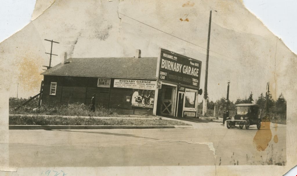
![Burnaby Garage, [1925] thumbnail](/media/hpo/_Data/_BVM_Images/1990/199900550012.jpg?width=280)
Burnaby Garage
https://search.heritageburnaby.ca/link/museumdescription1463
- Repository
- Burnaby Village Museum
- Date
- [1925]
- Collection/Fonds
- Burnaby Village Museum Photograph collection
- Description Level
- Item
- Physical Description
- 1 photograph : sepia ; 5.5 x 10 cm
- Scope and Content
- Photograph of Bill Banks' garage at Britton and Kingsway, with a sign at the edge of the driveway (to the left) which reads, "BURNABY GARAGE." Bill Banks was a mechanic with whom the Burnaby Fire Department had an agreement to maintain the fire truck and drive it to emergencies on an on-call basis.
- Repository
- Burnaby Village Museum
- Collection/Fonds
- Burnaby Village Museum Photograph collection
- Description Level
- Item
- Physical Description
- 1 photograph : sepia ; 5.5 x 10 cm
- Scope and Content
- Photograph of Bill Banks' garage at Britton and Kingsway, with a sign at the edge of the driveway (to the left) which reads, "BURNABY GARAGE." Bill Banks was a mechanic with whom the Burnaby Fire Department had an agreement to maintain the fire truck and drive it to emergencies on an on-call basis.
- Subjects
- Occupations - Fire Fighters
- Occupations - Mechanics
- Buildings - Commercial - Service Stations
- Names
- Burnaby Garage
- Geographic Access
- Kingsway
- Britton Street
- Accession Code
- BV999.55.12
- Access Restriction
- No restrictions
- Date
- [1925]
- Media Type
- Photograph
- Historic Neighbourhood
- Edmonds (Historic Neighbourhood)
- Planning Study Area
- Stride Avenue Area
- Scan Resolution
- 600
- Scan Date
- 08-Jun-09
- Scale
- 100
Images
![Burnaby Garage, [1925] thumbnail](/media/hpo/_Data/_BVM_Images/1990/199900550012.jpg)
Interview with Georgia and Alex Chronakis
https://search.heritageburnaby.ca/link/museumdescription20395
- Repository
- Burnaby Village Museum
- Date
- [1934-2023] (interview content), interviewed 8 Nov. 2023
- Collection/Fonds
- Burnaby Village Museum fonds
- Description Level
- Item
- Physical Description
- 1 sound recordings (wav) (41 min., 57 sec.) + 1 sound recording (mp3) (41 min., 57 sec.)
- Scope and Content
- Item consists of a recording of an oral history interview with Georgia Chronakis and her son Alex Chronakis conducted by Burnaby Village Museum researcher James Binks on November 8, 2023. 00:00:00 - 00:08:39 Georgia and her son share biographical details about Georgia and her husband Louis Chronak…
- Repository
- Burnaby Village Museum
- Collection/Fonds
- Burnaby Village Museum fonds
- Series
- Museum Oral Histories series
- Subseries
- Many Voices Project Interviews subseries
- Description Level
- Item
- Physical Description
- 1 sound recordings (wav) (41 min., 57 sec.) + 1 sound recording (mp3) (41 min., 57 sec.)
- Material Details
- Interviewer: James Binks Interviewees: Alex Chronakis and Georgia Chronakis Location of Interview: Fraser Wilson Room, Burnaby Village Museum Interview Date: November 8, 2023 Total Number of tracks: 1 Total Length of all Tracks: 41:57 Digital master recordings (wav) were converted to mp3 for access on Heritage Burnaby
- Scope and Content
- Item consists of a recording of an oral history interview with Georgia Chronakis and her son Alex Chronakis conducted by Burnaby Village Museum researcher James Binks on November 8, 2023. 00:00:00 - 00:08:39 Georgia and her son share biographical details about Georgia and her husband Louis Chronakis, including their Greek background, migration to Canada, marriage, children, Louis’ career as a mechanic and gas station owner and owning restaurants in White Rock and Burnaby. 00:08:40 - 00:13:59 Georgia and her son Alex recall the great memories of owning and operating their restaurant Mionas Taverna and share details of their family life in Burnaby and White Rock. 00:14:00 - 00:19:15 Alex and Georgia talk about Louis Chronakis' work experience and how he became involved in the restaurant business. They share their experiences of operating Minoas Taverna including their opening in 1986. 00:19:16 - 00:36:59 Alex and Georgia describe some of the foods that were on the menu of Minoas Taverna, the design of the restaurant, the Minoan history that it’s based on, memories of running the restaurant and why they decided to close. 00:37:00 – 00:41:52 Alex talks about his involvement with Greek festivals in Vancouver and Alex and Georgia reflect on their life in the future now that the restaurant has closed.
- History
- Interviewees biographies: Georgia Giannias Chronakis was born in Selassia, Sparta, Greece in 1941 and when she was sixteen years of age she moved to Athens. In 1964 Georgia immigrated to Canada and lived in Montreal before moving to Vancouver a few years later. In 1966, while living in Vancouver, she met and married Ilias "Louis" Chronakis who was born in Crete, Greece. Soon after marrying, Georgia and Louis Chronakis bought a house located at 3823 Kingsway and welcomed their first child, Anna. Four years later, Georgia and Louis moved to White Rock but continued to own their house on Kingsway and rented it out. While living in White Rock, they had three more children named Virginia, Alex and Ellie. Louis was a trained mechanic working independently and for various companies including CP Air, BC Ferries and Esso before deciding to get into the restaurant business. He partnered with another businessman to open a Mr. Mike's franchise and later a cafe and Greek restaurant in White Rock. In 1986, Georgia, Louis and family moved back to Burnaby and moved into a house on Sandall Street and began converting their former home on Kingsway into a restaurant which they named Minoas Greek Taverna (Minoas Taverna). They opened the restaurant on May 1, 1986, just one day before Expo '86 was opened. In 2023, after 37 years of running their restaurant they sold their business but continued to own the land and building on Kingsway. Alex Chronakis is the son of Georgia and Louis Chronakis and was born in 1972. Alex has spent time working with his family running their restaurant and has been involved in the Greek Day Festival in Vancouver. Interviewer biography: James Binks has lived in the Lower Mainland since 2009 after relocating from Ontario. James holds a Bachelor of Arts in Anthropology from the University of British Columbia, where he conducted researched on heritage, environment, and globalization in India, Nepal, and Italy. At Burnaby Village Museum, James contributed to the exhibit “Truths Not Often Told: Being South Asian in Burnaby”.
- Creator
- Burnaby Village Museum
- Subjects
- Foods
- Occupations
- Occupations - Entrepreneurs
- Occupations - Mechanics
- Buildings - Commercial - Restaurants
- Buildings - Commercial - Service Stations
- Migration
- Persons - Greek Canadians
- Geographic Access
- Kingsway
- Smith Avenue
- Street Address
- 3823 Kingsway
- Accession Code
- BV023.16.21
- Access Restriction
- No restrictions
- Reproduction Restriction
- No known restrictions
- Date
- [1934-2023] (interview content), interviewed 8 Nov. 2023
- Media Type
- Sound Recording
- Notes
- Title based on contents of item
- Transcription available
Documents
Audio Tracks
Interview with Georgia and Alex Chronakis, [1934-2023] (interview content), interviewed 8 Nov. 2023
Interview with Georgia and Alex Chronakis, [1934-2023] (interview content), interviewed 8 Nov. 2023
https://search.heritageburnaby.ca/media/hpo/_Data/_BVM_Sound_Recordings/Oral_Histories/2023_0016_0021_002.mp3
Burnaby Place
https://search.heritageburnaby.ca/link/archivedescription93691
- Repository
- City of Burnaby Archives
- Date
- June 4, 1978
- Collection/Fonds
- Burnaby Public Library Contemporary Visual Archive Project
- Description Level
- Item
- Physical Description
- 1 photograph : b&w ; 12.5 x 17.5 cm
- Scope and Content
- Photograph of a commercial mid-rise building at Patterson Avenue and Kingsway, near Central Park. A Shell gas station is next to the building and a Bank of Nova Scotia occupies the first floor. The photograph is taken from Patterson, facing east on Kingsway. Pedestrians are crossing at the intersec…
- Repository
- City of Burnaby Archives
- Date
- June 4, 1978
- Collection/Fonds
- Burnaby Public Library Contemporary Visual Archive Project
- Physical Description
- 1 photograph : b&w ; 12.5 x 17.5 cm
- Description Level
- Item
- Record No.
- 556-648
- Access Restriction
- No restrictions
- Reproduction Restriction
- Reproduce for fair dealing purposes only
- Accession Number
- 2017-57
- Scope and Content
- Photograph of a commercial mid-rise building at Patterson Avenue and Kingsway, near Central Park. A Shell gas station is next to the building and a Bank of Nova Scotia occupies the first floor. The photograph is taken from Patterson, facing east on Kingsway. Pedestrians are crossing at the intersection.
- Subjects
- Buildings - Commercial
- Buildings - Commercial - Service Stations
- Buildings - Commercial - Banks
- Media Type
- Photograph
- Photographer
- Chapman, Fred
- Notes
- Title taken from project information form
- Accompanied by a project information form and 1 photograph (b&w negative ; 9.5 x 12.5 cm)
- BPL no. 96
- Geographic Access
- Kingsway
- Central Park
- Patterson Avenue
- Historic Neighbourhood
- Central Park (Historic Neighbourhood)
- Planning Study Area
- Maywood Area
Images

![Royal Oak Garage, [1925] thumbnail](/media/hpo/_Data/_BVM_Images/1993/1993_0028_0035_001.jpg?width=280)
Royal Oak Garage
https://search.heritageburnaby.ca/link/museumdescription3178
- Repository
- Burnaby Village Museum
- Date
- [1925]
- Collection/Fonds
- Burnaby Village Museum Photograph collection
- Description Level
- Item
- Physical Description
- 1 photograph : b&w ; 19.5 x 24.5 cm
- Scope and Content
- Photograph of the Royal Oak Garage taken from a distance with a tow truck parked out front. There is a man (the driver) standing on the outside of the tow truck with one foot on the running board (another man is partially visible on the far side). Two mechanics (in overalls) are standing near the d…
- Repository
- Burnaby Village Museum
- Collection/Fonds
- Burnaby Village Museum Photograph collection
- Description Level
- Item
- Physical Description
- 1 photograph : b&w ; 19.5 x 24.5 cm
- Scope and Content
- Photograph of the Royal Oak Garage taken from a distance with a tow truck parked out front. There is a man (the driver) standing on the outside of the tow truck with one foot on the running board (another man is partially visible on the far side). Two mechanics (in overalls) are standing near the door of the garage. Three other cars are on site, including one which looks to be a 1925 Ford Runabout. Advertisements for "IMPERIAL PREMIER GASOLINE" and "SHELL GASOLINE" are visible. The Royal Oak Garage was located at 3439 Kingsway (later renumbered 5103 Kingsway).
- Subjects
- Buildings - Commercial - Service Stations
- Occupations - Mechanics
- Transportation - Automobiles
- Transportation - Trucks
- Names
- Royal Oak Garage
- Geographic Access
- Kingsway
- Street Address
- 5103 Kingsway
- Accession Code
- BV993.28.35
- Access Restriction
- No restrictions
- Reproduction Restriction
- No known restrictions
- Date
- [1925]
- Media Type
- Photograph
- Historic Neighbourhood
- Central Park (Historic Neighbourhood)
- Planning Study Area
- Marlborough Area
- Scan Resolution
- 600
- Scan Date
- 2024-04-23
- Notes
- Title based on contents of photograph
- 1 b&w copy negative accompanying
Images
![Royal Oak Garage, [1925] thumbnail](/media/hpo/_Data/_BVM_Images/1993/1993_0028_0035_001.jpg)

Highrises on Kingsway
https://search.heritageburnaby.ca/link/archivedescription93692
- Repository
- City of Burnaby Archives
- Date
- June 4, 1978
- Collection/Fonds
- Burnaby Public Library Contemporary Visual Archive Project
- Description Level
- Item
- Physical Description
- 1 photograph : b&w ; 12.5 x 17.5 cm
- Scope and Content
- Photograph of high-rises apartment buildings and the neighbourhood along Kingsway by Central Park. The photograph is taken from a high point, facing east down Kingsway. The Central Park Veterinary Hospital, Central Park Place, a railway crossing, a gas station, and the Central Park Gate are visible…
- Repository
- City of Burnaby Archives
- Date
- June 4, 1978
- Collection/Fonds
- Burnaby Public Library Contemporary Visual Archive Project
- Physical Description
- 1 photograph : b&w ; 12.5 x 17.5 cm
- Description Level
- Item
- Record No.
- 556-649
- Access Restriction
- No restrictions
- Reproduction Restriction
- Reproduce for fair dealing purposes only
- Accession Number
- 2017-57
- Scope and Content
- Photograph of high-rises apartment buildings and the neighbourhood along Kingsway by Central Park. The photograph is taken from a high point, facing east down Kingsway. The Central Park Veterinary Hospital, Central Park Place, a railway crossing, a gas station, and the Central Park Gate are visible in the photograph.
- Subjects
- Buildings - Commercial
- Buildings - Residential - Apartments
- Buildings - Commercial - Service Stations
- Geographic Features - Parks
- Monuments
- Media Type
- Photograph
- Photographer
- Chapman, Fred
- Notes
- Title taken from project information form
- Accompanied by a project information form and 1 photograph (b&w negative ; 9.5 x 12.5 cm)
- BPL no. 97
- Geographic Access
- Kingsway
- Central Park
- Historic Neighbourhood
- Central Park (Historic Neighbourhood)
- Planning Study Area
- Maywood Area
Images


Crossing Royal Oak & Rumble Street
https://search.heritageburnaby.ca/link/archivedescription93686
- Repository
- City of Burnaby Archives
- Date
- May 19, 1978
- Collection/Fonds
- Burnaby Public Library Contemporary Visual Archive Project
- Description Level
- Item
- Physical Description
- 1 photograph : b&w ; 12.5 x 17.5 cm
- Scope and Content
- Photograph of the intersection of Royal Oak Avenue and Rumble Street. Cars and pedestrians are crossing the intersection, and the signs for businesses TD Bank, Standard Oil/Chevron gas station, Gulf gas station, and Baxter's Market are visible. The photograph is taken from a corner of the intersect…
- Repository
- City of Burnaby Archives
- Date
- May 19, 1978
- Collection/Fonds
- Burnaby Public Library Contemporary Visual Archive Project
- Physical Description
- 1 photograph : b&w ; 12.5 x 17.5 cm
- Description Level
- Item
- Record No.
- 556-643
- Access Restriction
- No restrictions
- Reproduction Restriction
- Reproduce for fair dealing purposes only
- Accession Number
- 2017-57
- Scope and Content
- Photograph of the intersection of Royal Oak Avenue and Rumble Street. Cars and pedestrians are crossing the intersection, and the signs for businesses TD Bank, Standard Oil/Chevron gas station, Gulf gas station, and Baxter's Market are visible. The photograph is taken from a corner of the intersection, facing southeast.
- Subjects
- Geographic Features - Roads
- Advertising Medium - Signs and Signboards
- Buildings - Commercial - Service Stations
- Transportation - Automobiles
- Buildings - Commercial
- Media Type
- Photograph
- Photographer
- van Mannen, Mark
- Notes
- Title taken from project information form
- Accompanied by a project information form and 1 photograph (b&w negative ; 9.5 x 12.5 cm)
- BPL no. 91
- Geographic Access
- Royal Oak Avenue
- Rumble Street
- Historic Neighbourhood
- Alta Vista (Historic Neighbourhood)
- Planning Study Area
- Sussex-Nelson Area
Images


Crossing Royal Oak & Rumble Street
https://search.heritageburnaby.ca/link/archivedescription93687
- Repository
- City of Burnaby Archives
- Date
- May 19, 1978
- Collection/Fonds
- Burnaby Public Library Contemporary Visual Archive Project
- Description Level
- Item
- Physical Description
- 1 photograph : b&w ; 12.5 x 17.5 cm
- Scope and Content
- Photograph of the intersection of Royal Oak Avenue and Rumble Street. Cars and pedestrians are crossing the intersection, and the signs for businesses Grace United Pharmacy, Standard Oil/Chevron gas station, Gulf gas station, and Royal Meats are visible. The photograph is taken from the Gulf gas st…
- Repository
- City of Burnaby Archives
- Date
- May 19, 1978
- Collection/Fonds
- Burnaby Public Library Contemporary Visual Archive Project
- Physical Description
- 1 photograph : b&w ; 12.5 x 17.5 cm
- Description Level
- Item
- Record No.
- 556-644
- Access Restriction
- No restrictions
- Reproduction Restriction
- Reproduce for fair dealing purposes only
- Accession Number
- 2017-57
- Scope and Content
- Photograph of the intersection of Royal Oak Avenue and Rumble Street. Cars and pedestrians are crossing the intersection, and the signs for businesses Grace United Pharmacy, Standard Oil/Chevron gas station, Gulf gas station, and Royal Meats are visible. The photograph is taken from the Gulf gas station parking lot, facing northwest.
- Subjects
- Advertising Medium - Signs and Signboards
- Geographic Features - Roads
- Transportation - Automobiles
- Buildings - Commercial
- Buildings - Commercial - Service Stations
- Media Type
- Photograph
- Photographer
- van Mannen, Mark
- Notes
- Title taken from project information form
- Accompanied by a project information form and 1 photograph (b&w negative ; 9.5 x 12.5 cm)
- BPL no. 92
- Geographic Access
- Royal Oak Avenue
- Rumble Street
- Historic Neighbourhood
- Alta Vista (Historic Neighbourhood)
- Planning Study Area
- Sussex-Nelson Area
Images

![Allen Sharpe's Gas Station on Kingsway, [192-] (date of original), copied 1992 thumbnail](/media/hpo/_Data/_Archives_Images/_Unrestricted/315/315-049.jpg?width=280)
Allen Sharpe's Gas Station on Kingsway
https://search.heritageburnaby.ca/link/archivedescription36694
- Repository
- City of Burnaby Archives
- Date
- [192-] (date of original), copied 1992
- Collection/Fonds
- Burnaby Historical Society fonds
- Description Level
- Item
- Physical Description
- 1 photograph : b&w ; 8.7 x 12.6 cm print
- Scope and Content
- Photograph of Allen Sharpe's gas station on Kingsway (at Kathleen Avenue) with a group of men standing in front. Mr. Sharpe is on the right wearing a cap and tie. Signs on the building read, "Sharpe Service Garage / Shell Gasoline / Motor Oil / Tires."
- Repository
- City of Burnaby Archives
- Date
- [192-] (date of original), copied 1992
- Collection/Fonds
- Burnaby Historical Society fonds
- Subseries
- Burnaby Centennial Anthology subseries
- Physical Description
- 1 photograph : b&w ; 8.7 x 12.6 cm print
- Description Level
- Item
- Record No.
- 315-049
- Access Restriction
- No restrictions
- Reproduction Restriction
- No known restrictions
- Accession Number
- BHS1994-04
- Scope and Content
- Photograph of Allen Sharpe's gas station on Kingsway (at Kathleen Avenue) with a group of men standing in front. Mr. Sharpe is on the right wearing a cap and tie. Signs on the building read, "Sharpe Service Garage / Shell Gasoline / Motor Oil / Tires."
- Names
- Sharpe Service Garage
- Media Type
- Photograph
- Notes
- Title based on contents of photograph
- Geographic Access
- Kingsway
- Street Address
- 4360 Kingsway
- Historic Neighbourhood
- Central Park (Historic Neighbourhood)
- Planning Study Area
- Maywood Area
Images
![Allen Sharpe's Gas Station on Kingsway, [192-] (date of original), copied 1992 thumbnail](/media/hpo/_Data/_Archives_Images/_Unrestricted/315/315-049.jpg)
![Beaton's Garage, [1924 or 1925] (date of original), copied [1983] thumbnail](/media/hpo/_Data/_Archives_Images/_Unrestricted/126/130-001.jpg?width=280)
Beaton's Garage
https://search.heritageburnaby.ca/link/archivedescription34753
- Repository
- City of Burnaby Archives
- Date
- [1924 or 1925] (date of original), copied [1983]
- Collection/Fonds
- Burnaby Historical Society fonds
- Description Level
- Item
- Physical Description
- 1 photograph : b&w ; 12.6 x 17.7 cm print
- Scope and Content
- Photograph of Beaton's Garage located at 5698 Hastings Street at Holdom Avenue (southwest corner). Signs read, "Premier Gasoline," "Beaton's Garage," "Battery Service," and "Ignition Service."
- Repository
- City of Burnaby Archives
- Date
- [1924 or 1925] (date of original), copied [1983]
- Collection/Fonds
- Burnaby Historical Society fonds
- Subseries
- Photographs subseries
- Physical Description
- 1 photograph : b&w ; 12.6 x 17.7 cm print
- Material Details
- Printed on photograph paper, "This paper / manufactured / by Kodak"
- Description Level
- Item
- Record No.
- 130-001
- Access Restriction
- No restrictions
- Reproduction Restriction
- No known restrictions
- Accession Number
- BHS2007-04
- Scope and Content
- Photograph of Beaton's Garage located at 5698 Hastings Street at Holdom Avenue (southwest corner). Signs read, "Premier Gasoline," "Beaton's Garage," "Battery Service," and "Ignition Service."
- Names
- Beaton's Garage
- Media Type
- Photograph
- Notes
- Title based on contents of photograph
- Geographic Access
- Hastings Street
- Street Address
- 5698 Hastings Street
- Historic Neighbourhood
- Capitol Hill (Historic Neighbourhood)
- Planning Study Area
- Parkcrest-Aubrey Area
Images
![Beaton's Garage, [1924 or 1925] (date of original), copied [1983] thumbnail](/media/hpo/_Data/_Archives_Images/_Unrestricted/126/130-001.jpg)
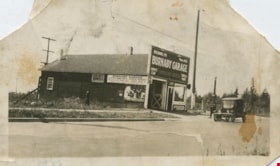
Burnaby Garage
https://search.heritageburnaby.ca/link/museumdescription1473
- Repository
- Burnaby Village Museum
- Date
- 1922
- Collection/Fonds
- Burnaby Village Museum Photograph collection
- Description Level
- Item
- Physical Description
- 1 photograph : b&w ; 5.5 x 10 cm
- Scope and Content
- Photograph of Bill Banks' "Burnaby Garage" at Britton and Kingsway. A large store front sign reads, "W.M. BANKS. PROP./ Phone 1605/ BURNABY GARAGE/ SERVICE CAR/ REPARIS OILS GREASES/ TIRES & TUBES." Bill Banks was a mechanic with whom the Burnaby Fire Department had an agreement to maintain the fir…
- Repository
- Burnaby Village Museum
- Collection/Fonds
- Burnaby Village Museum Photograph collection
- Description Level
- Item
- Physical Description
- 1 photograph : b&w ; 5.5 x 10 cm
- Material Details
- Photograph was likely taken out of an album as there is black paper residue on its recto
- Scope and Content
- Photograph of Bill Banks' "Burnaby Garage" at Britton and Kingsway. A large store front sign reads, "W.M. BANKS. PROP./ Phone 1605/ BURNABY GARAGE/ SERVICE CAR/ REPARIS OILS GREASES/ TIRES & TUBES." Bill Banks was a mechanic with whom the Burnaby Fire Department had an agreement to maintain the fire truck and drive it to emergencies on an on-call basis.
- Names
- Burnaby Garage
- Geographic Access
- Kingsway
- Accession Code
- BV999.55.22
- Access Restriction
- No restrictions
- Date
- 1922
- Media Type
- Photograph
- Historic Neighbourhood
- Edmonds (Historic Neighbourhood)
- Planning Study Area
- Stride Avenue Area
- Scan Resolution
- 600
- Scan Date
- 08-Jun-09
- Scale
- 100
- Notes
- Title based on contents of photograph
- Note in blue ink on recto of photograph reads: "1922"
Images

Closed Gas Station
https://search.heritageburnaby.ca/link/archivedescription79271
- Repository
- City of Burnaby Archives
- Date
- February 7, 1977
- Collection/Fonds
- Burnaby Public Library Contemporary Visual Archive Project
- Description Level
- Item
- Physical Description
- 1 photograph : b&w ; 11 x 16 cm mounted on cardboard
- Scope and Content
- Photograph shows a closed gas station on Kingsway near McKercher Avenue.
- Repository
- City of Burnaby Archives
- Date
- February 7, 1977
- Collection/Fonds
- Burnaby Public Library Contemporary Visual Archive Project
- Physical Description
- 1 photograph : b&w ; 11 x 16 cm mounted on cardboard
- Description Level
- Item
- Record No.
- 556-233
- Access Restriction
- No restrictions
- Reproduction Restriction
- Reproduce for fair dealing purposes only
- Accession Number
- 2013-13
- Scope and Content
- Photograph shows a closed gas station on Kingsway near McKercher Avenue.
- Media Type
- Photograph
- Notes
- Scope note taken directly from BPL photograph description.
- 1 b&w copy negative : 10 x 12.5 cm accompanying
- Photographers identified by surnames only: Carr and Vardeman
- Geographic Access
- McKercher Avenue
- Kingsway
- Historic Neighbourhood
- Central Park (Historic Neighbourhood)
- Planning Study Area
- Marlborough Area
Images


Glenwood Service Station
https://search.heritageburnaby.ca/link/archivedescription79264
- Repository
- City of Burnaby Archives
- Date
- November 14, 1976
- Collection/Fonds
- Burnaby Public Library Contemporary Visual Archive Project
- Description Level
- Item
- Physical Description
- 1 photograph : b&w ; 11 x 16 cm mounted on cardboard
- Scope and Content
- Photograph shows a view from Gilley Avenue of the Glenwood Service Station at 5894 Marine Drive.
- Repository
- City of Burnaby Archives
- Date
- November 14, 1976
- Collection/Fonds
- Burnaby Public Library Contemporary Visual Archive Project
- Physical Description
- 1 photograph : b&w ; 11 x 16 cm mounted on cardboard
- Description Level
- Item
- Record No.
- 556-228
- Access Restriction
- No restrictions
- Reproduction Restriction
- Reproduce for fair dealing purposes only
- Accession Number
- 2013-13
- Scope and Content
- Photograph shows a view from Gilley Avenue of the Glenwood Service Station at 5894 Marine Drive.
- Names
- Glenwood Service Station
- Media Type
- Photograph
- Photographer
- Campbell, Peg
- Notes
- Scope note taken directly from BPL photograph description.
- 1 b&w copy negative : 10 x 12.5 cm accompanying
- Geographic Access
- Marine Drive
- Street Address
- 5894 Marine Drive
- Historic Neighbourhood
- Fraser Arm (Historic Neighbourhood)
- Planning Study Area
- Big Bend Area
Images

![Kask's Filling Station and Store, [1927] (date of original), copied 1986 thumbnail](/media/hpo/_Data/_Archives_Images/_Unrestricted/204/204-394.jpg?width=280)
Kask's Filling Station and Store
https://search.heritageburnaby.ca/link/archivedescription35536
- Repository
- City of Burnaby Archives
- Date
- [1927] (date of original), copied 1986
- Collection/Fonds
- Burnaby Historical Society fonds
- Description Level
- Item
- Physical Description
- 1 photograph : b&w ; 12.7 x 17.8 cm print
- Scope and Content
- Photograph of Kask's Filling Station and general store on Barnet Road near Kask's Camp. Bill Kask worked here as boy and encountered fugitive felon Bill Bagley here.
- Repository
- City of Burnaby Archives
- Date
- [1927] (date of original), copied 1986
- Collection/Fonds
- Burnaby Historical Society fonds
- Subseries
- Pioneer Tales subseries
- Physical Description
- 1 photograph : b&w ; 12.7 x 17.8 cm print
- Description Level
- Item
- Record No.
- 204-394
- Access Restriction
- No restrictions
- Reproduction Restriction
- No known restrictions
- Accession Number
- BHS1988-03
- Scope and Content
- Photograph of Kask's Filling Station and general store on Barnet Road near Kask's Camp. Bill Kask worked here as boy and encountered fugitive felon Bill Bagley here.
- Media Type
- Photograph
- Notes
- Title based on contents of photograph
- Geographic Access
- Barnet Road
- Street Address
- 7501 Barnet Road
- Historic Neighbourhood
- Barnet (Historic Neighbourhood)
- Planning Study Area
- Burnaby Mountain Area
Images
![Kask's Filling Station and Store, [1927] (date of original), copied 1986 thumbnail](/media/hpo/_Data/_Archives_Images/_Unrestricted/204/204-394.jpg)
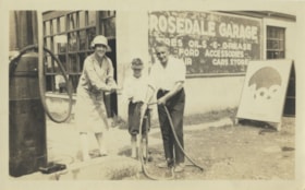
Marjorie, Fred Jr and Fred Sr
https://search.heritageburnaby.ca/link/archivedescription80157
- Repository
- City of Burnaby Archives
- Date
- 1927
- Collection/Fonds
- Montgomery family fonds
- Description Level
- Item
- Physical Description
- 1 photograph : b&w ; 7 x 12 cm
- Scope and Content
- Photograph of Marjorie Elizabeth "Marge" (Carpenter) Montgomery at Rosedale Garage with Fred Cunningham Jr and his father Fred Cunningham. The three friends are using a hose to wash off their hands.
- Repository
- City of Burnaby Archives
- Date
- 1927
- Collection/Fonds
- Montgomery family fonds
- Physical Description
- 1 photograph : b&w ; 7 x 12 cm
- Description Level
- Item
- Record No.
- 554-010
- Access Restriction
- No restrictions
- Reproduction Restriction
- No known restrictions
- Accession Number
- 2013-14
- Scope and Content
- Photograph of Marjorie Elizabeth "Marge" (Carpenter) Montgomery at Rosedale Garage with Fred Cunningham Jr and his father Fred Cunningham. The three friends are using a hose to wash off their hands.
- Media Type
- Photograph
- Notes
- Title based on contents of photograph
- Note in pencil on verso of photograph reads: "Marge on her [illegible] from Honolulu (honeymoon) / Onkie"
Images
