More like 'Heritage Village'
Narrow Results By
Decade
- 2020s 86
- 2010s 43
- 2000s 509
- 1990s 387
- 1980s 382
- 1970s 741
- 1960s 290
- 1950s
- 1940s 428
- 1930s 357
- 1920s 376
- 1910s
- 1900s 174
- 1890s 23
- 1880s 49
- 1870s 3
- 1860s 1
- 1850s 1
- 1840s 1
- 1830s 1
- 1820s 1
- 1810s 1
- 1800s 1
- 1790s 1
- 1780s 1
- 1770s 1
- 1760s 1
- 1750s 1
- 1740s 1
- 1730s 1
- 1720s 1
- 1710s 1
- 1700s 1
- 1690s 1
- 1680s 1
- 1670s 1
- 1660s 1
- 1650s 1
- 1640s 1
- 1630s 1
- 1620s 1
- 1610s 1
- 1600s 1
Creator
- Aero Surveys Limited 1
- Allan Studios 3
- Associated Factory Mutual Fire Insurance Cos 1
- Barrowclough, G.A. 1
- BC Photo Card Company 1
- Binks, James 1
- Burnaby Village Museum 15
- Burnett and McGugan B.C. Land Surveyors, New Westminster 5
- Burnett, Geoffrey K. 3
- Burnett & McGugan, Engineers and Surveyors 22
- Canadian Photo Company 12
- Cantlon, Harry 9

Edmonds Baptist Church
https://search.heritageburnaby.ca/link/landmark575
- Repository
- Burnaby Heritage Planning
- Description
- Church building.
- Associated Dates
- 1912
- Street View URL
- Google Maps Street View
- Repository
- Burnaby Heritage Planning
- Geographic Access
- Walker Avenue
- Associated Dates
- 1912
- Description
- Church building.
- Heritage Value
- Beautifully designed in an Arts and Crafts idiom, this church features a textural mix of finishes including lapped siding and stucco and half timbering in the gables. The British Columbian reported in July 1912 that: "The Baptists of Edmonds will possess a fine and well planned church when the building now commenced is ready for occupation. The architects are J.P. Matheson and Son, of Vancouver, and the contractors, Muttitt and Bell, of New Westminster. The entrance porch fronts Edmonds Road and the west side faces Vancouver Road. It will have a capacity for 272 sittings, spacious aisles and choir platform besides various rooms for Baptistery, vestry and robing apartments."
- Locality
- Edmonds
- Historic Neighbourhood
- Edmonds (Historic Neighbourhood)
- Planning Study Area
- Richmond Park Area
- Architect
- J.P. Matheson & Son
- Builder
- Muttitt and Bell
- Area
- 1471.58
- Contributing Resource
- Building
- Ownership
- Private
- Names
- Matheson, John
- Street Address
- 7135 Walker Avenue
- Street View URL
- Google Maps Street View
Images


H.T. Ceperley Estate 'Fairacres' Mansion
https://search.heritageburnaby.ca/link/landmark526
- Repository
- Burnaby Heritage Planning
- Description
- 'Fairacres' is a large, two-and-one-half storey estate house in the British Arts and Crafts style, located in Deer Lake Park, with four associated original outbuildings.
- Associated Dates
- 1911
- Formal Recognition
- Heritage Designation, Community Heritage Register
- Other Names
- Henry Tracy & Grace Ceperley Estate
- Burnaby Art Gallery
- Street View URL
- Google Maps Street View
- Repository
- Burnaby Heritage Planning
- Other Names
- Henry Tracy & Grace Ceperley Estate
- Burnaby Art Gallery
- Geographic Access
- Deer Lake Avenue
- Associated Dates
- 1911
- Formal Recognition
- Heritage Designation, Community Heritage Register
- Enactment Type
- Bylaw No. 9807
- Enactment Date
- 23/11/1992
- Description
- 'Fairacres' is a large, two-and-one-half storey estate house in the British Arts and Crafts style, located in Deer Lake Park, with four associated original outbuildings.
- Heritage Value
- 'Fairacres' is important as a record of the early years of Burnaby, specifically the Deer Lake area, as a place of tranquility and beautiful scenery in which the wealthy and successful in the burgeoning cities of New Westminster and Vancouver chose to retire or to make their family homes. The main house, which anchors in style and setting the outbuildings on the estate, demonstrates the social, cultural, and aesthetic values of local wealthy businessmen and women of the early twentieth century - values such as appreciation of architectural elegance and grand interior spaces, leisure and recreation, formal landscaped gardens and scenic views. Also important is the association with the English-born and trained architect Robert Mackay Fripp (1858-1917), as this was one of his grandest residential commissions. Steeped in the current architectural trends in Great Britain, Fripp designed this sprawling mansion in the Arts and Crafts style, reflected in the architectural detailing and proportions. The style was common at the time and was often used for estate mansions as a symbol of affluence and good, modern taste as well as an affinity for all things British. Quality is displayed inside and out in the finishes and materials, orchestrated by prominent local contractor, James Charles Allen, including imported English materials of specific value such as imported Medmenham tiles in the fireplace surrounds, one of the earliest documented use of these tiles outside the United Kingdom. Detailed features of the interior woodwork were carved by Scottish-born master wood carver George Selkirk Gibson (1867-1942), who was best known for his many commissions for prominent British Columbia architect Samuel Maclure. The outbuildings at 'Fairacres' are an important record of the functioning of a large estate of the time. The Garage and Stables and the Chauffeur’s Cottage accommodated the use of automobiles, horses and carriages, and in concert with the estate's location near the new British Columbia Electric Railway 'Burnaby Lake' interurban line, illustrate the evolving nature of regional transportation and the growing bedroom communities and estates made possible by increasing options for transportation. Other outbuildings accommodated the agricultural activities that helped support the Ceperley estate. The estate was conceived and funded by American-born Grace E. Dixon Ceperley (1863-1917), who had achieved significant wealth through a bequest from her brother-in-law, Vancouver pioneer Arthur Ferguson. Her husband, Henry Tracy Ceperley (1850-1929), also American-born, was a successful and well-respected businessman who made a significant contribution to the development of the City of Vancouver. The construction of 'Fairacres' spawned the transformation of the Deer Lake area from a farming community into a preferred location for elite suburban homes. 'Fairacres' is significant to the City of Burnaby as its first civic heritage conservation project. Acquired in 1966 for conversion to Burnaby’s first art gallery, it was dedicated in 1967 to mark Canada’s Centennial of Confederation.
- Defining Elements
- Key elements that define the heritage character of the ‘Fairacres’ mansion include its: - setting in relation to the gardens, its former market garden, and the vistas to Deer Lake and other grand homes in the area - side gable roof with prominent dormers and cedar shingle cladding - verandah across the eastern (garden) facade, with its view over the landscaped gardens and the distant mountains - porte cochere with its side steps for those arriving by automobile, and central raised step for those alighting from horse-drawn carriages - rich variety of exterior elements that demonstrate the typical Arts and Crafts use of local materials such as cobble stone chimneys and foundations, wide wooden siding and half-timbering - mixture of double-hung and casement wooden-sash windows, many with multi-paned sash - lavish interior spaces, designed for entertaining on a grand scale, including a billiard room with a beamed ceiling and an inglenook fireplace, and generous living and dining rooms arranged off a central hall - quality of the interior materials such as imported Medmenham tiles in fireplace surrounds, window hardware by Hope and Sons, and leaded stained glass - interior wood work including the staircase, and carvings by George Selkirk Gibson - remaining formal Edwardian garden landscape elements, including the cross-axial plan that reflects the relationship of the mansion to its 'outdoor rooms'
- Locality
- Deer Lake Park
- Historic Neighbourhood
- Burnaby Lake (Historic Neighbourhood)
- Planning Study Area
- Douglas-Gilpin Area
- Architect
- Robert Mackay Fripp
- Function
- Primary Current--Museum
- Primary Historic--Estate
- Community
- Burnaby
- Cadastral Identifier
- P.I.D. No. 004-493-311 Legal Description: Block 3 Except: Part subdivided by Plan 26865, District Lot 79, Group 1, New Westminster District, Plan 536
- Boundaries
- ‘Fairacres’ is comprised of a single municipally-owned property located at 6344 Deer Lake Avenue, Burnaby.
- Area
- 17,065.00
- Contributing Resource
- Building
- Landscape Feature
- Ownership
- Public (local)
- Other Collection
- City of Burnaby, Visual Art Collection: Original rendering by R.P.S. Twizell Burnaby Historical Society, Community Archives: Ceperley Photograph Album Burnaby Village Museum, Collection: Carved dining room panels by G.S. Gibson and other hardware items
- Documentation
- Heritage Site Files: PC77000 20. City of Burnaby Planning and Building Department, 4949 Canada Way, Burnaby, B.C., V5G 1M2
- Names
- Ceperley, Grace
- Ceperley, H.T.
- Fripp, Robert Mackay
- Allen, James Charles
- Gibson, George Selkirk
- Street Address
- 6344 Deer Lake Avenue
- Street View URL
- Google Maps Street View
Images


H.T. Ceperley Estate 'Fairacres' Chauffeur's Cottage
https://search.heritageburnaby.ca/link/landmark529
- Repository
- Burnaby Heritage Planning
- Description
- Designed in the British Arts and Crafts style, the Chauffeur's Cottage is situated across from the main entrance to the Ceperley Mansion, and adjacent to the Garage and Stables. A long, narrow single-storey building, it was constructed by joining together two modest estate cottages.
- Associated Dates
- 1911
- Formal Recognition
- Heritage Designation, Community Heritage Register
- Repository
- Burnaby Heritage Planning
- Geographic Access
- Deer Lake Avenue
- Associated Dates
- 1911
- Formal Recognition
- Heritage Designation, Community Heritage Register
- Enactment Type
- Bylaw No. 9807
- Enactment Date
- 23/11/1992
- Description
- Designed in the British Arts and Crafts style, the Chauffeur's Cottage is situated across from the main entrance to the Ceperley Mansion, and adjacent to the Garage and Stables. A long, narrow single-storey building, it was constructed by joining together two modest estate cottages.
- Heritage Value
- The outbuildings at 'Fairacres' are a rare surviving architecturally designed ensemble of agricultural structures that exist in complementary harmony with the main estate house. Architect Robert Mackay Fripp (1858-1917) was retained by the Ceperleys to design several original outbuildings on their estate at the same time as the main house was constructed. The Chauffeur's Cottage illustrates the increasing importance of the automobile in the lives of the wealthy of the early twentieth century. It also demonstrates Grace and Henry Tracy Ceperley's social aspirations and grand-country-estate pretension in having a chauffeur. The cottage's location - close to the garage and convenient, but not adjacent, to the main house - enhances the grand country house landscape design and contributes to the overall composition of the estate's plan. The Arts and Crafts styled Chauffeur's Cottage is important as an indicator of the aesthetic and social sensibilities of the Ceperley family in retaining an architect to design a modest building for staff accommodation.
- Defining Elements
- Key elements that define the heritage character of the 'Fairacres' Chauffeur's Cottage include its: - location, in relation to the main house and in close proximity to the Garage and Stables buildings - side gable roof with cedar shingle cladding - Arts and Crafts architectural features such as the jerkin-headed door hood, a reference to the thatched-roofed cottages of southern England; eight-paned wooden-sash casement windows; and cedar-shingled exterior - two internal brick chimneys - modest, functional interior, with simple trim and lack of pretension
- Locality
- Deer Lake Park
- Historic Neighbourhood
- Burnaby Lake (Historic Neighbourhood)
- Planning Study Area
- Douglas-Gilpin Area
- Architect
- Robert Mackay Fripp
- Function
- Primary Historic--Outbuilding
- Community
- Burnaby
- Cadastral Identifier
- P.I.D. No. 004-493-311 Legal Description: Block 3 Except: Part subdivided by Plan 26865, District Lot 79, Group 1, New Westminster District, Plan 536
- Boundaries
- ‘Fairacres’ is comprised of a single municipally-owned property located at 6344 Deer Lake Avenue, Burnaby.
- Area
- 17,065.00
- Contributing Resource
- Building
- Landscape Feature
- Ownership
- Public (local)
- Other Collection
- Burnaby Historical Society, Community Archives: Ceperley Photograph Album Burnaby Village Museum, Collection: Chinese ‘Tiger Whiskey’ and opium bottles found during restoration
- Documentation
- Heritage Site Files: PC77000 20. City of Burnaby Planning and Building Department, 4949 Canada Way, Burnaby, B.C., V5G 1M2
- Street Address
- 6344 Deer Lake Avenue
Images


H.T. Ceperley Estate 'Fairacres' Garage & Stables
https://search.heritageburnaby.ca/link/landmark530
- Repository
- Burnaby Heritage Planning
- Description
- Designed in the British Arts and Crafts style, the ‘Fairacres’ Garage and Stables is a two-storey wood frame building located on the 'Fairacres' estate, situated to the north of the Chauffeur's Cottage; at the south end of the structure is a single vehicle garage and to the north are several stable…
- Associated Dates
- 1911
- Formal Recognition
- Heritage Designation, Community Heritage Register
- Street View URL
- Google Maps Street View
- Repository
- Burnaby Heritage Planning
- Geographic Access
- Deer Lake Avenue
- Associated Dates
- 1911
- Formal Recognition
- Heritage Designation, Community Heritage Register
- Enactment Type
- Bylaw No. 9807
- Enactment Date
- 23/11/1992
- Description
- Designed in the British Arts and Crafts style, the ‘Fairacres’ Garage and Stables is a two-storey wood frame building located on the 'Fairacres' estate, situated to the north of the Chauffeur's Cottage; at the south end of the structure is a single vehicle garage and to the north are several stables for carriage, riding, and draught horses, a coach house, and tack room; the upper floor was originally a hay loft.
- Heritage Value
- The outbuildings at 'Fairacres' are a rare surviving architecturally designed ensemble of agricultural structures that exist in complementary harmony with the main estate house. Architect Robert Mackay Fripp (1858-1917) was retained by the Ceperleys to design several original outbuildings on their estate at the same time as the main house was constructed. The Garage and Stables building is important as a record of its era when transportation modes were in transition and the horse-drawn carriage, while still in use, was giving way to the automobile. The relative spatial arrangements within the building are a valuable indication of the economy of space associated with the automobile, as compared to the horse. The extent of the stabling arrangements signifies not only the use of carriage horses but also the continued reliance on draught horses in farming activities in this era. As well, it is an indication of the fashionable nature of equestrianism for wealthy families during this time. The building is important as a demonstration of the aesthetics of the Ceperley family in having an architect-designed outbuilding and obtaining craftsmanship and materials of the highest quality for each structure on their estate.
- Defining Elements
- Key elements that define the heritage character of the 'Fairacres' Garage and Stables include its: - location within easy reach of the main house and in close proximity to the Chauffeur's Cottage - floor plan with the garage at one end, close to the Chauffeur's Cottage, and stables and equine facilities at the other - variety and complexity of the roofline, including gable wall dormers, gable-on-hip roof ends, and half-hip extensions - Arts and Crafts architectural features of the exterior such as the shingle wall cladding articulated with a chevron-patterned course of shingles at the first floor level; casement windows; and deep eaves with additional purlins to support the overhang - original stable doors with hand-made forged-iron door hardware - multi-paned wooden-sash windows, some retaining original wire glass
- Locality
- Deer Lake Park
- Historic Neighbourhood
- Burnaby Lake (Historic Neighbourhood)
- Planning Study Area
- Douglas-Gilpin Area
- Architect
- Robert Mackay Fripp
- Function
- Primary Historic--Outbuilding
- Community
- Burnaby
- Cadastral Identifier
- P.I.D. No. 004-493-311 Legal Description: Block 3 Except: Part subdivided by Plan 26865, District Lot 79, Group 1, New Westminster District, Plan 536
- Boundaries
- ‘Fairacres’ is comprised of a single municipally-owned property located at 6344 Deer Lake Avenue, Burnaby.
- Area
- 17,065.00
- Contributing Resource
- Building
- Landscape Feature
- Ownership
- Public (local)
- Other Collection
- Burnaby Historical Society, Community Archives: Ceperley Photograph Album
- Documentation
- Heritage Site Files: PC77000 20. City of Burnaby Planning and Building Department, 4949 Canada Way, Burnaby, B.C., V5G 1M2
- Street Address
- 6344 Deer Lake Avenue
- Street View URL
- Google Maps Street View
Images


Helen 'The Swinging Girl' Neon Sign
https://search.heritageburnaby.ca/link/landmark591
- Repository
- Burnaby Heritage Planning
- Description
- Commercial building.
- Associated Dates
- 1956
- Formal Recognition
- Heritage Designation, Community Heritage Register
- Other Names
- Helen's Childrens Wear Sign
- Street View URL
- Google Maps Street View
- Repository
- Burnaby Heritage Planning
- Other Names
- Helen's Childrens Wear Sign
- Geographic Access
- Hastings Street
- Associated Dates
- 1956
- Formal Recognition
- Heritage Designation, Community Heritage Register
- Enactment Type
- Bylaw No. 12771
- Enactment Date
- 19/04/2010
- Description
- Commercial building.
- Heritage Value
- While the building here is of some importance as the former North Burnaby municipal office, its primary importance is its delightful neon sign that has become a North Burnaby landmark. Helen Arnold opened Helen’s Childrens Wear shop in the building next door to the old Municipal offices in 1948. In 1955, when North Burnaby moved out, she moved into the vacated building. As part of the renovations, Helen enlisted the assistance of her good friend Jimmy Wallace, owner of Vancouver’s Wallace Neon Company, to create a new sign for her expanded business. One of the company’s designers, Reeve Lehman, created the swinging neon girl that was installed in 1956. Designed in two parts, one section of the sign is cloud shaped and reads ‘Helen’s’ while the other section is a moving representation of a little girl on a swing. The sign is nine feet six inches high and nine feet wide, and the lower section is animated with an internal motor and gears. It immediately became a landmark on Hastings Street, and recently the sign’s design fame has spread far and wide as one of the best surviving examples of kinetic neon art in North America.
- Locality
- Vancouver Heights
- Historic Neighbourhood
- Vancouver Heights (Historic Neighbourhood)
- Planning Study Area
- Willingdon Heights Area
- Community
- Burnaby
- Names
- Helen's Childrens Wear
- Street Address
- 4142 Hastings Street
- Street View URL
- Google Maps Street View
Images


Interview with Allan Nixon by Rod Fowler February 21, 1990 - Track 7
https://search.heritageburnaby.ca/link/oralhistory470
- Repository
- City of Burnaby Archives
- Date Range
- 1936-1990
- Length
- 00:04:34
- Summary
- This portion of the interview is about Al Nixon describing the importance of good record keeping, using an example of an 1936 fire record used in a civic law suit. He expressed concerned about the lack of museum and archives facilities in Burnaby.
- Repository
- City of Burnaby Archives
- Summary
- This portion of the interview is about Al Nixon describing the importance of good record keeping, using an example of an 1936 fire record used in a civic law suit. He expressed concerned about the lack of museum and archives facilities in Burnaby.
- Date Range
- 1936-1990
- Length
- 00:04:34
- Interviewer
- Fowler, Rod
- Interview Date
- February 21, 1990
- Scope and Content
- Recording is of an interview with Al Nixon, conducted by Rod Fowler. Al Nixon was one of eleven participants interviewed as part of the SFU/Burnaby Centennial Committee's oral history series titled, "Voices of Burnaby". The interview is mainly about the history and operations of the Burnaby Fire Department from its beginning in 1911 to 1990, and Al Nixon’s stories about the various ways photographs, records and artifacts about the department were collected and saved. The interview takes place while looking at photographs, but the information is clear nonetheless (His photographs have been deposited in the Burnaby Archives). Al Nixon also talks about his father's career as a firefighter, and about his Douglas grandparents and their home “The Gables” [Seven Gables] and neighbourhood in Burquitlam. To view “Narrow By” terms for each track expand this description and see “Notes”.
- Biographical Notes
- Al Nixon was born in New Westminster Feb. 8, 1936, the son of Provincial Fire Marshal Basil Nixon (1904-1975) and Agnes Douglas (1909-?). His mother’s family immigrated to Canada from Scotland in 1922 and lived in a large ca. 1900 home in Burquitlam at 9957 Sullivan Road called “Seven Gables” (recently demolished). His grandfather Thomas Douglas, a Coquitlam Councillor and Socialist, was murdered in 1934 in his North Road service station. Al Nixon began his career as a firefighter with the Burnaby Fire Department in 1957, eventually becoming Deputy Fire Chief Operations in 1987 and Fire Chief in 1991, before retiring in 1993. In the mid 1980's Al Nixon became interested in the department’s history after finding a photograph scrapbook at one of the firehalls. It was in very bad condition but he recognized its value and began a project to collect and save photographs, artifacts and stories about the Burnaby Fire Department, a 6 month project that turned into years. The photographs and information gathered by Al Nixon became part of Douglas Penn’s book “Follow that Fire: the history of the Burnaby Fire Department”.
- Total Tracks
- 8
- Total Length
- 0:43:35
- Interviewee Name
- Nixon, Al
- Interviewer Bio
- Rod Fowler returned to university as a mature student in the 1980s after working about twenty years in the field of economics and computerization in business in England, Europe and Western Canada. He graduated with a BA from SFU in both History and Sociology in 1987, his MA degree in Geography in 1989, and his PhD in Cultural Geography at SFU. He taught courses in Geography, Sociology, History and Canadian Studies at several Lower Mainland colleges, before becoming a full time member of the Geography Department at Kwantlen University College.
- Collection/Fonds
- SFU/Burnaby Centennial Committee fonds
- Transcript Available
- Transcript available
- Media Type
- Sound Recording
- Web Notes
- Interviews were digitized in 2015 allowing them to be accessible on Heritage Burnaby. The digitization project was initiated by the Community Heritage Commission with support from City of Burnaby Council.
Audio Tracks
Track seven of interview with Al Nixon
Track seven of interview with Al Nixon
https://search.heritageburnaby.ca/media/hpo/_Data/_Archives_Oral_Histories/_Unrestricted/MSS187-014/MSS187-014_Track_7.mp3Interview with Harry Toy, Beverley Babey and Christina Toy
https://search.heritageburnaby.ca/link/museumdescription20285
- Repository
- Burnaby Village Museum
- Date
- [1905-2023] (interview content), interviewed 25 Sep. 2023
- Collection/Fonds
- Burnaby Village Museum fonds
- Description Level
- Item
- Physical Description
- 1 sound recordings (wav) (121min., 14 sec.) + 1 sound recording (mp3) (121 min., 13 sec.)
- Scope and Content
- Item consists of a recording of an oral history interview with Harry Toy, Beverley Babey and Christina Toy conducted by Burnaby Village Museum researcher Denise Fong on September 25, 2023. The interview is divided into four sections: early life of Harry Toy, the Canada Way Food Market, the Fraser M…
- Repository
- Burnaby Village Museum
- Collection/Fonds
- Burnaby Village Museum fonds
- Series
- Museum Oral Histories series
- Subseries
- Many Voices Project Interviews subseries
- Description Level
- Item
- Physical Description
- 1 sound recordings (wav) (121min., 14 sec.) + 1 sound recording (mp3) (121 min., 13 sec.)
- Material Details
- Interviewer: Denise Fong Interviewees: Harry Toy, Beverley Babey and Christina Toy Location of Interview: Residence of Harry Toy Interview Date: September 25, 2023 Total Number of tracks: 1 Total Length of all Tracks: 02:01:13 Digital master recording (wav) was converted to mp3 for access on Heritage Burnaby
- Scope and Content
- Item consists of a recording of an oral history interview with Harry Toy, Beverley Babey and Christina Toy conducted by Burnaby Village Museum researcher Denise Fong on September 25, 2023. The interview is divided into four sections: early life of Harry Toy, the Canada Way Food Market, the Fraser Merchants’ Association and Harry's daughters, Beverley Babey and Christina Toy's memories of growing up in Burnaby. 00:00:00 – 00:23:53 Harry Toy shares biographical information about himself and his ancestors. Harry provides information about his migration to Canada and his life in Manitoba, attending school, working at the family restaurant and teaching high school. 00:23:53 – 00:41:16 Harry talks about moving his family to Burnaby and his experiences owning and operating the Canada Way Food Market. 00:41:17 – 00:54:19 Harry talks about his involvement with the Fraser Merchants Association (FMA) and provides some history about the organization. 00:54:20 – 1:22:44 Harry talks about running the Canada Way Food Market and the alterations that he made to the store over the years. Harry and his daughters comment as they look through photographs of Harry and his store and the Fraser Merchants Association. 1:22:45 – 2:01:14 Beverley and Christina talk about their early childhood in Manitoba and growing up in Burnaby. They recall what it was like growing up and working in the family owned store.
- History
- Interviewee biography: Harry Wee Koon Toy was born in February 9, 1936 in Taikong, Toisan county, Guangdong, China. Harry's father William Toy came to Canada in the early 1920s when he was ten years old. Harry arrived in Vancouver, Canada on September 9, 1950. After staying in Vancouver for one night, he joined his father in Neepawa, Manitoba where the family operated a cafe business (Royal Cafe). Harry grew up in Neepawa and graduated from the University of Manitoba and teacher's college. He became a high school teacher and worked at schools in Minnedosa and Gladstone, Manitoba teaching various subjects including, science, business, geography, history and physical education. Harry and his wife, had three daughters, Melinda, Beverley and Christina who were all born in Neepawa. When the family decided to move to the west coast, Harry was introduced to the grocery store business through an uncle who was a store operator. Around 1970, Harry purchased a grocery store at 4694 Canada Way in Burnaby which he named "Canada Way Food Market" and Harry and his daughters made their home at the back of the store. Harry owned and operated the store for approximately 40 years between 1970 and 2010. Around 1986, Harry purchased the butcher shop next door (4692 Canada Way) which was no longer in operation, expanding his store and adding a second storey to use a residence. Harry's children helped him operate the store throughout their childhood. In the early 1970s, corner stores were threatened by the spread of small chain-operated convenience stories from Eastern Canada to Vancouver. Formed in April 1972, the Fraser Merchants’ Association was established to protect the rights of corner store operators. With no paid legal help, the association was incorporated in Victoria, BC for the cost of 56 cents. The benefits of being a member of the association included warehouse and group purchasing, common advertising and other advantages of being part of an association. Founded by Gary Lee Ling and five others, Fraser Merchants’ Association’s first member was Graham Grocery. By 1978, the association represented over 200 corner stores in the Lower Mainland (Delta, Surrey, White Rock, Langley, Coquitlam, and New Westminster) and Fraser Valley. The association remained active into the 1980s and 1990s. Harry has served as President of the Fraser Merchants' Association from 1992 to present. Interviewer biography: Denise Fong is a historical researcher at Burnaby Village Museum. She has degrees in Anthropology (BA) and Archaeology (MA), and is completing her doctoral degree at UBC in Interdisciplinary Studies. Her primary research interests are in Chinese Canadian history and critical heritage studies. She is the co-curator of BVM’s “Across the Pacific” exhibition, and the Museum of Vancouver’s “A Seat at the Table – Chinese Immigration and British Columbia”.
- Creator
- Burnaby Village Museum
- Subjects
- Education
- Migration
- Occupations - Teachers
- Occupations - Grocers
- Organizations
- Organizations - Business Associations
- Persons - Chinese Canadians
- Social Issues
- Social Issues - Racism
- Buildings - Commercial - Grocery Stores
- Names
- Toy, Christina
- Toy, Harry Wee Koon "Harry"
- Babey, Beverley
- Canada Way Food Market
- Fraser Merchants' Association
- Responsibility
- Fong, Denise
- Geographic Access
- Canada Way
- Street Address
- 4694 Canada Way
- Accession Code
- BV023.16.19
- Access Restriction
- No restrictions
- Reproduction Restriction
- No known restrictions
- Date
- [1905-2023] (interview content), interviewed 25 Sep. 2023
- Media Type
- Sound Recording
- Related Material
- See also: BV023.25 - Harry Toy fonds
- Notes
- Title based on contents of item
- Transcription available
Documents
Audio Tracks
Interview with Harry Toy, Beverley Babey and Christina Toy, [1905-2023] (interview content), interviewed 25 Sep. 2023
Interview with Harry Toy, Beverley Babey and Christina Toy, [1905-2023] (interview content), interviewed 25 Sep. 2023
https://search.heritageburnaby.ca/media/hpo/_Data/_BVM_Sound_Recordings/Oral_Histories/2023_0016_0019_002.mp3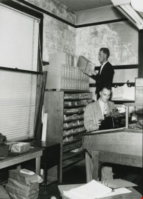
Building fatigue
https://search.heritageburnaby.ca/link/archivedescription36566
- Repository
- City of Burnaby Archives
- Date
- 1952
- Collection/Fonds
- Burnaby Historical Society fonds
- Description Level
- Item
- Physical Description
- 1 photograph : b&w ; 17.5 x 12.5 cm print
- Scope and Content
- Photograph of "BUILDING FATIGUE" inside the second Burnaby Municipal Hall.
- Repository
- City of Burnaby Archives
- Date
- 1952
- Collection/Fonds
- Burnaby Historical Society fonds
- Subseries
- Archie Miller subseries
- Physical Description
- 1 photograph : b&w ; 17.5 x 12.5 cm print
- Description Level
- Item
- Record No.
- 296-009
- Access Restriction
- No restrictions
- Reproduction Restriction
- Reproduce for fair dealing purposes only
- Accession Number
- BHS1992-36
- Scope and Content
- Photograph of "BUILDING FATIGUE" inside the second Burnaby Municipal Hall.
- Names
- Burnaby City Hall
- Media Type
- Photograph
- Photographer
- Dibble, Bob
- Notes
- Title taken from caption given to photograph in original pamphlet
- Photographs copies of originals used in "UNITE BURNABY" pamphlet which asked citizens to "VOTE YES" to the construction of a new Municipal Hall in Burnaby
- Geographic Access
- Kingsway
- Street Address
- 7282 Kingsway
- Historic Neighbourhood
- Edmonds (Historic Neighbourhood)
- Planning Study Area
- Stride Avenue Area
Images
Interior of the Burnaby Municipal Hall
https://search.heritageburnaby.ca/link/archivedescription36568
- Repository
- City of Burnaby Archives
- Date
- 1952
- Collection/Fonds
- Burnaby Historical Society fonds
- Description Level
- Item
- Physical Description
- 1 photograph : b&w ; 12.5 x 17.5 cm print
- Scope and Content
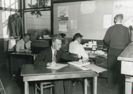
- Photograph of secretaries working inside the second Burnaby Municipal Hall.
- Repository
- City of Burnaby Archives
- Date
- 1952
- Collection/Fonds
- Burnaby Historical Society fonds
- Subseries
- Archie Miller subseries
- Physical Description
- 1 photograph : b&w ; 12.5 x 17.5 cm print
- Description Level
- Item
- Record No.
- 296-011
- Access Restriction
- No restrictions
- Reproduction Restriction
- Reproduce for fair dealing purposes only
- Accession Number
- BHS1992-36
- Scope and Content
- Photograph of secretaries working inside the second Burnaby Municipal Hall.
- Names
- Burnaby City Hall
- Media Type
- Photograph
- Photographer
- Dibble, Bob
- Notes
- Title based on contents of photograph
- Geographic Access
- Kingsway
- Street Address
- 7282 Kingsway
- Historic Neighbourhood
- Edmonds (Historic Neighbourhood)
- Planning Study Area
- Stride Avenue Area
Images

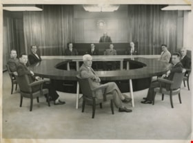
Municipal Council
https://search.heritageburnaby.ca/link/archivedescription55631
- Repository
- City of Burnaby Archives
- Date
- 1956
- Collection/Fonds
- Charles MacSorley fonds
- Description Level
- Item
- Physical Description
- 1 photograph : b&w ; 20.5 x 25.5 cm
- Scope and Content
- Photograph of the 1956 Burnaby Municipal Council in Council Chambers at Burnaby Municipal Hall. Identified in the photograph are (starting at centre, forefront and moving clockwise): Gerald Charlton, Fred Philps, Wesley Morrison, Arnold Hean, Ted Ward (Deputy Municipal Clerk), John Shaw (Municipal…
- Repository
- City of Burnaby Archives
- Date
- 1956
- Collection/Fonds
- Charles MacSorley fonds
- Physical Description
- 1 photograph : b&w ; 20.5 x 25.5 cm
- Description Level
- Item
- Record No.
- 486-025
- Access Restriction
- No restrictions
- Reproduction Restriction
- Reproduce for fair dealing purposes only
- Accession Number
- 2005-14
- Scope and Content
- Photograph of the 1956 Burnaby Municipal Council in Council Chambers at Burnaby Municipal Hall. Identified in the photograph are (starting at centre, forefront and moving clockwise): Gerald Charlton, Fred Philps, Wesley Morrison, Arnold Hean, Ted Ward (Deputy Municipal Clerk), John Shaw (Municipal Clerk), Reeve Charles MacSorley (in the back), two unkown members of staff, Samuel Hughes, William Philps and Doug Drummond.
- Subjects
- Officials - Alderman and Councillors
- Officials - Mayors and Reeves
- Buildings - Civic - City Halls
- Occupations - City Clerks
- Occupations - Civic Workers
- Names
- Charlton, Gerald
- Philps, Fred
- Morrison, Wesley
- Hean, Arnold F.C.
- Ward, Ted
- Shaw, John Horace "Jack"
- MacSorley, Charles W.
- Hughes, Samuel E.
- Philps, William P.
- Drummond, John D. "Doug"
- Media Type
- Photograph
- Photographer
- Cunningham, W.
- Notes
- Title based on contents of photograph
- Photographer's stamp on verso
- Notes on verso identify the people in the photograph
- Geographic Access
- Canada Way
- Street Address
- 4949 Canada Way
- Historic Neighbourhood
- Burnaby Lake (Historic Neighbourhood)
- Planning Study Area
- Douglas-Gilpin Area
Images

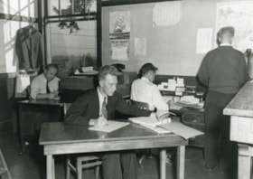
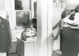
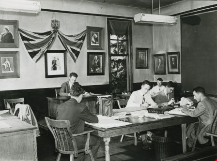
Over-crowded general office
https://search.heritageburnaby.ca/link/archivedescription36565
- Repository
- City of Burnaby Archives
- Date
- 1952
- Collection/Fonds
- Burnaby Historical Society fonds
- Description Level
- Item
- Physical Description
- 1 photograph : b&w ; 12.5 x 17.5 cm print
- Scope and Content
- Photograph of the "OVER-CROWDED GENERAL OFFICE" inside the second Burnaby Municipal Hall.
- Repository
- City of Burnaby Archives
- Date
- 1952
- Collection/Fonds
- Burnaby Historical Society fonds
- Subseries
- Archie Miller subseries
- Physical Description
- 1 photograph : b&w ; 12.5 x 17.5 cm print
- Description Level
- Item
- Record No.
- 296-008
- Access Restriction
- No restrictions
- Reproduction Restriction
- Reproduce for fair dealing purposes only
- Accession Number
- BHS1992-36
- Scope and Content
- Photograph of the "OVER-CROWDED GENERAL OFFICE" inside the second Burnaby Municipal Hall.
- Names
- Burnaby City Hall
- Media Type
- Photograph
- Photographer
- Dibble, Bob
- Notes
- Title taken from caption given to photograph in original pamphlet
- Photographs copies of originals used in "UNITE BURNABY" pamphlet which asked citizens to "VOTE YES" to the construction of a new Municipal Hall in Burnaby
- Geographic Access
- Kingsway
- Street Address
- 7282 Kingsway
- Historic Neighbourhood
- Edmonds (Historic Neighbourhood)
- Planning Study Area
- Stride Avenue Area
Images

Over-crowded police quarters
https://search.heritageburnaby.ca/link/archivedescription36567
- Repository
- City of Burnaby Archives
- Date
- 1952
- Collection/Fonds
- Burnaby Historical Society fonds
- Description Level
- Item
- Physical Description
- 1 photograph : b&w ; 12.5 x 17.5 cm print
- Scope and Content
- Photograph of the "OVER-CROWDED POLICE QUARTERS" inside the second Burnaby Municipal Hall.
- Repository
- City of Burnaby Archives
- Date
- 1952
- Collection/Fonds
- Burnaby Historical Society fonds
- Subseries
- Archie Miller subseries
- Physical Description
- 1 photograph : b&w ; 12.5 x 17.5 cm print
- Description Level
- Item
- Record No.
- 296-010
- Access Restriction
- No restrictions
- Reproduction Restriction
- Reproduce for fair dealing purposes only
- Accession Number
- BHS1992-36
- Scope and Content
- Photograph of the "OVER-CROWDED POLICE QUARTERS" inside the second Burnaby Municipal Hall.
- Media Type
- Photograph
- Photographer
- Dibble, Bob
- Notes
- Title taken from caption given to photograph in original pamphlet
- Photographs copies of originals used in "UNITE BURNABY" pamphlet which asked citizens to "VOTE YES" to the construction of a new Municipal Hall in Burnaby
- Geographic Access
- Kingsway
- Street Address
- 7282 Kingsway
- Historic Neighbourhood
- Edmonds (Historic Neighbourhood)
- Planning Study Area
- Stride Avenue Area
Images

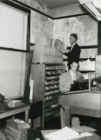
Plan filing room. Fire hazard???
https://search.heritageburnaby.ca/link/archivedescription36570
- Repository
- City of Burnaby Archives
- Date
- 1952
- Collection/Fonds
- Burnaby Historical Society fonds
- Description Level
- Item
- Physical Description
- 1 photograph : b&w ; 17.5 x 12.5 cm print
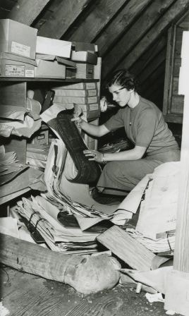
- Scope and Content
- Photograph of the "PLAN FILING ROOM [believed to be a] FIRE HAZZARD [sic]???" inside the second Burnaby Municipal Hall.
- Repository
- City of Burnaby Archives
- Date
- 1952
- Collection/Fonds
- Burnaby Historical Society fonds
- Subseries
- Archie Miller subseries
- Physical Description
- 1 photograph : b&w ; 17.5 x 12.5 cm print
- Description Level
- Item
- Record No.
- 296-013
- Access Restriction
- No restrictions
- Reproduction Restriction
- Reproduce for fair dealing purposes only
- Accession Number
- BHS1992-36
- Scope and Content
- Photograph of the "PLAN FILING ROOM [believed to be a] FIRE HAZZARD [sic]???" inside the second Burnaby Municipal Hall.
- Names
- Burnaby City Hall
- Media Type
- Photograph
- Photographer
- Dibble, Bob
- Notes
- Title taken from caption given to photograph in original pamphlet
- Photographs copies of originals used in "UNITE BURNABY" pamphlet which asked citizens to "VOTE YES" to the construction of a new Municipal Hall in Burnaby
- Geographic Access
- Kingsway
- Street Address
- 7282 Kingsway
- Historic Neighbourhood
- Edmonds (Historic Neighbourhood)
- Planning Study Area
- Stride Avenue Area
Images

Staff using Council Chamber
https://search.heritageburnaby.ca/link/archivedescription36564
- Repository
- City of Burnaby Archives
- Date
- 1952
- Collection/Fonds
- Burnaby Historical Society fonds
- Description Level
- Item
- Physical Description
- 1 photograph : b&w ; 12.5 x 17.5 cm print
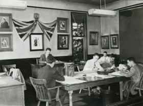
- Scope and Content
- Photograph of "STAFF USING COUNCIL CHAMBER" at the second Burnaby Municipal Hall.
- Repository
- City of Burnaby Archives
- Date
- 1952
- Collection/Fonds
- Burnaby Historical Society fonds
- Subseries
- Archie Miller subseries
- Physical Description
- 1 photograph : b&w ; 12.5 x 17.5 cm print
- Description Level
- Item
- Record No.
- 296-007
- Access Restriction
- No restrictions
- Reproduction Restriction
- Reproduce for fair dealing purposes only
- Accession Number
- BHS1992-36
- Scope and Content
- Photograph of "STAFF USING COUNCIL CHAMBER" at the second Burnaby Municipal Hall.
- Names
- Burnaby City Hall
- Media Type
- Photograph
- Photographer
- Dibble, Bob
- Notes
- Title taken from caption given to photograph in original pamphlet
- Photographs copies of originals used in "UNITE BURNABY" pamphlet which asked citizens to "VOTE YES" to the construction of a new Municipal Hall in Burnaby
- Geographic Access
- Kingsway
- Street Address
- 7282 Kingsway
- Historic Neighbourhood
- Edmonds (Historic Neighbourhood)
- Planning Study Area
- Stride Avenue Area
Images
![Burnaby Alderman, Bill (William) Lewarne, [1973]. Item no. 231-012 thumbnail](/media/hpo/_Data/_Archives_Images/_Unrestricted/205/231-012.jpg?width=280)
Interview with William A. Lewarne by Rod Fowler March 14, 1990 - Track 1
https://search.heritageburnaby.ca/link/oralhistory441
- Repository
- City of Burnaby Archives
- Date Range
- 1926-1989
- Length
- 00:10:22
- Summary
- This portion of the interview is mainly about the start of the Lewarne family ice cream business in the Depression and its history under three generations of the family. He also remembers the hard times of the Depression, the schools he attended in South Burnaby, and Mr. Seller’s shetland ponies.
- Repository
- City of Burnaby Archives
- Summary
- This portion of the interview is mainly about the start of the Lewarne family ice cream business in the Depression and its history under three generations of the family. He also remembers the hard times of the Depression, the schools he attended in South Burnaby, and Mr. Seller’s shetland ponies.
- Date Range
- 1926-1989
- Photo Info
- Burnaby Alderman, Bill (William) Lewarne, [1973]. Item no. 231-012
- Length
- 00:10:22
- Subjects
- Occupations - Entrepreneurs
- Business
- Geographic Access
- Nelson Avenue
- Historic Neighbourhood
- Alta-Vista (Historic Neighbourhood)
- Planning Study Area
- Sussex-Nelson Area
- Interviewer
- Fowler, Rod
- Interview Date
- March 14, 1990
- Scope and Content
- Recording is of an interview with former Mayor William “Bill” Lewarne, conducted by Rod Fowler. Bill Lewarne was one of eleven participants interviewed as part of the SFU/Burnaby Centennial Committee's oral history series titled, "Voices of Burnaby". The interview is mainly about Bill Lewarne’s business and political careers, and memories of growing up in South Burnaby in the 1930s. Bill Lewarne talks about his parent’s origins, his family and community struggles during the Depression, the interurban, his education, war service, and joining his father's business. He describes the start, operation and expansion of the family ice cream business, and how business life compared to political life. The interview explores the role of politics in community affairs, his political activities, the history of the BVA, and his involvement in various community organizations. To view “Narrow By” terms for each track, expand this description and see “Notes”.
- Biographical Notes
- William Alfred “Bill” Lewarne was born in Burnaby in 1926 to Ethel Cecilia Leer (1899- ) and Alfred Lewarne (1893-1962). The family, Ethel, Alfred and their three children Patricia, Beverley and William, moved to a house on Nelson Avenue in Alta Vista in 1931. Ethel still lived in the family home in 1990. Bill Lewarne attended Nelson Avenue School and South Burnaby High School (1932-1944). His father Alfred worked at Colony Farms as a dairy inspector and then for the Port of Vancouver Dairy before being laid off early in the Depression. The family struggled until in 1936 Alfred started his own ice cream business. After graduation Bill was in the army for two years, taking a refrigeration course under the veteran’s training benefit, before joining his father’s business. Three generations of the family operated the successful company, expanding from wholesale, retail and distribution of ice cream products into refrigerated warehouses and the wholesale ice business, until the business was sold to its competitor Dairyland in 1989. Bill Lewarne entered politics in 1965, first with the Nonpartisan Association (NPA) and then as a founder of the Burnaby Citizens Association (BCA). He served as an alderman on Burnaby Council 1973-1975 and 1977-1981 and as Mayor 1981-1987. In 1979 he ran for provincial office for the Social Credit Party against Rosemary Brown but lost. Bill Lewarne married June Lawrence and they had three children Robert, Leslie and Janice. He was active in many organizations: Burnaby/Willingdon Liberal Association, Seton Villa, Irish Fusileers of Canada, Lions Club, Rotary Club, Burnaby Association for Community Inclusion, and the Burnaby Hospital Foundation, and continued to be active on the Board of the BCA. Bill Lewarne died in 1995.
- Total Tracks
- 14
- Total Length
- 1:34:40
- Interviewee Name
- Lewarne, William A. "Bill"
- Interviewer Bio
- Rod Fowler returned to university as a mature student in the 1980s after working about twenty years in the field of economics and business computerization in England, Europe and Western Canada. He graduated with a BA from SFU in both History and Sociology in 1987, his MA degree in Geography in 1989, and his PhD in Cultural Geography at SFU. He taught courses in Geography, Sociology, History and Canadian Studies at several Lower Mainland colleges, before becoming a full time member of the Geography Department at Kwantlen University College.
- Collection/Fonds
- SFU/Burnaby Centennial Committee fonds
- Transcript Available
- Transcript available
- Media Type
- Sound Recording
- Web Notes
- Interviews were digitized in 2015 allowing them to be accessible on Heritage Burnaby. The digitization project was initiated by the Community Heritage Commission with support from City of Burnaby Council.
Images
![Burnaby Alderman, Bill (William) Lewarne, [1973]. Item no. 231-012 thumbnail](/media/hpo/_Data/_Archives_Images/_Unrestricted/205/231-012.jpg)
Audio Tracks
Track one of interview with Bill Lewarne
Track one of interview with Bill Lewarne
https://search.heritageburnaby.ca/media/hpo/_Data/_Archives_Oral_Histories/_Unrestricted/MSS187-019/MSS187-019_Track_1.mp3
Interview with Sev Morin by Rod Fowler April 4, 1990 - Track 2
https://search.heritageburnaby.ca/link/oralhistory538
- Repository
- City of Burnaby Archives
- Date Range
- 1950-1990
- Length
- 00:06:16
- Summary
- This portion of the interview is about Sev Morin’s description of Burnaby’s growth and business development along Kingsway and Hastings, the Lake City Industrial Park, and the purchase of property in 1958 for the Heritage Park and Art Gallery.
- Repository
- City of Burnaby Archives
- Summary
- This portion of the interview is about Sev Morin’s description of Burnaby’s growth and business development along Kingsway and Hastings, the Lake City Industrial Park, and the purchase of property in 1958 for the Heritage Park and Art Gallery.
- Date Range
- 1950-1990
- Photo Info
- Sev Morin (left) of Severin's in Burnaby (formerly the Gai Paree) hosting a gala New Year's celebration, 1979. Item no. 480-712
- Length
- 00:06:16
- Subjects
- Buildings - Commercial
- Buildings - Civic
- Buildings - Industrial
- Buildings - Schools - Universities and Colleges
- Historic Neighbourhood
- Central Park (Historic Neighbourhood)
- Burnaby Lake (Historic Neighbourhood)
- Vancouver Heights (Historic Neighbourhood)
- Edmonds (Historic Neighbourhood)
- Planning Study Area
- Burnaby Heights Area
- Lake City Area
- Burnaby Mountain Area
- Kingsway-Beresford Area
- Douglas-Gilpin Area
- Interviewer
- Fowler, Rod
- Interview Date
- April 4, 1990
- Scope and Content
- Recording is of an interview with Severin "Sev" Morin, conducted by Rod Fowler. Sev Morin was one of eleven participants interviewed as part of the SFU/Burnaby Centennial Committee's oral history series titled, "Voices of Burnaby". The interview is mainly about Sev Morin’s banquet hall, restaurant and night club business on Kingsway, originally named the “Gai Paree Supper Club” (1947-1976) and later “Severin’s” (1976-1985) and “Diego’s” (1985-1994), its function as a Burnaby landmark, and the entertainment and political people he met through his business. He also describes his many volunteer activities in Burnaby, including member of the SFU Senate, Rotary Club, Variety Club and Telethon, fund raising for Burnaby Hospital, and tourism related groups, and his political work for the federal Liberal party. He talks about his parents’ origins, the lives of his brothers Rudy and Rene, and the family’s involvement in establishing the “Gai Paree”. He also shares his views about the business and cultural development of Burnaby. To view “Narrow By” terms for each track expand this description and see “Notes”.
- Biographical Notes
- Severin “Sev” Rene Morin was born September 21, 1927, in Bonneville, Alberta, to Rene Pierre Morin (1878-1963) and Anne Marie (nee Lachiver) Morin (1886-1956). Mr. and Mrs. R. P. Morin and their son Rene Francois (1905-1954) immigrated to Edmonton, Alberta, from France in 1913, where Rene Pierre Morin worked for the C.N.R. and a second son Adolphe “Rudy” Ferdinand (1922-1969) was born, followed by their third son Severin. In 1943, after R.P. Morin retired, the family moved to Burnaby to a house on Sperling Avenue. Sometime earlier the two older Morin brothers found work in Trail at the smelter and developed musical careers. In 1946/47 the Morin family purchased property on Kingsway and built a banquet hall, the “Gai Paree Supper Club”. Sev and Rudy Morin managed the club and Rene F. Morin moved to Burnaby to join them with his band. The supper club, with its live music and dance floor, became a popular meeting place and wedding venue, eventually expanding into a restaurant and nightclub in the 1970s. The “Gai Paree” was renamed “Severin’s” in 1976 and “Diego’s” in 1985, closing finally in 1994. Sev Morin’s business life included three record stores which he owned with his friend Jack Cullen. Through these businesses Sev Morin was well known in the entertainment and hospitality industry. He and his restaurant also hosted political and social events that made the restaurant a community landmark. Sev Morin contributed many volunteer hours to community and charitable organizations, including an appointment to the SFU Senate, fundraising for the Burnaby Hospital, Director of the Variety Club and Rotary Club, and consultant for a variety of tourism related ventures. He also was active in the federal Liberal Party. Sev Morin and his wife Pauline married in 1950 and had three children. Sev Morin died at age 86 on March 28, 2014.
- Total Tracks
- 10
- Total Length
- 00:56:44
- Interviewee Name
- Morin, Severin "Sev"
- Interviewer Bio
- Rod Fowler returned to university as a mature student in the 1980s after working about twenty years in the field of economics and computerization in business in England, Europe and Western Canada. He graduated with a BA from SFU in both History and Sociology in 1987, his MA degree in Geography in 1989, and his PhD in Cultural Geography at SFU. He taught courses in Geography, Sociology, History and Canadian Studies at several Lower Mainland colleges, before becoming a full time member of the Geography Department at Kwantlen University College.
- Collection/Fonds
- SFU/Burnaby Centennial Committee fonds
- Transcript Available
- Transcript available
- Media Type
- Sound Recording
- Web Notes
- Interviews were digitized in 2015 allowing them to be accessible on Heritage Burnaby. The digitization project was initiated by the Community Heritage Commission with support from City of Burnaby Council.
Images

Audio Tracks
Track two of interview with Sev Morin
Track two of interview with Sev Morin
https://search.heritageburnaby.ca/media/hpo/_Data/_Archives_Oral_Histories/_Unrestricted/MSS187-021/MSS187-021_Track%202.mp3![Fire Hall at Oakalla, [195-] (date of original), copied 1991 thumbnail](/media/hpo/_Data/_Archives_Images/_Unrestricted/370/370-698.jpg?width=280)
Fire Hall at Oakalla
https://search.heritageburnaby.ca/link/archivedescription38111
- Repository
- City of Burnaby Archives
- Date
- [195-] (date of original), copied 1991
- Collection/Fonds
- Burnaby Historical Society fonds
- Description Level
- Item
- Physical Description
- 1 photograph : b&w ; 2.9 x 4.2 cm print on contact sheet 20.7 x 26.7 cm
- Scope and Content
- Photograph of the exterior of the fire hall at Oakalla Prison Farm.
- Repository
- City of Burnaby Archives
- Date
- [195-] (date of original), copied 1991
- Collection/Fonds
- Burnaby Historical Society fonds
- Subseries
- Burnaby Image Bank subseries
- Physical Description
- 1 photograph : b&w ; 2.9 x 4.2 cm print on contact sheet 20.7 x 26.7 cm
- Description Level
- Item
- Record No.
- 370-698
- Access Restriction
- No restrictions
- Reproduction Restriction
- Reproduce for fair dealing purposes only
- Accession Number
- BHS1999-03
- Scope and Content
- Photograph of the exterior of the fire hall at Oakalla Prison Farm.
- Names
- Oakalla Prison Farm
- Media Type
- Photograph
- Notes
- Title based on contents of photograph
- 1 b&w copy negative accompanying
- Negative has a pink cast
- Geographic Access
- Oakmount Crescent
- Street Address
- 5220 Oakmount Crescent
- Historic Neighbourhood
- Burnaby Lake (Historic Neighbourhood)
- Planning Study Area
- Oakalla Area
Images
![Fire Hall at Oakalla, [195-] (date of original), copied 1991 thumbnail](/media/hpo/_Data/_Archives_Images/_Unrestricted/370/370-698.jpg)
![Hospital at Oakalla, [195-] (date of original), copied 1991 thumbnail](/media/hpo/_Data/_Archives_Images/_Unrestricted/370/370-697.jpg?width=280)
Hospital at Oakalla
https://search.heritageburnaby.ca/link/archivedescription38110
- Repository
- City of Burnaby Archives
- Date
- [195-] (date of original), copied 1991
- Collection/Fonds
- Burnaby Historical Society fonds
- Description Level
- Item
- Physical Description
- 1 photograph : b&w ; 2.9 x 4.2 cm print on contact sheet 20.7 x 26.7 cm
- Scope and Content
- Photograph of the exterior of the hospital at Oakalla Prison Farm.
- Repository
- City of Burnaby Archives
- Date
- [195-] (date of original), copied 1991
- Collection/Fonds
- Burnaby Historical Society fonds
- Subseries
- Burnaby Image Bank subseries
- Physical Description
- 1 photograph : b&w ; 2.9 x 4.2 cm print on contact sheet 20.7 x 26.7 cm
- Description Level
- Item
- Record No.
- 370-697
- Access Restriction
- No restrictions
- Reproduction Restriction
- Reproduce for fair dealing purposes only
- Accession Number
- BHS1999-03
- Scope and Content
- Photograph of the exterior of the hospital at Oakalla Prison Farm.
- Names
- Oakalla Prison Farm
- Media Type
- Photograph
- Notes
- Title based on contents of photograph
- 1 b&w copy negative accompanying
- Negative has a pink cast
- Geographic Access
- Oakmount Crescent
- Street Address
- 5220 Oakmount Crescent
- Historic Neighbourhood
- Burnaby Lake (Historic Neighbourhood)
- Planning Study Area
- Oakalla Area
Images
![Hospital at Oakalla, [195-] (date of original), copied 1991 thumbnail](/media/hpo/_Data/_Archives_Images/_Unrestricted/370/370-697.jpg)
![Hospital at Oakalla, [195-] (date of original), copied 1991 thumbnail](/media/hpo/_Data/_Archives_Images/_Unrestricted/370/370-705.jpg?width=280)
Hospital at Oakalla
https://search.heritageburnaby.ca/link/archivedescription38118
- Repository
- City of Burnaby Archives
- Date
- [195-] (date of original), copied 1991
- Collection/Fonds
- Burnaby Historical Society fonds
- Description Level
- Item
- Physical Description
- 1 photograph : b&w ; 2.8 x 4.1 cm print on contact sheet 20.1 x 26.5 cm
- Scope and Content
- Photograph of the exterior of the hospital at Oakalla Prison Farm.
- Repository
- City of Burnaby Archives
- Date
- [195-] (date of original), copied 1991
- Collection/Fonds
- Burnaby Historical Society fonds
- Subseries
- Burnaby Image Bank subseries
- Physical Description
- 1 photograph : b&w ; 2.8 x 4.1 cm print on contact sheet 20.1 x 26.5 cm
- Description Level
- Item
- Record No.
- 370-705
- Access Restriction
- No restrictions
- Reproduction Restriction
- Reproduce for fair dealing purposes only
- Accession Number
- BHS1999-03
- Scope and Content
- Photograph of the exterior of the hospital at Oakalla Prison Farm.
- Names
- Oakalla Prison Farm
- Media Type
- Photograph
- Notes
- Title based on contents of photograph
- 1 b&w copy negative accompanying
- Negative has a pink cast
- Geographic Access
- Oakmount Crescent
- Street Address
- 5220 Oakmount Crescent
- Historic Neighbourhood
- Burnaby Lake (Historic Neighbourhood)
- Planning Study Area
- Oakalla Area
Images
![Hospital at Oakalla, [195-] (date of original), copied 1991 thumbnail](/media/hpo/_Data/_Archives_Images/_Unrestricted/370/370-705.jpg)

Bob Hutton at Municipal Hall
https://search.heritageburnaby.ca/link/archivedescription37294
- Repository
- City of Burnaby Archives
- Date
- 1958
- Collection/Fonds
- Burnaby Historical Society fonds
- Description Level
- Item
- Physical Description
- 1 photograph : b&w ; 9 x 9 cm
- Scope and Content
- Photograph of a man identified as Bob Hutton outside Burnaby Municipal Hall. Two other men are visible in the picture, but neither is identified.
- Repository
- City of Burnaby Archives
- Date
- 1958
- Collection/Fonds
- Burnaby Historical Society fonds
- Subseries
- Norah Code subseries
- Physical Description
- 1 photograph : b&w ; 9 x 9 cm
- Description Level
- Item
- Record No.
- 345-015
- Access Restriction
- No restrictions
- Reproduction Restriction
- Reproduce for fair dealing purposes only
- Accession Number
- BHS1997-05
- Scope and Content
- Photograph of a man identified as Bob Hutton outside Burnaby Municipal Hall. Two other men are visible in the picture, but neither is identified.
- Subjects
- Buildings - Civic - City Halls
- Names
- Hutton, Bob
- Burnaby City Hall
- Media Type
- Photograph
- Photographer
- Code, Norah
- Notes
- Title based on contents of photograph.
- Photographs in this collection were taken and compiled by Norah Code, former editor of the "Burnaby Courier" newspaper during the course of her work for the newspaper.
- Geographic Access
- Canada Way
- Street Address
- 4949 Canada Way
- Historic Neighbourhood
- Burnaby Lake (Historic Neighbourhood)
- Planning Study Area
- Douglas-Gilpin Area
Images
