Narrow Results By
Decade
- 2020s 84
- 2010s 213
- 2000s 392
- 1990s 564
- 1980s 550
- 1970s
- 1960s 563
- 1950s 588
- 1940s 546
- 1930s 754
- 1920s 704
- 1910s 639
- 1900s 304
- 1890s 166
- 1880s 26
- 1870s
- 1860s 15
- 1850s 7
- 1840s 3
- 1830s
- 1820s 2
- 1810s 2
- 1800s 2
- 1790s 1
- 1780s 1
- 1770s 1
- 1760s 1
- 1750s 1
- 1740s 1
- 1730s 1
- 1720s 1
- 1710s 1
- 1700s 1
- 1690s 1
- 1680s 1
- 1670s 1
- 1660s 1
- 1650s 1
- 1640s 1
- 1630s 1
- 1620s 1
- 1610s 1
- 1600s 1
Schlage locks : builders hardware, sold around the world
https://search.heritageburnaby.ca/link/museumlibrary6359
- Repository
- Burnaby Village Museum
- Collection
- Special Collection
- Material Type
- Book
- Accession Code
- BV991.45.145
- Call Number
- 381 SCH
- Place of Publication
- San Francisco
- Vancouver
- Publisher
- Shlage Lock Co.
- Publication Date
- 1971
- Physical Description
- 1 vol. : ill. (some col.) ; 30 cm.
- Inscription
- Business card for R. (Ron) Kitching adhered to inside front cover
- Names
- Oakalla Prison Farm
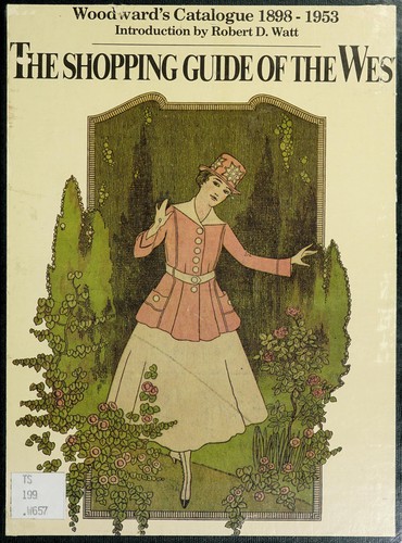
The shopping guide of the West : Woodward's catalogue, 1898-1953
https://search.heritageburnaby.ca/link/museumlibrary772
- Repository
- Burnaby Village Museum
- Author
- Woodward Stores Limited
- Publication Date
- c1977
- Call Number
- 381 WOO
- Repository
- Burnaby Village Museum
- Collection
- Reference Collection
- Material Type
- Book
- ISBN
- 0888941595
- Call Number
- 381 WOO
- Author
- Woodward Stores Limited
- Place of Publication
- Vancouver
- Publisher
- J. J. Douglas
- Publication Date
- c1977
- Physical Description
- xix, 160, 174 p. : ill. ; 28 cm
- Library Subject (LOC)
- Manufactures
- Catalogs
- Names
- Woodward's Limited
- Notes
- Reprint of the 1912 and the 1929 catalogues.
- Includes indexes.
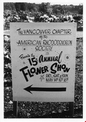
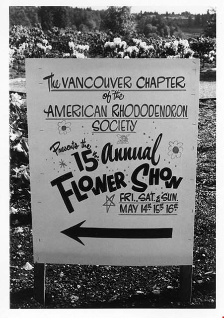
Sign for 15th annual flower show
https://search.heritageburnaby.ca/link/museumdescription2100
- Repository
- Burnaby Village Museum
- Date
- May 1971
- Collection/Fonds
- Donald Copan collection
- Description Level
- Item
- Physical Description
- 1 photograph : b&w ; 8.9 x 12.7 cm
- Scope and Content
- Photograph of sign for "15th Annual Flower Show" sponsored by the Vancouver Chapter of the American Rhodendron Society. This event was part of the Burnaby Rhododendron Festival which was part of British Columbia Centennial events.
- Repository
- Burnaby Village Museum
- Collection/Fonds
- Donald Copan collection
- Series
- Copan album series
- Description Level
- Item
- Physical Description
- 1 photograph : b&w ; 8.9 x 12.7 cm
- Scope and Content
- Photograph of sign for "15th Annual Flower Show" sponsored by the Vancouver Chapter of the American Rhodendron Society. This event was part of the Burnaby Rhododendron Festival which was part of British Columbia Centennial events.
- Subjects
- Events - Festivals
- Accession Code
- BV005.54.148
- Access Restriction
- No restrictions
- Reproduction Restriction
- May be restricted by third party rights
- Date
- May 1971
- Media Type
- Photograph
- Scan Resolution
- 600
- Scan Date
- July 21, 2020
- Scale
- 100
- Notes
- Title based on contents of photograph
Images
Sound heritage : volume 3, number 4
https://search.heritageburnaby.ca/link/museumlibrary7474
- Repository
- Burnaby Village Museum
- Collection
- Reference Collection
- Material Type
- Textual Record
- Call Number
- 971.1005 SOU v. 3, no. 4
- Place of Publication
- Victoria, BC
- Publisher
- Aural History Provincial Archives of British Columbia
- Publication Date
- 1974
- Printer
- K.M. MacDonald, Queen's Printer
- Physical Description
- iii, 53 p. : ill. ; 27 cm.
- Library Subject (LOC)
- Oral history
- Oral history--British Columbia
- British Columbia--History
- Periodicals
- Notes
- "W.J. Langlois, Editor ; Janet Cauthers, Assistant Editor ; Derek Reimer, Assistant Editor." -- title page.
- Contents: Notes from Aural History, Provincial Archives of British Columbia Commentary : Aural History and The World Soundscape Project Listening Soundwalking Cross-Canada Soundscape Tour 1973 Review: The Vancouver Soundscape
South Burnaby Garden Club subseries
https://search.heritageburnaby.ca/link/archivedescription121
- Repository
- City of Burnaby Archives
- Date
- 1915-2009
- Collection/Fonds
- Burnaby Historical Society fonds
- Description Level
- Subseries
- Physical Description
- Textual records and 1 photograph
- Scope and Content
- Subseries consists of the administrative records of the South Burnaby Garden Club from their early beginnings as the Central Park Agricultural Association and Farmer's Institute (1901-1926), the South Burnaby Horticultural Association and Farmers Institute (1927-1957) to the early 2000s.
- Repository
- City of Burnaby Archives
- Date
- 1915-2009
- Collection/Fonds
- Burnaby Historical Society fonds
- Subseries
- South Burnaby Garden Club subseries
- Physical Description
- Textual records and 1 photograph
- Description Level
- Subseries
- Accession Number
- BHS1986-36
- BHS2008-17
- Scope and Content
- Subseries consists of the administrative records of the South Burnaby Garden Club from their early beginnings as the Central Park Agricultural Association and Farmer's Institute (1901-1926), the South Burnaby Horticultural Association and Farmers Institute (1927-1957) to the early 2000s.
- History
- The South Burnaby Garden Club as formed in 1901 after a group of Central Park residents met to form a Farmers’ Institute. They leased 17 acres of Central Park from the Provincial Government and with the support of government grants constructed a two-story building on the property. The building was constructed in time for the first annual Fall Fair in September 1901. In 1903 the Institute amalgamated with the South Vancouver and Burnaby Agricultural Society to become the Central Park Agricultural Association & Farmers Institute. In 1907 the membership doubled to 520 members. Increasing urbanization and the First World War saw the last exhibition in 1919. The lease on the building expired in 1921. The Society continued to meet and hold small exhibitions in rented halls under the South Burnaby Horticultural Association name. After several name changes, the association became the South Burnaby Garden Club in 1958 and continues to this day.
- Media Type
- Photograph
- Textual Record
- Creator
- South Burnaby Garden Club
- Notes
- PC223, PC488, MSS028
- Title based on creator and contents of subseries
![Survey and Subdivision plans in New Westminster District Group 1 – Burnaby
, [1861]-[1910] thumbnail](/media/hpo/_Data/_BVM_Cartographic_Material/1977/1977_0093_0019a_001.jpg?width=280)
Survey and Subdivision plans in New Westminster District Group 1 – Burnaby
https://search.heritageburnaby.ca/link/museumdescription6988
- Repository
- Burnaby Village Museum
- Date
- [1861]-[1910]
- Collection/Fonds
- Burnaby Village Museum Map collection
- Description Level
- File
- Physical Description
- 14 plans : 3 plans : black ink on paper hand col. + 7 plans : black ink on paper + 4 plans : graphite on paper mounted on 2 sides of cardboard 76 x 102 cm
- Scope and Content
- Item consists of a large board of four New Westminster District Gp 1 - subdivision plans mounted on one side and ten New Westminster District Gp 1 - subdivision plans mounted on the other side. Side A: 1. "Plan /of / Lots 166A, 166 and 167 /, Gr.1, N.W.D. / Showing Misconstructed Roads in Gree…
- Repository
- Burnaby Village Museum
- Collection/Fonds
- Burnaby Village Museum Map collection
- Description Level
- File
- Physical Description
- 14 plans : 3 plans : black ink on paper hand col. + 7 plans : black ink on paper + 4 plans : graphite on paper mounted on 2 sides of cardboard 76 x 102 cm
- Material Details
- Scales [between 1:2376 and 1:7920]
- Index number on edge of board reads: "19"
- Scope and Content
- Item consists of a large board of four New Westminster District Gp 1 - subdivision plans mounted on one side and ten New Westminster District Gp 1 - subdivision plans mounted on the other side. Side A: 1. "Plan /of / Lots 166A, 166 and 167 /, Gr.1, N.W.D. / Showing Misconstructed Roads in Green / 5 chs = 1 in.". (plan is drawn in black ink and hand coloured in red, green and orange ink). A section in the centre of the plan is coloured in red ink and identified as "C.S. Richmond" running from the North Arm of Fraser River to Wiggins Road and divided by "New Wiggins Rd. (as gazetted)" (coloured in orange ink) and two"Constructed Road(s)" (coloured in green ink). Plan is initialed by: "RB" [sic] (in blue pencil crayon) 2. Plan of / Subdivision of / Lot 166 / Group One / New Westminster District / Scale 4 chs = 1 in. / Map No 524". Plan is drawn in graphite and signed by "Surrig [sic] Welhams [sic] / P.L.S." Plan is initialed by: "RB" [sic] (in blue pencil crayon) 3. Plan of "Survey / of Highway / For / Burnaby Council / in / Lots 13 _14 / Group One / Scale 4 chs = 1 in." Signed by "Albert J. Hill, P.L.S." Caribou Street and Caribou Road run through the centre of the plan. Plan is stamped: "Albert J. Hill, Civil Engineer / and / Provincial Land Surveyor, / New Westminster, / B.C.". Plan is initialed by: "RB" [sic] (in blue pencil crayon) 4. A Plan of Lots 166A, 166 and 167, Group One, New Westminster District (drawn in graphite). A section in the centre of the plan is identified as "C.S. Richmond" running from the North Arm of Fraser River and divided by "New Wiggins Rd. (as gazetted)" and two "Constructed Road(s)". Plan is initialed by: "RB" [sic] (in blue pencil crayon) Side B: 1. Small plan drawn in black ink (no title) identifying lots north of the "North Arm" of the Fraser River. Lots identified include: Lot 99, Lot 98, Lot 157, Lot 158, Lot 163, Lot 162, Lot 159, Lot 163, Lot 162, Lot 165, Lot 166A, Lot 155B, Lot 155A and Lot 159. "Scale 40 chains to one inch" . Plan is initialed by: "RB" [sic] (in blue pencil crayon) (Geographic location: Burnaby) 2. Small plan drawn in black ink (no title) identifying lots north of the North Arm of the Fraser River as "Lots 155, 155A, 155B, 155C, 162, 163, 164, 165, 166A and 167". Plan is initialed by: "RB" [sic] (in blue pencil crayon) (Geographic location: Burnaby) 3. Small plan drawn in black ink (no title) which identifies "Lot 151 / Reserve/ for / Race Course"; "Reserve / 64 A / L. 152 G.1"; and other Lots: 32, 33, 34, 35, 36, 38, 39. The plan is signed "Surveyor G.Turn [sic] July / 61 / from Vol 40 R.L. notes [sic]" Plan is stamped: "Albert J. Hill, Civil Engineer / and / Provincial Land Surveyor, / New Westminster, / B.C." Plan is initialed by: "RB" [sic] (in blue pencil crayon) (Geographic location: Burnaby) 4. Small plan drawn in black in with faded red colouring on centre lot identified as "Lot 34" running north from "Vancouver Road" . Plan is stamped: "Albert J. Hill, Civil Engineer / and / Provincial Land Surveyor, / New Westminster, / B.C." Plan is initialed by: "RB" [sic] (in blue pencil crayon) (Geographic location: Burnaby) 5. Plan drawn in graphite and identified as "Lot 98, Gr.1," along with the intials "RB" [sic] (both are handwritten in blue crayon pencil on top of plan) The B.C.E.Railway is identified running through the plan along with Jubilee Road and Royal Oak Road. The plan is signed with the name "Wm. Murray" and the Plan is stamped: "Albert J. Hill, Civil Engineer / and / Provincial Land Surveyor, / New Westminster, / B.C.". (Geographic location: Burnaby) 6. Plan drawn in graphite identified as "Port Lot 13, Gr.1" along with the intials "RB" [sic] (both are handwritten in blue crayon pencil on top of plan) Plan is stamped: "Albert J. Hill, Civil Engineer / and / Provincial Land Surveyor, / New Westminster, / B.C.". (Geographic location: Burnaby) 7.Plan drawn in black ink and identified as "Lot 98 G.1" along with the intials "RB" [sic] (both are handwritten in blue crayon pencil on top of plan). A "Road Reservation" is identified running north between "Electric Tramway" and connecting with "Royal Oak Road". Plan is stamped: "Albert J. Hill, Civil Engineer / and / Provincial Land Surveyor, / New Westminster, / B.C." (Geographic location: Burnaby) 8. Plan drawn in black ink and divided into two sections, the upper plan is identified as "Portion / Lots 100 / area / 101, Gr.1" and the lower plan is identified as "Portion L. 3 G. 1" along with the intials "RB" [sic] (these identifiers are handwritten in blue crayon pencil on top of the plan). Portions of Lot 100 and Lot 101 are each divided into 6 sections and the Portion of Lot 3 plan is divided into 24 sections. The plan includes a note in black ink that reads: " Received from Wm Fromme [sic] / from Wm. Trapp / Nov. 28, 1895 / A. J. T...[sic]". (Geographic location: Burnaby) 9. Plan drawn in black ink (no title) identifying soil, buildings and geographic features in southern Burnaby. The plan is bordered by "New Westminster City" (Tenth Avenue and DL 172) to the south east and DL 173 to the south, DL 158 to the west and the B.C.E. Tramway to the north. Plan includes District Lots: 155A, 158, 159, 171, 160, 53 and 95 and identifies soil, marshland and ravines throughout. Plan identifies the following features: a "Team Road" running through Lots 158 and 159 along with "Fair Orchard Soil / Even Surface Throughout / No Ravines", "Gravel and Shingle" (bottom of Lot 158), "North Arm Road" crossing "Byrne Road" and connecting with "Power House Road" which runs north to connect with "Highland Park Station" and the B.C.E. Tramway, "Power Ho" in the northeast corner of DL 160, a "Brook" connected with a "Deep Ravine" running between DL 53, DL 95 and DL 160 along with "Good Soil" and "Fair Orchard Soil" identified nearby in DL 95. Scale is identified as "10 chs = 1 in." Plan is stamped: "Albert J. Hill, Civil Engineer / and / Provincial Land Surveyor, / New Westminster, / B.C." Plan is initialed by: "RB" [sic] (in blue pencil crayon) (Geographic location: Burnaby) 10. Plan drawn in black ink (no title) with Burnaby Lake and Deer Lake at the centre. The plan is bordered by the following District Lots identified as: 117, 118 and 68 to the west, Lots 80, 79 and 85 to the southwest, Lots 11, 13, and 1 (City of New Westminster) to the south east, the North Road boundary to the east and Lots 8, 56, 57, 59, and 136 to the North. The lower right hand corner of the plan has a small inset which reads: "Burnaby Lake" and "Page 19 R.B. Notes". Plan is initialed by: "RB" [sic] (in blue pencil crayon) (Geographic location: Burnaby)
- Creator
- Hill, Albert James
- Accession Code
- HV977.93.19
- Access Restriction
- No restrictions
- Reproduction Restriction
- No known restrictions
- Date
- [1861]-[1910]
- Media Type
- Cartographic Material
- Scan Resolution
- 300
- Scale
- 72
- Notes
- Title based on contents of file
- Scale is measured in chains. (One chain equals 792 inches)
- The term "Lot" can also refer to a "District Lot”
- Some plans are stamped: "Albert J. Hill, Civil Engineer / and / Provincial Land Surveyor, / New Westminster, / B.C." and intialed: "RB" [sic]
Images
![Survey and Subdivision plans in New Westminster District Group 1 – Burnaby
, [1861]-[1910] thumbnail](/media/hpo/_Data/_BVM_Cartographic_Material/1977/1977_0093_0019a_001.jpg)

Swangard Stadium
https://search.heritageburnaby.ca/link/councilreport28959
- Repository
- City of Burnaby Archives
- Report ID
- 22904
- Meeting Date
- 6-Nov-1972
- Format
- Council - Manager's Report
- Manager's Report No.
- 72
- Item No.
- 11
- Collection/Fonds
- City Council and Office of the City Clerk fonds
- Repository
- City of Burnaby Archives
- Report ID
- 22904
- Meeting Date
- 6-Nov-1972
- Format
- Council - Manager's Report
- Manager's Report No.
- 72
- Item No.
- 11
- Collection/Fonds
- City Council and Office of the City Clerk fonds
Documents
Time-honoured recipes of the Canadian West from Nabob Foods
https://search.heritageburnaby.ca/link/museumlibrary7194
- Repository
- Burnaby Village Museum
- Collection
- Special Collection
- Material Type
- Book
- Accession Code
- BV017.25.3
- Call Number
- 641.5 NAB
- Place of Publication
- Vancouver
- Publisher
- Nabob Foods
- Publication Date
- 1973
- Physical Description
- 64 p. : col. ill. ; 23 cm.
- Library Subject (LOC)
- Cookbooks--1970-1979
- Cooking, Canadian
- Burnaby Village Museum--History
- Subjects
- Documentary Artifacts - Cook Books
- Object History
- The cook books are from her mother's kitchen.
- Notes
- "Pages 6, 12, 32, 34, 40 and 46 photographed at Heritage Village, Burnaby, British Columbia" - front endpaper
- Includes index
Transit publications
https://search.heritageburnaby.ca/link/archivedescription66115
- Repository
- City of Burnaby Archives
- Date
- 1936-2001
- Collection/Fonds
- Burnaby Historical Society fonds
- Description Level
- File
- Physical Description
- 1 file of textual records
- Scope and Content
- File consists of publications pertaining to transit routes in Burnaby and Vancouver.
- Repository
- City of Burnaby Archives
- Date
- 1936-2001
- Collection/Fonds
- Burnaby Historical Society fonds
- Subseries
- Ephemera subseries
- Physical Description
- 1 file of textual records
- Description Level
- File
- Record No.
- 42717
- Accession Number
- BHS2007-04
- Scope and Content
- File consists of publications pertaining to transit routes in Burnaby and Vancouver.
- Media Type
- Textual Record
- Notes
- Title based on contents of file
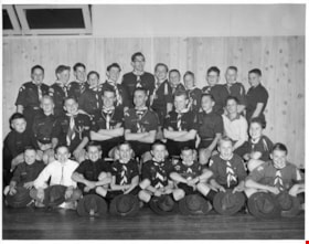
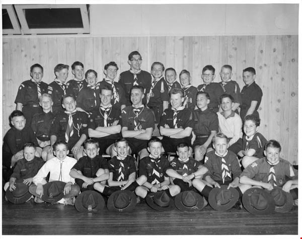
Troup photographs
https://search.heritageburnaby.ca/link/archivedescription55157
- Repository
- City of Burnaby Archives
- Date
- 1969-1975
- Collection/Fonds
- Burnaby Historical Society fonds
- Description Level
- File
- Physical Description
- 16 photographs : b&w and col. ; 18 cm x 23 cm and smaller
- Scope and Content
- Group portraits of various Boy Scout troops including: 1st Southview Cub Pack, 5th Burnaby West, 5th Burnaby Heights Troop, 5th Burnaby West Nootka Wolf Cub Pack, and 7th West Cubs. The portrait of 1st Southview Cub Pack is adhered to paper along with a green and red Boy Scouts badge. File also i…
- Repository
- City of Burnaby Archives
- Date
- 1969-1975
- Collection/Fonds
- Burnaby Historical Society fonds
- Subseries
- Burnaby Scouts subseries
- Physical Description
- 16 photographs : b&w and col. ; 18 cm x 23 cm and smaller
- Description Level
- File
- Record No.
- 631-039
- Access Restriction
- No restrictions
- Reproduction Restriction
- Reproduce for fair dealing purposes only
- Accession Number
- BHS1994-05
- Scope and Content
- Group portraits of various Boy Scout troops including: 1st Southview Cub Pack, 5th Burnaby West, 5th Burnaby Heights Troop, 5th Burnaby West Nootka Wolf Cub Pack, and 7th West Cubs. The portrait of 1st Southview Cub Pack is adhered to paper along with a green and red Boy Scouts badge. File also includes photographs of Scouts and leaders participating in activities including camping and rock climbing and one photograph of Cub Scouts meeting Queen Elizabeth II.
- Names
- Boy Scouts of Canada
- Media Type
- Photograph
- Notes
- Photographer's stamp on verso of photograph 631-039-1 reads: "William Stanley Photographer [contact information]"
- Note in pencil on verso of 631-039-2 reads: "1st Southview"
- Identification key for 631-039-3 located in accession file. Key titled "Boy Scouts of Canada 5th Burnaby West 1974-1975"
- Identification key for 631-039-5 located in accession file. Key titled "Geological Tour - U.S. Sept. 4-5-6, 1971 / 5th Burnaby Heights Troop - taken at "Summer Falls, Wash."
- Identification key attached to 631-039-6. Key titled "Boy Scouts of Canada 5th Burnaby West / 1972-1973"
- Identification key attached to 631-039-7. Key titled "Boy Scouts of Canada 5th Burnaby West / 1974-1975"
- Identification key for 631-039-8 located in accession file. Key titled "Boy Scouts of Canada 5th Burnaby West Nootka Wolf Cub Pack / 1972-1973"
- Note in blue ink on recto of 631-039-9 reads: "5th Burnaby West 1974-1975"
- Identification key for 631-039-10 located in accession file. Key titled "7th West Cubs"
- Photographer's stamp on verso of 631-03-11 reads: "Vancouver Sun Photo Copyright further publication forbidden without permission"
- Sticky note adhered to verso of 631-036-12 read: "Camp Byng".
- Note in pencil on verso of 631-039-14 reads: "Christmas 1969 / Burnie Short June Kinnear Betty Forbes"
Images
Vera Armstrong scrapbook
https://search.heritageburnaby.ca/link/museumdescription4586
- Repository
- Burnaby Village Museum
- Date
- 1960-1970 (date of original), copied 2016
- Collection/Fonds
- Burnaby Girl Guides fonds
- Description Level
- File
- Physical Description
- 1 scrapbook (2 digital files : (pdf) + 58 photographs : col. (tiffs) + 58 photographs)
- Scope and Content
- File consists of images of a scrapbook that was created by Vera Armstrong during her involvement with the Burnaby Girl Guides. The scrapbook is composed mostly of photographs along with a few newspaper clippings, correspondence and ephemera about Guiding and camps. Both originals and copies of than…
- Repository
- Burnaby Village Museum
- Collection/Fonds
- Burnaby Girl Guides fonds
- Description Level
- File
- Physical Description
- 1 scrapbook (2 digital files : (pdf) + 58 photographs : col. (tiffs) + 58 photographs)
- Scope and Content
- File consists of images of a scrapbook that was created by Vera Armstrong during her involvement with the Burnaby Girl Guides. The scrapbook is composed mostly of photographs along with a few newspaper clippings, correspondence and ephemera about Guiding and camps. Both originals and copies of thank you letters from various organizations regarding donations are included. Much of the photograph collection is described as outings and events such as; hiking on Burnaby Mountain, visiting a sheep farm in Ladner, Stanley Park, Wilson Creek and camps with various themes, a Powell Church service, a Winter Camp and a visit to the Parthenon in West Vancouver (built by resident Nick Kogo in the 1960s and demolished or moved sometime in the 1990s).
- Creator
- Armstrong, Vera
- Accession Code
- BV015.35.158
- Access Restriction
- No restrictions
- Reproduction Restriction
- May be restricted by third party rights
- Date
- 1960-1970 (date of original), copied 2016
- Media Type
- Photograph
- Textual Record
- Notes
- Title based on contents of file
- Digital images were created of the scrapbook prior to selective retention of original records that were removed for conservation purposes
- Three photographs from scrapbook have been retained and described at item level (BV015.35.189, BV015.35.190 and BV015.35.255)
- Other photographs have been retained under file BV015.35.158 (no item level descriptions)
Images

Documents
Water Supply
https://search.heritageburnaby.ca/link/councilreport32112
- Repository
- City of Burnaby Archives
- Report ID
- 24538
- Meeting Date
- 9-Mar-1970
- Format
- Council - Manager's Report
- Manager's Report No.
- 15
- Item No.
- 14
- Collection/Fonds
- City Council and Office of the City Clerk fonds
- Repository
- City of Burnaby Archives
- Report ID
- 24538
- Meeting Date
- 9-Mar-1970
- Format
- Council - Manager's Report
- Manager's Report No.
- 15
- Item No.
- 14
- Collection/Fonds
- City Council and Office of the City Clerk fonds
Documents
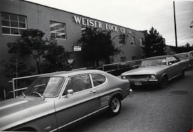
Weiser Lock Company
https://search.heritageburnaby.ca/link/archivedescription79359
- Repository
- City of Burnaby Archives
- Date
- September 22, 1976
- Collection/Fonds
- Burnaby Public Library Contemporary Visual Archive Project
- Description Level
- Item
- Physical Description
- 1 photograph : b&w ; 11 x 16 cm mounted on cardboard
- Scope and Content
- Photograph shows Weiser Lock Company Ltd. which was started in Vancouver in 1954. The plant pictured in the photograph, at 6700 Beresford Street, was constructed in 1954. The building expanded 12 times between 1954 and the time of the photograph in 1976, from the original 10,000 to 350,000 square…
- Repository
- City of Burnaby Archives
- Date
- September 22, 1976
- Collection/Fonds
- Burnaby Public Library Contemporary Visual Archive Project
- Physical Description
- 1 photograph : b&w ; 11 x 16 cm mounted on cardboard
- Description Level
- Item
- Record No.
- 556-266
- Access Restriction
- No restrictions
- Reproduction Restriction
- Reproduce for fair dealing purposes only
- Accession Number
- 2013-13
- Scope and Content
- Photograph shows Weiser Lock Company Ltd. which was started in Vancouver in 1954. The plant pictured in the photograph, at 6700 Beresford Street, was constructed in 1954. The building expanded 12 times between 1954 and the time of the photograph in 1976, from the original 10,000 to 350,000 square feet and was the only Weiser Lock plant in Canada.
- Subjects
- Buildings - Industrial
- Media Type
- Photograph
- Photographer
- Ross, Martha
- Notes
- Scope note taken directly from BPL photograph description.
- 1 b&w copy negative : 10 x 12.5 cm accompanying
- Geographic Access
- Beresford Street
- Street Address
- 6700 Beresford Street
- Historic Neighbourhood
- Edmonds (Historic Neighbourhood)
- Planning Study Area
- Kingsway-Beresford Area
Images

William John Beamish genealogical records
https://search.heritageburnaby.ca/link/archivedescription100656
- Repository
- City of Burnaby Archives
- Date
- 1861-1942
- Collection/Fonds
- William Randolph Beamish fonds
- Description Level
- File
- Physical Description
- 0.5 cm. of textual records and 1 large b&w print.
- Scope and Content
- File consists of family history records related to the Beamishes, William Randolph Beamish's adopted family, including a letter certifying the birth and baptism of William John Beamish on December 13, 1860, and June 9, 1861, respectively; a certificate for William John Beamish for the Probationers'…
- Repository
- City of Burnaby Archives
- Date
- 1861-1942
- Collection/Fonds
- William Randolph Beamish fonds
- Physical Description
- 0.5 cm. of textual records and 1 large b&w print.
- Description Level
- File
- Record No.
- 66674
- Access Restriction
- No restrictions
- Accession Number
- 2023-03
- Scope and Content
- File consists of family history records related to the Beamishes, William Randolph Beamish's adopted family, including a letter certifying the birth and baptism of William John Beamish on December 13, 1860, and June 9, 1861, respectively; a certificate for William John Beamish for the Probationers' Course of Study of the Methodist Church of Canada; sermon notes written by W.J. Beamish, as well as "his life as he wrote it”; a financial statement of Newington Circuit; his ordination picture; and obituaries for W.J. Beamish.
- History
- William John Beamish was born in Prescott, Ontario, on December 30, 1860. He was brought up and confirmed in the Anglican Church. While in his teens, he was attending a Methodist Church, became converted, and entered the same church as a candidate for the ministry. His probationary years were spent in the Northern Ontario lumber camps, ministering to the men on Lake Tallon Mission and Nipissing Junction. Mr. Beamish attended McGill College and after ordination at Smiths Falls, Ontario, on June 2, 1896, was appointed to Locksley circuit near Pembroke, then followed pastorates at Hammon, Mille Roches, Moulinette, Morewood, and Berwick. In 1905, while at Morewood, he married Miss Agnes Crabbe, a nurse from Ottawa, formerly Pembroke. Together, they served Wakefield, Quebec, Newington, and Easton's Corners, Ontario. Coming to British Columbia in 1911, they settled first at Kaslo, then Salmon Arm, Vancouver (Dundas), and Maple Ridge. In 1918, Mr. Beamish superannuated and bought a home in Burnaby where he resided until his death on July 26, 1942. During his period of superannuation, Mr. Beamish served for about seven years as minister of East Burnaby Methodist Church and until his death, was a valued member of this congregation, now known as East Burnaby United. He was ever a true friend of the minister and his presence in the congregation was an inspiration. While in good health, he gave his time freely to sick visitation and, in a word, "he went about doing good." Funeral services were conducted by Rev. W.R. Walkinshaw, with Rev. H.E. Horton representing Westminster Presbyterian assisting. Four retired ministers and two laymen acted as pall bearers. His reamins lie in Forest Lawn Memorial Park. He was survived by his wife; one son, Randolph; two daughters, Ethel (Mrs. Paul B. Derrick) and Ilma (Mrs. William Dunn). He was a good husband, a loving father, a dutiful son, and a faithful minister of the Gospel. -- This text was composed and written by Rev. R.W. Walkinshaw and later published in The Observer, the United Church magazine. It has been lightly edited here for grammar and punctuation.
- Media Type
- Textual Record
Yanko family album
https://search.heritageburnaby.ca/link/archivedescription74511
- Repository
- City of Burnaby Archives
- Date
- 1956-1979
- Collection/Fonds
- Yanko family fonds
- Description Level
- File
- Physical Description
- 1 album (613 photographs : col.)
- Scope and Content
- Photographic album documenting John Ivan Yanko and Leida Doria "Lillian Doris" (Carman) Yanko and their two daughters, Rhonda and Charmaine (later Bayntun). Photographs depict family parties and events, travel snapshots, scenes in Vancouver, and the family home and pets.
- Repository
- City of Burnaby Archives
- Date
- 1956-1979
- Collection/Fonds
- Yanko family fonds
- Physical Description
- 1 album (613 photographs : col.)
- Description Level
- File
- Record No.
- 545-249
- Access Restriction
- No restrictions
- Reproduction Restriction
- No restrictions
- Accession Number
- 2012-09
- Scope and Content
- Photographic album documenting John Ivan Yanko and Leida Doria "Lillian Doris" (Carman) Yanko and their two daughters, Rhonda and Charmaine (later Bayntun). Photographs depict family parties and events, travel snapshots, scenes in Vancouver, and the family home and pets.
- Subjects
- Celebrations - Birthdays
- Celebrations
- Travel
- Names
- Yanko, Leida Doria "Lillian Doris" Carman
- Yanko, John Ivan
- Yanko, Rhonda
- Bayntun, Charmaine "Sherrie" Yanko
- Media Type
- Photograph
- Notes
- Title based on contents of file
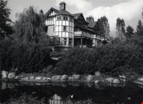
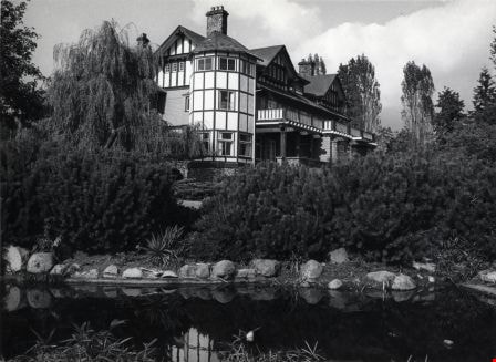
Burnaby Art Gallery
https://search.heritageburnaby.ca/link/archivedescription79804
- Repository
- City of Burnaby Archives
- Date
- October, 1976
- Collection/Fonds
- Burnaby Public Library Contemporary Visual Archive Project
- Description Level
- Item
- Physical Description
- 1 photograph : b&w ; 11 x 16 cm mounted on cardboard
- Scope and Content
- Photograph shows the Burnaby Art Gallery at 6344 Gilpin Street (later 6344 Deer Lake Avenue). Built in 1908 by R. P. Twizell as the private residence of Henry Ceperley. For a time, it was the home of Vancouver's former Mayor Buscombe. In 1940 it was occupied by the Order of Benedictine and later…
- Repository
- City of Burnaby Archives
- Date
- October, 1976
- Collection/Fonds
- Burnaby Public Library Contemporary Visual Archive Project
- Physical Description
- 1 photograph : b&w ; 11 x 16 cm mounted on cardboard
- Description Level
- Item
- Record No.
- 556-441
- Access Restriction
- No restrictions
- Reproduction Restriction
- Reproduce for fair dealing purposes only
- Accession Number
- 2013-13
- Scope and Content
- Photograph shows the Burnaby Art Gallery at 6344 Gilpin Street (later 6344 Deer Lake Avenue). Built in 1908 by R. P. Twizell as the private residence of Henry Ceperley. For a time, it was the home of Vancouver's former Mayor Buscombe. In 1940 it was occupied by the Order of Benedictine and later became the communal dwelling of the Canadian Temple of the Universal Foundation of More Abundant Life. The conversion of the estate to a cultural centre was Burnaby's centennial project and the first art show was held in June 1967.
- Subjects
- Buildings - Civic - Art Galleries
- Names
- Burnaby Art Gallery
- Media Type
- Photograph
- Photographer
- Salmon, Stu
- Notes
- Scope note taken directly from BPL photograph description.
- 1 b&w copy negative : 10 x 12.5 cm accompanying
- Geographic Access
- Deer Lake Avenue
- Gilpin Street
- Street Address
- 6344 Deer Lake Avenue
- 6344 Gilpin Street
- Historic Neighbourhood
- Burnaby Lake (Historic Neighbourhood)
- Planning Study Area
- Douglas-Gilpin Area
Images
City of Vancouver's Bylaw for the Control of Untidy Premises
https://search.heritageburnaby.ca/link/councilreport24954
- Repository
- City of Burnaby Archives
- Report ID
- 18898
- Meeting Date
- 3-Nov-1975
- Format
- Council - Manager's Report
- Manager's Report No.
- 70
- Item No.
- 4
- Collection/Fonds
- City Council and Office of the City Clerk fonds
- Repository
- City of Burnaby Archives
- Report ID
- 18898
- Meeting Date
- 3-Nov-1975
- Format
- Council - Manager's Report
- Manager's Report No.
- 70
- Item No.
- 4
- Collection/Fonds
- City Council and Office of the City Clerk fonds
Documents
Harold H. Johnston fonds
https://search.heritageburnaby.ca/link/archivedescription47202
- Repository
- City of Burnaby Archives
- Date
- 1958-1983
- Collection/Fonds
- Harold H. Johnston fonds
- Description Level
- Fonds
- Physical Description
- 106 photographs (jpeg) : b&w
- Scope and Content
- Fonds consists of 106 photographs depicting locations in Burnaby and its environs.
- Repository
- City of Burnaby Archives
- Date
- 1958-1983
- Collection/Fonds
- Harold H. Johnston fonds
- Physical Description
- 106 photographs (jpeg) : b&w
- Description Level
- Fonds
- Access Restriction
- Open access
- Reproduction Restriction
- May be restricted by third party rights
- Accession Number
- 2008-08
- Scope and Content
- Fonds consists of 106 photographs depicting locations in Burnaby and its environs.
- History
- Harold Henry (Hal) Johnston (September 15, 1930 - January 15, 1985) was born in Ardreagh, Northern Ireland, trained as a plasterer, and immigrated to Canada in 1951. Settling in Edmonton in 1952, he married Frances Henriette Coulombe (born July 29, 1932) in June 1955. He worked as a plasterer in Edmonton until late 1957, when they moved to Burnaby, British Columbia. They purchased, renovated and occupied 4447 Venables Street. They had two children, Sean Francois Johnston (born October 30, 1956) and Wendy Marie Johnston (born October 9, 1959). In Burnaby, they attended Holy Cross Primary School (1450 Delta Avenue), Alpha Secondary School (4600 Parker Street) and Simon Fraser University, later completing PhDs at the University of Leeds and Universite de Montreal, respectively. Harold Johnston continued to work as a plasterer, serving in 1969 as business agent for the Plasterers' and Stonemasons' Union, and then self-employed as A&H Plastering and Stucco from 1970 until his death in 1985. Frances Johnston worked part-time as secretary for Holy Cross parish rectory. Harold Johnston was a serious photographer and camera collector, recording some 1500 rolls of black and white slide film in 35mm and other formats on a variety of cameras from the early 1950s until 1984, mainly of locations in the Lower Mainland and Pacific Northwest. From 1960, he processed and printed the negatives himself in a home darkroom. From 1970, Johnston recorded a number of artists, illustrators and sculptors working in Vancouver's downtown eastside, notably Wil Hudson (fine printer and typographer), Keith Shields (sculptor), Frits Jacobsen (illustrator), Charles Butler (wood sculptor) and Bill Shoebotham (primitive artist). **This biographical sketch was based on information prepared by Dr. Sean Johnston and provided to the City of Burnaby Archives in April 2008.**
- Media Type
- Photograph
- Creator
- Johnston, Harold H.
Rail classics, vol. 2, no. 2
https://search.heritageburnaby.ca/link/museumlibrary1387
- Repository
- Burnaby Village Museum
- Collection
- Reference Collection
- Material Type
- Textual Record
- Call Number
- 388.46 RAI v. 2, no. 2
- Place of Publication
- Canoga Park, Calif.
- Publisher
- Challenge Publication Inc.
- Publication Date
- 1973
- Physical Description
- 82 p. : ill ; 28 cm.
- Library Subject (LOC)
- Transportation
- Electric railroads
- Local transit
- Street-railroads
- British Columbia--History
- Notes
- "Commuting in British Columbia, Vancouver's British Columbia Electric Railway was the Canadian Equivalent of the Sprawling Pacific Electric by Ira L. Swett" -- page 40 - 45.
- Details about the "Districts of Interurban line plus descriptions of different interurban cars operating in the system.