Narrow Results By
Decade
- 2020s
- 2010s 5
- 2000s 106
- 1990s 88
- 1980s 22
- 1970s 305
- 1960s 73
- 1950s
- 1940s 60
- 1930s 53
- 1920s 88
- 1910s 65
- 1900s
- 1890s 10
- 1880s 2
- 1870s 1
- 1860s 2
- 1850s 1
- 1840s 1
- 1830s 1
- 1820s 1
- 1810s 1
- 1800s 1
- 1790s 1
- 1780s 1
- 1770s 1
- 1760s 1
- 1750s 1
- 1740s 1
- 1730s 1
- 1720s 1
- 1710s
- 1700s 1
- 1690s 1
- 1680s 1
- 1670s 1
- 1660s 1
- 1650s 1
- 1640s 1
- 1630s 1
- 1620s 1
- 1610s 1
- 1600s 1

Burnaby Central School
https://search.heritageburnaby.ca/link/landmark814
- Repository
- Burnaby Heritage Planning
- Geographic Access
- Canada Way
- Associated Dates
- 1958
- Heritage Value
- Burnaby Central School became the third high school to be built in Burnaby (following Burnaby North and Burnaby South). The increased school enrolments due to the rapidly growing population in Burnaby meant that the School District required this third high school to be placed between the other two. In its first year, 719 students attended Burnaby Central.
- Historic Neighbourhood
- Burnaby Lake (Historic Neighbourhood)
- Planning Study Area
- Douglas-Gilpin Area
- Street Address
- 4939 Canada Way
- Street View URL
- Google Maps Street View
Images


Burnaby Municipal Hall
https://search.heritageburnaby.ca/link/landmark807
- Repository
- Burnaby Heritage Planning
- Geographic Access
- Canada Way
- Associated Dates
- 1956
- Heritage Value
- When staff outgrew the municipal buildings at Edmonds and Kingsway, a debate erupted over where to build a new municipal hall. North Burnaby residents argued against the Kingsway and Edmonds site as it was too removed for their needs, but South Burnaby residents were not prepared to accept a hall in North Burnaby. The debate was finally resolved when it was suggested that the new civic centre for the municipality be in the exact geographic centre of Burnaby. Fortunately, this meant that the new hall was to be built near Deer Lake, in the beautiful Central Valley setting. Burnaby voters accepted this decision and approved the $625,000.00 it would take to build the new structure and the official opening ceremony was held June 22, 1956 when then Reeve Charles MacSorley received the keys to the hall from the contractor.
- Historic Neighbourhood
- Burnaby Lake (Historic Neighbourhood)
- Planning Study Area
- Douglas-Gilpin Area
- Street Address
- 4949 Canada Way
- Street View URL
- Google Maps Street View
Images


Burnaby Winter Club
https://search.heritageburnaby.ca/link/landmark816
- Repository
- Burnaby Heritage Planning
- Geographic Access
- Canada Way
- Associated Dates
- 1956
- Heritage Value
- Skating on Deer Lake and Burnaby Lake was the inspiration to form the Burnaby Winter Club in the 1950s. In 1958, the volunteer group opened an indoor ice facility, still operating today at 4990 Canada Way. Originally, the facility boasted 8 sheets of curling ice, that were used to capacity by the more than 500 family and individual members in the heyday of the Club. The Winter Club was a social centre: in addition to curling, it was a popular place for banquets and dances, and a place for families to spend time together. In the 1960s, the eight sheets of curling ice were reduced to five, to make room for a sheet of hockey ice for the members’ children. Volunteer coaches were committed to excellence, and the Club produced many professional hockey players. By 1964, the Club’s first future NHL player was playing: Pee Wee player Jack McIlhargey.
- Historic Neighbourhood
- Burnaby Lake (Historic Neighbourhood)
- Planning Study Area
- Douglas-Gilpin Area
- Street Address
- 4990 Canada Way
- Street View URL
- Google Maps Street View
Images


Douglas-Gilpin Neighbourhood
https://search.heritageburnaby.ca/link/landmark799
- Repository
- Burnaby Heritage Planning
- Associated Dates
- 1955-2008
- Heritage Value
- The Douglas-Gilpin Neighbourhood developed into a diverse area incorporating residential, business, educational and park districts in the period after 1955. The BCIT site was built in the early 1960s, shortly after the Burnaby Municipal Hall was located on Canada Way near Deer Lake in 1956. The construction of the Municipal Hall at this location fostered the creation of an administrative and business centre adjacent to the park, while the northern and central areas of the neighbourhood retained their primarily residential character.
- Historic Neighbourhood
- Burnaby Lake (Historic Neighbourhood)
- Planning Study Area
- Douglas-Gilpin Area
Images


Douglas Road School
https://search.heritageburnaby.ca/link/landmark754
- Repository
- Burnaby Heritage Planning
- Geographic Access
- Canada Way
- Associated Dates
- 1908
- Heritage Value
- This school was the fifth to open in Burnaby and was initially known as Lake View School. In 1913, names of Burnaby Schools were changed to reflect their location and thus Lake View became Douglas Road. The first building on the site was torn down in the 1950s but the main building, which was constructed in 1928, remains although it had additions and renovations done in 1950, 1954, 1960, 1961, 1967 and 1973.
- Historic Neighbourhood
- Burnaby Lake (Historic Neighbourhood)
- Planning Study Area
- Douglas-Gilpin Area
- Street Address
- 4861 Canada Way
- Street View URL
- Google Maps Street View
Images


H.T. Ceperley Estate 'Fairacres' Greenhouse Foundation Wall
https://search.heritageburnaby.ca/link/landmark862
- Repository
- Burnaby Heritage Planning
- Description
- The original rubble stone walls that formed the foundation for a greenhouses adjacent to the Steam Plant Building provided heat to several greenhouses on the estate propoerty. The Root House, which is to the north of the Greenhouse Foundation Wall, provided storage for the farm operation.
- Associated Dates
- 1908
- Formal Recognition
- Heritage Designation, Community Heritage Register
- Repository
- Burnaby Heritage Planning
- Geographic Access
- Deer Lake Avenue
- Associated Dates
- 1908
- Formal Recognition
- Heritage Designation, Community Heritage Register
- Enactment Type
- Bylaw No. 140665
- Enactment Date
- 23/11/1992
- Description
- The original rubble stone walls that formed the foundation for a greenhouses adjacent to the Steam Plant Building provided heat to several greenhouses on the estate propoerty. The Root House, which is to the north of the Greenhouse Foundation Wall, provided storage for the farm operation.
- Heritage Value
- The outbuildings at 'Fairacres' are a rare surviving architecturally-designed ensemble of agricultural structures that exist in complementary harmony with the main estate house. Architect Robert Mackay Fripp (1858-1917), an outspoken advocate of Arts and Crafts design, was retained by the Ceperleys to design several original outbuildings on their estate, which was designed as a country estate with a working farm that included over 10 acres of productive berry and vegetable fields, with a large kitchen garden, a root house to store food, an orchard, and greenhouses heated by steam. The agricultural potential of the Deer Lake area made it one of the first parts of the municipality to attract settlement. In 1909, the Ceperleys built three large greenhouses heated by an adjacent steam plant (Fairacres Steam Plant). The greenhouses featured granite foundation walls, including this one which remains intact. The Ceperleys employed a large staff to manage the estate's agricultural production, including Chinese farm labourers. Produce was grown for use at the estate, and for sale at local markets. Agricultural use of the estate continued when a Catholic order of Benedictine monks purchased the estate as part of the Priory of St. Joseph and the Seminary of Christ the King, and continued to farm the land until 1953.
- Defining Elements
- Key elements that define the heritage character of the ‘Fairacres’ Steam Plant Building include its: - overall spatial arrangement of the Greenhouse Foundation Wall in relation to the Steam Plant Building and the Root House - original rubble stone walls reflecting the Arts and Crafts design aesthetic of the estate buildings.
- Locality
- Deer Lake Park
- Historic Neighbourhood
- Burnaby Lake (Historic Neighbourhood)
- Planning Study Area
- Douglas-Gilpin Area
- Architect
- Robert Mackay Fripp
- Function
- Primary Historic--Outbuilding
- Community
- Burnaby
- Cadastral Identifier
- P.I.D. No. 004-493-311 Legal Description: Block 3 Except: Part subdivided by Plan 26865, District Lot 79, Group 1, New Westminster District, Plan 536
- Boundaries
- ‘Fairacres’ is comprised of a single municipally-owned property located at 6344 Deer Lake Avenue, Burnaby.
- Area
- 17,065.00
- Contributing Resource
- Landscape Feature
- Remains
- Ownership
- Public (local)
- Other Collection
- Burnaby Historical Society, Community Archives: Ceperley Photograph Album
- Documentation
- Heritage Site Files: PC77000 20. City of Burnaby Planning and Building Department, 4949 Canada Way, Burnaby, B.C., V5G 1M2
- Street Address
- 6344 Deer Lake Avenue
Images


H.T. Ceperley Estate 'Fairacres' Root House
https://search.heritageburnaby.ca/link/landmark527
- Repository
- Burnaby Heritage Planning
- Description
- The ‘Fairacres’ Root House is a long, low one-storey masonry building, measuring 4.6 metres by 9.1 metres, with massively buttressed concrete walls and foundations. Built into sloping ground adjacent to the location of the former greenhouses, the surviving orchard and the kitchen entrance of the ma…
- Associated Dates
- 1908
- Formal Recognition
- Heritage Designation, Community Heritage Register
- Repository
- Burnaby Heritage Planning
- Geographic Access
- Deer Lake Avenue
- Associated Dates
- 1908
- Formal Recognition
- Heritage Designation, Community Heritage Register
- Enactment Type
- Bylaw No. 9807
- Enactment Date
- 23/11/1992
- Description
- The ‘Fairacres’ Root House is a long, low one-storey masonry building, measuring 4.6 metres by 9.1 metres, with massively buttressed concrete walls and foundations. Built into sloping ground adjacent to the location of the former greenhouses, the surviving orchard and the kitchen entrance of the main house, 'Fairacres,' this functional structure was used as a frost-free store for fruit and vegetables for the family's use.
- Heritage Value
- The outbuildings at 'Fairacres' are a rare surviving architecturally-designed ensemble of agricultural structures that exist in complementary harmony with the main estate house. Architect Robert Mackay Fripp (1858-1917), an outspoken advocate of Arts and Crafts design, was retained by the Ceperleys to design several original outbuildings on their estate. The Root House is important as a rare surviving, and exceptionally large, example of this building type in the Vancouver region. Unusual in the fact that an architect designed a building of such modest aspirations, it is also remarkable in its method of construction. The use of concrete as a structural material is one of the earliest in the region and extraordinary for its use on such a modest vernacular outbuilding; root cellars were typically built of loose stone. Built in 1908, the Root House was significantly altered in the 1960s and restored to its original design in 2000. The building is significant as an indicator of the market gardening activity in the area around Deer Lake and of the country-house self-sufficiency practiced by the Ceperley family. The Root House illustrates the cultural, aesthetic, and lifestyle values of the Ceperleys in constructing such a large building for storing their own produce.
- Defining Elements
- The outbuildings at 'Fairacres' are a rare surviving architecturally-designed ensemble of agricultural structures that exist in complementary harmony with the main estate house. Architect Robert Mackay Fripp (1858-1917), an outspoken advocate of Arts and Crafts design, was retained by the Ceperleys to design several original outbuildings on their estate. The Root House is important as a rare surviving, and exceptionally large, example of this building type in the Vancouver region. Unusual in the fact that an architect designed a building of such modest aspirations, it is also remarkable in its method of construction. The use of concrete as a structural material is one of the earliest in the region and extraordinary for its use on such a modest vernacular outbuilding; root cellars were typically built of loose stone. Built in 1908, the Root House was significantly altered in the 1960s and restored to its original design in 2000. The building is significant as an indicator of the market gardening activity in the area around Deer Lake and of the country-house self-sufficiency practiced by the Ceperley family. The Root House illustrates the cultural, aesthetic, and lifestyle values of the Ceperleys in constructing such a large building for storing their own produce.
- Locality
- Deer Lake Park
- Historic Neighbourhood
- Burnaby Lake (Historic Neighbourhood)
- Planning Study Area
- Douglas-Gilpin Area
- Architect
- Robert Mackay Fripp
- Function
- Primary Historic--Outbuilding
- Secondary Historic--Food Storage
- Community
- Burnaby
- Cadastral Identifier
- P.I.D. No. 004-493-311 Legal Description: Block 3 Except: Part subdivided by Plan 26865, District Lot 79, Group 1, New Westminster District, Plan 536
- Boundaries
- ‘Fairacres’ is comprised of a single municipally-owned property located at 6344 Deer Lake Avenue, Burnaby.
- Area
- 17,065.00
- Contributing Resource
- Building
- Landscape Feature
- Ownership
- Public (local)
- Other Collection
- Burnaby Historical Society, Community Archives: Ceperley Photograph Album
- Documentation
- Heritage Site Files: PC77000 20. City of Burnaby Planning and Building Department, 4949 Canada Way, Burnaby, B.C., V5G 1M2
- Street Address
- 6344 Deer Lake Avenue
Images


H.T. Ceperley Estate 'Fairacres' Steam Plant Building
https://search.heritageburnaby.ca/link/landmark528
- Repository
- Burnaby Heritage Planning
- Description
- Designed in the British Arts and Crafts style, the ‘Fairacres’ Steam Plant Buiding is a single-storey wood frame building with a gabled roof that originally housed the apparatus for climate control in the greenhouses, formerly located to its north. The original rubble stone walls that formed the fo…
- Associated Dates
- 1908
- Formal Recognition
- Heritage Designation, Community Heritage Register
- Repository
- Burnaby Heritage Planning
- Geographic Access
- Deer Lake Avenue
- Associated Dates
- 1908
- Formal Recognition
- Heritage Designation, Community Heritage Register
- Enactment Type
- Bylaw No. 9807
- Enactment Date
- 23/11/1992
- Description
- Designed in the British Arts and Crafts style, the ‘Fairacres’ Steam Plant Buiding is a single-storey wood frame building with a gabled roof that originally housed the apparatus for climate control in the greenhouses, formerly located to its north. The original rubble stone walls that formed the foundation for the greenhouses stand adjacent. The Steam Plant Building stands as a pendant to the Root House, which is to the north of the former greenhouses.
- Heritage Value
- The outbuildings at 'Fairacres' are a rare surviving architecturally-designed ensemble of agricultural structures that exist in complementary harmony with the main estate house. Architect Robert Mackay Fripp (1858-1917), an outspoken advocate of Arts and Crafts design, was retained by the Ceperleys to design several original outbuildings on their estate. The Ceperleys operated 'Fairacres' with staff, a farm manager and workers, including Chinese, to grow produce for themselves and for sale at local markets. The Steam Plant Building illustrates the market gardening activity of the area around Deer Lake and its importance to the Ceperley family, which valued a year-round supply of fresh fruit and vegetables for the kitchen and flowers for the house. It also illustrates the cultural and aesthetic values of the Ceperleys in retaining an architect to design a functional outbuilding using an accepted and contemporary architectural style. Built in 1908, the Steam Plant Building was significantly altered in the 1960s and restored to its original design in 2000.
- Defining Elements
- Key elements that define the heritage character of the ‘Fairacres’ Steam Plant Building include its: - overall spatial arrangement of the Steam Plant Building in relation to the former greenhouses and the Root House - side gable roof with cedar shingle cladding. - tall brick chimney indicitive of the building's original function. - distinctive Arts and Crafts architectural features such as the shingle wall cladding with decorative shingling under window sills, deep eaves, and pebble-dashed concrete foundation walls - six-paned wooden-sash casement windows - simple functional interior features - rubble stone walls that formed the foundation for the greenhouses
- Locality
- Deer Lake Park
- Historic Neighbourhood
- Burnaby Lake (Historic Neighbourhood)
- Planning Study Area
- Douglas-Gilpin Area
- Architect
- Robert Mackay Fripp
- Function
- Primary Historic--Outbuilding
- Community
- Burnaby
- Cadastral Identifier
- P.I.D. No. 004-493-311 Legal Description: Block 3 Except: Part subdivided by Plan 26865, District Lot 79, Group 1, New Westminster District, Plan 536
- Boundaries
- ‘Fairacres’ is comprised of a single municipally-owned property located at 6344 Deer Lake Avenue, Burnaby.
- Area
- 17,065.00
- Contributing Resource
- Building
- Landscape Feature
- Ownership
- Public (local)
- Other Collection
- Burnaby Historical Society, Community Archives: Ceperley Photograph Album
- Documentation
- Heritage Site Files: PC77000 20. City of Burnaby Planning and Building Department, 4949 Canada Way, Burnaby, B.C., V5G 1M2
- Street Address
- 6344 Deer Lake Avenue
Images


20th century typewriting : complete course
https://search.heritageburnaby.ca/link/museumlibrary5012
- Repository
- Burnaby Village Museum
- Collection
- Special Collection
- Material Type
- Book
- Accession Code
- BV007.2.1
- Call Number
- 652.3 LES
- Edition
- 6th ed.
- Place of Publication
- Cincinnati
- Publisher
- South-Western Publishing Co.
- Publication Date
- c1952
- Physical Description
- 340 p. : ill. : 20 x 28 cm.
- Library Subject (LOC)
- Typewriting
- Subjects
- Documentary Artifacts - Books
- Historic Neighbourhood
- Edmonds (Historic Neighbourhood)
- Burnaby Lake (Historic Neighbourhood)
- Planning Study Area
- Kingsway-Beresford Area
- Douglas-Gilpin Area
- Geographic Access
- Canada Way
- Southoaks Crescent
- Street Address
- 4939 Canada Way
- 6650 Southoaks Crescent
- Object History
- Was used by Burnaby resident Barbara Copan when she taught typing at Burnaby Central circa 1963-65. It may have originally belonged to Barbara's mother who also taught typing at Burnaby South High School circa 1957 to 1965. She mainly taught typing in night school.
- Notes
- Authors' given name and date as follows: Lessenberry, D.D. (David Daniel), 1896- Crawford, T. James (Thomas James)
Images


Anderson family
https://search.heritageburnaby.ca/link/archivedescription37440
- Repository
- City of Burnaby Archives
- Date
- 1958 (date of original), copied 1991
- Collection/Fonds
- Burnaby Historical Society fonds
- Description Level
- Item
- Physical Description
- 1 photograph : b&w ; 4.2 x 3.5 cm print on contact sheet 20.2 x 25.3 cm
- Scope and Content
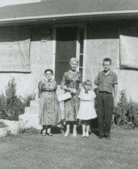
- Photograph of the Anderson family in front of the Anderson family home at 3908 Norland Avenue (previously numbered 4437 Norland Avenue). Left to right: Mrs. Anderson (grandmother), Madelaine Anderson (mother), Janet Anderson (daughter), and Cliff Anderson (son).
- Repository
- City of Burnaby Archives
- Date
- 1958 (date of original), copied 1991
- Collection/Fonds
- Burnaby Historical Society fonds
- Subseries
- Burnaby Image Bank subseries
- Physical Description
- 1 photograph : b&w ; 4.2 x 3.5 cm print on contact sheet 20.2 x 25.3 cm
- Description Level
- Item
- Record No.
- 370-028
- Access Restriction
- No restrictions
- Reproduction Restriction
- No restrictions
- Accession Number
- BHS1999-03
- Scope and Content
- Photograph of the Anderson family in front of the Anderson family home at 3908 Norland Avenue (previously numbered 4437 Norland Avenue). Left to right: Mrs. Anderson (grandmother), Madelaine Anderson (mother), Janet Anderson (daughter), and Cliff Anderson (son).
- Media Type
- Photograph
- Notes
- Title based on contents of photograph
- 1 b&w copy negative accompanying
- Geographic Access
- Norland Avenue
- Street Address
- 3908 Norland Avenue
- Historic Neighbourhood
- Burnaby Lake (Historic Neighbourhood)
- Planning Study Area
- Douglas-Gilpin Area
Images

Anderson family
https://search.heritageburnaby.ca/link/archivedescription37443
- Repository
- City of Burnaby Archives
- Date
- 1959 (date of original), copied 1991
- Collection/Fonds
- Burnaby Historical Society fonds
- Description Level
- Item
- Physical Description
- 1 photograph : b&w ; 3.9 x 4.3 cm print on contact sheet 20.2 x 25.3 cm
- Scope and Content
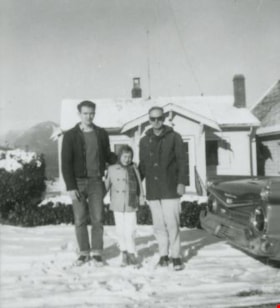
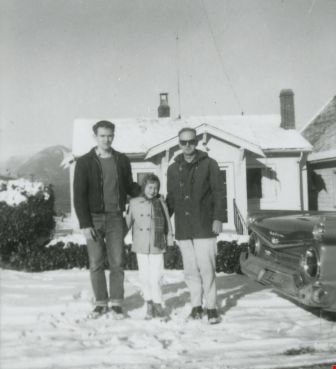
- Photograph of the Anderson family in front of their home at 3908 Norland Avenue (originally numbered 4437 Norland Avenue) after a snowfall. Left to right: Cliff Anderson (son), Janet Anderson (daughter), and Robert "Bob" Anderson (father). To the side is a 1959 Galaxie car.
- Repository
- City of Burnaby Archives
- Date
- 1959 (date of original), copied 1991
- Collection/Fonds
- Burnaby Historical Society fonds
- Subseries
- Burnaby Image Bank subseries
- Physical Description
- 1 photograph : b&w ; 3.9 x 4.3 cm print on contact sheet 20.2 x 25.3 cm
- Description Level
- Item
- Record No.
- 370-031
- Access Restriction
- No restrictions
- Reproduction Restriction
- No restrictions
- Accession Number
- BHS1999-03
- Scope and Content
- Photograph of the Anderson family in front of their home at 3908 Norland Avenue (originally numbered 4437 Norland Avenue) after a snowfall. Left to right: Cliff Anderson (son), Janet Anderson (daughter), and Robert "Bob" Anderson (father). To the side is a 1959 Galaxie car.
- Media Type
- Photograph
- Notes
- Title based on contents of photograph
- 1 b&w copy negative accompanying
- Geographic Access
- Norland Avenue
- Street Address
- 3908 Norland Avenue
- Historic Neighbourhood
- Burnaby Lake (Historic Neighbourhood)
- Planning Study Area
- Douglas-Gilpin Area
Images

A Pig's Tale
https://search.heritageburnaby.ca/link/museumdescription14365
- Repository
- Burnaby Village Museum
- Date
- Oct. 2020
- Collection/Fonds
- Burnaby Village Museum fonds
- Description Level
- Item
- Physical Description
- 3 video recordings (mp4) (5 min., 28 sec.) : digital, col., sd., stereo, subtitles
- Scope and Content
- Item consists of part two in a two part video series "A Taste of History" created by Debbie Liang and Joty Gill, University of British Columbia alumni and graduates from the Asian Canadian & Asian Migration Studies program (ACAM). Part two is titled "A Pig's Tale". The film highlights the history o…
- Repository
- Burnaby Village Museum
- Collection/Fonds
- Burnaby Village Museum fonds
- Series
- UBC Partnership series
- Description Level
- Item
- Physical Description
- 3 video recordings (mp4) (5 min., 28 sec.) : digital, col., sd., stereo, subtitles
- Material Details
- Script: Debbie Liang; Joty Gill Narration: Joty Gill Editor: Debbie Liang Subtitles: English; Simplified Chinese; Traditional Chinese Video Appearances: Kathy Lee; Eleanor Lee Illustrations and Animations: Debbie Liang Photos, Images & B-roll: Piggery photo, image courtesy of Elwin Xie; Douglas Road: City of Burnaby Archives, 477-841; Canada Way, City of Burnaby Archives, 556-522, photo by Peg Campbell; Red pig by Debbie Liang; Piglets sleeping, image courtesy of RoyBuri from pixabay, free to use; Chinese Zodiac, image courtesy of RoofOfAllLight from wikimedia, Creative Commons Attribution-Share Alike 4.0 International license; Pictograph for Home by Debbie Liang; Pigs lying down, image courtesy of Elwin Xie; Council minutes all from heritageburnaby.com; Cleanliness illustration set by Debbie Liang; "The Heathen Chinese in British Columbia" from Library and Archives Canada; Laundryman spitting from Daily News, Prince Rupert in 1911; Slicer on counter at Way Sang Yuen Wat Kee & Co., Burnaby Village Museum BV017.7.290; Way Sang Yuen Wat Kee & Co. Store front, Burnaby Village Museum BV017.7.191; Medical Practices Disagreement illustration by Debbie Liang; Butchering pig, image courtesy of Elwin Xie; Chinatown brolls, courtesy of Food2 group from UBC's 2019 ACAM 390 Class; Black Rotary telephone beside ball pen on white printed paper, image courtesy of Pixabay from pexels.com, free to use; Burnaby Lake on a cloudy day, image courtesy of Flying Pegunin from wikipedia; The Vancouver Sun May 4, 1921 from newspapers.com; Vancouver Daily May 3, 1921 from newspapers.com; Reduce number of pigs illustration by Debbie Liang; Black and white photo of piggery, image courtesy of Elwin Xie; 2019 Piggery illustration by Debbie Liang Music and Sound Effects: "Acoustic Mediation 2" from audionautix; Pig Grunting sounds from Kiddopedia Animasl, Creative Commons 0; "Piano moment" & "November" from bensound.com; "Ding sound effect" from freesoundlibrary; Wuxia2_Guzheng_Pipa by PeriTune http://peritune.com; Music promoted by https://www.free-stock-music.com; Attribution 4.0 International (CC BY 4.0) https://creativecommons.org/licenses/by/4.0/ Video adapted from 2019 BVM intern project by Debbie Liang and Marcela Gomez Special thanks to: UBC: Joanna Yang, Jenny Lu, Denise Fong, Henry Yu; BVM: Kate Petrusa, Amy Wilson Changes to music may have been made for the purposes of this video
- Scope and Content
- Item consists of part two in a two part video series "A Taste of History" created by Debbie Liang and Joty Gill, University of British Columbia alumni and graduates from the Asian Canadian & Asian Migration Studies program (ACAM). Part two is titled "A Pig's Tale". The film highlights the history of Chinese pig farms also known as "Piggeries" in Burnaby. The film tells the story of how many of these farms were established by Chinese immigrants along Douglas Road (now Canada Way) between the 1890s and 1920s; the importance of the pig in the Chinese Culture as well as a way for Chinese immigrants to make a living and the racism and discriminatory bylaws that the Chinese pig farmers suffered that finally led to the closure of many of these farms. Content references three documented piggery ranches along Douglas Road: Ah Sam; Young Chung and Hop Hin Yen. The films are supported with voice over in english, subtitles, animation along with historical photographs. One version of the film is supported with subtitles in English while two other versions of the film are supported with subtitles in Simplified Chinese and Traditional Chinese.
- History
- In 2020, due to the restrictions of COVID-19, University of British Columbia student interns with the Burnaby Village Museum Chinese Canadian History in Burnaby project were asked to create virtual experiences to reimagine Burnaby Village Museum's historical Chinese Canadian programming in remote online spaces. Debbie Liang and Joty Gill (UBC alumni and graduates of Dr. Henry Yu's 2019 summer ACAM 390A Global Seminar to Aisa) returned to work with Burnaby Village Museum to create two short films showcasing the history of Chinese Canadian Chop Suey restaurants and piggeries in Burnaby.
- Creator
- Liang, Debbie
- Debbie Liang
- Subjects
- Persons - Chinese Canadians
- Social Issues - Discrimination
- Social Issues - Racism
- Regulations
- Agriculture
- Agriculture - Farms
- Agriculture - Ranches
- Animals - Pigs
- Names
- Liang, Debbie
- Gill, Joty
- Burnaby Village Museum
- University of British Columbia
- Xie, Elwin
- Way Sang Yuen Wat Kee & Company
- Ah Sam
- Young Chung
- Hop Hin Yen
- Responsibility
- University of British Columbia
- UBC Initiative for Student Teaching and Research in Chinese Canadian Studies
- Burnaby Village Museum
- Geographic Access
- Douglas Road
- Canada Way
- Accession Code
- BV020.28.7
- Access Restriction
- No restrictions
- Reproduction Restriction
- No known restrictions
- Date
- Oct. 2020
- Media Type
- Moving Images
- Historic Neighbourhood
- Burnaby Lake (Historic Neighbourhood)
- Planning Study Area
- Douglas-Gilpin Area
- Notes
- Transcribed title
Images


Video
A Pig's Tale, Oct. 2020
A Pig's Tale, Oct. 2020
https://search.heritageburnaby.ca/media/hpo/_Data/_BVM_Moving_Images/2020_0028_0007_001.mp4
The Benedictines of Westminster Priory
https://search.heritageburnaby.ca/link/archivedescription38167
- Repository
- City of Burnaby Archives
- Date
- 1951 (date of original), copied 1991
- Collection/Fonds
- Burnaby Historical Society fonds
- Description Level
- Item
- Physical Description
- 1 photograph : b&w ; 3.3 x 5.3 cm print on contact sheet 20.1 x 26.3 cm
- Scope and Content
- Photograph of an original photographic postcard of the Benedictines of Westminster Priory at Ceperley House which was funded by the Catholic Diocese beginning in 1939. There is a postmark from Merritt, British Columbia, at the top right corner.
- Repository
- City of Burnaby Archives
- Date
- 1951 (date of original), copied 1991
- Collection/Fonds
- Burnaby Historical Society fonds
- Subseries
- Burnaby Image Bank subseries
- Physical Description
- 1 photograph : b&w ; 3.3 x 5.3 cm print on contact sheet 20.1 x 26.3 cm
- Description Level
- Item
- Record No.
- 370-754
- Access Restriction
- No restrictions
- Reproduction Restriction
- No restrictions
- Accession Number
- BHS1999-03
- Scope and Content
- Photograph of an original photographic postcard of the Benedictines of Westminster Priory at Ceperley House which was funded by the Catholic Diocese beginning in 1939. There is a postmark from Merritt, British Columbia, at the top right corner.
- Subjects
- Buildings - Religious
- Buildings - Heritage
- Occupations - Clergy
- Documentary Artifacts - Postcards
- Names
- Westminster Priory
- Media Type
- Photograph
- Notes
- 1 b&w copy negative accompanying
- Negative has a pink cast
- Annotation at bottom of photograph reads, "The Benedictines of Westminster Priory, Vancouver, BC"
- Geographic Access
- Deer Lake Avenue
- Street Address
- 6344 Deer Lake Avenue
- Historic Neighbourhood
- Burnaby Lake (Historic Neighbourhood)
- Planning Study Area
- Douglas-Gilpin Area
Images

![Bernard Hill farm, [190-] (date of original), copied 1986 thumbnail](/media/hpo/_Data/_Archives_Images/_Unrestricted/204/204-789.jpg?width=280)
Bernard Hill farm
https://search.heritageburnaby.ca/link/archivedescription35929
- Repository
- City of Burnaby Archives
- Date
- [190-] (date of original), copied 1986
- Collection/Fonds
- Burnaby Historical Society fonds
- Description Level
- Item
- Physical Description
- 1 photograph : b&w ; 12.7 x 17.8 cm print
- Scope and Content
- Photograph of the Hill brothers Frank, Claude and Gerry and their pet dog riding on hay wagon on their father's farm.
- Repository
- City of Burnaby Archives
- Date
- [190-] (date of original), copied 1986
- Collection/Fonds
- Burnaby Historical Society fonds
- Subseries
- Pioneer Tales subseries
- Physical Description
- 1 photograph : b&w ; 12.7 x 17.8 cm print
- Description Level
- Item
- Record No.
- 204-789
- Access Restriction
- No restrictions
- Reproduction Restriction
- No restrictions
- Accession Number
- BHS1988-03
- Scope and Content
- Photograph of the Hill brothers Frank, Claude and Gerry and their pet dog riding on hay wagon on their father's farm.
- Subjects
- Animals - Dogs
- Transportation - Horses
- Agriculture - Crops
- Agricultural Tools and Equipment
- Media Type
- Photograph
- Notes
- Title based on contents of photograph
- Geographic Access
- Douglas Road
- Canada Way
- Street Address
- 4990 Canada Way
- Historic Neighbourhood
- Burnaby Lake (Historic Neighbourhood)
- Planning Study Area
- Douglas-Gilpin Area
Images
![Bernard Hill farm, [190-] (date of original), copied 1986 thumbnail](/media/hpo/_Data/_Archives_Images/_Unrestricted/204/204-789.jpg)
![Bernard Hill's home, [1905] thumbnail](/media/hpo/_Data/_Archives_Images/_Unrestricted/477/477-863.jpg?width=280)
Bernard Hill's home
https://search.heritageburnaby.ca/link/archivedescription39544
- Repository
- City of Burnaby Archives
- Date
- [1905]
- Collection/Fonds
- Peers Family and Hill Family fonds
- Description Level
- Item
- Physical Description
- 1 photograph : b&w ; 7.5 x 10 cm on page 21.5 x 28 cm (pasted in album)
- Scope and Content
- Photograph of the house belonging to Bernard Hill in the Burnaby Lake area on what is now Canada Way. Douglas Road runs through the foreground.
- Repository
- City of Burnaby Archives
- Date
- [1905]
- Collection/Fonds
- Peers Family and Hill Family fonds
- Physical Description
- 1 photograph : b&w ; 7.5 x 10 cm on page 21.5 x 28 cm (pasted in album)
- Description Level
- Item
- Record No.
- 477-863
- Access Restriction
- No restrictions
- Reproduction Restriction
- No known restrictions
- Accession Number
- 2007-12
- Scope and Content
- Photograph of the house belonging to Bernard Hill in the Burnaby Lake area on what is now Canada Way. Douglas Road runs through the foreground.
- Subjects
- Buildings - Residential - Houses
- Media Type
- Photograph
- Notes
- Title based on caption accompanying photograph
- Geographic Access
- Douglas Road
- Canada Way
- Street Address
- 4990 Canada Way
- Historic Neighbourhood
- Burnaby Lake (Historic Neighbourhood)
- Planning Study Area
- Douglas-Gilpin Area
Images
![Bernard Hill's home, [1905] thumbnail](/media/hpo/_Data/_Archives_Images/_Unrestricted/477/477-863.jpg)

Bob Hutton at Municipal Hall
https://search.heritageburnaby.ca/link/archivedescription37294
- Repository
- City of Burnaby Archives
- Date
- 1958
- Collection/Fonds
- Burnaby Historical Society fonds
- Description Level
- Item
- Physical Description
- 1 photograph : b&w ; 9 x 9 cm
- Scope and Content
- Photograph of a man identified as Bob Hutton outside Burnaby Municipal Hall. Two other men are visible in the picture, but neither is identified.
- Repository
- City of Burnaby Archives
- Date
- 1958
- Collection/Fonds
- Burnaby Historical Society fonds
- Subseries
- Norah Code subseries
- Physical Description
- 1 photograph : b&w ; 9 x 9 cm
- Description Level
- Item
- Record No.
- 345-015
- Access Restriction
- No restrictions
- Reproduction Restriction
- Reproduce for fair dealing purposes only
- Accession Number
- BHS1997-05
- Scope and Content
- Photograph of a man identified as Bob Hutton outside Burnaby Municipal Hall. Two other men are visible in the picture, but neither is identified.
- Subjects
- Buildings - Civic - City Halls
- Names
- Hutton, Bob
- Burnaby City Hall
- Media Type
- Photograph
- Photographer
- Code, Norah
- Notes
- Title based on contents of photograph.
- Photographs in this collection were taken and compiled by Norah Code, former editor of the "Burnaby Courier" newspaper during the course of her work for the newspaper.
- Geographic Access
- Canada Way
- Street Address
- 4949 Canada Way
- Historic Neighbourhood
- Burnaby Lake (Historic Neighbourhood)
- Planning Study Area
- Douglas-Gilpin Area
Images


Bob Hutton, outside Burnaby Municipal Hall
https://search.heritageburnaby.ca/link/archivedescription37300
- Repository
- City of Burnaby Archives
- Date
- 1958
- Collection/Fonds
- Burnaby Historical Society fonds
- Description Level
- Item
- Physical Description
- 1 photograph : b&w ; 9.5 x 14.5 cm
- Scope and Content
- Photograph of two men and one woman standing outside Burnaby Municipal Hall reading from a proclamation and addressing a fourth man who is seen to the far right holding a microphone. The microphone bears the call letters CKNW and the man holding it has been identified as Bob Hutton.
- Repository
- City of Burnaby Archives
- Date
- 1958
- Collection/Fonds
- Burnaby Historical Society fonds
- Subseries
- Norah Code subseries
- Physical Description
- 1 photograph : b&w ; 9.5 x 14.5 cm
- Description Level
- Item
- Record No.
- 345-021
- Access Restriction
- No restrictions
- Reproduction Restriction
- Reproduce for fair dealing purposes only
- Accession Number
- BHS1997-05
- Scope and Content
- Photograph of two men and one woman standing outside Burnaby Municipal Hall reading from a proclamation and addressing a fourth man who is seen to the far right holding a microphone. The microphone bears the call letters CKNW and the man holding it has been identified as Bob Hutton.
- Subjects
- Buildings - Civic - City Halls
- Names
- Hutton, Bob
- Burnaby City Hall
- Media Type
- Photograph
- Photographer
- Code, Norah
- Notes
- Photographs in this collection were taken and compiled by Norah Code, former editor of the "Burnaby Courier" newspaper during the course of her work for the newspaper.
- Geographic Access
- Canada Way
- Street Address
- 4949 Canada Way
- Historic Neighbourhood
- Burnaby Lake (Historic Neighbourhood)
- Planning Study Area
- Douglas-Gilpin Area
Images

![Burnaby Council, [1956] thumbnail](/media/hpo/_Data/_Archives_Images/_Unrestricted/204/204-803.jpg?width=280)
Burnaby Council
https://search.heritageburnaby.ca/link/archivedescription35943
- Repository
- City of Burnaby Archives
- Date
- [1956]
- Collection/Fonds
- Burnaby Historical Society fonds
- Description Level
- Item
- Physical Description
- 1 photograph : b&w ; 20.3 x 25.4 cm print
- Scope and Content
- Photograph of the Burnaby Council in chambers.
- Repository
- City of Burnaby Archives
- Date
- [1956]
- Collection/Fonds
- Burnaby Historical Society fonds
- Subseries
- Pioneer Tales subseries
- Physical Description
- 1 photograph : b&w ; 20.3 x 25.4 cm print
- Description Level
- Item
- Record No.
- 204-803
- Access Restriction
- No restrictions
- Reproduction Restriction
- Reproduce for fair dealing purposes only
- Accession Number
- BHS1988-03
- Scope and Content
- Photograph of the Burnaby Council in chambers.
- Subjects
- Officials - Alderman and Councillors
- Buildings - Civic - City Halls
- Officials - Mayors and Reeves
- Names
- Burnaby City Hall
- Media Type
- Photograph
- Photographer
- LeBlanc, Don
- Notes
- Title based on contents of photograph
- Geographic Access
- Canada Way
- Street Address
- 4949 Canada Way
- Historic Neighbourhood
- Burnaby Lake (Historic Neighbourhood)
- Planning Study Area
- Douglas-Gilpin Area
Images
![Burnaby Council, [1956] thumbnail](/media/hpo/_Data/_Archives_Images/_Unrestricted/204/204-803.jpg)

Burnaby Lake Tram #1227
https://search.heritageburnaby.ca/link/archivedescription35998
- Repository
- City of Burnaby Archives
- Date
- June 1952
- Collection/Fonds
- Burnaby Historical Society fonds
- Description Level
- Item
- Physical Description
- 1 photograph : col. ; 10 x 15 cm print
- Scope and Content
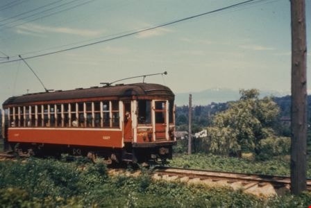
- Photograph of Tram #1227 on the Burnaby Lake Interurban line, near Murrin station.
- Repository
- City of Burnaby Archives
- Date
- June 1952
- Collection/Fonds
- Burnaby Historical Society fonds
- Subseries
- Geoff Meugans subseries
- Physical Description
- 1 photograph : col. ; 10 x 15 cm print
- Description Level
- Item
- Record No.
- 208-009
- Access Restriction
- No restrictions
- Reproduction Restriction
- Reproduce for fair dealing purposes only
- Accession Number
- BHS1988-08
- Scope and Content
- Photograph of Tram #1227 on the Burnaby Lake Interurban line, near Murrin station.
- Subjects
- Transportation - Electric Railroads
- Media Type
- Photograph
- Notes
- Title based on contents of photograph
- Geographic Access
- Burnaby Lake Interurban line
- Historic Neighbourhood
- Burnaby Lake (Historic Neighbourhood)
- Planning Study Area
- Dawson-Delta Area
- Douglas-Gilpin Area
Images
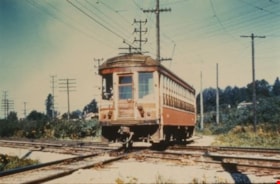
Burnaby Lake Tram #1228
https://search.heritageburnaby.ca/link/archivedescription35995
- Repository
- City of Burnaby Archives
- Date
- August 1951
- Collection/Fonds
- Burnaby Historical Society fonds
- Description Level
- Item
- Physical Description
- 1 photograph : col. ; 10 x 15 cm print
- Scope and Content
- Photograph of Tram #1228 on the Burnaby Lake Interurban line, at Ardley station, crossing Great Northern Railway tracks.
- Repository
- City of Burnaby Archives
- Date
- August 1951
- Collection/Fonds
- Burnaby Historical Society fonds
- Subseries
- Geoff Meugans subseries
- Physical Description
- 1 photograph : col. ; 10 x 15 cm print
- Description Level
- Item
- Record No.
- 208-006
- Access Restriction
- No restrictions
- Reproduction Restriction
- Reproduce for fair dealing purposes only
- Accession Number
- BHS1988-08
- Scope and Content
- Photograph of Tram #1228 on the Burnaby Lake Interurban line, at Ardley station, crossing Great Northern Railway tracks.
- Media Type
- Photograph
- Notes
- Title based on contents of photograph
- Geographic Access
- Burnaby Lake Interurban line
- Planning Study Area
- Dawson-Delta Area
- Douglas-Gilpin Area
Images
