Narrow Results By
Subject
- Agriculture - Farms 3
- Animals - Horses 1
- Buildings - Civic - City Halls 1
- Buildings - Commercial - General Stores 1
- Buildings - Commercial - Grocery Stores 2
- Buildings - Commercial - Stores 1
- Buildings - Religious 1
- Buildings - Religious - Churches 1
- Buildings - Residential - Houses 4
- Buildings - Schools 10
- Celebrations 1
- Construction 1

Captain William Eyres Residence
https://search.heritageburnaby.ca/link/landmark565
- Repository
- Burnaby Heritage Planning
- Description
- Residential building.
- Associated Dates
- c.1910
- Street View URL
- Google Maps Street View
- Repository
- Burnaby Heritage Planning
- Geographic Access
- Canada Way
- Associated Dates
- c.1910
- Description
- Residential building.
- Heritage Value
- This home was built by Captain William J. Eyres. In 1912, it was reported in The British Columbian: “Captain Eyres of Seattle is remodelling the front of his house on Douglas Road and otherwise improving it.” The house was later sold to William A. Mawhinney, who subsequently built houses at 6011 Buckingham Avenue and 7616 Burris Avenue. This spacious, high-quality Craftsman bungalow remains in excellent condition. It features a cross-gabled roof with multiple half-timbered front gables with large exposed purlins, in contrast to the shingle cladding on the rest of the house. At the front corner is a glazed sun-room. The entrance porch features tripled square columns. The property still has a beautiful garden, but once included large vegetable gardens, an orchard, and a large chicken house.
- Locality
- Burnaby Lake
- Historic Neighbourhood
- Burnaby Lake (Historic Neighbourhood)
- Planning Study Area
- Morley-Buckingham Area
- Area
- 1709.65
- Contributing Resource
- Building
- Ownership
- Private
- Street Address
- 6079 Canada Way
- Street View URL
- Google Maps Street View
Images


East Burnaby School (Edmonds Street School)
https://search.heritageburnaby.ca/link/landmark735
- Repository
- Burnaby Heritage Planning
- Geographic Access
- Canada Way
- Associated Dates
- 1894
- Heritage Value
- One of the first tasks of Burnaby's Municipal Government upon its incorporation was to lobby for a public school in Burnaby. By 1893, land on Douglas Road near Edmonds was donated and the new school was built in 1893. The one-room school opened on January 22, 1894 with 29 students under the charge of teacher, Ethel LePage. The School has been known as the Burnaby School (until1896), and then East Burnaby School from 1896 to 1907 and finally, Edmonds Street School.
- Historic Neighbourhood
- Edmonds (Historic Neighbourhood)
- Planning Study Area
- Edmonds Area
- Street Address
- 7376 Canada Way
- Street View URL
- Google Maps Street View
Images


Geoffrey & Kathleen Burnett Residence
https://search.heritageburnaby.ca/link/landmark582
- Repository
- Burnaby Heritage Planning
- Description
- Residential building.
- Associated Dates
- 1914
- Formal Recognition
- Heritage Designation, Community Heritage Register
- Street View URL
- Google Maps Street View
- Repository
- Burnaby Heritage Planning
- Geographic Access
- Canada Way
- Associated Dates
- 1914
- Formal Recognition
- Heritage Designation, Community Heritage Register
- Enactment Type
- Bylaw No. 13841
- Enactment Date
- 28/05/2018
- Description
- Residential building.
- Heritage Value
- With its long, narrow plan and hipped, cross-gabled roof, this impressive residence was designed for local surveyor and civil engineer Geoffrey Kirby Burnett, who married Kathleen Wallen (1888-1978) in 1916. It was designed by New Westminster architects R.W. Coventry Dick & Son. Beautifully conceived in the British Arts and Crafts style, it features a steeply-gabled roof over the side entry porch, with square timber columns. Other decorative details include half timbering in the gables, first storey casement windows with leaded transom lights and decorative window hoods on the side elevation.
- Locality
- Edmonds
- Historic Neighbourhood
- Edmonds (Historic Neighbourhood)
- Planning Study Area
- Richmond Park Area
- Architect
- R.W. Coventry Dick & Son
- Area
- 903.70
- Contributing Resource
- Building
- Ownership
- Private
- Street Address
- 7037 Canada Way
- Street View URL
- Google Maps Street View
Images


Lonsdale Guardhouse Residence
https://search.heritageburnaby.ca/link/landmark617
- Repository
- Burnaby Heritage Planning
- Description
- Residential building.
- Associated Dates
- 1914
- Street View URL
- Google Maps Street View
- Repository
- Burnaby Heritage Planning
- Geographic Access
- Canada Way
- Associated Dates
- 1914
- Description
- Residential building.
- Heritage Value
- The house was built by Lonsdale L. Guardhouse, who was employed with the real estate company of Merithew & Ramsay in 1912. The British Columbian reported in November 1913 that: "Mr. L.L. Guardhouse, a well-known New Westminster man has recently let the contract for a home on Douglas Road near Edmonds Street. This Building is to be erected after the bungalow style and will cost when completed about $4,000." This Craftsman style pattern-book residence is notable for its unusual roofline, which features gently curved eaves. The house remains in excellent original condition and retains its lapped and shingled siding. Other notable features of the house include its pre-cast concrete block foundation–simulated to look like cut stone–and a rustic red-brick chimney. The front verandah has been altered through the removal of its floor structure. Many houses at the time were built from Craftsman-style pattern book designs, which were readily available in magazines and brochures. This house has a twin located in New Westminster at 315 Fifth Avenue.
- Locality
- Edmonds
- Historic Neighbourhood
- Edmonds (Historic Neighbourhood)
- Planning Study Area
- Richmond Park Area
- Area
- 828.85
- Contributing Resource
- Building
- Ownership
- Private
- Street Address
- 6985 Canada Way
- Street View URL
- Google Maps Street View
Images

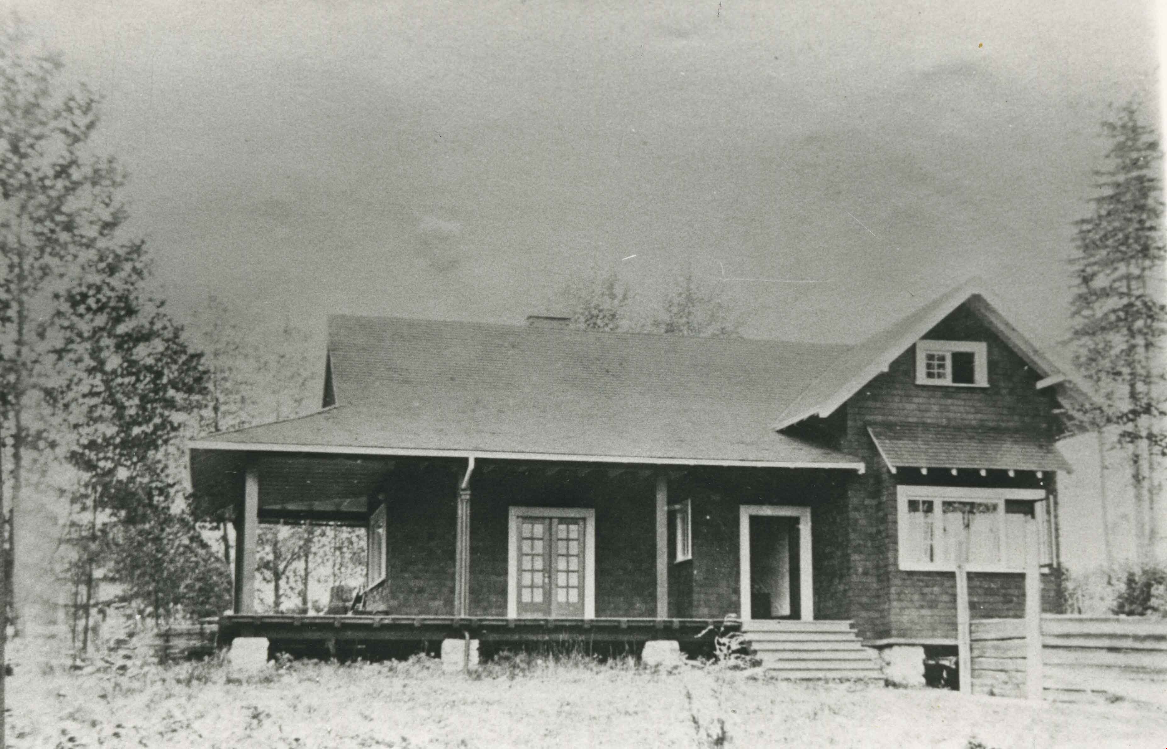
![B.R. Hill house, [1910] thumbnail](/media/hpo/_Data/_BVM_Images/1976/1976_0051_0001_001.jpg?width=280)
B.R. Hill house
https://search.heritageburnaby.ca/link/museumdescription740
- Repository
- Burnaby Village Museum
- Date
- [1910]
- Collection/Fonds
- Burnaby Village Museum Photograph collection
- Description Level
- Item
- Physical Description
- 1 photograph : b&w photogravure ; 8.1 x 10.7 cm
- Scope and Content
- Photograph is photogravure printed on paper of a house on the side of a path. The area appears wooded. The inscription and the accession register identify the house as the residence of Mr. and Mrs. B.R. Hill on Douglas Road, built about 1892, with an addition to the house built about 1905.
- Repository
- Burnaby Village Museum
- Collection/Fonds
- Burnaby Village Museum Photograph collection
- Description Level
- Item
- Physical Description
- 1 photograph : b&w photogravure ; 8.1 x 10.7 cm
- Material Details
- An annotation in pencil is written on the back of the photograph
- Scope and Content
- Photograph is photogravure printed on paper of a house on the side of a path. The area appears wooded. The inscription and the accession register identify the house as the residence of Mr. and Mrs. B.R. Hill on Douglas Road, built about 1892, with an addition to the house built about 1905.
- Subjects
- Buildings - Residential - Houses
- Geographic Access
- Canada Way
- Douglas Road
- Street Address
- 4990 Canada Way
- Accession Code
- HV976.51.1
- Access Restriction
- No restrictions
- Reproduction Restriction
- May be restricted by third party rights
- Date
- [1910]
- Media Type
- Photograph
- Historic Neighbourhood
- Burnaby Lake (Historic Neighbourhood)
- Planning Study Area
- Douglas-Gilpin Area
- Scan Resolution
- 600
- Scan Date
- 2023-06-20
- Notes
- Title based on contents of photograph
Images
![B.R. Hill house, [1910] thumbnail](/media/hpo/_Data/_BVM_Images/1976/1976_0051_0001_001.jpg)
Burnaby School House
https://search.heritageburnaby.ca/link/archivedescription34856
- Repository
- City of Burnaby Archives
- Date
- 1985
- Collection/Fonds
- Burnaby Historical Society fonds
- Description Level
- Item
- Physical Description
- 1 photograph : col. ; 8.8 x 11.4 cm
- Scope and Content
- Photograph of the exterior of the former Burnaby School building at 19th Avenue and Canada Way.
- Repository
- City of Burnaby Archives
- Date
- 1985
- Collection/Fonds
- Burnaby Historical Society fonds
- Subseries
- Evelyn Salisbury subseries
- Physical Description
- 1 photograph : col. ; 8.8 x 11.4 cm
- Description Level
- Item
- Record No.
- 145-004
- Access Restriction
- No restrictions
- Reproduction Restriction
- Reproduce for fair dealing purposes only
- Accession Number
- BHS1985-15
- Scope and Content
- Photograph of the exterior of the former Burnaby School building at 19th Avenue and Canada Way.
- Subjects
- Buildings - Schools
- Media Type
- Photograph
- Notes
- Title based on contents of photograph
- Geographic Access
- Canada Way
- Street Address
- 7376 Canada Way
- Historic Neighbourhood
- Edmonds (Historic Neighbourhood)
- Planning Study Area
- Edmonds Area
Images

Burnaby School House
https://search.heritageburnaby.ca/link/archivedescription34857
- Repository
- City of Burnaby Archives
- Date
- 1985
- Collection/Fonds
- Burnaby Historical Society fonds
- Description Level
- Item
- Physical Description
- 1 photograph : col. ; 8.8 x 11.3 cm
- Scope and Content
- Photograph of the exterior of the former Burnaby School building at 19th Avenue and Canada Way.
- Repository
- City of Burnaby Archives
- Date
- 1985
- Collection/Fonds
- Burnaby Historical Society fonds
- Subseries
- Evelyn Salisbury subseries
- Physical Description
- 1 photograph : col. ; 8.8 x 11.3 cm
- Description Level
- Item
- Record No.
- 145-005
- Access Restriction
- No restrictions
- Reproduction Restriction
- Reproduce for fair dealing purposes only
- Accession Number
- BHS1985-15
- Scope and Content
- Photograph of the exterior of the former Burnaby School building at 19th Avenue and Canada Way.
- Subjects
- Buildings - Schools
- Media Type
- Photograph
- Notes
- Title based on contents of photograph
- Geographic Access
- Canada Way
- Street Address
- 7376 Canada Way
- Historic Neighbourhood
- Edmonds (Historic Neighbourhood)
- Planning Study Area
- Edmonds Area
Images

Burnaby's first Public School
https://search.heritageburnaby.ca/link/archivedescription35881
- Repository
- City of Burnaby Archives
- Date
- February 1894 (date of original), copied 1986
- Collection/Fonds
- Burnaby Historical Society fonds
- Description Level
- Item
- Physical Description
- 1 photograph : b&w ; 12.7 x 17.8 cm print
- Scope and Content
- Photograph of school officials standing on the steps of the first public school in Burnaby, Douglas Road and Edmonds Street. Left to right: William McDermott (school trustee), Ethel Lepage (first teacher), Lancelot Grimmer (school trustee), and Bernard Hill (school board chairman and secretary). Th…
- Repository
- City of Burnaby Archives
- Date
- February 1894 (date of original), copied 1986
- Collection/Fonds
- Burnaby Historical Society fonds
- Subseries
- Pioneer Tales subseries
- Physical Description
- 1 photograph : b&w ; 12.7 x 17.8 cm print
- Description Level
- Item
- Record No.
- 204-740
- Access Restriction
- No restrictions
- Reproduction Restriction
- No known restrictions
- Accession Number
- BHS1988-03
- Scope and Content
- Photograph of school officials standing on the steps of the first public school in Burnaby, Douglas Road and Edmonds Street. Left to right: William McDermott (school trustee), Ethel Lepage (first teacher), Lancelot Grimmer (school trustee), and Bernard Hill (school board chairman and secretary). The school was called Burnaby School from 1894 to 1896, and then East Burnaby School from 1896 to 1907. The present day address of the site is 7376 Canada Way.
- Subjects
- Officials
- Occupations - Teachers
- Media Type
- Photograph
- Notes
- Title based on contents of photograph
- Geographic Access
- Canada Way
- Street Address
- 7376 Canada Way
- Historic Neighbourhood
- Edmonds (Historic Neighbourhood)
- Planning Study Area
- Edmonds Area
Images
![Douglas Road School, [between 1911 and 1919] thumbnail](/media/hpo/_Data/_Archives_Images/_Unrestricted/316/325-037.jpg?width=280)
Douglas Road School
https://search.heritageburnaby.ca/link/archivedescription37165
- Repository
- City of Burnaby Archives
- Date
- [between 1911 and 1919]
- Collection/Fonds
- Burnaby Historical Society fonds
- Description Level
- Item
- Physical Description
- 1 photograph : b&w ; 12.5 x 8 cm print
- Scope and Content
- Photograph of Douglas Road School, taken from a distance, and including the two large trees in the front playing field.
- Repository
- City of Burnaby Archives
- Date
- [between 1911 and 1919]
- Collection/Fonds
- Burnaby Historical Society fonds
- Subseries
- Disney family subseries
- Physical Description
- 1 photograph : b&w ; 12.5 x 8 cm print
- Description Level
- Item
- Record No.
- 325-037
- Access Restriction
- No restrictions
- Reproduction Restriction
- No known restrictions
- Accession Number
- BHS1996-04
- Scope and Content
- Photograph of Douglas Road School, taken from a distance, and including the two large trees in the front playing field.
- Subjects
- Buildings - Schools
- Names
- Douglas Road School
- Media Type
- Photograph
- Photographer
- Disney, John Harold "Jack"
- Notes
- Title based on contents of photograph
- Geographic Access
- Canada Way
- Street Address
- 4861 Canada Way
- Historic Neighbourhood
- Burnaby Lake (Historic Neighbourhood)
- Planning Study Area
- Douglas-Gilpin Area
Images
![Douglas Road School, [between 1911 and 1919] thumbnail](/media/hpo/_Data/_Archives_Images/_Unrestricted/316/325-037.jpg)
![Douglas Road School, [between 1911 and 1919] thumbnail](/media/hpo/_Data/_Archives_Images/_Unrestricted/316/325-038.jpg?width=280)
Douglas Road School
https://search.heritageburnaby.ca/link/archivedescription37166
- Repository
- City of Burnaby Archives
- Date
- [between 1911 and 1919]
- Collection/Fonds
- Burnaby Historical Society fonds
- Description Level
- Item
- Physical Description
- 1 photograph : b&w ; 7.5 x 12.5 cm print
- Scope and Content
- Photograph of the back of Douglas Road School, and the back field.
- Repository
- City of Burnaby Archives
- Date
- [between 1911 and 1919]
- Collection/Fonds
- Burnaby Historical Society fonds
- Subseries
- Disney family subseries
- Physical Description
- 1 photograph : b&w ; 7.5 x 12.5 cm print
- Description Level
- Item
- Record No.
- 325-038
- Access Restriction
- No restrictions
- Reproduction Restriction
- No known restrictions
- Accession Number
- BHS1996-04
- Scope and Content
- Photograph of the back of Douglas Road School, and the back field.
- Subjects
- Buildings - Schools
- Names
- Douglas Road School
- Media Type
- Photograph
- Photographer
- Disney, John Harold "Jack"
- Notes
- Title based on contents of photograph
- Geographic Access
- Canada Way
- Street Address
- 4861 Canada Way
- Historic Neighbourhood
- Burnaby Lake (Historic Neighbourhood)
- Planning Study Area
- Douglas-Gilpin Area
Images
![Douglas Road School, [between 1911 and 1919] thumbnail](/media/hpo/_Data/_Archives_Images/_Unrestricted/316/325-038.jpg)

Douglas Road School site
https://search.heritageburnaby.ca/link/museumdescription11136
- Repository
- Burnaby Village Museum
- Date
- April 19, 1915
- Collection/Fonds
- Ronald G. Scobbie collection
- Description Level
- Item
- Physical Description
- 1 survey plan : blueprint on paper ; 56 x 54 cm
- Scope and Content
- Survey plan of "Douglas Road School Site / Burnaby Municipality" "Being Lot 21, of Blocks 1-5 inc. 11 & 12 of the subd. of north half of Lot 80, Group 1, New Westminster District".
- Repository
- Burnaby Village Museum
- Collection/Fonds
- Ronald G. Scobbie collection
- Description Level
- Item
- Physical Description
- 1 survey plan : blueprint on paper ; 56 x 54 cm
- Material Details
- Scale 40 feet = 1 inch
- Scope and Content
- Survey plan of "Douglas Road School Site / Burnaby Municipality" "Being Lot 21, of Blocks 1-5 inc. 11 & 12 of the subd. of north half of Lot 80, Group 1, New Westminster District".
- Creator
- McGugan, Donald Johnston
- Subjects
- Buildings - Schools
- Names
- Douglas Road School
- Responsibility
- Burnett & McGugan, Engineers and Surveyors
- Geographic Access
- Canada Way
- Street Address
- 4861 Canada Way
- Accession Code
- BV003.83.15
- Access Restriction
- No restrictions
- Reproduction Restriction
- No known restrictions
- Date
- April 19, 1915
- Media Type
- Cartographic Material
- Historic Neighbourhood
- Burnaby Lake (Historic Neighbourhood)
- Planning Study Area
- Douglas-Gilpin Area
- Scan Resolution
- 440
- Scan Date
- 22-Dec-2020
- Scale
- 100
- Notes
- Title based on contents of plan
- Note in black ink on verso of plan reads: "1747"
- Oath on plan reads: "I, D.G. McGugan..." "...and did person- ally superintend the survey..." "...completed on the 3rd day of April 1915"; signed by D.J. McGugan, notarized by "H.A. Eastman", sworn "...19th day of April 1915" "Burnett and McGugan" "B.C. Land Surveyors Etc. New Westminster, B.C.."
Images

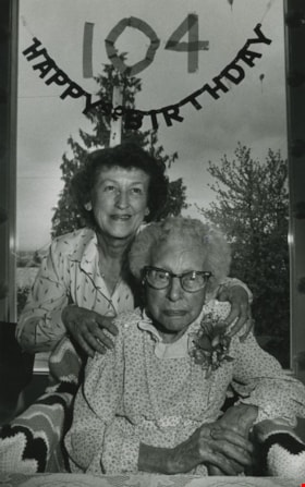
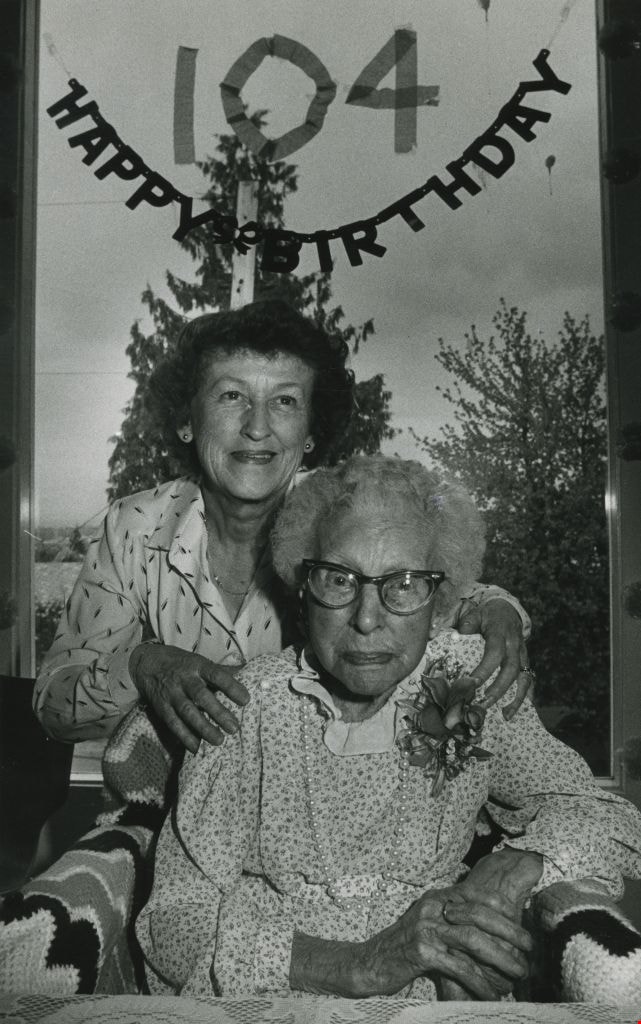
Elizabeth McIntyre's 104th birthday
https://search.heritageburnaby.ca/link/archivedescription45981
- Repository
- City of Burnaby Archives
- Date
- May 1983
- Collection/Fonds
- Columbian Newspaper collection
- Description Level
- Item
- Physical Description
- 1 photograph : b&w ; 22 x 14 cm
- Scope and Content
- Photograph of Elizabeth McIntyre, being hugged by her niece Jean Braaten, on her 104th birthday. The party was held at Carlton Hospital, where she was residing.
- Repository
- City of Burnaby Archives
- Date
- May 1983
- Collection/Fonds
- Columbian Newspaper collection
- Physical Description
- 1 photograph : b&w ; 22 x 14 cm
- Description Level
- Item
- Record No.
- 480-876
- Access Restriction
- No restrictions
- Reproduction Restriction
- Reproduce for fair dealing purposes only
- Accession Number
- 2003-02
- Scope and Content
- Photograph of Elizabeth McIntyre, being hugged by her niece Jean Braaten, on her 104th birthday. The party was held at Carlton Hospital, where she was residing.
- Subjects
- Celebrations
- Media Type
- Photograph
- Photographer
- Battistoni, Peter
- Notes
- Title based on contents of photograph
- Geographic Access
- Canada Way
- Street Address
- 4125 Canada Way
- Historic Neighbourhood
- Broadview (Historic Neighbourhood)
- Planning Study Area
- Cascade-Schou Area
Images
![Hill family, [189-] (date of original), copied 1986 thumbnail](/media/hpo/_Data/_Archives_Images/_Unrestricted/204/204-794.jpg?width=280)
Hill family
https://search.heritageburnaby.ca/link/archivedescription35934
- Repository
- City of Burnaby Archives
- Date
- [189-] (date of original), copied 1986
- Collection/Fonds
- Burnaby Historical Society fonds
- Description Level
- Item
- Physical Description
- 1 photograph : b&w ; 12.7 x 17.8 cm print
- Scope and Content
- Photograph of Bernard Hill (centre) and Gerry Hill (right) on the Bernard Hill family veranda. The three women are unidentified.
- Repository
- City of Burnaby Archives
- Date
- [189-] (date of original), copied 1986
- Collection/Fonds
- Burnaby Historical Society fonds
- Subseries
- Pioneer Tales subseries
- Physical Description
- 1 photograph : b&w ; 12.7 x 17.8 cm print
- Description Level
- Item
- Record No.
- 204-794
- Access Restriction
- No restrictions
- Reproduction Restriction
- No restrictions
- Accession Number
- BHS1988-03
- Scope and Content
- Photograph of Bernard Hill (centre) and Gerry Hill (right) on the Bernard Hill family veranda. The three women are unidentified.
- Media Type
- Photograph
- Notes
- Title based on contents of photograph
- Geographic Access
- Canada Way
- Street Address
- 4990 Canada Way
- Historic Neighbourhood
- Burnaby Lake (Historic Neighbourhood)
- Planning Study Area
- Douglas-Gilpin Area
Images
![Hill family, [189-] (date of original), copied 1986 thumbnail](/media/hpo/_Data/_Archives_Images/_Unrestricted/204/204-794.jpg)
![Hill family, [1915] thumbnail](/media/hpo/_Data/_Archives_Images/_Unrestricted/477/477-194.jpg?width=280)
Hill family
https://search.heritageburnaby.ca/link/archivedescription38875
- Repository
- City of Burnaby Archives
- Date
- [1915]
- Collection/Fonds
- Peers Family and Hill Family fonds
- Description Level
- Item
- Physical Description
- 1 photograph : b&w ; 6.5 x 10.5 cm on page 14 x 17.5 cm (pasted in album)
- Scope and Content
- Photograph of members of the Hill family of Burnaby Lake. Left to right (standing): Kitty Hill (daughter of L. Claude Hill and niece of Bernard R.), A. Claude Hill (son of Bernard R. Hill), and Mr. A.D. Sever (seated on railing). Seated on back step are Mr. Bernard R. Hill and his daughter, Winnie…
- Repository
- City of Burnaby Archives
- Date
- [1915]
- Collection/Fonds
- Peers Family and Hill Family fonds
- Physical Description
- 1 photograph : b&w ; 6.5 x 10.5 cm on page 14 x 17.5 cm (pasted in album)
- Description Level
- Item
- Record No.
- 477-194
- Access Restriction
- No restrictions
- Reproduction Restriction
- No known restrictions
- Accession Number
- 2007-12
- Scope and Content
- Photograph of members of the Hill family of Burnaby Lake. Left to right (standing): Kitty Hill (daughter of L. Claude Hill and niece of Bernard R.), A. Claude Hill (son of Bernard R. Hill), and Mr. A.D. Sever (seated on railing). Seated on back step are Mr. Bernard R. Hill and his daughter, Winnie Hill. Seated on the front step are (left) Marion Hill (wife of A. Claude) and Marian Hill (wife of Bernard R.). This photograph was most likely taken at the home of Bernard Hill.
- Names
- Hill, A. Claude
- Hill, Bernard R.
- Hill, Marion
- Hill, Marian Berkeley
- Peers, Katherine Maude Hill "Kitty"
- Sever, A.D.
- Rowe, Winnie Hill
- Media Type
- Photograph
- Notes
- Title based on contents of photograph
- Geographic Access
- Canada Way
- Street Address
- 4990 Canada Way
- Historic Neighbourhood
- Burnaby Lake (Historic Neighbourhood)
- Planning Study Area
- Douglas-Gilpin Area
Images
![Hill family, [1915] thumbnail](/media/hpo/_Data/_Archives_Images/_Unrestricted/477/477-194.jpg)
![Hill family, [1915] thumbnail](/media/hpo/_Data/_Archives_Images/_Unrestricted/477/477-195.jpg?width=280)
Hill family
https://search.heritageburnaby.ca/link/archivedescription38876
- Repository
- City of Burnaby Archives
- Date
- [1915]
- Collection/Fonds
- Peers Family and Hill Family fonds
- Description Level
- Item
- Physical Description
- 1 photograph : sepia ; 6 x 10.5 cm on page 14 x 17.5 cm (pasted in album)
- Scope and Content
- Photograph of members of the Hill family of Burnaby Lake. Left to right (standing): A. Claude Hill (son of Bernard R. Hill), Marion Hill (wife of A. Claude), Kitty Hill (daughter of L. Claude Hill and niece to Bernard R.) and Mr. A.D. Sever (seated on railing). Seated are Mr. Bernard R. Hill and …
- Repository
- City of Burnaby Archives
- Date
- [1915]
- Collection/Fonds
- Peers Family and Hill Family fonds
- Physical Description
- 1 photograph : sepia ; 6 x 10.5 cm on page 14 x 17.5 cm (pasted in album)
- Description Level
- Item
- Record No.
- 477-195
- Access Restriction
- No restrictions
- Reproduction Restriction
- No known restrictions
- Accession Number
- 2007-12
- Scope and Content
- Photograph of members of the Hill family of Burnaby Lake. Left to right (standing): A. Claude Hill (son of Bernard R. Hill), Marion Hill (wife of A. Claude), Kitty Hill (daughter of L. Claude Hill and niece to Bernard R.) and Mr. A.D. Sever (seated on railing). Seated are Mr. Bernard R. Hill and his daughter, Winnie Hill directly in front of him with his wife Marian Hill beside her. This photograph was most likely taken at the home of Bernard Hill.
- Names
- Hill, A. Claude
- Hill, Bernard R.
- Hill, Marion
- Hill, Marian Berkeley
- Rowe, Winnie Hill
- Peers, Katherine Maude Hill "Kitty"
- Sever, A.D.
- Media Type
- Photograph
- Notes
- Title based on contents of photograph
- Geographic Access
- Canada Way
- Street Address
- 4990 Canada Way
- Historic Neighbourhood
- Burnaby Lake (Historic Neighbourhood)
- Planning Study Area
- Douglas-Gilpin Area
Images
![Hill family, [1915] thumbnail](/media/hpo/_Data/_Archives_Images/_Unrestricted/477/477-195.jpg)
Interview with Harry Toy, Beverley Babey and Christina Toy
https://search.heritageburnaby.ca/link/museumdescription20285
- Repository
- Burnaby Village Museum
- Date
- [1905-2023] (interview content), interviewed 25 Sep. 2023
- Collection/Fonds
- Burnaby Village Museum fonds
- Description Level
- Item
- Physical Description
- 1 sound recordings (wav) (121min., 14 sec.) + 1 sound recording (mp3) (121 min., 13 sec.)
- Scope and Content
- Item consists of a recording of an oral history interview with Harry Toy, Beverley Babey and Christina Toy conducted by Burnaby Village Museum researcher Denise Fong on September 25, 2023. The interview is divided into four sections: early life of Harry Toy, the Canada Way Food Market, the Fraser M…
- Repository
- Burnaby Village Museum
- Collection/Fonds
- Burnaby Village Museum fonds
- Series
- Museum Oral Histories series
- Subseries
- Many Voices Project Interviews subseries
- Description Level
- Item
- Physical Description
- 1 sound recordings (wav) (121min., 14 sec.) + 1 sound recording (mp3) (121 min., 13 sec.)
- Material Details
- Interviewer: Denise Fong Interviewees: Harry Toy, Beverley Babey and Christina Toy Location of Interview: Residence of Harry Toy Interview Date: September 25, 2023 Total Number of tracks: 1 Total Length of all Tracks: 02:01:13 Digital master recording (wav) was converted to mp3 for access on Heritage Burnaby
- Scope and Content
- Item consists of a recording of an oral history interview with Harry Toy, Beverley Babey and Christina Toy conducted by Burnaby Village Museum researcher Denise Fong on September 25, 2023. The interview is divided into four sections: early life of Harry Toy, the Canada Way Food Market, the Fraser Merchants’ Association and Harry's daughters, Beverley Babey and Christina Toy's memories of growing up in Burnaby. 00:00:00 – 00:23:53 Harry Toy shares biographical information about himself and his ancestors. Harry provides information about his migration to Canada and his life in Manitoba, attending school, working at the family restaurant and teaching high school. 00:23:53 – 00:41:16 Harry talks about moving his family to Burnaby and his experiences owning and operating the Canada Way Food Market. 00:41:17 – 00:54:19 Harry talks about his involvement with the Fraser Merchants Association (FMA) and provides some history about the organization. 00:54:20 – 1:22:44 Harry talks about running the Canada Way Food Market and the alterations that he made to the store over the years. Harry and his daughters comment as they look through photographs of Harry and his store and the Fraser Merchants Association. 1:22:45 – 2:01:14 Beverley and Christina talk about their early childhood in Manitoba and growing up in Burnaby. They recall what it was like growing up and working in the family owned store.
- History
- Interviewee biography: Harry Wee Koon Toy was born in February 9, 1936 in Taikong, Toisan county, Guangdong, China. Harry's father William Toy came to Canada in the early 1920s when he was ten years old. Harry arrived in Vancouver, Canada on September 9, 1950. After staying in Vancouver for one night, he joined his father in Neepawa, Manitoba where the family operated a cafe business (Royal Cafe). Harry grew up in Neepawa and graduated from the University of Manitoba and teacher's college. He became a high school teacher and worked at schools in Minnedosa and Gladstone, Manitoba teaching various subjects including, science, business, geography, history and physical education. Harry and his wife, had three daughters, Melinda, Beverley and Christina who were all born in Neepawa. When the family decided to move to the west coast, Harry was introduced to the grocery store business through an uncle who was a store operator. Around 1970, Harry purchased a grocery store at 4694 Canada Way in Burnaby which he named "Canada Way Food Market" and Harry and his daughters made their home at the back of the store. Harry owned and operated the store for approximately 40 years between 1970 and 2010. Around 1986, Harry purchased the butcher shop next door (4692 Canada Way) which was no longer in operation, expanding his store and adding a second storey to use a residence. Harry's children helped him operate the store throughout their childhood. In the early 1970s, corner stores were threatened by the spread of small chain-operated convenience stories from Eastern Canada to Vancouver. Formed in April 1972, the Fraser Merchants’ Association was established to protect the rights of corner store operators. With no paid legal help, the association was incorporated in Victoria, BC for the cost of 56 cents. The benefits of being a member of the association included warehouse and group purchasing, common advertising and other advantages of being part of an association. Founded by Gary Lee Ling and five others, Fraser Merchants’ Association’s first member was Graham Grocery. By 1978, the association represented over 200 corner stores in the Lower Mainland (Delta, Surrey, White Rock, Langley, Coquitlam, and New Westminster) and Fraser Valley. The association remained active into the 1980s and 1990s. Harry has served as President of the Fraser Merchants' Association from 1992 to present. Interviewer biography: Denise Fong is a historical researcher at Burnaby Village Museum. She has degrees in Anthropology (BA) and Archaeology (MA), and is completing her doctoral degree at UBC in Interdisciplinary Studies. Her primary research interests are in Chinese Canadian history and critical heritage studies. She is the co-curator of BVM’s “Across the Pacific” exhibition, and the Museum of Vancouver’s “A Seat at the Table – Chinese Immigration and British Columbia”.
- Creator
- Burnaby Village Museum
- Subjects
- Education
- Migration
- Occupations - Teachers
- Occupations - Grocers
- Organizations
- Organizations - Business Associations
- Persons - Chinese Canadians
- Social Issues
- Social Issues - Racism
- Buildings - Commercial - Grocery Stores
- Names
- Toy, Christina
- Toy, Harry Wee Koon "Harry"
- Babey, Beverley
- Canada Way Food Market
- Fraser Merchants' Association
- Responsibility
- Fong, Denise
- Geographic Access
- Canada Way
- Street Address
- 4694 Canada Way
- Accession Code
- BV023.16.19
- Access Restriction
- No restrictions
- Reproduction Restriction
- No known restrictions
- Date
- [1905-2023] (interview content), interviewed 25 Sep. 2023
- Media Type
- Sound Recording
- Related Material
- See also: BV023.25 - Harry Toy fonds
- Notes
- Title based on contents of item
- Transcription available
Documents
Audio Tracks
Interview with Harry Toy, Beverley Babey and Christina Toy, [1905-2023] (interview content), interviewed 25 Sep. 2023
Interview with Harry Toy, Beverley Babey and Christina Toy, [1905-2023] (interview content), interviewed 25 Sep. 2023
https://search.heritageburnaby.ca/media/hpo/_Data/_BVM_Sound_Recordings/Oral_Histories/2023_0016_0019_002.mp3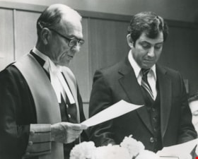
Justice G. L. Murray swearing in Mayor Dave Mercier
https://search.heritageburnaby.ca/link/archivedescription46289
- Repository
- City of Burnaby Archives
- Date
- March 11, 1980
- Collection/Fonds
- Columbian Newspaper collection
- Description Level
- Item
- Physical Description
- 1 photograph : b&w ; 19 x 24 cm
- Scope and Content
- Photograph of Justice G. L. Murray administrating the oath of office to Mayor Dave Mercier. Dave Mercier was a council member from 1968 to 1971, and from 1977 to 1981, serving as Mayor from 1979 to 1981.
- Repository
- City of Burnaby Archives
- Date
- March 11, 1980
- Collection/Fonds
- Columbian Newspaper collection
- Physical Description
- 1 photograph : b&w ; 19 x 24 cm
- Description Level
- Item
- Record No.
- 480-1177
- Access Restriction
- No restrictions
- Reproduction Restriction
- No restrictions
- Accession Number
- 2003-02
- Scope and Content
- Photograph of Justice G. L. Murray administrating the oath of office to Mayor Dave Mercier. Dave Mercier was a council member from 1968 to 1971, and from 1977 to 1981, serving as Mayor from 1979 to 1981.
- Media Type
- Photograph
- Photographer
- King, Basil
- Notes
- Title based on contents of photograph
- Geographic Access
- Canada Way
- Street Address
- 4949 Canada Way
- Historic Neighbourhood
- Burnaby Lake (Historic Neighbourhood)
- Planning Study Area
- Douglas-Gilpin Area
Images

![Living room at Bernard Hill's house, [189-] (date of original), copied 1977 thumbnail](/media/hpo/_Data/_BVM_Images/1977/1977_0123_0040_001.jpg?width=280)
Living room at Bernard Hill's house
https://search.heritageburnaby.ca/link/museumdescription634
- Repository
- Burnaby Village Museum
- Date
- [189-] (date of original), copied 1977
- Collection/Fonds
- Burnaby Village Museum Photograph collection
- Description Level
- Item
- Physical Description
- 1 photograph : b&w ; 20.2 x 25.2 cm print
- Scope and Content
- Photograph of the living room at Bernard Hill's house which was built in 1892 on Douglas Road, later renamed in part Canada Way. Prominent in the photograph is the wallpaper with floral motif and a piano with the top cluttered with vases, plates, framed photographs, etc. The piano stool has an an…
- Repository
- Burnaby Village Museum
- Collection/Fonds
- Burnaby Village Museum Photograph collection
- Description Level
- Item
- Physical Description
- 1 photograph : b&w ; 20.2 x 25.2 cm print
- Scope and Content
- Photograph of the living room at Bernard Hill's house which was built in 1892 on Douglas Road, later renamed in part Canada Way. Prominent in the photograph is the wallpaper with floral motif and a piano with the top cluttered with vases, plates, framed photographs, etc. The piano stool has an antimacassar, and there is a chair to the left side. Also visible on the left side is a fireplace. This photograph is cropped and reproduced in Michael Sone's book, "Pioneer Tales of Burnaby," pg. 27.
- Subjects
- Furniture
- Musical Instruments - Pianos
- Geographic Access
- Canada Way
- Street Address
- 4990 Canada Way
- Accession Code
- HV977.123.40
- Access Restriction
- No restrictions
- Reproduction Restriction
- No known restrictions
- Date
- [189-] (date of original), copied 1977
- Media Type
- Photograph
- Historic Neighbourhood
- Burnaby Lake (Historic Neighbourhood)
- Planning Study Area
- Douglas-Gilpin Area
- Scan Resolution
- 600
- Scan Date
- 2023-07-25
- Notes
- Title based on contents of photograph
Images
![Living room at Bernard Hill's house, [189-] (date of original), copied 1977 thumbnail](/media/hpo/_Data/_BVM_Images/1977/1977_0123_0040_001.jpg)
![Mayor Lewarne and Council Members, [between 1981 and 1983] thumbnail](/media/hpo/_Data/_Archives_Images/_Unrestricted/316/351-001.jpg?width=280)
Mayor Lewarne and Council Members
https://search.heritageburnaby.ca/link/archivedescription37331
- Repository
- City of Burnaby Archives
- Date
- [between 1981 and 1983]
- Collection/Fonds
- Burnaby Historical Society fonds
- Description Level
- Item
- Physical Description
- 1 photograph : col. ; 20 x 25 cm
- Scope and Content
- Photograph of Mayor William Lewarne and Council members, 1981-1983. Back row (l to r): Alan Emmott, Egon Nikolai, Vic Stusiak, Donald Brown, Doug Drummond. Front row (l to r) George McLean, Tom Constable, William Lewarne, and Doreen Lawson. The photograph was taken in Council Chambers at Burnaby…
- Repository
- City of Burnaby Archives
- Date
- [between 1981 and 1983]
- Collection/Fonds
- Burnaby Historical Society fonds
- Subseries
- Municipal record subseries
- Physical Description
- 1 photograph : col. ; 20 x 25 cm
- Description Level
- Item
- Record No.
- 351-001
- Access Restriction
- No restrictions
- Reproduction Restriction
- Reproduce for fair dealing purposes only
- Accession Number
- BHS1997-11
- Scope and Content
- Photograph of Mayor William Lewarne and Council members, 1981-1983. Back row (l to r): Alan Emmott, Egon Nikolai, Vic Stusiak, Donald Brown, Doug Drummond. Front row (l to r) George McLean, Tom Constable, William Lewarne, and Doreen Lawson. The photograph was taken in Council Chambers at Burnaby Municipal Hall.
- Subjects
- Officials - Alderman and Councillors
- Buildings - Civic - City Halls
- Officials - Mayors and Reeves
- Names
- Emmott, Alan H.
- Nikolai, Egon
- Stusiak, Victor V. "Vic"
- Brown, Donald N. "Don"
- Drummond, Douglas P. "Doug"
- McLean, George H.F.
- Constable, Thomas W. "Tom"
- Lewarne, William A. "Bill"
- Lawson, Doreen A.
- Burnaby City Hall
- Media Type
- Photograph
- Notes
- Title based on contents of photograph
- Geographic Access
- Canada Way
- Street Address
- 4949 Canada Way
- Historic Neighbourhood
- Burnaby Lake (Historic Neighbourhood)
- Planning Study Area
- Douglas-Gilpin Area
Images
![Mayor Lewarne and Council Members, [between 1981 and 1983] thumbnail](/media/hpo/_Data/_Archives_Images/_Unrestricted/316/351-001.jpg)
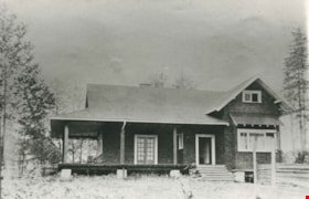
Pontifex family home
https://search.heritageburnaby.ca/link/archivedescription35343
- Repository
- City of Burnaby Archives
- Date
- 1913 (date of original), copied 1986
- Collection/Fonds
- Burnaby Historical Society fonds
- Description Level
- Item
- Physical Description
- 1 photograph : b&w ; 12.7 x 17.8 cm print
- Scope and Content
- Photograph of the Robert Pontifex family home on Douglas Road. Robert and his wife, Beatrix Pontifex, had seven children: Vivien, Helen, Bob, Audrey, Barbara, Basil, and Hugh. Robert built this house with the help of Bernard Hill. The site of this house is now bounded by Century Park Way, Gilpin …
- Repository
- City of Burnaby Archives
- Date
- 1913 (date of original), copied 1986
- Collection/Fonds
- Burnaby Historical Society fonds
- Subseries
- Pioneer Tales subseries
- Physical Description
- 1 photograph : b&w ; 12.7 x 17.8 cm print
- Description Level
- Item
- Record No.
- 204-200
- Access Restriction
- No restrictions
- Reproduction Restriction
- No known restrictions
- Accession Number
- BHS1988-03
- Scope and Content
- Photograph of the Robert Pontifex family home on Douglas Road. Robert and his wife, Beatrix Pontifex, had seven children: Vivien, Helen, Bob, Audrey, Barbara, Basil, and Hugh. Robert built this house with the help of Bernard Hill. The site of this house is now bounded by Century Park Way, Gilpin Street and Canada Way, and became the site of City Hall.
- Subjects
- Buildings - Residential - Houses
- Media Type
- Photograph
- Notes
- Title based on contents of photograph
- Geographic Access
- Canada Way
- Street Address
- 4949 Canada Way
- Historic Neighbourhood
- Burnaby Lake (Historic Neighbourhood)
- Planning Study Area
- Douglas-Gilpin Area
Images