Narrow Results By
Format
- Architectural Drawing 204
- Book 111
- Bylaws - Adopted 1508
- Bylaws - Repealed 99
- Cartographic Material 5
- Council - Committee Report 1442
- Council - Manager's Report 3428
- Council - Mayor/Councillor/Staff Report 166
- Council - Public Hearing Minutes 116
- Council - Regular Council Minutes 320
- Graphic Material 18
- Landmark Description
Decade
- 2020s 44
- 2010s 172
- 2000s
- 1990s 358
- 1980s 366
- 1970s 375
- 1960s 378
- 1950s 381
- 1940s 288
- 1930s 354
- 1920s 262
- 1910s 213
- 1900s 105
- 1890s 54
- 1880s 14
- 1870s 12
- 1860s 16
- 1850s 9
- 1840s 6
- 1830s 5
- 1820s 5
- 1810s 6
- 1800s
- 1790s 5
- 1780s 5
- 1770s 5
- 1760s 5
- 1750s 5
- 1740s 5
- 1730s 5
- 1720s 5
- 1710s 5
- 1700s 5
- 1690s 5
- 1680s 5
- 1670s 4
- 1660s 4
- 1650s 4
- 1640s 4
- 1630s 4
- 1620s 4
- 1610s 4
- 1600s 4
- 1590s 1
- 1580s 1
- 1570s
- 1560s 1
- 1550s 1
- 1540s 1
- 1530s 1
- 1520s 1
- 1510s 1
- 1500s 1
- 1490s 1
- 1480s 1

Ardingley-Sprott Neighbourhood
https://search.heritageburnaby.ca/link/landmark797
- Repository
- Burnaby Heritage Planning
- Associated Dates
- 1955-2008
- Heritage Value
- The Ardingley-Sprott Neighbourhood is primarily non-residential and developed in the 1970s west of the Burnaby Lake park area. It grew to include a large recreational component in the form of the Burnaby Lake Sports Complex and playing fields.
- Historic Neighbourhood
- Burnaby Lake (Historic Neighbourhood)
- Planning Study Area
- Ardingley-Sprott Area
Images


Big Bend Neighbourhood
https://search.heritageburnaby.ca/link/landmark840
- Repository
- Burnaby Heritage Planning
- Associated Dates
- 1955-2008
- Heritage Value
- The Big Bend Neighbourhood in Burnaby maintained its status as an important agricultural area in the City in the years following 1955 and it also solidified its role as a prime industrial and commercial district. In 1972, the Big Bend Development Plan was adopted by Council and soon thereafter, approximately 620 acres of land were incorporated into the Agricultural Land Reserve. These lands have been set aside for agricultural and limited recreation purposes. By the 2000s, 160 acres of land were considered highly productive agricultural areas, and over 400 acres of land had been secured as parkland, including the Fraser Foreshore Park. The area also developed large commercial and industrial districts including those at Marine Way/Boundary, the Glenlyon Estates, Riverfront Business Park, Burnaby Business Park, and Glenwood Industrial Estates.
- Historic Neighbourhood
- Fraser Arm (Historic Neighbourhood)
- Planning Study Area
- Big Bend Area
Images


Brentwood Neighbourhood
https://search.heritageburnaby.ca/link/landmark780
- Repository
- Burnaby Heritage Planning
- Associated Dates
- 1955-2008
- Heritage Value
- Between 1955 and 2001, the Brentwood Neighbourhood developed into one of Burnaby's four official Town Centres. The Brentwood Town Centre serves the north-west sector of the Municipality, providing facilities such as commercial developments - of which the Brentwood Mall is the most significant. Under Burnaby's Residential Development Framework adopted by Council in 1981, the Town Centre also incorporated a full range of multi-housing types and forms in close relationship with their commercial facilities. In 1996, the City adopted the Brentwood Town Centre Development Plant to solidify the area as a focus of higher-density and higher-intensity residential and commercial opportunities, public transit and supporting leisure facilities.
- Planning Study Area
- Brentwood Area
Images


Burnaby Heights Neighbourhood
https://search.heritageburnaby.ca/link/landmark776
- Repository
- Burnaby Heritage Planning
- Associated Dates
- 1955-2008
- Heritage Value
- Up until the 1970s, this neighbourhood was known as Vancouver Heights. When a new park was created during that decade and named "Burnaby Heights Park," the name was gradually adopted by newcomers to the area. Today, you will hear residents refer to their neighbourhood as Burnaby Heights, Vancouver Heights, or just "The Heights." Throughout the 1960s and 1970s, the commercial district in this neighbourhood continued to grow and a Retail Merchants Association was formed which later became known as the Heights Merchants Association. The neighbourhood still retains a residential neighbourhood characteristic with an increasing number of apartment buildings and multi-family units being built over the past 20 years.
- Historic Neighbourhood
- Vancouver Heights (Historic Neighbourhood)
- Planning Study Area
- Burnaby Heights Area
Images


Burnaby Lake Neighbourhood
https://search.heritageburnaby.ca/link/landmark821
- Repository
- Burnaby Heritage Planning
- Associated Dates
- 1955-2008
- Heritage Value
- In 1966 Burnaby Lake was identified as a key potential regional park in the GVRD ’s Regional Park Plan for the Lower Mainland. The lake was to be developed for nature study, strolling, trail riding, canoeing, sightseeing and picnicking. It was formally recognized as a regional nature park in 1979, at which time the GVRD assumed management of the park through a lease agreement with the City of Burnaby. In 1993 Burnaby Lake was selected by the City of Burnaby to be included in Greater Vancouver ’s Green Zone, and was identified as a key component of the GVRD ’s Park and Outdoor Recreation System (PORS) for the Burrard/Peninsula/Richmond sector, which includes Burnaby, Vancouver, New Westminster, and Richmond.
- Historic Neighbourhood
- Burnaby Lake (Historic Neighbourhood)
- Planning Study Area
- Burnaby Lake Area
Images


Burnaby Mountain Neighbourhood
https://search.heritageburnaby.ca/link/landmark792
- Repository
- Burnaby Heritage Planning
- Associated Dates
- 1955-2008
- Heritage Value
- Burnaby Mountain had been dedicated as park in 1942, however the original park boundaries were reconsidered in 1952 with the development of the Trans Mountain Pipeline. Although the boundaries were adjusted to accommodate this project, significant conservation and park lands were left untouched. When, in 1962, the government of British Columbia determined the need for additional post-secondary facilities, Burnaby Mountain was chosen as the site for the new Simon Fraser University which opened in 1965. As early as 1964, the idea of establishing a townsite around the university had been discussed by Burnaby, but it was not until the mid-1990s that the idea came to fruition and by the early 2000s, a new housing development know as the UniverCity took shape on the mountain adjacent to the university.
- Historic Neighbourhood
- Barnet (Historic Neighbourhood)
- Planning Study Area
- Burnaby Mountain Area
Images


Burnaby Mountain Secondary School
https://search.heritageburnaby.ca/link/landmark831
- Repository
- Burnaby Heritage Planning
- Geographic Access
- Eastlake Drive
- Associated Dates
- 2000
- Heritage Value
- Burnaby Mountain Secondary School is one of the more recent schools in Burnaby, having opened in 2000 and it serves neighbourhoods in northeast Burnaby and northwest Coquitlam.
- Historic Neighbourhood
- Burquitlam (Historic Neighbourhood)
- Planning Study Area
- Lyndhurst Area
- Street Address
- 8800 Eastlake Drive
- Street View URL
- Google Maps Street View
Images


Byrne Creek Secondary School
https://search.heritageburnaby.ca/link/landmark849
- Repository
- Burnaby Heritage Planning
- Geographic Access
- 18th Street
- Associated Dates
- 2005
- Heritage Value
- Byrne Creek School opened in 2005 and accommodates students from grades 8 through 12. When built, the school was created to house as many as 1200 students, but by 2009, plans have been prepared to increase that capacity to 1500.
- Historic Neighbourhood
- Edmonds (Historic Neighbourhood)
- Planning Study Area
- Stride Avenue Area
- Street Address
- 7777 18th Street
- Street View URL
- Google Maps Street View
Images


Cameron Neighbourhood
https://search.heritageburnaby.ca/link/landmark824
- Repository
- Burnaby Heritage Planning
- Associated Dates
- 1955-2008
- Heritage Value
- The Cameron Neighbourhood falls within the Lougheed Town Centre area - one of four Town Centres in Burnaby. The Cameron Neighbourhood - while containing significant high-density residential components - is also home to the Town Centre's office and commercial core. The Lougheed Mall is situated in this neighbourhood, which is served by the Millennium Line SkyTrain.
- Historic Neighbourhood
- Burquitlam (Historic Neighbourhood)
- Planning Study Area
- Cameron Area
Images


Capitol Hill Neighbourhood
https://search.heritageburnaby.ca/link/landmark781
- Repository
- Burnaby Heritage Planning
- Associated Dates
- 1955-2008
- Heritage Value
- The Capitol Hill Neighbourhood remained a primarily residential neighbourhood after the population boom of the 1950s and 1960s. The commercial focus remained the Hastings Street corridor, while the City of Burnaby moved to protect a conservation area on the north side of Capitol Hill and dedicated parkland throughout the 1970s and 1980s.
- Historic Neighbourhood
- Capitol Hill (Historic Neighbourhood)
- Planning Study Area
- Capitol Hill Area
Images


Cariboo-Armstrong Neighbourhood
https://search.heritageburnaby.ca/link/landmark825
- Repository
- Burnaby Heritage Planning
- Associated Dates
- 1955-2008
- Heritage Value
- The Cariboo-Armstrong Neighbourhood was mainly subdivided in the 1950s during the major building boom in Burnaby throughout the post-war years. Considered a primarily residential area, the neighbourhood has quick and convenient access to major highways and roads as well as being bordered to the north by the George Derby Conservation area.
- Historic Neighbourhood
- East Burnaby (Historic Neighbourhood)
- Planning Study Area
- Cariboo-Armstrong Area
Images


Cascade-Schou Neighbourhood
https://search.heritageburnaby.ca/link/landmark798
- Repository
- Burnaby Heritage Planning
- Associated Dates
- 1955-2008
- Heritage Value
- The Cascade-Schou neighbourhood, sometimes referred to as the Cascade Heights area, includes both the Burnaby General Hospital site, the Discovery Park facilities and is bordered on its eastern boundary by BCIT. Despite these health and science developments, the neighbourhood can still be considered to be a residential community. The housing stock includes single family homes as well as newer multi-family residences that developed throughout the 1980s and 1990s.
- Historic Neighbourhood
- Broadview (Historic Neighbourhood)
- Planning Study Area
- Cascade-Schou Area
Images


City of Burnaby Archives
https://search.heritageburnaby.ca/link/landmark783
- Repository
- Burnaby Heritage Planning
- Geographic Access
- Albert Street
- Associated Dates
- 2001
- Heritage Value
- The City of Burnaby Archives officially opened on Saturday, November 10, 2001. The Archives is Burnaby's first municipal archives, and is located in the McGill Branch Library. The City Archives functions as a branch of the Office of the City Clerk and operates as the official repository of Burnaby's municipal records, containing records dating back to Burnaby's incorporation in 1892. In 2007, the City of Burnaby Archives expanded its collection mandate to include private as well as public records. On February 14, 2007 an agreement was signed with the Burnaby Historical Society and, as a result, the Archives accepted into its custody the collection of community records that had been maintained and managed by the Historical Society since the 1950s. In the Spring of 2007, these records were transferred from the Burnaby Village Museum to their permanent home in the Archives facility.
- Historic Neighbourhood
- Capitol Hill (Historic Neighbourhood)
- Planning Study Area
- Capitol Hill Area
- Street Address
- 4595 Albert Street
- Street View URL
- Google Maps Street View
Images


Clinton-Glenwood Neighbourhood
https://search.heritageburnaby.ca/link/landmark841
- Repository
- Burnaby Heritage Planning
- Associated Dates
- 1955-2008
- Heritage Value
- The primarily single-family subdivision and development in the Clinton-Glenwood Neighbourhood occurred during the building boom of the 1950s. Later development fell under the guidelines established in the Royal Oak Community Plan (adopted in 1999) and resulted in an increase in the number of multi-family units.
- Historic Neighbourhood
- Alta Vista (Historic Neighbourhood)
- Planning Study Area
- Clinton-Glenwood Area
Images


Dawson-Delta Neighbourhood
https://search.heritageburnaby.ca/link/landmark779
- Repository
- Burnaby Heritage Planning
- Associated Dates
- 1955-2008
- Heritage Value
- The Dawson-Delta neighbourhood in Burnaby developed into one of Burnaby's numerous industrial areas after 1955. The Eastbrook Executive Business Park opened in the 1970s and the Willingdon Green Business Centre includes buildings from the 1980s to the 2000s. Convenient access to major roads and highways fostered these developments which remain zoned for industrial uses to this day.
- Planning Study Area
- Dawson-Delta Area
Images


Douglas-Gilpin Neighbourhood
https://search.heritageburnaby.ca/link/landmark799
- Repository
- Burnaby Heritage Planning
- Associated Dates
- 1955-2008
- Heritage Value
- The Douglas-Gilpin Neighbourhood developed into a diverse area incorporating residential, business, educational and park districts in the period after 1955. The BCIT site was built in the early 1960s, shortly after the Burnaby Municipal Hall was located on Canada Way near Deer Lake in 1956. The construction of the Municipal Hall at this location fostered the creation of an administrative and business centre adjacent to the park, while the northern and central areas of the neighbourhood retained their primarily residential character.
- Historic Neighbourhood
- Burnaby Lake (Historic Neighbourhood)
- Planning Study Area
- Douglas-Gilpin Area
Images


Edmonds Street Neighbourhood
https://search.heritageburnaby.ca/link/landmark827
- Repository
- Burnaby Heritage Planning
- Associated Dates
- 1955-2008
- Heritage Value
- The Edmonds Street Neighbourhood is part of the larger Edmonds Town Centre - one of four Town Centres in Burnaby. This neighbourhood is considered to be primarily residential, but a strong local commercial component developed along Edmonds and Kingsway.
- Historic Neighbourhood
- Edmonds (Historic Neighbourhood)
- Planning Study Area
- Edmonds Area
Images


Garden Village Neighbourhood
https://search.heritageburnaby.ca/link/landmark800
- Repository
- Burnaby Heritage Planning
- Associated Dates
- 1955-2008
- Heritage Value
- Bounded by Moscrop Street to the north, Kingsway and Grange to the south, Willingdon to the east and Boundary Road to the west, the Garden Village Neighbourhood is characterised as a primarily residential area that is well-served due to its proximity to commercial, park and business centres. The north-east corner of the neighbourhood is a typical 1950s subdivision of mostly single family homes located on an irregular street pattern, while the remaining areas saw some transition to multi-family housing types throughout the 1970s and up to the current time.
- Historic Neighbourhood
- Central Park (Historic Neighbourhood)
- Planning Study Area
- Garden Village Area
Images


Government Road Neighbourhood
https://search.heritageburnaby.ca/link/landmark822
- Repository
- Burnaby Heritage Planning
- Associated Dates
- 1955-2008
- Heritage Value
- After the building boom of the 1950s, the Government Road Neighbourhood became characterised as a stable, single-family residential area. In addition to the residential component, the neighbourhood also has a significant industrial sector, along the north side of Burnaby Lake, and a commercial zone to the north along the Lougheed Highway.
- Historic Neighbourhood
- Lozells (Historic Neighbourhood)
- Planning Study Area
- Government Road Area
Images


Kingsway-Beresford Neighbourhood
https://search.heritageburnaby.ca/link/landmark805
- Repository
- Burnaby Heritage Planning
- Associated Dates
- 1955-2008
- Heritage Value
- Since the building boom of the 1950s, the Kingsway-Beresford Neighbourhood has maintained a residential character with the exception of the Kingsway corridor, which has become a primary commercial and light industrial sector.
- Historic Neighbourhood
- Edmonds (Historic Neighbourhood)
- Planning Study Area
- Kingsway-Beresford Area
Images


Lake City Neighbourhood
https://search.heritageburnaby.ca/link/landmark793
- Repository
- Burnaby Heritage Planning
- Associated Dates
- 1955-2008
- Heritage Value
- When Simon Fraser University opened in 1965, approximately sixteen industrial properties had been developed in the Lake City Industrial Park. In addition, significant tracts of land in the western portion had been pre-cleared and graded in anticipation of additional development, while most of the eastern half remained forested. Some of the early companies to locate in the area were Nabob Foods, Volkswagen Canada, British Columbia Television Broadcasting, Simpson Sears, and H.Y. Louie Company Limited. Both Imperial Oil and Shell Oil established petroleum storage and distribution facilities in the area. Initially a heavy industrial area, by 1979, single family neighbourhoods south of Lougheed Highway and west of Eagle Creek had been largely developed. By the mid1980's, the Burnaby 200 multi-family development along Forest Grove Drive had also been completed.
- Planning Study Area
- Lake City Area
Images


Lakeview-Mayfield Neighbourhood
https://search.heritageburnaby.ca/link/landmark830
- Repository
- Burnaby Heritage Planning
- Associated Dates
- 1955-2008
- Heritage Value
- Like many other areas of the City, the Lakeview-Mayfield Neighbourhood was subdivided during the 1950s post-war building boom. Pockets of newer homes were built in the 1970s, and the neighbourhood retained its character as a primarily residential area. The neighbourhood is bordered to the east by Robert Burnaby Park.
- Planning Study Area
- Lakeview-Mayfield Area
Images


Lochdale Neighbourhood
https://search.heritageburnaby.ca/link/landmark790
- Repository
- Burnaby Heritage Planning
- Associated Dates
- 1955-2008
- Heritage Value
- Despite the rapid growth witnessed in Burnaby in the post-war years, the Lochdale Neighbourhood was characterised as a close-knit primarily residential community. Although a commercial zone developed along Sperling and Hastings, single-family, duplex and multi-family homes were the primary buildings in the area. Basement suites and student accommodation also flourished in this neighbourhood after the creation of Simon Fraser University on Burnaby Mountain.
- Historic Neighbourhood
- Lochdale (Historic Neighbourhood)
- Planning Study Area
- Lochdale Area
Images


Lyndhurst Neighbourhood
https://search.heritageburnaby.ca/link/landmark823
- Repository
- Burnaby Heritage Planning
- Associated Dates
- 1955-2008
- Heritage Value
- The Lyndhurst Neighbourhood falls within the Lougheed Town Centre area - one of four Town Centres in Burnaby. The Lyndhurst Neighbourhood accounts for a significant portion of the residential component of the Town Centre. To the east of Stoney Creek Park, lies the Sullivan Heights single family subdivision which was built in the 1950s. To the west of the park, is a higher-density residential area consisting of multi-family buildings that were developed after 1974.
- Historic Neighbourhood
- Burquitlam (Historic Neighbourhood)
- Planning Study Area
- Lyndhurst Area
Images


Marlborough Neighbourhood
https://search.heritageburnaby.ca/link/landmark802
- Repository
- Burnaby Heritage Planning
- Associated Dates
- 1955-2008
- Heritage Value
- The Marlborough Neighbourhood is another residential area that was witness to rapid growth and subdivision during the 1950s and 1960s, creating primarily single-family housing stock. In the 1970s and 1980s, as the commercial district around Kingsway grew, so too did higher density housing projects such as townhomes and condominiums.
- Historic Neighbourhood
- Central Park (Historic Neighbourhood)
- Planning Study Area
- Marlborough Area
Images


Maywood Neighbourhood
https://search.heritageburnaby.ca/link/landmark801
- Repository
- Burnaby Heritage Planning
- Associated Dates
- 1955-2008
- Heritage Value
- Burnaby's Maywood Neighbourhood consists of the Metrotown Town Centre - one of four Town Centres in the City. Metrotown is one of the region's most developed and fastest growing centres. It is served by the first SkyTrain line developed in the mid-1980s and anchored by B.C.'s largest shopping and entertainment complex. As an older centre that has progressively added new developments over the years, Metrotown offers a range of housing types and tenures from three-storey walk-up apartments to modern residential towers.
- Historic Neighbourhood
- Central Park (Historic Neighbourhood)
- Planning Study Area
- Maywood Area
Images


Morley-Buckingham Neighbourhood
https://search.heritageburnaby.ca/link/landmark829
- Repository
- Burnaby Heritage Planning
- Associated Dates
- 1955-2008
- Heritage Value
- In the 1980 "Residential Neighbourhood Environment Study," the Morley-Buckingham Neighbourhood is described as "perhaps Burnaby's most prestigious residential area. The lots are larger than most other areas of the Municipality and this, along with the new expensive housing developed over the past 10 years, has created a very desirable residential neighbourhood...The older area of Buckingham lies at the lower edge of the slope and here the homes and streets are more uniform and aged between 20 and 25 years old...to the east of Canada Way lies...a cluster townhouse development."
- Historic Neighbourhood
- Burnaby Lake (Historic Neighbourhood)
- Planning Study Area
- Morley-Buckingham Area
Images


Oakalla Neighbourhood
https://search.heritageburnaby.ca/link/landmark804
- Repository
- Burnaby Heritage Planning
- Associated Dates
- 1955-2008
- Heritage Value
- The phasing out and demolition of the Oakalla Prison farm allowed for the planned development of the Oakalla Neighbourhood in the 1980s. By 1991, the City of Burnaby had adopted the Oakalla Development Plan which called for the transfer of land to the Deer Lake Park reserve as well as the creation of a new residential area consisting of multi-family housing types.
- Historic Neighbourhood
- Central Park (Historic Neighbourhood)
- Planning Study Area
- Oakalla Area
Images


Parkcrest-Aubrey Neighbourhood
https://search.heritageburnaby.ca/link/landmark782
- Repository
- Burnaby Heritage Planning
- Associated Dates
- 1955-2008
- Heritage Value
- After its initial subdivision and development in the early 1950s, the Parkcrest-Audrey Neighbourhood continued to be a primarily residential area. In the 1980 Residential Neighbourhood Environment Study, the area was characterised as a stable residential neighbourhood that was served by the major collector streets Holdom, Broadway, Parker and Kensington.
- Planning Study Area
- Parkcrest-Aubrey Area
Images


Richmond Park Neighbourhood
https://search.heritageburnaby.ca/link/landmark828
- Repository
- Burnaby Heritage Planning
- Associated Dates
- 1955-2008
- Heritage Value
- The Richmond Park Neighbourhood is part of the larger Edmonds Town Centre - one of four official Town Centres in the City. Richmond Park contains a residential subdivision that developed during the 1950s as well as a strong commercial and retail centre along Edmonds and Kingsway.
- Historic Neighbourhood
- Edmonds (Historic Neighbourhood)
- Planning Study Area
- Richmond Park Area
Images


Second Street Neighbourhood
https://search.heritageburnaby.ca/link/landmark826
- Repository
- Burnaby Heritage Planning
- Associated Dates
- 1955-2008
- Heritage Value
- Second Street had its origins in the 1910-1920 era and the Second Street Elementary School was built in 1928. Substantial new housing was built in the late 1940s and 1950s and infilling occurred during the 1960s and 1970s. By the 1980s, the neighbourhood was primarily a single family area with a small number of multi-family buildings.
- Historic Neighbourhood
- East Burnaby (Historic Neighbourhood)
- Planning Study Area
- Second Street Area
Images


Sperling-Broadway Neighbourhood
https://search.heritageburnaby.ca/link/landmark789
- Repository
- Burnaby Heritage Planning
- Associated Dates
- 1955-2008
- Heritage Value
- By the 1970s, the Sperling-Broadway Neighbourhood was characterised as one of the Municipality's fastest growing residential areas. In 1980, it was estimated that slightly less than half of the homes were single-family residences, while the remaining development was taking the form of townhouse and high-rise apartments. The emphasis shifted back to single family housing during the construction of planned subdivisions such as the Camrose subdivision in the 1980s and the area remains primarily residential in nature. The neighbourhood is well-served by park facilities and is also home to the Burnaby Mountain Golf Course.
- Historic Neighbourhood
- Lochdale (Historic Neighbourhood)
- Planning Study Area
- Sperling-Broadway Area
Images


Stride Avenue Neighbourhood
https://search.heritageburnaby.ca/link/landmark845
- Repository
- Burnaby Heritage Planning
- Associated Dates
- 1955-2008
- Heritage Value
- The interurban link between New Westminster and Vancouver stimulated the early settlement of Stride Avenue. Infilling of the area took place in the early 1950s and the pace of development had slowed considerably by 1970. Duplexes became a popular feature in the decade between 1970 and 1980 and in the late 1980s, the neighbourhood was incorporated into the Edmonds Town Centre South plan.
- Historic Neighbourhood
- Edmonds (Historic Neighbourhood)
- Planning Study Area
- Stride Avenue Area
Images


Stride Hill Neighbourhood
https://search.heritageburnaby.ca/link/landmark846
- Repository
- Burnaby Heritage Planning
- Associated Dates
- 1955-2008
- Heritage Value
- The residential areas that are located within the Stride Hill Neighbourhood were primarily developed in the 1950s during Burnaby's post-war building boom. The area lying to the south of Byrne Creek Ravine Park was used as a municipal garbage dump until the 1960s and as a landfill site for yard waste disposal until the early 1990s at which point the area was incorporated into the Edmonds Town Centre Plan and the land was made into park and open space.
- Historic Neighbourhood
- Edmonds (Historic Neighbourhood)
- Planning Study Area
- Stride Hill Area
Images


Suncrest Neighbourhood
https://search.heritageburnaby.ca/link/landmark839
- Repository
- Burnaby Heritage Planning
- Associated Dates
- 1955-2008
- Heritage Value
- The Suncrest Neighbourhood is a small residential area south of Burnaby's Central Park. The Ocean View Burial Park takes up a large area of land in the north-east corner of this neighbourhood and the majority of the housing was built during the 1930-1960 period.
- Historic Neighbourhood
- Alta Vista (Historic Neighbourhood)
- Planning Study Area
- Suncrest Area
Images


Sussex-Nelson Neighbourhood
https://search.heritageburnaby.ca/link/landmark838
- Repository
- Burnaby Heritage Planning
- Associated Dates
- 1955-2008
- Heritage Value
- The Sussex-Nelson Neighbourhood is located just south of Metrotown and in 1980 was characterised as the most populated of all of Burnaby's Planning Study areas. The area immediately south of Metrotown was initially developed as post-war 1950s housing stock, while the sector south of Rumble was developed after the 1960s and 1970s as single-family housing.
- Historic Neighbourhood
- Alta Vista (Historic Neighbourhood)
- Planning Study Area
- Sussex-Nelson Area
Images


Taylor Park Elementary School
https://search.heritageburnaby.ca/link/landmark847
- Repository
- Burnaby Heritage Planning
- Geographic Access
- Mission Avenue
- Associated Dates
- 2004
- Heritage Value
- Taylor Park Elementary School was opened in 2004 with 240 students from kindergarten to grade three (with older students attending Stride Avenue Community School). By 2006, Taylor Park had been designated as its own school and extended its classes from kindergarten through grade six.
- Historic Neighbourhood
- Edmonds (Historic Neighbourhood)
- Planning Study Area
- Stride Hill Area
- Street Address
- 7590 Mission Avenue
- Street View URL
- Google Maps Street View
Images


West Central Valley Neighbourhood
https://search.heritageburnaby.ca/link/landmark778
- Repository
- Burnaby Heritage Planning
- Associated Dates
- 1955-2008
- Heritage Value
- The West Central Valley Neighbourhood is home to the Bridge Business Park and is a primarily industrial neighbourhood. Similar to the adjacent Dawson-Delta Neighbourhood, West Central Valley offers businesses convenient access to major roads and highways.
- Historic Neighbourhood
- Broadview (Historic Neighbourhood)
- Planning Study Area
- West Central Valley Area
Images


Westridge Neighbourhood
https://search.heritageburnaby.ca/link/landmark791
- Repository
- Burnaby Heritage Planning
- Associated Dates
- 1955-2008
- Heritage Value
- The Westridge Neighbourhood is effectively separated into two areas by Inlet Drive. To the west of the highway lies a typical 1950s subdivision of single-family homes, while to the east is a newer (1970s) subdivision featuring larger lots and some low-rise units. In the 1980 Residential Neighbourhood Environment Study, Westridge was characterised as a stable community with little need for direct Municipal involvement in growth and development.
- Historic Neighbourhood
- Lochdale (Historic Neighbourhood)
- Planning Study Area
- Westridge Area
Images


Willingdon Heights Neighbourhood
https://search.heritageburnaby.ca/link/landmark777
- Repository
- Burnaby Heritage Planning
- Associated Dates
- 1955-2008
- Heritage Value
- The convenient location of Willingdon Heights to the Trans Canada Highway, Lougheed Highway and Hastings Street has fostered its development as a primarily residential commuter neighbourhood. Characterised in the post-World War Two period by predominantly single-family developments, the neighbourhood has retained this identity despite some higher density apartment buildings now found there.
- Planning Study Area
- Willingdon Heights Area
Images


Windsor Neighbourhood
https://search.heritageburnaby.ca/link/landmark803
- Repository
- Burnaby Heritage Planning
- Associated Dates
- 1955-2008
- Heritage Value
- The Windsor Neighbourhood comprises a number of different districts with different characteristics. To the north, stretching to the border of the Deer Lake Park, is the primarily residential area that was developed after the building boom of the 1950s and now consists of a mix of single-family and multi-family housing. To the south, from Kingsway to the Skytrain line, an industrial area was maintained along with a significant commercial corridor along Kingsway. In recent years, the growth and development of this area has been guided by the Royal Oak Community Plan adopted by Council in 1999.
- Planning Study Area
- Windsor Area
Images

Book reading given by Pixie McGeachie January 10, 1973 - Track 2
https://search.heritageburnaby.ca/link/oralhistory238
- Repository
- City of Burnaby Archives
- Date Range
- 1803-1884
- Length
- 0:09:29
- Summary
- This portion of the recording pertains to Pixie McGeachie's continued reading of "Archdeacon on Horseback" by Canon Cyril E.H. Williams and herself. This section of the reading describes the earlier the impact of the gold rush on British Columbia and the formation of Lytton, BC.
- Repository
- City of Burnaby Archives
- Summary
- This portion of the recording pertains to Pixie McGeachie's continued reading of "Archdeacon on Horseback" by Canon Cyril E.H. Williams and herself. This section of the reading describes the earlier the impact of the gold rush on British Columbia and the formation of Lytton, BC.
- Date Range
- 1803-1884
- Photo Info
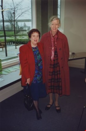
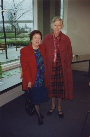
- Pixie McGeachie (left) and Florence Godwin, 1992. Item no. 330-003
- Length
- 0:09:29
- Interview Date
- January 10, 1973
- Scope and Content
- Recording is of a book reading given by Pixie McGeachie on January 10, 1973 to the Burnaby Historical Society from the book "Archdeacon on Horseback" by Canon Cyril E.H. Williams (then archivist in the Vancouver School of Theology, University of British Columbia) and Pixie McGeachie.
- Biographical Notes
- Doreen "Pixie" (Johnson) McGeachie was a resident of Burnaby for over sixty years. Pixie married John Aloysius "Jack" McGeachie and raised their children Kathi (Dunlop) and David McGeachie in the house the couple built themselves in 1947. Pixie served as the editor for the Burnaby Examiner newspaper and wrote a column entitled "Burnaby History" for The News. In 1974 she authored her first book titled "Bygones of Burnaby" which was one of the first to develop anecdotal stories about pioneer life in Burnaby. She authored "Burnaby - A Proud Century" in 1992 and in 2002 she wrote a biography of the city's namesake in the book "Land of Promise: Robert Burnaby's letters from Colonial B.C." She also contributed many hours of volunteering; helping to establish Burnaby's first museum Heritage Village in 1971, serving as President of the Burnaby Historical Society from 1991-1993. She served a six year term on Burnaby's Heritage Commission leading the charge to preserve many historic sites throughout the city, and during her twenty years as the Community Archives volunteer archivist for the historical society, she succeeded in gathering thousands of rare and valuable historic photographs and documents which now forms the core of the photograph collection on the Heritage Burnaby website (as these items were donated by the Society to the City Archives in 2007). The City of Burnaby awarded Pixie McGeachie the Kushiro Cup as Citizen of the year in 2002. In 2006 she received a Heritage BC project award for leading the Friends of Interurban 1223 project, and in 2008 Heritage BC recognised her again by presenting her with the Ruby Nobb Award. John Aloysius "Jack" McGeachie died October 12, 1981 at the age of sixty-seven. Doreen "Pixie" (Johnson) McGeachie died August 14, 2010 at the age of eighty-nine.
- Total Tracks
- 6
- Total Length
- 0:54:31
- Interviewee Name
- McGeachie, Doreen “Pixie”
- Collection/Fonds
- Burnaby Historical Society fonds
- Subseries
- Oral history subseries
- Media Type
- Sound Recording
- Web Notes
- Interview was digitized in 2010 allowing it to be accessible on Heritage Burnaby. The digitization project was initiated by the Community Heritage Commission with support from City of Burnaby Council and the BC History Digitization Program of the Irving K. Barber Learning Centre, University of British Columbia. It was recognized by the Heritage Society of BC with an award in 2012.
Images
Audio Tracks
Track two of recording of a book reading given by Pixie McGeachie
Track two of recording of a book reading given by Pixie McGeachie
https://search.heritageburnaby.ca/media/hpo/_Data/_Archives_Oral_Histories/_Unrestricted/MSS137-017-2/MSS137-017-2_Track_2.mp3Burnaby Historical Society fonds
https://search.heritageburnaby.ca/link/archivedescription97124
- Repository
- City of Burnaby Archives
- Date
- 1892-2018
- Collection/Fonds
- Burnaby Historical Society fonds
- Description Level
- Fonds
- Physical Description
- ca. 130 linear feet of textual records 30 linear feet of graphic and other material
- Scope and Content
- Fonds consists of the Burnaby Historical Society's administrative records and community archives collection.
- Repository
- City of Burnaby Archives
- Date
- 1892-2018
- Collection/Fonds
- Burnaby Historical Society fonds
- Physical Description
- ca. 130 linear feet of textual records 30 linear feet of graphic and other material
- Description Level
- Fonds
- Scope and Content
- Fonds consists of the Burnaby Historical Society's administrative records and community archives collection.
- History
- The Burnaby Historical Society was founded in 1957. The Historical Society developed a community archives by collecting, compiling and preserving various materials with historical value to the City of Burnaby. It gathered miscellaneous documents, photographs and other items while also soliciting and acquiring entire collections or groups of archival records. In 1991, the Historical Society was provided a permanent space to house their growing collection at the Burnaby Village Museum and they continued to collect and expand their holdings. After the creation of the City of Burnaby Archives in 2001, the Burnaby Historical Society and the City of Burnaby began discussing the possibility of uniting the two collections. In February 2007, an agreement was signed between the two institutions which resulted in the merger of the Society's Community Archives with the City Archives. All records and photographs that had been collected by the Historical Society were transferred into the custody of the City and were moved from the Burnaby Village Museum to the City Archives in the McGill Branch of the Burnaby Public Library. The Burnaby Historical Society disbanded in 2018.
- Media Type
- Textual Record
- Photograph
- Sound Recording
- Creator
- Burnaby Historical Society
- Notes
- Title based on contents of fonds
Burnaby Village Museum fonds
https://search.heritageburnaby.ca/link/museumdescription13037
- Repository
- Burnaby Village Museum
- Date
- 1990-2019
- Collection/Fonds
- Burnaby Village Museum fonds
- Description Level
- Fonds
- Physical Description
- Over 3000 photographs + approx. 100 architectural drawings + technical drawings + 25 videocassettes + 43 video recordings (mp4) + 2 video recordings (m4v) + 56 sound recordings (mp3) + 5 audio cassettes + approx. 2 m. of textual records
- Scope and Content
- Fonds consists of a selection of curatorial records created and collected by the Burnaby Village Museum in the course of their work. Records pertain to the village site, exhibits, programs, curatorial projects, outreach and special events. Fonds is arranged in the following series: 1) Museum photo…
- Repository
- Burnaby Village Museum
- Collection/Fonds
- Burnaby Village Museum fonds
- Description Level
- Fonds
- Physical Description
- Over 3000 photographs + approx. 100 architectural drawings + technical drawings + 25 videocassettes + 43 video recordings (mp4) + 2 video recordings (m4v) + 56 sound recordings (mp3) + 5 audio cassettes + approx. 2 m. of textual records
- Scope and Content
- Fonds consists of a selection of curatorial records created and collected by the Burnaby Village Museum in the course of their work. Records pertain to the village site, exhibits, programs, curatorial projects, outreach and special events. Fonds is arranged in the following series: 1) Museum photographs series 2) Museum film collection series 3) Museum architectural records series 4) Museum Marketing photographs series 5) Museum exhibits series 6) Museum reports series 7) Curatorial Collections adminstrative records series 8) Museum Oral Histories series 9) Jesse Love farmhouse series 10) Bell's Dry Goods series 11) Burnaby Neighbourhood Speaker Series series 12) C.W. Parker no. 119 carousel series 13) Royal Bank exhibit series 14) UBC Partnership series 15) Burnaby Community Heritage Commission 125 Video Collection series
- History
- Burnaby Village Museum is an open air museum that represents a typical tram-stop community. Museum interpreters welcome visitors, provide demonstrations and on site programming. The museum’s collection consists of thousands of artifacts, community records as well as several original Burnaby heritage buildings, a 1912 carousel, 1912 B.C. Electric Railway interurban tram, a Chinese Market Garden and Indigenous Learning House and Matriarch's Garden. In 1990, the Corporation of the District of Burnaby assumed the operation and management of Burnaby Village Museum from the Burnaby Village Museum Association. Burnaby Village Museum (formerly named Heritage Village) was originally created by the Burnaby Centennial '71 Committee in 1971 as a commemorative project for British Columbia's Centennial. A concept for an open-air museum was developed near Deer Lake on Districts Lots 79/ 85. The official sod turning for Heritage Village took place on the site on April 11, 1971. In the spring of 1971, a museum director and curator were hired to oversee the development of the project and the acquisition of artifacts with funding from the Parks and Recreation Commission. The Century Park Museum Association (later named Burnaby Village Museum Association) was formed on October 26, 1971 as a governing body for Heritage Village Museum. The museum opened on November 19, 1971 with Mayor Bob Pritte and Canada's Governor General Roland Michener. IN July 1972, the museum opened for it's first public season. The Village was described as depictive of the 1890 to 1920 era of the lower mainland. Since 1990, the site expanded from it’s original four acre size to it's current ten acres. In the 1990s and early 2000s staff and volunteers created exhibits and programs about Burnaby with an emphasis on the 1920s. Since it's 40th anniversary in 2011, the museum has implemented changes to make the museum more interactive and inclusive in telling the story of Burnaby's history.
- Creator
- Burnaby Village Museum
- Accession Code
- X2294
- X5124
- X5125
- BV013.19
- BV017.39
- BV017.45
- BV018.6
- BV018.12
- BV018.14
- BV018.18
- BV018.41
- BV019.2
- BV019.13
- BV019.15
- BV019.18
- BV019.19
- BV019.36
- Bv019.39
- BV019.52
- BV019.61
- BV020.4
- BV020.5
- BV020.12
- BV020.28
- BV020.29
- BV021.5
- BV021.7
- BV021.14
- BV021.17
- BV021.31
- BV022.1
- BV022.2
- BV022.27
- Date
- 1990-2019
- Media Type
- Architectural Drawing
- Moving Images
- Photograph
- Sound Recording
- Technical Drawing
- Textual Record
- Arrangement
- The following series have been arranged into subseries: Exhibits series; Oral History series; Jesse Love farmhouse series; Bell's Dry Goods exhibits series; Burnaby Neighbourhood Speaker Series series; C.W. Parker no. 119 carousel series; Royal Bank exhibits series; UBC Partnership series
- Notes
- Title based on contents of fonds
- Further accruals expected
- For other records pertaining to the history of Burnaby Village Museum see: Don Copan collection; Burnaby Centennial '71 Committee collection; Century Park Museum Association fonds; Don Wrigley fonds
- See Artifacts descriptions for Publications and Newsletters produced by Burnaby Village Museum and Century Park Museum Association
Burnaby Village Museum Oral History collection
https://search.heritageburnaby.ca/link/museumdescription18758
- Repository
- Burnaby Village Museum
- Date
- 1992-2002
- Collection/Fonds
- Burnaby Village Museum Oral History collection
- Description Level
- Fonds
- Physical Description
- 3 audiocassettes
- Scope and Content
- Collection consists of oral history interviews of Burnaby residents. The collection is composed of discrete items or small sets that do not form a fonds or collection.
- Repository
- Burnaby Village Museum
- Collection/Fonds
- Burnaby Village Museum Oral History collection
- Description Level
- Fonds
- Physical Description
- 3 audiocassettes
- Scope and Content
- Collection consists of oral history interviews of Burnaby residents. The collection is composed of discrete items or small sets that do not form a fonds or collection.
- Accession Code
- BV005.37
- BV018.17
- Date
- 1992-2002
- Media Type
- Sound Recording
- Notes
- Title based on contents of collection
- Further accruals are expected
Chinese Canadians in Burnaby subseries
https://search.heritageburnaby.ca/link/museumdescription18781
- Repository
- Burnaby Village Museum
- Date
- [1900-2020] (interview content), interviewed 2019-2020
- Collection/Fonds
- Burnaby Village Museum fonds
- Description Level
- Subseries
- Physical Description
- 2 sound recordings (wav) + 3 sound recordings (mp3)
- Scope and Content
- Subseries consists of two oral history interviews that were conducted by Denise Fong of Burnaby Village Museum while conducting historical research regarding the history of Chinese Canadians in Burnaby.
- Repository
- Burnaby Village Museum
- Collection/Fonds
- Burnaby Village Museum fonds
- Series
- Museum Oral Histories series
- Subseries
- Chinese Canadians in Burnaby subseries
- Description Level
- Subseries
- Physical Description
- 2 sound recordings (wav) + 3 sound recordings (mp3)
- Material Details
- Digital master recordings (wav) were converted to mp3 for access on Heritage Burnaby
- Scope and Content
- Subseries consists of two oral history interviews that were conducted by Denise Fong of Burnaby Village Museum while conducting historical research regarding the history of Chinese Canadians in Burnaby.
- Accession Code
- BV019.15.1
- BV020.6
- Date
- [1900-2020] (interview content), interviewed 2019-2020
- Media Type
- Sound Recording
- Notes
- Title based on contents of subseries
Community Heritage Commission Special Project fonds
https://search.heritageburnaby.ca/link/archivedescription74546
- Repository
- City of Burnaby Archives
- Date
- 1994-2012
- Collection/Fonds
- Community Heritage Commission Special Projects fonds
- Description Level
- Fonds
- Physical Description
- 79 photograph (jpeg) : col., 300ppi ; 43 photograph (tiff) : col., 600ppi ; 48 interviews (wav) : digital sound files.
- Scope and Content
- Fonds consists of project records created by Burnaby's Community Heritage Commission as part of their initiative and mandate.
- Repository
- City of Burnaby Archives
- Date
- 1994-2012
- Collection/Fonds
- Community Heritage Commission Special Projects fonds
- Physical Description
- 79 photograph (jpeg) : col., 300ppi ; 43 photograph (tiff) : col., 600ppi ; 48 interviews (wav) : digital sound files.
- Description Level
- Fonds
- Access Restriction
- Open access
- Accession Number
- 2012-07
- 2009-10
- 2012-30
- 2016-04
- Scope and Content
- Fonds consists of project records created by Burnaby's Community Heritage Commission as part of their initiative and mandate.
- History
- The History and Heritage Committee was established in 1992 under Burnaby's Centennial Committee. When the Centennial Committee was disbanded on December 31, 1992, the History and Heritage Committee was made a part of the Burnaby Heritage Advisory Committee. It proceeded under its authority until 1995 when it was renamed The Community Heritage Commission (CHC) as a municipal heritage advisory committee by the Burnaby City Council under section 15 of the Heritage Conservation Act. The commission endeavours to provide comprehensive community heritage and history projects and programs to bring together the personal history of citizens and facilitate a wider understanding and appreciation of Burnaby's collective memory. Projects undertaken by Burnaby's Community Heritage Commission include: Burnaby Centennial Anthology: Stories of Early Burnaby; In the Shadow by the Sea: Recollections of Burnaby's Barnet Village; the Heritage Burnaby website (www.heritageburnaby.ca); Charting Change: An Interactive Atlas; and various oral history projects. These projects fall under the Community Heritage Commission's mandate to provide the citizens of Burnaby and the wider public with access to information about the city and its unique history through publications and online finding aids.
- Media Type
- Photograph
- Textual Record
- Sound Recording
- Creator
- Community Heritage Commission
- Notes
- Title based on contents of fonds
- PC 615, PC 503, MSS198, MSS171, MSS196, and PC 549
C.W. Parker no. 119 carousel series
https://search.heritageburnaby.ca/link/museumdescription17810
- Repository
- Burnaby Village Museum
- Date
- [190-] (date of originals) - 2012
- Collection/Fonds
- Burnaby Village Museum fonds
- Description Level
- Series
- Physical Description
- 238 photographs + 3 audio cassettes + 2 sound recordings (mp3) + 6 videocassettes + 8 video recordings (mp4)
- Scope and Content
- Series consists of records created and adminstered by the Burnaby Village Museum pertaining to the history, acquistion, restoration, preservation and documentation of the C.W. Parker no. 119 carousel. Series have been arranged into the following subseries: 1) Carousel photographs subseries 2) Caro…
- Repository
- Burnaby Village Museum
- Collection/Fonds
- Burnaby Village Museum fonds
- Description Level
- Series
- Physical Description
- 238 photographs + 3 audio cassettes + 2 sound recordings (mp3) + 6 videocassettes + 8 video recordings (mp4)
- Scope and Content
- Series consists of records created and adminstered by the Burnaby Village Museum pertaining to the history, acquistion, restoration, preservation and documentation of the C.W. Parker no. 119 carousel. Series have been arranged into the following subseries: 1) Carousel photographs subseries 2) Carousel sound recordings and films subseries
- History
- "The C.W. Parker no. 119 carousel was built in 1912 in Leavenworth Kansas by the Charles Wallace Parker Company. It was the one hundred and nineteenth carousel made by the company and was so named the C.W. Parker no. 119 carousel. In 1913 the carousel was sold to Mr. F.K. Leggett of Houston Texas for $5,886.00 and was originally equipped with a steam engine and ""wishbones/grass-hopper/jumping horse"" mechanisms. It toured Texas for two years with the Lone Star Circus until 1915 when the machine was shipped back to the factory. It is believed that the machine was rebuilt by the factory with fancier horses and heavier rounding boards referred to as the “Superior” style. Some of the horses were built around 1917 and some between 1920 and 1922. The factory records consulted do not tell for certain where the machine went between 1915 and 1936, possibly to San Jose, California from 1918 until 1922 and then to San Francisco California, or Tacoma, Washington. Accounts from the family of James W. "Jimmy" Robertson, supervisor of rides for Happyland, tell of him travelling with his wife Dora Robertson to Washington, Oregon and California in the fall of 1935 or early 1936 to pick up a new carousel for Happyland. By May 1936, the C.W. Parker no. 119 carousel was in operation in Happlyland inside Hastings Park. The Parker #119 carousel was installed in a pavilion in Happyland which had been built in 1928 by a rival company (Philadelphia Toboggan Company - P.T.C.) and was located next to the "Shoot the Chutes" ride in Hastings Park. Here it remained until Happyland was demolished in 1957. The C.W. Parker no. 119 carousel was then moved to a new small pavilion in Playland until that too was demolished in 1972. From 1972 to 1990, the C.W. Parker no. 119 carousel was operated outdoors inside Playland, and was put away each winter. In 1989 it was announced that the carousel would be sold off horse by horse at an auction in New York. Venus Solano and Doug McCallum and other local people came together to save the carousel and formed The Lower Mainland Association of Friends of the Vancouver Carousel (also known as "Friends of the Carousel"). The first directors of the society consisted of, President and Chairman, Venus Solano; Secretary, Doug McCallum; Director, Keith Jamieson and Director, Nina Freid Rhodes. In May 1989, the Friends of the Carousel approached the Burnaby Village Museum Association who agreed to provide a home for the carousel, pending the approval of Burnaby Municipal Council. Don Wrigley who was president of the Burnaby Village Museum Association joined the board of The Friends of the Carousel as a liaison. The Friends of the Carousel first acquired two horses from the carousel, who were named Julius and Belle. These two carousel horses were used in fundraising over the summer of 1990, at which time the carousel was operating again for a short time inside Playland. The carousel horse named Julius was restored by William Dentzel III (a descendant of one of North America’s original carousel manufacturers) and the carousel horse named Belle was partially stripped and repaired. These carousel horses served as before and after examples of restoration. In June 1990 Don Wrigley was elected as president of The Friends of the Carousel and they set about raising the $350,000 to purchase the carousel and begin restoration work. With a lot of hard work, the help of the Government of British Columbia and the support of the Municipality of Burnaby, the carousel was purchased. Funds were also raised by The Friends of the Carousel to pay for the restoration, and Burnaby agreed to build a new pavilion for it as a Centennial project. Keith Jamieson, a carousel expert, was brought in to coordinate the rebuilding project and restoration work. The Centennial Parker Carousel (C.W. Parker no. 119 carousel) and the Don Wrigley Pavilion where the carousel is housed, opened at Burnaby Village Museum on March 25, 1993.
- Accession Code
- BV013.19
- BV019.21
- BV019.39
- BV020.5
- BV020.12
- BV022.2
- X5124
- X5125
- Date
- [190-] (date of originals) - 2012
- Media Type
- Photograph
- Moving Images
- Sound Recording
- Related Material
- Lower Mainland Association of the Friends of the Vancouver Carousel fonds
- Keith Jamieson fonds
- Faye Diamond fonds
- See also: Burnaby Village Museum artifacts for the C.W. Parker no. 119 carousel as well as souvenir memorabilia from Lower Mainland Association of Friends of the Vancouver Carousel
- Arrangement
- Records have been created by various staff members of Burnaby Village Museum during the acquistion and research of the carousel. Some records were compiled together into a collection by subject and arranged according to their general material designations within the Burnaby Village Museum archival collection.
- Notes
- Title based on contents of series
- Further accruals are expected
- Contact Burnaby Village Museum to access sound recordings and moving images
Growing up in Burnaby subseries
https://search.heritageburnaby.ca/link/museumdescription10391
- Repository
- Burnaby Village Museum
- Date
- 1930-1960 (interview content), interviewed May 2005
- Collection/Fonds
- Burnaby Village Museum fonds
- Description Level
- Subseries
- Physical Description
- 36 sound recordings (mp3)
- Scope and Content
- Subseries consists of six oral history interviews that were conducted in May of 2005 by Burnaby Village Museum's Assistant Curator, Tom Gooden. Tom interviewed various members of the community as they reflected on their experiences about what it was like to grow up in Burnaby. This information beca…
- Repository
- Burnaby Village Museum
- Collection/Fonds
- Burnaby Village Museum fonds
- Series
- Museum Oral Histories series
- Subseries
- Growing Up in Burnaby subseries
- Description Level
- Subseries
- Physical Description
- 36 sound recordings (mp3)
- Scope and Content
- Subseries consists of six oral history interviews that were conducted in May of 2005 by Burnaby Village Museum's Assistant Curator, Tom Gooden. Tom interviewed various members of the community as they reflected on their experiences about what it was like to grow up in Burnaby. This information became part of Burnaby Village Museum's Summer 2005- Stride Studios Exhibition entitled: "My Name: Growing Up in Burnaby". Persons interviewed included Burnaby Retired Teachers Association Heritage Committee members- Janet White and Ken and Gail Yip as well as Burnaby residents, Ella Beatty; Robert Lowe, Cice Brown and Maureen Sawshe.
- Accession Code
- BV017.45
- Access Restriction
- Restricted access
- Date
- 1930-1960 (interview content), interviewed May 2005
- Media Type
- Sound Recording
- Notes
- Title based on contents of subseries
- Most of the interviews have been divided into Tracks and described accordingly
- Interview with Maureen Sawshe is Closed due to access and reproduction restrictions
Hipman "Jimmy" Chow and Donna Polos fonds
https://search.heritageburnaby.ca/link/museumdescription19150
- Repository
- Burnaby Village Museum
- Date
- 1950-2022
- Collection/Fonds
- Hipman "Jimmy" Chow and Donna Polos fonds
- Description Level
- Fonds
- Physical Description
- 3 sound recordings (wav) + 1 sound recording (mp3) + 65 photographs + 26 photographs (jpg) + 1 portfolio (15 col. photographs + 12 col. laser prints) + 1 col. laser print + 6 business cards + 1 identification card + 1 booklet
- Scope and Content
- Fonds consists of an oral history interview with Jimmy Chow and his wife, Donna Polos; photographs of Jimmy Chow and his family soon after they immigrated to Canada in the 1950s as well as a sampling of photographs and records documenting Jimmy Chow's career in the film industry. Fonds is arranged…
- Repository
- Burnaby Village Museum
- Collection/Fonds
- Hipman "Jimmy" Chow and Donna Polos fonds
- Description Level
- Fonds
- Physical Description
- 3 sound recordings (wav) + 1 sound recording (mp3) + 65 photographs + 26 photographs (jpg) + 1 portfolio (15 col. photographs + 12 col. laser prints) + 1 col. laser print + 6 business cards + 1 identification card + 1 booklet
- Scope and Content
- Fonds consists of an oral history interview with Jimmy Chow and his wife, Donna Polos; photographs of Jimmy Chow and his family soon after they immigrated to Canada in the 1950s as well as a sampling of photographs and records documenting Jimmy Chow's career in the film industry. Fonds is arranged into series: 1) Jimmy Chow and Donna Polos interviews series 2) Jimmy Chow family photographs series 3) Property master photographs series 4) Property master records series
- History
- Hipman "Jimmy" Chow was born in Lin Pong Lee, Hoiping, China in 1948. In 1950, Jimmy Chow and his mother, Gim Gee Chow (1913-1991) fled China to escape the Communist Revolution and to be reunited with his father, Robin Chung Dip Chow (1906-1990) who’d immigrated to Canada many years earlier. Jimmy’s elder sister Shao-Lin Chow stayed behind in China. Jimmy’s father, Robin Chung Dip Chow immigrated to Canada in 1921 at 14 years of age and was forced to pay the Chinese head tax of $500. In 1950, Jimmy and his mother first fled to Hong Kong before immigrating to Canada and arriving in Vancouver. Jimmy Chow’s birth name is Hipman Chow but when he arrived in Canada, his father indicated that he needed an English name and he was given the name “Jimmy” but retained his birth name “Hipman Chow”. Over the years, Jimmy has also used the name “James H. Chow” and is often credited by this name in the film industry. For the first four years after immigrating, Jimmy and his parents lived in Manitoba, Saskatchewan and Quebec where his father had work in hotels and restaurants. While living in Asquith, Saskatchewan Jimmy attended school and began to learn English. In 1954, Jimmy and his parents returned to Vancouver, first living in the area of Strathcona before settling in the neighbourhood of Mount Pleasant where they purchased a house located on 15th Avenue east of Main Street. While living in Mount Pleasant, Jimmy attended both elementary and high school. While attending high school, Jimmy began working at the local grocery store where he worked for many years living at home and saving his money. In 1970 while attending Vancouver City College, Jimmy met his future wife Donna Polos. Two years later, they moved in together, married in 1981 and started a family. Jimmy and Donna first lived in North Burnaby before purchasing a house on Victory Street in Burnaby where they raised their three children. Growing up in a traditional Chinese Canadian family, Jimmy was always one who went against the grain. Although his father wanted him to get a business degree, Jimmy had aspirations for a different career path. Through the referral of a friend, he entered the film industry in 1973 working for CBC Vancouver. While working at the CBC, Jimmy gained valuable experience working on the set of the television series The Beachcombers, which launched his career in the film industry. Over a 45 year career, Jimmy worked on over 50 blockbuster movies, historical period films, science fiction films and fantasy films, where he honed in on his expertise as a set decorator, art director and property master. He built an international reputation through working with production companies, prop makers and antique sellers across the globe. As a property master in the film industry, Jimmy Chow has been responsible for designing, managing, and sourcing props for films such as: The BFG, Warcraft: The Beginning, X-Men 2, Fantastic Four, Watchman, Tron: Legacy, Little Women, Seven Years in Tibet, Shanghai Noon, The Shipping News, Fantastic Four: Rise of the Silver Surfer, The Changeling, Man of Steel (Superman), Snow Falling on Cedars, Legends of the Fall, And the Sea Will Tell, Once a Thief and many more. With Jimmy's many years of professional experience in the film industry, he has been a union member of IATSE (International Alliance of Theatrical Stage Employees, Moving Picture Technicians...) from July 1979, a member of the Academy of Motion Picture Arts and Science from 2018 and has worked as a guest lecturer in film production at Capilano University and Langara University. He was also a key contributor to the Burnaby Village Museum’s 2014 temporary exhibition Burnaby Makes Movies. Donna Polos was born in Vancouver in 1949 to parents Mayme "May" Helen Tillikana Polos (1931-1977) and Donald James Polos (1926-2017). Donna’s maternal grandparents, Elvi Tienhara and Toiva Tillikana immigrated to Canada from Helsinki, Finland. Donna’s paternal grandmother, Pauline Chimiki Polos emigrated from Ukraine to Argentina and then to Winnipeg. Donna’s paternal grandfather, James "Jimmy" Kostopolus emigrated as an orphan from Sparta Greece at the age of 12 years. In 1908, he first immigrated to the United States where he was denied entry so immigrated to Canada, entering through Halifax at Pier 17. When immigrating, James changed his last name to "Polos". Jimmy Polos arrived in Halifax with only five dollars in his pocket. He lived in Halifax for many years before making his way to Vancouver where he established three restaurants and raised his family. James was the proprietor of three restaurants in Burnaby including; the Home Apple Pie Café (1941-1944) located on East Hastings near Princess Avenue; Jimmy’s Café (1945-1955) located on East Hastings near Hawks Avenue and another restaurant located near 10th Avenue and Alma Street. Donna grew up with her family in Vancouver, first living in the downtown eastside before moving to a home near Joyce Station. Donna attended elementary school and high school while growing up in the neighbourhood of Joyce Station. Donna moved out of her family home at 21 years of age and lived with roommates before moving in with Jimmy Chow in 1972. Donna attended Vancouver City College and the University of British Columbia where she obtained her teaching degree in 1974. Donna first taught at Gilmore Elementary School before being hired to teach at Clinton Elementary School where she taught for nine years. While raising their three children, Donna worked part time teaching in schools in Burnaby. In 1991, after a near death experience, Donna became interested in fine art and took drawing and watercolour painting classes. This experience led her to experimenting with different painting techniques on paper and fabric. In 2008, Donna retired from teaching but continued her art career often working as an Artist in Residence at various schools and exhibiting her work. While living in Burnaby Donna has been politically active with a particular passion for heritage, housing and preserving the natural environment. Donna was instrumental in advocating and petitioning for the establishment of a tree bylaw in Burnaby which was eventually adopted by the City.
- Creator
- Chow, Hipman "Jimmy"
- Polos, Donna
- Accession Code
- BV022.21
- BV023.11
- Date
- 1950-2022
- Media Type
- Sound Recording
- Photograph
- Textual Record
- Graphic Material
- Notes
- Title based on contents of fonds
- Hipman "Jimmy" Chow's name in Cantonese is Chow Hipman and in Mandarin is Zhou Xiamin.