Narrow Results By
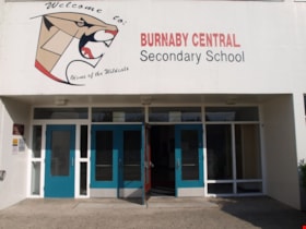
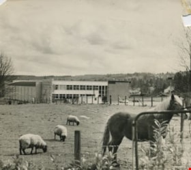
Burnaby Central School
https://search.heritageburnaby.ca/link/landmark814
- Repository
- Burnaby Heritage Planning
- Geographic Access
- Canada Way
- Associated Dates
- 1958
- Heritage Value
- Burnaby Central School became the third high school to be built in Burnaby (following Burnaby North and Burnaby South). The increased school enrolments due to the rapidly growing population in Burnaby meant that the School District required this third high school to be placed between the other two. In its first year, 719 students attended Burnaby Central.
- Historic Neighbourhood
- Burnaby Lake (Historic Neighbourhood)
- Planning Study Area
- Douglas-Gilpin Area
- Street Address
- 4939 Canada Way
- Street View URL
- Google Maps Street View
Images
Burnaby Municipal Hall
https://search.heritageburnaby.ca/link/landmark807
- Repository
- Burnaby Heritage Planning
- Geographic Access
- Canada Way
- Associated Dates
- 1956
- Heritage Value
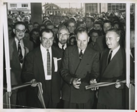
- When staff outgrew the municipal buildings at Edmonds and Kingsway, a debate erupted over where to build a new municipal hall. North Burnaby residents argued against the Kingsway and Edmonds site as it was too removed for their needs, but South Burnaby residents were not prepared to accept a hall in North Burnaby. The debate was finally resolved when it was suggested that the new civic centre for the municipality be in the exact geographic centre of Burnaby. Fortunately, this meant that the new hall was to be built near Deer Lake, in the beautiful Central Valley setting. Burnaby voters accepted this decision and approved the $625,000.00 it would take to build the new structure and the official opening ceremony was held June 22, 1956 when then Reeve Charles MacSorley received the keys to the hall from the contractor.
- Historic Neighbourhood
- Burnaby Lake (Historic Neighbourhood)
- Planning Study Area
- Douglas-Gilpin Area
- Street Address
- 4949 Canada Way
- Street View URL
- Google Maps Street View
Images
Burnaby Winter Club
https://search.heritageburnaby.ca/link/landmark816
- Repository
- Burnaby Heritage Planning
- Geographic Access
- Canada Way
- Associated Dates
- 1956
- Heritage Value
- Skating on Deer Lake and Burnaby Lake was the inspiration to form the Burnaby Winter Club in the 1950s. In 1958, the volunteer group opened an indoor ice facility, still operating today at 4990 Canada Way. Originally, the facility boasted 8 sheets of curling ice, that were used to capacity by the more than 500 family and individual members in the heyday of the Club. The Winter Club was a social centre: in addition to curling, it was a popular place for banquets and dances, and a place for families to spend time together. In the 1960s, the eight sheets of curling ice were reduced to five, to make room for a sheet of hockey ice for the members’ children. Volunteer coaches were committed to excellence, and the Club produced many professional hockey players. By 1964, the Club’s first future NHL player was playing: Pee Wee player Jack McIlhargey.
- Historic Neighbourhood
- Burnaby Lake (Historic Neighbourhood)
- Planning Study Area
- Douglas-Gilpin Area
- Street Address
- 4990 Canada Way
- Street View URL
- Google Maps Street View
Images
Douglas-Gilpin Neighbourhood
https://search.heritageburnaby.ca/link/landmark799
- Repository
- Burnaby Heritage Planning
- Associated Dates
- 1955-2008
- Heritage Value
- The Douglas-Gilpin Neighbourhood developed into a diverse area incorporating residential, business, educational and park districts in the period after 1955. The BCIT site was built in the early 1960s, shortly after the Burnaby Municipal Hall was located on Canada Way near Deer Lake in 1956. The construction of the Municipal Hall at this location fostered the creation of an administrative and business centre adjacent to the park, while the northern and central areas of the neighbourhood retained their primarily residential character.
- Historic Neighbourhood
- Burnaby Lake (Historic Neighbourhood)
- Planning Study Area
- Douglas-Gilpin Area
Images
Lake City Neighbourhood
https://search.heritageburnaby.ca/link/landmark793
- Repository
- Burnaby Heritage Planning
- Associated Dates
- 1955-2008
- Heritage Value
- When Simon Fraser University opened in 1965, approximately sixteen industrial properties had been developed in the Lake City Industrial Park. In addition, significant tracts of land in the western portion had been pre-cleared and graded in anticipation of additional development, while most of the eastern half remained forested. Some of the early companies to locate in the area were Nabob Foods, Volkswagen Canada, British Columbia Television Broadcasting, Simpson Sears, and H.Y. Louie Company Limited. Both Imperial Oil and Shell Oil established petroleum storage and distribution facilities in the area. Initially a heavy industrial area, by 1979, single family neighbourhoods south of Lougheed Highway and west of Eagle Creek had been largely developed. By the mid1980's, the Burnaby 200 multi-family development along Forest Grove Drive had also been completed.
- Planning Study Area
- Lake City Area
Images
Morley-Buckingham Neighbourhood
https://search.heritageburnaby.ca/link/landmark829
- Repository
- Burnaby Heritage Planning
- Associated Dates
- 1955-2008
- Heritage Value
- In the 1980 "Residential Neighbourhood Environment Study," the Morley-Buckingham Neighbourhood is described as "perhaps Burnaby's most prestigious residential area. The lots are larger than most other areas of the Municipality and this, along with the new expensive housing developed over the past 10 years, has created a very desirable residential neighbourhood...The older area of Buckingham lies at the lower edge of the slope and here the homes and streets are more uniform and aged between 20 and 25 years old...to the east of Canada Way lies...a cluster townhouse development."
- Historic Neighbourhood
- Burnaby Lake (Historic Neighbourhood)
- Planning Study Area
- Morley-Buckingham Area
Images
Simpson-Sears
https://search.heritageburnaby.ca/link/landmark696
- Repository
- Burnaby Heritage Planning
- Geographic Access
- Kingsway
- Associated Dates
- 1954
- Heritage Value
- The Simpson-Sears store on Kingsway opened in 1954 and was the second Simpson-Sears to be located in British Columbia. The store helped to solidify the neighbourhood's growing reputation as a major commercial centre in the Lower Mainland and became a prototype for the company's large format stores across Canada.
- Historic Neighbourhood
- Central Park (Historic Neighbourhood)
- Planning Study Area
- Maywood Area
- Street Address
- 4700 Kingsway
Images
Trans Mountain Pipeline Company
https://search.heritageburnaby.ca/link/landmark685
- Repository
- Burnaby Heritage Planning
- Geographic Access
- Shellmont Street
- Associated Dates
- 1953
- Heritage Value
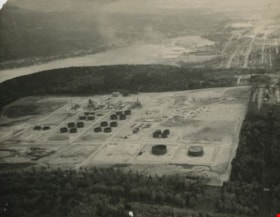
- On March 21, 1951 the Parliament of Canada granted the Trans Mountain Oil Pipe Line Company a charter. By May of the following year, the Corporation of Burnaby gave final reading to Bylaw No. 3203, which resulted in the conveyance of land in DL 142, 143 and 144 (Burnaby Mountain site) to the Trans Mountain Oil Pipe Line Company. Construction of the Burnaby Mountain tank farm was completed in October of 1953 and the site became operational as the first shipment of oil reached Trans Mountain’s Burnaby Terminal.
- Planning Study Area
- Lake City Area
- Street Address
- 8099 Shellmont Street
- Street View URL
- Google Maps Street View
Images
Willingdon Heights Neighbourhood
https://search.heritageburnaby.ca/link/landmark670
- Repository
- Burnaby Heritage Planning
- Associated Dates
- 1925-1954
- Heritage Value
- Willingdon Heights was another new subdivision developed in Burnaby during the post-World War Two building boom. A brochure about the development published in 1948 proclaimed "the Willingdon Heights 500 home development project in Burnaby fulfills its promise to provide a self-contained community for former members of the armed services and their families...the largest single veteran housing project in Canada as far as homes for individual ownership is concerned, Willingdon Heights development was planned by the Central Mortgage and Housing Corporation...At this date the earlier built rows of homes have passable roads and the owners are improving lawns and gardens in spare time...eventually additional stores and professional services will be installed and recreational projects will add to the amenities of a community of congenial residents..."
- Planning Study Area
- Willingdon Heights Area
Images
Willingdon Heights Neighbourhood
https://search.heritageburnaby.ca/link/landmark777
- Repository
- Burnaby Heritage Planning
- Associated Dates
- 1955-2008
- Heritage Value
- The convenient location of Willingdon Heights to the Trans Canada Highway, Lougheed Highway and Hastings Street has fostered its development as a primarily residential commuter neighbourhood. Characterised in the post-World War Two period by predominantly single-family developments, the neighbourhood has retained this identity despite some higher density apartment buildings now found there.
- Planning Study Area
- Willingdon Heights Area
Images
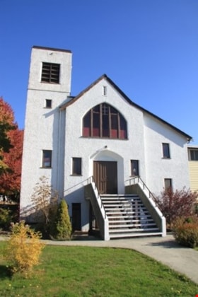
Willingdon Heights United Church
https://search.heritageburnaby.ca/link/landmark658
- Repository
- Burnaby Heritage Planning
- Description
- Church building.
- Associated Dates
- 1951
- Street View URL
- Google Maps Street View
- Repository
- Burnaby Heritage Planning
- Geographic Access
- Parker Street
- Associated Dates
- 1951
- Description
- Church building.
- Heritage Value
- This church was built to serve a 500-home subdivision known as Willingdon Heights–Canada’s largest single veteran’s housing project created by the Central Mortgage and Housing Corporation and constructed by the Whitsell Construction Company in 1948. The church building was designed as a simplified Gothic Revival church with a tall front tower and Gothic pointed-arch stained glass window and entrance. This church was designed by Vancouver architects Twizell & Twizell. Both Robert Twizell (1875-1964) and younger brother George Twizell (1885-1957) articled at Newcastle, England’s Hicks & Charlewood before arriving in Vancouver in late 1907 or early 1908, with George working for Robert until they established a partnership a few years later. Their firm lasted for nearly half a century and was well known for its numerous church designs.
- Locality
- Vancouver Heights
- Historic Neighbourhood
- Vancouver Heights (Historic Neighbourhood)
- Planning Study Area
- Willingdon Heights Area
- Architect
- Twizell & Twizell
- Area
- 1808.82
- Contributing Resource
- Building
- Ownership
- Private
- Street Address
- 4304 Parker Street
- Street View URL
- Google Maps Street View
Images
Hipman "Jimmy" Chow and Donna Polos fonds
https://search.heritageburnaby.ca/link/museumdescription19150
- Repository
- Burnaby Village Museum
- Date
- 1950-2022
- Collection/Fonds
- Hipman "Jimmy" Chow and Donna Polos fonds
- Description Level
- Fonds
- Physical Description
- 3 sound recordings (wav) + 1 sound recording (mp3) + 65 photographs + 26 photographs (jpg) + 1 portfolio (15 col. photographs + 12 col. laser prints) + 1 col. laser print + 6 business cards + 1 identification card + 1 booklet
- Scope and Content
- Fonds consists of an oral history interview with Jimmy Chow and his wife, Donna Polos; photographs of Jimmy Chow and his family soon after they immigrated to Canada in the 1950s as well as a sampling of photographs and records documenting Jimmy Chow's career in the film industry. Fonds is arranged…
- Repository
- Burnaby Village Museum
- Collection/Fonds
- Hipman "Jimmy" Chow and Donna Polos fonds
- Description Level
- Fonds
- Physical Description
- 3 sound recordings (wav) + 1 sound recording (mp3) + 65 photographs + 26 photographs (jpg) + 1 portfolio (15 col. photographs + 12 col. laser prints) + 1 col. laser print + 6 business cards + 1 identification card + 1 booklet
- Scope and Content
- Fonds consists of an oral history interview with Jimmy Chow and his wife, Donna Polos; photographs of Jimmy Chow and his family soon after they immigrated to Canada in the 1950s as well as a sampling of photographs and records documenting Jimmy Chow's career in the film industry. Fonds is arranged into series: 1) Jimmy Chow and Donna Polos interviews series 2) Jimmy Chow family photographs series 3) Property master photographs series 4) Property master records series
- History
- Hipman "Jimmy" Chow was born in Lin Pong Lee, Hoiping, China in 1948. In 1950, Jimmy Chow and his mother, Gim Gee Chow (1913-1991) fled China to escape the Communist Revolution and to be reunited with his father, Robin Chung Dip Chow (1906-1990) who’d immigrated to Canada many years earlier. Jimmy’s elder sister Shao-Lin Chow stayed behind in China. Jimmy’s father, Robin Chung Dip Chow immigrated to Canada in 1921 at 14 years of age and was forced to pay the Chinese head tax of $500. In 1950, Jimmy and his mother first fled to Hong Kong before immigrating to Canada and arriving in Vancouver. Jimmy Chow’s birth name is Hipman Chow but when he arrived in Canada, his father indicated that he needed an English name and he was given the name “Jimmy” but retained his birth name “Hipman Chow”. Over the years, Jimmy has also used the name “James H. Chow” and is often credited by this name in the film industry. For the first four years after immigrating, Jimmy and his parents lived in Manitoba, Saskatchewan and Quebec where his father had work in hotels and restaurants. While living in Asquith, Saskatchewan Jimmy attended school and began to learn English. In 1954, Jimmy and his parents returned to Vancouver, first living in the area of Strathcona before settling in the neighbourhood of Mount Pleasant where they purchased a house located on 15th Avenue east of Main Street. While living in Mount Pleasant, Jimmy attended both elementary and high school. While attending high school, Jimmy began working at the local grocery store where he worked for many years living at home and saving his money. In 1970 while attending Vancouver City College, Jimmy met his future wife Donna Polos. Two years later, they moved in together, married in 1981 and started a family. Jimmy and Donna first lived in North Burnaby before purchasing a house on Victory Street in Burnaby where they raised their three children. Growing up in a traditional Chinese Canadian family, Jimmy was always one who went against the grain. Although his father wanted him to get a business degree, Jimmy had aspirations for a different career path. Through the referral of a friend, he entered the film industry in 1973 working for CBC Vancouver. While working at the CBC, Jimmy gained valuable experience working on the set of the television series The Beachcombers, which launched his career in the film industry. Over a 45 year career, Jimmy worked on over 50 blockbuster movies, historical period films, science fiction films and fantasy films, where he honed in on his expertise as a set decorator, art director and property master. He built an international reputation through working with production companies, prop makers and antique sellers across the globe. As a property master in the film industry, Jimmy Chow has been responsible for designing, managing, and sourcing props for films such as: The BFG, Warcraft: The Beginning, X-Men 2, Fantastic Four, Watchman, Tron: Legacy, Little Women, Seven Years in Tibet, Shanghai Noon, The Shipping News, Fantastic Four: Rise of the Silver Surfer, The Changeling, Man of Steel (Superman), Snow Falling on Cedars, Legends of the Fall, And the Sea Will Tell, Once a Thief and many more. With Jimmy's many years of professional experience in the film industry, he has been a union member of IATSE (International Alliance of Theatrical Stage Employees, Moving Picture Technicians...) from July 1979, a member of the Academy of Motion Picture Arts and Science from 2018 and has worked as a guest lecturer in film production at Capilano University and Langara University. He was also a key contributor to the Burnaby Village Museum’s 2014 temporary exhibition Burnaby Makes Movies. Donna Polos was born in Vancouver in 1949 to parents Mayme "May" Helen Tillikana Polos (1931-1977) and Donald James Polos (1926-2017). Donna’s maternal grandparents, Elvi Tienhara and Toiva Tillikana immigrated to Canada from Helsinki, Finland. Donna’s paternal grandmother, Pauline Chimiki Polos emigrated from Ukraine to Argentina and then to Winnipeg. Donna’s paternal grandfather, James "Jimmy" Kostopolus emigrated as an orphan from Sparta Greece at the age of 12 years. In 1908, he first immigrated to the United States where he was denied entry so immigrated to Canada, entering through Halifax at Pier 17. When immigrating, James changed his last name to "Polos". Jimmy Polos arrived in Halifax with only five dollars in his pocket. He lived in Halifax for many years before making his way to Vancouver where he established three restaurants and raised his family. James was the proprietor of three restaurants in Burnaby including; the Home Apple Pie Café (1941-1944) located on East Hastings near Princess Avenue; Jimmy’s Café (1945-1955) located on East Hastings near Hawks Avenue and another restaurant located near 10th Avenue and Alma Street. Donna grew up with her family in Vancouver, first living in the downtown eastside before moving to a home near Joyce Station. Donna attended elementary school and high school while growing up in the neighbourhood of Joyce Station. Donna moved out of her family home at 21 years of age and lived with roommates before moving in with Jimmy Chow in 1972. Donna attended Vancouver City College and the University of British Columbia where she obtained her teaching degree in 1974. Donna first taught at Gilmore Elementary School before being hired to teach at Clinton Elementary School where she taught for nine years. While raising their three children, Donna worked part time teaching in schools in Burnaby. In 1991, after a near death experience, Donna became interested in fine art and took drawing and watercolour painting classes. This experience led her to experimenting with different painting techniques on paper and fabric. In 2008, Donna retired from teaching but continued her art career often working as an Artist in Residence at various schools and exhibiting her work. While living in Burnaby Donna has been politically active with a particular passion for heritage, housing and preserving the natural environment. Donna was instrumental in advocating and petitioning for the establishment of a tree bylaw in Burnaby which was eventually adopted by the City.
- Creator
- Chow, Hipman "Jimmy"
- Polos, Donna
- Accession Code
- BV022.21
- BV023.11
- Date
- 1950-2022
- Media Type
- Sound Recording
- Photograph
- Textual Record
- Graphic Material
- Notes
- Title based on contents of fonds
- Hipman "Jimmy" Chow's name in Cantonese is Chow Hipman and in Mandarin is Zhou Xiamin.
Personal material
https://search.heritageburnaby.ca/link/archivedescription82732
- Repository
- City of Burnaby Archives
- Date
- [1910-1978]
- Collection/Fonds
- Hazel Simnett collection
- Description Level
- File
- Physical Description
- 9 paintings : colour print, 2 photographs : b&w, and 1 folder of textual records
- Scope and Content
- File consists of application for a driver's license, Kingsway Driving School report card, driver's examination receipt and a letter addressed to Hazel Simnett from the Victorian Order of Nurses for Canada. Also included is an immigration inspection card of Fred Simnett aboard the S.S. Lake Champlai…
- Repository
- City of Burnaby Archives
- Date
- [1910-1978]
- Collection/Fonds
- Hazel Simnett collection
- Physical Description
- 9 paintings : colour print, 2 photographs : b&w, and 1 folder of textual records
- Description Level
- File
- Record No.
- MSS167-008
- Accession Number
- 2013-22
- Scope and Content
- File consists of application for a driver's license, Kingsway Driving School report card, driver's examination receipt and a letter addressed to Hazel Simnett from the Victorian Order of Nurses for Canada. Also included is an immigration inspection card of Fred Simnett aboard the S.S. Lake Champlain from Liverpool and a letter from the Office of the Mayor addressed to Mary Ann Simnett for her ninetieth birthday. Also included is a photograph (see item 559-001). Also included are newsclippings regarding Robert Burnaby and the "Bygones of Burnaby" book, a programme of the Robert Burnaby Commemorative Dinner, a photocopy of "The Argus" (Burnaby South High School's newspaper) from 1938, a programme from Madys Pridmore Brown's Variety Programme, "The Buzzer" Volume 40 Issue 16 advertising Vancouver street cars, New Vista Society certificate addressed to Hazel Simnett, an envelope of Fenwick Lansdowne bird prints from 1957 and a print of the Royal Family found in a cardboard envelope postmarked 1972.
- Subjects
- Arts - Paintings
- Documentary Artifacts - Newspapers
- Documentary Artifacts - Photographs
- Performances - Concerts
- Organizations - Societies and Clubs
- Personal Symbols - Certificates
- Transportation
- Persons - Royalty
- Media Type
- Textual Record
- Photograph
- Graphic Material
- Notes
- Title based on note accompanying file on folder ; The Argue was stapled together
- Simnett personal papers series
- Historic Neighbourhood
- Alta-Vista (Historic Neighbourhood)
- Planning Study Area
- Clinton-Glenwood Area
