George & Mary Buxton Residence
- Repository
- Burnaby Heritage Planning
- Geographic Access
- Buxton Street
- Associated Dates
- c.1912
- Description
- Residential building.
- Heritage Value
- George Searby Buxton (1867-1955), an English-born carpenter, built this Arts and Crafts dwelling and resided here with his wife and local teacher Mary Isabel Buxton (née Nattriss, 1865-1941). George and Mary are both buried in the picturesque St. Helen’s Anglican Church cemetery in Surrey. The house retains this style’s characteristic elements such as half-timbering, an oriel window and turned verandah supports, as well as its distinctive windows, which are casements in the lower portion of the frame and a fixed multi-paned sash in the upper. The original siding has been covered with a later coat of stucco. The house survives in well-maintained condition.
- Locality
- Central Park
- Historic Neighbourhood
- Central Park (Historic Neighbourhood)
- Planning Study Area
- Marlborough Area
- Area
- 868.85
- Contributing Resource
- Building
- Ownership
- Private
- Street Address
- 4807 Buxton Street
- Street View URL
- Google Maps Street View
Less detail
Henry Adams Residence
- Repository
- Burnaby Heritage Planning
- Geographic Access
- Buxton Street
- Associated Dates
- c.1913
- Description
- Residential building.
- Heritage Value
- Carpenter Henry J. Adams constructed this side-gabled, shingle-clad bungalow circa 1913, with his neighbour, George S. Buxton (1867-1955), who was also a carpenter. The house is distinguished by its beautifully-detailed wraparound verandah, which is supported by square, tapered columns, and its distinctive semicircular window in the projecting front gable. Other details include a subtly flattened arched opening under the gable, leading to the central front entry.
- Historic Neighbourhood
- Central Park (Historic Neighbourhood)
- Planning Study Area
- Marlborough Area
- Area
- 864.56
- Contributing Resource
- Building
- Ownership
- Private
- Street Address
- 4826 Buxton Street
- Street View URL
- Google Maps Street View
Less detail
Central Park Neighbourhood
- Repository
- Burnaby Heritage Planning
- Associated Dates
- 1925-1954
- Heritage Value
- Although still largely a rural area during the 1920s, subdivisions began appearing in the Central Park neighbourhood at this time. Development was slowed by the Great Depression of the 1930s but the influx of commercial buildings and new housing initiatives in the post-war boom led to a period of rapid growth especially in the Garden Village subdivision which was undertaken in 1953 with the plan to build 500 modern homes in the 140-acre site. Despite the closure of the interurban line in 1953, the neighbourhood remained an active commercial and residential centre.
- Historic Neighbourhood
- Central Park (Historic Neighbourhood)
- Planning Study Area
- Maywood Area
Less detail
Central Park Neighbourhood
- Repository
- Burnaby Heritage Planning
- Associated Dates
- 1891-1904
- Heritage Value
- Central Park was one of the first and fastest-growing communities in Burnaby. Located along the electric tram line and the Vancouver Road (Kingsway), it was also chosen for a government settlement project referred to as the Central Park Small Holdings. The lands held by the Provincial Government were subdivided and sold around 1894 and by 1899 the settlement was large enough to warrant the construction of an Anglican Church there.
- Historic Neighbourhood
- Central Park (Historic Neighbourhood)
- Planning Study Area
- Maywood Area
Less detail
Central Park Neighbourhood
- Repository
- Burnaby Heritage Planning
- Associated Dates
- 1905-1924
- Heritage Value
- In 1906, Maxwell Smith, President of the Central Park Farmer's Institute gave a speech in which he commented on the growth of this district and its ideal location during the boom years after 1905. He said: "Central Park is destined to become the epicentre of a great commercial metropolis, when Vancouver and New Westminster will have both expanded and prospered until they meet and fill up the intervening distances with residences of a new city, greater than few can now imagine, even in their wildest flights of fancy...we are proud of the two cities that lie on either side of us but they are, but mere hamlets compared with the great city that is to be on this peninsula. The time is coming when there will be one vast city, one commercial metropolis, and Central Park will be the heart of it."
- Historic Neighbourhood
- Central Park (Historic Neighbourhood)
- Planning Study Area
- Maywood Area
Less detail
Garden Village Neighbourhood
- Repository
- Burnaby Heritage Planning
- Associated Dates
- 1955-2008
- Heritage Value
- Bounded by Moscrop Street to the north, Kingsway and Grange to the south, Willingdon to the east and Boundary Road to the west, the Garden Village Neighbourhood is characterised as a primarily residential area that is well-served due to its proximity to commercial, park and business centres. The north-east corner of the neighbourhood is a typical 1950s subdivision of mostly single family homes located on an irregular street pattern, while the remaining areas saw some transition to multi-family housing types throughout the 1970s and up to the current time.
- Historic Neighbourhood
- Central Park (Historic Neighbourhood)
- Planning Study Area
- Garden Village Area
Less detail
Maywood Neighbourhood
- Repository
- Burnaby Heritage Planning
- Associated Dates
- 1955-2008
- Heritage Value
- Burnaby's Maywood Neighbourhood consists of the Metrotown Town Centre - one of four Town Centres in the City. Metrotown is one of the region's most developed and fastest growing centres. It is served by the first SkyTrain line developed in the mid-1980s and anchored by B.C.'s largest shopping and entertainment complex. As an older centre that has progressively added new developments over the years, Metrotown offers a range of housing types and tenures from three-storey walk-up apartments to modern residential towers.
- Historic Neighbourhood
- Central Park (Historic Neighbourhood)
- Planning Study Area
- Maywood Area
Less detail
Marlborough Neighbourhood
- Repository
- Burnaby Heritage Planning
- Associated Dates
- 1955-2008
- Heritage Value
- The Marlborough Neighbourhood is another residential area that was witness to rapid growth and subdivision during the 1950s and 1960s, creating primarily single-family housing stock. In the 1970s and 1980s, as the commercial district around Kingsway grew, so too did higher density housing projects such as townhomes and condominiums.
- Historic Neighbourhood
- Central Park (Historic Neighbourhood)
- Planning Study Area
- Marlborough Area
Less detail
Oakalla Neighbourhood
- Repository
- Burnaby Heritage Planning
- Associated Dates
- 1955-2008
- Heritage Value
- The phasing out and demolition of the Oakalla Prison farm allowed for the planned development of the Oakalla Neighbourhood in the 1980s. By 1991, the City of Burnaby had adopted the Oakalla Development Plan which called for the transfer of land to the Deer Lake Park reserve as well as the creation of a new residential area consisting of multi-family housing types.
- Historic Neighbourhood
- Central Park (Historic Neighbourhood)
- Planning Study Area
- Oakalla Area
Less detail
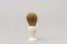
Shaving brush
- Repository
- Burnaby Village Museum
- Accession Code
- HV971.5.50
- Description
- Handheld shaving brush with a white plastic base and tan bristles. Used for mixing and applying shaving cream.
- Object History
- This item belonged to George Jeffery served as a Constable on the Burnaby Police Force from 1912 - 1935. His patrolled the large Central Park District on foot, stretching from Boundary to Royal Oak and Marine Drive to Moscrop. Over the coarse of his duties, Constable Jeffery saw the need for recreational activities in the area. He founded the Burnaby Athletic Association which featured a competitive boxing ring and gym. In 1935, when the Burnaby Police became the British Columbia Provincial Police, rather than leave the community he chose to leave the force. George Jeffery then worked at the nearby Oakalla Prison Farm until retiring in 1945.
- Category
- 03. Personal Artifacts
- Classification
- Personal Gear - - Personal Assistive Artifacts
- Object Term
- Brush
- Marks/Labels
- On the base of the brush "STERILIZED ADGER" "MADE IN" "CANADA" "PEERLESS" "PURE".
- Subjects
- Toilet Articles
- Names
- Jeffery, George
- Oakalla Prison Farm
- Historic Neighbourhood
- Central Park (Historic Neighbourhood)
- Planning Study Area
- Oakalla Area
Less detail
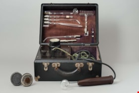
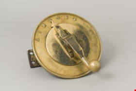
violet ray generator kit
- Repository
- Burnaby Village Museum
- Accession Code
- BV986.20.2
- Description
- Violet ray generator; box is black, silver corners, hinged lid, two hinged snap closures, black handle; inside lid is brown velvet with silver holders for glass tube attachments; plaque "CHAS.A.BRANSTON LIMITED"; in box left side is voltage dial, three black control knobs; right side is compartment for two cords, one with plug end, other with hollow brown bakelite? handle; with two discs on handles, two metal tubes, one roller with handle, metal rectangle, and red instruction booklet "THE BRANSTON VIOLET RAY HIGH FREQUENCY GENERATOR", illustrated; c. 1928
- Object History
- This is a Branston Violet Ray Generator. Branston’s claims were similar to those of other Violet Ray makers. Treatments are given for over a hundred ailments, ranging from abscess through appendicitis, colitis, diabetes, glaucoma, gonorrhoea, haemmorrhoids, impotence, laryngitis, mumps, pyorrhea, tuberculosis, ulcers, wrinkles and even writer’s cramp.
Electrical medical devices like this one were popular for decades among physicians, irregular practitioners, and home users, who could purchase them through catalogs and drugstores. The machine plugs into an electrical wall outlet. A glass electrode plugs into the wand, produces a violet glow, and delivers a spark when touched to the skin. The strength of the spark, controlled by the voltage selector, ranges from mild to quite intense. Attachments could stimulate many body parts.
- Category
- 05.Tools & Equipment for Science & Technology
- Classification
- Energy Production T&E - - Other Energy Production T&E
- Object Term
- Generator
- Maker
- Chas. A. Branston Limited
- Weston Electrical Instrument Corporation
- Subjects
- Electrical and Magnetic Tools and Equipment
- Occupations - Pharmacists
- Historic Neighbourhood
- Central Park (Historic Neighbourhood)
- Planning Study Area
- Douglas-Gilpin Area
Less detail
product package; cigar box
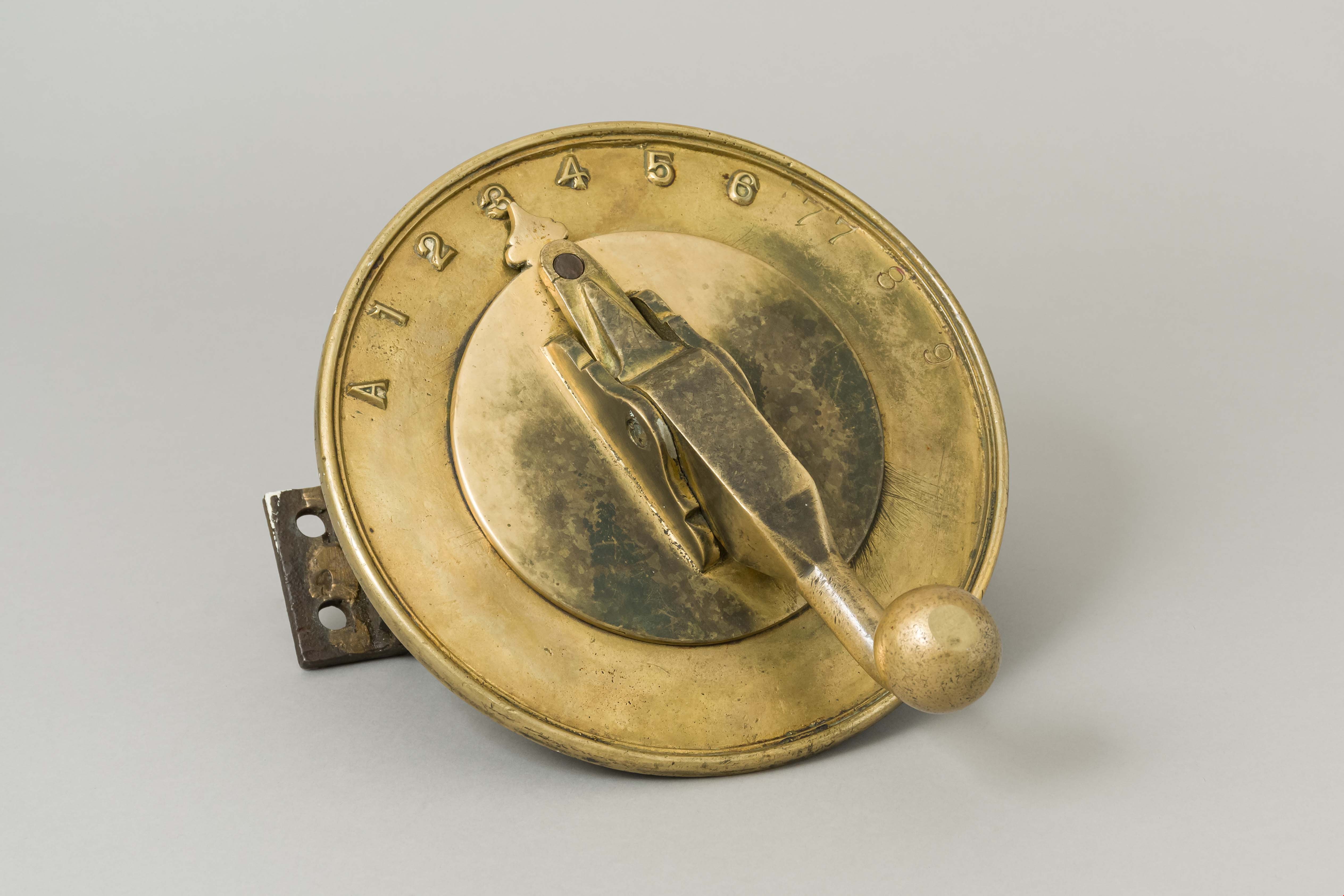
controller
- Repository
- Burnaby Village Museum
- Accession Code
- BV991.45.66
- Description
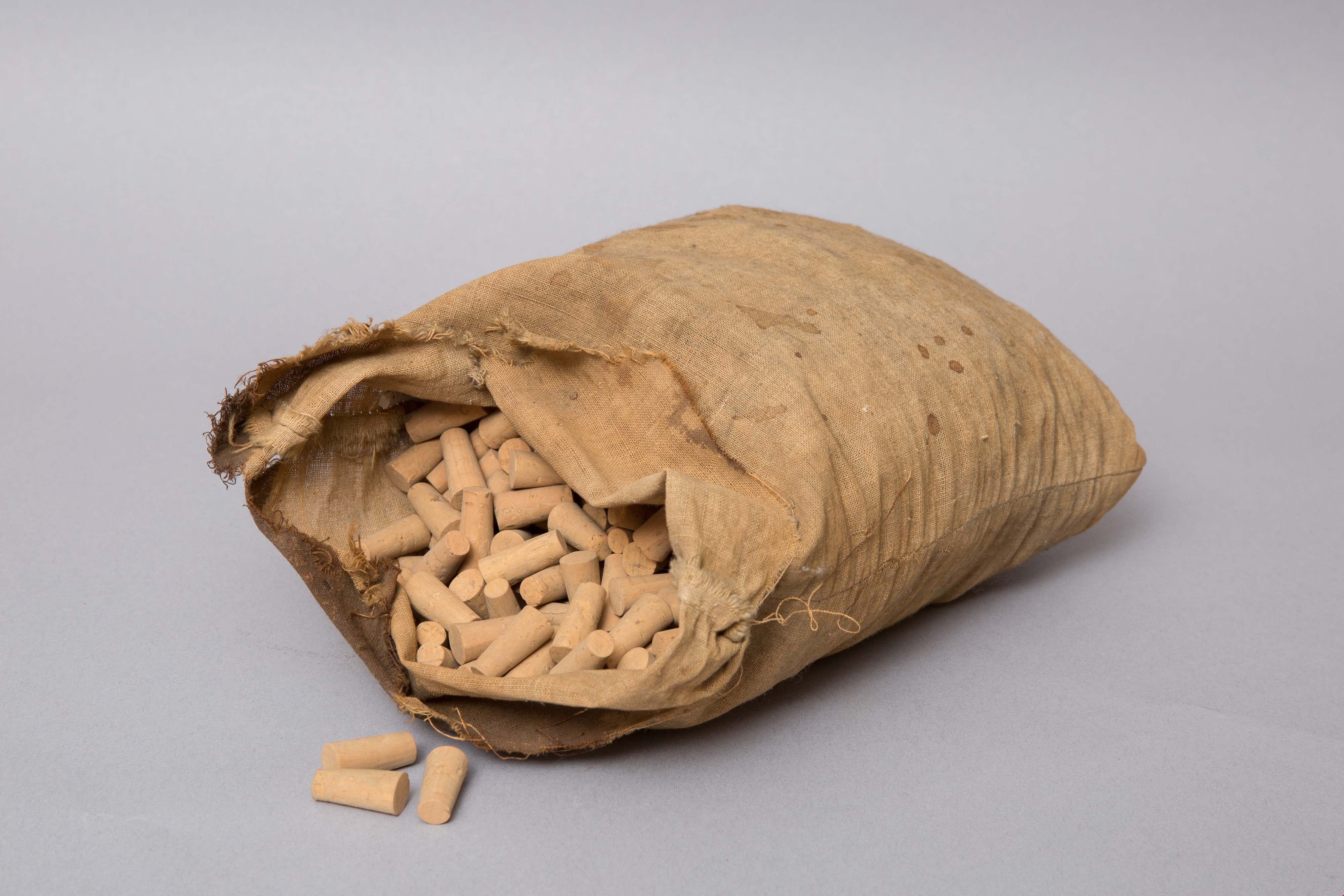
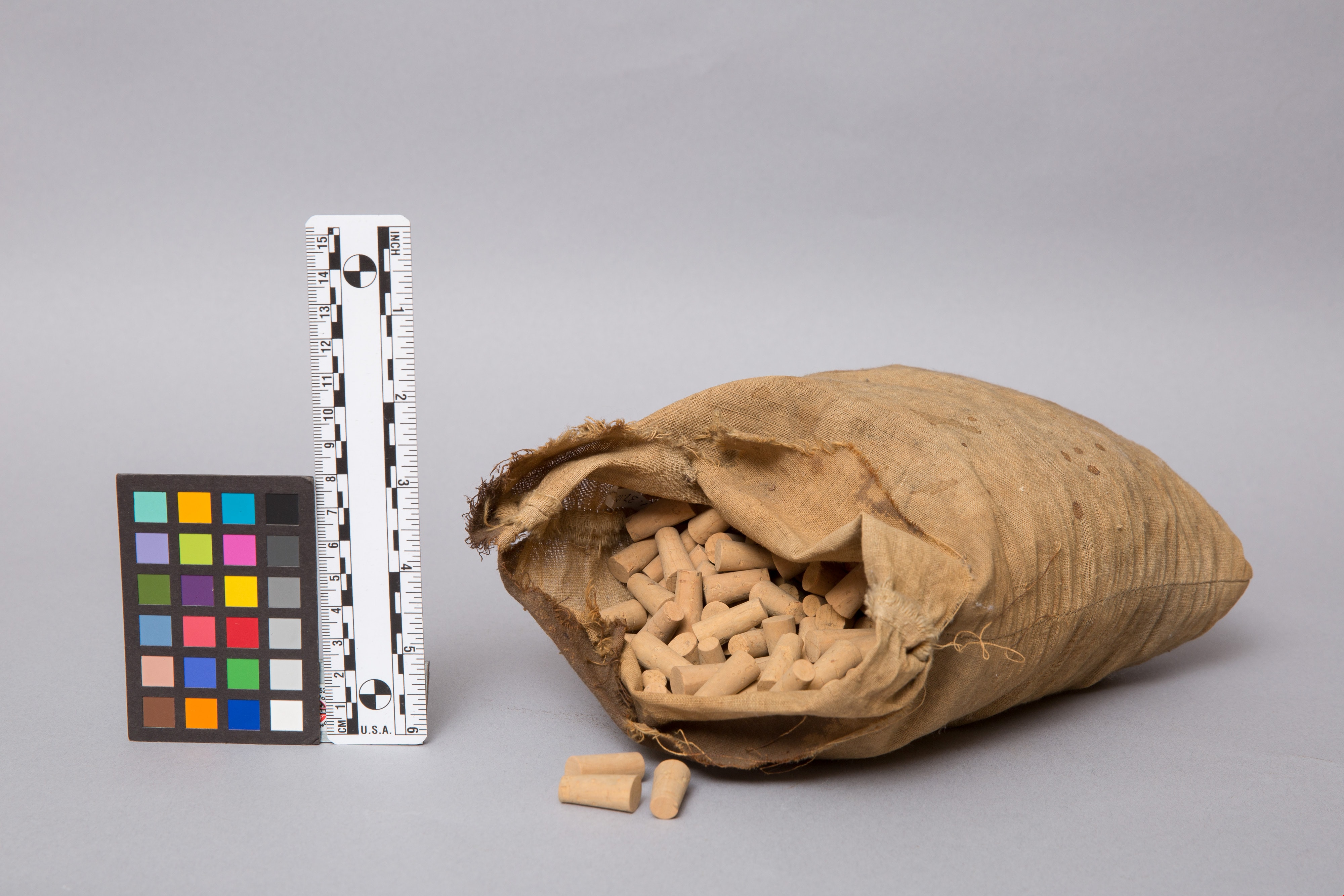
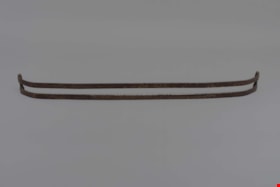
- A brass and steel controller used for opening and closing cell doors at Oakalla Prison. The top is composed of a brass plate and is round in shape. A brass handle is present in the center of the plate and rotates to aim a pointer at any of numbers 1 to 9 and the letter A at the beginning of the numbers. The handle is spring loaded and can rotate whenever it is pushed down releasing it from a pin. Under this brass plate are two steel gears held within a steel frame all of which are held together with locking nuts.
Markings on the top of the brass plate: "A" and the numbers in consecutive order from "1" to "9" . The numbers 7, 8 and 9 have been stamped in and appear to have been added later whereas the numbers "1" to "6" are present in raised format. The number "7" appears twice likely since the handle only locks at that point in between the two "7s"
Markings on the small gear: "KANA" "NK 40B 15".
- Reference
- See locking photograph of locking system that this controller came from: Q:\51305 BVM Collections\51305-05 Acquisitions\_DigitalAssets\1991\1991_0045_0662_001.tif
- Category
- 01. Built Environment Objects
- Classification
- Building Components - - Door & Window Elements
- Object Term
- Element, Door
- Measurements
- Overall measurements: Length: 24.8 cm Width: 22.5 cm Height: 18.9 cm
- Subjects
- Public Services - Correctional
- Names
- Oakalla Prison Farm
- Historic Neighbourhood
- Central Park (Historic Neighbourhood)
- Planning Study Area
- Oakalla Area
Less detail
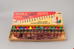
christmas lights in package
- Repository
- Burnaby Village Museum
- Accession Code
- BV993.53.20
- Description
- String of 15 Christmas tree lights, with cardboard holder and box; lights have patented bead holding lamps in position on tree, and connector on one end of string to plug in additional strings; holder keeps lights in place during storage; lid of box says, "NOMA" "15 Light DECORATIVE OUTFIT" "with 120 Volt MAZDA Lamps"; lid is red and yellow, string of coloured lights sep- arating sections; circle with enlarged bulb, "PATENTED BEAD..."; "EACH LAMP BURNS INDEPENDENTLY"; around edges, "No more searching..."; one end, "CAT. No. 3415"; three corners broken, "Price 5.50 ea." on lid in crayon
- Object History
- These items are from the Bailey family home at 6080 Kathleen Street (built in 1922) in the Central Park area. The lights are circa 1950s.
- Category
- 05.Tools & Equipment for Science & Technology
- Classification
- Lighting Equipment - - Lighting Devices
- Object Term
- Light, String
- Subjects
- Holidays - Christmas
- Lighting Devices
- Historic Neighbourhood
- Central Park (Historic Neighbourhood)
- Planning Study Area
- Maywood Area
Less detail
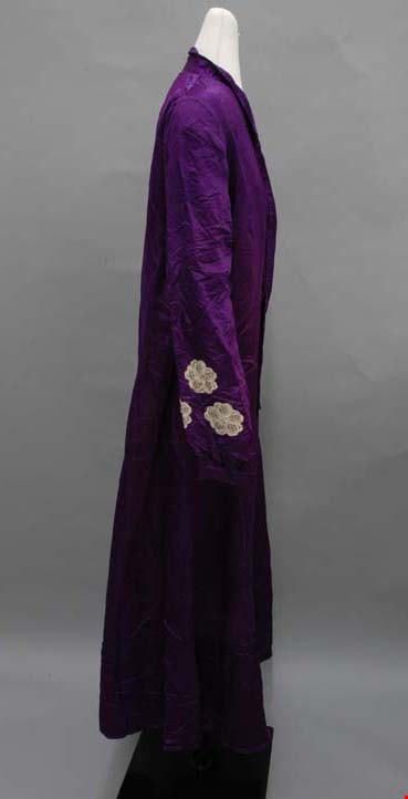
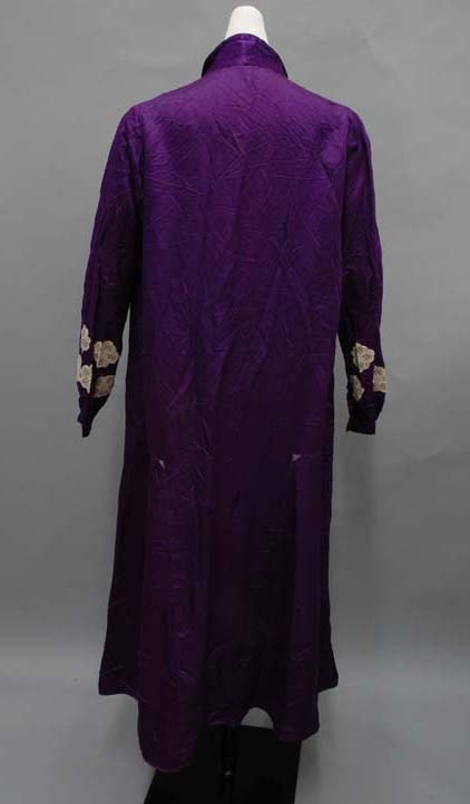
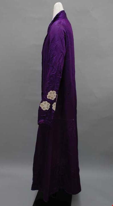
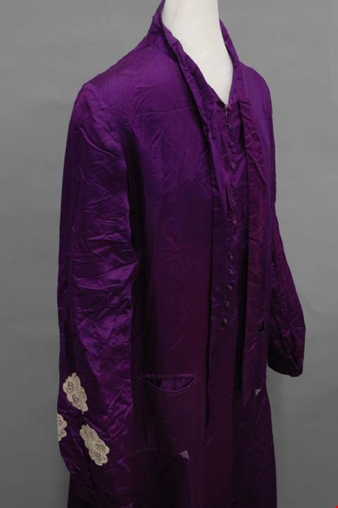
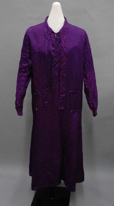
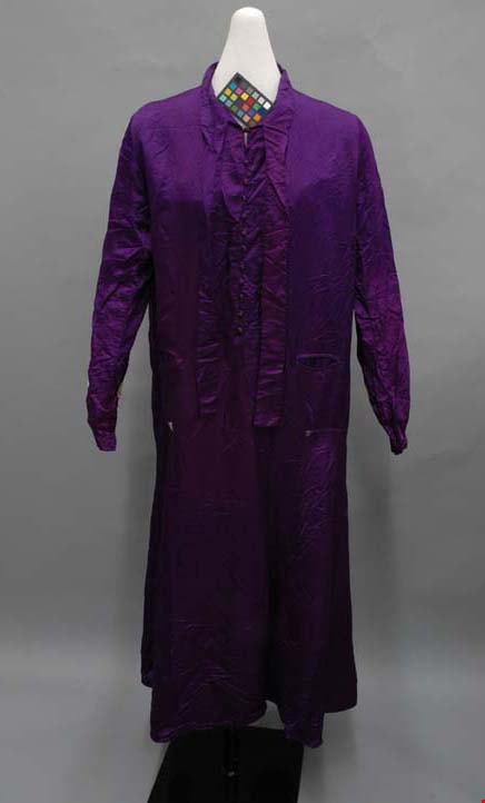
dress
- Repository
- Burnaby Village Museum
- Accession Code
- BV004.21.6
- Description
- Dress, c.1920. Purple silk satin with lace applique on sleeves. High collar with bow, buttons centre front, slightly flared ankle length skirt. Bias side panels on skirt.
This dress seems characteristic of an item that would appeal to its particular owner. Born in 1880, she is following 1920s trends somewhat with the straight cut and bias skirt inserts, but also staying true to the fashion of her youth that she is comfortable with: a high collar, longer skirt, scarf, and lace applique are all borrowed from her time in the belle epoque.
Extending from the stand collar are two long ties that could be tied into a bow or square knot. Directly under this at centre front is the opening with thirteen self fabric covered buttons. There is a bust dart on each side front, and a welt pocket on each side front just above the hips.
At a dropped waist, there is a somewhat flared gore on each side of the skirt that extends from side front to back. The skirt extends to just above the ankles, with a small double fold hem. Inside, the dress is unlined; its seams are finished with a whip stitch. The garment was likely made by its owner.
- Object History
- Object was inherited by the donor ca. 1974. She was given it by her mother, who had inherited it from her own mother, Elizabeth (Babb) Heaney.
- Colour
- Purple
- Subjects
- Clothing
- Clothing - Costumes
- Historic Neighbourhood
- Central Park (Historic Neighbourhood)
- Planning Study Area
- Maywood Area
Less detail
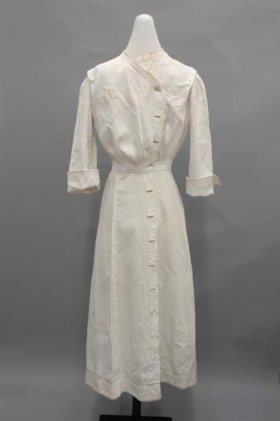
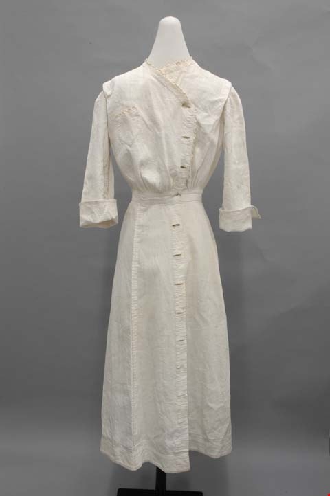
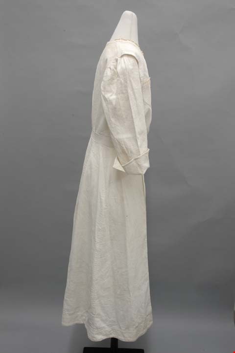
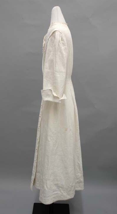
dress
- Repository
- Burnaby Village Museum
- Accession Code
- BV004.21.7
- Description
- Dress, c.1914-1918. White cotton pique. Calf length, three quarter length sleeves, buttons down centre front and up to neckline, waistband and cuffs.
The tight collar is edged with a scalloped trim; the right side of the collar extends diagonally to the right, making a slight V neck, and turns down the centre front. The trim follows the line to the waistband. At each shoulder just before the sleeve, there is a pleat that opens up. On the front at the waistband, there is some gathering in the waistband, and some small pleats at centre back. On the bodice front right, there is a small pocket that ends in a triangle shape and is topped with scalloped edging.
The sleeves are plain set-in, with fairly wide cuffs that turn up and are left open at the side.
Down the whole centre front there is an opening. Each side has holes, but no buttons remain: on the right, regular button holes and on the left, small bound holes.
The waistband is a two inch strip. Attached is the skirt in six slightly flared gores.
- Object History
- Object was inherited by the donor ca. 1974. She was given it by her mother, who had inherited it from her own mother, Elizabeth (Babb) Heaney.
- Colour
- White
- Subjects
- Clothing
- Clothing - Costumes
- Historic Neighbourhood
- Central Park (Historic Neighbourhood)
- Planning Study Area
- Maywood Area
Less detail


.jpg)