Narrow Results By
Subject
- Advertising Medium - Signs and Signboards 2
- Animals 1
- Animals - Fish 2
- Arts - Paintings 1
- Buildings - Religious - Churches 1
- Buildings - Residential - Apartments 1
- Buildings - Residential - Houses 6
- Buildings - Residential - Townhouses 1
- Buildings - Schools 10
- Construction Tools and Equipment 4
- Crafts 1
- Education 2
Person / Organization
- Burnaby Fish and Game Club 1
- Burnaby Mountain Secondary School 6
- Burnaby North High School 1
- Burnaby South High School 1
- Lougheed Town Centre 1
- Lyndhurst Elementary School 3
- Mann, Lillian 8
- Ritchie, Mike 1
- Sapperton Fish & Game Club 2
- Stiglish, Diane 1
- Stoney Creek Elementary School 6
- St. Stephen's Anglican Church 1

Trail through the woods of Stoney Creek School
https://search.heritageburnaby.ca/link/archivedescription58924
- Repository
- City of Burnaby Archives
- Date
- ca.1980
- Collection/Fonds
- Columbian Newspaper collection
- Description Level
- Item
- Physical Description
- 1 photograph : b&w ; 25.5 x 20.5 cm
- Scope and Content
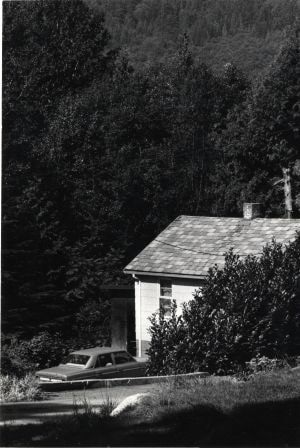
- Photograph of a paved trail through the woods by Stoney Creek Community School. A parking lot with cars is visible at the end of the trail.
- Repository
- City of Burnaby Archives
- Date
- ca.1980
- Collection/Fonds
- Columbian Newspaper collection
- Physical Description
- 1 photograph : b&w ; 25.5 x 20.5 cm
- Description Level
- Item
- Record No.
- 480-1375
- Access Restriction
- No restrictions
- Reproduction Restriction
- Reproduce for fair dealing purposes only
- Accession Number
- 2009-01
- Scope and Content
- Photograph of a paved trail through the woods by Stoney Creek Community School. A parking lot with cars is visible at the end of the trail.
- Media Type
- Photograph
- Photographer
- King, Basil
- Notes
- Title based on contents of photograph
- Note on recto reads: "Trail thru woods & Stoney Creek School"
- Note on verso reads: "PMT 100% / page 1 / Burnaby Today"
- Photographer's stamp on verso
- Street Address
- 2740 Beaverbrook Crescent
- Historic Neighbourhood
- Burquitlam (Historic Neighbourhood)
- Planning Study Area
- Lyndhurst Area
Images


Burquitlam Neighbourhood
https://search.heritageburnaby.ca/link/landmark703
- Repository
- Burnaby Heritage Planning
- Associated Dates
- 1925-1954
- Heritage Value
- By the 1950s, the Burquitlam Neighbourhood was becoming a residential and commercial centre for the northeast section of Burnaby. The Sullivan Heights area was developed as a single-family residential area with the Lyndhurst School opening in 1954. The completion of the Lougheed Highway in 1953 encouraged more commercial and retail development and fostered the growth of the neighbourhood throughout this period.
- Historic Neighbourhood
- Burquitlam (Historic Neighbourhood)
- Planning Study Area
- Lyndhurst Area
Images


Burquitlam Neighbourhood
https://search.heritageburnaby.ca/link/landmark734
- Repository
- Burnaby Heritage Planning
- Repository
- Burnaby Heritage Planning
- Heritage Value
- Burnaby's first non-Native settler, William Holmes, selected land near the Brunette River on which to build his home in 1860. From this beginning, the neighbourhood of Burquitlam developed, fostered by its proximity to the North Road trail which linked it to New Westminster. In 1906, the Burquitlam Post Office opened and in 1910 the Hamilton Road school opened to serve the growing population of children in the area.
- Historic Neighbourhood
- Burquitlam (Historic Neighbourhood)
- Planning Study Area
- Cameron Area
- Lyndhurst Area
Images

Burquitlam Neighbourhood
https://search.heritageburnaby.ca/link/landmark757
- Repository
- Burnaby Heritage Planning
- Associated Dates
- 1905-1924
- Heritage Value
- In 1921, the pamphlet "Beautiful Burnaby" was produced and it described the Burquitlam neighbourhood as such: "No part of Burnaby has more consistently laboured to advance its prosperity than Burquitlam. Enterprise and intelligence has hewn homes from the forest and developed land into highly productive gardens and poultry ranches. Burquitlam is the growing suburb to the north of the City of New Westminster. It is reached by the Sapperton carline direct from Edmonds being only a few minutes ride from New Westminster market. It is also served by the B.C.E.R. Burnaby Lake line and adjoins on the best golf links in Greater Vancouver."
- Historic Neighbourhood
- Burquitlam (Historic Neighbourhood)
- Planning Study Area
- Cameron Area
- Lyndhurst Area
Images

Lyndhurst Neighbourhood
https://search.heritageburnaby.ca/link/landmark823
- Repository
- Burnaby Heritage Planning
- Associated Dates
- 1955-2008
- Heritage Value
- The Lyndhurst Neighbourhood falls within the Lougheed Town Centre area - one of four Town Centres in Burnaby. The Lyndhurst Neighbourhood accounts for a significant portion of the residential component of the Town Centre. To the east of Stoney Creek Park, lies the Sullivan Heights single family subdivision which was built in the 1950s. To the west of the park, is a higher-density residential area consisting of multi-family buildings that were developed after 1974.
- Historic Neighbourhood
- Burquitlam (Historic Neighbourhood)
- Planning Study Area
- Lyndhurst Area
Images


St. Stephen's Anglican Church
https://search.heritageburnaby.ca/link/landmark765
- Repository
- Burnaby Heritage Planning
- Geographic Access
- Cameron Street
- Associated Dates
- 1913
- Heritage Value
- The site of St. Stephen's Anglican Church is one of the historic landmarks of old Burquitlam. Originally this was part of the Alexander and Ethel Evans farm, Saint Phillians. Initial services for the church were held in the Evans home and later in the Burquitlam school. Alexander Evans donated this site to the Anglican Church in trust with the wish that it become a future church and consecrated ground for a family burial plot. In 1913, the parish raised the funds to build the first church. St. Stephen's was consecrated by Bishop de Pencier on September 28, 1913.
- Historic Neighbourhood
- Burquitlam (Historic Neighbourhood)
- Planning Study Area
- Lyndhurst Area
- Street Address
- 9887 Cameron Street
- Street View URL
- Google Maps Street View
Images


Municipality of Burnaby - Volume XVI and Volume XVII
https://search.heritageburnaby.ca/link/museumdescription8684
- Repository
- Burnaby Village Museum
- Date
- May 1927
- Collection/Fonds
- Burnaby Village Museum Map collection
- Description Level
- File
- Physical Description
- 4 plans on 4 sheets : col. lithographic prints ; 63.5 x 53.5 cm folded to 53 x 31.5 cm
- Scope and Content
- File consists of four pages of plans removed from a bound book containing a series of fire insurance plans of the Municipality of Burnaby. Page "D" is titled: "GREATER VANCOUVER B.C. / VOLUME XVI / Surveyed _ May 1927 / MUNICIPALITY OF / BURNABY / PLAN DEPT. FIRE BRANCH _ B.C. INSURANCE UNDERWRITE…
- Repository
- Burnaby Village Museum
- Collection/Fonds
- Burnaby Village Museum Map collection
- Description Level
- File
- Physical Description
- 4 plans on 4 sheets : col. lithographic prints ; 63.5 x 53.5 cm folded to 53 x 31.5 cm
- Material Details
- Scale [1:1200] and [1:6000]
- Scope and Content
- File consists of four pages of plans removed from a bound book containing a series of fire insurance plans of the Municipality of Burnaby. Page "D" is titled: "GREATER VANCOUVER B.C. / VOLUME XVI / Surveyed _ May 1927 / MUNICIPALITY OF / BURNABY / PLAN DEPT. FIRE BRANCH _ B.C. INSURANCE UNDERWRITERS ASSN." / KEY PLAN". Plans covered in this "Key Plan" are numbered 1601 to 1626, 1632 and 1651 covering District Lots: 15; 31; 100 to 102; 114; 141 to 144; 147 and 148; 209 to 214. Plan "E" is part of "GREATER VANCOUVER B.C. / VOLUME XVII / Municipality of Burnaby / May 1927" and covers plans: 1701 to 1705; 1711 to 1715; 1723 to 1727; 1729 to 1733; 1737 to 1742 and District Lots: 68 to 74; 80 to 84; 32 to 35 and 38 to 39. Plan marked "F" is a key plan titled: "GREATER VANCOUVER B.C. / VOLUME XVII / Surveyed _ May 1927 / MUNICIPALITY OF / BURNABY and covers plans: 1706 to 1710; 1716 to 1722; 1734 and 1735; 1743 to 1752 and District Lots: 42 to 44; 59; 75 to 80; 83 to 87; 89 to 93 and 130. Plan "1729" is part of "GREATER VANCOUVER B.C. / VOLUME XVII / Municipality of Burnaby / May 1927" and covers District Lots 34 and 35.
- Responsibility
- British Columbia Underwriters' Association
- Accession Code
- HV972.111.6
- Access Restriction
- No restrictions
- Reproduction Restriction
- May be restricted by third party rights
- Date
- May 1927
- Media Type
- Cartographic Material
- Historic Neighbourhood
- Barnet (Historic Neighbourhood)
- Burquitlam (Historic Neighbourhood)
- Central Park (Historic Neighbourhood)
- Burnaby Lake (Historic Neighbourhood)
- Broadview (Historic Neighbourhood)
- Planning Study Area
- Burnaby Mountain Area
- Lyndhurst Area
- Lake City Area
- Cascade-Schou Area
- Garden Village Area
- Douglas-Gilpin Area
- Oakalla Area
- Scan Resolution
- 400
- Scan Date
- 2021-11-18
- Notes
- Title based on content of plans
- See also BV987.1.70d for revised versions of plans
- Scale is measured 1 inch = 500 feet
Zoomable Images


Municipality of Burnaby - Volume XV, Volume XVI, Volume XVII, Volume XVIII
https://search.heritageburnaby.ca/link/museumdescription8685
- Repository
- Burnaby Village Museum
- Date
- May 1927
- Collection/Fonds
- Burnaby Village Museum Map collection
- Description Level
- File
- Physical Description
- 4 plans on 4 sheets : col. lithographic prints ; 63.5 x 53.5 cm folded to 53 x 31.5 cm
- Scope and Content
- File consists of four pages of plans removed from a bound book containing a series of fire insurance plans of the Municipality of Burnaby. Plan "1531" is part of "GREATER VANCOUVER B.C. / VOLUME XV / Municipality of Burnaby / May 1927" and covers District Lots: 116 and 117. Key Plan "C" is part of …
- Repository
- Burnaby Village Museum
- Collection/Fonds
- Burnaby Village Museum Map collection
- Description Level
- File
- Physical Description
- 4 plans on 4 sheets : col. lithographic prints ; 63.5 x 53.5 cm folded to 53 x 31.5 cm
- Material Details
- Scale [1:600] and [1:1200]
- Scope and Content
- File consists of four pages of plans removed from a bound book containing a series of fire insurance plans of the Municipality of Burnaby. Plan "1531" is part of "GREATER VANCOUVER B.C. / VOLUME XV / Municipality of Burnaby / May 1927" and covers District Lots: 116 and 117. Key Plan "C" is part of "GREATER VANCOUVER B.C. / VOLUME XVI / Municipality of Burnaby / May 1927" and covers plans 1623 to 1651 and District Lots: 1 and 2; 4; 6; 8; 10 to 14; 25; 27; 40; 56 to 58; 88 and 89. Plan "1738" is part of "GREATER VANCOUVER B.C. / VOLUME XVII / Municipality of Burnaby / May 1927" and covers District Lots: 34 and 35. Key plan "G" is part of "GREATER VANCOUVER B.C. / VOLUME XVIII / Municipality of Burnaby / May 1927" and covers plans: 1801 to 1813; 1823; 1824; 1833 to 1838; 1841 to 1853 and District Lots: 32; 93; 94; 97 to 99; 149; 150; 152; 155 to 159; 161 to 164.
- Responsibility
- British Columbia Underwriters' Association
- Accession Code
- HV972.111.7
- Access Restriction
- No restrictions
- Reproduction Restriction
- May be restricted by third party rights
- Date
- May 1927
- Media Type
- Cartographic Material
- Historic Neighbourhood
- Central Park (Historic Neighbourhood)
- Fraser Arm (Historic Neighbourhood)
- Alta Vista (Historic Neighbourhood)
- Broadview (Historic Neighbourhood)
- Vancouver Heights (Historic Neighbourhood)
- Burquitlam (Historic Neighbourhood)
- East Burnaby (Historic Neighbourhood)
- Edmonds (Historic Neighbourhood)
- Lozells (Historic Neighbourhood)
- Planning Study Area
- Clinton-Glenwood Area
- Marlborough Area
- Maywood Area
- Windsor Area
- Big Bend Area
- Garden Village Area
- Willingdon Heights Area
- West Central Valley Area
- Cariboo-Armstrong Area
- Lyndhurst Area
- Cameron Area
- Lake City Area
- Edmonds Area
- Second Street Area
- Sperling-Broadway Area
- Lakeview-Mayfield Area
- Scan Resolution
- 400
- Scan Date
- 2021-11-18
- Notes
- Title based on content of plans
- See also BV987.1.70d for revised versions of plans
- Scale is measured 1 inch = 500 feet
Zoomable Images

Municipality of Burnaby - Volume XV, Volume XVI, Volume XVII, Volume XVIII, May 1927
Zoom into Image

Lyndhurst Elementary School
https://search.heritageburnaby.ca/link/landmark706
- Repository
- Burnaby Heritage Planning
- Geographic Access
- Lyndhurst Street
- Associated Dates
- 1953
- Heritage Value
- The Lyndhurst Elementary School was built in 1953 to replace the previous school - the Hamilton Road School - which had served the community since 1910.
- Historic Neighbourhood
- Burquitlam (Historic Neighbourhood)
- Planning Study Area
- Lyndhurst Area
- Street Address
- 9847 Lyndhurst Street
- Street View URL
- Google Maps Street View
Images

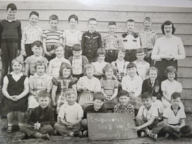
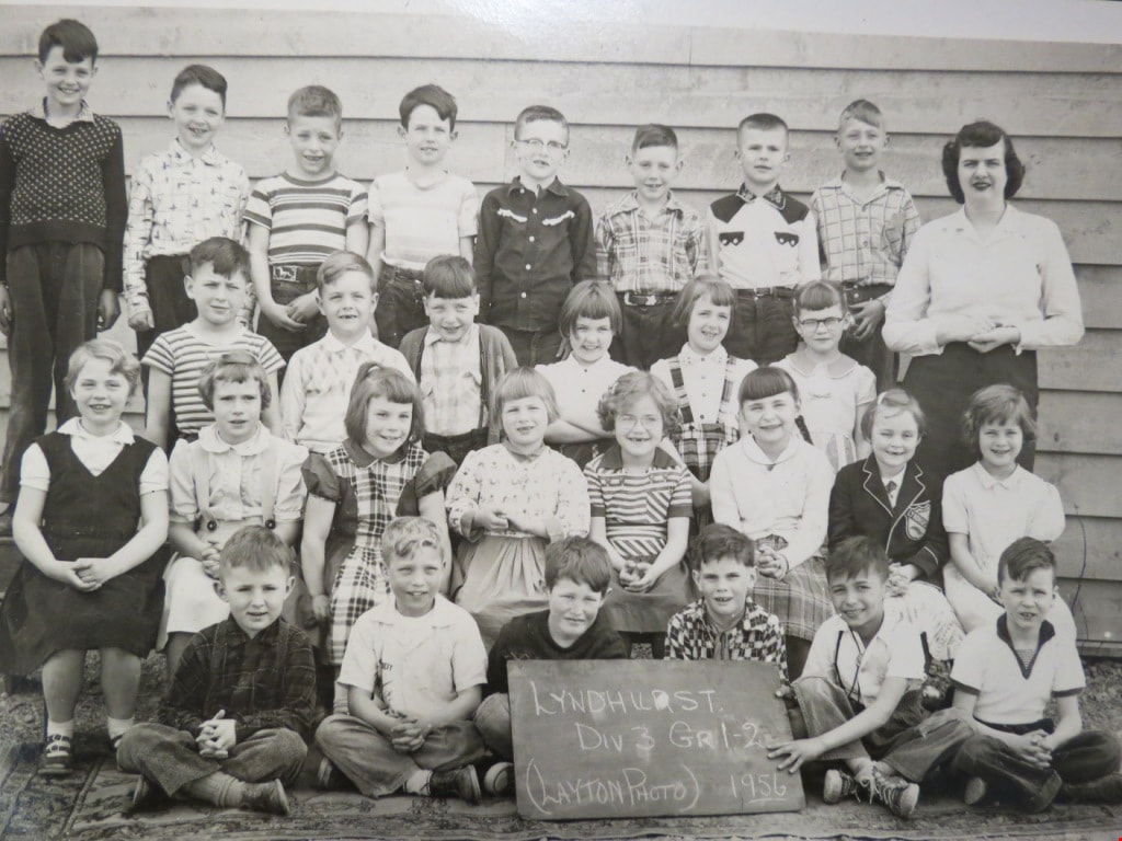
Lydhurst Elementary School class
https://search.heritageburnaby.ca/link/archivedescription76942
- Repository
- City of Burnaby Archives
- Date
- 1956 (date of original), digitally copied 2012
- Collection/Fonds
- Community Heritage Commission Special Projects fonds
- Description Level
- Item
- Physical Description
- 1 photograph (jpeg) : col. ; 300ppi
- Scope and Content
- Photograph of a Lydhurst Elementary School class. Diane Stiglish is seated in the second row, third from right.
- Repository
- City of Burnaby Archives
- Date
- 1956 (date of original), digitally copied 2012
- Collection/Fonds
- Community Heritage Commission Special Projects fonds
- Physical Description
- 1 photograph (jpeg) : col. ; 300ppi
- Description Level
- Item
- Record No.
- 549-072
- Access Restriction
- No restrictions
- Reproduction Restriction
- Reproduce for fair dealing purposes only
- Accession Number
- 2012-30
- Scope and Content
- Photograph of a Lydhurst Elementary School class. Diane Stiglish is seated in the second row, third from right.
- Media Type
- Photograph
- Notes
- Title based on contents of photograph
- Original spelling of surname "Stiglish" was "Stiglich"
- Geographic Access
- Lyndhurst Street
- Street Address
- 9847 Lyndhurst Street
- Historic Neighbourhood
- Burquitlam (Historic Neighbourhood)
- Planning Study Area
- Lyndhurst Area
Images

Stoney Creek Elementary School
https://search.heritageburnaby.ca/link/landmark836
- Repository
- Burnaby Heritage Planning
- Geographic Access
- Beaverbrook Crescent
- Associated Dates
- 1974
- Heritage Value
- Overcrowding at both Lyndhurst and Cameron Road schools in the early 1970s prompted the construction of the Stoney Creek Community School in 1974. Opening with 101 students, the school was expanded with the addition of six classrooms, a library and activity room in 1976.
- Historic Neighbourhood
- Burquitlam (Historic Neighbourhood)
- Planning Study Area
- Lyndhurst Area
- Street Address
- 2740 Beaverbrook Crescent
- Street View URL
- Google Maps Street View
Images


Clearing underbrush from the ravine
https://search.heritageburnaby.ca/link/archivedescription45327
- Repository
- City of Burnaby Archives
- Date
- 1975, published July 7, 1975
- Collection/Fonds
- Columbian Newspaper collection
- Description Level
- Item
- Physical Description
- 1 photograph : b&w ; 13 x 19 cm
- Scope and Content
- Photograph of a group of residents clearing underbrush from a ravine at Simon Fraser Village where women and children had been attacked in order to help prevent future crimes in that area.
- Repository
- City of Burnaby Archives
- Date
- 1975, published July 7, 1975
- Collection/Fonds
- Columbian Newspaper collection
- Physical Description
- 1 photograph : b&w ; 13 x 19 cm
- Description Level
- Item
- Record No.
- 480-222
- Access Restriction
- No restrictions
- Reproduction Restriction
- Reproduce for fair dealing purposes only
- Accession Number
- 2003-02
- Scope and Content
- Photograph of a group of residents clearing underbrush from a ravine at Simon Fraser Village where women and children had been attacked in order to help prevent future crimes in that area.
- Subjects
- Geographic Features - Rivers
- Plants
- Media Type
- Photograph
- Notes
- Title based on contents of photograph
- Newspaper clipping attached to verso of photograph reads: "Residents at Simon Fraser Village clear underbrush from ravine where women and children have been attacked."
- Historic Neighbourhood
- Burquitlam (Historic Neighbourhood)
- Planning Study Area
- Lyndhurst Area
Images


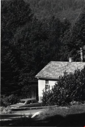
House at Sullivan and Willoughby
https://search.heritageburnaby.ca/link/archivedescription78886
- Repository
- City of Burnaby Archives
- Date
- October 23, 1976
- Collection/Fonds
- Burnaby Public Library Contemporary Visual Archive Project
- Description Level
- Item
- Physical Description
- 1 photograph : b&w ; 11 x 16 cm mounted on cardboard
- Scope and Content
- Photograph shows a house located at the corner of Sullivan Street and Willoughby Avenue.
- Repository
- City of Burnaby Archives
- Date
- October 23, 1976
- Collection/Fonds
- Burnaby Public Library Contemporary Visual Archive Project
- Physical Description
- 1 photograph : b&w ; 11 x 16 cm mounted on cardboard
- Description Level
- Item
- Record No.
- 556-013
- Access Restriction
- No restrictions
- Reproduction Restriction
- Reproduce for fair dealing purposes only
- Accession Number
- 2013-13
- Scope and Content
- Photograph shows a house located at the corner of Sullivan Street and Willoughby Avenue.
- Media Type
- Photograph
- Photographer
- Campbell, Peg
- Notes
- Scope note taken directly from BPL photograph description.
- 1 b&w copy negative : 10 x 12.5 cm accompanying
- Geographic Access
- Sullivan Street
- Willoughby Avenue
- Historic Neighbourhood
- Burquitlam (Historic Neighbourhood)
- Planning Study Area
- Lyndhurst Area
Images

House at 9839 East Broadway
https://search.heritageburnaby.ca/link/archivedescription78921
- Repository
- City of Burnaby Archives
- Date
- September 20, 1976
- Collection/Fonds
- Burnaby Public Library Contemporary Visual Archive Project
- Description Level
- Item
- Physical Description
- 1 photograph : b&w ; 11 x 16 cm mounted on cardboard
- Scope and Content
- Photograph shows a house and car at 9839 East Broadway, with Burnaby Mountain in the background.
- Repository
- City of Burnaby Archives
- Date
- September 20, 1976
- Collection/Fonds
- Burnaby Public Library Contemporary Visual Archive Project
- Physical Description
- 1 photograph : b&w ; 11 x 16 cm mounted on cardboard
- Description Level
- Item
- Record No.
- 556-035
- Access Restriction
- No restrictions
- Reproduction Restriction
- Reproduce for fair dealing purposes only
- Accession Number
- 2013-13
- Scope and Content
- Photograph shows a house and car at 9839 East Broadway, with Burnaby Mountain in the background.
- Media Type
- Photograph
- Photographer
- Campbell, Peg
- Notes
- Scope note taken directly from BPL photograph description.
- 1 b&w copy negative : 10 x 12.5 cm accompanying
- Geographic Access
- Broadway
- Street Address
- 9839 Broadway
- Historic Neighbourhood
- Burquitlam (Historic Neighbourhood)
- Planning Study Area
- Lyndhurst Area
Images

Quesnel Greene Construction
https://search.heritageburnaby.ca/link/archivedescription79014
- Repository
- City of Burnaby Archives
- Date
- October 23, 1976
- Collection/Fonds
- Burnaby Public Library Contemporary Visual Archive Project
- Description Level
- Item
- Physical Description
- 1 photograph : b&w ; 11 x 16 cm mounted on cardboard
- Scope and Content
- Photograph shows Quesnel Greene construction sign located at the corner of Aquarius Drive and Centaurus Circle. The Quesnel Green Co-operative Housing project was designed by Neinhaker/Irwin Associates and was built by Dunhill Development Corporation Ltd. It was owned by the Government of British…
- Repository
- City of Burnaby Archives
- Date
- October 23, 1976
- Collection/Fonds
- Burnaby Public Library Contemporary Visual Archive Project
- Physical Description
- 1 photograph : b&w ; 11 x 16 cm mounted on cardboard
- Description Level
- Item
- Record No.
- 556-091
- Access Restriction
- No restrictions
- Reproduction Restriction
- Reproduce for fair dealing purposes only
- Accession Number
- 2013-13
- Scope and Content
- Photograph shows Quesnel Greene construction sign located at the corner of Aquarius Drive and Centaurus Circle. The Quesnel Green Co-operative Housing project was designed by Neinhaker/Irwin Associates and was built by Dunhill Development Corporation Ltd. It was owned by the Government of British Columbia.
- Media Type
- Photograph
- Photographer
- Campbell, Peg
- Notes
- Scope note taken directly from BPL photograph description.
- 1 b&w copy negative : 10 x 12.5 cm accompanying
- Geographic Access
- Centaurus Circle
- Aquarius Drive
- Historic Neighbourhood
- Burquitlam (Historic Neighbourhood)
- Planning Study Area
- Lyndhurst Area
Images


Quesnel Greene Co-operative
https://search.heritageburnaby.ca/link/archivedescription79015
- Repository
- City of Burnaby Archives
- Date
- October 23, 1976
- Collection/Fonds
- Burnaby Public Library Contemporary Visual Archive Project
- Description Level
- Item
- Physical Description
- 1 photograph : b&w ; 11 x 16 cm mounted on cardboard
- Scope and Content
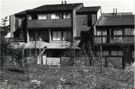
- Photograph shows Quesnel Greene co-operative housing units located near the corner of Centaurus Drive and Centaurus Circle.
- Repository
- City of Burnaby Archives
- Date
- October 23, 1976
- Collection/Fonds
- Burnaby Public Library Contemporary Visual Archive Project
- Physical Description
- 1 photograph : b&w ; 11 x 16 cm mounted on cardboard
- Description Level
- Item
- Record No.
- 556-092
- Access Restriction
- No restrictions
- Reproduction Restriction
- Reproduce for fair dealing purposes only
- Accession Number
- 2013-13
- Scope and Content
- Photograph shows Quesnel Greene co-operative housing units located near the corner of Centaurus Drive and Centaurus Circle.
- Media Type
- Photograph
- Photographer
- Campbell, Peg
- Notes
- Scope note taken directly from BPL photograph description.
- 1 b&w copy negative : 10 x 12.5 cm accompanying
- Geographic Access
- Centaurus Circle
- Centaurus Drive
- Historic Neighbourhood
- Burquitlam (Historic Neighbourhood)
- Planning Study Area
- Lyndhurst Area
Images

Townhouses on Centaurus Circle
https://search.heritageburnaby.ca/link/archivedescription79017
- Repository
- City of Burnaby Archives
- Date
- September 20, 1976
- Collection/Fonds
- Burnaby Public Library Contemporary Visual Archive Project
- Description Level
- Item
- Physical Description
- 1 photograph : b&w ; 11 x 16 cm mounted on cardboard
- Scope and Content
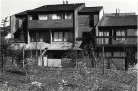
- Photograph shows townhouses located on Centaurus Circle.
- Repository
- City of Burnaby Archives
- Date
- September 20, 1976
- Collection/Fonds
- Burnaby Public Library Contemporary Visual Archive Project
- Physical Description
- 1 photograph : b&w ; 11 x 16 cm mounted on cardboard
- Description Level
- Item
- Record No.
- 556-093
- Access Restriction
- No restrictions
- Reproduction Restriction
- Reproduce for fair dealing purposes only
- Accession Number
- 2013-13
- Scope and Content
- Photograph shows townhouses located on Centaurus Circle.
- Media Type
- Photograph
- Photographer
- Campbell, Peg
- Notes
- Scope note taken directly from BPL photograph description.
- 1 b&w copy negative : 10 x 12.5 cm accompanying
- Geographic Access
- Centaurus Circle
- Historic Neighbourhood
- Burquitlam (Historic Neighbourhood)
- Planning Study Area
- Lyndhurst Area
Images
Columbian Newspaper Carriers
https://search.heritageburnaby.ca/link/archivedescription79459
- Repository
- City of Burnaby Archives
- Date
- October 23, 1976
- Collection/Fonds
- Burnaby Public Library Contemporary Visual Archive Project
- Description Level
- Item
- Physical Description
- 1 photograph : b&w ; 11 x 16 cm mounted on cardboard
- Scope and Content
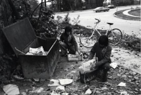
- Photograph shows Columbian Newspaper carriers picking up their papers on the corner of Beaverbrook Crescent and Beaverbrook Drive.
- Repository
- City of Burnaby Archives
- Date
- October 23, 1976
- Collection/Fonds
- Burnaby Public Library Contemporary Visual Archive Project
- Physical Description
- 1 photograph : b&w ; 11 x 16 cm mounted on cardboard
- Description Level
- Item
- Record No.
- 556-300
- Access Restriction
- No restrictions
- Reproduction Restriction
- Reproduce for fair dealing purposes only
- Accession Number
- 2013-13
- Scope and Content
- Photograph shows Columbian Newspaper carriers picking up their papers on the corner of Beaverbrook Crescent and Beaverbrook Drive.
- Media Type
- Photograph
- Photographer
- Campbell, Peg
- Notes
- Scope note taken directly from BPL photograph description.
- 1 b&w copy negative : 10 x 12.5 cm accompanying
- Geographic Access
- Beaverbrook Crescent
- Beaverbrook Drive
- Historic Neighbourhood
- Burquitlam (Historic Neighbourhood)
- Planning Study Area
- Lyndhurst Area
Images

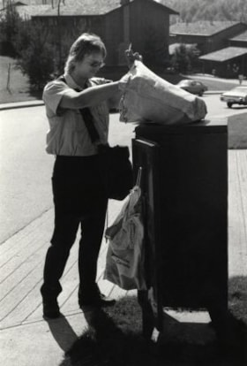
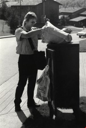
Postman
https://search.heritageburnaby.ca/link/archivedescription79471
- Repository
- City of Burnaby Archives
- Date
- September 20, 1976
- Collection/Fonds
- Burnaby Public Library Contemporary Visual Archive Project
- Description Level
- Item
- Physical Description
- 1 photograph : b&w ; 11 x 16 cm mounted on cardboard
- Scope and Content
- Photograph shows a postman gathering and sorting the mail at his route distribution box on Centaurus Drive.
- Repository
- City of Burnaby Archives
- Date
- September 20, 1976
- Collection/Fonds
- Burnaby Public Library Contemporary Visual Archive Project
- Physical Description
- 1 photograph : b&w ; 11 x 16 cm mounted on cardboard
- Description Level
- Item
- Record No.
- 556-303
- Access Restriction
- No restrictions
- Reproduction Restriction
- Reproduce for fair dealing purposes only
- Accession Number
- 2013-13
- Scope and Content
- Photograph shows a postman gathering and sorting the mail at his route distribution box on Centaurus Drive.
- Media Type
- Photograph
- Photographer
- Campbell, Peg
- Notes
- Scope note taken directly from BPL photograph description.
- 1 b&w copy negative : 10 x 12.5 cm accompanying
- Geographic Access
- Centaurus Drive
- Historic Neighbourhood
- Burquitlam (Historic Neighbourhood)
- Planning Study Area
- Lyndhurst Area
Images
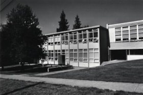
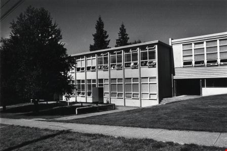
Lyndhurst Elementary School
https://search.heritageburnaby.ca/link/archivedescription79614
- Repository
- City of Burnaby Archives
- Date
- September 20, 1976
- Collection/Fonds
- Burnaby Public Library Contemporary Visual Archive Project
- Description Level
- Item
- Physical Description
- 1 photograph : b&w ; 11 x 16 cm mounted on cardboard
- Scope and Content
- Photograph shows Lyndhurst Elementary School at 9847 Lyndhurst Street.
- Repository
- City of Burnaby Archives
- Date
- September 20, 1976
- Collection/Fonds
- Burnaby Public Library Contemporary Visual Archive Project
- Physical Description
- 1 photograph : b&w ; 11 x 16 cm mounted on cardboard
- Description Level
- Item
- Record No.
- 556-355
- Access Restriction
- No restrictions
- Reproduction Restriction
- Reproduce for fair dealing purposes only
- Accession Number
- 2013-13
- Scope and Content
- Photograph shows Lyndhurst Elementary School at 9847 Lyndhurst Street.
- Subjects
- Buildings - Schools
- Media Type
- Photograph
- Photographer
- Campbell, Peg
- Notes
- Scope note taken directly from BPL photograph description.
- 1 b&w copy negative : 10 x 12.5 cm accompanying
- Geographic Access
- Lyndhurst Street
- Street Address
- 9847 Lyndhurst Street
- Historic Neighbourhood
- Burquitlam (Historic Neighbourhood)
- Planning Study Area
- Lyndhurst Area
Images