Narrow Results By
Subject
- Agriculture 1
- Agriculture - Farms 2
- Agriculture - Ranches 1
- Animals - Pigs 1
- Building Components 1
- Buildings - Agricultural 3
- Buildings - Agricultural - Greenhouses 2
- Buildings - Agricultural - Stables 1
- Buildings - Heritage 6
- Buildings - Residential 1
- Buildings - Residential - Cottages 1
- Buildings - Residential - Houses 1
Creator
- Albert F. Arnold McCarter & Nairne 1
- Burnaby Village Museum 1
- City of Burnaby 3
- Debbie Liang 1
- Frank William Macey 1
- Fred Laughton Townley 1
- George Selkirk Gibson 1
- James Charles Allen 1
- Liang, Debbie 1
- McCarter & Nairne 1
- Robert Mackay Fripp 6
- UBC Initiative for Student Teaching and Research in Chinese Canadian Studies 1

H.T. Ceperley Estate 'Fairacres' Steam Plant Building
https://search.heritageburnaby.ca/link/landmark528
- Repository
- Burnaby Heritage Planning
- Description
- Designed in the British Arts and Crafts style, the ‘Fairacres’ Steam Plant Buiding is a single-storey wood frame building with a gabled roof that originally housed the apparatus for climate control in the greenhouses, formerly located to its north. The original rubble stone walls that formed the fo…
- Associated Dates
- 1908
- Formal Recognition
- Heritage Designation, Community Heritage Register
- Repository
- Burnaby Heritage Planning
- Geographic Access
- Deer Lake Avenue
- Associated Dates
- 1908
- Formal Recognition
- Heritage Designation, Community Heritage Register
- Enactment Type
- Bylaw No. 9807
- Enactment Date
- 23/11/1992
- Description
- Designed in the British Arts and Crafts style, the ‘Fairacres’ Steam Plant Buiding is a single-storey wood frame building with a gabled roof that originally housed the apparatus for climate control in the greenhouses, formerly located to its north. The original rubble stone walls that formed the foundation for the greenhouses stand adjacent. The Steam Plant Building stands as a pendant to the Root House, which is to the north of the former greenhouses.
- Heritage Value
- The outbuildings at 'Fairacres' are a rare surviving architecturally-designed ensemble of agricultural structures that exist in complementary harmony with the main estate house. Architect Robert Mackay Fripp (1858-1917), an outspoken advocate of Arts and Crafts design, was retained by the Ceperleys to design several original outbuildings on their estate. The Ceperleys operated 'Fairacres' with staff, a farm manager and workers, including Chinese, to grow produce for themselves and for sale at local markets. The Steam Plant Building illustrates the market gardening activity of the area around Deer Lake and its importance to the Ceperley family, which valued a year-round supply of fresh fruit and vegetables for the kitchen and flowers for the house. It also illustrates the cultural and aesthetic values of the Ceperleys in retaining an architect to design a functional outbuilding using an accepted and contemporary architectural style. Built in 1908, the Steam Plant Building was significantly altered in the 1960s and restored to its original design in 2000.
- Defining Elements
- Key elements that define the heritage character of the ‘Fairacres’ Steam Plant Building include its: - overall spatial arrangement of the Steam Plant Building in relation to the former greenhouses and the Root House - side gable roof with cedar shingle cladding. - tall brick chimney indicitive of the building's original function. - distinctive Arts and Crafts architectural features such as the shingle wall cladding with decorative shingling under window sills, deep eaves, and pebble-dashed concrete foundation walls - six-paned wooden-sash casement windows - simple functional interior features - rubble stone walls that formed the foundation for the greenhouses
- Locality
- Deer Lake Park
- Historic Neighbourhood
- Burnaby Lake (Historic Neighbourhood)
- Planning Study Area
- Douglas-Gilpin Area
- Architect
- Robert Mackay Fripp
- Function
- Primary Historic--Outbuilding
- Community
- Burnaby
- Cadastral Identifier
- P.I.D. No. 004-493-311 Legal Description: Block 3 Except: Part subdivided by Plan 26865, District Lot 79, Group 1, New Westminster District, Plan 536
- Boundaries
- ‘Fairacres’ is comprised of a single municipally-owned property located at 6344 Deer Lake Avenue, Burnaby.
- Area
- 17,065.00
- Contributing Resource
- Building
- Landscape Feature
- Ownership
- Public (local)
- Other Collection
- Burnaby Historical Society, Community Archives: Ceperley Photograph Album
- Documentation
- Heritage Site Files: PC77000 20. City of Burnaby Planning and Building Department, 4949 Canada Way, Burnaby, B.C., V5G 1M2
- Street Address
- 6344 Deer Lake Avenue
Images


R.F. Anderson House
https://search.heritageburnaby.ca/link/landmark531
- Repository
- Burnaby Heritage Planning
- Description
- The R.F. Anderson House is a large, two-and-one-half storey Arts and Crafts style wood frame house, now located in Deer Lake Park, built as a family home and now used as institutional offices.
- Associated Dates
- 1912
- Formal Recognition
- Heritage Designation, Community Heritage Register
- Other Names
- Robert Fenwick & Bessie Anderson House, Anderson Residence
- Street View URL
- Google Maps Street View
- Repository
- Burnaby Heritage Planning
- Other Names
- Robert Fenwick & Bessie Anderson House, Anderson Residence
- Geographic Access
- Deer Lake Avenue
- Associated Dates
- 1912
- Formal Recognition
- Heritage Designation, Community Heritage Register
- Enactment Type
- Bylaw No. 9807
- Enactment Date
- 23/11/1992
- Description
- The R.F. Anderson House is a large, two-and-one-half storey Arts and Crafts style wood frame house, now located in Deer Lake Park, built as a family home and now used as institutional offices.
- Heritage Value
- The R.F. Anderson House contributes to the overall stylistic ambiance of the area and demonstrates that a range of architectural features can be read as a cohesive whole. Although designed primarily in the British Arts and Crafts genre, as were other residences around Deer Lake, it also displays some influences of the popular Craftsman style. It was constructed in the Deer Lake Crescent subdivision, which was originally promoted as an upper class neighbourhood. It represents one of the first residential developments in the City of Burnaby that required buildings to be of a specific value, thus demonstrating the desire for exclusivity among the successful businessmen who chose to settle in the area. The house and grounds illustrate the social, cultural, lifestyle and leisure sensibilities of a successful local businessman and his family in the early twentieth century; Anderson was a New Westminster hardware merchant and Justice of the Peace. The development of the house and grounds within a controlled suburban context also illustrate the values of the owners in the Deer Lake Crescent subdivision, such as social aspiration, racial exclusivity, demonstration of architectural taste, importance of a landscaped garden, and the provision of facilities for fashionable leisure pursuits such as lawn tennis. The estate makes an important contribution to the residential grouping now preserved within Deer Lake Park, and demonstrates the broad social mix of those who chose to live in the area at a time when it was in transition from a market gardening area to a more exclusive residential community. The R.F. Anderson House is important for its association with local architect Frank William Macey (1863-1935), the first resident architect in Burnaby. Macey was born and trained in England where he was well-respected for having published two standard texts for the architectural profession. He settled in Burnaby in the first decade of the twentieth century and obtained a number of commissions from prominent businessmen who were building grand homes in the new community of Deer Lake. He designed these houses mostly in the British Arts and Crafts style.
- Defining Elements
- Key elements that define the heritage character of the R.F. Anderson House include its: - location within a park setting in relation to the W.J. Mathers House - irregular massing of the exterior and its cladding of drop-siding, with half-timbering and rough-cast stucco in the gables - picturesque irregular roofline, including an alteration in pitch over the front verandah, with cedar shingle cladding - interior plan with its generous entrance hall, staircase, and massive staircase window with leaded-lights - multiple-assembly wooden-sash casement windows - quality of interior features such as the Douglas Fir woodwork (some with original varnish finish); original hardware supplied by Anderson's hardware company; and original fireplaces with ornate tile surrounds - setting with the imprint of the lawn tennis court, now a garden terrace, and some of the original plantings
- Locality
- Deer Lake Park
- Historic Neighbourhood
- Burnaby Lake (Historic Neighbourhood)
- Planning Study Area
- Douglas-Gilpin Area
- Architect
- Frank William Macey
- Function
- Primary Current--Government Office
- Primary Historic--Single Dwelling
- Community
- Burnaby
- Cadastral Identifier
- P.I.D. No. 007-525-931 Legal Description: North 225 feet Lot 'C', District Lot 79, Group 1, New Westminster District, Plan 6884
- Boundaries
- The R.F. Anderson House is comprised of a single municipally-owned property located at 6450 Deer Lake Avenue, Burnaby.
- Area
- 63,100.00
- Contributing Resource
- Building
- Landscape Feature
- Ownership
- Public (local)
- Documentation
- Heritage Site Files: PC77000 20. City of Burnaby Planning and Building Department, 4949 Canada Way, Burnaby, B.C., V5G 1M2
- Names
- Macey, Frank W.
- Street Address
- 6450 Deer Lake Avenue
- Street View URL
- Google Maps Street View
Images


Shadbolt Centre for the Arts
https://search.heritageburnaby.ca/link/landmark820
- Repository
- Burnaby Heritage Planning
- Geographic Access
- Deer Lake Avenue
- Associated Dates
- 1995
- Heritage Value
- The Shadbolt Centre for the Arts opened in 1995. The Shadbolt Centre was named after two Burnaby residents who dedicated a lifetime of support and cultivation of the arts locally, nationally and internationally. Doris and Jack Shadbolt resided in Burnaby for over 50 years until Jack's death in November 1998. Doris Shadbolt spent her life's work bringing the artist and the audience closer together through her writing and curatorial work. Jack Shadbolt was an internationally recognized Canadian painter. He was also an author and both received many awards including the Order of Canada. In keeping with the Shadbolts' generosity the arts, Jack Shadbolt donated two of his paintings to the Centre for permanent display.
- Historic Neighbourhood
- Burnaby Lake (Historic Neighbourhood)
- Planning Study Area
- Douglas-Gilpin Area
- Street Address
- 6450 Deer Lake Avenue
- Street View URL
- Google Maps Street View
Images


T.O. Townley Estate 'Deerholme'
https://search.heritageburnaby.ca/link/landmark545
- Repository
- Burnaby Heritage Planning
- Description
- The T.O. Townley Estate, 'Deerholme,' is located on a lake front property on the north shore of Deer Lake Park. The main house is a two-and-one-half storey symmetrical-massed wood-frame Colonial Revival structure, with flanking one-storey wings, a side gable roof and a central front entry.
- Associated Dates
- 1913
- Formal Recognition
- Heritage Designation, Community Heritage Register
- Other Names
- Thomas & Frances Townley Estate, Loftus House
- Street View URL
- Google Maps Street View
- Repository
- Burnaby Heritage Planning
- Other Names
- Thomas & Frances Townley Estate, Loftus House
- Geographic Access
- Price Street
- Associated Dates
- 1913
- Formal Recognition
- Heritage Designation, Community Heritage Register
- Enactment Type
- Bylaw No. 9807
- Enactment Date
- 23/11/1992
- Description
- The T.O. Townley Estate, 'Deerholme,' is located on a lake front property on the north shore of Deer Lake Park. The main house is a two-and-one-half storey symmetrical-massed wood-frame Colonial Revival structure, with flanking one-storey wings, a side gable roof and a central front entry.
- Heritage Value
- 'Deerholme' was built as the retirement estate of Lieutenant-Colonel Thomas Owen Townley (1862-1935) and his wife, Frances M. Townley. Townley was a pioneer resident of the Lower Mainland of British Columbia: he served as a lawyer, Registrar of Land Titles for New Westminster District and Mayor of Vancouver for one term in 1901. Built in 1913, this is one of the most significant of the Deer Lake estate houses and was the last of grand Edwardian era mansions built on the lots surrounding the lake. The area had been opened up for development two years earlier by the construction of the British Columbia Electric Railway Interurban Line. The estate speaks of a gracious way of life achieved by society's elite during the Edwardian era, supported by the use of domestic servants. Grand in scale, architecturally sophisticated and set in a bucolic landscape, this residence demonstrates the social status of the owner in the privileged classes of the rapidly developing social structure of Burnaby. The house is also significant as one of the earliest designs by the son of Thomas and Frances Townley, architect Fred Laughton Townley (1887-1966), who had graduated in architecture in 1911 from the University of Pennsylvania. In this house for his parents, he demonstrated his deft understanding of the American Period Revival styles learned during his schooling in the United States. The prevailing local taste for British-derived architecture dictated that this was a style he was rarely able to use until the Colonial Revival styles became more popular in the 1920s. F.L. Townley was a founding partner in Townley and Matheson, which achieved significant success as one of the most accomplished local architectural firms, culminating in their best-known commission, Vancouver City Hall, 1935-36.
- Defining Elements
- Key elements the define the heritage character of ‘Deerholme’ include its: - integration with its south-sloping lakefront site, which contains many original landscape features (extant rockeries, formal drive, tennis lawn, open fields, and specimen shrubs and trees) - two-and-one-half storey form with flanking one-storey wings - side gable roof with symmetrical shed dormers, three at the front and three at the rear - complex fenestration, including multi-paned wooden-sash double-hung windows, 6-over-1 on the ground floor and 6-over-9 on the second floor, and multi-paned wooden-sash casements in the dormers - pair of prominent exterior brick chimneys on each side elevation, clad with rough-cast stucco up to the roof level, and each with four chimney-pots - rough-cast stucco cladding - design elements typical of the Colonial Revival style, such as composed classical formality, side gable roof and balanced symmetrical massing - exterior architectural elements, such as classical columns, window shutters, fanlight feature window, multi-paned quarter-round windows flanking the chimneys, and projecting square brackets in the gables - superior level of design and craftsmanship throughout, including refined interior woodwork such as fireplaces, interior columned screen between hallway and living room and a staircase with Colonial Revival details - significant mature trees (such as Red Oaks, Silver Maples, and Copper Beech). - original guest house and stables, which survive on an adjacent property at 6176 Price Street
- Historic Neighbourhood
- Burnaby Lake (Historic Neighbourhood)
- Planning Study Area
- Douglas-Gilpin Area
- Architect
- Fred Laughton Townley
- Function
- Primary Current--Estate
- Primary Historic--Estate
- Community
- Burnaby
- Cadastral Identifier
- P.I.D. No. 002-652-111 Legal Description: Parcel 'C' (Explanatory Plan 12891) , Blocks 4 and 5, District Lot 79 Group 1, New Westminster District, Plan 536
- Boundaries
- ‘Deerholme’ is comprised of a single municipally-owned property located at 6110 Price Street, Burnaby.
- Area
- 14,099.52
- Contributing Resource
- Building
- Landscape Feature
- Ownership
- Public (local)
- Other Collection
- City of Vancouver Archives: T.O. Townley Residence, Original Plans, Add. MSS. 1399, Temporary No. 61, Location 920-D
- Documentation
- Heritage Site Files: PC77000 20. City of Burnaby Planning and Building Department, 4949 Canada Way, Burnaby, B.C., V5G 1M2
- Street Address
- 6110 Price Street
- Street View URL
- Google Maps Street View
Images


William & Edith Blott Residence
https://search.heritageburnaby.ca/link/landmark655
- Repository
- Burnaby Heritage Planning
- Description
- Residential building.
- Associated Dates
- 1923
- Street View URL
- Google Maps Street View
- Repository
- Burnaby Heritage Planning
- Geographic Access
- Laurel Street
- Associated Dates
- 1923
- Description
- Residential building.
- Heritage Value
- This elegant house is a prominent local landmark, with a bellcast hipped roof, deep bracketed eaves and Doric porch columns. The use of the various Colonial Revival styles had gained new popularity during the 1920s at the time of the American Sesquicentennial, as is evident in the symmetrical façade composition and detailing. It was the home of William Alexander Blott (1878-1962), a shipper at the Broder Canning Company and later a real estate agent, and his wife Edith Carruthers Blott (née Shaw, 1890-1972), who were married in 1913. It is one of the few remaining larger estate homes along the formerly rural Douglas Road.
- Locality
- Burnaby Lake
- Historic Neighbourhood
- Burnaby Lake (Historic Neighbourhood)
- Planning Study Area
- Douglas-Gilpin Area
- Area
- 1023.73
- Contributing Resource
- Building
- Ownership
- Private
- Street Address
- 5558 Laurel Street
- Street View URL
- Google Maps Street View
Images


W.J. Mathers House 'Altnadene'
https://search.heritageburnaby.ca/link/landmark532
- Repository
- Burnaby Heritage Planning
- Description
- The W.J. Mathers House 'Altnadene', is a two-and-one-half storey wood frame house set in a large terraced garden, now located in Deer Lake Park. Built as a family home, it is designed in the British Arts and Crafts style enriched by Tudor, Romanesque, and medieval details.
- Associated Dates
- 1912
- Formal Recognition
- Heritage Designation, Community Heritage Register
- Other Names
- William & Mary Mathers Residence
- Street View URL
- Google Maps Street View
- Repository
- Burnaby Heritage Planning
- Other Names
- William & Mary Mathers Residence
- Geographic Access
- Deer Lake Avenue
- Associated Dates
- 1912
- Formal Recognition
- Heritage Designation, Community Heritage Register
- Enactment Type
- Bylaw No. 9807
- Enactment Date
- 23/11/1992
- Description
- The W.J. Mathers House 'Altnadene', is a two-and-one-half storey wood frame house set in a large terraced garden, now located in Deer Lake Park. Built as a family home, it is designed in the British Arts and Crafts style enriched by Tudor, Romanesque, and medieval details.
- Heritage Value
- 'Altnadene' was constructed in the Deer Lake Crescent subdivision, which was originally promoted as an upper class neighbourhood. It represents one of the first residential developments in the City of Burnaby that required buildings to be of a specific value, thus demonstrating the desire for exclusivity among the successful businessmen who chose to settle in the area. The house and grounds illustrate the social, cultural, lifestyle and leisure sensibilities of the owners in the Deer Lake Crescent subdivision: such values as social aspiration, racial exclusivity, demonstration of architectural taste, importance of a landscaped garden, and the provision of facilities for fashionable pursuits such as lawn tennis. The estate is historically significant for its connection to William John Mathers (1859-1929), an early pioneer who arrived in New Westminster in 1876, an enterprising grain dealer, businessman, alderman, president of the Board of Trade and various other local organizations, and a 'public spirited and progressive citizen.' Designed for Mathers and his wife, Mary Elizabeth Jane (Whelan) Mathers (1869-1939), by Burnaby architect Frank William Macey (1863-1935), the Arts and Crafts style of the Mathers House contributes to the overall stylistic ambiance of the collection of homes now preserved in Deer Lake Park, displaying an eclectic array of details that give it a unique identity. The first resident architect in Burnaby, Macey was born and trained in England where he was well-respected for having published two standard texts for the architectural profession. He settled in Burnaby in the first decade of the twentieth century and obtained a number of commissions from prominent businessmen who were building grand homes in the new community of Deer Lake. He designed mostly in the British Arts and Crafts style and introduced the use of rough-cast stucco for building exteriors, a characteristic for which he was renowned. The house also has an important connection to Burnaby’s history as it later served as a convalescent home for soldiers wounded on the battlefront during the First World War. Indicative of the evolving functionality of the site, a classroom wing was added in 1939 after Benedictine Monks acquired the house and it was operated as the Seminary of Christ the King.
- Defining Elements
- Key elements that define the heritage character of 'Altnadene' include its: - prominent corner location within a park setting, in relation to the Anderson residence - irregular form and massing - irregular roof line, including a central pyramidal hipped section and open gable ends to front and sides, with cedar shingle cladding - exterior of rough-cast stucco and half-timbering - eclectic exterior details such as the Tudor arches of the verandah; and the medieval crenellations of the tower - mixture of double-hung and casement, with transom, wooden-sash windows - massive chimneys of Clayburn firebrick - surviving interior details such as fireplaces, doors and leaded glass - wrought iron gates, massive gate-posts inscribed with 'Altnadene' and granite walls at the corner entry of the property
- Locality
- Deer Lake Park
- Historic Neighbourhood
- Burnaby Lake (Historic Neighbourhood)
- Planning Study Area
- Douglas-Gilpin Area
- Function
- Primary Current--Recreation Centre
- Primary Historic--Estate
- Community
- Burnaby
- Cadastral Identifier
- P.I.D. No. 007-527-241 Legal Description: Lot 'B', District Lot 79, Group 1, New Westminster District, Plan 6642
- Boundaries
- 'Altnadene' is comprised of a single municipally-owned property located at 6490 Deer Lake Avenue, Burnaby.
- Area
- 17,065.00
- Contributing Resource
- Building
- Landscape Feature
- Ownership
- Public (local)
- Other Collection
- City of Burnaby: Salvaged original elements from the house, including fireplace surrounds, doors and hardware
- Street Address
- 6490 Deer Lake Avenue
- Street View URL
- Google Maps Street View
Images


W.J. Mathers House 'Altnadene' Gate & Wall
https://search.heritageburnaby.ca/link/landmark858
- Repository
- Burnaby Heritage Planning
- Description
- The gate and wall of the W.J. Mathers House 'Altnadene' form an integral part of the heritage character of this historic estate, which includes a two-and-one-half storey wood frame house set in a large terraced garden, now located in Deer Lake Park. Built as a family home, it is designed in the Bri…
- Associated Dates
- 1912
- Formal Recognition
- Heritage Designation, Community Heritage Register
- Other Names
- William & Mary Mathers Residence
- Street View URL
- Google Maps Street View
- Repository
- Burnaby Heritage Planning
- Other Names
- William & Mary Mathers Residence
- Geographic Access
- Deer Lake Avenue
- Associated Dates
- 1912
- Formal Recognition
- Heritage Designation, Community Heritage Register
- Enactment Type
- Bylaw No. 13196
- Enactment Date
- 13/05/2013
- Description
- The gate and wall of the W.J. Mathers House 'Altnadene' form an integral part of the heritage character of this historic estate, which includes a two-and-one-half storey wood frame house set in a large terraced garden, now located in Deer Lake Park. Built as a family home, it is designed in the British Arts and Crafts style enriched by Tudor, Romanesque, and medieval details.
- Heritage Value
- 'Altnadene' was constructed in the Deer Lake Crescent subdivision, which was originally promoted as an upper class neighbourhood. It represents one of the first residential developments in the City of Burnaby that required buildings to be of a specific value, thus demonstrating the desire for exclusivity among the successful businessmen who chose to settle in the area. The house and grounds illustrate the social, cultural, lifestyle and leisure sensibilities of the owners in the Deer Lake Crescent subdivision: such values as social aspiration, racial exclusivity, demonstration of architectural taste, importance of a landscaped garden, and the provision of facilities for fashionable pursuits such as lawn tennis. The estate is historically significant for its connection to William John Mathers (1859-1929), an early pioneer who arrived in New Westminster in 1876, an enterprising grain dealer, businessman, alderman, president of the Board of Trade and various other local organizations, and a 'public spirited and progressive citizen.' The landscape of the estate featured a landmark granite capstone wall and wrought iron gate surrounding the front garden and terraced lawns of the mansion. The overall architectural intention was to reference medieval English estates by surrounding the ‘castle’ with a stone wall with gated entrances. The stone material for the construction of the wall was quarried from large ‘glacial erratic’ granite boulders found on the property. The highly decorative wrought iron gate was designed and made by artisan James A. Blair, a Scottish blacksmith employed by the Westminster Iron Works in 1912. The design for the 'double' driveway gate was featured in the company’s original catalogue as 'Design No. 152'. These gates are a very unusual and rare example of their type and are some of the most elaborate surviving examples in the City.
- Defining Elements
- Key elements that define the heritage character of the gate and wall at 'Altnadene' include its: - wrought iron gates, massive gate-posts inscribed with 'Altnadene' and granite walls at the corner entry of the property
- Locality
- Deer Lake Park
- Historic Neighbourhood
- Burnaby Lake (Historic Neighbourhood)
- Planning Study Area
- Douglas-Gilpin Area
- Organization
- Westminster Iron Works
- Function
- Primary Current--Recreation Centre
- Primary Historic--Estate
- Community
- Burnaby
- Cadastral Identifier
- P.I.D. No. 007-527-241 Legal Description: Lot 'B', District Lot 79, Group 1, New Westminster District, Plan 6642
- Boundaries
- 'Altnadene' is comprised of a single municipally-owned property located at 6490 Deer Lake Avenue, Burnaby.
- Area
- 17,065.00
- Contributing Resource
- Landscape Feature
- Ownership
- Public (local)
- Street Address
- 6490 Deer Lake Avenue
- Street View URL
- Google Maps Street View
Images


A Pig's Tale
https://search.heritageburnaby.ca/link/museumdescription14365
- Repository
- Burnaby Village Museum
- Date
- Oct. 2020
- Collection/Fonds
- Burnaby Village Museum fonds
- Description Level
- Item
- Physical Description
- 3 video recordings (mp4) (5 min., 28 sec.) : digital, col., sd., stereo, subtitles
- Scope and Content
- Item consists of part two in a two part video series "A Taste of History" created by Debbie Liang and Joty Gill, University of British Columbia alumni and graduates from the Asian Canadian & Asian Migration Studies program (ACAM). Part two is titled "A Pig's Tale". The film highlights the history o…
- Repository
- Burnaby Village Museum
- Collection/Fonds
- Burnaby Village Museum fonds
- Series
- UBC Partnership series
- Description Level
- Item
- Physical Description
- 3 video recordings (mp4) (5 min., 28 sec.) : digital, col., sd., stereo, subtitles
- Material Details
- Script: Debbie Liang; Joty Gill Narration: Joty Gill Editor: Debbie Liang Subtitles: English; Simplified Chinese; Traditional Chinese Video Appearances: Kathy Lee; Eleanor Lee Illustrations and Animations: Debbie Liang Photos, Images & B-roll: Piggery photo, image courtesy of Elwin Xie; Douglas Road: City of Burnaby Archives, 477-841; Canada Way, City of Burnaby Archives, 556-522, photo by Peg Campbell; Red pig by Debbie Liang; Piglets sleeping, image courtesy of RoyBuri from pixabay, free to use; Chinese Zodiac, image courtesy of RoofOfAllLight from wikimedia, Creative Commons Attribution-Share Alike 4.0 International license; Pictograph for Home by Debbie Liang; Pigs lying down, image courtesy of Elwin Xie; Council minutes all from heritageburnaby.com; Cleanliness illustration set by Debbie Liang; "The Heathen Chinese in British Columbia" from Library and Archives Canada; Laundryman spitting from Daily News, Prince Rupert in 1911; Slicer on counter at Way Sang Yuen Wat Kee & Co., Burnaby Village Museum BV017.7.290; Way Sang Yuen Wat Kee & Co. Store front, Burnaby Village Museum BV017.7.191; Medical Practices Disagreement illustration by Debbie Liang; Butchering pig, image courtesy of Elwin Xie; Chinatown brolls, courtesy of Food2 group from UBC's 2019 ACAM 390 Class; Black Rotary telephone beside ball pen on white printed paper, image courtesy of Pixabay from pexels.com, free to use; Burnaby Lake on a cloudy day, image courtesy of Flying Pegunin from wikipedia; The Vancouver Sun May 4, 1921 from newspapers.com; Vancouver Daily May 3, 1921 from newspapers.com; Reduce number of pigs illustration by Debbie Liang; Black and white photo of piggery, image courtesy of Elwin Xie; 2019 Piggery illustration by Debbie Liang Music and Sound Effects: "Acoustic Mediation 2" from audionautix; Pig Grunting sounds from Kiddopedia Animasl, Creative Commons 0; "Piano moment" & "November" from bensound.com; "Ding sound effect" from freesoundlibrary; Wuxia2_Guzheng_Pipa by PeriTune http://peritune.com; Music promoted by https://www.free-stock-music.com; Attribution 4.0 International (CC BY 4.0) https://creativecommons.org/licenses/by/4.0/ Video adapted from 2019 BVM intern project by Debbie Liang and Marcela Gomez Special thanks to: UBC: Joanna Yang, Jenny Lu, Denise Fong, Henry Yu; BVM: Kate Petrusa, Amy Wilson Changes to music may have been made for the purposes of this video
- Scope and Content
- Item consists of part two in a two part video series "A Taste of History" created by Debbie Liang and Joty Gill, University of British Columbia alumni and graduates from the Asian Canadian & Asian Migration Studies program (ACAM). Part two is titled "A Pig's Tale". The film highlights the history of Chinese pig farms also known as "Piggeries" in Burnaby. The film tells the story of how many of these farms were established by Chinese immigrants along Douglas Road (now Canada Way) between the 1890s and 1920s; the importance of the pig in the Chinese Culture as well as a way for Chinese immigrants to make a living and the racism and discriminatory bylaws that the Chinese pig farmers suffered that finally led to the closure of many of these farms. Content references three documented piggery ranches along Douglas Road: Ah Sam; Young Chung and Hop Hin Yen. The films are supported with voice over in english, subtitles, animation along with historical photographs. One version of the film is supported with subtitles in English while two other versions of the film are supported with subtitles in Simplified Chinese and Traditional Chinese.
- History
- In 2020, due to the restrictions of COVID-19, University of British Columbia student interns with the Burnaby Village Museum Chinese Canadian History in Burnaby project were asked to create virtual experiences to reimagine Burnaby Village Museum's historical Chinese Canadian programming in remote online spaces. Debbie Liang and Joty Gill (UBC alumni and graduates of Dr. Henry Yu's 2019 summer ACAM 390A Global Seminar to Aisa) returned to work with Burnaby Village Museum to create two short films showcasing the history of Chinese Canadian Chop Suey restaurants and piggeries in Burnaby.
- Creator
- Liang, Debbie
- Debbie Liang
- Subjects
- Persons - Chinese Canadians
- Social Issues - Discrimination
- Social Issues - Racism
- Regulations
- Agriculture
- Agriculture - Farms
- Agriculture - Ranches
- Animals - Pigs
- Names
- Liang, Debbie
- Gill, Joty
- Burnaby Village Museum
- University of British Columbia
- Xie, Elwin
- Way Sang Yuen Wat Kee & Company
- Ah Sam
- Young Chung
- Hop Hin Yen
- Responsibility
- University of British Columbia
- UBC Initiative for Student Teaching and Research in Chinese Canadian Studies
- Burnaby Village Museum
- Geographic Access
- Douglas Road
- Canada Way
- Accession Code
- BV020.28.7
- Access Restriction
- No restrictions
- Reproduction Restriction
- No known restrictions
- Date
- Oct. 2020
- Media Type
- Moving Images
- Historic Neighbourhood
- Burnaby Lake (Historic Neighbourhood)
- Planning Study Area
- Douglas-Gilpin Area
- Notes
- Transcribed title
Images


Video
A Pig's Tale, Oct. 2020
A Pig's Tale, Oct. 2020
https://search.heritageburnaby.ca/media/hpo/_Data/_BVM_Moving_Images/2020_0028_0007_001.mp4
Film of Julie Lee discussing her family farm in the Big Bend area
https://search.heritageburnaby.ca/link/museumdescription4378
- Repository
- Burnaby Village Museum
- Date
- 6 Oct 2017
- Collection/Fonds
- Burnaby Village Museum fonds
- Description Level
- Item
- Physical Description
- 1 m4v video (13 min., 59 sec.) : digital, 23 fps, col., sd., stereo
- Scope and Content
- Film of Julie Lee discussing her family farm in the Big Bend area of Burnaby during a presentation as part of the "Chinese Canadian Stories" Lecture. This lecture was part of the Burnaby Neighbourhood History Series on October 4, 2017 at the Metrotown branch of the Burnaby Public Library. Julie Lee…
- Repository
- Burnaby Village Museum
- Collection/Fonds
- Burnaby Village Museum fonds
- Description Level
- Item
- Physical Description
- 1 m4v video (13 min., 59 sec.) : digital, 23 fps, col., sd., stereo
- Scope and Content
- Film of Julie Lee discussing her family farm in the Big Bend area of Burnaby during a presentation as part of the "Chinese Canadian Stories" Lecture. This lecture was part of the Burnaby Neighbourhood History Series on October 4, 2017 at the Metrotown branch of the Burnaby Public Library. Julie Lee discusses what life was like growing up on her family farm in the Douglas-Gilpin area, at the corner of Still Creek and Douglas Road in Burnaby.
- History
- Julie Lee is the daughter of Suey Ying Jung (Laura) and Puy Yuen Chan. The couple were married at Fraser Mills in October, 1942. The family owned a farm on Douglas Road near Still Creek in the early 1900s. Their farm was located in front of the Douglas Road interurban tram station.
- Subjects
- Agriculture - Farms
- Accession Code
- BV018.6.1
- Reproduction Restriction
- No known restrictions
- Date
- 6 Oct 2017
- Media Type
- Moving Images
- Historic Neighbourhood
- Burnaby Lake (Historic Neighbourhood)
- Planning Study Area
- Douglas-Gilpin Area
- Notes
- Title based on contents of film
Images

Video
Film of Julie Lee discussing her family farm in the Big Bend area, 6 Oct 2017
Film of Julie Lee discussing her family farm in the Big Bend area, 6 Oct 2017
https://search.heritageburnaby.ca/media/hpo/_Data/_BVM_Moving_Images/2018_0006_0001_001.m4v
Mayor's address re COVID-19
https://search.heritageburnaby.ca/link/museumdescription15398
- Repository
- Burnaby Village Museum
- Date
- 23 Mar. 2020
- Collection/Fonds
- Burnaby Village Museum COVID-19 collection
- Description Level
- Item
- Physical Description
- 1 video recording (mp4) (3 min., 14 sec.) : digital, 24 fps, col., sd., stereo
- Scope and Content
- Film clip of Burnaby Mayor Mike Hurley delivering an online address to the citizens of Burnaby. The Mayor is seated at his desk at Burnaby City Hall. The Mayor provides his comments and concerns regarding the impact the COVID-19 pandemic is having on the City of Burnaby and it's citizens. He speaks…
- Repository
- Burnaby Village Museum
- Collection/Fonds
- Burnaby Village Museum COVID-19 collection
- Description Level
- Item
- Physical Description
- 1 video recording (mp4) (3 min., 14 sec.) : digital, 24 fps, col., sd., stereo
- Scope and Content
- Film clip of Burnaby Mayor Mike Hurley delivering an online address to the citizens of Burnaby. The Mayor is seated at his desk at Burnaby City Hall. The Mayor provides his comments and concerns regarding the impact the COVID-19 pandemic is having on the City of Burnaby and it's citizens. He speaks about facility and community event closures as well as the financial concerns for home and business owners, renters and the unemployed.
- History
- Video taken by the City of Burnaby Marketing Department in 2020. The original intent of the clip was to produce communications about the pandemic and changes throughout the City that residents needed to be aware of.
- Creator
- City of Burnaby
- Geographic Access
- Canada Way
- Street Address
- 4949 Canada Way
- Accession Code
- BV021.2.11
- Access Restriction
- No restrictions
- Reproduction Restriction
- May be restricted by third party rights
- Date
- 23 Mar. 2020
- Media Type
- Moving Images
- Historic Neighbourhood
- Burnaby Lake (Historic Neighbourhood)
- Planning Study Area
- Douglas-Gilpin Area
- Notes
- Title based on contents of film
Images
Video
Mayor's address re COVID-19, 23 Mar. 2020
Mayor's address re COVID-19, 23 Mar. 2020
https://search.heritageburnaby.ca/media/hpo/_Data/_BVM_Moving_Images/2021_0002_0011_001.mp4
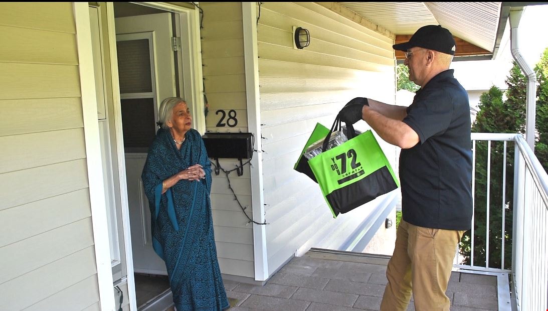
Thank you from City of Burnaby
https://search.heritageburnaby.ca/link/museumdescription15400
- Repository
- Burnaby Village Museum
- Date
- 9 Apr. 2020
- Collection/Fonds
- Burnaby Village Museum COVID-19 collection
- Description Level
- Item
- Physical Description
- 1 video recording (mp4) (58 sec.) : digital, 24 fps, col., sd., stereo
- Scope and Content
- Film clip of Burnaby Mayor Mike Hurley and Burnaby City staff showing their appreciation to frontline workers, first responders and healthcare workers during the COVID-19 pandemic. Burnaby City Hall and other city facilities have decorated windows with colourful hearts and staff members are standin…
- Repository
- Burnaby Village Museum
- Collection/Fonds
- Burnaby Village Museum COVID-19 collection
- Description Level
- Item
- Physical Description
- 1 video recording (mp4) (58 sec.) : digital, 24 fps, col., sd., stereo
- Scope and Content
- Film clip of Burnaby Mayor Mike Hurley and Burnaby City staff showing their appreciation to frontline workers, first responders and healthcare workers during the COVID-19 pandemic. Burnaby City Hall and other city facilities have decorated windows with colourful hearts and staff members are standing outside buildings holding hearts of appreciation. The film closes with people holding hearts and conveying words of thanks in multiple languages.
- History
- Video taken by the City of Burnaby Marketing Department in 2020. The original intent of the clip was to produce communications about the pandemic and changes throughout the City that residents needed to be aware of.
- Creator
- City of Burnaby
- Subjects
- Officials - Mayors and Reeves
- Public Services - Health Services
- Public Services - Municipal Services
- Pandemics - COVID-19
- Geographic Access
- Canada Way
- Street Address
- 4949 Canada Way
- Accession Code
- BV021.2.14
- Access Restriction
- No restrictions
- Reproduction Restriction
- May be restricted by third party rights
- Date
- 9 Apr. 2020
- Media Type
- Moving Images
- Historic Neighbourhood
- Burnaby Lake (Historic Neighbourhood)
- Planning Study Area
- Douglas-Gilpin Area
- Notes
- Title based on contents of film
Images

Video
Thank you from City of Burnaby, 9 Apr. 2020
Thank you from City of Burnaby, 9 Apr. 2020
https://search.heritageburnaby.ca/media/hpo/_Data/_BVM_Moving_Images/2021_0002_0014_001.mp4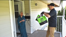
Thank you to citizens of Burnaby
https://search.heritageburnaby.ca/link/museumdescription15399
- Repository
- Burnaby Village Museum
- Date
- May 2020
- Collection/Fonds
- Burnaby Village Museum COVID-19 collection
- Description Level
- Item
- Physical Description
- 1 video recording (mp4) (1 min., 37 sec.) : digital, 24 fps, col., sd., stereo
- Scope and Content
- Film clip from the City of Burnaby thanking it's citizens for helping to flatten the curve of the spread of COVID-19 in the community. Mayor Mike Hurley and narrator communicate that commitments made by citizens have helped set the stage for less restrictions whereby some facilities can be reopened…
- Repository
- Burnaby Village Museum
- Collection/Fonds
- Burnaby Village Museum COVID-19 collection
- Description Level
- Item
- Physical Description
- 1 video recording (mp4) (1 min., 37 sec.) : digital, 24 fps, col., sd., stereo
- Scope and Content
- Film clip from the City of Burnaby thanking it's citizens for helping to flatten the curve of the spread of COVID-19 in the community. Mayor Mike Hurley and narrator communicate that commitments made by citizens have helped set the stage for less restrictions whereby some facilities can be reopened in a safe manner by following the guidelines from the Provincial Health Officer, Dr. Bonnie Henry. Film clip includes a compilation of footage taken by the City's marketing department between March and May 2020. Background music "We're all in this together"is written and performed by Joe Keithley and Mayor Mike Hurley.
- History
- Video taken by the City of Burnaby Marketing Department in 2020. The original intent of the clip was to produce communications about the pandemic and changes throughout the City that residents needed to be aware of.
- Creator
- City of Burnaby
- Geographic Access
- Canada Way
- Street Address
- 4949 Canada Way
- Accession Code
- BV021.2.13
- Access Restriction
- No restrictions
- Reproduction Restriction
- May be restricted by third party rights
- Date
- May 2020
- Media Type
- Moving Images
- Historic Neighbourhood
- Burnaby Lake (Historic Neighbourhood)
- Planning Study Area
- Douglas-Gilpin Area
- Notes
- Title based on contents of film
Images
Video
Thank you to citizens of Burnaby, May 2020
Thank you to citizens of Burnaby, May 2020
https://search.heritageburnaby.ca/media/hpo/_Data/_BVM_Moving_Images/2021_0002_0013_001.mp4