Narrow Results By
Subject
- Accidents - Automobile Accidents 1
- Advertising Medium - Signs and Signboards 17
- Agriculture - Farms 1
- Animals - Cats 1
- Building Components 1
- Buildings 8
- Buildings - Agricultural 1
- Buildings - Civic 1
- Buildings - Civic - Art Galleries 3
- Buildings - Civic - Fire Halls 1
- Buildings - Civic - Hospitals 5
- Buildings - Civic - Libraries 1
![West Burnaby teachers and trophies, [191-] thumbnail](/media/hpo/_Data/_BVM_Images/2012/2012_0020_0004_001.jpg?width=280)
West Burnaby teachers and trophies
https://search.heritageburnaby.ca/link/museumdescription2941
- Repository
- Burnaby Village Museum
- Date
- [191-]
- Collection/Fonds
- Burnaby Village Museum Photograph collection
- Description Level
- Item
- Physical Description
- 1 photograph : b&w ; 8.5 x 11 cm
- Scope and Content
- Photograph of seven teachers standing behind a table with trophies at the entrance to West Burnaby School (Kingway West School). The group is standing at the foot of the front steps to the school, behind a table draped with a Union Jack flag with three trophies on top. Teachers are identified as; …
- Repository
- Burnaby Village Museum
- Collection/Fonds
- Burnaby Village Museum Photograph collection
- Description Level
- Item
- Physical Description
- 1 photograph : b&w ; 8.5 x 11 cm
- Scope and Content
- Photograph of seven teachers standing behind a table with trophies at the entrance to West Burnaby School (Kingway West School). The group is standing at the foot of the front steps to the school, behind a table draped with a Union Jack flag with three trophies on top. Teachers are identified as; Mr. Brown (second from left), Miss Annie Theresa Forrest (third from left), Miss Brice (center), Miss Gray (second from right) and Miss Morrow (far right).
- Subjects
- Occupations - Teachers
- Geographic Access
- Kingsway
- Street Address
- 4800 Kingsway
- Accession Code
- BV012.20.4
- Access Restriction
- No restrictions
- Reproduction Restriction
- No known restrictions
- Date
- [191-]
- Media Type
- Photograph
- Historic Neighbourhood
- Central Park (Historic Neighbourhood)
- Planning Study Area
- Maywood Area
- Scan Resolution
- 600
- Scan Date
- 13-Mar-2018
- Notes
- Title based on contents of photograph
Images
![West Burnaby teachers and trophies, [191-] thumbnail](/media/hpo/_Data/_BVM_Images/2012/2012_0020_0004_001.jpg)
Love family fonds
https://search.heritageburnaby.ca/link/museumdescription10098
- Repository
- Burnaby Village Museum
- Date
- 1881-1971
- Collection/Fonds
- Love family fonds
- Description Level
- Fonds
- Physical Description
- 11 cm of textual records + 44 photographs + 5 plans
- Scope and Content
- Fonds consists of family records including photographs, land sale records, agreements and plans as well as estate records, vital event documentation and correspondence. Records pertain to members of the Love family including the Parkers, Hughes and Leonards. Fonds has been arranged in the followin…
- Repository
- Burnaby Village Museum
- Collection/Fonds
- Love family fonds
- Description Level
- Fonds
- Physical Description
- 11 cm of textual records + 44 photographs + 5 plans
- Scope and Content
- Fonds consists of family records including photographs, land sale records, agreements and plans as well as estate records, vital event documentation and correspondence. Records pertain to members of the Love family including the Parkers, Hughes and Leonards. Fonds has been arranged in the following series: 1) Love and Leonard land records 2) Love family vital events and correspondence 3) Love family photographs
- History
- Jesse Love was born in Swindon, England in 1847 and left England to work on a dairy farm in the Toronto area. While working on the farm in Toronto, he met Martha Leonard who he married in 1879. Martha was born on February 3, 1858 in Bedfordshire, England and had come to Canada with her parents George and Ann Leonard. While living in Toronto, Jesse and Martha had two children, George born March 22, 1880 and Annie Elizabeth on August 24, 1881. About one year after Annie was born, the Love family moved to North Dakota to grow wheat. While living there, they had two more children, Henry who was born August 24, 1883 and Edith Minnie born October 9, 1885. The family decided to move further west after hearing about the fairer weather conditions from Martha’s father, George Leonard, who had settled in Vancouver in 1885. On May 23, 1887, Jesse, Martha and their four children arrived in Vancouver after travelling across Canada from Winnipeg on the first transcontinental train. The Loves made their home in Vancouver while Jesse helped clear land on Granville Street. Their fifth child, Thomas Robert was born on September 17, 1887 and soon after, the family moved to Lulu Island in Richmond where they lived growing vegetables and selling them to Vancouver hotels. While living and farming on Lulu island, the couple had two more girls, Martha (Dot or Dorothy) born on December 17, 1889 and Sarah Marie, born February 8, 1892. On October 6, 1893 an agreement was signed by Jesse Love to purchase 14.52 acres of land from Joseph C. Armstrong. The acreage covered the north east section of District Lot 25 within the newly incorporated District of the Municipality of Burnaby. It was here where the original Love house was built (between October 1893 and April 15, 1894) by Jesse Love with the help of local builder George Salt and father in law, George Leonard. The house consisted of an entrance hall, dining room, lean to kitchen, master bedroom and three bedrooms upstairs. A road was constructed and named Cumberland in 1905 and ran from District Lot 25 through to District Lot 11. The address for the Love home was 1390 Cumberland Road and in the early 1960’s the address was renumbered 7651 Cumberland Street. On the land surrounding the house, Jesse Love planted an orchard along with strawberries and raspberries which he sold at the Fraser Valley Market, T.S. Anandale’s Grocery Store in New Westminster and to hotels around Vancouver. Jesse Love served on the Burnaby School Board and also as a District Councillor in 1901 and from 1904-1907. While living in the house, Jesse and Martha had four more children, Phoebe Leonard, born April 15, 1894, Esther, born August 28, 1896, John Leonard, born June 7, 1899 and Hannah Victoria (also known as Girlie) who was born May 12, 1902. In 1918, at the age of 31 years, Thomas Robert Love fell ill due to an influenza epidemic and died on November 23, 1918. Following their son’s death, Martha Love became weak and on August 24, 1920, she passed away. By this time, Jesse had sold off a large percentage of his land and his youngest daughter, Girlie decided to stay on to live and care for him. Since the house was too large for just the two of them, Jesse invited any other children to return and share the residence. For a while his son, George and his wife joined them. In 1925 Jesse’s daughter Sarah Parker (nee Love), her husband William Michael Norton Parker and their three children, Albert “Bert” (1915-2011), William Charles “Bill” and Elsie Roberta moved from their home at 1319 Newcombe Street to join Jesse and Girlie in the Love family home on Cumberland. Jesse Love died in 1928 after which Sarah and William Parker purchased the Love family farmhouse and property. William Michael Parker, died in 1961 and Sarah Parker continued to live in the Love family farmhouse until 1966 when she sold it to her daughter Elsie and husband John Hughes. Elsie and John Hughes had four children, John Jr., Ann, Brent and Merle. The Hughes lived in the Love family house until August 1971. In 1988 the Love family farmhouse house was donated to the Burnaby Village Museum and moved to the site of Burnaby Village Museum. The interior of the main floor and exterior of the house went through an extensive restoration process. In 1997, restoration of the kitchen was completed and opened to the public. After the completion of the hallway, dining room, main floor bedroom and parlour, the Love farmhouse exhibit opened on November 29, 1998 with an open invitation to the public and extended members of the Love family.
- Responsibility
- Love Family
- Accession Code
- HV979.40
- BV985.3136
- BV988.45
- BV989.3
- BV992.15
- BV992.26
- BV992.34
- BV000.45
- BV008.20
- BV012.31
- BV019.3
- BV019.8
- Date
- 1881-1971
- Media Type
- Textual Record
- Photograph
- Cartographic Material
- Arrangement
- Fonds has been arranged by record type and original order provided by members of the Love family.
- Notes
- Title based on contents of fonds
- See also Burnaby Village Museum fonds - Jesse Love farmhouse series

Charles R. Shaw House
https://search.heritageburnaby.ca/link/landmark525
- Repository
- Burnaby Heritage Planning
- Description
- The Charles R. Shaw House is a one and one-half storey plus basement wood-frame late Victorian era residence, located on the grounds of the Normanna Rest Home development in East Burnaby, near its original location on this site. Originally a modest vernacular Victorian structure, it has been enlarg…
- Associated Dates
- 1891
- Formal Recognition
- Heritage Designation, Community Heritage Register
- Other Names
- Charles R. & Mary Shaw House
- Street View URL
- Google Maps Street View
- Repository
- Burnaby Heritage Planning
- Other Names
- Charles R. & Mary Shaw House
- Geographic Access
- 12th Avenue
- 4th Street
- 13th Avenue
- Associated Dates
- 1891
- Formal Recognition
- Heritage Designation, Community Heritage Register
- Enactment Type
- Bylaw No. 10739
- Enactment Date
- 06/04/1998
- Description
- The Charles R. Shaw House is a one and one-half storey plus basement wood-frame late Victorian era residence, located on the grounds of the Normanna Rest Home development in East Burnaby, near its original location on this site. Originally a modest vernacular Victorian structure, it has been enlarged and embellished through later additions.
- Heritage Value
- The Shaw House is one of the oldest surviving houses in Burnaby, and is valued as a representation of a typical vernacular pioneer house in Burnaby, and a rare survivor from the late Victorian era. The original portion of the house displays a simplicity of form and detail consistent with early local construction, while the later additions display a more sophisticated approach. Originally built in 1891, this house is valued for its association with first owner, Charles R. Shaw (1834-1916) and Mary D. Shaw (1848-1897), one of Burnaby’s earliest settlers. Born in England, Shaw immigrated to Toronto in 1869, and relocated to New Westminster in 1889, where he worked as an employee of the Mechanic's Mill Company, an early woodworking plant. After moving to Burnaby, he was unanimously elected by acclamation as first reeve (mayor) of the new municipality in 1892. In 1894, Shaw sold his house and farm and moved his family to Kamloops due to his wife Mary's failing health. After Mary died in 1897, the Shaw family returned to Toronto. The Shaw House is additionally valued for its association with a later owner, James Brookes (1884-1953), founder of James Brookes Woodworking Ltd., a mill that was a major employer in East Burnaby. Brookes bought and renovated the house in 1917. In 1927, he built a much larger house on the property (now demolished), and the original house was moved to the corner of the property to serve as a gardener's cottage for Brookes' estate. The additions made to the house at this time employed sash and milled products produced by the Brookes plant. Although altered, this Victorian era residence remains largely intact, with Brookes’s later additions.
- Defining Elements
- Key elements that define the heritage character of the Shaw House include its: - modest vernacular residential form, scale and massing, as exemplified by its one and one-half storey plus basement height, front gabled roof, shed roofed verandah and asymmetrical plan - asymmetrical front entrance - cladding: horizontal wooden drop siding on the original portion of the house; cedar shingles on additions; decorative octagonal cedar shingles in the front gable; original decorated bargeboards at front, with cut-out details - later renovations to the front verandah and side addition which resulted in a partially glazed porch entrance and addition with large window assemblies - square verandah columns - irregular fenestration: double-hung wooden-sash windows in a variety of configurations such as 6-over-1 and 4-over-1 windows in the original portion of the house, 12-over-1 windows, and one 24-over-1 window in the front addition - small window at front entry - fifteen-pane French front entry door - internal red brick chimney with corbelled cap
- Historic Neighbourhood
- East Burnaby (Historic Neighbourhood)
- Planning Study Area
- Edmonds Area
- Function
- Primary Historic--Single Dwelling
- Primary Current--Single Dwelling
- Community
- Burnaby
- Cadastral Identifier
- 003-253-848
- Boundaries
- The Shaw House is comprised of a single residential lot located at 7725 Fourth Street (legal address), Burnaby
- Area
- 9199.27
- Contributing Resource
- Building
- Ownership
- Private
- Names
- Shaw, Charles R
- Street Address
- 7725 4th Street
- Street View URL
- Google Maps Street View
Images


Jesse Love House
https://search.heritageburnaby.ca/link/landmark540
- Repository
- Burnaby Heritage Planning
- Description
- The Jesse Love House is a vernacular example of a late Victorian-era wood-frame farmhouse with later Arts and Crafts alterations and additions, that has been relocated to the Burnaby Village Museum. This two-storey house has an L-shaped plan, with a compound gabled roof, overhanging eaves and a lar…
- Associated Dates
- 1893
- Formal Recognition
- Heritage Designation, Community Heritage Register
- Other Names
- Jesse & Martha Love Farmhouse
- Street View URL
- Google Maps Street View
- Repository
- Burnaby Heritage Planning
- Other Names
- Jesse & Martha Love Farmhouse
- Geographic Access
- Deer Lake Avenue
- Associated Dates
- 1893
- Formal Recognition
- Heritage Designation, Community Heritage Register
- Enactment Type
- Bylaw No. 9807
- Enactment Date
- 23/11/1992
- Description
- The Jesse Love House is a vernacular example of a late Victorian-era wood-frame farmhouse with later Arts and Crafts alterations and additions, that has been relocated to the Burnaby Village Museum. This two-storey house has an L-shaped plan, with a compound gabled roof, overhanging eaves and a large wraparound verandah.
- Heritage Value
- The value of the Jesse Love House lies in its comprehensive representation of an early Burnaby farmhouse, and the typical additive growth of a home as the resident family prospered. Jesse Love (1849-1928) and his wife Martha Love (1858-1920) moved to Burnaby in 1893 with their family to start a fruit ranch and market garden on Cumberland Road in the East Burnaby district. Jesse Love was actively involved in community affairs, serving on the Burnaby School Board and also as a District Councillor in 1901 and from 1904-07. The original house was constructed by local builder George Salt and consisted of an entrance hall, dining room, lean-to kitchen, master bedroom and several rooms upstairs. As the family grew and prospered, additions were made to the house including a parlour, more bedrooms upstairs, and a large permanent kitchen. Jesse Love was actively involved in community affairs, and the kitchen became a local gathering spot for political discussion and civic organizations. The verandah, exterior shingle cladding, large windows, running water and electricity were eventually added as well. The heritage value for this house also lies in its interpretive value within the Burnaby Village Museum. The site is an important cultural feature for the interpretation of Burnaby’s heritage to the public. The house was moved to the Burnaby Village Museum in 1988 and both the interior and exterior were restored and interpreted to their 1925 period, including reproduction wallpaper.
- Defining Elements
- The character defining features of the Jesse Love House include its: - irregular form and massing - compound gable roof with cedar shingle cladding - Craftsman-style exterior features such as a shingled exterior and triangular eave brackets - multi-paned double-hung 2-over-2 wooden-sash windows; casement window assemblies with transoms in the Living Room - large wrap-around verandah - interior features such as pressed tin ceilings, original wallpapers and cedar panelled kitchen - reproduction Arts and Crafts parlour document wallpaper and border
- Locality
- Deer Lake Park
- Historic Neighbourhood
- Burnaby Lake (Historic Neighbourhood)
- Planning Study Area
- Morley-Buckingham Area
- Organization
- Burnaby Village Museum
- Builder
- George Salt
- Function
- Primary Current--Museum
- Primary Historic--Single Dwelling
- Community
- Burnaby
- Cadastral Identifier
- P.I.D. No. 011-030-356 Legal Description: Parcel 1, District Lot 79 and District Lot 85, Group 1, New Westminster District, Reference Plan 77594
- Boundaries
- Burnaby Village Museum is comprised of a single municipally-owned property located at 6501 Deer Lake Avenue, Burnaby.
- Area
- 38,488.63
- Contributing Resource
- Building
- Landscape Feature
- Structure
- Ownership
- Public (local)
- Documentation
- Heritage Site Files: PC77000 20. City of Burnaby Planning and Building Department, 4949 Canada Way, Burnaby, B.C., V5G 1M2
- Street Address
- 6501 Deer Lake Avenue
- Street View URL
- Google Maps Street View
Images


Jesse Love farmhouse series
https://search.heritageburnaby.ca/link/museumdescription9782
- Repository
- Burnaby Village Museum
- Date
- [1893-1970] (date of originals), copied 1988-1998, predominant 1988-2000
- Collection/Fonds
- Burnaby Village Museum fonds
- Description Level
- Series
- Physical Description
- approx. 84 cm of textual records + approx. 1,910 photographs + approx. 100 architectural drawings + 3 audio cassettes + 1 videocassette
- Scope and Content
- Series consists of records involved in the purchase, moving, restoration, research, conservation and exhibiting of the Love family farmhouse by Burnaby Village Museum. Records have been arranged into the following subseries: 1) Love farmhouse conservation work files subseries 2) Love farmhouse re…
- Repository
- Burnaby Village Museum
- Collection/Fonds
- Burnaby Village Museum fonds
- Series
- Jesse Love farmhouse series
- Description Level
- Series
- Physical Description
- approx. 84 cm of textual records + approx. 1,910 photographs + approx. 100 architectural drawings + 3 audio cassettes + 1 videocassette
- Scope and Content
- Series consists of records involved in the purchase, moving, restoration, research, conservation and exhibiting of the Love family farmhouse by Burnaby Village Museum. Records have been arranged into the following subseries: 1) Love farmhouse conservation work files subseries 2) Love farmhouse restoration photographs subseries 3) Love farmhouse curatorial files subseries 4) Love farmouse research files subseries 5) Love family photographs 6) Love farmhouse Oral History subseries 7) Love farmhouse architectural drawings subseries
- History
- Jesse Love was born in Swindon, England in 1847 and left England to work on a dairy farm in the Toronto area. While working on the farm in Toronto, he met Martha Leonard who he married in 1879. Martha was born on February 3, 1858 in Bedfordshire, England and had come to Canada with her parents George and Ann Leonard. While living in Toronto, Jesse and Martha had two children, George born March 22, 1880 and Annie Elizabeth on August 24, 1881. About one year after Annie was born, the Love family moved to North Dakota to grow wheat. While living there, they had two more children, Henry who was born August 24, 1883 and Edith Minnie born October 9, 1885. The family decided to move further west after hearing about the fairer weather conditions from Martha’s father, George Leonard, who had settled in Vancouver in 1885. On May 23, 1887, Jesse, Martha and their four children arrived in Vancouver after travelling across Canada from Winnipeg on the first transcontinental train. The Loves made their home in Vancouver while Jesse helped clear land on Granville Street. Their fifth child, Thomas Robert was born on September 17, 1887 and soon after, the family moved to Lulu Island in Richmond where they lived growing vegetables and selling them to Vancouver hotels. While living and farming on Lulu island, the couple had two more girls, Martha (Dot or Dorothy) born on December 17, 1889 and Sarah Marie, born February 8, 1892. On October 6, 1893 an agreement was signed by Jesse Love to purchase 14.52 acres of land from Joseph C. Armstrong. The acreage covered the north east section of District Lot 25 within the newly incorporated District of the Municipality of Burnaby. It was here where the original Love house was built (between October 1893 and April 15, 1894) by Jesse Love with the help of local builder George Salt and father in law, George Leonard. The house consisted of an entrance hall, dining room, lean to kitchen, master bedroom and three bedrooms upstairs. A road was constructed and named Cumberland in 1905 and ran from District Lot 25 through to District Lot 11. The address for the Love home was 1390 Cumberland Road and in the early 1960’s the address was renumbered 7651 Cumberland Street. On the land surrounding the house, Jesse Love planted an orchard along with strawberries and raspberries which he sold at the Fraser Valley Market, T.S. Anandale’s Grocery Store in New Westminster and to hotels around Vancouver. Jesse Love served on the Burnaby School Board and also as a District Councillor in 1901 and from 1904-1907. While living in the house, Jesse and Martha had four more children, Phoebe Leonard, born April 15, 1894, Esther, born August 28, 1896, John Leonard, born June 7, 1899 and Hannah Victoria (also known as Girlie) who was born May 12, 1902. As the family grew to eleven children, additions along with some substantial remodelling in the craftsman style took place. In about 1898, a north wing addition was added to include a parlour with two windows, the construction of two more bedrooms and the relocation of the stair case to the North West wall. In 1903 the front door moved to the north elevation, a front porch was extended along the east wall and a summer lean to kitchen was added to the west elevation. Between 1905 and 1910, a tin embossed ceiling was installed along with an addition of the main kitchen which included a pantry, bathtub and a back porch. In about 1912, five craftsman style windows replaced the original pioneer tent style, the front verandah was enlarged to wrap around the south and east elevations, a back door was installed in the kitchen to access the verandah and wood shingle siding and brackets were added to the exterior. In 1918, at the age of 31 years, Robert Love fell ill due to an influenza epidemic and died on November 23, 1918. Following their son’s death, Martha Love became weak and on August 24, 1920, she passed away. By this time, Jesse had sold off a large percentage of his land and his youngest daughter, Girlie decided to stay on to live and care for him. Since the house was too large for just the two of them, Jesse invited any other children to return and share the residence. For a while his son, George and his wife joined them until 1925, followed by his daughter Sarah Parker (nee Love), her husband William and their three children, Albert, Bill and Elsie. The house remained pretty unchanged until 1928 after Jesse Love died of pneumonia (March 10, 1928) and the house was purchased by Sarah and her husband William Parker who continued to live there with their children. The master bedroom wall on the main floor opened up to the dining room, the kitchen pantry and bathtub converted to an alcove with a marble counter and enlarged window and sink while the bathroom was moved to the upstairs and the furnace and coolers were installed in the crawl space under the kitchen. A hot water tank was installed in the house in 1966. Sarah continued to live in the house until a little while after her husband William died in 1961. She sold the house to her daughter Elsie and husband John Hughes in 1966, who lived in the house along with their son Brent, until August 23, 1971. Mahbir Molchan Papan and his wife Geraldine Papan bought the house August 23, 1971 and by 1982, the house was sold to Nirmal Singh Singha and Narinder Singha. The Papans continued to rent the house from Nirmal Singh Singha and Narinder Singha until the late 1980s. In 1988, the house was scheduled for demolition with the remaining property to be subdivided. Fortunately, a neighbour, Mr. Harvey Elder recognized the farmhouse's historical significance and contacted the Burnaby Historical Society. Following this event, the owners agreed to donate the building to the Burnaby Village Museum (under the Century Park Museum Association) who financed the move of the house from Cumberland Street to the museum site. Heritage planner and architect, Robert Lemon provided guidance for the project. Prior to the move, the two porches were removed and demolished while the kitchen and roof were both separated from the main house. The kitchen and roof of the house were transported to Burnaby Village Museum on May 20, 1988 by Nickel Bros. House Moving company, while the main frame of the house completed its transportation to the museum near the end of May 1988 (due to low overhead wires). The house was moved down Cumberland Street to 10th Avenue, up Canada Way to Sperling and set on temporary footings near Hart House. Robert Lemon oversaw structural improvements such as, upgrading floor joists and creating new foundations to replace the original timber foundation of the farmhouse. The restoration went through several phases of work between 1988 until it opened in November 1998. Restoration began on both the interior and exterior features to be interpreted from the period of 1925. On November 23, 1992, the building was designated a heritage building under Heritage Designation Bylaw 1992, Bylaw Number 9807. In 1993, the architecture firm of Brian G. Hart Associates was appointed for the design and construction supervision of the restoration project. Plans were created for a foundation on the museum site in 1989 and the farmhouse was eventually settled on a permanent foundation behind the Burnaby Village Museum administration building in 1993 along with the reattachment of the roof. The kitchen section was reattached to the main house in 1994 along with skirting around the foundation and the reshingling of the exterior. In 1996, the tin ceiling was removed to make way for the installation of the internal electrical system along with sprinklers, ceiling heating and fire break gyprock. The dining room ceiling joists were consolidated, a pantry and bathroom were added to the kitchen, the downstairs bedroom wall was opened and filled, the dining and kitchen doorways were widened. In 1997, a wheelchair ramp was installed along with a concrete sidewalk, stair rails, cement pads at the base of the stairs and a gravel sink for any excess water. Interior work included painting of the kitchen, restoration and furnishing of the kitchen pantry, insulation of the house floor to protect from rodents along with the reconstruction of the kitchen and house chimneys. The registrar worked together with the curator and conservator and was tasked with a large research project on the house including the family contacts and family history, property information, plans, photographs, artifacts, furnishings, stories etc. all organized in files for easy retrieval. A great deal of research and conservation was undertaken in order to make the interior of the house authentic to the time period as possible. One of the biggest projects was selecting and obtaining wall coverings since much of the original wallpaper was incomplete and poor condition. The conservator and registrar were lucky enough to locate a few samples of the original paper and engage the Bradbury and Bradbury Art Wallpaper Company of Benica, California to reproduce replica designs for free. The City of Burnaby now has its own series “Burnaby Village Papers” produced by this company which are titled “Burnaby Wall”; “Burnaby Border” and “Burnaby Ceiling”. All three of these wallpaper designs have been used in the Love farm house and are also commercially available through the Bradbury and Bradbury Art Wallpaper Company. In 1997, restoration of the kitchen was completed and opened to the public. After the completion of the dining room, main floor bedroom and parlour, the Love farmhouse exhibit opened on November 29, 1998 with an open invitation to the public and extended members of the Love family. Officials including the Mayor, Doug Drummond and Love family members were all present to cut the ribbon for the special event.
- Accession Code
- BV018.41; BV020.5
- Access Restriction
- Restricted access
- Date
- [1893-1970] (date of originals), copied 1988-1998, predominant 1988-2000
- Arrangement
- The majority of the records within series and subseries were arranged by a staff members of Burnaby Village Museum who worked on the historical research and restoration of the house. Other photographs documenting the move and further restoration work were added later and included in the arrangment by format and subject.
- Notes
- Title based on content of series
- Jesse Love farmhouse is described as an Artifact under BV988.33.1
- Some records within this collection have restricted access and are subject to FIPPA
- Accessions BV018.41 and BV020.5 form this fonds
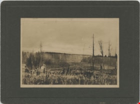
Looking from Woodlunds towards Burnaby Lake in 1899
https://search.heritageburnaby.ca/link/museumdescription992
- Repository
- Burnaby Village Museum
- Date
- 1899
- Collection/Fonds
- Burnaby Village Museum Photograph collection
- Description Level
- Item
- Physical Description
- 1 photograph : sepia photogravure ; 9.8 x 13.9 cm, mounted on cardboard 14.5 x 19.7 cm
- Scope and Content
- Photograph taken from "Woodlunds." Annotations in ink on the back of the card read, "Mr & Mrs G. Every-Clayton/ with Mr Haszard's/ wishes for a very/ Happy Xmas/ 1899" and "Looking from Woodlands / towards Burnaby Lake in 1899." Later annotation in blue ballpoint pen read, "Woodlunds the residence…
- Repository
- Burnaby Village Museum
- Collection/Fonds
- Burnaby Village Museum Photograph collection
- Description Level
- Item
- Physical Description
- 1 photograph : sepia photogravure ; 9.8 x 13.9 cm, mounted on cardboard 14.5 x 19.7 cm
- Scope and Content
- Photograph taken from "Woodlunds." Annotations in ink on the back of the card read, "Mr & Mrs G. Every-Clayton/ with Mr Haszard's/ wishes for a very/ Happy Xmas/ 1899" and "Looking from Woodlands / towards Burnaby Lake in 1899." Later annotation in blue ballpoint pen read, "Woodlunds the residence of Mr. Geo. Every-Clayton stood on the site of the present Centennial Pavilion, which when originally built was the residence of Mr. and Mrs. H.T. Ceperley. The proceeds from its sale was used to prepare the Ceperley playground in Stanley Park. The house in the left centre was that of Mr. and Mrs. Bernard R. Hill demolished to make way for entrance to Expressway."
- Names
- Every-Clayton, George
- Geographic Access
- Burnaby Lake
- Accession Code
- HV973.40.6
- Access Restriction
- No restrictions
- Reproduction Restriction
- No known restrictions
- Date
- 1899
- Media Type
- Photograph
- Scan Resolution
- 600
- Scan Date
- 2023-05-09
- Scale
- 100
- Notes
- Title based on contents of photograph
Images

![Seated on a lawn, [190-] thumbnail](/media/hpo/_Data/_BVM_Images/1983/1983_0042_0053_001.jpg?width=280)
Seated on a lawn
https://search.heritageburnaby.ca/link/museumdescription313
- Repository
- Burnaby Village Museum
- Date
- [190-]
- Collection/Fonds
- Burnaby Village Museum Photograph collection
- Description Level
- Item
- Physical Description
- 1 photograph : b&w ; 8.6 x 14.1 cm
- Scope and Content
- Photograph of two women seated on a lawn. Behind them, a large multi-storey building with multiple bays and a grand entrance can be seen. One of the women is wearing a striped dress with shoes with buckles. The other woman is wearing a long polka dot dress. The woman in the polka dot dress rese…
- Repository
- Burnaby Village Museum
- Collection/Fonds
- Burnaby Village Museum Photograph collection
- Description Level
- Item
- Physical Description
- 1 photograph : b&w ; 8.6 x 14.1 cm
- Scope and Content
- Photograph of two women seated on a lawn. Behind them, a large multi-storey building with multiple bays and a grand entrance can be seen. One of the women is wearing a striped dress with shoes with buckles. The other woman is wearing a long polka dot dress. The woman in the polka dot dress resembles the woman in other photographs in this accession identified as Gloriana Bird, or Birdie.
- Names
- Bird, Gloriana "Birdie"
- Accession Code
- HV983.42.53
- Access Restriction
- No restrictions
- Reproduction Restriction
- No known restrictions
- Date
- [190-]
- Media Type
- Photograph
- Scan Resolution
- 600
- Scan Date
- 2023-10-31
- Notes
- Title based on contents of photograph
Images
![Seated on a lawn, [190-] thumbnail](/media/hpo/_Data/_BVM_Images/1983/1983_0042_0053_001.jpg)
![Family in front of their house, [190-] thumbnail](/media/hpo/_Data/_BVM_Images/1983/1983_0042_0069_001.jpg?width=280)
Family in front of their house
https://search.heritageburnaby.ca/link/museumdescription329
- Repository
- Burnaby Village Museum
- Date
- [190-]
- Collection/Fonds
- Burnaby Village Museum Photograph collection
- Description Level
- Item
- Physical Description
- 1 photograph : b&w ; 8.3 x 5.8 cm
- Scope and Content
- Photograph of an unidentified family of three, a woman, a man and a girl, standing in front of a large two storey house with an attic and large porch around the front entrance. The house appears to be under construction or just finished being constructed. There are pipes and possibly a ditch in f…
- Repository
- Burnaby Village Museum
- Collection/Fonds
- Burnaby Village Museum Photograph collection
- Description Level
- Item
- Physical Description
- 1 photograph : b&w ; 8.3 x 5.8 cm
- Material Details
- inscribed in black ink, verso, c. "Pa looks as if/ he had a wooden/ leg.", l.r. " "ha ha" "
- Scope and Content
- Photograph of an unidentified family of three, a woman, a man and a girl, standing in front of a large two storey house with an attic and large porch around the front entrance. The house appears to be under construction or just finished being constructed. There are pipes and possibly a ditch in front of the house. The location is not identified. An annotation on the back of the photo reads: "Pa looks as if He had a wooden leg. / 'ha, ha'."
- Subjects
- Buildings - Residential - Houses
- Accession Code
- HV983.42.69
- Access Restriction
- No restrictions
- Reproduction Restriction
- No known restrictions
- Date
- [190-]
- Media Type
- Photograph
- Scan Resolution
- 600
- Scan Date
- 2023-09-26
- Notes
- Title based on contents of photograph
Images
![Family in front of their house, [190-] thumbnail](/media/hpo/_Data/_BVM_Images/1983/1983_0042_0069_001.jpg)
![Cathedral Ruins, [190-] thumbnail](/media/hpo/_Data/_BVM_Images/1973/1973_0050_0074_001.jpg?width=280)
Cathedral Ruins
https://search.heritageburnaby.ca/link/museumdescription3066
- Repository
- Burnaby Village Museum
- Date
- [190-]
- Collection/Fonds
- Burnaby Village Museum Photograph collection
- Description Level
- Item
- Physical Description
- 1 photograph : b&w glass negative ; 17.8 x 12.7 cm
- Scope and Content
- Photograph of entrance way or the front wall of the ruins of an unidentified cathedral built in gothic style architecture.
- Repository
- Burnaby Village Museum
- Collection/Fonds
- Burnaby Village Museum Photograph collection
- Description Level
- Item
- Physical Description
- 1 photograph : b&w glass negative ; 17.8 x 12.7 cm
- Scope and Content
- Photograph of entrance way or the front wall of the ruins of an unidentified cathedral built in gothic style architecture.
- Subjects
- Buildings - Religious - Churches
- Accession Code
- HV973.50.74
- Access Restriction
- No restrictions
- Reproduction Restriction
- May be restricted by third party rights
- Date
- [190-]
- Media Type
- Photograph
- Scan Resolution
- 600
- Scan Date
- 2023-06-15
- Notes
- Title based on contents of photograph
- 1 b&w photograph accompanying
Images
![Cathedral Ruins, [190-] thumbnail](/media/hpo/_Data/_BVM_Images/1973/1973_0050_0074_001.jpg)
![Boat anchored on a lake, [190-] thumbnail](/media/hpo/_Data/_BVM_Images/2022/2022_0032_0006_001.jpg?width=280)
Boat anchored on a lake
https://search.heritageburnaby.ca/link/museumdescription19289
- Repository
- Burnaby Village Museum
- Date
- [190-]
- Collection/Fonds
- Esther Love Stanley fonds
- Description Level
- Item
- Physical Description
- 1 photograph : b&w ; 6 x 10.5 cm
- Scope and Content
- Photograph of a boat anchored on an unidentified lake. A man is standing under a shelter at the bow of the boat near the cabin entrance. The tree-lined shore line is visible behind.
- Repository
- Burnaby Village Museum
- Collection/Fonds
- Esther Love Stanley fonds
- Description Level
- Item
- Physical Description
- 1 photograph : b&w ; 6 x 10.5 cm
- Scope and Content
- Photograph of a boat anchored on an unidentified lake. A man is standing under a shelter at the bow of the boat near the cabin entrance. The tree-lined shore line is visible behind.
- Accession Code
- BV022.32.6
- Access Restriction
- No restrictions
- Reproduction Restriction
- No known restrictions
- Date
- [190-]
- Media Type
- Photograph
- Scan Resolution
- 600
- Scan Date
- 2023-04-04
- Notes
- Title based on contents of photograph
- Photograph is part of Esther Love Stanley photograph album 1 (BV022.32.1)
Images
![Boat anchored on a lake, [190-] thumbnail](/media/hpo/_Data/_BVM_Images/2022/2022_0032_0006_001.jpg)

St. John the Divine Anglican Church
https://search.heritageburnaby.ca/link/landmark514
- Repository
- Burnaby Heritage Planning
- Description
- St. John the Divine Anglican Church is a landmark wood-frame Gothic Revival church, with Gothic windows and spire. It is located on Kingsway, one of Burnaby’s main commercial thoroughfares, near the SkyTrain transit line and across the street from Central Park.
- Associated Dates
- 1905
- Formal Recognition
- Community Heritage Register
- Street View URL
- Google Maps Street View
- Repository
- Burnaby Heritage Planning
- Geographic Access
- Kingsway
- Associated Dates
- 1905
- Formal Recognition
- Community Heritage Register
- Enactment Type
- Council Resolution
- Enactment Date
- 09/06/2003
- Description
- St. John the Divine Anglican Church is a landmark wood-frame Gothic Revival church, with Gothic windows and spire. It is located on Kingsway, one of Burnaby’s main commercial thoroughfares, near the SkyTrain transit line and across the street from Central Park.
- Heritage Value
- St. John the Divine Anglican Church is valued as a symbol of the traditions of early Burnaby pioneers and as the oldest surviving church building in the city. Established in 1899, St. John was the first church in the community and was located at a prominent intersection of the old Vancouver-Westminster Road (now Kingsway) and the British Columbia Electric Railway’s interurban station at Central Park. This prominent intersection of the road and rail developed as the town centre of the Central Park district. The first St. John church was destroyed by fire, and was rebuilt at the same location in 1904-05. This church is additionally significant for its association with prominent local architect Joseph Henry Bowman (1864-1943) who emigrated from England in 1888. Bowman was a member of the parish, and designed both the first church and its subsequent replacement. Bowman’s prolific career embraced many stylistic changes and technological advances, and this church is a surviving example of one of his rare religious commissions. The design of the new church's nave and vestry was based on the Gothic Revival style of Christ Church Anglican in Surrey, B.C., which had been the former church of St. John’s incumbent Rev. William Bell. Evolving over time as the congregation grew, the church received a number of early additions, and in 1953 was substantially renovated and enlarged through a new design by Vancouver architect Ross Lort. The original church nave was separated from the tower and turned to allow for a large addition. The congregation relocated to a new church in 1998, and at that time removed the church's memorial windows, leaving behind a number of the original art glass windows installed in the 1920s. The church building was renovated in 2004-05, and surviving original elements were retained and restored, including of the original church tower and interior chancel ceiling. A valued feature of the building is the original cast iron church bell that remains in the tower. It was purchased by the children of the congregation in 1912, and in 1924 was rededicated on Armistice Day as a memorial to Burnaby resident Lt. James Donald McRae Reid, who died in the First World War.
- Defining Elements
- Key elements that define the heritage character of St. John the Divine Anglican Church include its: - location on the north side of Kingsway, opposite Central Park - ecclesiastical form, scale and massing as expressed by the offset tower and tall, gabled roof - tower with its original horizontal wooden drop siding, bellcast square roof with octagonal drum above and bellcast octagonal spire - cedar shingle roof cladding - metal cross at peak of spire - Gothic Revival details such as: Gothic lancet windows with leaded stained glass panels; Gothic entrance door at the base of the tower; pointed-arch louvers in the tower; and exterior gable end scissor-trusses - interior features such as wooden scissor-trusses with diagonal fir tongue and groove panelling on the ceiling above, fir tongue-and-groove panelling on the wall of the nave, and original cedar and fir pews and altar rails - cast iron bell in tower
- Historic Neighbourhood
- Central Park (Historic Neighbourhood)
- Planning Study Area
- Garden Village Area
- Architect
- Joesph Henry Bowman
- Function
- Primary Historic--Place of Worship
- Primary Current--Place of Worship
- Community
- Burnaby
- Cadastral Identifier
- 003-398-871
- Boundaries
- St. John the Divine Anglican Church is comprised of a single institutional lot located at 3891 Kingway, Burnaby.
- Area
- 3486.66
- Contributing Resource
- Building
- Ownership
- Private
- Street Address
- 3891 Kingsway
- Street View URL
- Google Maps Street View
Images


The entrance British history notes
https://search.heritageburnaby.ca/link/museumlibrary2840
- Repository
- Burnaby Village Museum
- Collection
- Special Collection
- Material Type
- Book
- Accession Code
- HV973.106.3
- Call Number
- 941 HEN
- Edition
- 8th ed.
- Place of Publication
- Toronto
- Publisher
- The Educational Publishing Co.
- Publication Date
- 1905
- Series
- School helps series
- Physical Description
- [1], 87 p. : maps ; 17 cm.
- Inscription
- "Katie Milton"--inscribed in black ink on verso of front cover and on black fly leaf.
- Library Subject (LOC)
- Great Britain--History
- Notes
- "Entered according to Act of the Parliament of Canada, in the year one thousand eight hundred and ninety-seven, by Geo. E. Henderson and Chas. G. Fraser, at the Department of Agriculture."--title page verso.
- Author(s) full name: Fraser, Charles G. (Charles Gordon), 1861-.

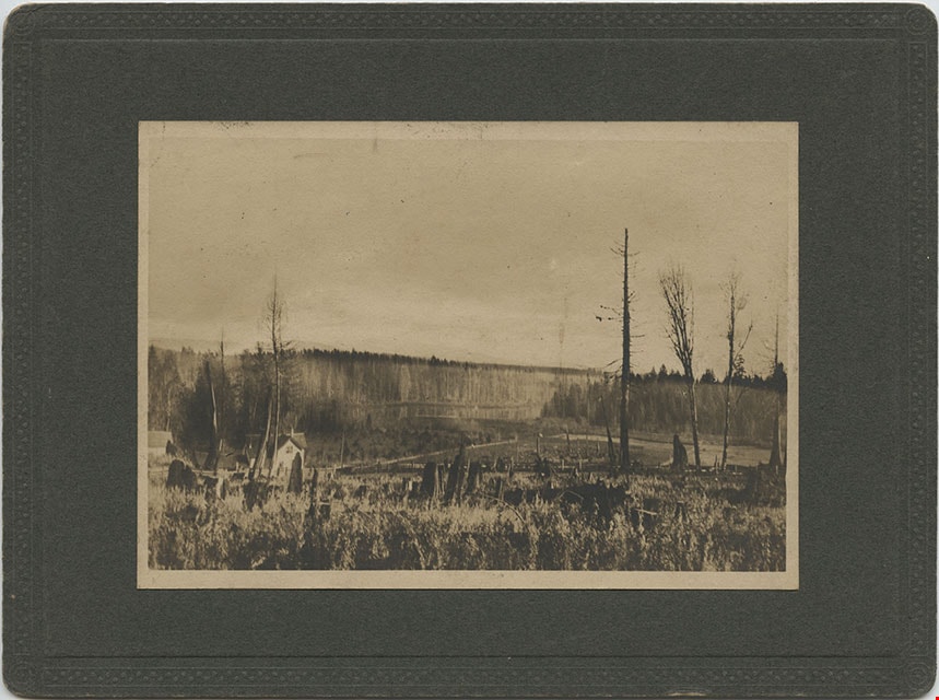
Looking south from Bernard Hill's house
https://search.heritageburnaby.ca/link/archivedescription39527
- Repository
- City of Burnaby Archives
- Date
- 1906
- Collection/Fonds
- Peers Family and Hill Family fonds
- Description Level
- Item
- Physical Description
- 1 photograph : b&w ; 11.8 x 17 cm on page 21.5 x 28 cm (pasted in album)
- Scope and Content
- Photograph of the fields and farmland looking southeast from the home of Bernard Hill down Douglas Road towards Deer Lake Brook. In the foreground view can be seen what is the present-day Kensington Avenue freeway entrance and No. 1 Firehall site on Sperling Avenue. The cabin that can be seen to …
- Repository
- City of Burnaby Archives
- Date
- 1906
- Collection/Fonds
- Peers Family and Hill Family fonds
- Physical Description
- 1 photograph : b&w ; 11.8 x 17 cm on page 21.5 x 28 cm (pasted in album)
- Description Level
- Item
- Record No.
- 477-846
- Access Restriction
- No restrictions
- Reproduction Restriction
- No known restrictions
- Accession Number
- 2007-12
- Scope and Content
- Photograph of the fields and farmland looking southeast from the home of Bernard Hill down Douglas Road towards Deer Lake Brook. In the foreground view can be seen what is the present-day Kensington Avenue freeway entrance and No. 1 Firehall site on Sperling Avenue. The cabin that can be seen to the left in the background is an unknown residence further along Douglas Road near Rayside Drive and the cabin that is just visible in the centre background of the photograph (between treeline split) belonged to Mr. Nicholson. It was later torn down when Bernard Hill's brother Claude Hill built his home, Broadview at that location. To the extreme right of the picture on the opposite side of Douglas Road is the property of Claude Hill's first Burnaby home also known as Brookfield (the current location of the Burnaby Village Museum).
- Subjects
- Agriculture - Farms
- Media Type
- Photograph
- Notes
- Title based on caption accompanying photograph
- Geographic Access
- Douglas Road
- Canada Way
- Deer Lake Brook
- Street Address
- 4990 Canada Way
- Historic Neighbourhood
- Burnaby Lake (Historic Neighbourhood)
- Planning Study Area
- Douglas-Gilpin Area
Images


W.J. Walker House
https://search.heritageburnaby.ca/link/landmark548
- Repository
- Burnaby Heritage Planning
- Description
- The W.J. Walker House is a rustic cottage at the eastern end of Deer Lake and is now located within Deer Lake Park. It is a one-and-a-half-storey wood-frame shingle-clad vernacular structure.
- Associated Dates
- 1907
- Formal Recognition
- Heritage Designation, Community Heritage Register
- Other Names
- William & Olive Walker Residence
- Street View URL
- Google Maps Street View
- Repository
- Burnaby Heritage Planning
- Other Names
- William & Olive Walker Residence
- Geographic Access
- Sperling Avenue
- Associated Dates
- 1907
- Formal Recognition
- Heritage Designation, Community Heritage Register
- Enactment Type
- Bylaw No. 11593
- Enactment Date
- 15/09/2003
- Description
- The W.J. Walker House is a rustic cottage at the eastern end of Deer Lake and is now located within Deer Lake Park. It is a one-and-a-half-storey wood-frame shingle-clad vernacular structure.
- Heritage Value
- The W.J. Walker House is important as it references the economic activities in the Deer Lake area prior to the development of grand mansions in Deer Lake Park. It is typical of the cottages built by workers in the market gardening and lumber-milling industries that operated around the lake primarily from 1904-1925. This is the only cottage on the shores of Deer Lake remaining from the era when these industries were the focus of the area's development. The house demonstrates the aesthetic values of Olive Walker and her husband William J. Walker, a ‘rancher’ (market gardener, poultry farmer) who built the house as a retirement home, in the quality of its construction and interior finishing. The Craftsman styling of the house was a popular design vocabulary of the time and reflected the modern taste and values of the owner. The construction of the house also illustrates the use of locally milled lumber. The extant cold safe at the side of house is indicative of food storage methods in the early twentieth century and provides insight to the everyday domestic lives of people at this time.
- Defining Elements
- Key elements that define the heritage character of the W.J. Walker House include its: - location close to the lake and the site of the Deer Lake Lumber Company where the wood for construction of the house was milled - Craftsman style characteristics such as the house's orientation (front gable facing the street) and the combination of gable and double-pitched shed roofs - front entrance with its gabled porch supported by distinctive oversized diagonal brackets, and substantial front door of Douglas fir decorated with hand forged iron plates - cedar shingle siding - multiple-assembly wooden-sash casement windows with transoms - projecting cold safe - interior finishing that dates to the original construction of the house, such as the diagonally laid tongue-and-groove Douglas fir ceilings, wood panelled walls, and Clayburn brick fireplace
- Historic Neighbourhood
- Burnaby Lake (Historic Neighbourhood)
- Planning Study Area
- Morley-Buckingham Area
- Function
- Primary Current--Single Dwelling
- Primary Historic--Single Dwelling
- Community
- Burnaby
- Cadastral Identifier
- P.I.D. No. 017-105-773 Legal Description: Parcel 'A' (Reference Plan 3703), District Lot 85, Group 1, Except: Firstly: Parcel 'One' (Explanatory Plan 11350) Secondly: Parcel 2 (Reference Plan 35549) Group 1, New Westminster District.
- Boundaries
- The W.J. Walker House is comprised of a single municipally-owned property located at 5255 Sperling Avenue, Burnaby.
- Area
- 2,005.02
- Contributing Resource
- Building
- Landscape Feature
- Ownership
- Public (local)
- Documentation
- Heritage Site Files: PC77000 20. City of Burnaby Planning and Building Department, 4949 Canada Way, Burnaby, B.C., V5G 1M2
- Street Address
- 5255 Sperling Avenue
- Street View URL
- Google Maps Street View
Images


H.T. Ceperley Estate 'Fairacres' Root House
https://search.heritageburnaby.ca/link/landmark527
- Repository
- Burnaby Heritage Planning
- Description
- The ‘Fairacres’ Root House is a long, low one-storey masonry building, measuring 4.6 metres by 9.1 metres, with massively buttressed concrete walls and foundations. Built into sloping ground adjacent to the location of the former greenhouses, the surviving orchard and the kitchen entrance of the ma…
- Associated Dates
- 1908
- Formal Recognition
- Heritage Designation, Community Heritage Register
- Repository
- Burnaby Heritage Planning
- Geographic Access
- Deer Lake Avenue
- Associated Dates
- 1908
- Formal Recognition
- Heritage Designation, Community Heritage Register
- Enactment Type
- Bylaw No. 9807
- Enactment Date
- 23/11/1992
- Description
- The ‘Fairacres’ Root House is a long, low one-storey masonry building, measuring 4.6 metres by 9.1 metres, with massively buttressed concrete walls and foundations. Built into sloping ground adjacent to the location of the former greenhouses, the surviving orchard and the kitchen entrance of the main house, 'Fairacres,' this functional structure was used as a frost-free store for fruit and vegetables for the family's use.
- Heritage Value
- The outbuildings at 'Fairacres' are a rare surviving architecturally-designed ensemble of agricultural structures that exist in complementary harmony with the main estate house. Architect Robert Mackay Fripp (1858-1917), an outspoken advocate of Arts and Crafts design, was retained by the Ceperleys to design several original outbuildings on their estate. The Root House is important as a rare surviving, and exceptionally large, example of this building type in the Vancouver region. Unusual in the fact that an architect designed a building of such modest aspirations, it is also remarkable in its method of construction. The use of concrete as a structural material is one of the earliest in the region and extraordinary for its use on such a modest vernacular outbuilding; root cellars were typically built of loose stone. Built in 1908, the Root House was significantly altered in the 1960s and restored to its original design in 2000. The building is significant as an indicator of the market gardening activity in the area around Deer Lake and of the country-house self-sufficiency practiced by the Ceperley family. The Root House illustrates the cultural, aesthetic, and lifestyle values of the Ceperleys in constructing such a large building for storing their own produce.
- Defining Elements
- The outbuildings at 'Fairacres' are a rare surviving architecturally-designed ensemble of agricultural structures that exist in complementary harmony with the main estate house. Architect Robert Mackay Fripp (1858-1917), an outspoken advocate of Arts and Crafts design, was retained by the Ceperleys to design several original outbuildings on their estate. The Root House is important as a rare surviving, and exceptionally large, example of this building type in the Vancouver region. Unusual in the fact that an architect designed a building of such modest aspirations, it is also remarkable in its method of construction. The use of concrete as a structural material is one of the earliest in the region and extraordinary for its use on such a modest vernacular outbuilding; root cellars were typically built of loose stone. Built in 1908, the Root House was significantly altered in the 1960s and restored to its original design in 2000. The building is significant as an indicator of the market gardening activity in the area around Deer Lake and of the country-house self-sufficiency practiced by the Ceperley family. The Root House illustrates the cultural, aesthetic, and lifestyle values of the Ceperleys in constructing such a large building for storing their own produce.
- Locality
- Deer Lake Park
- Historic Neighbourhood
- Burnaby Lake (Historic Neighbourhood)
- Planning Study Area
- Douglas-Gilpin Area
- Architect
- Robert Mackay Fripp
- Function
- Primary Historic--Outbuilding
- Secondary Historic--Food Storage
- Community
- Burnaby
- Cadastral Identifier
- P.I.D. No. 004-493-311 Legal Description: Block 3 Except: Part subdivided by Plan 26865, District Lot 79, Group 1, New Westminster District, Plan 536
- Boundaries
- ‘Fairacres’ is comprised of a single municipally-owned property located at 6344 Deer Lake Avenue, Burnaby.
- Area
- 17,065.00
- Contributing Resource
- Building
- Landscape Feature
- Ownership
- Public (local)
- Other Collection
- Burnaby Historical Society, Community Archives: Ceperley Photograph Album
- Documentation
- Heritage Site Files: PC77000 20. City of Burnaby Planning and Building Department, 4949 Canada Way, Burnaby, B.C., V5G 1M2
- Street Address
- 6344 Deer Lake Avenue
Images


Joseph Clarke House
https://search.heritageburnaby.ca/link/landmark505
- Repository
- Burnaby Heritage Planning
- Description
- The Joseph Clarke House is a two and one-half storey, wood-frame house, with shingle siding, a front-gabled roof and a full open front verandah. It is located on Jersey Avenue within the Central Park neighbourhood of Burnaby.
- Associated Dates
- 1909
- Formal Recognition
- Heritage Designation, Community Heritage Register
- Other Names
- Joseph & Ellen Clarke House, Clarke Residence
- Street View URL
- Google Maps Street View
- Repository
- Burnaby Heritage Planning
- Other Names
- Joseph & Ellen Clarke House, Clarke Residence
- Geographic Access
- Jersey Avenue
- Sandell Street
- Associated Dates
- 1909
- Formal Recognition
- Heritage Designation, Community Heritage Register
- Enactment Type
- By-law No. 11930
- Enactment Date
- 29/08/2005
- Description
- The Joseph Clarke House is a two and one-half storey, wood-frame house, with shingle siding, a front-gabled roof and a full open front verandah. It is located on Jersey Avenue within the Central Park neighbourhood of Burnaby.
- Heritage Value
- Built circa 1909 for Central Park farmer Joseph Clarke (1851-1936) and his wife, Ellen (1864-1938), this Edwardian-era farm house is valued for its vernacular design, which demonstrates the utilitarian nature of working-class housing during the boom years prior to the First World War. The Joseph Clarke House is additionally valued for its link with the development of the Central Park neighbourhood during the Edwardian era. The advent of the Central Park interurban rail line in 1892, operated by the B.C. Electric Company, connected the area to Vancouver and led to its suburban development. This is one of the oldest surviving houses in the Central Park neighbourhood. It was designated as a municipal heritage site in 2005 and rehabilitated as part of the adjacent multi-family townhouse and apartment redevelopment.
- Defining Elements
- Key elements that define the heritage character of the Joseph Clarke House include its: - location on Jersey Avenue in the Central Park neighbourhood - residential form, scale and massing as expressed by its two and one-half storey height with rectangular plan, front bay window and front-gabled roof - wood-frame construction - Edwardian era detailing such as the open front verandah, asymmetrical front entrance, glazed front door with sidelights and triangular eave brackets
- Historic Neighbourhood
- Central Park (Historic Neighbourhood)
- Planning Study Area
- Garden Village Area
- Function
- Primary Historic--Single Dwelling
- Primary Current--Single Dwelling
- Community
- Burnaby
- Cadastral Identifier
- P.I.D. 027-101-428
- Boundaries
- The Joseph Clarke House is comprised of a single residential lot located at 5575 Jersey Avenue, Burnaby.
- Area
- 2370
- Contributing Resource
- Building
- Ownership
- Private
- Documentation
- City of Burnaby Planning and Building Department, Heritage Site Files
- Names
- Clarke, Joseph
- Clarke, Ellen
- Street Address
- 5575 Jersey Avenue
- Street View URL
- Google Maps Street View
Images


Overlynn Mansion
https://search.heritageburnaby.ca/link/landmark520
- Repository
- Burnaby Heritage Planning
- Description
- Overlynn Mansion is a two and one-half storey British Arts and Crafts mansion, with an exterior composed of a massive native granite rubble-stone base surmounted by distinctive half-timbering, a hip hipped roof, a rare surviving intact interior, and elaborate landscape features including stone wall…
- Associated Dates
- 1909
- Formal Recognition
- Heritage Designation, Community Heritage Register
- Other Names
- Charles J. Peter Mansion
- Street View URL
- Google Maps Street View
- Repository
- Burnaby Heritage Planning
- Other Names
- Charles J. Peter Mansion
- Geographic Access
- McGill Street
- Associated Dates
- 1909
- Formal Recognition
- Heritage Designation, Community Heritage Register
- Enactment Type
- Bylaw No. 10211
- Enactment Date
- 18/09/1995
- Description
- Overlynn Mansion is a two and one-half storey British Arts and Crafts mansion, with an exterior composed of a massive native granite rubble-stone base surmounted by distinctive half-timbering, a hip hipped roof, a rare surviving intact interior, and elaborate landscape features including stone walls and planted terraces. It is situated in the residential neighbourhood of Vancouver Heights, on a high point of land overlooking Burrard Inlet to the west and the mouth of Lynn Creek to the east. This prominent residence is now part of a large senior citizens development known as Seton Villa.
- Heritage Value
- Overlynn Mansion is valued as a superb example of the work of the noted architectural firm of Maclure and Fox. The architecture of Samuel Maclure (1860-1929) was synonymous with high quality residential design for prominent citizens in both Vancouver and Victoria. Maclure was known for his British Arts and Crafts style with meticulous attention paid to functional and beautiful interiors that utilized native wood combined with luxurious imported fittings. He was a leading exponent of the Art and Crafts design movement in B.C., and established a sophisticated local variation of residential architecture. Maclure’s Vancouver office, in association with his partner Cecil Croker Fox (1879-1916), received some sixty residential commissions between 1909-1915 as a result of the booming local economy and subsequent development of new residential districts. Maclure’s practice in Victoria was equally prolific at the time. Overlynn Mansion is valued as one of Burnaby’s oldest upper-class estates and for its association with the development of Vancouver Heights. In 1909, C.J. Peter and his employer, G.F. and J. Galt Limited, pioneered the development of Vancouver Heights in North Burnaby, believing it to be one of the most picturesque districts in area and an alternative to the CPR’s prestigious Shaughnessy Heights development in Vancouver. Buyers were obligated to build houses worth $3,500 at a time when the average house price was $1,000. Overlynn Mansion, built in 1909 for $75,000, was one of the first houses constructed in Vancouver Heights and by far the most grandiose and impressive. Additionally, this landmark residence is significant and an intact and comprehensive representation of a grand Edwardian era estate home. The interior is notably intact, and retains many highly-refined original features, including substantive millwork of exotic woods, silver-plated and nickel-plated light fixtures, fine plasterwork, tiled fireplaces and exceptional hardware. Landscape features of Overlynn Mansion include the original layout for circulation paths, a porte-cochere, granite posts and stone walls, a sandstone and iron sundial, and mature trees and shrubbery. The house was designated by Burnaby Council in 1995 and was the first heritage building in B.C. to receive legal protection for its interior features.
- Defining Elements
- Key elements that define the heritage character of Overlynn Mansion include its: - prominent corner location on a steep sloping site in the Vancouver Heights neighbourhood - views to Burrard Inlet and the North Shore mountains - residential form, scale and massing as exemplified by its grand two-storey plus basement height and irregular plan - British Arts and Crafts elements such as the rubble-stone granite masonry on the ground floor and foundation level, and decorative half-timbering and rough-cast stucco on the upper storey - compound hipped bell-cast roof, clad with cedar shingles, with shed dormers at the rear - subtle battering of ground floor and foundation level stonework - porte-cochere with hipped roof and battered granite piers - wood-clad projecting bay extensions - irregular fenestration: double-hung 6-over-1 wooden-sash windows; multi-pane casement wooden windows with multi-pane transoms; diamond leaded casement windows; and banks of stained glass windows - five tall rubble-stone granite block stone chimneys - interior features such as the oak, cedar and Yaka (Australian mahogany) panelled walls, oak panelling and staircase walls inlaid with ebony, ivory and brass, stenciled canvas friezes, wooden dadoes and plaster walls, encaustic floor tiles, Australian gumwood floors, oak panelled doors with art glass, oak beamed ceiling with stucco panels, cast plaster vaulted hall and living room ceilings, sterling silver light fixtures including a chandelier and scones, nickel-plated newel light, brass Art Nouveau styled ceiling light, brass stair carpet poles and locks, built-in bookcases and buffet, fireplace with encaustic tiles and fire dogs, imported Medmenham fireplace tiles (the earliest known use outside of the United Kingdom), fireplace mantel with green tile and cast iron firebox, and inglenook fireplace with encaustic tiles and carved mantel and brass fireplace insert - landscape features such as the granite gate posts and iron entrance gate, granite posts and iron fence, granite garden wall, sandstone garden steps, sandstone and iron sundial, granite and concrete terraces adjacent to the house, configuration of pathways and sandstone steps including the front access road, mature deciduous and coniferous tree stock including a Monkey Puzzle Tree and pruned shrubbery throughout the site
- Historic Neighbourhood
- Vancouver Heights (Historic Neighbourhood)
- Planning Study Area
- Burnaby Heights Area
- Organization
- G.F. and J. Galt Limited
- Architect
- Samuel Maclure
- Cecil Croker Fox
- Function
- Primary Historic--Estate
- Primary Current--Multiple Dwelling
- Community
- Burnaby
- Cadastral Identifier
- 004-943-295
- Boundaries
- Overlynn Mansion is a part of a single institutional lot located at 3755 McGill Street, Burnaby.
- Area
- 7912.77
- Contributing Resource
- Building
- Ownership
- Private
- Street Address
- 3755 McGill Street
- Street View URL
- Google Maps Street View
Images


![B.C. Parliament Building in Victoria, [ca. 1920] thumbnail](/media/hpo/_Data/_BVM_Images/1985/1985_5899_0003_001.jpg?width=280)
B.C. Parliament Building in Victoria
https://search.heritageburnaby.ca/link/museumdescription1527
- Repository
- Burnaby Village Museum
- Date
- [ca. 1920]
- Collection/Fonds
- Burnaby Village Museum Photograph collection
- Description Level
- Item
- Physical Description
- 1 photograph : b&w ; 6.5 x 9 cm
- Scope and Content
- Photograph of the British Columbia Parliament Buildings, home of the Legislative Assembly of British Columbia located in Victoria. There are people standing on the steps to the front entrance. There is a sign on the lawn in front of the parliament buliding that reads, "PLEASE KEEP OFF THE GRASS."
- Repository
- Burnaby Village Museum
- Collection/Fonds
- Burnaby Village Museum Photograph collection
- Description Level
- Item
- Physical Description
- 1 photograph : b&w ; 6.5 x 9 cm
- Material Details
- stamped on verso, t. "159"
- Scope and Content
- Photograph of the British Columbia Parliament Buildings, home of the Legislative Assembly of British Columbia located in Victoria. There are people standing on the steps to the front entrance. There is a sign on the lawn in front of the parliament buliding that reads, "PLEASE KEEP OFF THE GRASS."
- Subjects
- Government - Provincial Government
- Geographic Access
- Victoria
- Accession Code
- BV985.5899.3
- Access Restriction
- No restrictions
- Reproduction Restriction
- No known restrictions
- Date
- [ca. 1920]
- Media Type
- Photograph
- Scan Resolution
- 600
- Scan Date
- 2024-02-27
- Notes
- Title based on contents of photograph
Images
![B.C. Parliament Building in Victoria, [ca. 1920] thumbnail](/media/hpo/_Data/_BVM_Images/1985/1985_5899_0003_001.jpg)

Edmonds Triangle Block
https://search.heritageburnaby.ca/link/archivedescription38511
- Repository
- City of Burnaby Archives
- Date
- 1911
- Collection/Fonds
- Burnaby Historical Society fonds
- Description Level
- Item
- Physical Description
- 1 photograph: b&w postcard ; 8.5 x 14 cm
- Scope and Content
- Photographic postcard of a car driving across the railway crossing in front of the Edmonds Block at Edmonds and Kingsway. The building on this block housed a store, a doctor's office, and a post office. Visible in this picture are the interurban tracks and Dr. Watson's apartment. The postcard be…
- Repository
- City of Burnaby Archives
- Date
- 1911
- Collection/Fonds
- Burnaby Historical Society fonds
- Subseries
- Photographs subseries
- Physical Description
- 1 photograph: b&w postcard ; 8.5 x 14 cm
- Description Level
- Item
- Record No.
- 449-006
- Access Restriction
- No restrictions
- Reproduction Restriction
- No known restrictions
- Accession Number
- BHS2007-04
- Scope and Content
- Photographic postcard of a car driving across the railway crossing in front of the Edmonds Block at Edmonds and Kingsway. The building on this block housed a store, a doctor's office, and a post office. Visible in this picture are the interurban tracks and Dr. Watson's apartment. The postcard bears a postmark dated October 19, 1911 and a note written by Dr. Watson to a Miss Watson, of Cheshire, England. The note reads: "This is a picture of our block. We occupy the rooms on the left side of the first floor including the end one facing which is one of the windows in my waiting room. The entrance is seen to the right. The photo has been taken from Edmonds Station. Both car lines run into New Westminster, that on the right is the most direct one. The one on the left goes round via East Burnaby and at present its terminus is below our window. Your letter of the 14th [illegible] will answer more fully soon. We are well. So sorry to hear of that terrible motor accident. Yours, G."
- Media Type
- Photograph
- Geographic Access
- Edmonds Street
- Kingsway
- Street Address
- 7338 Kingsway
- Historic Neighbourhood
- Edmonds (Historic Neighbourhood)
- Planning Study Area
- Edmonds Area
Images

Royal Oak Road
https://search.heritageburnaby.ca/link/archivedescription506
- Repository
- City of Burnaby Archives
- Date
- 1911-1913
- Collection/Fonds
- City Council and Office of the City Clerk fonds
- Description Level
- File
- Physical Description
- Textual record
- Scope and Content
- File contains correspondence pertaining to the widening of Royal Oak Road and its use as the main entrance to the Prison Farm (Oakalla).
- Repository
- City of Burnaby Archives
- Date
- 1911-1913
- Collection/Fonds
- City Council and Office of the City Clerk fonds
- Physical Description
- Textual record
- Description Level
- File
- Record No.
- 2213
- Accession Number
- 2001-02
- Scope and Content
- File contains correspondence pertaining to the widening of Royal Oak Road and its use as the main entrance to the Prison Farm (Oakalla).
- Media Type
- Textual Record