Narrow Results By
Decade
- 2020s 35
- 2010s 157
- 2000s 193
- 1990s 294
- 1980s 300
- 1970s 305
- 1960s 302
- 1950s 277
- 1940s 236
- 1930s 291
- 1920s 186
- 1910s 125
- 1900s 67
- 1890s 36
- 1880s 10
- 1870s 10
- 1860s 11
- 1850s 6
- 1840s 4
- 1830s 3
- 1820s 3
- 1810s 4
- 1800s 4
- 1790s 3
- 1780s 3
- 1770s 3
- 1760s 3
- 1750s 3
- 1740s 3
- 1730s 3
- 1720s 3
- 1710s 3
- 1700s 3
- 1690s 3
- 1680s 3
- 1670s 2
- 1660s 2
- 1650s 2
- 1640s 2
- 1630s 2
- 1620s 2
- 1610s 2
- 1600s 2
- 1590s 1
- 1580s 1
- 1570s 1
- 1560s 1
- 1550s 1
- 1540s 1
- 1530s 1
- 1520s 1
- 1510s 1
- 1500s 1
- 1490s 1
- 1480s 1
Creator
- Ballentine, Teresa 6
- Bekins Moving and Storage Company Limited 1
- Binks, James 8
- British Columbia Underwriters' Association 7
- Burnaby Village Museum 67
- Burnett and McGugan B.C. Land Surveyors, New Westminster 5
- Burnett, Geoffrey K. 2
- Burnett & McGugan, Engineers and Surveyors 5
- City Map and White Print Co. 1
- Damer, Eric 6
- Dominion Map and Blueprint Co. 1
- Fong, Denise 5
Book reading given by Pixie McGeachie January 10, 1973 - Track 5
https://search.heritageburnaby.ca/link/oralhistory241
- Repository
- City of Burnaby Archives
- Date Range
- 1868-1872
- Length
- 0:09:07
- Summary
- This portion of the recording pertains to Pixie McGeachie's continued reading of "Archdeacon on Horseback" by Canon Cyril E.H. Williams and herself. This section of the reading describes Reverend John Booth Good's first years serving as a missionary in and around Lytton, British Columbia, including…
- Repository
- City of Burnaby Archives
- Summary
- This portion of the recording pertains to Pixie McGeachie's continued reading of "Archdeacon on Horseback" by Canon Cyril E.H. Williams and herself. This section of the reading describes Reverend John Booth Good's first years serving as a missionary in and around Lytton, British Columbia, including the unhappy event of the death of his daughter.
- Date Range
- 1868-1872
- Photo Info
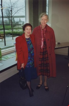
- Pixie McGeachie (left) and Florence Godwin, 1992. Item no. 330-003
- Length
- 0:09:07
- Interview Date
- January 10, 1973
- Scope and Content
- Recording is of a book reading given by Pixie McGeachie on January 10, 1973 to the Burnaby Historical Society from the book "Archdeacon on Horseback" by Canon Cyril E.H. Williams (then archivist in the Vancouver School of Theology, University of British Columbia) and Pixie McGeachie.
- Biographical Notes
- Doreen "Pixie" (Johnson) McGeachie was a resident of Burnaby for over sixty years. Pixie married John Aloysius "Jack" McGeachie and raised their children Kathi (Dunlop) and David McGeachie in the house the couple built themselves in 1947. Pixie served as the editor for the Burnaby Examiner newspaper and wrote a column entitled "Burnaby History" for The News. In 1974 she authored her first book titled "Bygones of Burnaby" which was one of the first to develop anecdotal stories about pioneer life in Burnaby. She authored "Burnaby - A Proud Century" in 1992 and in 2002 she wrote a biography of the city's namesake in the book "Land of Promise: Robert Burnaby's letters from Colonial B.C." She also contributed many hours of volunteering; helping to establish Burnaby's first museum Heritage Village in 1971, serving as President of the Burnaby Historical Society from 1991-1993. She served a six year term on Burnaby's Heritage Commission leading the charge to preserve many historic sites throughout the city, and during her twenty years as the Community Archives volunteer archivist for the historical society, she succeeded in gathering thousands of rare and valuable historic photographs and documents which now forms the core of the photograph collection on the Heritage Burnaby website (as these items were donated by the Society to the City Archives in 2007). The City of Burnaby awarded Pixie McGeachie the Kushiro Cup as Citizen of the year in 2002. In 2006 she received a Heritage BC project award for leading the Friends of Interurban 1223 project, and in 2008 Heritage BC recognised her again by presenting her with the Ruby Nobb Award. John Aloysius "Jack" McGeachie died October 12, 1981 at the age of sixty-seven. Doreen "Pixie" (Johnson) McGeachie died August 14, 2010 at the age of eighty-nine.
- Total Tracks
- 6
- Total Length
- 0:54:31
- Interviewee Name
- McGeachie, Doreen “Pixie”
- Collection/Fonds
- Burnaby Historical Society fonds
- Subseries
- Oral history subseries
- Media Type
- Sound Recording
- Web Notes
- Interview was digitized in 2010 allowing it to be accessible on Heritage Burnaby. The digitization project was initiated by the Community Heritage Commission with support from City of Burnaby Council and the BC History Digitization Program of the Irving K. Barber Learning Centre, University of British Columbia. It was recognized by the Heritage Society of BC with an award in 2012.
Images
Audio Tracks
Track five of recording of a book reading given by Pixie McGeachie
Track five of recording of a book reading given by Pixie McGeachie
https://search.heritageburnaby.ca/media/hpo/_Data/_Archives_Oral_Histories/_Unrestricted/MSS137-017-2/MSS137-017-2_Track_5.mp3
Book reading given by Pixie McGeachie January 10, 1973 - Track 6
https://search.heritageburnaby.ca/link/oralhistory242
- Repository
- City of Burnaby Archives
- Date Range
- 1872-1874
- Length
- 0:08:15
- Summary
- This portion of the recording pertains to Pixie McGeachie's continued reading of "Archdeacon on Horseback" by Canon Cyril E.H. Williams and herself. This section of the reading describes the mission at Lytton, British Columbia. An unidentified man speaks at the completion of the reading, giving som…
- Repository
- City of Burnaby Archives
- Summary
- This portion of the recording pertains to Pixie McGeachie's continued reading of "Archdeacon on Horseback" by Canon Cyril E.H. Williams and herself. This section of the reading describes the mission at Lytton, British Columbia. An unidentified man speaks at the completion of the reading, giving some details on various individuals discussed during the reading.
- Date Range
- 1872-1874
- Photo Info
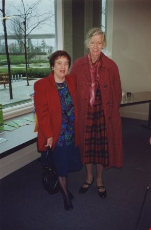
- Pixie McGeachie (left) and Florence Godwin, 1992. Item no. 330-003
- Length
- 0:08:15
- Subjects
- Buildings - Religious
- Interview Date
- January 10, 1973
- Scope and Content
- Recording is of a book reading given by Pixie McGeachie on January 10, 1973 to the Burnaby Historical Society from the book "Archdeacon on Horseback" by Canon Cyril E.H. Williams (then archivist in the Vancouver School of Theology, University of British Columbia) and Pixie McGeachie.
- Biographical Notes
- Doreen "Pixie" (Johnson) McGeachie was a resident of Burnaby for over sixty years. Pixie married John Aloysius "Jack" McGeachie and raised their children Kathi (Dunlop) and David McGeachie in the house the couple built themselves in 1947. Pixie served as the editor for the Burnaby Examiner newspaper and wrote a column entitled "Burnaby History" for The News. In 1974 she authored her first book titled "Bygones of Burnaby" which was one of the first to develop anecdotal stories about pioneer life in Burnaby. She authored "Burnaby - A Proud Century" in 1992 and in 2002 she wrote a biography of the city's namesake in the book "Land of Promise: Robert Burnaby's letters from Colonial B.C." She also contributed many hours of volunteering; helping to establish Burnaby's first museum Heritage Village in 1971, serving as President of the Burnaby Historical Society from 1991-1993. She served a six year term on Burnaby's Heritage Commission leading the charge to preserve many historic sites throughout the city, and during her twenty years as the Community Archives volunteer archivist for the historical society, she succeeded in gathering thousands of rare and valuable historic photographs and documents which now forms the core of the photograph collection on the Heritage Burnaby website (as these items were donated by the Society to the City Archives in 2007). The City of Burnaby awarded Pixie McGeachie the Kushiro Cup as Citizen of the year in 2002. In 2006 she received a Heritage BC project award for leading the Friends of Interurban 1223 project, and in 2008 Heritage BC recognised her again by presenting her with the Ruby Nobb Award. John Aloysius "Jack" McGeachie died October 12, 1981 at the age of sixty-seven. Doreen "Pixie" (Johnson) McGeachie died August 14, 2010 at the age of eighty-nine.
- Total Tracks
- 6
- Total Length
- 0:54:31
- Interviewee Name
- McGeachie, Doreen “Pixie”
- Collection/Fonds
- Burnaby Historical Society fonds
- Subseries
- Oral history subseries
- Media Type
- Sound Recording
- Web Notes
- Interview was digitized in 2010 allowing it to be accessible on Heritage Burnaby. The digitization project was initiated by the Community Heritage Commission with support from City of Burnaby Council and the BC History Digitization Program of the Irving K. Barber Learning Centre, University of British Columbia. It was recognized by the Heritage Society of BC with an award in 2012.
Images
Audio Tracks
Track six of recording of a book reading given by Pixie McGeachie
Track six of recording of a book reading given by Pixie McGeachie
https://search.heritageburnaby.ca/media/hpo/_Data/_Archives_Oral_Histories/_Unrestricted/MSS137-017-2/MSS137-017-2_Track_6.mp3
Chinese Herbalist Shops and TCM
https://search.heritageburnaby.ca/link/museumdescription14274
- Repository
- Burnaby Village Museum
- Date
- 2020
- Collection/Fonds
- Burnaby Village Museum fonds
- Description Level
- Item
- Physical Description
- 1 sound recording (mp3) (00:16:19 min)
- Scope and Content
- Item consists of a recording of part three in a series of three “Back to the Roots” podcasts where the hosts Rose Wu and Wei Yan Yeong, "Dig up the roots of the past to unearth the foundations of the Chinese Canadian experience in Burnaby." This episode three is titled "Chinese Herbalist Shops and …
- Repository
- Burnaby Village Museum
- Collection/Fonds
- Burnaby Village Museum fonds
- Series
- UBC Partnership series
- Description Level
- Item
- Physical Description
- 1 sound recording (mp3) (00:16:19 min)
- Material Details
- Podcasts hosts: Rose Wu; Wei Yan Yeong Persons from recorded extracts: Denise Fong; Josephine Chow; Julie Lee Guest: Dr. John Yang Podcast Date: October 2020 Total Number of tracks: 1 Total Length of all tracks: 00:16:19 min Photograph info: Store front of Way Sang Yuen Wat Kee & Co in Victoria, B.C., 1975. BV017.7.191
- Scope and Content
- Item consists of a recording of part three in a series of three “Back to the Roots” podcasts where the hosts Rose Wu and Wei Yan Yeong, "Dig up the roots of the past to unearth the foundations of the Chinese Canadian experience in Burnaby." This episode three is titled "Chinese Herbalist Shops and TCM". The podcasts were created by students Rose Wu and Wei Yan Yeong from the Faculty of Land and Food Systems at the University of British Columbia Faculty and while student interns at Burnaby Village Museum. In this series the students connect their knowledge of food systems to their shared Chinese heritage in order to discover how Chinese Canadian history is rooted in their local food systems. 00:00 - 01:34 Podcast opens with an introduction to this episode in the podcast series. 01:35 - 03:43 This portion of the podcast consists of segments of pre-recorded interviews between Denise Fong and Chinese-Canadians Julie Lee and Josephine Chow who grew up in Burnaby. Josephine and Jule recall visiting herbalist shops in Vancouver's Chinatown during the nineteen fifties and sixties. Due to the lack of herbalist shops in the Burnaby community during that time, it was common for a Chinese farming family to travel to Vancouver’s Chinatown in order to obtain herbal prescriptions or dried goods. Julie speaks briefly about what the type of Traditional Chinese medical care and advice her mother and family received. Josephine Chow tells of a female Chinese doctor from Vancouver, Madeline Chung who was responsible for delivering a lot of Chinese babies including Josephine and describes how her mother would take members of the family to the herbalist in Vancouver's Chinatown. 03:44 - 04:44 In this portion, the hosts tell of how aside from its medicinal purposes, herbalist shops also have a major socio-cultural significance to the Chinese community. The hosts describe the traditional layout of Chinese herblist shops, with a table set up for the game Ma Jong in the back and a seating area where customers could chat while waiting and be served tea. The hosts provide an example of the "Way Sang Yuen Wat Kee & Co." herbalist shop in Victoria that was open between 1905 and 1967 and of how the shop and contents are now part of a permanent exhibit at the Burnaby Village Museum. 04:45 - 09:21 In this portion, the hosts describe "Traditional Chinese Medicine" also known as "TCM". In order to better understand the importance of TCM in Chinese culture, and specifically to Chinese-Canadian immigrants, the hosts interview Dr John Yang, the chairperson and program director of Kwantlen Polytechnic University's TCM program. Holding a PHD in TCM before migrating with his family to Canada, Dr Yang came here 30 years ago and immediately started his journey as a TCM practitioner at his home basement in Burnaby. Dr. Yang tells of how he worked with the lobbying group, ATCMA (The British Columbia Association of Traditional Chinese Medicine and Acupuncture Practitioners) to help legitimize TCM as a recognized form of medical health care. In 1996, the Canadian government finally approved the legitimization of TCM in Canada, where one is required to take a licensing exam before they’re allowed to start their practices in Canada. 09:22 - 15:17 In this portion of the podcast, Dr. Yang and hosts describe how Traditional Chinese Medicine and treatments differ from Western medicine, how TCM is a way of life and regularly incorporated into recipes and diets, the lack of social acceptance and the import of Chinese medicinal herbs and misconceptions. 15:18 - 16:19 Conclusion, credits and acknowledgements.
- History
- Podcast hosts, Rose Wu and Wei Yan Yeong are University of British Columbia students in the Faculty of Land and Food Systems and student interns at Burnaby Village Museum.
- Creator
- Burnaby Village Museum
- Subjects
- Persons - Chinese Canadians
- Social Issues - Discrimination
- Social Issues - Racism
- Public Services - Health Services
- Names
- Lee, Julie Cho Chan
- Chow, Josephine
- Fong, Denise
- Yang, Dr. John
- Way Sang Yuen Wat Kee & Company
- Burnaby Village Museum
- Responsibility
- Wu, Rose
- Yeong, Wei Yan
- Accession Code
- BV020.28.5
- Access Restriction
- No restrictions
- Reproduction Restriction
- No known restrictions
- Date
- 2020
- Media Type
- Sound Recording
- Related Material
- BV020.28.3; BV020.28.4
- Notes
- Title based contents of sound recording
- See also Interview with Josephine Chow by Denise Fong February 7, 2020 - BV020.6.1; Interview with Julie Lee by Denise Fong February 6, 2020 - BV020.6.2
- For associated video recording of research interview with Dr. John Yang - see BV020.28.1
- Compilation of Research Resources used by authors Rose Wu and Wei Yan Yeong include:
- B.C. to recognize doctors of Chinese medicine: https://www.cbc.ca/news/canada/b-c-to-recognize-doctors-of-chinese-medicine-1.396806
- B.C. takes steps to legitimize traditional Chinese medicine: https://www.theglobeandmail.com/news/national/bc-takes-steps-to-legitimize-traditional-chinese-medicine/article18428851/
- Traditional Chinese medicine moves into the mainstream https://www.straight.com/life/415386/traditional-chinese-medicine-moves-mainstream
- Burnaby Village Museum - Interview with Josephine Chow by Denise Fong Feb. 7, 2020. BV020.6.1 https://search.heritageburnaby.ca/permalink/museumsoundrecording12337
- Burnaby Village Museum, Interview with Julie Lee by Denise Fong Feb. 6, 2020. BV020.6.2 https://search.heritageburnaby.ca/permalink/museumsoundrecording12338
Images

Audio Tracks
Chinese Herbalist Shops and TCM, 2020
Chinese Herbalist Shops and TCM, 2020
https://search.heritageburnaby.ca/media/hpo/_Data/_BVM_Sound_Recordings/Sound_Recordings/2020_0028_0005_001.mp3Cylinder records 1901-1919
https://search.heritageburnaby.ca/link/museumdescription13109
- Repository
- Burnaby Village Museum
- Date
- [1901-1919] (date of original content), April 1987 (date of recording), digitized in 2020
- Collection/Fonds
- Century Park Museum Association fonds
- Description Level
- Item
- Physical Description
- 1 audio cassette (28 min., 48 sec.)
- Scope and Content
- Audio recording titled "Cylinder Records 1901-1919". Recording consists of samples of music recorded from the Burnaby Village Museum cylinder record collection. This recording may have been used for an exhibit or as part of a public or school program.
- Repository
- Burnaby Village Museum
- Collection/Fonds
- Century Park Museum Association fonds
- Description Level
- Item
- Physical Description
- 1 audio cassette (28 min., 48 sec.)
- Material Details
- Track Number: 1 (side A of audio cassette)
- Total Number of Tracks : 1
- Scope and Content
- Audio recording titled "Cylinder Records 1901-1919". Recording consists of samples of music recorded from the Burnaby Village Museum cylinder record collection. This recording may have been used for an exhibit or as part of a public or school program.
- Creator
- Burnaby Village Museum
- Subjects
- Music
- Responsibility
- Burnaby Village Museum
- Accession Code
- BV020.5.729
- Access Restriction
- No restrictions
- Reproduction Restriction
- May be restricted by third party rights
- Date
- [1901-1919] (date of original content), April 1987 (date of recording), digitized in 2020
- Media Type
- Sound Recording
- Notes
- Title based on contents of sound recording
- Label on audio cassette reads: "Cylinder Records 1901-1919 / Recorded at BVM Apr 1987)
- Label on audio cassette case reads: "CYLINDER RECORDS 1901-1919"
Audio Tracks
Cylinder records 1901-1919, [1901-1919] (date of original content), April 1987 (date of recording), digitized in 2020
Cylinder records 1901-1919, [1901-1919] (date of original content), April 1987 (date of recording), digitized in 2020
https://search.heritageburnaby.ca/media/hpo/_Data/_BVM_Sound_Recordings/Oral_Histories/2020_0005_0729_001.mp3
Edmonds Street School site
https://search.heritageburnaby.ca/link/museumdescription11125
- Repository
- Burnaby Village Museum
- Date
- March 8, 1915
- Collection/Fonds
- Ronald G. Scobbie collection
- Description Level
- Item
- Physical Description
- 1 survey plan : blueprint on paper ; 56 x 54 cm
- Scope and Content
- Survey plan of "Edmonds Street School Site" "Burnaby Municipality" "Being Lots 28 and 29 of the Subdivision of Lot 30, Group 1, New Westminster District";
- Repository
- Burnaby Village Museum
- Collection/Fonds
- Ronald G. Scobbie collection
- Description Level
- Item
- Physical Description
- 1 survey plan : blueprint on paper ; 56 x 54 cm
- Material Details
- Scale: 4 feet = 1 inch
- Scope and Content
- Survey plan of "Edmonds Street School Site" "Burnaby Municipality" "Being Lots 28 and 29 of the Subdivision of Lot 30, Group 1, New Westminster District";
- Subjects
- Buildings - Schools
- Names
- Edmonds Community School
- Responsibility
- Burnett and McGugan B.C. Land Surveyors, New Westminster
- Geographic Access
- Edmonds Street
- Street Address
- 7641 Edmonds Street
- Accession Code
- BV003.83.5
- Access Restriction
- No restrictions
- Reproduction Restriction
- No known restrictions
- Date
- March 8, 1915
- Media Type
- Cartographic Material
- Historic Neighbourhood
- Edmonds (Historic Neighbourhood)
- Planning Study Area
- Edmonds Area
- Scan Resolution
- 440
- Scan Date
- 22-Dec-2020
- Scale
- 100
- Notes
- Title based on contents of plan
- Oath in bottom left corner reads: "I, D.J. McGugan...and did personally superintend the survey..." "...completed on the 8th day of March 1915"; signed "D.J. McGugan", notarized by "S.F. Mark" "sworn...12th Day of April 1915"
- handwritten on back, "1756"
Zoomable Images


Fire insurance key plan - Greater Vancouver - Volume XIX - Municipality of Burnaby
https://search.heritageburnaby.ca/link/museumdescription17799
- Repository
- Burnaby Village Museum
- Date
- 1927
- Collection/Fonds
- Burnaby Village Museum Map collection
- Description Level
- Item
- Physical Description
- 1 plan on 1 sheet : col. lithographic print ; 64 x 54 cm
- Scope and Content
- Item consists of a one page fire insurance key plan titled "Greater Vancouver / Volume XIX / Municipality / of Burnaby / Key Plan" surveyed May 1927. Key plan from compilation, "Insurance Plans of Greater Vancouver Plan No. 11, Volumes 15 to 19 Burnaby".
- Repository
- Burnaby Village Museum
- Collection/Fonds
- Burnaby Village Museum Map collection
- Description Level
- Item
- Physical Description
- 1 plan on 1 sheet : col. lithographic print ; 64 x 54 cm
- Material Details
- Scale [1:6000]
- Scope and Content
- Item consists of a one page fire insurance key plan titled "Greater Vancouver / Volume XIX / Municipality / of Burnaby / Key Plan" surveyed May 1927. Key plan from compilation, "Insurance Plans of Greater Vancouver Plan No. 11, Volumes 15 to 19 Burnaby".
- Publisher
- Plan Department of Fire Branch of British Columbia Underwriters' Association
- Accession Code
- BV987.1.70
- Access Restriction
- No restrictions
- Reproduction Restriction
- May be restricted by third party rights
- Date
- 1927
- Media Type
- Cartographic Material
- Historic Neighbourhood
- Fraser Arm (Historic Neighbourhood)
- Planning Study Area
- Big Bend Area
- Scan Resolution
- 400
- Scan Date
- 2021-11-17
- Notes
- Title based on contents of item
- Scale 500 feet = 1 inch
- These plans were removed from a bound book with labels on cover page reading: "Plan No. 90 / THIS INSURANCE PLAN / of / Vancouver VOLUME "8" / IN THE PROPERTY OF THE / British Columbia Insurance Underwriter's Association / Vancouver B.C. / AND IS LOANED / MELVILLE F. THOMSON CO. .../ Date May 26th, 1934"; / "Plan No. 74 / THIS INSURANCE PLAN / OF / VANCOUVER VOLUME "9"" / Plan No. 11 / THIS INSURANCE PLAN / OF / BURNABY VOLUMES 15-19" / "THIS PLAN IS THE PROPERTY OF / THE / BRITISH LAW INSURANCE COMPANY / LIMITED"
- Does not include the corresponding key plan page or associated plans numbered 1901 to 1914
- Contact Burnaby Village Museum to view associated fire insurance plans
Zoomable Images

Fire insurance key plan - Greater Vancouver - Volume XIX - Municipality of Burnaby, 1927
Zoom into Image
Fire insurance key plan - Greater Vancouver - Volume XVI - Municipality of Burnaby
https://search.heritageburnaby.ca/link/museumdescription17796
- Repository
- Burnaby Village Museum
- Date
- 1927
- Collection/Fonds
- Burnaby Village Museum Map collection
- Description Level
- Item
- Physical Description
- 2 plans on 2 sheets: col. lithographic print ; 64 x 54 cm
- Scope and Content
- Item consists of a two page fire insurance key plan titled "Greater Vancouver / Volume XVI / Municipality / of Burnaby / Key Plan" surveyed May 1927. Volume XVI includes a two page Key Plan (C and D). .
- Repository
- Burnaby Village Museum
- Collection/Fonds
- Burnaby Village Museum Map collection
- Description Level
- Item
- Physical Description
- 2 plans on 2 sheets: col. lithographic print ; 64 x 54 cm
- Scope and Content
- Item consists of a two page fire insurance key plan titled "Greater Vancouver / Volume XVI / Municipality / of Burnaby / Key Plan" surveyed May 1927. Volume XVI includes a two page Key Plan (C and D). .
- Publisher
- Plan Department of Fire Branch of British Columbia Underwriters Association
- Accession Code
- BV987.1.70
- Access Restriction
- No restrictions
- Reproduction Restriction
- May be restricted by third party rights
- Date
- 1927
- Media Type
- Cartographic Material
- Scan Resolution
- 400
- Scan Date
- 11/17/2021
- Notes
- Title based on contents of item
- Item "GREATER VANCOUVER / VOLUME XVI / MUNICIPALITY OF / BURNABY / KEY PLAN" does not include associated numbered plans (1601 to 1651)
- These plans were removed from a bound book with labels on cover page reading: "Plan No. 90 / THIS INSURANCE PLAN / of / Vancouver VOLUME "8" / IN THE PROPERTY OF THE / British Columbia Insurance Underwriter's Association / Vancouver B.C. / AND IS LOANED / MELVILLE F. THOMSON CO. .../ Date May 26th, 1934"; / "Plan No. 74 / THIS INSURANCE PLAN / OF / VANCOUVER VOLUME "9"" / Plan No. 11 / THIS INSURANCE PLAN / OF / BURNABY VOLUMES 15-19" / "THIS PLAN IS THE PROPERTY OF / THE / BRITISH LAW INSURANCE COMPANY / LIMITED"
Zoomable Images

Fire insurance key plan - Greater Vancouver - Volume XVI - Municipality of Burnaby, 1927
Zoom into Image

Gilmour Avenue School site
https://search.heritageburnaby.ca/link/museumdescription11129
- Repository
- Burnaby Village Museum
- Date
- May 27, 1915
- Collection/Fonds
- Ronald G. Scobbie collection
- Description Level
- Item
- Physical Description
- 1 survey plan : blueprint on paper ; 56 x 54 cm
- Scope and Content
- Survey plan of Gilmore Avenue School site. Title on plan reads: "Gilmour Avenue School Site / Burnaby Municipality / Being Lots 1-10 inc. & Lots 27-36 inc. of Block 9 / of Subdivision of a Portion of Lot 187, GP.1 / New Westminster District". "Note. School site is as shown below, the original...am…
- Repository
- Burnaby Village Museum
- Collection/Fonds
- Ronald G. Scobbie collection
- Description Level
- Item
- Physical Description
- 1 survey plan : blueprint on paper ; 56 x 54 cm
- Material Details
- Scale: 40 feet = 1 inch
- Scope and Content
- Survey plan of Gilmore Avenue School site. Title on plan reads: "Gilmour Avenue School Site / Burnaby Municipality / Being Lots 1-10 inc. & Lots 27-36 inc. of Block 9 / of Subdivision of a Portion of Lot 187, GP.1 / New Westminster District". "Note. School site is as shown below, the original...amended" "by cancelling Lots 1-10 & 27-30 inc....order of court filed No.4938".
- History
- The school was named after Hugh B. Gilmour, but an error by a municipal clerk in the Street Naming Bylaw in 1912 (Bylaw Number 135) changed the spelling to "Gilmore" Avenue and the school name was spelled "Gilmore" Avenue School hereafter.
- Creator
- McGugan, Donald Johnston
- Subjects
- Buildings - Schools
- Names
- Gilmore Avenue School
- Responsibility
- Burnett & McGugan, Engineers and Surveyors
- Geographic Access
- Gilmore Avenue
- Accession Code
- BV003.83.8
- Access Restriction
- No restrictions
- Reproduction Restriction
- No known restrictions
- Date
- May 27, 1915
- Media Type
- Cartographic Material
- Historic Neighbourhood
- Vancouver Heights (Historic Neighbourhood)
- Planning Study Area
- Willingdon Heights Area
- Scan Resolution
- 440
- Scan Date
- 22-Dec-2020
- Scale
- 100
- Notes
- Transcribed title taken from plan
- Oath in bottom left corner reads: "I, D.J. McGugan...did superintend the survey", "...completed on the 27th day of May 1915" and noterized by Walter Edmonds" "sworn...29th Day of May 1915"; "Burnett and McGugan. B.C. Land Surveyors Etc. New Westminster. B.C."
- Note in black ink on verso of plan reads: "1782"
Zoomable Images

![Highways map of British Columbia, Alberta and adjacent states, [1930] thumbnail](/media/hpo/_Data/_BVM_Cartographic_Material/1977/1977_0037_0187_001.jpg?width=280)
Highways map of British Columbia, Alberta and adjacent states
https://search.heritageburnaby.ca/link/museumdescription9668
- Repository
- Burnaby Village Museum
- Date
- [1930]
- Collection/Fonds
- Burnaby Village Museum Map collection
- Description Level
- Item
- Physical Description
- 1 map : col. lithographic print ; both sides ; 89.5 x 58 cm, folded to 11.5 x 20 cm
- Scope and Content
- Double sided road map published by Imperial Oil, Ltd. and featuring the main travelled highway routes of British Columbia, Alberta and the Northwestern-most states of the United States of America. The map is a colour lithograph. The main map is green, with the highways highlighted in red. The litho…
- Repository
- Burnaby Village Museum
- Collection/Fonds
- Burnaby Village Museum Map collection
- Description Level
- Item
- Physical Description
- 1 map : col. lithographic print ; both sides ; 89.5 x 58 cm, folded to 11.5 x 20 cm
- Material Details
- Scale 1 inch = 20 miles
- A.R. THOMSON / CHIEF CARTOGRAPHER
- Scope and Content
- Double sided road map published by Imperial Oil, Ltd. and featuring the main travelled highway routes of British Columbia, Alberta and the Northwestern-most states of the United States of America. The map is a colour lithograph. The main map is green, with the highways highlighted in red. The lithograph was created in Canada by Rolph Clark Stone Ltd in Toronto. The opposite side of the map features inset maps of the following: the Trans-Canada Highway, the highway between Prince Rupert and Prince George, the highway through the Canadian Rockies, and the highway through the Peace River District. Small city plan maps of highways through major cities, as well as advertisements for Imperial Oil products, are also found on the opposite side of the main map. This map is one of four produced by Imperial Oil that covered the most populated areas of Canada from coast to coast and paralleled Imperial Oil's distribution service.
- Creator
- Thomson, A.R.
- Publisher
- Imperial Oil Limited
- Accession Code
- HV977.37.187
- Access Restriction
- No restrictions
- Reproduction Restriction
- No known restrictions
- Date
- [1930]
- Media Type
- Cartographic Material
- Scan Resolution
- 600
- Scan Date
- 2023-11-10
- Notes
- Title based on content of map
Zoomable Images
![Highways map of British Columbia, Alberta and adjacent states, [1930] thumbnail](/media/hpo/_Data/_BVM_Cartographic_Material/1977/1977_0037_0187_003_seadragon/1977_0037_0187_003.jpg?w=280)


Howard Avenue School site
https://search.heritageburnaby.ca/link/museumdescription11124
- Repository
- Burnaby Village Museum
- Date
- March 24, 1915
- Collection/Fonds
- Ronald G. Scobbie collection
- Description Level
- Item
- Physical Description
- 1 survey plan : blueprint on paper ; 56 x 54 cm
- Scope and Content
- Survey plan of "Howard Avenue School Site" "Burnaby Municipality", "Being Lots 1-5 and 14-18 Inc. Block 5 of the Subd. of Easterly 3/4 of Lot 127. Group 1, New Westminster District";
- Repository
- Burnaby Village Museum
- Collection/Fonds
- Ronald G. Scobbie collection
- Description Level
- Item
- Physical Description
- 1 survey plan : blueprint on paper ; 56 x 54 cm
- Material Details
- Scale: 40 feet = 1 inch
- Scope and Content
- Survey plan of "Howard Avenue School Site" "Burnaby Municipality", "Being Lots 1-5 and 14-18 Inc. Block 5 of the Subd. of Easterly 3/4 of Lot 127. Group 1, New Westminster District";
- Creator
- McGugan, Donald Johnston
- Subjects
- Buildings - Schools
- Names
- Howard Avenue School
- Responsibility
- Burnett and McGugan B.C. Land Surveyors, New Westminster
- Geographic Access
- Howard Avenue
- Georgia Street
- Accession Code
- BV003.83.4
- Access Restriction
- No restrictions
- Reproduction Restriction
- No known restrictions
- Date
- March 24, 1915
- Media Type
- Cartographic Material
- Historic Neighbourhood
- Capitol Hill (Historic Neighbourhood)
- Planning Study Area
- Capitol Hill Area
- Scan Resolution
- 440
- Scan Date
- 22-Dec-2020
- Scale
- 100
- Notes
- Title based on contents of plan
- Oath in bottom left corner reads: "I, D.J. McGugan...and did personally superintend the survey..." "...completed on the 24th day of March 1915"; signed "D.J. McGugan", notarized on April 12th, 1915 by "R. Chapman"
- handwritten on back, "1754"
Zoomable Images

![Indexed guide map of the City of Vancouver and suburbs, [1920] thumbnail](/media/hpo/_Data/_BVM_Cartographic_Material/1975/1975_0061_0013_001.jpg?width=280)
Indexed guide map of the City of Vancouver and suburbs
https://search.heritageburnaby.ca/link/museumdescription8678
- Repository
- Burnaby Village Museum
- Date
- [1920]
- Collection/Fonds
- Burnaby Village Museum Map collection
- Description Level
- Item
- Physical Description
- 1 map + textual record : col. lithographic print on paper ; 51.5 x 71 cm folded to 21 x 10 cm
- Scope and Content
- Item consists of a fold out map entitled "Indexed Guide Map of Vancouver and Suburbs" with index. Map includes concentric circles raditating out from Vancouver City Hall on corner of Hastings Street and Main Street; electric railways are indicated by heavy red lines in centres of streets. Includes …
- Repository
- Burnaby Village Museum
- Collection/Fonds
- Burnaby Village Museum Map collection
- Description Level
- Item
- Physical Description
- 1 map + textual record : col. lithographic print on paper ; 51.5 x 71 cm folded to 21 x 10 cm
- Material Details
- Scale [1:47520]
- Index on 4 pages within cardstock cover with advertisements on verso
- Scope and Content
- Item consists of a fold out map entitled "Indexed Guide Map of Vancouver and Suburbs" with index. Map includes concentric circles raditating out from Vancouver City Hall on corner of Hastings Street and Main Street; electric railways are indicated by heavy red lines in centres of streets. Includes old and new street names. Index includes a District Lot Index and Street Index.
- Publisher
- Vancouver Map and Blue Print Company
- Accession Code
- HV975.61.13
- Access Restriction
- No restrictions
- Reproduction Restriction
- No known restrictions
- Date
- [1920]
- Media Type
- Cartographic Material
- Textual Record
- Publisher Series
- 6th edition revised June 1920
- Scan Resolution
- 600
- Scan Date
- 2023-11-10
- Notes
- Title based on contents of map
- Cover of booklet reads: "INDEXED / Guide Map / of the CITY of / VANCOUVER / and / SUBURBS / Compiled and Published by / The Vancouver Map & Blue Print Co. / ...."INTERNATIONAL / BOOK SHOP / Cor. Columbia and Hastings Sts._Vancouver, B.C.".
Documents
Zoomable Images
![Indexed guide map of the City of Vancouver and suburbs, [1920] thumbnail](/media/hpo/_Data/_BVM_Cartographic_Material/1975/1975_0061_0013_002_seadragon/1975_0061_0013_002.jpg?w=280)

Indexed guide map of the city of Vancouver and Suburbs
https://search.heritageburnaby.ca/link/museumdescription8694
- Repository
- Burnaby Village Museum
- Date
- 1914
- Collection/Fonds
- Burnaby Village Museum Map collection
- Description Level
- Item
- Physical Description
- 1 map + textual record : col. lithographic print on paper ; 55 x 78 cm on sheet 58.5 x 82 cm folded to 20 x 10 cm
- Scope and Content
- Item consists of a map "Indexed Guide Map of the City of Vancouver and Suburbs compiled and published by The Vancouver Map and Blueprint Co. Ltd. Map shows district lots, blocks and boundaries between City of Vancouver, Point Grey, South Vancouver, Burnaby, New Westminster and parts of Richmond, No…
- Repository
- Burnaby Village Museum
- Collection/Fonds
- Burnaby Village Museum Map collection
- Description Level
- Item
- Physical Description
- 1 map + textual record : col. lithographic print on paper ; 55 x 78 cm on sheet 58.5 x 82 cm folded to 20 x 10 cm
- Material Details
- Scale not defined
- Map is folded into booklet form
- Scope and Content
- Item consists of a map "Indexed Guide Map of the City of Vancouver and Suburbs compiled and published by The Vancouver Map and Blueprint Co. Ltd. Map shows district lots, blocks and boundaries between City of Vancouver, Point Grey, South Vancouver, Burnaby, New Westminster and parts of Richmond, North Vancouver and West Vancouver. Concentric cirlces indicate the distance in miles from the intersection of Main Street and Hastings Street, Vancouver in intervals of 1/2 mile. Map is folded into booklet form and includes a four page index with cardstock cover. Index page 1 is titled "Hotels"; page 2 is titled "District Lot Index"; pages 3-8 "Street Index".
- Publisher
- Vancouver Map and Blueprint Company Limited
- Edition
- 5th Edition revised to June 1914
- Geographic Access
- Vancouver
- Accession Code
- HV983.9.18
- Date
- 1914
- Media Type
- Cartographic Material
- Scan Resolution
- 600
- Scan Date
- 2023-08-17
- Notes
- Transcribed title from map and cover
- Sticker adhered to front cover of index of two lions "Service / "WE GIVE IT" / WESTERN SPECIALTY / LIMITED/ STATIONERS AND PRINTERS / VANCOUVER - B.C."
Documents
Zoomable Images

![Indexed map of Greater Vancouver, [193-] thumbnail](/media/hpo/_Data/_BVM_Cartographic_Material/1976/1976_0026_0001_001.jpg?width=280)
Indexed map of Greater Vancouver
https://search.heritageburnaby.ca/link/museumdescription8201
- Repository
- Burnaby Village Museum
- Date
- [193-]
- Collection/Fonds
- Burnaby Village Museum Map collection
- Description Level
- Item
- Physical Description
- 1 map + 1 p. textual records : b&w lithographic print on 1 sheet ; 46 x 41 cm folded to 23 x 10 cm
- Scope and Content
- Item consists of a promotional brochure for Bekins Moving and Storage, with an indexed map of Greater Vancouver showing distances from the Bekins building located at Pender Street and Beatty Street on one side, and text and images advertising the company's services and facilities on the other side.…
- Repository
- Burnaby Village Museum
- Collection/Fonds
- Burnaby Village Museum Map collection
- Description Level
- Item
- Physical Description
- 1 map + 1 p. textual records : b&w lithographic print on 1 sheet ; 46 x 41 cm folded to 23 x 10 cm
- Material Details
- Scale not defined
- Printing on two sides of sheet
- Folded into eight sections
- Scope and Content
- Item consists of a promotional brochure for Bekins Moving and Storage, with an indexed map of Greater Vancouver showing distances from the Bekins building located at Pender Street and Beatty Street on one side, and text and images advertising the company's services and facilities on the other side. Cover of folded map reads "Indexed Map of Greater Vancouver / The Great Northwest for Opportunity / Compliments of / Bekins Moving and / Storage Co.".
- Responsibility
- Bekins Moving and Storage Company Limited
- Accession Code
- HV976.26.1
- Access Restriction
- No restrictions
- Reproduction Restriction
- No known restrictions
- Date
- [193-]
- Media Type
- Cartographic Material
- Textual Record
- Scan Resolution
- 600
- Scan Date
- 2023-08-17
- Notes
- Title based on contents of map
Zoomable Images
![Indexed map of Greater Vancouver, [193-] thumbnail](/media/hpo/_Data/_BVM_Cartographic_Material/1976/1976_0026_0001_001_seadragon/1976_0026_0001_001.jpg?w=280)

Inman Avenue School site
https://search.heritageburnaby.ca/link/museumdescription11128
- Repository
- Burnaby Village Museum
- Date
- May 3, 1915
- Collection/Fonds
- Ronald G. Scobbie collection
- Description Level
- Item
- Physical Description
- 1 survey plan : blueprint on paper ; 56 x 54 cm
- Scope and Content
- Survey plan of "Inman Avenue School Site" "Burnaby Municipality" "Being Lots 3 -12 inc. Blk. C. of Subd. of Blks.5" "13-19 inc. & 21-28 inc. of Subd. of Westerly 80 Acres of, and portion of D.L. 34, Group One. New Westminster District".
- Repository
- Burnaby Village Museum
- Collection/Fonds
- Ronald G. Scobbie collection
- Description Level
- Item
- Physical Description
- 1 survey plan : blueprint on paper ; 56 x 54 cm
- Material Details
- Scale: 40 feet = 1 inch
- Scope and Content
- Survey plan of "Inman Avenue School Site" "Burnaby Municipality" "Being Lots 3 -12 inc. Blk. C. of Subd. of Blks.5" "13-19 inc. & 21-28 inc. of Subd. of Westerly 80 Acres of, and portion of D.L. 34, Group One. New Westminster District".
- Creator
- McGugan, Donald Johnston
- Subjects
- Buildings - Schools
- Names
- Inman Avenue School
- Responsibility
- Burnett & McGugan, Engineers and Surveyors
- Geographic Access
- Brandon Street
- Street Address
- 3963 Brandon Street
- Accession Code
- BV003.83.7
- Access Restriction
- No restrictions
- Reproduction Restriction
- No known restrictions
- Date
- May 3, 1915
- Media Type
- Cartographic Material
- Historic Neighbourhood
- Central Park (Historic Neighbourhood)
- Planning Study Area
- Garden Village Area
- Scan Resolution
- 440
- Scan Date
- 22-Dec-2020
- Scale
- 100
- Notes
- Title based on contents of plan
- Oath in bottom left corner reads: "I, D.J. McGugan...did...superintend the survey...", "...completed on the 3rd day of May 1915"; signed "D.J. McGugan", notariz- ed by "Walter Edmonds" "sworn...22nd Day of May 1915"; "Burnett and McGugan. B.C. Land Surveyors. Etc. New Westminster. B.C.";
- handwritten note reads: "Note: Before using this Mon. see plan / of resubdivision of Lots 5 & 6 / of Block 'B' D.L. 34 / June 1945"
- handwritten twice on back, "1776"
Zoomable Images

![Aili Rintanen (later Topalian) holding cat, next to her sister who has a rooster in her arms, [1937]. Item no. 337-003. thumbnail](/media/hpo/_Data/_Archives_Images/_Unrestricted/316/337-003.jpg?width=280)
Interview with Aili Topalian by Eric Damer October 11, 2012 - Track 1
https://search.heritageburnaby.ca/link/oralhistory419
- Repository
- City of Burnaby Archives
- Date Range
- 1920-1945
- Length
- 0:10:12
- Summary
- This portion of the recording pertains mainly to Aili (Rintanen) Topalian's parents. Aili tells the story of her parents meeting, getting married and eventually setting in Crabtown with their two children. She explains what it was like to live in Crabtown during the depression years; the homes were…
- Repository
- City of Burnaby Archives
- Summary
- This portion of the recording pertains mainly to Aili (Rintanen) Topalian's parents. Aili tells the story of her parents meeting, getting married and eventually setting in Crabtown with their two children. She explains what it was like to live in Crabtown during the depression years; the homes were built on decks which were on top of pilings, that were sunk deep into the sand.
- Date Range
- 1920-1945
- Photo Info
- Aili Rintanen (later Topalian) holding cat, next to her sister who has a rooster in her arms, [1937]. Item no. 337-003.
- Length
- 0:10:12
- Geographic Access
- Burrard Inlet
- Historic Neighbourhood
- Vancouver Heights (Historic Neighbourhood)
- Interviewer
- Damer, Eric
- Interview Date
- October 11, 2012
- Scope and Content
- Recording is an interview with Aili (Rintanen) Topalian conducted by Burnaby Village Museum employee Eric Damer, October 11, 2012. Major theme discussed: growing up in Crabtown.
- Biographical Notes
- Aili Rintanen (later Topalian) came to British Columbia in 1936 from a homestead near Burnt Lake, Alberta. After a few months in Vancouver and then a Burnaby apartment, the Rintanens moved to a house on the Burrard Inlet. The family lived over the water, in a house built on a deck, secured to the top of pilings that were sunk deep into the sand. Aili's mother Aune Rintanen found work at a fish and chip shop in downtown Vancouver and her father Gus Rintanen worked in a nearby mill. Aili and her sister Trudi (later Tuomi), attended school in Burnaby. For nine years the Rintanens created a home for themselves in an area now called Crabtown, although no one living there called it that.
- Total Tracks
- 4
- Total Length
- 0:39:00
- Interviewee Name
- Topalian, Aili Rintanen
- Interview Location
- Interviewee's residence
- Interviewer Bio
- Eric Damer is a lifelong British Columbian born in Victoria, raised in Kamloops, and currently residing in Burnaby. After studying philosophy at the University of Victoria, he became interested in the educational forces that had shaped his own life. He completed master’s and doctoral degrees in educational studies at the University of British Columbia with a particular interest in the history of adult and higher education in the province. In 2012, Eric worked for the City of Burnaby as a field researcher and writer, conducting interviews for the City Archives and Museum Oral History Program.
- Collection/Fonds
- Community Heritage Commission Special Projects fonds
- Transcript Available
- None
- Media Type
- Sound Recording
Images
![Aili Rintanen (later Topalian) holding cat, next to her sister who has a rooster in her arms, [1937]. Item no. 337-003. thumbnail](/media/hpo/_Data/_Archives_Images/_Unrestricted/316/337-003.jpg)
Audio Tracks
Track one of recording of interview with Aili Topalian
Track one of recording of interview with Aili Topalian
https://search.heritageburnaby.ca/media/hpo/_Data/_Archives_Oral_Histories/_Unrestricted/MSS171-028/MSS171-028_Track_1.mp3
Interview with Aili Topalian by Eric Damer October 11, 2012 - Track 2
https://search.heritageburnaby.ca/link/oralhistory420
- Repository
- City of Burnaby Archives
- Date Range
- 1920-1945
- Length
- 0:07:49
- Summary
- This portion of the recording pertains to Aili (Rintanen) Topalian's collection of photographs. Aili describes each photograph and tells stories of her childhood along the waterfront at Burrard Inlet; the homes of Crabtown were built on decks which were on top of pilings, that were sunk deep into t…
- Repository
- City of Burnaby Archives
- Summary
- This portion of the recording pertains to Aili (Rintanen) Topalian's collection of photographs. Aili describes each photograph and tells stories of her childhood along the waterfront at Burrard Inlet; the homes of Crabtown were built on decks which were on top of pilings, that were sunk deep into the sand.
- Date Range
- 1920-1945
- Photo Info
- Aili Rintanen (later Topalian) holding cat, next to her sister who has a rooster in her arms, [1937]. Item no. 337-003.
- Length
- 0:07:49
- Geographic Access
- Burrard Inlet
- Historic Neighbourhood
- Vancouver Heights (Historic Neighbourhood)
- Interviewer
- Damer, Eric
- Interview Date
- October 11, 2012
- Scope and Content
- Recording is an interview with Aili (Rintanen) Topalian conducted by Burnaby Village Museum employee Eric Damer, October 11, 2012. Major theme discussed: growing up in Crabtown.
- Biographical Notes
- Aili Rintanen (later Topalian) came to British Columbia in 1936 from a homestead near Burnt Lake, Alberta. After a few months in Vancouver and then a Burnaby apartment, the Rintanens moved to a house on the Burrard Inlet. The family lived over the water, in a house built on a deck, secured to the top of pilings that were sunk deep into the sand. Aili's mother Aune Rintanen found work at a fish and chip shop in downtown Vancouver and her father Gus Rintanen worked in a nearby mill. Aili and her sister Trudi (later Tuomi), attended school in Burnaby. For nine years the Rintanens created a home for themselves in an area now called Crabtown, although no one living there called it that.
- Total Tracks
- 4
- Total Length
- 0:39:00
- Interviewee Name
- Topalian, Aili Rintanen
- Interview Location
- Interviewee's residence
- Interviewer Bio
- Eric Damer is a lifelong British Columbian born in Victoria, raised in Kamloops, and currently residing in Burnaby. After studying philosophy at the University of Victoria, he became interested in the educational forces that had shaped his own life. He completed master’s and doctoral degrees in educational studies at the University of British Columbia with a particular interest in the history of adult and higher education in the province. In 2012, Eric worked for the City of Burnaby as a field researcher and writer, conducting interviews for the City Archives and Museum Oral History Program.
- Collection/Fonds
- Community Heritage Commission Special Projects fonds
- Transcript Available
- None
- Media Type
- Sound Recording
Images
Audio Tracks
Track two of recording of interview with Aili Topalian
Track two of recording of interview with Aili Topalian
https://search.heritageburnaby.ca/media/hpo/_Data/_Archives_Oral_Histories/_Unrestricted/MSS171-028/MSS171-028_Track_2.mp3
Interview with Aili Topalian by Eric Damer October 11, 2012 - Track 3
https://search.heritageburnaby.ca/link/oralhistory421
- Repository
- City of Burnaby Archives
- Date Range
- 1937-1949
- Length
- 0:10:42
- Summary
- This portion of the recording pertains to Aili (Rintanen) Topalian's childhood along the waterfront at Burrard Inlet (the homes of Crabtown were built on decks which were on top of pilings, that were sunk deep into the sand). Aili describes her childhood neighbours, her family home, family friends,…
- Repository
- City of Burnaby Archives
- Summary
- This portion of the recording pertains to Aili (Rintanen) Topalian's childhood along the waterfront at Burrard Inlet (the homes of Crabtown were built on decks which were on top of pilings, that were sunk deep into the sand). Aili describes her childhood neighbours, her family home, family friends, dance halls, and the Marine Building in Vancouver.
- Date Range
- 1937-1949
- Photo Info
- Aili Rintanen (later Topalian) holding cat, next to her sister who has a rooster in her arms, [1937]. Item no. 337-003.
- Length
- 0:10:42
- Geographic Access
- Burrard Inlet
- Historic Neighbourhood
- Vancouver Heights (Historic Neighbourhood)
- Interviewer
- Damer, Eric
- Interview Date
- October 11, 2012
- Scope and Content
- Recording is an interview with Aili (Rintanen) Topalian conducted by Burnaby Village Museum employee Eric Damer, October 11, 2012. Major theme discussed: growing up in Crabtown.
- Biographical Notes
- Aili Rintanen (later Topalian) came to British Columbia in 1936 from a homestead near Burnt Lake, Alberta. After a few months in Vancouver and then a Burnaby apartment, the Rintanens moved to a house on the Burrard Inlet. The family lived over the water, in a house built on a deck, secured to the top of pilings that were sunk deep into the sand. Aili's mother Aune Rintanen found work at a fish and chip shop in downtown Vancouver and her father Gus Rintanen worked in a nearby mill. Aili and her sister Trudi (later Tuomi), attended school in Burnaby. For nine years the Rintanens created a home for themselves in an area now called Crabtown, although no one living there called it that.
- Total Tracks
- 4
- Total Length
- 0:39:00
- Interviewee Name
- Topalian, Aili Rintanen
- Interview Location
- Interviewee's residence
- Interviewer Bio
- Eric Damer is a lifelong British Columbian born in Victoria, raised in Kamloops, and currently residing in Burnaby. After studying philosophy at the University of Victoria, he became interested in the educational forces that had shaped his own life. He completed master’s and doctoral degrees in educational studies at the University of British Columbia with a particular interest in the history of adult and higher education in the province. In 2012, Eric worked for the City of Burnaby as a field researcher and writer, conducting interviews for the City Archives and Museum Oral History Program.
- Collection/Fonds
- Community Heritage Commission Special Projects fonds
- Transcript Available
- None
- Media Type
- Sound Recording
Images
Audio Tracks
Track three of recording of interview with Aili Topalian
Track three of recording of interview with Aili Topalian
https://search.heritageburnaby.ca/media/hpo/_Data/_Archives_Oral_Histories/_Unrestricted/MSS171-028/MSS171-028_Track_3.mp3
Interview with Aili Topalian by Eric Damer October 11, 2012 - Track 4
https://search.heritageburnaby.ca/link/oralhistory422
- Repository
- City of Burnaby Archives
- Date Range
- 1937-1979
- Length
- 0:10:15
- Summary
- This portion of the recording pertains to Aili (Rintanen) Topalian's memories of her early life in Burnaby. Aili discusses family friends, Maplewood flats in North Vancovuer, the waterfront at Burrard Inlet, owning Bantam Roosters and an Alsatian dog. She mentions some of the more challenging aspec…
- Repository
- City of Burnaby Archives
- Summary
- This portion of the recording pertains to Aili (Rintanen) Topalian's memories of her early life in Burnaby. Aili discusses family friends, Maplewood flats in North Vancovuer, the waterfront at Burrard Inlet, owning Bantam Roosters and an Alsatian dog. She mentions some of the more challenging aspects of Crabtown.
- Date Range
- 1937-1979
- Photo Info
- Aili Rintanen (later Topalian) holding cat, next to her sister who has a rooster in her arms, [1937]. Item no. 337-003.
- Length
- 0:10:15
- Geographic Access
- Burrard Inlet
- Historic Neighbourhood
- Vancouver Heights (Historic Neighbourhood)
- Interviewer
- Damer, Eric
- Interview Date
- October 11, 2012
- Scope and Content
- Recording is an interview with Aili (Rintanen) Topalian conducted by Burnaby Village Museum employee Eric Damer, October 11, 2012. Major theme discussed: growing up in Crabtown.
- Biographical Notes
- Aili Rintanen (later Topalian) came to British Columbia in 1936 from a homestead near Burnt Lake, Alberta. After a few months in Vancouver and then a Burnaby apartment, the Rintanens moved to a house on the Burrard Inlet. The family lived over the water, in a house built on a deck, secured to the top of pilings that were sunk deep into the sand. Aili's mother Aune Rintanen found work at a fish and chip shop in downtown Vancouver and her father Gus Rintanen worked in a nearby mill. Aili and her sister Trudi (later Tuomi), attended school in Burnaby. For nine years the Rintanens created a home for themselves in an area now called Crabtown, although no one living there called it that.
- Total Tracks
- 4
- Total Length
- 0:39:00
- Interviewee Name
- Topalian, Aili Rintanen
- Interview Location
- Interviewee's residence
- Interviewer Bio
- Eric Damer is a lifelong British Columbian born in Victoria, raised in Kamloops, and currently residing in Burnaby. After studying philosophy at the University of Victoria, he became interested in the educational forces that had shaped his own life. He completed master’s and doctoral degrees in educational studies at the University of British Columbia with a particular interest in the history of adult and higher education in the province. In 2012, Eric worked for the City of Burnaby as a field researcher and writer, conducting interviews for the City Archives and Museum Oral History Program.
- Collection/Fonds
- Community Heritage Commission Special Projects fonds
- Transcript Available
- None
- Media Type
- Sound Recording
Images
Audio Tracks
Track four of recording of interview with Aili Topalian
Track four of recording of interview with Aili Topalian
https://search.heritageburnaby.ca/media/hpo/_Data/_Archives_Oral_Histories/_Unrestricted/MSS171-028/MSS171-028_Track_4.mp3Interview with Alekxos Sarter by Kathy Bossort October 16, 2015 - Track 1
https://search.heritageburnaby.ca/link/oralhistory577
- Repository
- City of Burnaby Archives
- Date Range
- 1980-2015
- Length
- 0:12:40
- Summary
- This portion of the interview is about Alekxos Sarter’s overview of her education and her career with City of Burnaby Parks, Recreation and Cultural Services beginning in 1986. She tells a delightful story about Prince Charles and Princess Diana at the opening ceremony of the Variety Playground in …
- Repository
- City of Burnaby Archives
- Summary
- This portion of the interview is about Alekxos Sarter’s overview of her education and her career with City of Burnaby Parks, Recreation and Cultural Services beginning in 1986. She tells a delightful story about Prince Charles and Princess Diana at the opening ceremony of the Variety Playground in Central Park.
- Date Range
- 1980-2015
- Length
- 0:12:40
- Subjects
- Education
- Occupations
- Events - Royal Visits
- Interviewer
- Bossort, Kathy
- Interview Date
- October 16, 2015
- Scope and Content
- Recording is of an interview with Alekxos Sarter conducted by Kathy Bossort. Alekxos Sarter was one of 23 participants interviewed as part of the Community Heritage Commission’s Burnaby Mountain Oral History Project. The interview is mainly about the history of setting aside parkland on Burnaby Mountain from Alekxos Sarter’s perspective and experience as employee in the City of Burnaby Parks, Recreation and Cultural Services. The interview provides an excellent explanation of the history and function of kinds of park dedications used by the City of Burnaby; an overview of issues around including the Trans Mountain tank farm in the conservation area; and the background to the land use and ownership disagreement between the City of Burnaby and Simon Fraser University, its resolution, and the subsequent development of SFU’s UniverCity. Alekxos Sarter talks about Richard Bolton, Burnaby’s Acting-Commissioner who was responsible for dedicating the first park on Burnaby Mountain in 1942, and the creation of a park named after him in UniverCity.
- Biographical Notes
- Alekxos Sarter was born in Vancouver in 1961, to Daine and Kasandra Sarter. She grew up in North Vancouver and since 1994 has lived on a sailboat in False Creek. After attending UBC where she studied landscape architecture, she was hired by the City of Burnaby Parks, Recreation and Cultural Services in 1986. Working first in parks design, Alekxos quickly moved into parks planning, her preferred career. As Research Officer she covers research, planning, public consultation, parks and facility inventory, parkland acquisition, among other duties.
- Total Tracks
- 9
- Total Length
- 2:20:47
- Interviewee Name
- Sarter, Alekxos T.
- Interview Location
- City of Burnaby Parks, Recreation and Cultural Services meeting room
- Interviewer Bio
- Kathy Bossort is a retired archivist living in Ladner, BC. She worked at the Delta Museum and Archives after graduating from SLAIS (UBC) in 2001 with Masters degrees in library science and archival studies. Kathy grew up in Calgary, Alberta, and, prior to this career change, she lived in the West Kootenays, earning her living as a cook for BC tourist lodges and work camps. She continues to be interested in oral histories as a way to fill the gaps in the written record and bring richer meaning to history.
- Collection/Fonds
- Community Heritage Commission Special Projects fonds
- Media Type
- Sound Recording
Audio Tracks
Track one of interview with Alekxos Sarter
Track one of interview with Alekxos Sarter
https://search.heritageburnaby.ca/media/hpo/_Data/_Archives_Oral_Histories/_Unrestricted/MSS196-005/MSS196-005_Track_1.mp3Interview with Alekxos Sarter by Kathy Bossort October 16, 2015 - Track 2
https://search.heritageburnaby.ca/link/oralhistory578
- Repository
- City of Burnaby Archives
- Date Range
- 1958-1992
- Length
- 0:12:40
- Summary
- This portion of the interview is about Alekxos Sarter’s first years of employment with Parks, her sources of knowledge about Burnaby Mountain, and the department’s activities in Burnaby Mountain Park. She talks about the loop trail planned for Burnaby Mountain Park in 1958, the Trans Canada Trail p…
- Repository
- City of Burnaby Archives
- Summary
- This portion of the interview is about Alekxos Sarter’s first years of employment with Parks, her sources of knowledge about Burnaby Mountain, and the department’s activities in Burnaby Mountain Park. She talks about the loop trail planned for Burnaby Mountain Park in 1958, the Trans Canada Trail project, events and issues at the Pavilion, and keeping track of trails on SFU lands.
- Date Range
- 1958-1992
- Length
- 0:12:40
- Names
- Burnaby Parks, Recreation and Cultural Services Department
- Burnaby Mountain Park
- Kamui Mintara
- Trans Canada Trail
- Geographic Access
- Burnaby Mountain Conservation Area
- Interviewer
- Bossort, Kathy
- Interview Date
- October 16, 2015
- Scope and Content
- Recording is of an interview with Alekxos Sarter conducted by Kathy Bossort. Alekxos Sarter was one of 23 participants interviewed as part of the Community Heritage Commission’s Burnaby Mountain Oral History Project. The interview is mainly about the history of setting aside parkland on Burnaby Mountain from Alekxos Sarter’s perspective and experience as employee in the City of Burnaby Parks, Recreation and Cultural Services. The interview provides an excellent explanation of the history and function of kinds of park dedications used by the City of Burnaby; an overview of issues around including the Trans Mountain tank farm in the conservation area; and the background to the land use and ownership disagreement between the City of Burnaby and Simon Fraser University, its resolution, and the subsequent development of SFU’s UniverCity. Alekxos Sarter talks about Richard Bolton, Burnaby’s Acting-Commissioner who was responsible for dedicating the first park on Burnaby Mountain in 1942, and the creation of a park named after him in UniverCity.
- Biographical Notes
- Alekxos Sarter was born in Vancouver in 1961, to Daine and Kasandra Sarter. She grew up in North Vancouver and since 1994 has lived on a sailboat in False Creek. After attending UBC where she studied landscape architecture, she was hired by the City of Burnaby Parks, Recreation and Cultural Services in 1986. Working first in parks design, Alekxos quickly moved into parks planning, her preferred career. As Research Officer she covers research, planning, public consultation, parks and facility inventory, parkland acquisition, among other duties.
- Total Tracks
- 9
- Total Length
- 2:20:47
- Interviewee Name
- Sarter, Alekxos T.
- Interview Location
- City of Burnaby Parks, Recreation and Cultural Services meeting room
- Interviewer Bio
- Kathy Bossort is a retired archivist living in Ladner, BC. She worked at the Delta Museum and Archives after graduating from SLAIS (UBC) in 2001 with Masters degrees in library science and archival studies. Kathy grew up in Calgary, Alberta, and, prior to this career change, she lived in the West Kootenays, earning her living as a cook for BC tourist lodges and work camps. She continues to be interested in oral histories as a way to fill the gaps in the written record and bring richer meaning to history.
- Collection/Fonds
- Community Heritage Commission Special Projects fonds
- Media Type
- Sound Recording
Audio Tracks
Track two of interview with Alekxos Sarter
Track two of interview with Alekxos Sarter
https://search.heritageburnaby.ca/media/hpo/_Data/_Archives_Oral_Histories/_Unrestricted/MSS196-005/MSS196-005_Track_2.mp3