Narrow Results By
Subject
- Accidents 15
- Accidents - Automobile Accidents 30
- Accidents - Train Accidents 23
- Adminstrative Groups - Committees 4
- Adornment - Jewelry 7
- Adornment - Lapel Pins 1
- Advertising Medium 11
- Advertising Medium - Flyer 3
- Advertising Medium - Poster 16
- Advertising Medium - Signs and Signboards 221
- Aerial Photographs 132
- Agricultural Tools and Equipment 24
Creator
- A. A. Marks (firm) 1
- Abbott, George Knapp, 1880-1959 1
- Abbott, Jacob, 1803-1879 1
- Abraham, Dorothy, 1894- 1
- Ackerknecht, Erwin H. (Erwin Heinz), 1906-1988 1
- Action Line Housing Society 1
- Adams, Albert Egerton 1
- Adams, Beth 1
- Adams, Beverley 1
- Adams, Edith 2
- Adams, George Burton, 1851-1925 1
- Adams, Gladstone 1

1982 - Moving the Roberts House
https://search.heritageburnaby.ca/link/archivedescription91888
- Repository
- City of Burnaby Archives
- Date
- September 1982
- Collection/Fonds
- Small family fonds
- Description Level
- Item
- Physical Description
- 1 photograph : col. ; 9 cm x 13 cm
- Scope and Content
- Photograph of the Roberts' house in its new position at 5496 Dominion Street. Perimeter "pony" walls and other interior supporting walls were built to support the house. All of the plumbing and electrical wiring were replaced.
- Repository
- City of Burnaby Archives
- Date
- September 1982
- Collection/Fonds
- Small family fonds
- Physical Description
- 1 photograph : col. ; 9 cm x 13 cm
- Description Level
- Item
- Record No.
- 620-069
- Access Restriction
- No restrictions
- Reproduction Restriction
- No reproduction permitted
- Accession Number
- 2017-01
- Scope and Content
- Photograph of the Roberts' house in its new position at 5496 Dominion Street. Perimeter "pony" walls and other interior supporting walls were built to support the house. All of the plumbing and electrical wiring were replaced.
- Media Type
- Photograph
- Notes
- Transcribed title
- Title transcribed from donor's notes
- Note in blue ink on verso of photograph reads: "B5 P11"
- Note in pencil on verso of photograph reads: "10"
- Note in black ink on verso of photograph reads: "Sept. 82"
- Street Address
- 5496 Dominion Street
- Historic Neighbourhood
- Burnaby Lake (Historic Neighbourhood)
- Planning Study Area
- Ardingley-Sprott Area
Images


1982 - Moving the Roberts House
https://search.heritageburnaby.ca/link/archivedescription91889
- Repository
- City of Burnaby Archives
- Date
- September 1982
- Collection/Fonds
- Small family fonds
- Description Level
- Item
- Physical Description
- 1 photograph : col. ; 9 cm x 13 cm
- Scope and Content
- Photograph of the Roberts' house in its new position at 5496 Dominion Street with an additional "cold storage" room added beneath the front porch and windows installed.
- Repository
- City of Burnaby Archives
- Date
- September 1982
- Collection/Fonds
- Small family fonds
- Physical Description
- 1 photograph : col. ; 9 cm x 13 cm
- Description Level
- Item
- Record No.
- 620-070
- Access Restriction
- No restrictions
- Reproduction Restriction
- No reproduction permitted
- Accession Number
- 2017-01
- Scope and Content
- Photograph of the Roberts' house in its new position at 5496 Dominion Street with an additional "cold storage" room added beneath the front porch and windows installed.
- Media Type
- Photograph
- Notes
- Transcribed title
- Title transcribed from donor's notes
- Note in blue ink on verso of photograph reads: "B10 P12"
- Note in pencil on verso of photograph reads: "11"
- Note in black ink on verso of photograph reads: "Sept. 82"
- Street Address
- 5496 Dominion Street
- Historic Neighbourhood
- Burnaby Lake (Historic Neighbourhood)
- Planning Study Area
- Ardingley-Sprott Area
Images


1982 - Moving the Roberts House
https://search.heritageburnaby.ca/link/archivedescription91890
- Repository
- City of Burnaby Archives
- Date
- November 1982
- Collection/Fonds
- Small family fonds
- Description Level
- Item
- Physical Description
- 1 photograph : col. ; 9 cm x 13 cm
- Scope and Content
- Photograph of the Roberts' house in its new position at 5496 Dominion Street. Cedar siding was added to finish the exterior, the original white pillars were re-installed on the front porch, the house was stained, and basic landscaping was completed.
- Repository
- City of Burnaby Archives
- Date
- November 1982
- Collection/Fonds
- Small family fonds
- Physical Description
- 1 photograph : col. ; 9 cm x 13 cm
- Description Level
- Item
- Record No.
- 620-071
- Access Restriction
- No restrictions
- Reproduction Restriction
- No reproduction permitted
- Accession Number
- 2017-01
- Scope and Content
- Photograph of the Roberts' house in its new position at 5496 Dominion Street. Cedar siding was added to finish the exterior, the original white pillars were re-installed on the front porch, the house was stained, and basic landscaping was completed.
- Media Type
- Photograph
- Notes
- Transcribed title
- Title transcribed from donor's notes
- Note in blue ink on verso of photograph reads: "B19 P13"
- Note in pencil on verso of photograph reads: "12"
- Note in black ink on verso of photograph reads: "Front Steps Now! and A New Staining Job. / Nov. 1982"
- Street Address
- 5496 Dominion Street
- Historic Neighbourhood
- Burnaby Lake (Historic Neighbourhood)
- Planning Study Area
- Ardingley-Sprott Area
Images


1982 - Moving the Roberts House
https://search.heritageburnaby.ca/link/archivedescription91891
- Repository
- City of Burnaby Archives
- Date
- 1982
- Collection/Fonds
- Small family fonds
- Description Level
- Item
- Physical Description
- 1 photograph : col. ; 10 cm x 15 cm
- Scope and Content
- Photograph of an excavator clearing the land between 5496 Dominion Street and Douglas Road. The three lots in this area were subdivided into six 33 foot lots and cleared for the construction of six new houses.
- Repository
- City of Burnaby Archives
- Date
- 1982
- Collection/Fonds
- Small family fonds
- Physical Description
- 1 photograph : col. ; 10 cm x 15 cm
- Description Level
- Item
- Record No.
- 620-072
- Access Restriction
- No restrictions
- Reproduction Restriction
- No reproduction permitted
- Accession Number
- 2017-01
- Scope and Content
- Photograph of an excavator clearing the land between 5496 Dominion Street and Douglas Road. The three lots in this area were subdivided into six 33 foot lots and cleared for the construction of six new houses.
- Media Type
- Photograph
- Notes
- Transcribed title
- Title transcribed from donor's notes
- Note in blue ink on verso of photograph reads: "P.14"
- Note in pencil on verso of photograph reads: "13"
- Street Address
- 5496 Dominion Street
- Historic Neighbourhood
- Burnaby Lake (Historic Neighbourhood)
- Planning Study Area
- Ardingley-Sprott Area
Images


1982 - Moving the Roberts House
https://search.heritageburnaby.ca/link/archivedescription91892
- Repository
- City of Burnaby Archives
- Date
- 1982
- Collection/Fonds
- Small family fonds
- Description Level
- Item
- Physical Description
- 1 photograph : col. ; 15 cm x 10 cm
- Scope and Content
- Photograph of a labourer removing the old foundation and boulders from the 5496 Dominion Street property with a jackhammer. The house located at 5511 Norfolk Street is visible in the background.
- Repository
- City of Burnaby Archives
- Date
- 1982
- Collection/Fonds
- Small family fonds
- Physical Description
- 1 photograph : col. ; 15 cm x 10 cm
- Description Level
- Item
- Record No.
- 620-073
- Access Restriction
- No restrictions
- Reproduction Restriction
- No reproduction permitted
- Accession Number
- 2017-01
- Scope and Content
- Photograph of a labourer removing the old foundation and boulders from the 5496 Dominion Street property with a jackhammer. The house located at 5511 Norfolk Street is visible in the background.
- Media Type
- Photograph
- Notes
- Transcribed title
- Title transcribed from donor's notes
- Note in blue ink on verso of photograph reads: "P.15"
- Note in pencil on verso of photograph reads: "14"
- 5511 Norfolk Street was previously numbered 3149 Norfolk Street. It was later subdivided into two lots: 5503 and 5521 Norfolk Street.
- Street Address
- 5511 Norfolk Street
- 5496 Dominion Street
- Historic Neighbourhood
- Burnaby Lake (Historic Neighbourhood)
- Planning Study Area
- Ardingley-Sprott Area
Images


1982 - Moving the Roberts House
https://search.heritageburnaby.ca/link/archivedescription91893
- Repository
- City of Burnaby Archives
- Date
- 1982 (date of original), copied 2017
- Collection/Fonds
- Small family fonds
- Description Level
- Item
- Physical Description
- 1 photograph : col. copy print ; 10 cm x 15 cm
- Scope and Content
- Photograph of new houses being constructed on the 33 foot lots between 5496 Dominion Street and Douglas Road. Framing is complete and the houses' roofs and windows are installed.
- Repository
- City of Burnaby Archives
- Date
- 1982 (date of original), copied 2017
- Collection/Fonds
- Small family fonds
- Physical Description
- 1 photograph : col. copy print ; 10 cm x 15 cm
- Description Level
- Item
- Record No.
- 620-074
- Access Restriction
- No restrictions
- Reproduction Restriction
- No reproduction permitted
- Accession Number
- 2017-01
- Scope and Content
- Photograph of new houses being constructed on the 33 foot lots between 5496 Dominion Street and Douglas Road. Framing is complete and the houses' roofs and windows are installed.
- Media Type
- Photograph
- Notes
- Transcribed title
- Title transcribed from donor's notes
- Note in blue ink on verso of photograph reads: "P.16"
- Geographic Access
- Dominion Street
- Street Address
- 5496 Dominion Street
- Historic Neighbourhood
- Burnaby Lake (Historic Neighbourhood)
- Planning Study Area
- Ardingley-Sprott Area
Images


1982 - Moving the Roberts House
https://search.heritageburnaby.ca/link/archivedescription91894
- Repository
- City of Burnaby Archives
- Date
- 2015
- Collection/Fonds
- Small family fonds
- Description Level
- Item
- Physical Description
- 1 photograph : col. copy print ; 10 cm x 15 cm
- Scope and Content
- Photograph of the "Roberts House" in its new location at 5496 Dominion Street.
- Repository
- City of Burnaby Archives
- Date
- 2015
- Collection/Fonds
- Small family fonds
- Physical Description
- 1 photograph : col. copy print ; 10 cm x 15 cm
- Description Level
- Item
- Record No.
- 620-075
- Access Restriction
- No restrictions
- Reproduction Restriction
- No reproduction permitted
- Accession Number
- 2017-01
- Scope and Content
- Photograph of the "Roberts House" in its new location at 5496 Dominion Street.
- Subjects
- Buildings - Residential - Houses
- Media Type
- Photograph
- Notes
- Transcribed title
- Title transcribed from donor's notes
- Note in blue ink on verso of photograph reads: "P.17"
- Street Address
- 5496 Dominion Street
- Historic Neighbourhood
- Burnaby Lake (Historic Neighbourhood)
- Planning Study Area
- Ardingley-Sprott Area
Images


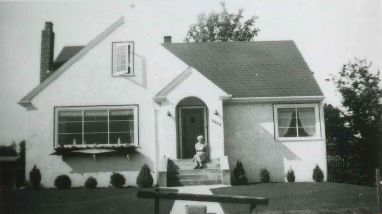
1982 - Moving the Roberts House 5538 Dominion Street to its new location at 5496 Dominion Street
https://search.heritageburnaby.ca/link/archivedescription91879
- Repository
- City of Burnaby Archives
- Date
- 1982
- Collection/Fonds
- Small family fonds
- Description Level
- Item
- Physical Description
- 1 photograph : col. ; 9 cm x 13 cm
- Scope and Content
- Photograph of the site at 5496 Dominion Street where the Roberts' house was to be moved. To the left is the old garage that was originally part of the small dwelling the Roberts lived in during the construction of their house in the early 1920s. In the background is 3093 Douglas Road and in the f…
- Repository
- City of Burnaby Archives
- Date
- 1982
- Collection/Fonds
- Small family fonds
- Physical Description
- 1 photograph : col. ; 9 cm x 13 cm
- Description Level
- Item
- Record No.
- 620-060
- Access Restriction
- No restrictions
- Reproduction Restriction
- No reproduction permitted
- Accession Number
- 2017-01
- Scope and Content
- Photograph of the site at 5496 Dominion Street where the Roberts' house was to be moved. To the left is the old garage that was originally part of the small dwelling the Roberts lived in during the construction of their house in the early 1920s. In the background is 3093 Douglas Road and in the foreground are two apple trees planted by John W. Roberts.
- Media Type
- Photograph
- Notes
- Transcribed title
- Title transcribed from donor's notes
- Note in blue ink on verso of photograph reads: "p.2"
- Note in blue ink on verso of photograph reads: "Garage, Poplar Tree and Apple Trees before they had to go to make room to move house here / Spring 1982"
- 5118 Douglas Road renumbered to 3131 Douglas Road in 1958 and to 5538 Dominion Street in 1970 or 1971
- Street Address
- 5496 Dominion Street
- Historic Neighbourhood
- Burnaby Lake (Historic Neighbourhood)
- Planning Study Area
- Ardingley-Sprott Area
Images

2000 useful facts about food : labor, time and money-saving hints, advice and suggestions
https://search.heritageburnaby.ca/link/museumlibrary5521
- Repository
- Burnaby Village Museum
- Collection
- Special Collection
- Material Type
- Book
- Accession Code
- BV002.65.9
- Call Number
- 641 BER
- Contributor
- Gaul, Edna L.
- et al.
- Place of Publication
- Chicago, Ill.
- Publisher
- Consolidated Book Publishers
- Publication Date
- 1952
- Physical Description
- 48 p. : ill. (some col.) ; 22 cm.
- Library Subject (LOC)
- Food
- Cooking
- Culinary Arts Institute
- Cookbooks--1950-1959
- Notes
- Includes index.
- "Culinary Arts Institute : One of America's foremost organizations devoted to the science of Better Cookery"
- Berolzheimer, Ruth (edited by)
![2002 Pacific Alliance Gymnastics Championships, [2002] thumbnail](/media/hpo/_Data/_Archives_Images/_Unrestricted/535/535-2347.jpg?width=280)
2002 Pacific Alliance Gymnastics Championships
https://search.heritageburnaby.ca/link/archivedescription96748
- Repository
- City of Burnaby Archives
- Date
- [2002]
- Collection/Fonds
- Burnaby NewsLeader photograph collection
- Description Level
- Item
- Physical Description
- 1 photograph (tiff) : col.
- Scope and Content
- Photograph of DJ Bucher competing on the rings during the Still Rings Junior Men's competition at the 2002 Pacific Alliance Gymnastics Championships at Copeland Arena.
- Repository
- City of Burnaby Archives
- Date
- [2002]
- Collection/Fonds
- Burnaby NewsLeader photograph collection
- Physical Description
- 1 photograph (tiff) : col.
- Description Level
- Item
- Record No.
- 535-2347
- Access Restriction
- No restrictions
- Reproduction Restriction
- No restrictions
- Accession Number
- 2018-12
- Scope and Content
- Photograph of DJ Bucher competing on the rings during the Still Rings Junior Men's competition at the 2002 Pacific Alliance Gymnastics Championships at Copeland Arena.
- Subjects
- Sports - Gymnastics
- Media Type
- Photograph
- Photographer
- Bartel, Mario
- Notes
- Title based on caption
- Collected by editorial for use in a May 2002 issue of the Burnaby NewsLeader
- Caption from metadata: "DJ Bucher, of the United States, competes in the Still Rings Junior Mens competition at the 2002 Pacific Alliance Gymnastics Championships, at Burnaby's Copeland Arena."
- Geographic Access
- Burnaby Lake Sports Complex
- Kensington Avenue
- Street Address
- 3676 Kensington Avenue
- Historic Neighbourhood
- Burnaby Lake (Historic Neighbourhood)
- Planning Study Area
- Ardingley-Sprott Area
Images
![2002 Pacific Alliance Gymnastics Championships, [2002] thumbnail](/media/hpo/_Data/_Archives_Images/_Unrestricted/535/535-2347.jpg)
![2003 Western Regional Festival of Synchronized Skating, [2003] thumbnail](/media/hpo/_Data/_Archives_Images/_Unrestricted/535/535-2038-1.jpg?width=280)
2003 Western Regional Festival of Synchronized Skating
https://search.heritageburnaby.ca/link/archivedescription96357
- Repository
- City of Burnaby Archives
- Date
- [2003]
- Collection/Fonds
- Burnaby NewsLeader photograph collection
- Description Level
- File
- Physical Description
- 2 photographs (tiff) : col.
- Scope and Content
- File contains photographs of the 2003 Western Regional Festival of Synchronized Skating at the Copeland Sports Centre. Photographs depict Ice Entice, of the Edmonton Synchronized Skating Club, and the Royal Blades, of the Wild Rose Figure Skating Club, skating in formations during the competition.
- Repository
- City of Burnaby Archives
- Date
- [2003]
- Collection/Fonds
- Burnaby NewsLeader photograph collection
- Physical Description
- 2 photographs (tiff) : col.
- Description Level
- File
- Record No.
- 535-2038
- Access Restriction
- No restrictions
- Reproduction Restriction
- No restrictions
- Accession Number
- 2018-12
- Scope and Content
- File contains photographs of the 2003 Western Regional Festival of Synchronized Skating at the Copeland Sports Centre. Photographs depict Ice Entice, of the Edmonton Synchronized Skating Club, and the Royal Blades, of the Wild Rose Figure Skating Club, skating in formations during the competition.
- Subjects
- Sports - Skating
- Media Type
- Photograph
- Photographer
- Bartel, Mario
- Notes
- Title based on caption
- Collected by editorial for use in a February 2003 issue of the Burnaby NewsLeader
- Caption from metadata for 535-2038-1: "Ice Entice, from the Edmonton Synchronized Skating Club, weave an intricate pattern in the Festival Adult competition at the 2003 Western Regional Festival of Synchronized Skating at Copeland Sports Centre."
- Caption from metadata for 535-2038-2: "The Royal Blades, from the Wild Rose Figure Skating Club, form a circle in the Festival Adult competition at the 2003 Western Regional Festival of Synchronized Skating, at Burnaby's Copeland Sports Centre."
- Geographic Access
- Burnaby Lake Sports Complex
- Kensington Avenue
- Street Address
- 3676 Kensington Avenue
- Historic Neighbourhood
- Burnaby Lake (Historic Neighbourhood)
- Planning Study Area
- Ardingley-Sprott Area
Images
![2003 Western Regional Festival of Synchronized Skating, [2003] thumbnail](/media/hpo/_Data/_Archives_Images/_Unrestricted/535/535-2038-1.jpg)
![2004 National STARSkate Championships, [2004] thumbnail](/media/hpo/_Data/_Archives_Images/_Unrestricted/535/535-2090-1.jpg?width=280)
2004 National STARSkate Championships
https://search.heritageburnaby.ca/link/archivedescription96420
- Repository
- City of Burnaby Archives
- Date
- [2004]
- Collection/Fonds
- Burnaby NewsLeader photograph collection
- Description Level
- File
- Physical Description
- 2 photographs (tiff) : col.
- Scope and Content
- File contains photographs of the Silver Triathalon Ladies' Free Skate at the 2004 National STARSkate Championships at Copeland Arena. Photographs depict figure skaters Kayla Berst and Brittany Baril performing their routines during the competition.
- Repository
- City of Burnaby Archives
- Date
- [2004]
- Collection/Fonds
- Burnaby NewsLeader photograph collection
- Physical Description
- 2 photographs (tiff) : col.
- Description Level
- File
- Record No.
- 535-2090
- Access Restriction
- No restrictions
- Reproduction Restriction
- No restrictions
- Accession Number
- 2018-12
- Scope and Content
- File contains photographs of the Silver Triathalon Ladies' Free Skate at the 2004 National STARSkate Championships at Copeland Arena. Photographs depict figure skaters Kayla Berst and Brittany Baril performing their routines during the competition.
- Subjects
- Sports - Skating
- Persons - Athletes
- Media Type
- Photograph
- Photographer
- Bartel, Mario
- Notes
- Title based on caption
- Collected by editorial for use in a March 2004 issue of the Burnaby NewsLeader
- Caption from metadata for 535-2090-1: "Kayla Berst, of the Northern Ontario section, carves a turn in the Silver Triathalon Ladies' Free Skate, at the 2004 National STARSkate Championships, Saturday at Copeland Arena. Almost 200 figure skaters from across Canada participated in the national competition."
- Caption from metadata for 535-2090-2: "Brittany Baril, of the Newfoundland section, completes a spin in the Silver Triathalon Ladies' Free Skate, at the 2004 National STARSkate Championships, Saturday at Copeland Arena. Almost 200 skaters from across Canada participated in the national competition."
- Geographic Access
- Burnaby Lake Sports Complex
- Kensington Avenue
- Street Address
- 3676 Kensington Avenue
- Historic Neighbourhood
- Burnaby Lake (Historic Neighbourhood)
- Planning Study Area
- Ardingley-Sprott Area
Images
![2004 National STARSkate Championships, [2004] thumbnail](/media/hpo/_Data/_Archives_Images/_Unrestricted/535/535-2090-1.jpg)

2007 Advisory Planning Commission portrait
https://search.heritageburnaby.ca/link/archivedescription90391
- Repository
- City of Burnaby Archives
- Date
- 2007
- Collection/Fonds
- City Council and Office of the City Clerk fonds
- Description Level
- Item
- Physical Description
- 1 photograph : col. ; 12.5 x 19 cm
- Scope and Content
- Photograph of the 2007 Advisory Planning Commission. Commission members left to right are: Rana Dhatt, Joanne Tseng, Tony Coccia, David Pereira, Gurmukh Bhogal, and Kwangyoung Conn. Photograph is a studio portrait.
- Repository
- City of Burnaby Archives
- Date
- 2007
- Collection/Fonds
- City Council and Office of the City Clerk fonds
- Series
- Council Committee series
- Subseries
- Advisory Planning Commission subseries
- Physical Description
- 1 photograph : col. ; 12.5 x 19 cm
- Description Level
- Item
- Record No.
- 527-002
- Reproduction Restriction
- No restrictions
- Accession Number
- 2011-07
- Scope and Content
- Photograph of the 2007 Advisory Planning Commission. Commission members left to right are: Rana Dhatt, Joanne Tseng, Tony Coccia, David Pereira, Gurmukh Bhogal, and Kwangyoung Conn. Photograph is a studio portrait.
- Subjects
- Documentary Artifacts - Portraits
- Officials - Alderman and Councillors
- Officials - Commissioners
- Media Type
- Photograph
- Notes
- Title based on contents of photograph
Images

![2009 World Police and Fire Games sponsorship announcement, [2005] thumbnail](/media/hpo/_Data/_Archives_Images/_Unrestricted/535/535-2172-2.jpg?width=280)
2009 World Police and Fire Games sponsorship announcement
https://search.heritageburnaby.ca/link/archivedescription96550
- Repository
- City of Burnaby Archives
- Date
- [2005]
- Collection/Fonds
- Burnaby NewsLeader photograph collection
- Description Level
- File
- Physical Description
- 2 photographs (tiff) : col.
- Scope and Content
- File contains photographs from the announcement of sponsorship for the 2009 World Police and Fire Games in Burnaby at the Copeland Arena. Photographs depict an unidentified RCMP officer during a moment of silence, with the John Robson Elementary School choir in the background, and unidentified fire…
- Repository
- City of Burnaby Archives
- Date
- [2005]
- Collection/Fonds
- Burnaby NewsLeader photograph collection
- Physical Description
- 2 photographs (tiff) : col.
- Description Level
- File
- Record No.
- 535-2172
- Access Restriction
- No restrictions
- Reproduction Restriction
- No restrictions
- Accession Number
- 2018-12
- Scope and Content
- File contains photographs from the announcement of sponsorship for the 2009 World Police and Fire Games in Burnaby at the Copeland Arena. Photographs depict an unidentified RCMP officer during a moment of silence, with the John Robson Elementary School choir in the background, and unidentified fire fighters demonstrating a rope rug-of-war event.
- Media Type
- Photograph
- Photographer
- Bartel, Mario
- Notes
- Title based on caption
- Collected by editorial for use in a March 2005 issue of the Burnaby NewsLeader
- Caption from metadata for 535-2172-1: "A member of the RCMP and the John Robson Elementary School choir pay silent tribute to four RCMP officers who were killed in Alberta, prior to the announcement of sponsorship for the World Police and Fire Games, Tuesday at Copeland Arena."
- Caption from metadata for 535-2172-2: "Burnaby firefighters demonstrate the tug-of-war, one of the events that comprise the firefighters' muster, a sports that will be featured at the 2009 World Police and Fire Games."
- Geographic Access
- Burnaby Lake Sports Complex
- Kensington Avenue
- Street Address
- 3676 Kensington Avenue
- Historic Neighbourhood
- Burnaby Lake (Historic Neighbourhood)
- Planning Study Area
- Ardingley-Sprott Area
Images
![2009 World Police and Fire Games sponsorship announcement, [2005] thumbnail](/media/hpo/_Data/_Archives_Images/_Unrestricted/535/535-2172-2.jpg)
2040-2074 Alpha Ave
https://search.heritageburnaby.ca/link/archivedescription93883
- Repository
- City of Burnaby Archives
- Date
- March 8, 1993
- Collection/Fonds
- Grover, Elliott & Co. Ltd. fonds
- Description Level
- File
- Physical Description
- 26 photographs : col. negatives ; 35 mm
- Scope and Content
- Photographs of the commercial buildings located at 2040-2074 Alpha Avenue. Stores visible in the photographs include E.B. Horsman and Bellevue.
- Repository
- City of Burnaby Archives
- Date
- March 8, 1993
- Collection/Fonds
- Grover, Elliott & Co. Ltd. fonds
- Physical Description
- 26 photographs : col. negatives ; 35 mm
- Description Level
- File
- Record No.
- 622-066
- Access Restriction
- No restrictions
- Reproduction Restriction
- No restrictions
- Accession Number
- 2017-39
- Scope and Content
- Photographs of the commercial buildings located at 2040-2074 Alpha Avenue. Stores visible in the photographs include E.B. Horsman and Bellevue.
- Media Type
- Photograph
- Notes
- Transcribed title
- Title transcribed from envelope photographs were originally housed in
- File no. 93-103-B
- Geographic Access
- Alpha Avenue
- Planning Study Area
- Dawson-Delta Area
![2224 Antrim Avenue, [1940] (date of original), copied 1991 thumbnail](/media/hpo/_Data/_Archives_Images/_Unrestricted/370/370-602.jpg?width=280)
2224 Antrim Avenue
https://search.heritageburnaby.ca/link/archivedescription38015
- Repository
- City of Burnaby Archives
- Date
- [1940] (date of original), copied 1991
- Collection/Fonds
- Burnaby Historical Society fonds
- Description Level
- Item
- Physical Description
- 1 photograph : b&w ; 2.3 x 3.2 cm print on contact sheet 20.6 x 26.9 cm
- Scope and Content
- Photograph of the side of the house at 2224 Antrim Avenue (later renumbered 6957 Antrim Avenue).
- Repository
- City of Burnaby Archives
- Date
- [1940] (date of original), copied 1991
- Collection/Fonds
- Burnaby Historical Society fonds
- Subseries
- Burnaby Image Bank subseries
- Physical Description
- 1 photograph : b&w ; 2.3 x 3.2 cm print on contact sheet 20.6 x 26.9 cm
- Description Level
- Item
- Record No.
- 370-602
- Access Restriction
- No restrictions
- Reproduction Restriction
- No known restrictions
- Accession Number
- BHS1999-03
- Scope and Content
- Photograph of the side of the house at 2224 Antrim Avenue (later renumbered 6957 Antrim Avenue).
- Media Type
- Photograph
- Notes
- Title based on contents of photograph
- 1 b&w copy negative accompanying
- Negative has a pink cast
- Geographic Access
- Antrim Avenue
- Street Address
- 6957 Antrim Avenue
- Historic Neighbourhood
- Central Park (Historic Neighbourhood)
- Planning Study Area
- Windsor Area
Images
![2224 Antrim Avenue, [1940] (date of original), copied 1991 thumbnail](/media/hpo/_Data/_Archives_Images/_Unrestricted/370/370-602.jpg)
![2224 Antrim Avenue, [1940] (date of original), copied 1991 thumbnail](/media/hpo/_Data/_Archives_Images/_Unrestricted/370/370-603.jpg?width=280)
2224 Antrim Avenue
https://search.heritageburnaby.ca/link/archivedescription38016
- Repository
- City of Burnaby Archives
- Date
- [1940] (date of original), copied 1991
- Collection/Fonds
- Burnaby Historical Society fonds
- Description Level
- Item
- Physical Description
- 1 photograph : b&w ; 2.7 x 4.6 cm print on contact sheet 20.6 x 26.9 cm
- Scope and Content
- Photograph of the backyard of 2224 Antrim Avenue (later renumbered 6957 Antrim Avenue). A woman is standing in the yard.
- Repository
- City of Burnaby Archives
- Date
- [1940] (date of original), copied 1991
- Collection/Fonds
- Burnaby Historical Society fonds
- Subseries
- Burnaby Image Bank subseries
- Physical Description
- 1 photograph : b&w ; 2.7 x 4.6 cm print on contact sheet 20.6 x 26.9 cm
- Description Level
- Item
- Record No.
- 370-603
- Access Restriction
- No restrictions
- Reproduction Restriction
- No known restrictions
- Accession Number
- BHS1999-03
- Scope and Content
- Photograph of the backyard of 2224 Antrim Avenue (later renumbered 6957 Antrim Avenue). A woman is standing in the yard.
- Subjects
- Buildings - Residential - Houses
- Media Type
- Photograph
- Notes
- Title based on contents of photograph
- 1 b&w copy negative accompanying
- Negative has a pink cast
- Geographic Access
- Antrim Avenue
- Street Address
- 6957 Antrim Avenue
- Historic Neighbourhood
- Central Park (Historic Neighbourhood)
- Planning Study Area
- Windsor Area
Images
![2224 Antrim Avenue, [1940] (date of original), copied 1991 thumbnail](/media/hpo/_Data/_Archives_Images/_Unrestricted/370/370-603.jpg)
2238 South Gilmore Ave
https://search.heritageburnaby.ca/link/archivedescription94329
- Repository
- City of Burnaby Archives
- Date
- 1995
- Collection/Fonds
- Grover, Elliott & Co. Ltd. fonds
- Description Level
- File
- Physical Description
- 36 photographs : col. negatives ; 35 mm
- Scope and Content
- Photographs of a truck trailor parking lot located at 2238 Gilmore Avenue (an address that no longer exists) and the surrounding industrial area of Gilmore Avenue and Henning Drive. File also includes photographs of the Gilmore Avenue railroad crossing one block north of Still Creek Avenue.
- Repository
- City of Burnaby Archives
- Date
- 1995
- Collection/Fonds
- Grover, Elliott & Co. Ltd. fonds
- Physical Description
- 36 photographs : col. negatives ; 35 mm
- Description Level
- File
- Record No.
- 622-114
- Access Restriction
- No restrictions
- Reproduction Restriction
- No restrictions
- Accession Number
- 2017-39
- Scope and Content
- Photographs of a truck trailor parking lot located at 2238 Gilmore Avenue (an address that no longer exists) and the surrounding industrial area of Gilmore Avenue and Henning Drive. File also includes photographs of the Gilmore Avenue railroad crossing one block north of Still Creek Avenue.
- Media Type
- Photograph
- Notes
- Transcribed title
- Title transcribed from envelope photographs were originally housed in
- File no. 95-027-B
- Geographic Access
- Gilmore Avenue
- Historic Neighbourhood
- Broadview (Historic Neighbourhood)
- Planning Study Area
- West Central Valley Area
![2700 Block Willingdon Avenue, [1928] (date of original), copied 1991 thumbnail](/media/hpo/_Data/_Archives_Images/_Unrestricted/370/370-105.jpg?width=280)
2700 Block Willingdon Avenue
https://search.heritageburnaby.ca/link/archivedescription37517
- Repository
- City of Burnaby Archives
- Date
- [1928] (date of original), copied 1991
- Collection/Fonds
- Burnaby Historical Society fonds
- Description Level
- Item
- Physical Description
- 1 photograph : b&w ; 4.5 x 2.6 cm print on contact sheet 20.3 x 25.3 cm
- Scope and Content
- Photograph of neighbours of the Murley family on the 2700 block of Willingdon Avenue (later renumbered as the 6300 block of Willingdon Avenue). A woman and two children are standing in front of a house.
- Repository
- City of Burnaby Archives
- Date
- [1928] (date of original), copied 1991
- Collection/Fonds
- Burnaby Historical Society fonds
- Subseries
- Burnaby Image Bank subseries
- Physical Description
- 1 photograph : b&w ; 4.5 x 2.6 cm print on contact sheet 20.3 x 25.3 cm
- Description Level
- Item
- Record No.
- 370-105
- Access Restriction
- No restrictions
- Reproduction Restriction
- No known restrictions
- Accession Number
- BHS1999-03
- Scope and Content
- Photograph of neighbours of the Murley family on the 2700 block of Willingdon Avenue (later renumbered as the 6300 block of Willingdon Avenue). A woman and two children are standing in front of a house.
- Subjects
- Buildings - Residential - Houses
- Media Type
- Photograph
- Notes
- Title based on contents of photograph
- 1 b&w copy negative accompanying
- Geographic Access
- Willingdon Avenue
- Historic Neighbourhood
- Central Park (Historic Neighbourhood)
- Planning Study Area
- Maywood Area
Images
![2700 Block Willingdon Avenue, [1928] (date of original), copied 1991 thumbnail](/media/hpo/_Data/_Archives_Images/_Unrestricted/370/370-105.jpg)
2761 North Rd
https://search.heritageburnaby.ca/link/archivedescription94334
- Repository
- City of Burnaby Archives
- Date
- April 1995
- Collection/Fonds
- Grover, Elliott & Co. Ltd. fonds
- Description Level
- File
- Physical Description
- 24 photographs : col. negatives ; 35 mm
- Scope and Content
- Photographs of an undeveloped property located at 2761 North Road - an address that no longer exists. Three large billboards are posted at the edge of the property, facing onto the street.
- Repository
- City of Burnaby Archives
- Date
- April 1995
- Collection/Fonds
- Grover, Elliott & Co. Ltd. fonds
- Physical Description
- 24 photographs : col. negatives ; 35 mm
- Description Level
- File
- Record No.
- 622-119
- Access Restriction
- No restrictions
- Reproduction Restriction
- No restrictions
- Accession Number
- 2017-39
- Scope and Content
- Photographs of an undeveloped property located at 2761 North Road - an address that no longer exists. Three large billboards are posted at the edge of the property, facing onto the street.
- Media Type
- Photograph
- Photographer
- Young, Richard
- Notes
- Transcribed title
- Title transcribed from envelope photographs were originally housed in
- File no. 95-167-B
- Geographic Access
- North Road
- Historic Neighbourhood
- Burquitlam (Historic Neighbourhood)
- Planning Study Area
- Lyndhurst Area
![2861 at Drake Street Yard, [after 1940] thumbnail](/media/hpo/_Data/_BVM_Images/1985/1985_6114_0070_001.jpg?width=280)
2861 at Drake Street Yard
https://search.heritageburnaby.ca/link/museumdescription3298
- Repository
- Burnaby Village Museum
- Date
- [after 1940]
- Collection/Fonds
- Burnaby Village Museum Photograph collection
- Description Level
- Item
- Physical Description
- 1 photograph : b&w ; 5.5 x 8 cm
- Scope and Content
- Photograph of Canadian Pacific Railway steam locomotive no. 2861 (built in 1940) at Drake Street Yard in Vancouver.
- Repository
- Burnaby Village Museum
- Collection/Fonds
- Burnaby Village Museum Photograph collection
- Description Level
- Item
- Physical Description
- 1 photograph : b&w ; 5.5 x 8 cm
- Scope and Content
- Photograph of Canadian Pacific Railway steam locomotive no. 2861 (built in 1940) at Drake Street Yard in Vancouver.
- Geographic Access
- Vancouver
- Accession Code
- BV985.6114.70
- Access Restriction
- No restrictions
- Reproduction Restriction
- No known restrictions
- Date
- [after 1940]
- Media Type
- Photograph
- Scan Resolution
- 600
- Scan Date
- 2024-03-19
- Notes
- Title based on part of note written on verso of photograph
- Handwritten note in black ball-point pen on verso of photograph reads: "CP 2861/ Drake St Yard"
- Stamp on verso of photograph reads: "068"
Images
![2861 at Drake Street Yard, [after 1940] thumbnail](/media/hpo/_Data/_BVM_Images/1985/1985_6114_0070_001.jpg)
![2924 Silver Avenue, [1941] (date of original), copied 1991 thumbnail](/media/hpo/_Data/_Archives_Images/_Unrestricted/370/370-333.jpg?width=280)
2924 Silver Avenue
https://search.heritageburnaby.ca/link/archivedescription37745
- Repository
- City of Burnaby Archives
- Date
- [1941] (date of original), copied 1991
- Collection/Fonds
- Burnaby Historical Society fonds
- Description Level
- Item
- Physical Description
- 1 photograph : b&w ; 2.6 x 4.6 cm print on contact sheet 20.3 x 26.6 cm
- Scope and Content
- Photograph of 2924 Silver Ave (later renumbered 6113 Silver Avenue), taken form across the street.
- Repository
- City of Burnaby Archives
- Date
- [1941] (date of original), copied 1991
- Collection/Fonds
- Burnaby Historical Society fonds
- Subseries
- Burnaby Image Bank subseries
- Physical Description
- 1 photograph : b&w ; 2.6 x 4.6 cm print on contact sheet 20.3 x 26.6 cm
- Description Level
- Item
- Record No.
- 370-333
- Access Restriction
- No restrictions
- Reproduction Restriction
- No known restrictions
- Accession Number
- BHS1999-03
- Scope and Content
- Photograph of 2924 Silver Ave (later renumbered 6113 Silver Avenue), taken form across the street.
- Subjects
- Buildings - Residential - Houses
- Media Type
- Photograph
- Notes
- Title based on contents of photograph
- 1 b&w copy negative accompanying
- Negative has a pink cast
- Geographic Access
- Silver Avenue
- Street Address
- 6113 Silver Avenue
- Historic Neighbourhood
- Central Park (Historic Neighbourhood)
- Planning Study Area
- Maywood Area
Images
![2924 Silver Avenue, [1941] (date of original), copied 1991 thumbnail](/media/hpo/_Data/_Archives_Images/_Unrestricted/370/370-333.jpg)
![2924 Silver Avenue, [1954] (date of original), copied 1991 thumbnail](/media/hpo/_Data/_Archives_Images/_Unrestricted/370/370-340.jpg?width=280)
2924 Silver Avenue
https://search.heritageburnaby.ca/link/archivedescription37752
- Repository
- City of Burnaby Archives
- Date
- [1954] (date of original), copied 1991
- Collection/Fonds
- Burnaby Historical Society fonds
- Description Level
- Item
- Physical Description
- 1 photograph : b&w ; 2.5 x 3.9 cm print on contact sheet 20.5 x 26.4 cm
- Scope and Content
- Photograph of the completed addition to 2924 Silver Avenue (later renumbered 6113 Silver Avenue).
- Repository
- City of Burnaby Archives
- Date
- [1954] (date of original), copied 1991
- Collection/Fonds
- Burnaby Historical Society fonds
- Subseries
- Burnaby Image Bank subseries
- Physical Description
- 1 photograph : b&w ; 2.5 x 3.9 cm print on contact sheet 20.5 x 26.4 cm
- Description Level
- Item
- Record No.
- 370-340
- Access Restriction
- No restrictions
- Reproduction Restriction
- No restrictions
- Accession Number
- BHS1999-03
- Scope and Content
- Photograph of the completed addition to 2924 Silver Avenue (later renumbered 6113 Silver Avenue).
- Subjects
- Buildings - Residential - Houses
- Media Type
- Photograph
- Notes
- Title based on contents of photograph
- 1 b&w copy negative accompanying
- Negative has a pink cast
- Geographic Access
- Silver Avenue
- Street Address
- 6113 Silver Avenue
- Historic Neighbourhood
- Central Park (Historic Neighbourhood)
- Planning Study Area
- Maywood Area
Images
![2924 Silver Avenue, [1954] (date of original), copied 1991 thumbnail](/media/hpo/_Data/_Archives_Images/_Unrestricted/370/370-340.jpg)

2924 Silver Avenue
https://search.heritageburnaby.ca/link/archivedescription37753
- Repository
- City of Burnaby Archives
- Date
- June 1954 (date of original), copied 1991
- Collection/Fonds
- Burnaby Historical Society fonds
- Description Level
- Item
- Physical Description
- 1 photograph : b&w ; 2.6 x 3.9 cm print on contact sheet 20.5 x 26.4 cm
- Scope and Content
- Photograph of the construction of an addition to 2924 Silver Avenue (later renumbered 6113 Silver Avenue). Three people are on the roof of the house, and two others are on a ladder.
- Repository
- City of Burnaby Archives
- Date
- June 1954 (date of original), copied 1991
- Collection/Fonds
- Burnaby Historical Society fonds
- Subseries
- Burnaby Image Bank subseries
- Physical Description
- 1 photograph : b&w ; 2.6 x 3.9 cm print on contact sheet 20.5 x 26.4 cm
- Description Level
- Item
- Record No.
- 370-341
- Access Restriction
- No restrictions
- Reproduction Restriction
- No restrictions
- Accession Number
- BHS1999-03
- Scope and Content
- Photograph of the construction of an addition to 2924 Silver Avenue (later renumbered 6113 Silver Avenue). Three people are on the roof of the house, and two others are on a ladder.
- Media Type
- Photograph
- Notes
- Title based on contents of photograph
- 1 b&w copy negative accompanying
- Negative has a pink cast
- Geographic Access
- Silver Avenue
- Street Address
- 6113 Silver Avenue
- Historic Neighbourhood
- Central Park (Historic Neighbourhood)
- Planning Study Area
- Maywood Area
Images

3000, 3100, 3200 Beta Ave
https://search.heritageburnaby.ca/link/archivedescription93739
- Repository
- City of Burnaby Archives
- Date
- 1989
- Collection/Fonds
- Grover, Elliott & Co. Ltd. fonds
- Description Level
- File
- Physical Description
- 40 photographs : col. negatives ; 35 mm
- Scope and Content
- Photographs of the commercial buildings and loading bays located at 3000, 3100, and 3200 Beta Avenue.
- Repository
- City of Burnaby Archives
- Date
- 1989
- Collection/Fonds
- Grover, Elliott & Co. Ltd. fonds
- Physical Description
- 40 photographs : col. negatives ; 35 mm
- Description Level
- File
- Record No.
- 622-024
- Access Restriction
- No restrictions
- Reproduction Restriction
- No restrictions
- Accession Number
- 2017-39
- Scope and Content
- Photographs of the commercial buildings and loading bays located at 3000, 3100, and 3200 Beta Avenue.
- Subjects
- Buildings - Commercial
- Media Type
- Photograph
- Notes
- Transcribed title
- Title transcribed from print envelope photographs were originally housed in
- File no. 89-214-B
- Geographic Access
- Beta Avenue
- Street Address
- 3000 Beta Avenue
- 3100 Beta Avenue
- 3200 Beta Avenue
- Planning Study Area
- Douglas-Gilpin Area
3000, 3100, 3200 Beta Ave
https://search.heritageburnaby.ca/link/archivedescription94333
- Repository
- City of Burnaby Archives
- Date
- May 1995
- Collection/Fonds
- Grover, Elliott & Co. Ltd. fonds
- Description Level
- File
- Physical Description
- 35 photographs : col. negatives ; 35 mm
- Scope and Content
- Photographs of commercial buildings complexes located at 3000, 3100, and 3200 Beta Avenue.
- Repository
- City of Burnaby Archives
- Date
- May 1995
- Collection/Fonds
- Grover, Elliott & Co. Ltd. fonds
- Physical Description
- 35 photographs : col. negatives ; 35 mm
- Description Level
- File
- Record No.
- 622-118
- Access Restriction
- No restrictions
- Reproduction Restriction
- No restrictions
- Accession Number
- 2017-39
- Scope and Content
- Photographs of commercial buildings complexes located at 3000, 3100, and 3200 Beta Avenue.
- Subjects
- Buildings - Commercial
- Media Type
- Photograph
- Photographer
- Young, Richard
- Notes
- Transcribed title
- Title transcribed from envelope photographs were originally housed in
- File no. 95-160-B
- Geographic Access
- Beta Avenue
- Street Address
- 3000 Beta Avenue
- 3100 Beta Avenue
- 3200 Beta Avenue
- Planning Study Area
- Dawson-Delta Area
3000, 3100, and 3200 Beta Ave
https://search.heritageburnaby.ca/link/archivedescription93757
- Repository
- City of Burnaby Archives
- Date
- May 5, 1992
- Collection/Fonds
- Grover, Elliott & Co. Ltd. fonds
- Description Level
- File
- Physical Description
- 46 photographs : col. negatives ; 35 mm
- Scope and Content
- Photographs of the commercial buildings located at 3000, 3100, and 3200 Beta Avenue.
- Repository
- City of Burnaby Archives
- Date
- May 5, 1992
- Collection/Fonds
- Grover, Elliott & Co. Ltd. fonds
- Physical Description
- 46 photographs : col. negatives ; 35 mm
- Description Level
- File
- Record No.
- 622-042
- Access Restriction
- No restrictions
- Reproduction Restriction
- No restrictions
- Accession Number
- 2017-39
- Scope and Content
- Photographs of the commercial buildings located at 3000, 3100, and 3200 Beta Avenue.
- Subjects
- Buildings - Commercial
- Media Type
- Photograph
- Photographer
- Young, Richard
- Notes
- Transcribed title
- Title transcribed from envelope photographs were originally housed in
- File no. 92-183-B
- Geographic Access
- Beta Avenue
- Street Address
- 3000 Beta Avenue
- 3100 Beta Avenue
- 3200 Beta Avenue
- Planning Study Area
- Douglas-Gilpin Area
3000, 3100 [and] 3200 Beta Ave
https://search.heritageburnaby.ca/link/archivedescription94309
- Repository
- City of Burnaby Archives
- Date
- May 1994
- Collection/Fonds
- Grover, Elliott & Co. Ltd. fonds
- Description Level
- File
- Physical Description
- 44 photographs : col. negatives ; 35 mm
- Scope and Content
- Photographs of commercial buildings complexes located at 3000, 3100, and 3200 Beta Avenue.
- Repository
- City of Burnaby Archives
- Date
- May 1994
- Collection/Fonds
- Grover, Elliott & Co. Ltd. fonds
- Physical Description
- 44 photographs : col. negatives ; 35 mm
- Description Level
- File
- Record No.
- 622-094
- Access Restriction
- No restrictions
- Reproduction Restriction
- No restrictions
- Accession Number
- 2017-39
- Scope and Content
- Photographs of commercial buildings complexes located at 3000, 3100, and 3200 Beta Avenue.
- Subjects
- Buildings - Commercial
- Media Type
- Photograph
- Photographer
- Young, Richard
- Notes
- Transcribed title
- Title transcribed from envelope photographs were originally housed in
- File no. 94-179-B
- Geographic Access
- Beta Avenue
- Street Address
- 3000 Beta Avenue
- 3100 Beta Avenue
- 3200 Beta Avenue
- Planning Study Area
- Dawson-Delta Area
3000-3200 Beta Ave
https://search.heritageburnaby.ca/link/archivedescription93888
- Repository
- City of Burnaby Archives
- Date
- April 1993
- Collection/Fonds
- Grover, Elliott & Co. Ltd. fonds
- Description Level
- File
- Physical Description
- 46 photographs : col. negatives ; 35 mm
- Scope and Content
- Photographs of the exteriors of the commercial buildings located at 3000-3200 Beta Avenue.
- Repository
- City of Burnaby Archives
- Date
- April 1993
- Collection/Fonds
- Grover, Elliott & Co. Ltd. fonds
- Physical Description
- 46 photographs : col. negatives ; 35 mm
- Description Level
- File
- Record No.
- 622-071
- Access Restriction
- No restrictions
- Reproduction Restriction
- No restrictions
- Accession Number
- 2017-39
- Scope and Content
- Photographs of the exteriors of the commercial buildings located at 3000-3200 Beta Avenue.
- Subjects
- Buildings - Commercial
- Media Type
- Photograph
- Photographer
- Young, Richard
- Notes
- Transcribed title
- Title transcribed from envelope photographs were originally housed in
- File no. 93-192-B
- Geographic Access
- Beta Avenue
- Street Address
- 3000 Beta Avenue
- 3100 Beta Avenue
- 3200 Beta Avenue
- Planning Study Area
- Douglas-Gilpin Area
![3001 at Edmonton, [between 1930 and 1949] thumbnail](/media/hpo/_Data/_BVM_Images/1985/1985_6114_0054_001.jpg?width=280)
3001 at Edmonton
https://search.heritageburnaby.ca/link/museumdescription3282
- Repository
- Burnaby Village Museum
- Date
- [between 1930 and 1949]
- Collection/Fonds
- Burnaby Village Museum Photograph collection
- Description Level
- Item
- Physical Description
- 1 photograph : b&w ; 5.5 x 8 cm
- Scope and Content
- Photograph of Canadian Pacific Railway locomotive no. 3001 at Edmonton with an engineer inside (at the locomotive's window). The train also bears the name "CHINOOK".
- Repository
- Burnaby Village Museum
- Collection/Fonds
- Burnaby Village Museum Photograph collection
- Description Level
- Item
- Physical Description
- 1 photograph : b&w ; 5.5 x 8 cm
- Scope and Content
- Photograph of Canadian Pacific Railway locomotive no. 3001 at Edmonton with an engineer inside (at the locomotive's window). The train also bears the name "CHINOOK".
- Accession Code
- BV985.6114.54
- Access Restriction
- No restrictions
- Reproduction Restriction
- No known restrictions
- Date
- [between 1930 and 1949]
- Media Type
- Photograph
- Scan Resolution
- 600
- Scan Date
- 2024-03-19
- Notes
- Title based on note written on verso of photograph
- Handwritten note in black ball-point pen on verso of photograph reads: "CP 3001 at Edmonton"
- Stamp on verso of photograph reads: "41 9"
Images
![3001 at Edmonton, [between 1930 and 1949] thumbnail](/media/hpo/_Data/_BVM_Images/1985/1985_6114_0054_001.jpg)
3051-75 Underhill Ave
https://search.heritageburnaby.ca/link/archivedescription93744
- Repository
- City of Burnaby Archives
- Date
- 1989
- Collection/Fonds
- Grover, Elliott & Co. Ltd. fonds
- Description Level
- File
- Physical Description
- 11 photographs : col. negatives ; 35 mm
- Scope and Content
- Photographs of two industrial buildings and a residential building in Burnaby, BC.
- Repository
- City of Burnaby Archives
- Date
- 1989
- Collection/Fonds
- Grover, Elliott & Co. Ltd. fonds
- Physical Description
- 11 photographs : col. negatives ; 35 mm
- Description Level
- File
- Record No.
- 622-029
- Access Restriction
- No restrictions
- Reproduction Restriction
- No restrictions
- Accession Number
- 2017-39
- Scope and Content
- Photographs of two industrial buildings and a residential building in Burnaby, BC.
- Media Type
- Photograph
- Notes
- Transcribed title
- Title transcribed from print envelope photographs were originally housed in
- File no. 89-394-B
- Geographic Access
- Underhill Avenue
- Planning Study Area
- Lake City Area
3060 Norland Ave
https://search.heritageburnaby.ca/link/archivedescription94332
- Repository
- City of Burnaby Archives
- Date
- April 1995
- Collection/Fonds
- Grover, Elliott & Co. Ltd. fonds
- Description Level
- File
- Physical Description
- 18 photographs : col. negatives ; 35 mm
- Scope and Content
- Photographs of the exterior of Northgate Business Centre, a commercial complex located at 3060 Norland Avenue. Tenants of the building include: Leading Star Enterprises Ltd., i.t. Productions, Music Station, and CSI
- Repository
- City of Burnaby Archives
- Date
- April 1995
- Collection/Fonds
- Grover, Elliott & Co. Ltd. fonds
- Physical Description
- 18 photographs : col. negatives ; 35 mm
- Description Level
- File
- Record No.
- 622-117
- Access Restriction
- No restrictions
- Reproduction Restriction
- No restrictions
- Accession Number
- 2017-39
- Scope and Content
- Photographs of the exterior of Northgate Business Centre, a commercial complex located at 3060 Norland Avenue. Tenants of the building include: Leading Star Enterprises Ltd., i.t. Productions, Music Station, and CSI
- Subjects
- Buildings - Commercial
- Media Type
- Photograph
- Notes
- Transcribed title
- Title transcribed from envelope photographs were originally housed in
- File no. 95-146-B
- Geographic Access
- Norland Avenue
- Street Address
- 3060 Norland Avenue
- Historic Neighbourhood
- Burnaby Lake (Historic Neighbourhood)
- Planning Study Area
- Ardingley-Sprott Area
3183 Norland Rd
https://search.heritageburnaby.ca/link/archivedescription94298
- Repository
- City of Burnaby Archives
- Date
- November 1993
- Collection/Fonds
- Grover, Elliott & Co. Ltd. fonds
- Description Level
- File
- Physical Description
- 44 photographs : col. negatives ; 35 mm
- Scope and Content
- Photographs of the exterior of the two-storey industrial property located at 3183 Norland Avenue. Industrial Movers Ltd. and Pacific are the tenants of the property.
- Repository
- City of Burnaby Archives
- Date
- November 1993
- Collection/Fonds
- Grover, Elliott & Co. Ltd. fonds
- Physical Description
- 44 photographs : col. negatives ; 35 mm
- Description Level
- File
- Record No.
- 622-083
- Access Restriction
- No restrictions
- Reproduction Restriction
- No restrictions
- Accession Number
- 2017-39
- Scope and Content
- Photographs of the exterior of the two-storey industrial property located at 3183 Norland Avenue. Industrial Movers Ltd. and Pacific are the tenants of the property.
- Subjects
- Buildings - Industrial
- Media Type
- Photograph
- Notes
- Transcribed title
- Title transcribed from envelope photographs were originally housed in
- File no. 93-474-B
- Photographer identified as "D.E."
- Geographic Access
- Norland Avenue
- Street Address
- 3183 Norland Avenue
- Historic Neighbourhood
- Burnaby Lake (Historic Neighbourhood)
- Planning Study Area
- Ardingley-Sprott Area
3355-3375 North Rd Burnaby
https://search.heritageburnaby.ca/link/archivedescription93891
- Repository
- City of Burnaby Archives
- Date
- June 1993
- Collection/Fonds
- Grover, Elliott & Co. Ltd. fonds
- Description Level
- File
- Physical Description
- 52 photographs : col. negatives ; 35 mm
- Scope and Content
- Photographs of the strip mall located at 3355-3375 North Road. Stores visible in the photographs include: CD Rentals and Laser Discs, Canadian 2-for-1 Pizza, Eyecrafters, North Road Dental Centre, Mike Fridays, and Penningtons.
- Repository
- City of Burnaby Archives
- Date
- June 1993
- Collection/Fonds
- Grover, Elliott & Co. Ltd. fonds
- Physical Description
- 52 photographs : col. negatives ; 35 mm
- Description Level
- File
- Record No.
- 622-074
- Access Restriction
- No restrictions
- Reproduction Restriction
- No restrictions
- Accession Number
- 2017-39
- Scope and Content
- Photographs of the strip mall located at 3355-3375 North Road. Stores visible in the photographs include: CD Rentals and Laser Discs, Canadian 2-for-1 Pizza, Eyecrafters, North Road Dental Centre, Mike Fridays, and Penningtons.
- Media Type
- Photograph
- Photographer
- Young, Richard
- Notes
- Transcribed title
- Title transcribed from envelope photographs were originally housed in
- File no. 93-273-B
- Geographic Access
- North Road
- Historic Neighbourhood
- Burquitlam (Historic Neighbourhood)
- Planning Study Area
- Lyndhurst Area
3650 Bonneville Place
https://search.heritageburnaby.ca/link/archivedescription93737
- Repository
- City of Burnaby Archives
- Date
- March 1989
- Collection/Fonds
- Grover, Elliott & Co. Ltd. fonds
- Description Level
- File
- Physical Description
- 8 photographs : col. ; 10 cm x 15 cm
- Scope and Content
- Photographs of the commercial complex located at 3650 Bonneville Place. Phase I of the complex is complete and Phase II is under construction. Businesses visible in the photographs include Four Seasons Greenhouses and Shaw.
- Repository
- City of Burnaby Archives
- Date
- March 1989
- Collection/Fonds
- Grover, Elliott & Co. Ltd. fonds
- Physical Description
- 8 photographs : col. ; 10 cm x 15 cm
- Description Level
- File
- Record No.
- 622-022
- Access Restriction
- No restrictions
- Reproduction Restriction
- No restrictions
- Accession Number
- 2017-39
- Scope and Content
- Photographs of the commercial complex located at 3650 Bonneville Place. Phase I of the complex is complete and Phase II is under construction. Businesses visible in the photographs include Four Seasons Greenhouses and Shaw.
- Subjects
- Buildings - Commercial
- Construction
- Media Type
- Photograph
- Notes
- Transcribed title
- Title transcribed from sticky note adhered to photograph 622-022-1
- File no. 89-124-B
- Photograph 622-022-1 captions reads: "3650 Bonneville - south view"
- Photograph 622-022-2 caption reads: "North and east facade"
- Photograph 622-022-3 caption reads: "View north along Broadway Street; Note entry bridges"
- Photograph 622-022-4 caption reads: "Southern view along Broadway Street"
- Photograph 622-022-5 caption reads: "Front facade and main entry for Phase I"
- Photograph 622-022-6 caption reads: "Rear and loading facilities for Phase I"
- Photograph 622-022-7 caption reads: "View west to Phase II from entry driveway"
- Photograph 622-022-8 caption reads: "Site preparation for Phase I
- Photograph captions transcribed from the paper on which the photographs were originally adhered.
- Geographic Access
- Bonneville Place
- Street Address
- 3650 Bonneville Place
- Planning Study Area
- Lake City Area
![3700 Block East Hastings, [196-] thumbnail](/media/hpo/_Data/_Archives_Images/_Unrestricted/316/366-038.jpg?width=280)
3700 Block East Hastings
https://search.heritageburnaby.ca/link/archivedescription97623
- Repository
- City of Burnaby Archives
- Date
- [196-]
- Collection/Fonds
- Burnaby Historical Society fonds
- Description Level
- Item
- Physical Description
- 1 photograph : b&w negative
- Scope and Content
- Photograph of the commercial properties located on the south side of the 3700 block of East Hastings Street. Businesses on the block include the Admiral Decorating Supply and the Trader.
- Repository
- City of Burnaby Archives
- Date
- [196-]
- Collection/Fonds
- Burnaby Historical Society fonds
- Subseries
- Municipal record subseries
- Physical Description
- 1 photograph : b&w negative
- Description Level
- Item
- Record No.
- 366-038
- Access Restriction
- No restrictions
- Reproduction Restriction
- Reproduce for fair dealing purposes only
- Accession Number
- BHS1998-12
- Scope and Content
- Photograph of the commercial properties located on the south side of the 3700 block of East Hastings Street. Businesses on the block include the Admiral Decorating Supply and the Trader.
- Subjects
- Buildings - Commercial - Stores
- Media Type
- Photograph
- Notes
- Title based on content of photograph
- Geographic Access
- Hastings Street
- Street Address
- 3700 Hastings Street
- Historic Neighbourhood
- Vancouver Heights (Historic Neighbourhood)
- Planning Study Area
- Burnaby Heights Area
Images
![3700 Block East Hastings, [196-] thumbnail](/media/hpo/_Data/_Archives_Images/_Unrestricted/316/366-038.jpg)
![3700 Block Hastings, [196-] thumbnail](/media/hpo/_Data/_Archives_Images/_Unrestricted/316/366-001.jpg?width=280)
3700 Block Hastings
https://search.heritageburnaby.ca/link/archivedescription37372
- Repository
- City of Burnaby Archives
- Date
- [196-]
- Collection/Fonds
- Burnaby Historical Society fonds
- Description Level
- Item
- Physical Description
- 1 photograph : b&w negative
- Scope and Content
- Photograph shows a view looking west along the south side of the 3700 block of Hastings Street.
- Repository
- City of Burnaby Archives
- Date
- [196-]
- Collection/Fonds
- Burnaby Historical Society fonds
- Subseries
- Municipal record subseries
- Physical Description
- 1 photograph : b&w negative
- Description Level
- Item
- Record No.
- 366-001
- Access Restriction
- No restrictions
- Reproduction Restriction
- Reproduce for fair dealing purposes only
- Accession Number
- BHS1998-12
- Scope and Content
- Photograph shows a view looking west along the south side of the 3700 block of Hastings Street.
- Subjects
- Buildings
- Media Type
- Photograph
- Notes
- Title based on contents of photograph.
- Geographic Access
- Hastings Street
- Street Address
- 3700 Hastings Street
- Historic Neighbourhood
- Vancouver Heights (Historic Neighbourhood)
- Planning Study Area
- Willingdon Heights Area
Images
![3700 Block Hastings, [196-] thumbnail](/media/hpo/_Data/_Archives_Images/_Unrestricted/316/366-001.jpg)
![3700 Block Hastings Street, [196-] thumbnail](/media/hpo/_Data/_Archives_Images/_Unrestricted/316/366-002.jpg?width=280)
3700 Block Hastings Street
https://search.heritageburnaby.ca/link/archivedescription37373
- Repository
- City of Burnaby Archives
- Date
- [196-]
- Collection/Fonds
- Burnaby Historical Society fonds
- Description Level
- Item
- Physical Description
- 1 photograph : b&w negative
- Scope and Content
- Photograph shows a view looking west along the south side of the 3700 block of Hastings Street.
- Repository
- City of Burnaby Archives
- Date
- [196-]
- Collection/Fonds
- Burnaby Historical Society fonds
- Subseries
- Municipal record subseries
- Physical Description
- 1 photograph : b&w negative
- Description Level
- Item
- Record No.
- 366-002
- Access Restriction
- No restrictions
- Reproduction Restriction
- Reproduce for fair dealing purposes only
- Accession Number
- BHS1998-12
- Scope and Content
- Photograph shows a view looking west along the south side of the 3700 block of Hastings Street.
- Subjects
- Buildings
- Media Type
- Photograph
- Notes
- Title based on contents of photograph.
- Geographic Access
- Hastings Street
- Street Address
- 3700 Hastings Street
- Historic Neighbourhood
- Vancouver Heights (Historic Neighbourhood)
- Planning Study Area
- Willingdon Heights Area
Images
![3700 Block Hastings Street, [196-] thumbnail](/media/hpo/_Data/_Archives_Images/_Unrestricted/316/366-002.jpg)
![3700 block of Hastings Street, [2000] thumbnail](/media/hpo/_Data/_Archives_Images/_Unrestricted/535/535-3066.jpg?width=280)
3700 block of Hastings Street
https://search.heritageburnaby.ca/link/archivedescription97940
- Repository
- City of Burnaby Archives
- Date
- [2000]
- Collection/Fonds
- Burnaby NewsLeader photograph collection
- Description Level
- Item
- Physical Description
- 1 photograph (tiff) : b&w
- Scope and Content
- Photograph of the 3700 block of Hastings Street in North Burnaby, looking southeast. Kato Japanese Chinese Restaurant is one of the visible businesses and some snow is on the ground.
- Repository
- City of Burnaby Archives
- Date
- [2000]
- Collection/Fonds
- Burnaby NewsLeader photograph collection
- Physical Description
- 1 photograph (tiff) : b&w
- Description Level
- Item
- Record No.
- 535-3066
- Access Restriction
- No restrictions
- Reproduction Restriction
- No restrictions
- Accession Number
- 2018-12
- Scope and Content
- Photograph of the 3700 block of Hastings Street in North Burnaby, looking southeast. Kato Japanese Chinese Restaurant is one of the visible businesses and some snow is on the ground.
- Subjects
- Geographic Features - Roads
- Buildings - Commercial
- Buildings - Commercial - Restaurants
- Buildings - Residential
- Media Type
- Photograph
- Notes
- Title based on contents of photograph
- Collected by editorial for use in a January 2000 issue of the Burnaby NewsLeader
- Geographic Access
- Hastings Street
- Street Address
- 3700 Hastings Street
- Historic Neighbourhood
- Vancouver Heights (Historic Neighbourhood)
- Planning Study Area
- Burnaby Heights Area
Images
![3700 block of Hastings Street, [2000] thumbnail](/media/hpo/_Data/_Archives_Images/_Unrestricted/535/535-3066.jpg)
![3700 Block Yale Street, [between 1930 and 1934] (date of original), copied 1991 thumbnail](/media/hpo/_Data/_Archives_Images/_Unrestricted/370/370-139.jpg?width=280)
3700 Block Yale Street
https://search.heritageburnaby.ca/link/archivedescription37551
- Repository
- City of Burnaby Archives
- Date
- [between 1930 and 1934] (date of original), copied 1991
- Collection/Fonds
- Burnaby Historical Society fonds
- Description Level
- Item
- Physical Description
- 1 photograph : b&w ; 2.8 x 4.8 cm print on contact sheet 20.2 x 25.3 cm
- Scope and Content
- Photograph of the 3700 block of Yale Street. At the left is a side view of 515 Esmond Avenue North.
- Repository
- City of Burnaby Archives
- Date
- [between 1930 and 1934] (date of original), copied 1991
- Collection/Fonds
- Burnaby Historical Society fonds
- Subseries
- Burnaby Image Bank subseries
- Physical Description
- 1 photograph : b&w ; 2.8 x 4.8 cm print on contact sheet 20.2 x 25.3 cm
- Description Level
- Item
- Record No.
- 370-139
- Access Restriction
- No restrictions
- Reproduction Restriction
- No known restrictions
- Accession Number
- BHS1999-03
- Scope and Content
- Photograph of the 3700 block of Yale Street. At the left is a side view of 515 Esmond Avenue North.
- Subjects
- Geographic Features - Gardens
- Media Type
- Photograph
- Notes
- Title based on contents of photograph
- 1 b&w copy negative accompanying
- Geographic Access
- Yale Street
- Historic Neighbourhood
- Vancouver Heights (Historic Neighbourhood)
- Planning Study Area
- Burnaby Heights Area
Images
![3700 Block Yale Street, [between 1930 and 1934] (date of original), copied 1991 thumbnail](/media/hpo/_Data/_Archives_Images/_Unrestricted/370/370-139.jpg)
3710 1st Ave
https://search.heritageburnaby.ca/link/archivedescription94330
- Repository
- City of Burnaby Archives
- Date
- February 1995
- Collection/Fonds
- Grover, Elliott & Co. Ltd. fonds
- Description Level
- File
- Physical Description
- 22 photographs : col. negatives ; 35 mm
- Scope and Content
- Photographs of the commercial property located at 3710 1st Avenue and the intersection at 1st Avenue and Boundary Road.
- Repository
- City of Burnaby Archives
- Date
- February 1995
- Collection/Fonds
- Grover, Elliott & Co. Ltd. fonds
- Physical Description
- 22 photographs : col. negatives ; 35 mm
- Description Level
- File
- Record No.
- 622-115
- Access Restriction
- No restrictions
- Reproduction Restriction
- No restrictions
- Accession Number
- 2017-39
- Scope and Content
- Photographs of the commercial property located at 3710 1st Avenue and the intersection at 1st Avenue and Boundary Road.
- Media Type
- Photograph
- Photographer
- Young, Richard
- Notes
- Transcribed title
- Title transcribed from envelope photographs were originally housed in
- File no. 95-054-B
- Geographic Access
- 1st Avenue
- Boundary Road
- Street Address
- 3710 1st Avenue
- Historic Neighbourhood
- Broadview (Historic Neighbourhood)
- Planning Study Area
- West Central Valley Area
3717-3763 Albert Street
https://search.heritageburnaby.ca/link/archivedescription93763
- Repository
- City of Burnaby Archives
- Date
- June 26, 1992
- Collection/Fonds
- Grover, Elliott & Co. Ltd. fonds
- Description Level
- File
- Physical Description
- 16 photographs : col. negatives ; 35 mm
- Scope and Content
- Photographs of the residential houses and laneways located at 3717-3763 Albert Street - addresses that no longer exist. The property's current address is 3755 Albert Street.
- Repository
- City of Burnaby Archives
- Date
- June 26, 1992
- Collection/Fonds
- Grover, Elliott & Co. Ltd. fonds
- Physical Description
- 16 photographs : col. negatives ; 35 mm
- Description Level
- File
- Record No.
- 622-048
- Access Restriction
- No restrictions
- Reproduction Restriction
- No restrictions
- Accession Number
- 2017-39
- Scope and Content
- Photographs of the residential houses and laneways located at 3717-3763 Albert Street - addresses that no longer exist. The property's current address is 3755 Albert Street.
- Subjects
- Buildings - Residential - Houses
- Media Type
- Photograph
- Photographer
- Young, Richard
- Notes
- Transcribed title
- Title transcribed from envelope photographs were originally housed in
- File no. 92-247-B
- Geographic Access
- Albert Street
- Street Address
- 3755 Albert Street
- Historic Neighbourhood
- Vancouver Heights (Historic Neighbourhood)
- Planning Study Area
- Burnaby Heights Area
![3722 Hastings Street, [196-] thumbnail](/media/hpo/_Data/_Archives_Images/_Unrestricted/316/366-003.jpg?width=280)
3722 Hastings Street
https://search.heritageburnaby.ca/link/archivedescription37374
- Repository
- City of Burnaby Archives
- Date
- [196-]
- Collection/Fonds
- Burnaby Historical Society fonds
- Description Level
- Item
- Physical Description
- 1 photograph : b&w negative
- Scope and Content
- Photograph shows a view of 3722 Hastings Street as seen from the front lane.
- Repository
- City of Burnaby Archives
- Date
- [196-]
- Collection/Fonds
- Burnaby Historical Society fonds
- Subseries
- Municipal record subseries
- Physical Description
- 1 photograph : b&w negative
- Description Level
- Item
- Record No.
- 366-003
- Access Restriction
- No restrictions
- Reproduction Restriction
- Reproduce for fair dealing purposes only
- Accession Number
- BHS1998-12
- Scope and Content
- Photograph shows a view of 3722 Hastings Street as seen from the front lane.
- Subjects
- Buildings
- Media Type
- Photograph
- Notes
- Title based on contents of photograph
- Street Address
- 3722 Hastings Street
- Historic Neighbourhood
- Vancouver Heights (Historic Neighbourhood)
- Planning Study Area
- Willingdon Heights Area
Images
![3722 Hastings Street, [196-] thumbnail](/media/hpo/_Data/_Archives_Images/_Unrestricted/316/366-003.jpg)
3735-3765 and 3815-3835 First Ave
https://search.heritageburnaby.ca/link/archivedescription93753
- Repository
- City of Burnaby Archives
- Date
- March 25, 1992
- Collection/Fonds
- Grover, Elliott & Co. Ltd. fonds
- Description Level
- File
- Physical Description
- 47 photographs : col. negatives ; 35 mm
- Scope and Content
- Photographs of the commercial-industrial buildings and loading bays located at 3735-3765 and 3815-3835 1st Avenue.
- Repository
- City of Burnaby Archives
- Date
- March 25, 1992
- Collection/Fonds
- Grover, Elliott & Co. Ltd. fonds
- Physical Description
- 47 photographs : col. negatives ; 35 mm
- Description Level
- File
- Record No.
- 622-038
- Access Restriction
- No restrictions
- Reproduction Restriction
- No restrictions
- Accession Number
- 2017-39
- Scope and Content
- Photographs of the commercial-industrial buildings and loading bays located at 3735-3765 and 3815-3835 1st Avenue.
- Subjects
- Buildings - Commercial
- Buildings - Industrial
- Transportation - Trucks
- Transportation - Automobiles
- Media Type
- Photograph
- Photographer
- Young, Richard
- Notes
- Transcribed title
- Title transcribed from envelope photographs were originally housed in
- File no. 92-139-B
- Geographic Access
- 1st Avenue
- Street Address
- 3735 1st Avenue
- 3815 1st Avenue
- Historic Neighbourhood
- Broadview (Historic Neighbourhood)
- Planning Study Area
- West Central Valley Area
3737 2nd Ave
https://search.heritageburnaby.ca/link/archivedescription94203
- Repository
- City of Burnaby Archives
- Date
- August 1993
- Collection/Fonds
- Grover, Elliott & Co. Ltd. fonds
- Description Level
- File
- Physical Description
- 22 photographs : col. negatives ; 35 mm
- Scope and Content
- Photographs of the exterior of a commercial building located at 3737 2nd Avenue.
- Repository
- City of Burnaby Archives
- Date
- August 1993
- Collection/Fonds
- Grover, Elliott & Co. Ltd. fonds
- Physical Description
- 22 photographs : col. negatives ; 35 mm
- Description Level
- File
- Record No.
- 622-078
- Access Restriction
- No restrictions
- Reproduction Restriction
- No restrictions
- Accession Number
- 2017-39
- Scope and Content
- Photographs of the exterior of a commercial building located at 3737 2nd Avenue.
- Media Type
- Photograph
- Notes
- Transcribed title
- Title transcribed from envelope photographs were originally housed in
- File no. 93-329-B
- Photographer identified as "L.D."
- Geographic Access
- 2nd Avenue
- Street Address
- 3737 2nd Avenue
- Historic Neighbourhood
- Broadview (Historic Neighbourhood)
- Planning Study Area
- West Central Valley Area
![3800 Block East Hastings, [196-] thumbnail](/media/hpo/_Data/_Archives_Images/_Unrestricted/316/366-039.jpg?width=280)
3800 Block East Hastings
https://search.heritageburnaby.ca/link/archivedescription97624
- Repository
- City of Burnaby Archives
- Date
- [196-]
- Collection/Fonds
- Burnaby Historical Society fonds
- Description Level
- Item
- Physical Description
- 1 photograph : b&w negative
- Scope and Content
- Photograph of the commercial properties located on the 3800 block of East Hastings Street. The sign for Halliwell's Shoe Repair at 3818 East Hastings Street is visible in the background. The photograph is taken from a low vantage point on Hastings Street, facing east.
- Repository
- City of Burnaby Archives
- Date
- [196-]
- Collection/Fonds
- Burnaby Historical Society fonds
- Subseries
- Municipal record subseries
- Physical Description
- 1 photograph : b&w negative
- Description Level
- Item
- Record No.
- 366-039
- Access Restriction
- No restrictions
- Reproduction Restriction
- Reproduce for fair dealing purposes only
- Accession Number
- BHS1998-12
- Scope and Content
- Photograph of the commercial properties located on the 3800 block of East Hastings Street. The sign for Halliwell's Shoe Repair at 3818 East Hastings Street is visible in the background. The photograph is taken from a low vantage point on Hastings Street, facing east.
- Subjects
- Buildings - Commercial - Stores
- Media Type
- Photograph
- Notes
- Title based on content of photograph
- Geographic Access
- Hastings Street
- Historic Neighbourhood
- Vancouver Heights (Historic Neighbourhood)
- Planning Study Area
- Burnaby Heights Area
Images
![3800 Block East Hastings, [196-] thumbnail](/media/hpo/_Data/_Archives_Images/_Unrestricted/316/366-039.jpg)

3800 Block Hastings
https://search.heritageburnaby.ca/link/archivedescription78892
- Repository
- City of Burnaby Archives
- Date
- November 1, 1976
- Collection/Fonds
- Burnaby Public Library Contemporary Visual Archive Project
- Description Level
- Item
- Physical Description
- 1 photograph : b&w ; 11 x 16 cm mounted on cardboard
- Scope and Content
- Photograph shows houses in the 3800 Block of Hastings Street, with a parking sign out front.
- Repository
- City of Burnaby Archives
- Date
- November 1, 1976
- Collection/Fonds
- Burnaby Public Library Contemporary Visual Archive Project
- Physical Description
- 1 photograph : b&w ; 11 x 16 cm mounted on cardboard
- Description Level
- Item
- Record No.
- 556-018
- Access Restriction
- No restrictions
- Reproduction Restriction
- Reproduce for fair dealing purposes only
- Accession Number
- 2013-13
- Scope and Content
- Photograph shows houses in the 3800 Block of Hastings Street, with a parking sign out front.
- Media Type
- Photograph
- Notes
- Scope note taken directly from BPL photograph description.
- 1 b&w copy negative : 10 x 12.5 cm accompanying
- Photographers identified by surnames only: Carr and Vardeman
- Geographic Access
- Hastings Street
- Historic Neighbourhood
- Vancouver Heights (Historic Neighbourhood)
- Planning Study Area
- Burnaby Heights Area
Images

![3824 Hastings Street, [between 1965 and 1970] thumbnail](/media/hpo/_Data/_Archives_Images/_Unrestricted/316/366-006.jpg?width=280)
3824 Hastings Street
https://search.heritageburnaby.ca/link/archivedescription37377
- Repository
- City of Burnaby Archives
- Date
- [between 1965 and 1970]
- Collection/Fonds
- Burnaby Historical Society fonds
- Description Level
- Item
- Physical Description
- 1 photograph : b&w negative
- Scope and Content
- Photograph of three bathtubs and other debris piled outside the building at 3824 Hastings Street (old street number). The photograph was taken from the adjacent lane.
- Repository
- City of Burnaby Archives
- Date
- [between 1965 and 1970]
- Collection/Fonds
- Burnaby Historical Society fonds
- Subseries
- Municipal record subseries
- Physical Description
- 1 photograph : b&w negative
- Description Level
- Item
- Record No.
- 366-006
- Access Restriction
- No restrictions
- Reproduction Restriction
- Reproduce for fair dealing purposes only
- Accession Number
- BHS1998-12
- Scope and Content
- Photograph of three bathtubs and other debris piled outside the building at 3824 Hastings Street (old street number). The photograph was taken from the adjacent lane.
- Media Type
- Photograph
- Notes
- Title based on contents of photograph
- Geographic Access
- Hastings Street
- Historic Neighbourhood
- Vancouver Heights (Historic Neighbourhood)
- Planning Study Area
- Burnaby Heights Area
Images
![3824 Hastings Street, [between 1965 and 1970] thumbnail](/media/hpo/_Data/_Archives_Images/_Unrestricted/316/366-006.jpg)
![3824 Hastings Street, [196-] thumbnail](/media/hpo/_Data/_Archives_Images/_Unrestricted/316/366-007.jpg?width=280)
3824 Hastings Street
https://search.heritageburnaby.ca/link/archivedescription37378
- Repository
- City of Burnaby Archives
- Date
- [196-]
- Collection/Fonds
- Burnaby Historical Society fonds
- Description Level
- Item
- Physical Description
- 1 photograph : b&w negative
- Scope and Content
- Photograph shows two cars parked alongside 3824 Hastings Street (old street number).
- Repository
- City of Burnaby Archives
- Date
- [196-]
- Collection/Fonds
- Burnaby Historical Society fonds
- Subseries
- Municipal record subseries
- Physical Description
- 1 photograph : b&w negative
- Description Level
- Item
- Record No.
- 366-007
- Access Restriction
- No restrictions
- Reproduction Restriction
- Reproduce for fair dealing purposes only
- Accession Number
- BHS1998-12
- Scope and Content
- Photograph shows two cars parked alongside 3824 Hastings Street (old street number).
- Subjects
- Buildings
- Media Type
- Photograph
- Notes
- Title based on contents of photograph
- Geographic Access
- Hastings Street
- Historic Neighbourhood
- Vancouver Heights (Historic Neighbourhood)
- Planning Study Area
- Burnaby Heights Area
Images
![3824 Hastings Street, [196-] thumbnail](/media/hpo/_Data/_Archives_Images/_Unrestricted/316/366-007.jpg)
3830 Hazel Street
https://search.heritageburnaby.ca/link/archivedescription38159
- Repository
- City of Burnaby Archives
- Date
- 1945 (date of original), copied 1991
- Collection/Fonds
- Burnaby Historical Society fonds
- Description Level
- Item
- Physical Description
- 1 photograph : b&w ; 3.0 x 5.3 cm print on contact sheet 20.1 x 26.3 cm
- Scope and Content
- Photograph of 3830 Hazel Street (later renumbered 4662 Hazel Street) during the summer. A woman, probably Mrs. R.W. MacPhaden, is seated on the front steps.
- Repository
- City of Burnaby Archives
- Date
- 1945 (date of original), copied 1991
- Collection/Fonds
- Burnaby Historical Society fonds
- Subseries
- Burnaby Image Bank subseries
- Physical Description
- 1 photograph : b&w ; 3.0 x 5.3 cm print on contact sheet 20.1 x 26.3 cm
- Description Level
- Item
- Record No.
- 370-746
- Access Restriction
- No restrictions
- Reproduction Restriction
- No known restrictions
- Accession Number
- BHS1999-03
- Scope and Content
- Photograph of 3830 Hazel Street (later renumbered 4662 Hazel Street) during the summer. A woman, probably Mrs. R.W. MacPhaden, is seated on the front steps.
- Subjects
- Buildings - Residential - Houses
- Media Type
- Photograph
- Notes
- Title based on contents of photograph
- 1 b&w copy negative accompanying
- Negative has a pink cast
- Geographic Access
- Hazel Street
- Street Address
- 4662 Hazel Street
- Historic Neighbourhood
- Central Park (Historic Neighbourhood)
- Planning Study Area
- Marlborough Area
Images