Narrow Results By
Decade
- 2020s 20
- 2010s 44
- 2000s
- 1990s 138
- 1980s 170
- 1970s 199
- 1960s 210
- 1950s 243
- 1940s 179
- 1930s 233
- 1920s 231
- 1910s 198
- 1900s 89
- 1890s 39
- 1880s 11
- 1870s 8
- 1860s 12
- 1850s 6
- 1840s 3
- 1830s 3
- 1820s 2
- 1810s 3
- 1800s 3
- 1790s 2
- 1780s 2
- 1770s 2
- 1760s 2
- 1750s 2
- 1740s 2
- 1730s 2
- 1720s 2
- 1710s 2
- 1700s 2
- 1690s 2
- 1680s 2
- 1670s 1
- 1660s 1
- 1650s 1
- 1640s 1
- 1630s 1
- 1620s 1
- 1610s 1
- 1600s 1
- 1590s 1
- 1580s 1
- 1570s 1
- 1560s 1
- 1550s 1
- 1540s 1
- 1530s 1
- 1520s 1
- 1510s 1
- 1500s 1
- 1490s 1
- 1480s 1
Person / Organization
- Ansdell, Elsie Brown-John 1
- Bayntun, Charmaine "Sherrie" Yanko 4
- Blair, Betty Warburton Atkinson 1
- The Bollywood Boyz 1
- British Columbia Electric Railway Company 1
- British Columbia Hydro and Power Authority 1
- Brown, Dennis 1
- Burnaby Citizen's Association 1
- Burquest 1
- Canadian Tamil Congress (CTC) 1
- Chan, Puy Yuen 1
- Chow, Josephine 1

Byrne Creek Secondary School
https://search.heritageburnaby.ca/link/landmark849
- Repository
- Burnaby Heritage Planning
- Geographic Access
- 18th Street
- Associated Dates
- 2005
- Heritage Value
- Byrne Creek School opened in 2005 and accommodates students from grades 8 through 12. When built, the school was created to house as many as 1200 students, but by 2009, plans have been prepared to increase that capacity to 1500.
- Historic Neighbourhood
- Edmonds (Historic Neighbourhood)
- Planning Study Area
- Stride Avenue Area
- Street Address
- 7777 18th Street
- Street View URL
- Google Maps Street View
Images


Taylor Park Elementary School
https://search.heritageburnaby.ca/link/landmark847
- Repository
- Burnaby Heritage Planning
- Geographic Access
- Mission Avenue
- Associated Dates
- 2004
- Heritage Value
- Taylor Park Elementary School was opened in 2004 with 240 students from kindergarten to grade three (with older students attending Stride Avenue Community School). By 2006, Taylor Park had been designated as its own school and extended its classes from kindergarten through grade six.
- Historic Neighbourhood
- Edmonds (Historic Neighbourhood)
- Planning Study Area
- Stride Hill Area
- Street Address
- 7590 Mission Avenue
- Street View URL
- Google Maps Street View
Images

Life with the Moores of Hart House : pioneer days on Burnaby's Deer Lake
https://search.heritageburnaby.ca/link/museumlibrary1179
- Repository
- Burnaby Village Museum
- Collection
- Digital Reference Collection
- Reference Collection
- Material Type
- Book
- ISBN
- 0969282877
- Call Number
- 971.1 PRI COPY 1
- Place of Publication
- Burnaby, B.C.
- Publisher
- City of Burnaby, Community Heritage Commission
- Publication Date
- 2002
- Physical Description
- iv, 92 p. : ill. (some col.) ; 28 cm.
- Inscription
- "To Burnaby Village Museum / Harry Pride", handwritten in ink on title page.
- Library Subject (LOC)
- Moore family
- Hart House (Burnaby, B.C.)--History
- Frontier and pioneer life
- Pioneers
- Historic buildings--British Columbia--Burnaby
- Biography
- Notes
- Includes bibliographical references (p. 87) and index.
- Signed by the author.
- 2 copies held : copy 1.
Digital Books

City of Burnaby Archives
https://search.heritageburnaby.ca/link/landmark783
- Repository
- Burnaby Heritage Planning
- Geographic Access
- Albert Street
- Associated Dates
- 2001
- Heritage Value
- The City of Burnaby Archives officially opened on Saturday, November 10, 2001. The Archives is Burnaby's first municipal archives, and is located in the McGill Branch Library. The City Archives functions as a branch of the Office of the City Clerk and operates as the official repository of Burnaby's municipal records, containing records dating back to Burnaby's incorporation in 1892. In 2007, the City of Burnaby Archives expanded its collection mandate to include private as well as public records. On February 14, 2007 an agreement was signed with the Burnaby Historical Society and, as a result, the Archives accepted into its custody the collection of community records that had been maintained and managed by the Historical Society since the 1950s. In the Spring of 2007, these records were transferred from the Burnaby Village Museum to their permanent home in the Archives facility.
- Historic Neighbourhood
- Capitol Hill (Historic Neighbourhood)
- Planning Study Area
- Capitol Hill Area
- Street Address
- 4595 Albert Street
- Street View URL
- Google Maps Street View
Images


Burnaby Mountain Secondary School
https://search.heritageburnaby.ca/link/landmark831
- Repository
- Burnaby Heritage Planning
- Geographic Access
- Eastlake Drive
- Associated Dates
- 2000
- Heritage Value
- Burnaby Mountain Secondary School is one of the more recent schools in Burnaby, having opened in 2000 and it serves neighbourhoods in northeast Burnaby and northwest Coquitlam.
- Historic Neighbourhood
- Burquitlam (Historic Neighbourhood)
- Planning Study Area
- Lyndhurst Area
- Street Address
- 8800 Eastlake Drive
- Street View URL
- Google Maps Street View
Images

![Interview with Joanne Smith, [1986-2023] (interview content), interviewed 11 May 2023 thumbnail](/media/hpo/_Data/_BVM_Sound_Recordings/Oral_Histories/2023_0016_0005_001.jpg?width=280)
Interview with Joanne Smith
https://search.heritageburnaby.ca/link/museumdescription19601
- Repository
- Burnaby Village Museum
- Date
- [1986-2023] (interview content), interviewed 11 May 2023
- Collection/Fonds
- Burnaby Village Museum fonds
- Description Level
- Item
- Physical Description
- 1 sound recording (wav) (24 min., 55 sec.) + 1 sound recording (mp3) (24 min., 55 sec.)
- Scope and Content
- Item consists of a recording of an oral history interview with Joanne Smith conducted by Burnaby Village Museum Registrar and Researcher, Eric Damer. 0:00 - 04:04 Joanne Smith provides a brief overview of her immigration story and how she and her husband Stanis came to emigrate from South Africa t…
- Repository
- Burnaby Village Museum
- Collection/Fonds
- Burnaby Village Museum fonds
- Series
- Museum Oral Histories series
- Subseries
- Many Voices Project Interviews subseries
- Description Level
- Item
- Physical Description
- 1 sound recording (wav) (24 min., 55 sec.) + 1 sound recording (mp3) (24 min., 55 sec.)
- Material Details
- Interviewer: Eric Damer Interviewee: Joanne Smith Location of Interview: Burnaby Village Museum Interview Date: May 11, 2023 Total Number of tracks: 1 Total Length of all Tracks: 24:55 Photograph information: Joanne and Stanis Smith cycling on the Salt Flats, Argentina Digital master recording (m4a) was converted to mp3 for access on Heritage Burnaby
- Scope and Content
- Item consists of a recording of an oral history interview with Joanne Smith conducted by Burnaby Village Museum Registrar and Researcher, Eric Damer. 0:00 - 04:04 Joanne Smith provides a brief overview of her immigration story and how she and her husband Stanis came to emigrate from South Africa to Canada in 1986. Joanne explains that they decided to leave South Africa during the Apartheid era and applied to several countries with Canada being their top choice. Joanne relates that they were accepted to Canada based on her professional skills as an occupational therapist. Joanne talks about what she liked about living in South Africa and how she especially loved walking in the game reserves. 04:05 - 11:44 Joanne provides background on her ancestors migration, her life in South Africa and details on her profession. Joanne imparts that her ancestors immigrated to South Africa from Latvia at the turn of the century to avoid conscription and for increased opportunities. Joanne provides a brief overview of her life in South Africa, places that she lived and her education. Joanne provides details and background regarding her practice as an occupational therapist. Joanne explains how she specializes in hand therapy but also works with animals and other varied treatments. 11:45 - 19:29 Joanne talks about her life in Burnaby. Joanne recollects how her family ended up living in the Capitol Hill neighbourhood and provides a brief overview of her community involvement including the Parent Advisory Committee (PAC) and the Community Advisory Committee. Joanne shares some of her interests including; riding her tandem bicycle with her husband Stanis, thier love of opera and the symphony, attending concerts in Deer Lake Park and visiting Confederation with her grandchild. Joanne conveys that they like to support the local arts and that they commissioned a twig sculpture for their garden from local artist, Nickie Lewis. 19:30 - 24:55 Joanne shares that ten years after immigrating that they were able to bring family relations including Stanis' parents and brother. Joanne describes the benefits of having Stanis' parents residing with them and provides details on Stanis' parents community involvement in Burnaby. Joanne reflects on her association with her Jewish heritage. Joanne conveys that they aren’t religious but have maintained a few cultural aspects of their Jewish heritage including celebrating bat mitzvahs for both of their daughters and the importance of the Yiddish language. Joanne reflects on what she likes about living in Burnaby and how it’s changed over the 30 years that she’s lived here.
- History
- Interviewee biography: Joanne was born in Pretoria, South Africa, in 1958 and also spent some time in Klerksdorp and Johannesburg. Her formal education led to a career in occupational therapy, specializing in hand therapy. Uncomfortable with the social and political climate of South Africa at the time, she and her husband Stanis left for Canada in 1986. They soon settled in North Burnaby, where Joanne had a long-time friend, to pursue their respective careers and raise a family. The Smiths brought Stanis’s parents to Burnaby about 1996 and together built a new home. Joanne has been involved in school and community activities, enjoys Burnaby’s parks, and supports local fine arts, particularly music and performing arts. Interviewer biography: Eric Damer is a Burnaby Village Museum Interpreter, Museum Registrar, Researcher and Blacksmith. Eric pounded hot steel for the first time in 1977 in junior high. Fifteen years later, he joined Burnaby Village Museum where he has smithed for three decades. He also provides historical research for museum exhibits and special projects. Outside the museum, Eric is a social historian with a special interest in educational history.
- Creator
- Burnaby Village Museum
- Subjects
- Persons - Jewish Canadians
- Migration
- Religions - Judaism
- Geographic Features - Parks
- Arts
- Performances
- Performances - Concerts
- Sports - Cycling
- Names
- Smith, Joanne
- Smith, Stanis
- Responsibility
- Damer, Eric
- Geographic Access
- Deer Lake Park
- Confederation Park
- Accession Code
- BV023.16.5
- Access Restriction
- No restrictions
- Reproduction Restriction
- No known restrictions
- Date
- [1986-2023] (interview content), interviewed 11 May 2023
- Media Type
- Sound Recording
- Historic Neighbourhood
- Capitol Hill (Historic Neighbourhood)
- Notes
- Title based on contents of item
- Transcription available on Heritage Burnaby
Images
![Interview with Joanne Smith, [1986-2023] (interview content), interviewed 11 May 2023 thumbnail](/media/hpo/_Data/_BVM_Sound_Recordings/Oral_Histories/2023_0016_0005_001.jpg)
Documents
Audio Tracks
Interview with Joanne Smith, [1986-2023] (interview content), interviewed 11 May 2023
Interview with Joanne Smith, [1986-2023] (interview content), interviewed 11 May 2023
https://search.heritageburnaby.ca/media/hpo/_Data/_BVM_Sound_Recordings/Oral_Histories/2023_0016_0005_003.mp3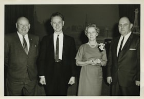
Interview with Les Francis by Eric Damer October 16, 2012 - Track 4
https://search.heritageburnaby.ca/link/oralhistory330
- Repository
- City of Burnaby Archives
- Date Range
- 1979-2012
- Length
- 0:12:38
- Summary
- This portion of the recording pertains to Les Francis's years of working with the municipality of Burnaby in the waterworks department and the changes he has noticed for present day workers.
- Repository
- City of Burnaby Archives
- Summary
- This portion of the recording pertains to Les Francis's years of working with the municipality of Burnaby in the waterworks department and the changes he has noticed for present day workers.
- Date Range
- 1979-2012
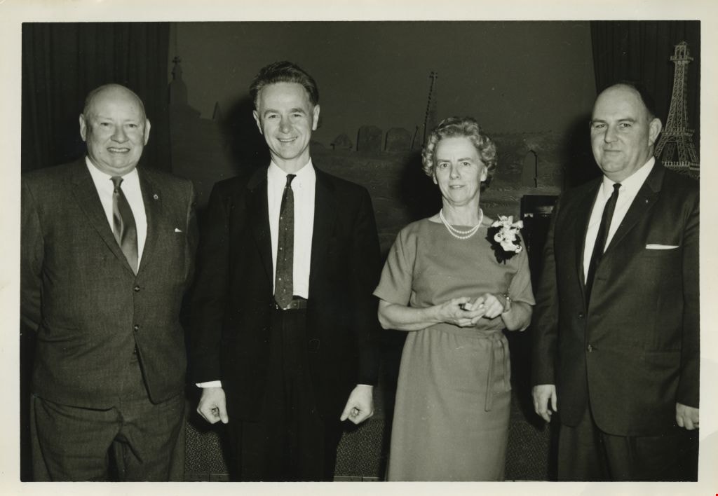
- Photo Info
- Les Francis (far right) receiving a Burnaby Long Service Award at the Gai Paree Supper Club, 1964. Item no. 485-070.
- Length
- 0:12:38
- Interviewer
- Damer, Eric
- Interview Date
- October 16, 2012
- Scope and Content
- Recording is an interview with Les Francis conducted by Burnaby Village Museum employee Eric Damer, October 16, 2012. Major theme discussed: the role of the municipal worker in the nineteen-thirties through the war years.
- Biographical Notes
- Les Francis was born in London, England, in 1914 and came with his family to Burnaby in 1919. Except for a few years away on special projects, Les has lived in Burnaby ever since. After attending Kingsway West Elementary and Burnaby South High Schools, Les joined the municipal work force. He first worked as a clerk in 1930 and later joined the Engineering Department where he spent his career maintaining and extending the municipal water system. Les Francis retired in 1979 as the City of Burnaby's Work's Superintendent.
- Total Tracks
- 4
- Total Length
- 0:43:18
- Interviewee Name
- Francis, Les
- Interview Location
- Interviewee's residence
- Interviewer Bio
- Eric Damer is a lifelong British Columbian born in Victoria, raised in Kamloops, and currently residing in Burnaby. After studying philosophy at the University of Victoria, he became interested in the educational forces that had shaped his own life. He completed master’s and doctoral degrees in educational studies at the University of British Columbia with a particular interest in the history of adult and higher education in the province. In 2012, Eric worked for the City of Burnaby as a field researcher and writer, conducting interviews for the City Archives and Museum Oral History Program.
- Collection/Fonds
- Community Heritage Commission Special Projects fonds
- Transcript Available
- None
- Media Type
- Sound Recording
Images
Audio Tracks
Track four of recording of interview with Les Francis
Track four of recording of interview with Les Francis
https://search.heritageburnaby.ca/media/hpo/_Data/_Archives_Oral_Histories/_Unrestricted/MSS171-010/MSS171-010_Track_4.mp3![Interview with Lama Tenzin Sherpa and Lama Sue Salter, [1977-2023] (interview content), interviewed 31 Jul. 2023 thumbnail](/media/hpo/_Data/_BVM_Sound_Recordings/Oral_Histories/2023_0016_0015_003.jpeg?width=280)
Interview with Lama Tenzin Sherpa and Lama Sue Salter
https://search.heritageburnaby.ca/link/museumdescription19637
- Repository
- Burnaby Village Museum
- Date
- [1977-2023] (interview content), interviewed 31 Jul. 2023
- Collection/Fonds
- Burnaby Village Museum fonds
- Description Level
- Item
- Physical Description
- 1 sound recording (wav) (65 min., 30 sec.) + 1 sound recording (mp3) (65 min., 9 sec.)
- Scope and Content
- Item consists of a recording of an oral history interview with Lama Tenzin Sherpa and Lama Sue Salter conducted by Burnaby Village Museum Registrar, James Binks on July 31 2023. 00:00:00 - 00:07:59 Interview opens with introductions. Lama Tenzin Sherpa provides biographical details about himself …
- Repository
- Burnaby Village Museum
- Collection/Fonds
- Burnaby Village Museum fonds
- Series
- Museum Oral Histories series
- Subseries
- Many Voices Project Interviews subseries
- Description Level
- Item
- Physical Description
- 1 sound recording (wav) (65 min., 30 sec.) + 1 sound recording (mp3) (65 min., 9 sec.)
- Material Details
- Interviewer: James Binks Interviewees: Lama Tenzin Sherpa and Lama Sue (Suzanne Salter) Location of Interview: Burnaby Village Museum Interview Date: July 31, 2023 Total Number of tracks: 1 Total Length of all Tracks: 01:05:30 Sound recording (wav) was converted to mp3 format for access on Heritage Burnaby
- Scope and Content
- Item consists of a recording of an oral history interview with Lama Tenzin Sherpa and Lama Sue Salter conducted by Burnaby Village Museum Registrar, James Binks on July 31 2023. 00:00:00 - 00:07:59 Interview opens with introductions. Lama Tenzin Sherpa provides biographical details about himself and his family life in Nepal and explains how his father sent him to the Sonada Monastery in India to become a monk in 1989 and how he took a vow to become a monk in 1992. He recalls his early years of living at the monastery. 00:08:00 - 00:18:38 Lama Tenzin recalls how he came to be a monk at the Salugara Monastery and describes the teachings and skills that he learned there including making tormas and playing traditional musical instruments. Lama Tenzin describes his three year retreat in Kalimpong, India 2008-2012 and how he became Lama Tenzin. Lama Sue Salter assists Lama Tenzin in telling his story. 00:18:39 - 00:25:10 Lama Tenzin talks about returning to the Sonada Monastery after completing his three year retreat and coming to Canada in 2015 to begin his work as a Lama at the Kagyu Kunkhyab Chuling centre (KKC) in Burnaby as well as the retreat centre on Salt Spring Island. 00:25:11 - 00:32:38 Lama Tenzin talks about learning English after arriving in Canada and finding his way around the city as a new immigrant. 00:32:59 - 00:43:13 Lama Susan Salter talks about meeting Lama Tenzin, her involvement with the Kagyu Kunkhyab Chuling Centre and it’s history in Burnaby on Sidley Street since 1977. 00:43:14 - 00:53:52 Lama Tenzin and Lama Susan Salter describe daily and weekly practices at the Kagyu Kunkhyab Chuling Centre in Burnaby, what a membership entails and types of educational programs offered at the centre. 00:53:53 - 00:59:23 Lama Tenzin and Lama Susan Salter talk about the location of their current centre in an apartment in Yale Town and retreat centre on Salt Spring Island and the challenges of finding affordable space for their centre. They reflect on the positive aspects of having their former centre location in Burnaby. 00:59:24 - 01:05:09 Lama Tenzin and Lama Susan Salter reflect on the future of the Kagyu Kunkhyab Chuling (KKC) and Kunzang Dechen Osel Ling (KDOL) meditation retreat centre on Salt Spring Island.
- History
- Interviewees' biographies: Lama Tenzin Sherpa was born in Nepal in 1977. When he was around 11 years old his father sent him to the Sonada Monastery (also known as sthe Samdrub Dhargay Choling Monastery) in West Bengal to begin his training to become a Tibetan Buddhist monk. In 1989, the same year that Kalu Rinpoche died, Lama Tenzin became a monk. He continued to live at the monastery for 20 years. In 2012, Lama Tenzin completed his three year retreat and took up various responsibilities at the Salagura Stupa Kunchab Chodey. In 2015, Lama Tenzin was invited to Canada as a resident teacher at the Tibetan Buddhist Dharma Centre “Kagyu Kunkhyab Chuling” (KKC) located at 4941 Sidley Street, Burnaby and the Niguma Meditation Centre's retreat centre Kunzang Dechen Osel Ling (KDOL) on Saltspring Island. Lama Sue Salter (Karma Lhamo) has been a student of Kalu Rinpoche since 1974. In 1980, she completed a three year retreat at the Palden Shangpa La Boulaye in France. She's served on the Board of Directors, as a retreat coordinator and a teacher in Tibetan at the Kagyu Kunkhyab Chuling and Kunzang Dechen Osel Ling (KDOL). Lama Sue also worked for years as a registered nurse and registered social worker and retired in 2018. Interviewer biography: James Binks has lived in the Lower Mainland since 2009 after relocating from Ontario. James holds a Bachelor of Arts in Anthropology from the University of British Columbia, where he conducted researched on heritage, environment, and globalization in India, Nepal, and Italy. At Burnaby Village Museum, James contributed to the exhibit “Truths Not Often Told: Being South Asian in Burnaby”.
- Creator
- Burnaby Village Museum
- Subjects
- Religions - Buddhism
- Buildings - Religious - Monasteries
- Migration
- Persons - South Asian Canadians
- Names
- Sherpa, Lama Tenzin
- Salter, Suzanne "Lama Sue"
- Kagyu Kunkhyab Chuling "KKC"
- Rinpoche, Lama Kalu
- Rinpoche, Lama Kyabje Kalu "Kalu Rinpoche"
- Kunzang Dechen Osel Ling "KDOL"
- Responsibility
- Binks, James
- Accession Code
- BV023.16.15
- Access Restriction
- No restrictions
- Reproduction Restriction
- No known restrictions
- Date
- [1977-2023] (interview content), interviewed 31 Jul. 2023
- Media Type
- Sound Recording
- Notes
- Title based on contents of item
- Transcription available
Images
![Interview with Lama Tenzin Sherpa and Lama Sue Salter, [1977-2023] (interview content), interviewed 31 Jul. 2023 thumbnail](/media/hpo/_Data/_BVM_Sound_Recordings/Oral_Histories/2023_0016_0015_003.jpeg)
Documents
Audio Tracks
Interview with Lama Tenzin Sherpa and Lama Sue Salter, [1977-2023] (interview content), interviewed 31 Jul. 2023
Interview with Lama Tenzin Sherpa and Lama Sue Salter, [1977-2023] (interview content), interviewed 31 Jul. 2023
https://search.heritageburnaby.ca/media/hpo/_Data/_BVM_Sound_Recordings/Oral_Histories/2023_0016_0015_002.mp3![Tony Fabian relaxing at a picnic table, [1970]. Item no. 549-026. thumbnail](/media/hpo/_Data/_Archives_Images/_Unrestricted/540/549-026.jpg?width=280)
Interview with Tony Fabian by Eric Damer October 10, 2012 - Track 4
https://search.heritageburnaby.ca/link/oralhistory325
- Repository
- City of Burnaby Archives
- Date Range
- 1972-2012
- Length
- 0:11:59
- Summary
- This portion of the recording pertains to Tony Fabian's involvement in the development of the Stream Preservation Bylaw in Burnaby. He discusses fish populations, air quality, and bird populations in Burnaby as well.
- Repository
- City of Burnaby Archives
- Summary
- This portion of the recording pertains to Tony Fabian's involvement in the development of the Stream Preservation Bylaw in Burnaby. He discusses fish populations, air quality, and bird populations in Burnaby as well.
- Date Range
- 1972-2012
- Photo Info
- Tony Fabian relaxing at a picnic table, [1970]. Item no. 549-026.
- Length
- 0:11:59
- Interviewer
- Damer, Eric
- Interview Date
- October 10, 2012
- Scope and Content
- Recording is an interview with Tony Fabian conducted by Burnaby Village Museum employee Eric Damer, October 10, 2012. Major theme discussed: environmental conservation practices in Burnaby.
- Biographical Notes
- Tony Fabian was born and raised in rural Saskatchewan in 1934. He and his wife moved to Burnaby in 1957, where he worked for the telephone company and raised a family. Tony has been an advocate for preservation of parklands and watercourses, helping to protect Burnaby and Deer Lake Parks and to create the Burnaby Fraser Foreshore and Barnet Marine Parks in the early nineteen-seventies, serving as a member of Burnaby’s Parks and Recreation Commission. Tony Fabian was presented with the 2008 City of Burnaby Environment Award for Community Stewardship.
- Total Tracks
- 5
- Total Length
- 0:47:48
- Interviewee Name
- Fabian, Tony
- Interview Location
- Burnaby Village Museum
- Interviewer Bio
- Eric Damer is a lifelong British Columbian born in Victoria, raised in Kamloops, and currently residing in Burnaby. After studying philosophy at the University of Victoria, he became interested in the educational forces that had shaped his own life. He completed master’s and doctoral degrees in educational studies at the University of British Columbia with a particular interest in the history of adult and higher education in the province. In 2012, Eric worked for the City of Burnaby as a field researcher and writer, conducting interviews for the City Archives and Museum Oral History Program.
- Collection/Fonds
- Community Heritage Commission Special Projects fonds
- Transcript Available
- None
- Media Type
- Sound Recording
Images
![Tony Fabian relaxing at a picnic table, [1970]. Item no. 549-026. thumbnail](/media/hpo/_Data/_Archives_Images/_Unrestricted/540/549-026.jpg)
Audio Tracks
Track four of recording of interview with Tony Fabian
Track four of recording of interview with Tony Fabian
https://search.heritageburnaby.ca/media/hpo/_Data/_Archives_Oral_Histories/_Unrestricted/MSS171-009/MSS171-009_Track_4.mp3
Interview with Tony Fabian by Eric Damer October 10, 2012 - Track 5
https://search.heritageburnaby.ca/link/oralhistory326
- Repository
- City of Burnaby Archives
- Date Range
- 1971-2012
- Length
- 0:09:30
- Summary
- This portion of the recording pertains to Tony Fabian's memories of the development of the Fraser River Foreshore and the Confederation Community Centre (previously named Confederation House).
- Repository
- City of Burnaby Archives
- Summary
- This portion of the recording pertains to Tony Fabian's memories of the development of the Fraser River Foreshore and the Confederation Community Centre (previously named Confederation House).
- Date Range
- 1971-2012
- Photo Info
- Tony Fabian relaxing at a picnic table, [1970]. Item no. 549-026.
- Length
- 0:09:30
- Interviewer
- Damer, Eric
- Interview Date
- October 10, 2012
- Scope and Content
- Recording is an interview with Tony Fabian conducted by Burnaby Village Museum employee Eric Damer, October 10, 2012. Major theme discussed: environmental conservation practices in Burnaby.
- Biographical Notes
- Tony Fabian was born and raised in rural Saskatchewan in 1934. He and his wife moved to Burnaby in 1957, where he worked for the telephone company and raised a family. Tony has been an advocate for preservation of parklands and watercourses, helping to protect Burnaby and Deer Lake Parks and to create the Burnaby Fraser Foreshore and Barnet Marine Parks in the early nineteen-seventies, serving as a member of Burnaby’s Parks and Recreation Commission. Tony Fabian was presented with the 2008 City of Burnaby Environment Award for Community Stewardship.
- Total Tracks
- 5
- Total Length
- 0:47:48
- Interviewee Name
- Fabian, Tony
- Interview Location
- Burnaby Village Museum
- Interviewer Bio
- Eric Damer is a lifelong British Columbian born in Victoria, raised in Kamloops, and currently residing in Burnaby. After studying philosophy at the University of Victoria, he became interested in the educational forces that had shaped his own life. He completed master’s and doctoral degrees in educational studies at the University of British Columbia with a particular interest in the history of adult and higher education in the province. In 2012, Eric worked for the City of Burnaby as a field researcher and writer, conducting interviews for the City Archives and Museum Oral History Program.
- Collection/Fonds
- Community Heritage Commission Special Projects fonds
- Transcript Available
- None
- Media Type
- Sound Recording
Images
Audio Tracks
Track five of recording of interview with Tony Fabian
Track five of recording of interview with Tony Fabian
https://search.heritageburnaby.ca/media/hpo/_Data/_Archives_Oral_Histories/_Unrestricted/MSS171-009/MSS171-009_Track_5.mp3
Burnaby Heights Neighbourhood
https://search.heritageburnaby.ca/link/landmark776
- Repository
- Burnaby Heritage Planning
- Associated Dates
- 1955-2008
- Heritage Value
- Up until the 1970s, this neighbourhood was known as Vancouver Heights. When a new park was created during that decade and named "Burnaby Heights Park," the name was gradually adopted by newcomers to the area. Today, you will hear residents refer to their neighbourhood as Burnaby Heights, Vancouver Heights, or just "The Heights." Throughout the 1960s and 1970s, the commercial district in this neighbourhood continued to grow and a Retail Merchants Association was formed which later became known as the Heights Merchants Association. The neighbourhood still retains a residential neighbourhood characteristic with an increasing number of apartment buildings and multi-family units being built over the past 20 years.
- Historic Neighbourhood
- Vancouver Heights (Historic Neighbourhood)
- Planning Study Area
- Burnaby Heights Area
Images


Willingdon Heights Neighbourhood
https://search.heritageburnaby.ca/link/landmark777
- Repository
- Burnaby Heritage Planning
- Associated Dates
- 1955-2008
- Heritage Value
- The convenient location of Willingdon Heights to the Trans Canada Highway, Lougheed Highway and Hastings Street has fostered its development as a primarily residential commuter neighbourhood. Characterised in the post-World War Two period by predominantly single-family developments, the neighbourhood has retained this identity despite some higher density apartment buildings now found there.
- Planning Study Area
- Willingdon Heights Area
Images


West Central Valley Neighbourhood
https://search.heritageburnaby.ca/link/landmark778
- Repository
- Burnaby Heritage Planning
- Associated Dates
- 1955-2008
- Heritage Value
- The West Central Valley Neighbourhood is home to the Bridge Business Park and is a primarily industrial neighbourhood. Similar to the adjacent Dawson-Delta Neighbourhood, West Central Valley offers businesses convenient access to major roads and highways.
- Historic Neighbourhood
- Broadview (Historic Neighbourhood)
- Planning Study Area
- West Central Valley Area
Images


Dawson-Delta Neighbourhood
https://search.heritageburnaby.ca/link/landmark779
- Repository
- Burnaby Heritage Planning
- Associated Dates
- 1955-2008
- Heritage Value
- The Dawson-Delta neighbourhood in Burnaby developed into one of Burnaby's numerous industrial areas after 1955. The Eastbrook Executive Business Park opened in the 1970s and the Willingdon Green Business Centre includes buildings from the 1980s to the 2000s. Convenient access to major roads and highways fostered these developments which remain zoned for industrial uses to this day.
- Planning Study Area
- Dawson-Delta Area
Images


Brentwood Neighbourhood
https://search.heritageburnaby.ca/link/landmark780
- Repository
- Burnaby Heritage Planning
- Associated Dates
- 1955-2008
- Heritage Value
- Between 1955 and 2001, the Brentwood Neighbourhood developed into one of Burnaby's four official Town Centres. The Brentwood Town Centre serves the north-west sector of the Municipality, providing facilities such as commercial developments - of which the Brentwood Mall is the most significant. Under Burnaby's Residential Development Framework adopted by Council in 1981, the Town Centre also incorporated a full range of multi-housing types and forms in close relationship with their commercial facilities. In 1996, the City adopted the Brentwood Town Centre Development Plant to solidify the area as a focus of higher-density and higher-intensity residential and commercial opportunities, public transit and supporting leisure facilities.
- Planning Study Area
- Brentwood Area
Images


Capitol Hill Neighbourhood
https://search.heritageburnaby.ca/link/landmark781
- Repository
- Burnaby Heritage Planning
- Associated Dates
- 1955-2008
- Heritage Value
- The Capitol Hill Neighbourhood remained a primarily residential neighbourhood after the population boom of the 1950s and 1960s. The commercial focus remained the Hastings Street corridor, while the City of Burnaby moved to protect a conservation area on the north side of Capitol Hill and dedicated parkland throughout the 1970s and 1980s.
- Historic Neighbourhood
- Capitol Hill (Historic Neighbourhood)
- Planning Study Area
- Capitol Hill Area
Images


Parkcrest-Aubrey Neighbourhood
https://search.heritageburnaby.ca/link/landmark782
- Repository
- Burnaby Heritage Planning
- Associated Dates
- 1955-2008
- Heritage Value
- After its initial subdivision and development in the early 1950s, the Parkcrest-Audrey Neighbourhood continued to be a primarily residential area. In the 1980 Residential Neighbourhood Environment Study, the area was characterised as a stable residential neighbourhood that was served by the major collector streets Holdom, Broadway, Parker and Kensington.
- Planning Study Area
- Parkcrest-Aubrey Area
Images


Sperling-Broadway Neighbourhood
https://search.heritageburnaby.ca/link/landmark789
- Repository
- Burnaby Heritage Planning
- Associated Dates
- 1955-2008
- Heritage Value
- By the 1970s, the Sperling-Broadway Neighbourhood was characterised as one of the Municipality's fastest growing residential areas. In 1980, it was estimated that slightly less than half of the homes were single-family residences, while the remaining development was taking the form of townhouse and high-rise apartments. The emphasis shifted back to single family housing during the construction of planned subdivisions such as the Camrose subdivision in the 1980s and the area remains primarily residential in nature. The neighbourhood is well-served by park facilities and is also home to the Burnaby Mountain Golf Course.
- Historic Neighbourhood
- Lochdale (Historic Neighbourhood)
- Planning Study Area
- Sperling-Broadway Area
Images


Lochdale Neighbourhood
https://search.heritageburnaby.ca/link/landmark790
- Repository
- Burnaby Heritage Planning
- Associated Dates
- 1955-2008
- Heritage Value
- Despite the rapid growth witnessed in Burnaby in the post-war years, the Lochdale Neighbourhood was characterised as a close-knit primarily residential community. Although a commercial zone developed along Sperling and Hastings, single-family, duplex and multi-family homes were the primary buildings in the area. Basement suites and student accommodation also flourished in this neighbourhood after the creation of Simon Fraser University on Burnaby Mountain.
- Historic Neighbourhood
- Lochdale (Historic Neighbourhood)
- Planning Study Area
- Lochdale Area
Images


Westridge Neighbourhood
https://search.heritageburnaby.ca/link/landmark791
- Repository
- Burnaby Heritage Planning
- Associated Dates
- 1955-2008
- Heritage Value
- The Westridge Neighbourhood is effectively separated into two areas by Inlet Drive. To the west of the highway lies a typical 1950s subdivision of single-family homes, while to the east is a newer (1970s) subdivision featuring larger lots and some low-rise units. In the 1980 Residential Neighbourhood Environment Study, Westridge was characterised as a stable community with little need for direct Municipal involvement in growth and development.
- Historic Neighbourhood
- Lochdale (Historic Neighbourhood)
- Planning Study Area
- Westridge Area
Images


Burnaby Mountain Neighbourhood
https://search.heritageburnaby.ca/link/landmark792
- Repository
- Burnaby Heritage Planning
- Associated Dates
- 1955-2008
- Heritage Value
- Burnaby Mountain had been dedicated as park in 1942, however the original park boundaries were reconsidered in 1952 with the development of the Trans Mountain Pipeline. Although the boundaries were adjusted to accommodate this project, significant conservation and park lands were left untouched. When, in 1962, the government of British Columbia determined the need for additional post-secondary facilities, Burnaby Mountain was chosen as the site for the new Simon Fraser University which opened in 1965. As early as 1964, the idea of establishing a townsite around the university had been discussed by Burnaby, but it was not until the mid-1990s that the idea came to fruition and by the early 2000s, a new housing development know as the UniverCity took shape on the mountain adjacent to the university.
- Historic Neighbourhood
- Barnet (Historic Neighbourhood)
- Planning Study Area
- Burnaby Mountain Area
Images


Lake City Neighbourhood
https://search.heritageburnaby.ca/link/landmark793
- Repository
- Burnaby Heritage Planning
- Associated Dates
- 1955-2008
- Heritage Value
- When Simon Fraser University opened in 1965, approximately sixteen industrial properties had been developed in the Lake City Industrial Park. In addition, significant tracts of land in the western portion had been pre-cleared and graded in anticipation of additional development, while most of the eastern half remained forested. Some of the early companies to locate in the area were Nabob Foods, Volkswagen Canada, British Columbia Television Broadcasting, Simpson Sears, and H.Y. Louie Company Limited. Both Imperial Oil and Shell Oil established petroleum storage and distribution facilities in the area. Initially a heavy industrial area, by 1979, single family neighbourhoods south of Lougheed Highway and west of Eagle Creek had been largely developed. By the mid1980's, the Burnaby 200 multi-family development along Forest Grove Drive had also been completed.
- Planning Study Area
- Lake City Area
Images


Ardingley-Sprott Neighbourhood
https://search.heritageburnaby.ca/link/landmark797
- Repository
- Burnaby Heritage Planning
- Associated Dates
- 1955-2008
- Heritage Value
- The Ardingley-Sprott Neighbourhood is primarily non-residential and developed in the 1970s west of the Burnaby Lake park area. It grew to include a large recreational component in the form of the Burnaby Lake Sports Complex and playing fields.
- Historic Neighbourhood
- Burnaby Lake (Historic Neighbourhood)
- Planning Study Area
- Ardingley-Sprott Area
Images


Cascade-Schou Neighbourhood
https://search.heritageburnaby.ca/link/landmark798
- Repository
- Burnaby Heritage Planning
- Associated Dates
- 1955-2008
- Heritage Value
- The Cascade-Schou neighbourhood, sometimes referred to as the Cascade Heights area, includes both the Burnaby General Hospital site, the Discovery Park facilities and is bordered on its eastern boundary by BCIT. Despite these health and science developments, the neighbourhood can still be considered to be a residential community. The housing stock includes single family homes as well as newer multi-family residences that developed throughout the 1980s and 1990s.
- Historic Neighbourhood
- Broadview (Historic Neighbourhood)
- Planning Study Area
- Cascade-Schou Area
Images


Douglas-Gilpin Neighbourhood
https://search.heritageburnaby.ca/link/landmark799
- Repository
- Burnaby Heritage Planning
- Associated Dates
- 1955-2008
- Heritage Value
- The Douglas-Gilpin Neighbourhood developed into a diverse area incorporating residential, business, educational and park districts in the period after 1955. The BCIT site was built in the early 1960s, shortly after the Burnaby Municipal Hall was located on Canada Way near Deer Lake in 1956. The construction of the Municipal Hall at this location fostered the creation of an administrative and business centre adjacent to the park, while the northern and central areas of the neighbourhood retained their primarily residential character.
- Historic Neighbourhood
- Burnaby Lake (Historic Neighbourhood)
- Planning Study Area
- Douglas-Gilpin Area
Images
