Narrow Results By
Subject
- Academic Disciplines 1
- Accidents 1
- Accidents - Train Accidents 6
- Adminstrative Groups - Committees 4
- Adornment - Jewelry 1
- Advertising Medium 1
- Advertising Medium - Flyer 4
- Advertising Medium - Poster 15
- Advertising Medium - Signs and Signboards 73
- Aerial Photographs
- Agriculture 2
- Agriculture - Farms 60
Interview with Toki Miyashita by Rod Fowler February 27, 1990 - Track 7
https://search.heritageburnaby.ca/link/oralhistory522
- Repository
- City of Burnaby Archives
- Date Range
- 1930-1990
- Length
- 00:13:56
- Summary
- This portion of the interview is about Toki Miyashita’s memories of the internment, separation of her father from the family to work on road camps, where she was born in Richmond at the Nelson Brothers “fishery”, confiscation of home in 1942, eventual Redress, and lingering feelings of fear and dis…
- Repository
- City of Burnaby Archives
- Summary
- This portion of the interview is about Toki Miyashita’s memories of the internment, separation of her father from the family to work on road camps, where she was born in Richmond at the Nelson Brothers “fishery”, confiscation of home in 1942, eventual Redress, and lingering feelings of fear and distrust in her family. She also talks about visiting Hiroshima on her trip to Japan in 1980
- Date Range
- 1930-1990
- Length
- 00:13:56
- Interviewer
- Fowler, Rod
- Interview Date
- February 27, 1990
- Scope and Content
- Recording is of an interview with Toki Miyashita, conducted by Rod Fowler. Toki Miyashita was one of eleven participants interviewed as part of the SFU/Burnaby Centennial Committee's oral history series titled, "Voices of Burnaby". The interview is about Toki Miyashita’s family’s internment during WWII, her awakening interest in Japanese culture after the war, her subsequent interest in teaching others about Japanese crafts and arts, and becoming a helpful intermediary between Burnaby and visitors from Japan. The interview explores her interest in the Ainu of Japan and their possible link to the aboriginals of BC, her impressions of the Ainu carver Nuburi Toko, and her involvement in the events surrounding the creation of the sculpture “Playground of the Gods” for Burnaby Mountain. The interview also contains interesting details about the art of Japanese flower-arranging. To view “Narrow By” terms for each track expand this description and see “Notes”.
- Biographical Notes
- Toki Miyashita was born in Richmond B.C., ca. 1935, at the Nelson Brothers “fishery”, a second generation Canadian descended from the Oikawa family who settled on Don and Lion Islands (Oikawa-shima). In 1942 the Japanese Canadians in BC were forcibly moved from the coast and their belongings confiscated. Toki Miyashita, her parents, two brothers, and grandparents were first taken to Hastings Park where her father was separated from the family to work in road camps, and the rest of the family were interned in New Denver. Her resourceful grandmother moved the family to land outside the internment camp, growing a large garden from seeds brought with her. In 1946 the family moved to Kamloops and in 1958, after finishing high school, Toki Miyashita moved to Montreal to be with relatives and a small Japanese community. At this time she became interested in Japanese culture and took a Japanese language course at age 22. She learned about Japanese flower-arranging (Ikebana), paper folding (Origami), silk doll making (from a Russian Jew), and how to wear a kimono. She began demonstrating these arts in schools and to other groups, which she continued doing when she, her husband and two young children moved to Burnaby in 1969. Toki Miyashita has been called an unpaid “ambassador” of Japanese culture to the Lower Mainland. She has acted as liaison between Burnaby and her sister city Kushiro in Japan, which involved her in the creation of the Ainu sculpture “Playground of the Gods” on Burnaby Mountain for Burnaby’s Centennial. Toki Miyashita is a recognized Master in Ikebana Sogetsu, a school of flower-arranging, and has served on the board of the Vancouver Ikebana Association. She also served on Burnaby’s Family Court in the 1980s.
- Total Tracks
- 11
- Total Length
- 01:34:10
- Interviewee Name
- Miyashita, Toki
- Interviewer Bio
- Rod Fowler returned to university as a mature student in the 1980s after working about twenty years in the field of economics and computerization in business in England, Europe and Western Canada. He graduated with a BA from SFU in both History and Sociology in 1987, his MA degree in Geography in 1989, and his PhD in Cultural Geography at SFU. He taught courses in Geography, Sociology, History and Canadian Studies at several Lower Mainland colleges, before becoming a full time member of the Geography Department at Kwantlen University College.
- Collection/Fonds
- SFU/Burnaby Centennial Committee fonds
- Transcript Available
- Transcript available
- Media Type
- Sound Recording
- Web Notes
- Interviews were digitized in 2015 allowing them to be accessible on Heritage Burnaby. The digitization project was initiated by the Community Heritage Commission with support from City of Burnaby Council.
Audio Tracks
Track seven of interview with Toki Miyashita
Track seven of interview with Toki Miyashita
https://search.heritageburnaby.ca/media/hpo/_Data/_Archives_Oral_Histories/_Unrestricted/MSS187-017/MSS187-017_Track_7.mp3
Simon Fraser University
https://search.heritageburnaby.ca/link/archivedescription37404
- Repository
- City of Burnaby Archives
- Date
- 1970
- Collection/Fonds
- Burnaby Historical Society fonds
- Description Level
- Item
- Physical Description
- 1 photograph : col. postcard ; 9 x 14 cm
- Scope and Content
- Aerial photographic postcard of Simon Fraser University and Burnaby Mountain.
- Repository
- City of Burnaby Archives
- Date
- 1970
- Collection/Fonds
- Burnaby Historical Society fonds
- Subseries
- Robert Prittie subseries
- Physical Description
- 1 photograph : col. postcard ; 9 x 14 cm
- Description Level
- Item
- Record No.
- 369-003
- Access Restriction
- No restrictions
- Reproduction Restriction
- Reproduce for fair dealing purposes only
- Accession Number
- BHS1999-01
- Scope and Content
- Aerial photographic postcard of Simon Fraser University and Burnaby Mountain.
- Subjects
- Buildings - Schools - Universities and Colleges
- Aerial Photographs
- Documentary Artifacts - Postcards
- Names
- Simon Fraser University
- Media Type
- Photograph
- Photographer
- Thompson, Fred
- Notes
- Title based on contents of photograph.
- Geographic Access
- University Drive
- Street Address
- 8888 University Drive
- Planning Study Area
- Burnaby Mountain Area
Images


Simon Fraser University
https://search.heritageburnaby.ca/link/archivedescription37405
- Repository
- City of Burnaby Archives
- Date
- 1970
- Collection/Fonds
- Burnaby Historical Society fonds
- Description Level
- Item
- Physical Description
- 1 photograph : col. postcard ; 9 x 14 cm
- Scope and Content
- Aerial photographic postcard taken looking west over the parking lot and the Academic Quadrangle at Simon Fraser University.
- Repository
- City of Burnaby Archives
- Date
- 1970
- Collection/Fonds
- Burnaby Historical Society fonds
- Subseries
- Robert Prittie subseries
- Physical Description
- 1 photograph : col. postcard ; 9 x 14 cm
- Description Level
- Item
- Record No.
- 369-004
- Access Restriction
- No restrictions
- Reproduction Restriction
- Reproduce for fair dealing purposes only
- Accession Number
- BHS1999-01
- Scope and Content
- Aerial photographic postcard taken looking west over the parking lot and the Academic Quadrangle at Simon Fraser University.
- Subjects
- Aerial Photographs
- Buildings - Schools - Universities and Colleges
- Documentary Artifacts - Postcards
- Names
- Simon Fraser University
- Media Type
- Photograph
- Photographer
- Hildred, Chris
- Notes
- Title based on caption
- Geographic Access
- University Drive
- Street Address
- 8888 University Drive
- Planning Study Area
- Burnaby Mountain Area
Images


Simon Fraser University Buildings
https://search.heritageburnaby.ca/link/archivedescription37406
- Repository
- City of Burnaby Archives
- Date
- 1970
- Collection/Fonds
- Burnaby Historical Society fonds
- Description Level
- Item
- Physical Description
- 1 photograph : col. postcard ; 9 x 14 cm
- Scope and Content
- Photographic postcard taken looking north towards Simon Fraser University. The caption on the back of the postcard reads: "The aerial view shows part of the university buildings on Burnaby Mountain, with Burrard Inlet, Indian Arm and the North Shore Mountains in the background."
- Repository
- City of Burnaby Archives
- Date
- 1970
- Collection/Fonds
- Burnaby Historical Society fonds
- Subseries
- Robert Prittie subseries
- Physical Description
- 1 photograph : col. postcard ; 9 x 14 cm
- Description Level
- Item
- Record No.
- 369-005
- Access Restriction
- No restrictions
- Reproduction Restriction
- Reproduce for fair dealing purposes only
- Accession Number
- BHS1999-01
- Scope and Content
- Photographic postcard taken looking north towards Simon Fraser University. The caption on the back of the postcard reads: "The aerial view shows part of the university buildings on Burnaby Mountain, with Burrard Inlet, Indian Arm and the North Shore Mountains in the background."
- Subjects
- Aerial Photographs
- Buildings - Schools - Universities and Colleges
- Geographic Features - Mountains
- Documentary Artifacts - Postcards
- Names
- Simon Fraser University
- Media Type
- Photograph
- Notes
- Title based on caption
- Geographic Access
- University Drive
- Street Address
- 8888 University Drive
- Planning Study Area
- Burnaby Mountain Area
Images


Burnaby Lake rowing course dredging
https://search.heritageburnaby.ca/link/archivedescription38303
- Repository
- City of Burnaby Archives
- Date
- 1971
- Collection/Fonds
- Burnaby Historical Society fonds
- Description Level
- Item
- Physical Description
- 1 photograph : col. ; 12.5 x 18 cm
- Scope and Content
- Aerial photograph of the Burnaby Lake rowing course being dredged in 1971, in preparation for the 1973 Canada Summer Games.
- Repository
- City of Burnaby Archives
- Date
- 1971
- Collection/Fonds
- Burnaby Historical Society fonds
- Subseries
- Photographs subseries
- Physical Description
- 1 photograph : col. ; 12.5 x 18 cm
- Description Level
- Item
- Record No.
- 400-001
- Access Restriction
- No restrictions
- Reproduction Restriction
- Reproduce for fair dealing purposes only
- Accession Number
- BHS2007-04
- Scope and Content
- Aerial photograph of the Burnaby Lake rowing course being dredged in 1971, in preparation for the 1973 Canada Summer Games.
- Media Type
- Photograph
- Notes
- Title based on contents of photograph
- Geographic Access
- Roberts Street
- Burnaby Lake
- Street Address
- 6871 Roberts Street
- Historic Neighbourhood
- Burnaby Lake (Historic Neighbourhood)
- Planning Study Area
- Burnaby Lake Area
Images

Reiko Moizumi’s wedding
https://search.heritageburnaby.ca/link/museumdescription4321
- Repository
- Burnaby Village Museum
- Date
- 27 Sep. 1975 (date of original), copied 2016
- Collection/Fonds
- Tokio and Yoshino Yamamoto family fonds
- Description Level
- Item
- Physical Description
- 1 photograph (tiff)
- Scope and Content
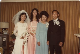
- Photograph of three women and one man posing at a wedding. Bride, Reiko Moizumi is standing on far left with bridesmaid Akemi Yamamoto Jordan to her right and then her parents Yoshino Yamamoto and Tokio Yamamoto. Group is standing in front of a gold curtain.
- Repository
- Burnaby Village Museum
- Collection/Fonds
- Tokio and Yoshino Yamamoto family fonds
- Description Level
- Item
- Physical Description
- 1 photograph (tiff)
- Scope and Content
- Photograph of three women and one man posing at a wedding. Bride, Reiko Moizumi is standing on far left with bridesmaid Akemi Yamamoto Jordan to her right and then her parents Yoshino Yamamoto and Tokio Yamamoto. Group is standing in front of a gold curtain.
- Accession Code
- BV016.11.5
- Access Restriction
- No restrictions
- Date
- 27 Sep. 1975 (date of original), copied 2016
- Media Type
- Photograph
- Scan Resolution
- 600
- Scan Date
- 4/24/2016
- Scale
- 100
Images

Reiko Moizumi’s wedding
https://search.heritageburnaby.ca/link/museumdescription4322
- Repository
- Burnaby Village Museum
- Date
- 27 Sep. 1975 (date of original), copied 2016
- Collection/Fonds
- Tokio and Yoshino Yamamoto family fonds
- Description Level
- Item
- Physical Description
- 1 photograph (tiff)
- Scope and Content
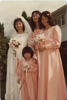
- Photograph of at the wedding of Reiko Moizumi (nee Yamamoto). From L-R: Reiko Moizumi, Kao Kakiuchi (flowergirl), Akemi Jordan (nee Yamamoto), Christine Matwick (nee Toda). Group is standing oustside, in front of a house.
- Repository
- Burnaby Village Museum
- Collection/Fonds
- Tokio and Yoshino Yamamoto family fonds
- Description Level
- Item
- Physical Description
- 1 photograph (tiff)
- Scope and Content
- Photograph of at the wedding of Reiko Moizumi (nee Yamamoto). From L-R: Reiko Moizumi, Kao Kakiuchi (flowergirl), Akemi Jordan (nee Yamamoto), Christine Matwick (nee Toda). Group is standing oustside, in front of a house.
- Accession Code
- BV016.11.6
- Access Restriction
- No restrictions
- Date
- 27 Sep. 1975 (date of original), copied 2016
- Media Type
- Photograph
- Scan Resolution
- 600
- Scan Date
- 4/24/2016
- Scale
- 100
Images

Reiko Moizumi’s wedding
https://search.heritageburnaby.ca/link/museumdescription4323
- Repository
- Burnaby Village Museum
- Date
- 27 Sep. 1975 (date of original), copied 2016
- Collection/Fonds
- Tokio and Yoshino Yamamoto family fonds
- Description Level
- Item
- Physical Description
- 1 photograph (tiff)
- Scope and Content
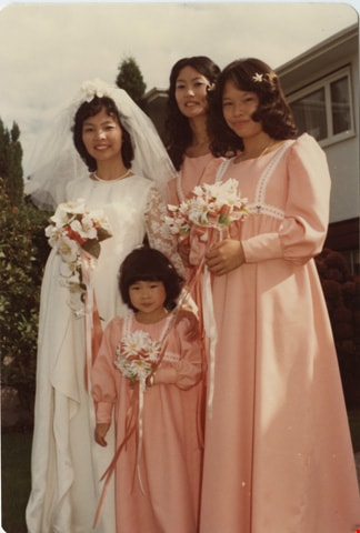
- Photograph of at the wedding of Reiko Moizumi (nee Yamamoto). From L-R: Reiko Moizumi, Kao Kakiuchi (flowergirl), Akemi Jordan (nee Yamamoto), Christine Matwick (nee Toda), Yoshino Yamamoto. Group is standing oustside, in front of a house.Group is standing in front of a gold curtain.
- Repository
- Burnaby Village Museum
- Collection/Fonds
- Tokio and Yoshino Yamamoto family fonds
- Description Level
- Item
- Physical Description
- 1 photograph (tiff)
- Scope and Content
- Photograph of at the wedding of Reiko Moizumi (nee Yamamoto). From L-R: Reiko Moizumi, Kao Kakiuchi (flowergirl), Akemi Jordan (nee Yamamoto), Christine Matwick (nee Toda), Yoshino Yamamoto. Group is standing oustside, in front of a house.Group is standing in front of a gold curtain.
- Names
- Jordan, Akemi Yamamoto
- Kakiuchi, Kao
- Matwick, Christine Toda
- Moizumi, Reiko Yamamoto
- Yamamoto, Yoshino Tamura
- Accession Code
- BV016.11.7
- Access Restriction
- No restrictions
- Date
- 27 Sep. 1975 (date of original), copied 2016
- Media Type
- Photograph
- Scan Resolution
- 600
- Scan Date
- 4/24/2016
- Scale
- 100
Images

Reiko Moizumi’s wedding
https://search.heritageburnaby.ca/link/museumdescription4324
- Repository
- Burnaby Village Museum
- Date
- 27 Sep. 1975 (date of original), copied 2016
- Collection/Fonds
- Tokio and Yoshino Yamamoto family fonds
- Description Level
- Item
- Physical Description
- 1 photograph (tiff)
- Scope and Content
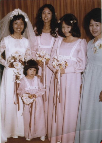
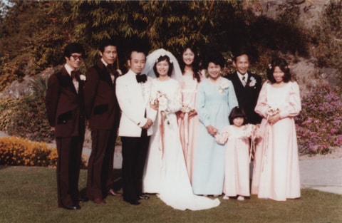
- Photograph of group portrait at the wedding of Reiko Moizumi and Masashi Moizumo. From Left to Right: Jun Hayashida, Mr. Sugita, Masashi Moizumo, Reiko Moizumi (nee Yamamoto), Akemi Jordan (nee Yakamoto), Yoshino Yamamoto (nee Tamura), Tokio Yamamoto, Christine Matwick (nee Toda). Flowergirl in fro…
- Repository
- Burnaby Village Museum
- Collection/Fonds
- Tokio and Yoshino Yamamoto family fonds
- Description Level
- Item
- Physical Description
- 1 photograph (tiff)
- Scope and Content
- Photograph of group portrait at the wedding of Reiko Moizumi and Masashi Moizumo. From Left to Right: Jun Hayashida, Mr. Sugita, Masashi Moizumo, Reiko Moizumi (nee Yamamoto), Akemi Jordan (nee Yakamoto), Yoshino Yamamoto (nee Tamura), Tokio Yamamoto, Christine Matwick (nee Toda). Flowergirl in front is Kayo Kaiuchi. Group is standing outside in front of trees.
- Names
- Hayashida, Jun
- Jordan, Akemi Yamamoto
- Kakiuchi, Kao
- Matwick, Christine Toda
- Moizumi, Masashi
- Moizumi, Reiko Yamamoto
- Sugita, Mr.
- Yamamoto, Tokio
- Yamamoto, Yoshino Tamura
- Accession Code
- BV016.11.8
- Access Restriction
- No restrictions
- Date
- 27 Sep. 1975 (date of original), copied 2016
- Media Type
- Photograph
- Scan Resolution
- 600
- Scan Date
- 4/24/2016
- Scale
- 100
Images

Lougheed Highway
https://search.heritageburnaby.ca/link/archivedescription79939
- Repository
- City of Burnaby Archives
- Date
- September 27, 1976
- Collection/Fonds
- Burnaby Public Library Contemporary Visual Archive Project
- Description Level
- Item
- Physical Description
- 1 photograph : b&w ; 11 x 16 cm mounted on cardboard
- Scope and Content
- Photograph shows an aerial view of Lougheed Highway looking southeast from Salish Court Tower west.
- Repository
- City of Burnaby Archives
- Date
- September 27, 1976
- Collection/Fonds
- Burnaby Public Library Contemporary Visual Archive Project
- Physical Description
- 1 photograph : b&w ; 11 x 16 cm mounted on cardboard
- Description Level
- Item
- Record No.
- 556-510
- Access Restriction
- No restrictions
- Reproduction Restriction
- Reproduce for fair dealing purposes only
- Accession Number
- 2013-13
- Scope and Content
- Photograph shows an aerial view of Lougheed Highway looking southeast from Salish Court Tower west.
- Media Type
- Photograph
- Photographer
- Campbell, Peg
- Notes
- Scope note taken directly from BPL photograph description.
- 1 b&w copy negative : 10 x 12.5 cm accompanying
- Geographic Access
- Lougheed Highway
- Historic Neighbourhood
- Burquitlam (Historic Neighbourhood)
- Planning Study Area
- Cameron Area
Images


Lougheed Highway
https://search.heritageburnaby.ca/link/archivedescription79940
- Repository
- City of Burnaby Archives
- Date
- July, 1976
- Collection/Fonds
- Burnaby Public Library Contemporary Visual Archive Project
- Description Level
- Item
- Physical Description
- 1 photograph : b&w ; 11 x 16 cm mounted on cardboard
- Scope and Content
- Photograph shows an aerial view looking east along Lougheed Highway at Salish Court Towers with the Cariboo Shopping Centre in the background.
- Repository
- City of Burnaby Archives
- Date
- July, 1976
- Collection/Fonds
- Burnaby Public Library Contemporary Visual Archive Project
- Physical Description
- 1 photograph : b&w ; 11 x 16 cm mounted on cardboard
- Description Level
- Item
- Record No.
- 556-511
- Access Restriction
- No restrictions
- Reproduction Restriction
- Reproduce for fair dealing purposes only
- Accession Number
- 2013-13
- Scope and Content
- Photograph shows an aerial view looking east along Lougheed Highway at Salish Court Towers with the Cariboo Shopping Centre in the background.
- Media Type
- Photograph
- Photographer
- Gardiner, Robert
- Notes
- Scope note taken directly from BPL photograph description.
- 1 b&w copy negative : 10 x 12.5 cm accompanying
- Geographic Access
- Lougheed Highway
- Historic Neighbourhood
- Burquitlam (Historic Neighbourhood)
- Planning Study Area
- Cameron Area
Images


Burnaby Centre
https://search.heritageburnaby.ca/link/archivedescription79941
- Repository
- City of Burnaby Archives
- Date
- September 27, 1976
- Collection/Fonds
- Burnaby Public Library Contemporary Visual Archive Project
- Description Level
- Item
- Physical Description
- 1 photograph : b&w ; 11 x 16 cm mounted on cardboard
- Scope and Content
- Photograph shows an aerial view of Burnaby Centre looking east from Central Park Place. Kingsway is on the right and Grange Street is on the left.
- Repository
- City of Burnaby Archives
- Date
- September 27, 1976
- Collection/Fonds
- Burnaby Public Library Contemporary Visual Archive Project
- Physical Description
- 1 photograph : b&w ; 11 x 16 cm mounted on cardboard
- Description Level
- Item
- Record No.
- 556-512
- Access Restriction
- No restrictions
- Reproduction Restriction
- Reproduce for fair dealing purposes only
- Accession Number
- 2013-13
- Scope and Content
- Photograph shows an aerial view of Burnaby Centre looking east from Central Park Place. Kingsway is on the right and Grange Street is on the left.
- Media Type
- Photograph
- Photographer
- Norton, Paul
- Notes
- Scope note taken directly from BPL photograph description.
- 1 b&w copy negative : 10 x 12.5 cm accompanying
- Geographic Access
- Kingsway
- Grange Street
- Historic Neighbourhood
- Central Park (Historic Neighbourhood)
- Planning Study Area
- Maywood Area
Images


Vantage Point Highrise
https://search.heritageburnaby.ca/link/archivedescription79942
- Repository
- City of Burnaby Archives
- Date
- October, 1976
- Collection/Fonds
- Burnaby Public Library Contemporary Visual Archive Project
- Description Level
- Item
- Physical Description
- 1 photograph : b&w ; 11 x 16 cm mounted on cardboard
- Scope and Content
- Photograph shows a view of Vantage Point Highrise at Lougheed Highway and Bellwood Avenue with Trans-Cold Refrigeration on Douglas Road in the foreground.
- Repository
- City of Burnaby Archives
- Date
- October, 1976
- Collection/Fonds
- Burnaby Public Library Contemporary Visual Archive Project
- Physical Description
- 1 photograph : b&w ; 11 x 16 cm mounted on cardboard
- Description Level
- Item
- Record No.
- 556-513
- Access Restriction
- No restrictions
- Reproduction Restriction
- Reproduce for fair dealing purposes only
- Accession Number
- 2013-13
- Scope and Content
- Photograph shows a view of Vantage Point Highrise at Lougheed Highway and Bellwood Avenue with Trans-Cold Refrigeration on Douglas Road in the foreground.
- Media Type
- Photograph
- Photographer
- Salmon, Stu
- Notes
- Scope note taken directly from BPL photograph description.
- 1 b&w copy negative : 10 x 12.5 cm accompanying
- Planning Study Area
- Dawson-Delta Area
Images


Kingsway
https://search.heritageburnaby.ca/link/archivedescription79943
- Repository
- City of Burnaby Archives
- Date
- September 15, 1976
- Collection/Fonds
- Burnaby Public Library Contemporary Visual Archive Project
- Description Level
- Item
- Physical Description
- 1 photograph : b&w ; 11 x 16 cm mounted on cardboard
- Scope and Content
- Photograph shows a view of Kingsway looking southeast from the 21st floor of the Panorama Towers in Grange Street. The Esso Car Clinic is in the centre of the photo.
- Repository
- City of Burnaby Archives
- Date
- September 15, 1976
- Collection/Fonds
- Burnaby Public Library Contemporary Visual Archive Project
- Physical Description
- 1 photograph : b&w ; 11 x 16 cm mounted on cardboard
- Description Level
- Item
- Record No.
- 556-514
- Access Restriction
- No restrictions
- Reproduction Restriction
- Reproduce for fair dealing purposes only
- Accession Number
- 2013-13
- Scope and Content
- Photograph shows a view of Kingsway looking southeast from the 21st floor of the Panorama Towers in Grange Street. The Esso Car Clinic is in the centre of the photo.
- Subjects
- Aerial Photographs
- Media Type
- Photograph
- Photographer
- McCarron, John
- Notes
- Scope note taken directly from BPL photograph description.
- 1 b&w copy negative : 10 x 12.5 cm accompanying
- Geographic Access
- Kingsway
- Historic Neighbourhood
- Central Park (Historic Neighbourhood)
- Planning Study Area
- Maywood Area
Images


Kingsway
https://search.heritageburnaby.ca/link/archivedescription79944
- Repository
- City of Burnaby Archives
- Date
- October 20, 1976
- Collection/Fonds
- Burnaby Public Library Contemporary Visual Archive Project
- Description Level
- Item
- Physical Description
- 1 photograph : b&w ; 11 x 16 cm mounted on cardboard
- Scope and Content
- Photograph shows a view of Kingsway looking northwest, taken from the Hall Towers at Edmonds Street and Kingsway.
- Repository
- City of Burnaby Archives
- Date
- October 20, 1976
- Collection/Fonds
- Burnaby Public Library Contemporary Visual Archive Project
- Physical Description
- 1 photograph : b&w ; 11 x 16 cm mounted on cardboard
- Description Level
- Item
- Record No.
- 556-515
- Access Restriction
- No restrictions
- Reproduction Restriction
- Reproduce for fair dealing purposes only
- Accession Number
- 2013-13
- Scope and Content
- Photograph shows a view of Kingsway looking northwest, taken from the Hall Towers at Edmonds Street and Kingsway.
- Subjects
- Aerial Photographs
- Media Type
- Photograph
- Photographer
- Ross, Martha
- Notes
- Scope note taken directly from BPL photograph description.
- 1 b&w copy negative : 10 x 12.5 cm accompanying
- Geographic Access
- Kingsway
- Historic Neighbourhood
- Edmonds (Historic Neighbourhood)
Images


Edmonds Neighbourhood
https://search.heritageburnaby.ca/link/archivedescription79945
- Repository
- City of Burnaby Archives
- Date
- October 20, 1976
- Collection/Fonds
- Burnaby Public Library Contemporary Visual Archive Project
- Description Level
- Item
- Physical Description
- 1 photograph : b&w ; 11 x 16 cm mounted on cardboard
- Scope and Content
- Photograph shows a view of the neighbourhood south of Kingsway and Edmonds Street. The photo was taken from Hall Towers.
- Repository
- City of Burnaby Archives
- Date
- October 20, 1976
- Collection/Fonds
- Burnaby Public Library Contemporary Visual Archive Project
- Physical Description
- 1 photograph : b&w ; 11 x 16 cm mounted on cardboard
- Description Level
- Item
- Record No.
- 556-516
- Access Restriction
- No restrictions
- Reproduction Restriction
- Reproduce for fair dealing purposes only
- Accession Number
- 2013-13
- Scope and Content
- Photograph shows a view of the neighbourhood south of Kingsway and Edmonds Street. The photo was taken from Hall Towers.
- Subjects
- Aerial Photographs
- Media Type
- Photograph
- Photographer
- Ross, Martha
- Notes
- Scope note taken directly from BPL photograph description.
- 1 b&w copy negative : 10 x 12.5 cm accompanying
- Historic Neighbourhood
- Edmonds (Historic Neighbourhood)
Images


Homes near Keith and McGregor
https://search.heritageburnaby.ca/link/archivedescription79946
- Repository
- City of Burnaby Archives
- Date
- September 16, 1976
- Collection/Fonds
- Burnaby Public Library Contemporary Visual Archive Project
- Description Level
- Item
- Physical Description
- 1 photograph : b&w ; 11 x 16 cm mounted on cardboard
- Scope and Content
- Photograph shows a view of backyards of houses near Keith Street and McGregor Avenue with the flats south of Marine Drive in the background.
- Repository
- City of Burnaby Archives
- Date
- September 16, 1976
- Collection/Fonds
- Burnaby Public Library Contemporary Visual Archive Project
- Physical Description
- 1 photograph : b&w ; 11 x 16 cm mounted on cardboard
- Description Level
- Item
- Record No.
- 556-517
- Access Restriction
- No restrictions
- Reproduction Restriction
- Reproduce for fair dealing purposes only
- Accession Number
- 2013-13
- Scope and Content
- Photograph shows a view of backyards of houses near Keith Street and McGregor Avenue with the flats south of Marine Drive in the background.
- Subjects
- Aerial Photographs
- Media Type
- Photograph
- Photographer
- Ross, Martha
- Notes
- Scope note taken directly from BPL photograph description.
- 1 b&w copy negative : 10 x 12.5 cm accompanying
- Geographic Access
- McGregor Avenue
- Keith Street
- Historic Neighbourhood
- Alta-Vista (Historic Neighbourhood)
- Planning Study Area
- Sussex-Nelson Area
Images


Sperling Avenue Looking North
https://search.heritageburnaby.ca/link/archivedescription79947
- Repository
- City of Burnaby Archives
- Date
- September 24, 1976
- Collection/Fonds
- Burnaby Public Library Contemporary Visual Archive Project
- Description Level
- Item
- Physical Description
- 1 photograph : b&w ; 11 x 16 cm mounted on cardboard
- Scope and Content
- Photograph shows a view of Sperling Avenue looking north from Eagles Drive.
- Repository
- City of Burnaby Archives
- Date
- September 24, 1976
- Collection/Fonds
- Burnaby Public Library Contemporary Visual Archive Project
- Physical Description
- 1 photograph : b&w ; 11 x 16 cm mounted on cardboard
- Description Level
- Item
- Record No.
- 556-518
- Access Restriction
- No restrictions
- Reproduction Restriction
- Reproduce for fair dealing purposes only
- Accession Number
- 2013-13
- Scope and Content
- Photograph shows a view of Sperling Avenue looking north from Eagles Drive.
- Subjects
- Aerial Photographs
- Media Type
- Photograph
- Photographer
- Norton, Paul
- Notes
- Scope note taken directly from BPL photograph description.
- 1 b&w copy negative : 10 x 12.5 cm accompanying
- Geographic Access
- Sperling Avenue
- Historic Neighbourhood
- Burnaby Lake (Historic Neighbourhood)
- Planning Study Area
- Morley-Buckingham Area
Images


Sperling Avenue Looking South
https://search.heritageburnaby.ca/link/archivedescription79948
- Repository
- City of Burnaby Archives
- Date
- September 20, 1976
- Collection/Fonds
- Burnaby Public Library Contemporary Visual Archive Project
- Description Level
- Item
- Physical Description
- 1 photograph : b&w ; 11 x 16 cm mounted on cardboard
- Scope and Content
- Photograph shows a view of Sperling Avenue looking south from Broadway.
- Repository
- City of Burnaby Archives
- Date
- September 20, 1976
- Collection/Fonds
- Burnaby Public Library Contemporary Visual Archive Project
- Physical Description
- 1 photograph : b&w ; 11 x 16 cm mounted on cardboard
- Description Level
- Item
- Record No.
- 556-519
- Access Restriction
- No restrictions
- Reproduction Restriction
- Reproduce for fair dealing purposes only
- Accession Number
- 2013-13
- Scope and Content
- Photograph shows a view of Sperling Avenue looking south from Broadway.
- Subjects
- Aerial Photographs
- Media Type
- Photograph
- Photographer
- McCarron, John
- Notes
- Scope note taken directly from BPL photograph description.
- 1 b&w copy negative : 10 x 12.5 cm accompanying
- Geographic Access
- Sperling Avenue
- Historic Neighbourhood
- Lochdale (Historic Neighbourhood)
- Planning Study Area
- Sperling-Broadway Area
Images


Highway No. 1
https://search.heritageburnaby.ca/link/archivedescription79950
- Repository
- City of Burnaby Archives
- Date
- September, 1976
- Collection/Fonds
- Burnaby Public Library Contemporary Visual Archive Project
- Description Level
- Item
- Physical Description
- 1 photograph : b&w ; 11 x 16 cm mounted on cardboard
- Scope and Content
- Photograph shows a view of the No. 1 Highway looking northwest from Sprott Street overpass.
- Repository
- City of Burnaby Archives
- Date
- September, 1976
- Collection/Fonds
- Burnaby Public Library Contemporary Visual Archive Project
- Physical Description
- 1 photograph : b&w ; 11 x 16 cm mounted on cardboard
- Description Level
- Item
- Record No.
- 556-520
- Access Restriction
- No restrictions
- Reproduction Restriction
- Reproduce for fair dealing purposes only
- Accession Number
- 2013-13
- Scope and Content
- Photograph shows a view of the No. 1 Highway looking northwest from Sprott Street overpass.
- Subjects
- Aerial Photographs
- Media Type
- Photograph
- Photographer
- Salmon, Stu
- Notes
- Scope note taken directly from BPL photograph description.
- 1 b&w copy negative : 10 x 12.5 cm accompanying
- Geographic Access
- Trans Canada Highway
- Historic Neighbourhood
- Burnaby Lake (Historic Neighbourhood)
- Planning Study Area
- Douglas-Gilpin Area
Images
