Narrow Results By
Subject
- Advertising Medium - Signs and Signboards 1
- Agriculture - Farms 1
- Building Components 2
- Buildings - Commercial - Restaurants 1
- Buildings - Residential - Houses 1
- Communication Artifacts 2
- Documentary Artifacts - Receipts 1
- Education 1
- Events - Anniversaries 1
- Furniture 3
- Household Accessory 5
- Recreational Activities 1
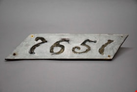
address panel
https://search.heritageburnaby.ca/link/museumartifact91313
- Repository
- Burnaby Village Museum
- Accession Code
- BV021.21.21
- Description
- The number "7651" are stenciled out across the panel, surrounded by gray paint. The panel itself is a diagonal rectangle (parallelogram) shaped sign. There are four screws, one in each corner, with two rusting screws still intact in both the bottom right and left corner. The reverse of the panel is yellowed, and was also painted gray.
- Object History
- Panel was found in the attic of Love Farmhouse August 2021, where it had been since the farmhouse restoration project in the late 1990's. This panel was an original fixture on the home.
- Category
- 08. Communication Artifacts
- Classification
- Documentary Artifacts - - Other Documents
- Object Term
- Address Label
- Colour
- Gray
- Measurements
- length: 46 cm width: 12.8 cm
- Country Made
- Canada
- Province Made
- British Columbia
- Site/City Made
- Burnaby
- Subjects
- Household Accessory
- Names
- Love Family
- Geographic Access
- Cumberland Street
- Historic Neighbourhood
- East Burnaby (Historic Neighbourhood)
Images


Alfred & Sarah Chrisp Residence
https://search.heritageburnaby.ca/link/landmark556
- Repository
- Burnaby Heritage Planning
- Description
- Rsidential building.
- Associated Dates
- 1913
- Street View URL
- Google Maps Street View
- Repository
- Burnaby Heritage Planning
- Geographic Access
- 11th Avenue
- Associated Dates
- 1913
- Description
- Rsidential building.
- Heritage Value
- This high-quality Craftsman bungalow was built for Alfred John Chrisp (1882-1944) and his wife Sarah Hannah Chrisp (née Hindmarch, 1883-1954). Starting in 1908, Alfred worked as an accountant for the CPR in New Westminster, and he and Sarah were married there in 1910. This house features a front gabled roof and gabled front porch, and is notable for its elaborate stained glass windows in the front door glazing, sidelights and the narrow transom over the front elevation window. Maintaining a very high degree of original integrity, the bungalow features lapped siding at the foundation level, a shingle clad main floor, a combination of casement and double-hung windows and square tapered porch columns.
- Locality
- East Burnaby
- Historic Neighbourhood
- East Burnaby (Historic Neighbourhood)
- Planning Study Area
- Edmonds Area
- Street Address
- 7349 11th Avenue
- Street View URL
- Google Maps Street View
Images


Armstrong Elementary School
https://search.heritageburnaby.ca/link/landmark762
- Repository
- Burnaby Heritage Planning
- Geographic Access
- Armstrong Avenue
- Associated Dates
- 1911
- Heritage Value
- The site for the Armstrong Avenue school was cleared in 1911. In 1955 the original structure was replaced by a new building and additions were constructed in 1962, 1964, 1967 and 1969. Armstrong Avenue was named after J.C. Armstrong, an early property owner of Burnaby who was involved in the effort to make Burnaby a municipality in 1892.
- Historic Neighbourhood
- East Burnaby (Historic Neighbourhood)
- Planning Study Area
- Cariboo-Armstrong Area
- Street Address
- 8757 Armstrong Avenue
- Street View URL
- Google Maps Street View
Images


Arrow Neon Sign
https://search.heritageburnaby.ca/link/landmark861
- Repository
- Burnaby Heritage Planning
- Description
- Commercial building.
- Associated Dates
- 1961
- Other Names
- Lost in the 50's Drive-in
- Street View URL
- Google Maps Street View
- Repository
- Burnaby Heritage Planning
- Other Names
- Lost in the 50's Drive-in
- Geographic Access
- Edmonds Street
- Associated Dates
- 1961
- Description
- Commercial building.
- Heritage Value
- The Arrow Neon Sign was built in 1961 by the Neonette Sign Company of New Westminster when this property was opened as the Tomahawk Drive-in Restaurant. The restaurant was later known as Lindy's Burger and in 1990, the business was renamed Lost in the 50's Drive-in. It stands 20-foot tall and is composed of a large double-sided hollow steel panel serpentine arrow mounted on a pole supporting a lexan sign panel measuring approximately 8 feet wide by 4 feet tall. The sign was designed with three illuminated features: a round lamp at the top of the pole, a double-sided rectangular fluorescent sign panel box, and two double-sided rows of orange neon arrows that follow the large serpentine arrow. The Arrow Neon Sign remains as a rare surviving example of neon sign art in the city and is the only historic neon sign in South Burnaby. The sign has gained prominence over the years as it has been associated with this small iconic drive-in which has also been utilized as a set for film production. Additionally, the drive-in has played a prominent role in the Edmonds community as a popular setting for recent "Show and Shine" participants to park their classic cars.
- Locality
- Edmonds
- Historic Neighbourhood
- East Burnaby (Historic Neighbourhood)
- Planning Study Area
- Lakeview-Mayfield Area
- Builder
- Neonette Sign Company
- Community
- Burnaby
- Contributing Resource
- Structure
- Ownership
- Public (local)
- Street Address
- 7741 Edmonds Street
- Street View URL
- Google Maps Street View
Images


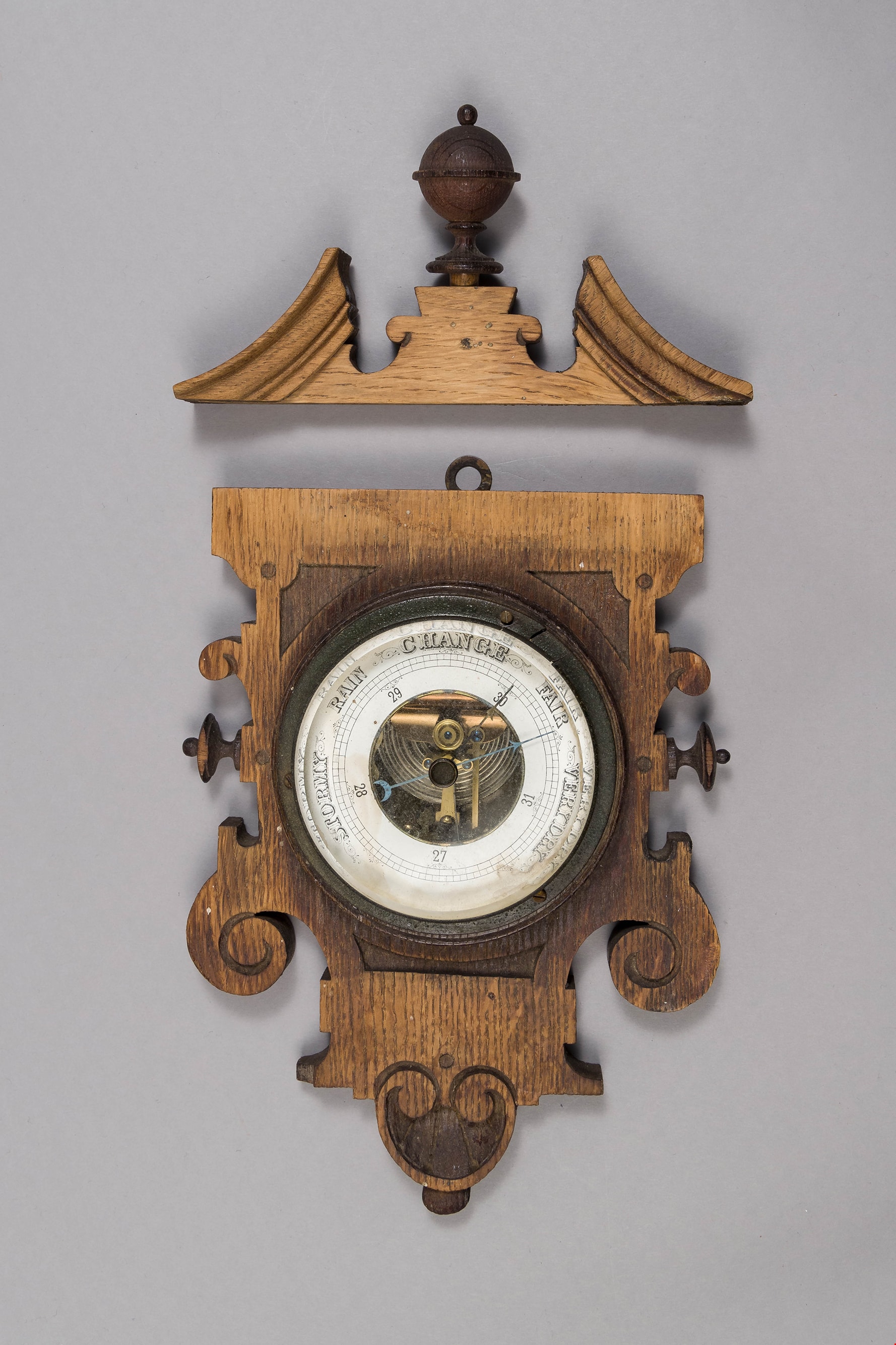
barometer
https://search.heritageburnaby.ca/link/museumartifact90178
- Repository
- Burnaby Village Museum
- Accession Code
- BV019.8.16
- Description
- barometer; aneroid barometer secured to a carved wood plaque; barometer has a calibrated dial to indicate air pressure; text on dial reads: "VERY DRY", "FAIR", "CHANGE", "RAIN", and "STORMY"; flat metal loop at top of wood plaque for hanging. Dark stained carved wood decorative scroll with finial; has detached from base plaque.
- Object History
- Object used in the Love Farmhouse, currently on site at Burnaby Village Museum.
- Geographic Access
- Cumberland Street
- Street Address
- 7651 Cumberland Street
- Historic Neighbourhood
- East Burnaby (Historic Neighbourhood)
- Planning Study Area
- Cariboo-Armstrong Area
Images
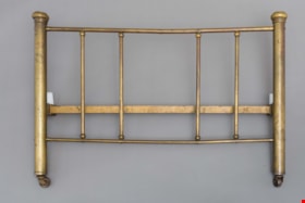
bed headboard
https://search.heritageburnaby.ca/link/museumartifact39541
- Repository
- Burnaby Village Museum
- Accession Code
- BV998.74.1
- Description
- Headboard, brass; has corner posts; on ball-bearing casters; top and bottom rails with five supporting rails; posts are 2" thick; top and bottom rails are 3/4" thick and verticals are 5/8" thick
- Object History
- The bed belonged to Leonard Love, son of Jesse and Martha Love.
- Category
- 02. Furnishings
- Classification
- Sleeping and Reclining Furniture
- Object Term
- Headboard
- Subjects
- Furniture
- Geographic Access
- Cumberland Street
- Historic Neighbourhood
- East Burnaby (Historic Neighbourhood)
- Planning Study Area
- Second Street Area
Images

Buena Vista Neighbourhood
https://search.heritageburnaby.ca/link/landmark759
- Repository
- Burnaby Heritage Planning
- Associated Dates
- 1905-1924
- Heritage Value
- The Buena Vista neighbourhood (so named for its wonderful views) grew out of its proximity to Edmonds and New Westminster and was developed in the period 1911-1912. By the 1950s, the area had been further subdivided and in 1986, Burnaby Municipal Council adopted the Cariboo Hills Development Plan for the neighbourhood to maintain its character as a residential area of the city.
- Historic Neighbourhood
- East Burnaby (Historic Neighbourhood)
- Planning Study Area
- Cariboo-Armstrong Area
Images


Buena Vista Subdivision Residence
https://search.heritageburnaby.ca/link/landmark661
- Repository
- Burnaby Heritage Planning
- Description
- Residential building.
- Associated Dates
- 1911
- Street View URL
- Google Maps Street View
- Repository
- Burnaby Heritage Planning
- Geographic Access
- Armstrong Avenue
- Associated Dates
- 1911
- Description
- Residential building.
- Heritage Value
- This modest, hipped roof, cottage-style bungalow is distinguished by a full width front verandah. It was built as part of the Buena Vista subdivision in about 1911 by the Leibly & Blumer Real Estate Company. It was reported in The British Columbian in 1911: “Ten houses are now being erected by the company on the property, solid substantial five or six-room buildings that appeals to the homeseeker”. Retaining a high degree of integrity, this residence displays its original double-hung windows and lapped wooden siding. Houses of this type were often constructed from a complete package of materials offered by building supply companies, and were extremely popular due to their low cost and ease of construction.
- Locality
- East Burnaby
- Historic Neighbourhood
- East Burnaby (Historic Neighbourhood)
- Planning Study Area
- Cariboo-Armstrong Area
- Area
- 413.72
- Contributing Resource
- Building
- Ownership
- Private
- Street Address
- 8941 Armstrong Avenue
- Street View URL
- Google Maps Street View
Images


building
https://search.heritageburnaby.ca/link/museumartifact3846
- Repository
- Burnaby Village Museum
- Accession Code
- BV988.33.1
- Description
- The core of the Jessie Love farm house is a 1893 two story, pioneer tent style building. The home was added to over the years and became a large Craftsmen style farm house.
- Object History
- Built on Cumberland Road in Burnaby in 1893. Music Room/Parlour/Living Room and bedrooms above added c.1898. Kitchen added c.1908. The home of Jesse and Martha Love and their eleven children. One of Burnaby's oldest structures. The home was moved to Burnaby Village Museum in the late 1980s and has been partially restored to its 1920s appearance.
- Category
- 01. Built Environment Objects
- Classification
- Structures - - Dwellings
- Object Term
- House
- Colour
- Brown
- Culture
- Canadian
- Geographic Access
- Cumberland Street
- Street Address
- 6501 Deer Lake Avenue
- Historic Neighbourhood
- East Burnaby (Historic Neighbourhood)
- Planning Study Area
- Cariboo-Armstrong Area
Images


Cariboo-Armstrong Neighbourhood
https://search.heritageburnaby.ca/link/landmark825
- Repository
- Burnaby Heritage Planning
- Associated Dates
- 1955-2008
- Heritage Value
- The Cariboo-Armstrong Neighbourhood was mainly subdivided in the 1950s during the major building boom in Burnaby throughout the post-war years. Considered a primarily residential area, the neighbourhood has quick and convenient access to major highways and roads as well as being bordered to the north by the George Derby Conservation area.
- Historic Neighbourhood
- East Burnaby (Historic Neighbourhood)
- Planning Study Area
- Cariboo-Armstrong Area
Images


Cariboo Hill Secondary School
https://search.heritageburnaby.ca/link/landmark837
- Repository
- Burnaby Heritage Planning
- Geographic Access
- 16th Avenue
- Associated Dates
- 1961
- Heritage Value
- By 1961, three new elementary schools had been built in the northeast section of Burnaby - Armstrong, Seaforth, and Lyndhurst. With growing enrolment at each, too many students were required to travel a farther distance to attend Edmonds Junior High School. As a result, the Cariboo Hill Secondary School was built in 1961 and opened with 410 students. Its peak enrolment was during the 1974 school year when over 1100 students attended. Additions to the school were made in 1969, 1971 and 1974.
- Historic Neighbourhood
- East Burnaby (Historic Neighbourhood)
- Planning Study Area
- Cariboo-Armstrong Area
- Street Address
- 8580 16th Avenue
- Street View URL
- Google Maps Street View
Images

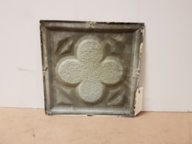
ceiling panel
https://search.heritageburnaby.ca/link/museumartifact81704
- Repository
- Burnaby Village Museum
- Accession Code
- BV988.33.109
- Description
- A single pressed metal ceiling panel with a raised four leaf clover motif. There are traces of a cream white paint at the edges. No rust.
- Object History
- This item was taken from Love farmhouse.
- Measurements
- The panel is 31.5 cm square.
- Geographic Access
- Cumberland Street
- Historic Neighbourhood
- East Burnaby (Historic Neighbourhood)
Images

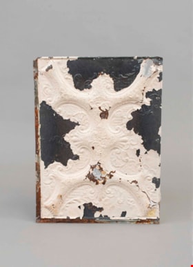
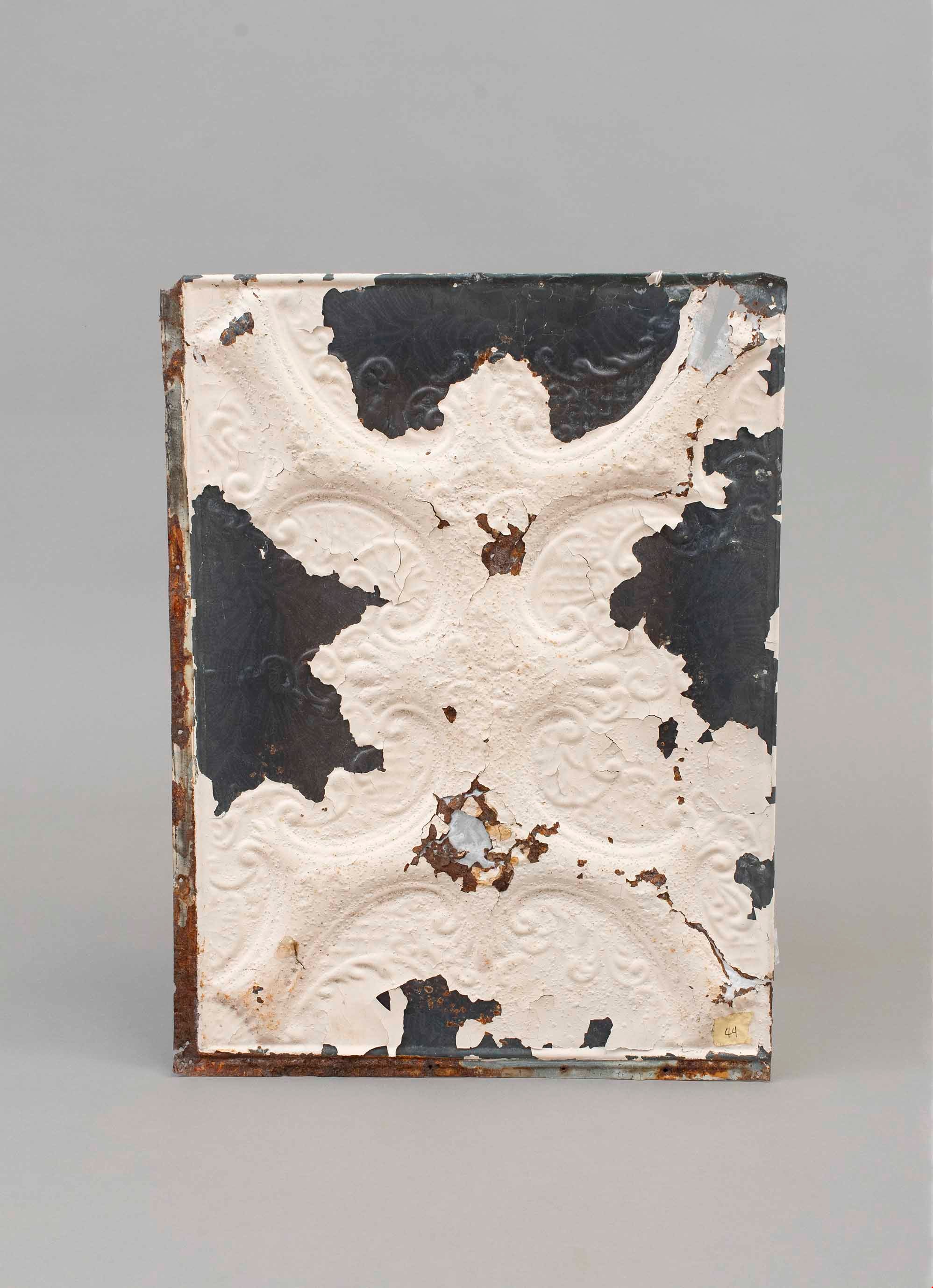
ceiling panel
https://search.heritageburnaby.ca/link/museumartifact81706
- Repository
- Burnaby Village Museum
- Accession Code
- BV988.33.111
- Description
- A single pressed metal ceiling panel with a raised scroll pattern motif. White paint is flaking from the face. There are four large areas (one on each edge) without paint. There are a number of rust holes with fiber backing as an experiment at repair There is heavy rusting on the edges and the back.
- The number "44" is written on a piece of masking tape on the face of the panel.
- Object History
- This item was taken from Love farmhouse.
- Measurements
- The panel is 45 cm X 60 cm.
- Geographic Access
- Cumberland Street
- Historic Neighbourhood
- East Burnaby (Historic Neighbourhood)
Images
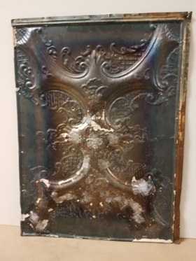
ceiling panel
https://search.heritageburnaby.ca/link/museumartifact81709
- Repository
- Burnaby Village Museum
- Accession Code
- BV988.33.114
- Description
- A single pressed metal ceiling panel with a raised scroll pattern motif(?). White paint is almost all flaked from the face. There is heavy rust on the back of the panel and fiber tape has been used to reinforce the surface.
- The number "33" is written on a piece of masking tape on the back of the panel.
- Object History
- This item was taken from Love farmhouse.
- Measurements
- The panel is 45 cm X 60 cm.
- Geographic Access
- Cumberland Street
- Historic Neighbourhood
- East Burnaby (Historic Neighbourhood)
Images


Charles R. Shaw House
https://search.heritageburnaby.ca/link/landmark525
- Repository
- Burnaby Heritage Planning
- Description
- The Charles R. Shaw House is a one and one-half storey plus basement wood-frame late Victorian era residence, located on the grounds of the Normanna Rest Home development in East Burnaby, near its original location on this site. Originally a modest vernacular Victorian structure, it has been enlarg…
- Associated Dates
- 1891
- Formal Recognition
- Heritage Designation, Community Heritage Register
- Other Names
- Charles R. & Mary Shaw House
- Street View URL
- Google Maps Street View
- Repository
- Burnaby Heritage Planning
- Other Names
- Charles R. & Mary Shaw House
- Geographic Access
- 12th Avenue
- 4th Street
- 13th Avenue
- Associated Dates
- 1891
- Formal Recognition
- Heritage Designation, Community Heritage Register
- Enactment Type
- Bylaw No. 10739
- Enactment Date
- 06/04/1998
- Description
- The Charles R. Shaw House is a one and one-half storey plus basement wood-frame late Victorian era residence, located on the grounds of the Normanna Rest Home development in East Burnaby, near its original location on this site. Originally a modest vernacular Victorian structure, it has been enlarged and embellished through later additions.
- Heritage Value
- The Shaw House is one of the oldest surviving houses in Burnaby, and is valued as a representation of a typical vernacular pioneer house in Burnaby, and a rare survivor from the late Victorian era. The original portion of the house displays a simplicity of form and detail consistent with early local construction, while the later additions display a more sophisticated approach. Originally built in 1891, this house is valued for its association with first owner, Charles R. Shaw (1834-1916) and Mary D. Shaw (1848-1897), one of Burnaby’s earliest settlers. Born in England, Shaw immigrated to Toronto in 1869, and relocated to New Westminster in 1889, where he worked as an employee of the Mechanic's Mill Company, an early woodworking plant. After moving to Burnaby, he was unanimously elected by acclamation as first reeve (mayor) of the new municipality in 1892. In 1894, Shaw sold his house and farm and moved his family to Kamloops due to his wife Mary's failing health. After Mary died in 1897, the Shaw family returned to Toronto. The Shaw House is additionally valued for its association with a later owner, James Brookes (1884-1953), founder of James Brookes Woodworking Ltd., a mill that was a major employer in East Burnaby. Brookes bought and renovated the house in 1917. In 1927, he built a much larger house on the property (now demolished), and the original house was moved to the corner of the property to serve as a gardener's cottage for Brookes' estate. The additions made to the house at this time employed sash and milled products produced by the Brookes plant. Although altered, this Victorian era residence remains largely intact, with Brookes’s later additions.
- Defining Elements
- Key elements that define the heritage character of the Shaw House include its: - modest vernacular residential form, scale and massing, as exemplified by its one and one-half storey plus basement height, front gabled roof, shed roofed verandah and asymmetrical plan - asymmetrical front entrance - cladding: horizontal wooden drop siding on the original portion of the house; cedar shingles on additions; decorative octagonal cedar shingles in the front gable; original decorated bargeboards at front, with cut-out details - later renovations to the front verandah and side addition which resulted in a partially glazed porch entrance and addition with large window assemblies - square verandah columns - irregular fenestration: double-hung wooden-sash windows in a variety of configurations such as 6-over-1 and 4-over-1 windows in the original portion of the house, 12-over-1 windows, and one 24-over-1 window in the front addition - small window at front entry - fifteen-pane French front entry door - internal red brick chimney with corbelled cap
- Historic Neighbourhood
- East Burnaby (Historic Neighbourhood)
- Planning Study Area
- Edmonds Area
- Function
- Primary Historic--Single Dwelling
- Primary Current--Single Dwelling
- Community
- Burnaby
- Cadastral Identifier
- 003-253-848
- Boundaries
- The Shaw House is comprised of a single residential lot located at 7725 Fourth Street (legal address), Burnaby
- Area
- 9199.27
- Contributing Resource
- Building
- Ownership
- Private
- Names
- Shaw, Charles R
- Street Address
- 7725 4th Street
- Street View URL
- Google Maps Street View
Images


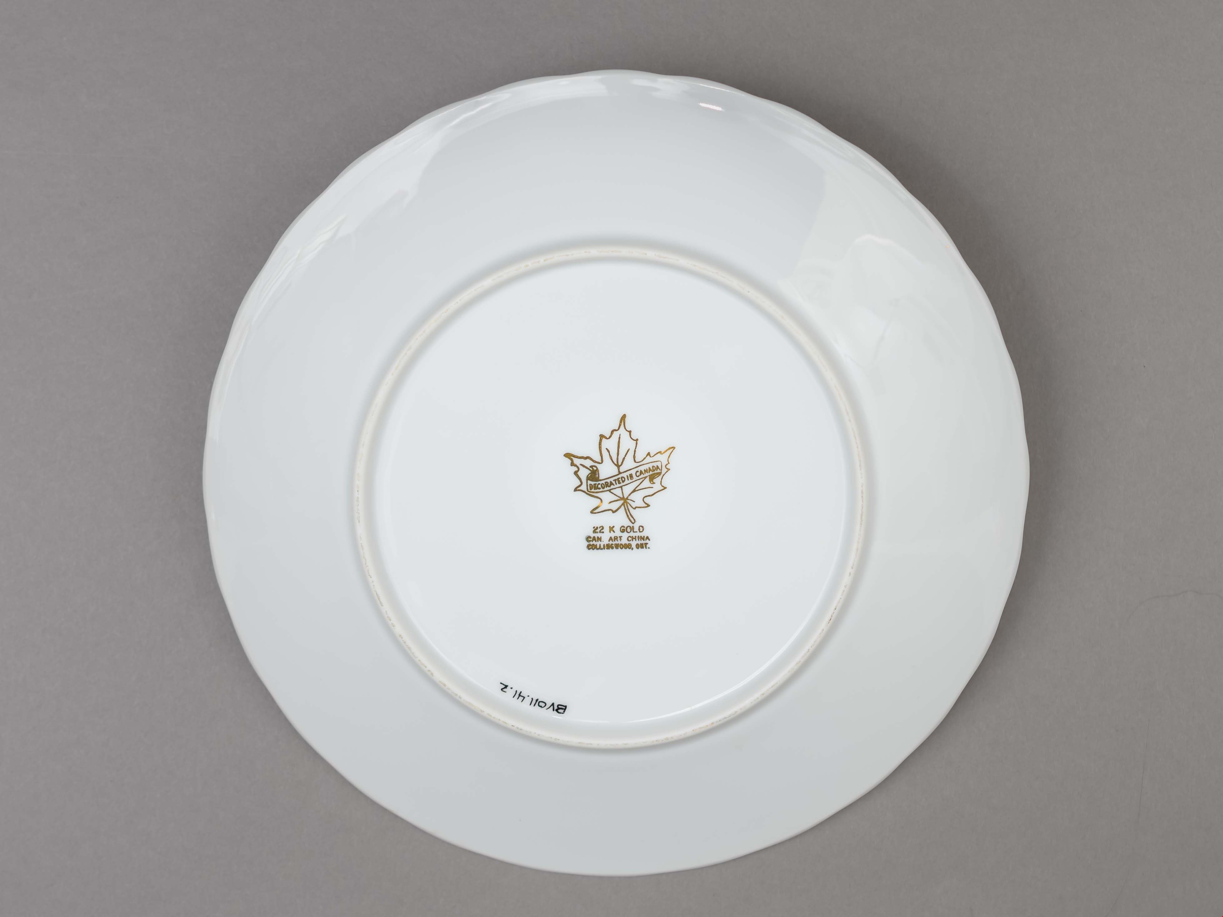
commemorative plate
https://search.heritageburnaby.ca/link/museumartifact83636
- Repository
- Burnaby Village Museum
- Accession Code
- BV011.41.2
- Description
- Souvenir plate. Celebrating the 75th Anniversary of St. Stephen the Martyr, Anglican Church. It is a white ceramic plate with a gold edge. An image of the church is in the centre of the plate. The makers logo is on the bottom of the plate. "The Anglican Church of St. Stephen the Martyr / Burnaby, B.C. / 1913 - 1988"printed on the face of the plate in gothic letters. "DECORATED IN CANADA / 22 K GOLD / CAN. ART CHINA / COLLINGWOOD, ONT." text is printed in gold over and around a maple leaf logo.
- Object History
- plate is from the St. Stephen's, Anglican Church in East Burnaby.
- Category
- 08. Communication Artifacts
- Classification
- Documentary Artifacts - - Memorabilia
- Object Term
- Commemorative
- Country Made
- Canada
- Province Made
- Ontario
- Site/City Made
- Collingwood
- Historic Neighbourhood
- East Burnaby (Historic Neighbourhood)
Images

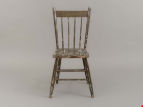
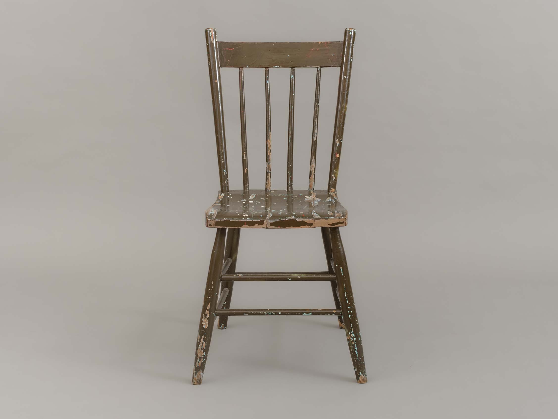
dining chair
https://search.heritageburnaby.ca/link/museumartifact90002
- Repository
- Burnaby Village Museum
- Accession Code
- BV019.8.15
- Description
- dining chair; side chair; brown painted wood; chair back has four vertical spindles; two horizontal stretchers between front and side legs; one horizontal stretcher between back legs.
- Object History
- Object used in the dining room of the Love farmhouse. The layers of paint beneath the brown outer layer reveal past colours of the chair that are documented in BVM photographs of the interior of the Love farmhouse.
- Category
- 02. Furnishings
- Classification
- Furniture - - Seating Furniture
- Object Term
- Chair
- Subjects
- Furniture
- Geographic Access
- Cumberland Street
- Street Address
- 7651 Cumberland Street
- Historic Neighbourhood
- East Burnaby (Historic Neighbourhood)
- Planning Study Area
- Cariboo-Armstrong Area
Images
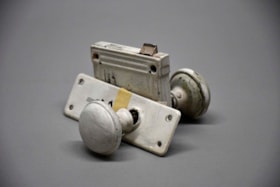
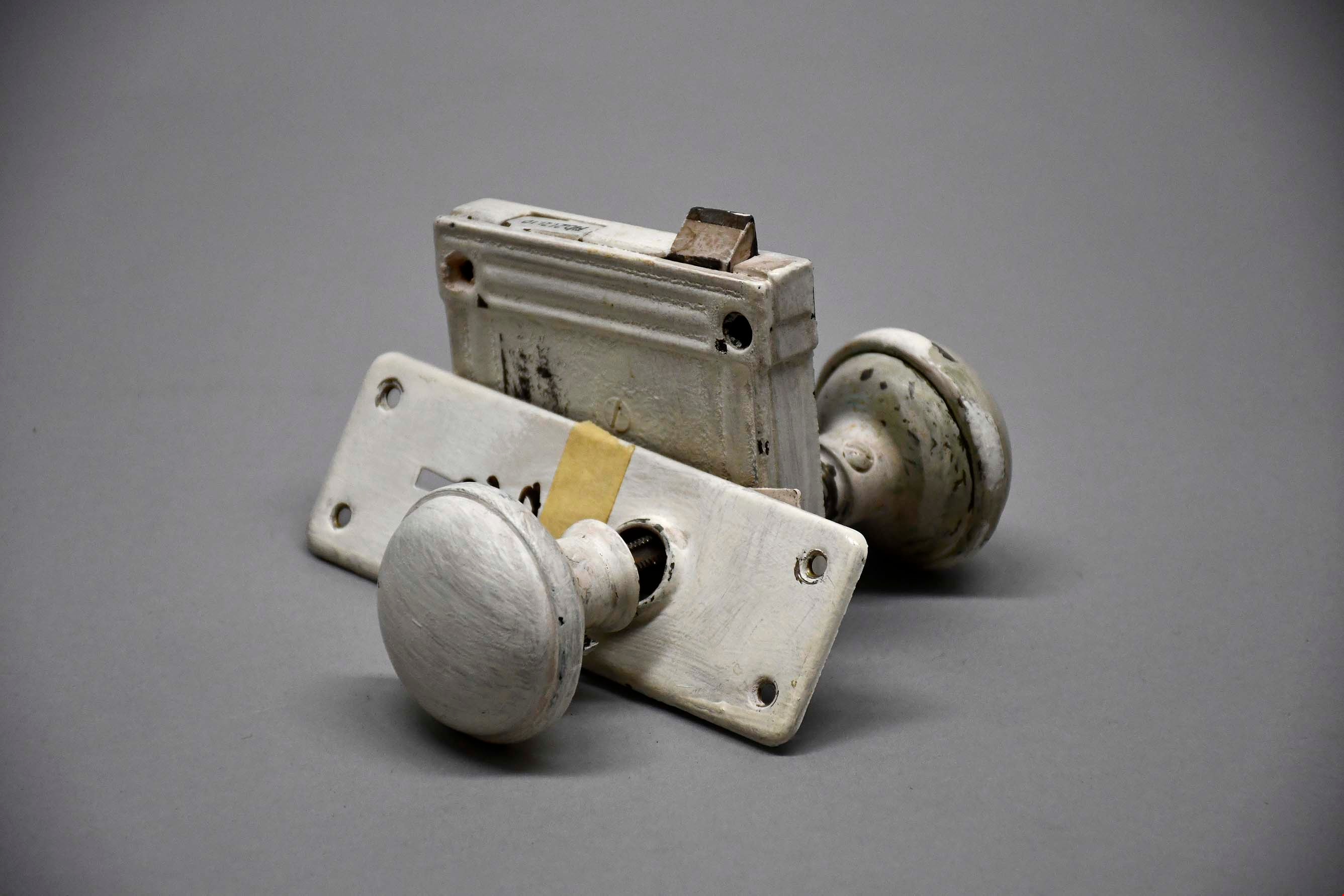
door knob
https://search.heritageburnaby.ca/link/museumartifact91300
- Repository
- Burnaby Village Museum
- Accession Code
- BV021.21.10
- Description
- Both of the knobs and the other exterior parts of the fixture are painted white, including mounting plates backing both knobs. The two knob fixtures are attached by long rectangular bar, with divots on each side. On the smaller of the two mount plates, the label "D14" is written in black marker, likely indicating the fixture's original location in the house.
- Object History
- This object was found in the attic of Love Farmhouse August 2021, where it had been since the completion of the Love Farmhouse project in the late 1990's. This doorknob was originally used in one of the doors upstairs in the farmhouse.
- Category
- 01. Built Environment Objects
- Classification
- Building Components - - Door & Window Elements
- Object Term
- Doorknob
- Colour
- White
- Measurements
- height: 9.5 cm width: 15.5 cm depth: 16 cm
- Country Made
- Canada
- Province Made
- British Columbia
- Site/City Made
- Burnaby
- Subjects
- Household Accessory
- Names
- Love Family
- Historic Neighbourhood
- East Burnaby (Historic Neighbourhood)
Images
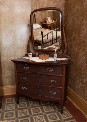
dresser
https://search.heritageburnaby.ca/link/museumartifact3362
- Repository
- Burnaby Village Museum
- Accession Code
- BV989.42.1
- Description
- Mahogany dresser C. 1920; donor plaque affixed to upper right hand drawer per curator; rectangular mirror with beveled edge is attached to curved brackets which extend up from back of dresser, can be tilted; two small drawers at top, two full-width ones below; all drawers have keyholes but plate is missing from upper right drawer
- Object History
- The mahogany dresser was donated by Gordon Love, son of John Leonard Love and also grandson of Jesse Love. The dresser was used in the Love farmhouse by Jesse's wife Martha Love. The dresser might have been part of John Leonard Love's inheritance when Jesse Love passes away. The handles on the dresser were replaced at some time with modern hardware. The hardware was replaced with more appropriate hardware for the 1920 time period. The dresser is located in the master bedroom of the Love farmhouse.
- Category
- 02. Furnishings
- Classification
- Furniture - - Storage & Display Furniture
- Object Term
- Dresser
- Subjects
- Furniture
- Geographic Access
- Cumberland Street
- Historic Neighbourhood
- East Burnaby (Historic Neighbourhood)
Images


East Burnaby Neighbourhood
https://search.heritageburnaby.ca/link/landmark773
- Repository
- Burnaby Heritage Planning
- Associated Dates
- 1905-1924
- Heritage Value
- According to the 1911 December 26 edition of The British Columbian: Optimism is the word that applies to the whole community of East Burnaby. The many improvements carried out by the council during the past two years had been the means of making East Burnaby a thriving settlement, and hence one and all are optimistic as to its future. In the clearing and building line, many fine new homes are being erected...Real estate values have advanced with the times, and a notable feature is the number of better-class houses that are being built in this locality, which proves that East Burnaby is becoming very much alive and elevated.
- Historic Neighbourhood
- East Burnaby (Historic Neighbourhood)
- Planning Study Area
- Edmonds Area
Images
