Narrow Results By
Creator
- Aitkenhead, May 1
- British Columbia Underwriters' Association 8
- Burnaby Village Museum 1
- Damer, Eric 1
- McAllister, Kenneth "Ken" 1
- McGeachie, Ivy Ashliegh 1
- Plan Department, British Columbia Insurance Underwriters' Association 8
- Stanley, Esther Love 1
- Stride, Charles Edgar 1
- Walker, Bea 1
- Wilson, Fraser 1
![Easthope photograph album, [between 1930 and 1970] thumbnail](/media/Hpo/_Data/_Archives_Images/_Unrestricted/451/451-039.jpg?width=280)
Easthope photograph album
https://search.heritageburnaby.ca/link/archivedescription97972
- Repository
- City of Burnaby Archives
- Date
- [between 1930 and 1970]
- Collection/Fonds
- Burnaby Historical Society fonds
- Description Level
- File
- Physical Description
- 40 photographs : b&w on 8 album pages : 22 cm x 30 cm
- Scope and Content
- George and Dorothy Easthope photograph album. Album includes photographs of the couple on holiday, with family and pets, and building their home at 6671 Halifax Street in Burnaby, BC.
- Repository
- City of Burnaby Archives
- Date
- [between 1930 and 1970]
- Collection/Fonds
- Burnaby Historical Society fonds
- Subseries
- Easthope family subseries
- Physical Description
- 40 photographs : b&w on 8 album pages : 22 cm x 30 cm
- Description Level
- File
- Record No.
- 451-039
- Access Restriction
- No restrictions
- Reproduction Restriction
- Reproduce for fair dealing purposes only
- Accession Number
- BHS2003-06
- Scope and Content
- George and Dorothy Easthope photograph album. Album includes photographs of the couple on holiday, with family and pets, and building their home at 6671 Halifax Street in Burnaby, BC.
- Media Type
- Photograph
- Notes
- Title based on contents of album
- Album is missing several photographs. These photographs may be included in 451-001:451-038.
- Geographic Access
- Halifax Street
- Street Address
- 6671 Halifax Street
- Historic Neighbourhood
- Lochdale (Historic Neighbourhood)
- Planning Study Area
- Lochdale Area
Images
![Easthope photograph album, [between 1930 and 1970] thumbnail](/media/Hpo/_Data/_Archives_Images/_Unrestricted/451/451-039.jpg)
![W.F. Silver house, [1931] (date of original), copied 1986 thumbnail](/media/hpo/_Data/_Archives_Images/_Unrestricted/126/173-002.jpg?width=280)
W.F. Silver house
https://search.heritageburnaby.ca/link/archivedescription35007
- Repository
- City of Burnaby Archives
- Date
- [1931] (date of original), copied 1986
- Collection/Fonds
- Burnaby Historical Society fonds
- Description Level
- File
- Physical Description
- 3 photographs : b&w panorama ; 8.8 x 12.5 cm prints
- Scope and Content
- Photograph of the William F. Silver house and surrounding lan An automobile, believed to be the family's 1927 Pierce-Arrow, is parked in front of the house. Three photographs form the panorama.
- Repository
- City of Burnaby Archives
- Date
- [1931] (date of original), copied 1986
- Collection/Fonds
- Burnaby Historical Society fonds
- Subseries
- Silver family subseries
- Physical Description
- 3 photographs : b&w panorama ; 8.8 x 12.5 cm prints
- Description Level
- File
- Record No.
- 173-002
- Access Restriction
- No restrictions
- Reproduction Restriction
- No known restrictions
- Accession Number
- BHS1986-22
- Scope and Content
- Photograph of the William F. Silver house and surrounding lan An automobile, believed to be the family's 1927 Pierce-Arrow, is parked in front of the house. Three photographs form the panorama.
- Media Type
- Photograph
- Notes
- Title based on contents of photograph
- 1 b&w photocopy of entire panorama in accession file. Digital scan is of the photocopy.
- Geographic Access
- Kingsway
- Silver Avenue
- Historic Neighbourhood
- Central Park (Historic Neighbourhood)
- Planning Study Area
- Maywood Area
Images
![W.F. Silver house, [1931] (date of original), copied 1986 thumbnail](/media/hpo/_Data/_Archives_Images/_Unrestricted/126/173-002.jpg)

Agricultural and floral societies' papers
https://search.heritageburnaby.ca/link/archivedescription57952
- Repository
- City of Burnaby Archives
- Date
- 1922 (date of original) -1970
- Collection/Fonds
- Burnaby Historical Society fonds
- Description Level
- File
- Physical Description
- 1 file of textual records and 1 photograph : b&w ; 8.5 cm x 8 cm
- Scope and Content
- File consists of miscellaneous promotional materials and certificates pertaining to agricultural and floral societies in British Columbia, including the Burnaby Rhododendron Society. File also contains one photograph a display at an agricultural fair.
- Repository
- City of Burnaby Archives
- Date
- 1922 (date of original) -1970
- Collection/Fonds
- Burnaby Historical Society fonds
- Subseries
- Bancroft family subseries
- Physical Description
- 1 file of textual records and 1 photograph : b&w ; 8.5 cm x 8 cm
- Description Level
- File
- Record No.
- MSS030-001
- Access Restriction
- No restrictions
- Reproduction Restriction
- May be restricted by third party rights
- Accession Number
- BHS1986-44
- Scope and Content
- File consists of miscellaneous promotional materials and certificates pertaining to agricultural and floral societies in British Columbia, including the Burnaby Rhododendron Society. File also contains one photograph a display at an agricultural fair.
- Media Type
- Textual Record
- Photograph
- Notes
- Title based on contents of file
Images

![Dedication of War Memorial Fountain at Burnaby Municipal Hall, [1923] thumbnail](/media/hpo/_Data/_BVM_Images/1985/1985_3137_0007_001.jpg?width=280)
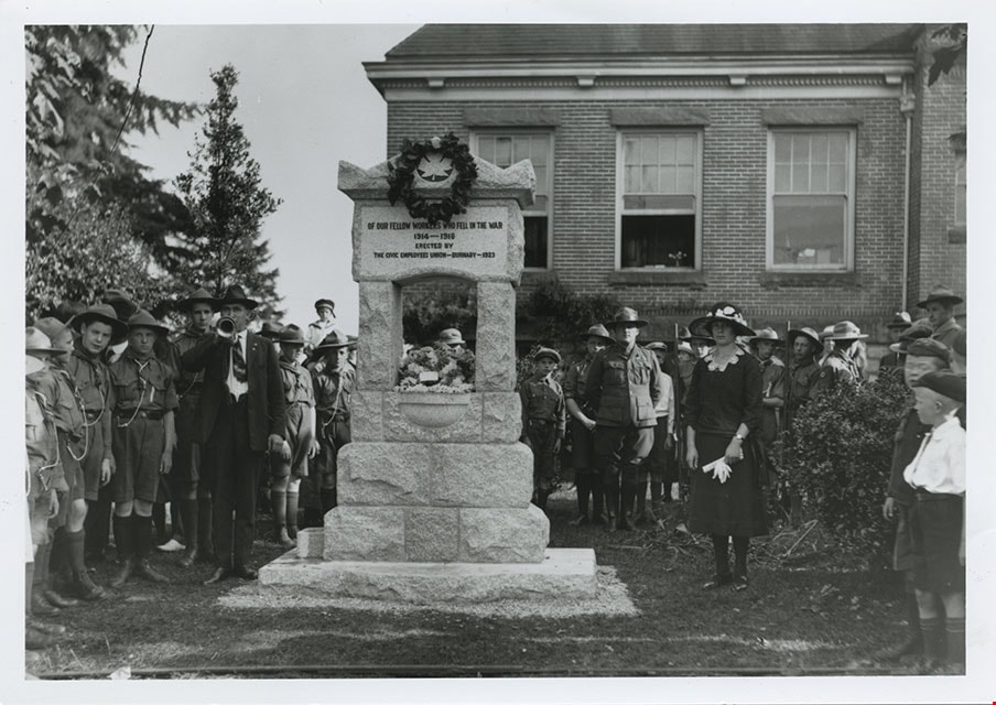
Dedication of War Memorial Fountain at Burnaby Municipal Hall
https://search.heritageburnaby.ca/link/museumdescription237
- Repository
- Burnaby Village Museum
- Date
- [1923]
- Collection/Fonds
- Burnaby Village Museum Photograph collection
- Description Level
- File
- Physical Description
- 2 photographs : b&w prints
- Scope and Content
- Photographs of the War Memorial Fountain located on the lawn of Burnaby Municipal Hall, during its dedication ceremony. There is a large crowd of people gathered around the fountain, with boys in scout uniforms standing to the right of the fountain, and ladies and RCMP officers standing to the left…
- Repository
- Burnaby Village Museum
- Collection/Fonds
- Burnaby Village Museum Photograph collection
- Description Level
- File
- Physical Description
- 2 photographs : b&w prints
- Material Details
- inscribed in the original negative, and printed on the photograph, l.r. "Stride Photo"
- Scope and Content
- Photographs of the War Memorial Fountain located on the lawn of Burnaby Municipal Hall, during its dedication ceremony. There is a large crowd of people gathered around the fountain, with boys in scout uniforms standing to the right of the fountain, and ladies and RCMP officers standing to the left side of the fountain. There is a man standing next to the fountain, blowing on a trumpet. There is a wreath hanging from the top of the fountain, which bears the inscription, "OF OUR FELLOW WORKERS WHO FELL IN THE WAR/ 1914-1918/ ERECTED BY/ THE CIVIC EMPLOYEES UNION - BURNABY - 1923" The War Memorial Fountain is now located in the Burnaby Village Museum site.
- Subjects
- Ceremonies
- Monuments - War Memorials
- Wars - World War, 1914-1918
- Fountains
- Persons - Crowds
- Names
- Burnaby City Hall
- Geographic Access
- Kingsway
- Street Address
- 7282 Kingsway
- Accession Code
- BV985.3137.7
- Reproduction Restriction
- May be restricted by third party rights
- Date
- [1923]
- Media Type
- Photograph
- Historic Neighbourhood
- Edmonds (Historic Neighbourhood)
- Planning Study Area
- Stride Avenue Area
- Scan Resolution
- 600
- Scan Date
- 2024-02-02
- Photographer
- Stride, Charles Edgar
- Notes
- Title based on contents of photograph
- 1 b&w copy negative accompanying
Images
![Dedication of War Memorial Fountain at Burnaby Municipal Hall, [1923] thumbnail](/media/hpo/_Data/_BVM_Images/1985/1985_3137_0007_001.jpg)

Florence Hart Godwin photograph album
https://search.heritageburnaby.ca/link/museumdescription3049
- Repository
- Burnaby Village Museum
- Date
- 1893-1923 (date of original), copied 1976
- Collection/Fonds
- Florence Hart Godwin fonds
- Description Level
- File
- Physical Description
- 1 album (29 photographs: b&w negatives ; 35 mm)
- Scope and Content
- File consists of a photographic reproduction of a twenty nine page photograph album that was created by Florence Hart Godwin. The first page of the album reads "Florence, with Grandma's and Auntie Felicia's best love, Xmas 1910" and the other pages contain photographs. The album was given to Flore…
- Repository
- Burnaby Village Museum
- Collection/Fonds
- Florence Hart Godwin fonds
- Description Level
- File
- Physical Description
- 1 album (29 photographs: b&w negatives ; 35 mm)
- Scope and Content
- File consists of a photographic reproduction of a twenty nine page photograph album that was created by Florence Hart Godwin. The first page of the album reads "Florence, with Grandma's and Auntie Felicia's best love, Xmas 1910" and the other pages contain photographs. The album was given to Florence Hart for Christmas in 1910, by her grandmother Jane Chapman (nee Isbell) and her Aunt Felicia Chapman. Album contains photographs of the Alice and Frederick J. Hart and Chapman families, including childhood photographs of the five Hart children, Kingsley, Florence, Fredricka, Edwyna and Jack; the Hart family at their home in New Westminster and at "Avalon" their summer residence and home on Deer Lake.
- Names
- Godwin, Florence Hart
- Accession Code
- HV976.168.1
- Access Restriction
- No restrictions
- Reproduction Restriction
- No known restrictions
- Date
- 1893-1923 (date of original), copied 1976
- Media Type
- Photograph
- Textual Record
- Scan Resolution
- 600
- Scan Date
- 2023-07-24
- Notes
- Title based on contents of photograph album
- 29 b&w copy prints accompanying
- Item level descriptions available per album page
Images

Documents
![Political photographs, [1938-1990], predominant 1938-1953 thumbnail](/media/hpo/_Data/_BVM_Images/2013/2013_0012_0006_001.jpg?width=280)
Political photographs
https://search.heritageburnaby.ca/link/museumdescription3649
- Repository
- Burnaby Village Museum
- Date
- [1938-1990], predominant 1938-1953
- Collection/Fonds
- Harold Edward Winch collection
- Description Level
- File
- Physical Description
- 35 photographs : b&w + col. prints + slides
- Scope and Content
- File consists of photographs relating to Winch's political career, including professional portraits of Harold Winch, tourist photographs of Ottawa, and photographs of Winch with New Democratic Party (NDP) colleagues Dave Barrett (Premier of British Columbia, 1972-1975; also served as MLA and MP) an…
- Repository
- Burnaby Village Museum
- Collection/Fonds
- Harold Edward Winch collection
- Description Level
- File
- Physical Description
- 35 photographs : b&w + col. prints + slides
- Scope and Content
- File consists of photographs relating to Winch's political career, including professional portraits of Harold Winch, tourist photographs of Ottawa, and photographs of Winch with New Democratic Party (NDP) colleagues Dave Barrett (Premier of British Columbia, 1972-1975; also served as MLA and MP) and Dave Stupich (served as MLA and MP). Includes a photograph taken by photographer Ken McAllister of members of the CCF (Co-operative Commonwealth Federation) standing outside of the British Columbia Legislature [ca. 1941].
- Subjects
- Government - Federal Government
- Accession Code
- BV013.12.6
- Access Restriction
- No restrictions
- Reproduction Restriction
- May be restricted by third party rights
- Date
- [1938-1990], predominant 1938-1953
- Media Type
- Photograph
- Scan Resolution
- 600
- Scan Date
- 2023-04-14
- Photographer
- McAllister, Kenneth "Ken"
- Notes
- Title based on contents of file
- Annotation in blue ink on recto of photograph of CCF members [ca. 1941] includes names of people identified; "Arthur Tuenue, Colin Cameron, Laura Jamieson, Grant MacNeil / Wallis Lefeaux, Sam Guthrie, Bernard Webber, / Front: Bert Herridge, Grace MacInnis, Bert Gargrave, Harold Winch, Gretchen Steeves, Len Shepherd, Ernie Winch"
Images
![Political photographs, [1938-1990], predominant 1938-1953 thumbnail](/media/hpo/_Data/_BVM_Images/2013/2013_0012_0006_001.jpg)
Girl Guiding
https://search.heritageburnaby.ca/link/museumdescription4588
- Repository
- Burnaby Village Museum
- Date
- 1939-1951
- Collection/Fonds
- Burnaby Girl Guides fonds
- Description Level
- File
- Physical Description
- 1 scrapbook album (99 photographs+ textual records + other material)
- Scope and Content
- File consists of 18 loose pages of a scrapbook created by Ivy McGeachie (nee Ivy Oldham) who was involved in guiding in Burnaby between 1942 -1948. The front page of the scrapbook is titled “Girl / Guiding” and has a wood-burnt image of a camp fire and a singed photo of a flag pole. The scrapbook …
- Repository
- Burnaby Village Museum
- Collection/Fonds
- Burnaby Girl Guides fonds
- Description Level
- File
- Physical Description
- 1 scrapbook album (99 photographs+ textual records + other material)
- Scope and Content
- File consists of 18 loose pages of a scrapbook created by Ivy McGeachie (nee Ivy Oldham) who was involved in guiding in Burnaby between 1942 -1948. The front page of the scrapbook is titled “Girl / Guiding” and has a wood-burnt image of a camp fire and a singed photo of a flag pole. The scrapbook contains photographs along with bits and pieces of ephemera. Included in the material is a four page, type-written diary of a Girl Guide camp held at Aldergrove Beach in August of 1963. Many of the photographs document the activities of the 2nd Burnaby Girl Guide Company and include photos of Ivy and Margaret McGeachie in uniform on roller skates; Burnaby District Camp (Aldergrove, BC) / 1948; Hiking; Canadian Girl Guide Golden Jubilee; Open House at St. Alban’s church hall; a hand tinted photo of Ivy McGeachie 1939 and the 2nd Kamloops Folk Dance – Yale Cariboo Musical festival 1951.
- Creator
- McGeachie, Ivy Ashliegh
- Accession Code
- BV015.35.160
- Access Restriction
- No restrictions
- Reproduction Restriction
- May be restricted by third party rights
- Date
- 1939-1951
- Media Type
- Photograph
- Textual Record
- Notes
- Title based on content of file
- Some photographs within scrapbook have been described at item level (BV015.35.191 to BV015.35.210)
Images

Documents

First Burnaby Company
https://search.heritageburnaby.ca/link/museumdescription4590
- Repository
- Burnaby Village Museum
- Date
- 1934-1939
- Collection/Fonds
- Burnaby Girl Guides fonds
- Description Level
- File
- Physical Description
- 1 scrapbook (2 photographs + illustrations + textual records)
- Scope and Content
- File consists of a scrapbook with sixteeen double sided pages with handwritten journal notations, poems, hand drawn illustrations and photographs documenting 1st Burnaby Girl Guide activities including meetings, hiking, camping and various outings. Many of the journal entries describe hiking around…
- Repository
- Burnaby Village Museum
- Collection/Fonds
- Burnaby Girl Guides fonds
- Description Level
- File
- Physical Description
- 1 scrapbook (2 photographs + illustrations + textual records)
- Scope and Content
- File consists of a scrapbook with sixteeen double sided pages with handwritten journal notations, poems, hand drawn illustrations and photographs documenting 1st Burnaby Girl Guide activities including meetings, hiking, camping and various outings. Many of the journal entries describe hiking around Burnaby including areas such as Deer Lake, Brunette River, Willingdon and the Gilley Avenue Ravine while photographs document a garden party at the Municipal Hall at Edmonds in 1936. Photograph BV015.35.162.1 is titled "Garden Party / 1936" with Brown Owls identified L to R as: Mrs. Gowan, Miss May Dumas and Miss Kay Crossfield. Photograph BV015.35.162.2 is titled " Folk-dancing team / 1936 / Garden Party, Municipal Hall, Edmonds" with people identified in the top row L to R as: Phyllis Lockhart, Margaret Wilson, Marion Bellinger, Betty Martin and Peggy Urquhart and bottom row L to R as: Joan Warburton, Kay Lambert and Joan Mortimer. The scrapbook may have been a collective project by Marion Bellinger, Jean Atcheson, Margaret Wilson and Connie Benning.
- Names
- Atcheson, Jean
- Wilson, Margaret
- Bellinger, Marion
- Dumas, May
- Crossfield, Kay
- Lockhart, Phyllis
- Martin, Betty
- Urquhart, Peggy
- Warburton, Joan
- Lambert, Kay
- Mortimer, Joan
- Girl Guides of Canada
- Accession Code
- BV015.35.162
- Access Restriction
- No restrictions
- Reproduction Restriction
- May be restricted by third party rights
- Date
- 1934-1939
- Media Type
- Photograph
- Textual Record
- Graphic Material
- Notes
- Title based on contents of scrapbook
- Two photographs are described at item level (BV015.35.162.1 & BV015.35.162.2)
Images

Documents
![Burnaby Girl Guides, [1914]-1969, predominant ca. 1920 (date of original), copied 2016 thumbnail](/media/hpo/_Data/_BVM_Images/2015/2015_0035_0164_folded.jpg?width=280)
Burnaby Girl Guides
https://search.heritageburnaby.ca/link/museumdescription4592
- Repository
- Burnaby Village Museum
- Date
- [1914]-1969, predominant ca. 1920 (date of original), copied 2016
- Collection/Fonds
- Burnaby Girl Guides fonds
- Description Level
- File
- Physical Description
- 1 scrapbook (textual records + 2 digital files : (pdfs) + 102 photographs : (tiffs))
- Scope and Content
- File consists of images and selected contents from a scrapbook with 38 double sided pages containing mostly photographs with some newspaper clippings, written material and emphemera including a page of badges and ribbons which reads "Enrolment & Membership Card of / Joan Bailey 1926 / 1st Burnaby" …
- Repository
- Burnaby Village Museum
- Collection/Fonds
- Burnaby Girl Guides fonds
- Description Level
- File
- Physical Description
- 1 scrapbook (textual records + 2 digital files : (pdfs) + 102 photographs : (tiffs))
- Scope and Content
- File consists of images and selected contents from a scrapbook with 38 double sided pages containing mostly photographs with some newspaper clippings, written material and emphemera including a page of badges and ribbons which reads "Enrolment & Membership Card of / Joan Bailey 1926 / 1st Burnaby" and an embroidered alphabet of the Morse Code. The third page of the scrapbook includes a four page chronology titled "History of Guiding - Burnaby / 1913 - 1960" compiled by Mrs. Dolly Weber, Mrs. J. Heaps, Miss Eileen Periton, Mrs. J. Albertson and D. Fowler. The scrapbook also includes an original letter and post-script from Lady Olave Baden-Powell to Mrs. Fowler dated November 5, 1961; a typewritten copy of: "TSOONA" / PROVINCIAL GUIDE CAMPSITE - ROSEDALE B.C." and a three page typewritten copy of "THE CAMPFIRE / Volume 1, No. 4 _ November 1935 _ Vancouver, B.C.". Many of the events documented in photographs [between 1914 and 1969] are identified on each page and read as the following: "Burnaby Brownies - Guides & Rangers" / "Early 1920" (1 photograph); "Ambulance / Display / 1st. Co."; "Girl Guide Rally - New Westminster and / Burnaby - June 16, 1923" (5 photographs); "Girl Guide Rally - New Westminster and / Burnaby - June 16, 1923" (5 photographs); "Burnaby Guides and / Brownies / June 17, 1923" (5 photographs); "April 1923" (1 photograph); "June 1923 / 2nd Burnaby Company" (1 photograph); "Burnaby May Day / 26.5.28"(2 photographs); "Sechelt 1929_ 2nd "B" Company" (2 photographs); "Leaders and Seconds / 2nd Burnaby / Grouse Mountain" (1 photograph); "Sechelt 1929 / Commandant Mrs. Peal" (1 photograph); "2nd Company / June 1930" (1 photograph); "1932 / 2nd Company at Rally / Municipal Hall Grounds" (1 photograph) ; "First Burnaby Folk Dancing team / Winners of the E.F.D. cup 1940--41-42" (1 photograph); "1st Burnaby Company / winners of Bessborough Shield / 1942 / Captain L. Crane" (1 photograph); "May 6th 1935 / Dedication of flag at Central Park" (1 photograph); "May Day Celebration / Burnaby B.C. May 6th 1935 / Stride Studios Photos" (1 photograph); "Mrs. Don Wilks / Mrs. Georgie / Runcie / Publicity Photo re- / Brownie / Training / 1958-60" (1 photograph); "Kathleen Anderson / about 1958-60?" (1 photograph); "1957 / Burnaby Camp Site / at / Wilson Creek" (1 photograph); "Work Party (1958)" (1 photograph); "Burnaby Camp Site / Spring 1958 / Cabins & Staff Houses / Dining Shelter / Cabins" (3 photographs); "Can. Girl Guide Assoc. - Provincial Leaders Conference / April 14-15/61 Civic Centre, Prince George, BC" (1 photograph) ; "June 8th, 1958 / Opening / Ceremonies / Burnaby Site / Wilson Creek / Camp Site" (4 photographs); 2 unidentified photographs [ca.1915] of a large group of Girl Guides gathered on the Pacific National Exhibition grounds (photo credit- Leonard Frank); 1 unidentified photograph of a group of Girl Guides gathered for a group portrait [ca.1914]; "Girl Guide Camp / Granthams / Landing / July 1923" (4 photographs); 4 unidentified photographs of girl guides gathered on the ship "Lady Evelyn" [ca. 1920]; "Burnaby Girl Guides" 1918; "First Burnaby Girl Guides 1920" (2 photographs on page); "2nd Co. 1923" (1 photograph) "1st Burnaby Co." [1923] (1 photograph); "Gypsy Scene - Concert / Mar 17, 1923 / Unveiling / War / Memorial / Edmonds / 1923" (3 photographs on page); "Faith Jacobson / 1961" (2 photographs); "Eve MacLean / 1961" (1 photograph); "Beverley Simkin of Montreal and Judy Robins / of the S.R.S. Royal Oak taken on the day they / sailed from Montreal for the Ranger Camp at / "Our Chalet" in Adelboden, Switzerland, May 1962" (1 photograph) and "Religion & Life Emblem / Diane Peters 11th Bby. Co. / Rev. G.W. Luetkehodeter / 1961" (2 photographs on one page).
- Names
- Girl Guides of Canada
- Accession Code
- BV015.35.164
- Access Restriction
- No restrictions
- Reproduction Restriction
- May be restricted by third party rights
- Date
- [1914]-1969, predominant ca. 1920 (date of original), copied 2016
- Media Type
- Photograph
- Textual Record
- Historic Neighbourhood
- Edmonds (Historic Neighbourhood)
- Central Park (Historic Neighbourhood)
- Planning Study Area
- Edmonds Area
- Maywood Area
- Notes
- Transcribed title
- Digital images were created of the scrapbook prior to selective retention of original records that were removed for conservation purposes
- Some textual records that were selected for retention have been described at file level under BV015.35.164: "Tsoona" Provincial Guide Campsite - Rosedale B.C." and Burnaby Girl Guides newsletter, "The Campfire" (November 1935)
- Photographs that were retained from scrapbook have been described at item level (BV015.35.221 to BV015.35.284)
- Some textual records and ephemera that were selected for retention have been described at item level (BV015.35.320, BV015.35.321, and BV015.35.334 to BV015.35.348).
Images
![Burnaby Girl Guides, [1914]-1969, predominant ca. 1920 (date of original), copied 2016 thumbnail](/media/hpo/_Data/_BVM_Images/2015/2015_0035_0164_folded.jpg)
Documents
![50th Anniversary G.G.C., [1926-1979] thumbnail](/media/hpo/_Data/_BVM_Images/2015/2015_0035_0166_folded_redacted.jpg?width=280)
50th Anniversary G.G.C.
https://search.heritageburnaby.ca/link/museumdescription4594
- Repository
- Burnaby Village Museum
- Date
- [1926-1979]
- Collection/Fonds
- Burnaby Girl Guides fonds
- Description Level
- File
- Physical Description
- 1 scrapbook (51 photographs + 1 postcard + textual records)
- Scope and Content
- File consists of a scrapbook with a handpainted wood cover titled "50th Anniversary / G.G.C". The scrapbook documents events and ceremonies of the 4th Guide Company with the first half of the scrapbook containing photographs and documents regarding the 50th Anniversary of Girl Guides which was cele…
- Repository
- Burnaby Village Museum
- Collection/Fonds
- Burnaby Girl Guides fonds
- Description Level
- File
- Physical Description
- 1 scrapbook (51 photographs + 1 postcard + textual records)
- Scope and Content
- File consists of a scrapbook with a handpainted wood cover titled "50th Anniversary / G.G.C". The scrapbook documents events and ceremonies of the 4th Guide Company with the first half of the scrapbook containing photographs and documents regarding the 50th Anniversary of Girl Guides which was celebrated at St. Nicholas Church in 1960 while the second half documents earlier events from 1926, as well as other events in the 1960s such as; "Year of the Golden Jubilee", a parade in North Burnaby as well as Thinking Day 1976-1978, banquets, a disco contest, camping on Hollyburn mountain and a visit to Victoria in 1979. On November 3rd, 1926 the company was registered as the 5th Burnaby Guide company, in 1951 the number was changed to the 4th Vancouver Guide Company and in 1956 the number was changed to the 4th Burnaby Company.
- Accession Code
- BV015.35.166
- Access Restriction
- No restrictions
- Reproduction Restriction
- May be restricted by third party rights
- Date
- [1926-1979]
- Media Type
- Textual Record
- Photograph
- Notes
- Transcribed title
- Items within scrapbook have been redacted in compliance with Section 22 of FIPPA
- A selection of photographs are described at item level (BV015.35.285 to BV.015.35.300).
Images
![50th Anniversary G.G.C., [1926-1979] thumbnail](/media/hpo/_Data/_BVM_Images/2015/2015_0035_0166_folded_redacted.jpg)
Documents
![Interurban, Ceperley and Madill houses and Deer Lake, [ca. 1910] thumbnail](/media/hpo/_Data/_BVM_Images/2018/2018_0015_0003_007.jpg?width=280)
Interurban, Ceperley and Madill houses and Deer Lake
https://search.heritageburnaby.ca/link/museumdescription4622
- Repository
- Burnaby Village Museum
- Date
- [ca. 1910]
- Collection/Fonds
- Burnaby Village Museum Photograph collection
- Description Level
- File
- Physical Description
- 8 photographs : b&w ; negatives 35 mm
- Scope and Content
- File consists of photographs taken from original photographs of the Ceperley house and grounds "Fairhaven", the Madill family and house, Deer Lake, an Interurban train with "Westminster" signage on the front of the roof next to an unidentifed siding building and an unidentified two storey wood fra…
- Repository
- Burnaby Village Museum
- Collection/Fonds
- Burnaby Village Museum Photograph collection
- Description Level
- File
- Physical Description
- 8 photographs : b&w ; negatives 35 mm
- Scope and Content
- File consists of photographs taken from original photographs of the Ceperley house and grounds "Fairhaven", the Madill family and house, Deer Lake, an Interurban train with "Westminster" signage on the front of the roof next to an unidentifed siding building and an unidentified two storey wood frame house with two towers on either side of the verandah.
- Subjects
- Transportation - Electric Railroads
- Names
- Ceperley, Grace
- Accession Code
- BV018.15.3
- Access Restriction
- No restrictions
- Reproduction Restriction
- May be restricted by third party rights
- Date
- [ca. 1910]
- Notes
- Title based on content of photographs
Images
![Interurban, Ceperley and Madill houses and Deer Lake, [ca. 1910] thumbnail](/media/hpo/_Data/_BVM_Images/2018/2018_0015_0003_007.jpg)

B.C. Girl Guides
https://search.heritageburnaby.ca/link/museumdescription5234
- Repository
- Burnaby Village Museum
- Date
- 1914 -1982 (date of original), copied 2016
- Collection/Fonds
- Burnaby Girl Guides fonds
- Description Level
- File
- Physical Description
- 1 scrapbook (2 digital files (pdfs) + 39 photographs (tiffs)
- Scope and Content
- File consists of images of a scrapbook of newspaper clippings, photographs and memorabilia pertaining to guiding in Burnaby between 1930 and 1981. The scrapbook includes a photograph of the 1st Burnaby Girl Guide Company in 1914 and The Girl Guides Conference from 1950. This scrapbook was often us…
- Repository
- Burnaby Village Museum
- Collection/Fonds
- Burnaby Girl Guides fonds
- Description Level
- File
- Physical Description
- 1 scrapbook (2 digital files (pdfs) + 39 photographs (tiffs)
- Scope and Content
- File consists of images of a scrapbook of newspaper clippings, photographs and memorabilia pertaining to guiding in Burnaby between 1930 and 1981. The scrapbook includes a photograph of the 1st Burnaby Girl Guide Company in 1914 and The Girl Guides Conference from 1950. This scrapbook was often used by Paulene Hall at presentations.
- Creator
- Walker, Bea
- Names
- Girl Guides of Canada
- Accession Code
- BV016.49.83
- Access Restriction
- No restrictions
- Reproduction Restriction
- May be restricted by third party rights
- Date
- 1914 -1982 (date of original), copied 2016
- Media Type
- Photograph
- Textual Record
- Notes
- Title based on content of scrapbook
- Selective retention of original records from scrapbook
- Selected photographs were retained and described at item level : BV016.49.126 & BV016.49.96
Images

Documents
![Pages from May Aikenhead scrapbook, [1930-1935] thumbnail](/media/hpo/_Data/_BVM_Images/2015/2015_0035_0168_all_pages.jpg?width=280)
Pages from May Aikenhead scrapbook
https://search.heritageburnaby.ca/link/museumdescription5245
- Repository
- Burnaby Village Museum
- Date
- [1930-1935]
- Collection/Fonds
- Burnaby Girl Guides fonds
- Description Level
- File
- Physical Description
- 1 file of textual records : 1 p. + 1 illustration : col. ; graphite and watercolour + 1 digital file : col. (pdf) + 10 photographs : col. (tiffs)
- Scope and Content
- File consists of pages from a scrapbook created by May Aitkenhead. Pages include an illustration of a Girl Guide in uniform done in pencil and watercolour along with two pages (double sided) of clippings from newspapers, magazines and a programme. The illustration page includes the name "Mabel McIn…
- Repository
- Burnaby Village Museum
- Collection/Fonds
- Burnaby Girl Guides fonds
- Description Level
- File
- Physical Description
- 1 file of textual records : 1 p. + 1 illustration : col. ; graphite and watercolour + 1 digital file : col. (pdf) + 10 photographs : col. (tiffs)
- Scope and Content
- File consists of pages from a scrapbook created by May Aitkenhead. Pages include an illustration of a Girl Guide in uniform done in pencil and watercolour along with two pages (double sided) of clippings from newspapers, magazines and a programme. The illustration page includes the name "Mabel McIntyre / Cl. 16" handwritten in pencil at the top of the page along with a sticker of a wreath. The newspaper clippings page is titled "Guide News" and includes selected clippings about the 5th Burnaby Girl Guides, while two other pages include information titled "Patrol Portfolio Chart No. 9 _ Digging"; "The Aims of the Girl Guides" and "Girl Guiding" with photographic images of Mrs. Alan Morkill (Provincial Commissioner for British Columbia); Countess Bessborough (Honourary President of the Canadian Girl Guide Association); His Excellency Rt. Hon. the Earl of Bessborough (Governor General and Commander in Chief of the Dominion of Canada- Chief Scout of Canada) as well as Lady and Lord Baden Powell. The last page is clipped and pasted from a programme and/or poster "Grand Rally / Scouts / and / Guides / April 15th 1935 / Hastings Park / Vancouver BC" and includes a page of the programme.
- Creator
- Aitkenhead, May
- Names
- Girl Guides of Canada
- Accession Code
- BV015.35.168
- Access Restriction
- No restrictions
- Reproduction Restriction
- May be restricted by third party rights
- Date
- [1930-1935]
- Media Type
- Textual Record
- Graphic Material
- Notes
- Title based on contents of file
- Digital images were created of the scrapbook prior to selective retention of original records
- Selected pages were removed from original scrapbook and were retained under BV015.35.168
- Selected photographs were removed from scrapbook prior and are described at item level (BV015.35.292 to BV015.35.300)
Images
![Pages from May Aikenhead scrapbook, [1930-1935] thumbnail](/media/hpo/_Data/_BVM_Images/2015/2015_0035_0168_all_pages.jpg)
Documents

Municipality of Burnaby - Volume XV and Volume XVIII
https://search.heritageburnaby.ca/link/museumdescription8680
- Repository
- Burnaby Village Museum
- Date
- May 1927
- Collection/Fonds
- Burnaby Village Museum Map collection
- Description Level
- File
- Physical Description
- 4 plans on 4 sheets : col. lithographic prints ; 63.5 x 53.5 cm folded to 53 x 31.5 cm
- Scope and Content
- File consists of four pages of plans removed from a bound book containing a series of fire insurance plans of the Municipality of Burnaby. The first two pages are numbered "A" and "B" and are key plans from "GREATER VANCOUVER B.C. / VOLUME XV / Surveyed _ May 1927 / MUNICIPALITY OF / BURNABY", "PLA…
- Repository
- Burnaby Village Museum
- Collection/Fonds
- Burnaby Village Museum Map collection
- Description Level
- File
- Physical Description
- 4 plans on 4 sheets : col. lithographic prints ; 63.5 x 53.5 cm folded to 53 x 31.5 cm
- Material Details
- Scales [1:1200] and [1:6000]
- Scope and Content
- File consists of four pages of plans removed from a bound book containing a series of fire insurance plans of the Municipality of Burnaby. The first two pages are numbered "A" and "B" and are key plans from "GREATER VANCOUVER B.C. / VOLUME XV / Surveyed _ May 1927 / MUNICIPALITY OF / BURNABY", "PLAN DEPT. FIRE BRANCH _ B.C. INSURANCE UNDERWRITERS ASSN.". Key Plan "B" covers plans: 1505; 1506; 1512 to 1516; 1540 to 1544; 1550 to 1557 and District Lots: 129 to 132; 135 to 138; 205 to 208 and 215 to 218. Key Plan "A" covers plans: 1501 to 1504; 1507 to 1511; 1517 to 1525; 1531 to 1539; 1545 to 1550 and District Lots: 116 to 127 and 186 to 189. Plan "1806" is part of "GREATER VANCOUVER B.C. / VOLUME XVIII / Municipality of Burnaby / May, 1927" and covers District Lot 153. Plan "1807" is from "GREATER VANCOUVER B.C. / VOLUME XVIII / Municipality of Burnaby / May, 1927" and covers District Lots: 99,149 and 152.
- Responsibility
- British Columbia Underwriters' Association
- Accession Code
- HV972.111.2
- Access Restriction
- No restrictions
- Reproduction Restriction
- May be restricted by third party rights
- Date
- May 1927
- Media Type
- Cartographic Material
- Historic Neighbourhood
- Vancouver Heights (Historic Neighbourhood)
- Lochdale (Historic Neighbourhood)
- Capitol Hill (Historic Neighbourhood)
- Central Park (Historic Neighbourhood)
- Alta Vista (Historic Neighbourhood)
- Planning Study Area
- Burnaby Heights Area
- Sperling-Broadway Area
- Lochdale Area
- Parkcrest-Aubrey Area
- Westridge Area
- Willingdon Heights Area
- Capitol Hill Area
- Maywood Area
- Marlborough Area
- Scan Resolution
- 400
- Scan Date
- 2021-11-18
- Notes
- Title based on content of plans
- Scales are measured 1 inch = 100 feet and 1 inch = 500 feet
- See also BV987.1.70d for revised versions of plans
Zoomable Images


Municipality of Burnaby - Volume XV and Volume XVIII
https://search.heritageburnaby.ca/link/museumdescription8681
- Repository
- Burnaby Village Museum
- Date
- May 1927
- Collection/Fonds
- Burnaby Village Museum Map collection
- Description Level
- File
- Physical Description
- 4 plans on 4 sheets : col. lithographic prints, ms. annotations in blue ink ; 63.5 x 53.5 cm folded to 53 x 31.5 cm
- Scope and Content
- File consists of four pages of plans removed from a bound book containing a series of fire insurance plans of the Municipality of Burnaby. Plan "1507" and plan "1517" are from "GREATER VANCOUVER B.C. / VOLUME XV / Municipality of Burnaby / May, 1927". Plan "1507" covers District Lot 186 and plan "1…
- Repository
- Burnaby Village Museum
- Collection/Fonds
- Burnaby Village Museum Map collection
- Description Level
- File
- Physical Description
- 4 plans on 4 sheets : col. lithographic prints, ms. annotations in blue ink ; 63.5 x 53.5 cm folded to 53 x 31.5 cm
- Material Details
- Scale [1:600] and [1:1200]
- Scope and Content
- File consists of four pages of plans removed from a bound book containing a series of fire insurance plans of the Municipality of Burnaby. Plan "1507" and plan "1517" are from "GREATER VANCOUVER B.C. / VOLUME XV / Municipality of Burnaby / May, 1927". Plan "1507" covers District Lot 186 and plan "1517" covers District Lot 116. Plan "1804" and plan "1805" are from "GREATER VANCOUVER B.C. / VOLUME XVIII / Municipality of Burnaby / May, 1927". Plans "1804" and "1805" cover District Lot 153.
- Responsibility
- British Columbia Underwriters' Association
- Accession Code
- HV972.111.3
- Access Restriction
- No restrictions
- Reproduction Restriction
- May be restricted by third party rights
- Date
- May 1927
- Media Type
- Cartographic Material
- Historic Neighbourhood
- Central Park (Historic Neighbourhood)
- Vancouver Heights (Historic Neighbourhood)
- Planning Study Area
- Maywood Area
- Willingdon Heights Area
- Scan Resolution
- 400
- Scan Date
- 2021-11-18
- Notes
- Title based on content of plans
- See also BV987.1.70d for revised versions of plans
- Scale is measured 1 inch = 100 feet
Images


![Municipality of Burnaby - Volume XV and Volume XVIII, 1927-[1940] thumbnail](/media/hpo/_Data/_BVM_Artifacts/1972/1972_0111_0004_003.jpg?width=280)
Municipality of Burnaby - Volume XV and Volume XVIII
https://search.heritageburnaby.ca/link/museumdescription8682
- Repository
- Burnaby Village Museum
- Date
- 1927-[1940]
- Collection/Fonds
- Burnaby Village Museum Map collection
- Description Level
- File
- Physical Description
- 4 plans on 4 sheets: col. lithographic prints ; 63.5 x 53.5 cm folded to 53 x 31.5 cm
- Scope and Content
- File consists of four pages of plans removed from a bound book containing a series of fire insurance plans of the Municipality of Burnaby. Plan "1518" and "1519" are from "GREATER VANCOUVER B.C. / VOLUME XV / Municipality of Burnaby / May, 1927". Plan "1518" covers District Lot 116 and Plan "1519"…
- Repository
- Burnaby Village Museum
- Collection/Fonds
- Burnaby Village Museum Map collection
- Description Level
- File
- Physical Description
- 4 plans on 4 sheets: col. lithographic prints ; 63.5 x 53.5 cm folded to 53 x 31.5 cm
- Material Details
- Scale [1:600]
- Scope and Content
- File consists of four pages of plans removed from a bound book containing a series of fire insurance plans of the Municipality of Burnaby. Plan "1518" and "1519" are from "GREATER VANCOUVER B.C. / VOLUME XV / Municipality of Burnaby / May, 1927". Plan "1518" covers District Lot 116 and Plan "1519" covers District Lot 121. Plan "1802" and plan "1803" are from "GREATER VANCOUVER B.C. / VOLUME XVIII / Municipality of Burnaby / May, 1927". Both plans "1802" and "1803" cover District Lot 153.
- Responsibility
- British Columbia Underwriters' Association
- Accession Code
- HV972.111.4
- Access Restriction
- No restrictions
- Reproduction Restriction
- May be restricted by third party rights
- Date
- 1927-[1940]
- Media Type
- Cartographic Material
- Historic Neighbourhood
- Vancouver Heights (Historic Neighbourhood)
- Central Park (Historic Neighbourhood)
- Planning Study Area
- Willingdon Heights Area
- Marlborough Area
- Scan Resolution
- 400
- Scan Date
- 2021-11-18
- Notes
- Title based on content of plans
- See also BV987.1.70d for revised versions of plans
- Scale is measured 1 inch = 50 feet
- Contact Burnaby Village Museum to access plans 1518 and 1519 (these plans have revisions on top - date of revisions is uncertain)
Images
![Municipality of Burnaby - Volume XV and Volume XVIII, 1927-[1940] thumbnail](/media/hpo/_Data/_BVM_Artifacts/1972/1972_0111_0004_003.jpg)


Municipality of Burnaby - Volume XVIII and Volume XIX
https://search.heritageburnaby.ca/link/museumdescription8683
- Repository
- Burnaby Village Museum
- Date
- May 1927
- Collection/Fonds
- Burnaby Village Museum Map collection
- Description Level
- File
- Physical Description
- 2 plans on 2 sheets : col. lithographic prints ; 63.5 x 53.5 cm folded to 53 x 31.5 cm
- Scope and Content
- File consists of two pages of plans removed from a bound book containing a series of fire insurance plans of the Municipality of Burnaby. Plan "1832" is from "GREATER VANCOUVER B.C. / VOLUME XVIII / Municipality of Burnaby / May, 1927" and covers District Lots: 98 and 28. Plan "K" is part of a key …
- Repository
- Burnaby Village Museum
- Collection/Fonds
- Burnaby Village Museum Map collection
- Description Level
- File
- Physical Description
- 2 plans on 2 sheets : col. lithographic prints ; 63.5 x 53.5 cm folded to 53 x 31.5 cm
- Material Details
- Scale [1:1200] to [1:6000]
- Scope and Content
- File consists of two pages of plans removed from a bound book containing a series of fire insurance plans of the Municipality of Burnaby. Plan "1832" is from "GREATER VANCOUVER B.C. / VOLUME XVIII / Municipality of Burnaby / May, 1927" and covers District Lots: 98 and 28. Plan "K" is part of a key plan "GREATER VANCOUVER B.C. / Surveyed VOLUME XIX May 1927 / MUNICIPALITY OF / BURNABY / PLAN DEPT. British Columbia Ins. Underwriters Association / FIRE BRANCH / KEY PLAN", "Scale 500 FT = 1 INCH / FOR REPORT SEE VOL. XV" covering plans: 1901 to 1914 and District Lots: 161; 164 to 167; 155c; 155; 172 and 173.
- Responsibility
- British Columbia Underwriters' Association
- Accession Code
- HV972.111.5
- Access Restriction
- No restrictions
- Reproduction Restriction
- May be restricted by third party rights
- Date
- May 1927
- Media Type
- Cartographic Material
- Historic Neighbourhood
- East Burnaby (Historic Neighbourhood)
- Central Park (Historic Neighbourhood)
- Fraser Arm (Historic Neighbourhood)
- Alta Vista (Historic Neighbourhood)
- Planning Study Area
- Windsor Area
- Marlborough Area
- Second Street Area
- Big Bend Area
- Sussex-Nelson Area
- Scan Resolution
- 400
- Scan Date
- 2021-11-18
- Notes
- Title based on content of plans
- See also BV987.1.70d for revised versions of plans
- Scale is measured 1 inch = 500 feet
Zoomable Images


Municipality of Burnaby - Volume XVI and Volume XVII
https://search.heritageburnaby.ca/link/museumdescription8684
- Repository
- Burnaby Village Museum
- Date
- May 1927
- Collection/Fonds
- Burnaby Village Museum Map collection
- Description Level
- File
- Physical Description
- 4 plans on 4 sheets : col. lithographic prints ; 63.5 x 53.5 cm folded to 53 x 31.5 cm
- Scope and Content
- File consists of four pages of plans removed from a bound book containing a series of fire insurance plans of the Municipality of Burnaby. Page "D" is titled: "GREATER VANCOUVER B.C. / VOLUME XVI / Surveyed _ May 1927 / MUNICIPALITY OF / BURNABY / PLAN DEPT. FIRE BRANCH _ B.C. INSURANCE UNDERWRITE…
- Repository
- Burnaby Village Museum
- Collection/Fonds
- Burnaby Village Museum Map collection
- Description Level
- File
- Physical Description
- 4 plans on 4 sheets : col. lithographic prints ; 63.5 x 53.5 cm folded to 53 x 31.5 cm
- Material Details
- Scale [1:1200] and [1:6000]
- Scope and Content
- File consists of four pages of plans removed from a bound book containing a series of fire insurance plans of the Municipality of Burnaby. Page "D" is titled: "GREATER VANCOUVER B.C. / VOLUME XVI / Surveyed _ May 1927 / MUNICIPALITY OF / BURNABY / PLAN DEPT. FIRE BRANCH _ B.C. INSURANCE UNDERWRITERS ASSN." / KEY PLAN". Plans covered in this "Key Plan" are numbered 1601 to 1626, 1632 and 1651 covering District Lots: 15; 31; 100 to 102; 114; 141 to 144; 147 and 148; 209 to 214. Plan "E" is part of "GREATER VANCOUVER B.C. / VOLUME XVII / Municipality of Burnaby / May 1927" and covers plans: 1701 to 1705; 1711 to 1715; 1723 to 1727; 1729 to 1733; 1737 to 1742 and District Lots: 68 to 74; 80 to 84; 32 to 35 and 38 to 39. Plan marked "F" is a key plan titled: "GREATER VANCOUVER B.C. / VOLUME XVII / Surveyed _ May 1927 / MUNICIPALITY OF / BURNABY and covers plans: 1706 to 1710; 1716 to 1722; 1734 and 1735; 1743 to 1752 and District Lots: 42 to 44; 59; 75 to 80; 83 to 87; 89 to 93 and 130. Plan "1729" is part of "GREATER VANCOUVER B.C. / VOLUME XVII / Municipality of Burnaby / May 1927" and covers District Lots 34 and 35.
- Responsibility
- British Columbia Underwriters' Association
- Accession Code
- HV972.111.6
- Access Restriction
- No restrictions
- Reproduction Restriction
- May be restricted by third party rights
- Date
- May 1927
- Media Type
- Cartographic Material
- Historic Neighbourhood
- Barnet (Historic Neighbourhood)
- Burquitlam (Historic Neighbourhood)
- Central Park (Historic Neighbourhood)
- Burnaby Lake (Historic Neighbourhood)
- Broadview (Historic Neighbourhood)
- Planning Study Area
- Burnaby Mountain Area
- Lyndhurst Area
- Lake City Area
- Cascade-Schou Area
- Garden Village Area
- Douglas-Gilpin Area
- Oakalla Area
- Scan Resolution
- 400
- Scan Date
- 2021-11-18
- Notes
- Title based on content of plans
- See also BV987.1.70d for revised versions of plans
- Scale is measured 1 inch = 500 feet
Zoomable Images


Municipality of Burnaby - Volume XV, Volume XVI, Volume XVII, Volume XVIII
https://search.heritageburnaby.ca/link/museumdescription8685
- Repository
- Burnaby Village Museum
- Date
- May 1927
- Collection/Fonds
- Burnaby Village Museum Map collection
- Description Level
- File
- Physical Description
- 4 plans on 4 sheets : col. lithographic prints ; 63.5 x 53.5 cm folded to 53 x 31.5 cm
- Scope and Content
- File consists of four pages of plans removed from a bound book containing a series of fire insurance plans of the Municipality of Burnaby. Plan "1531" is part of "GREATER VANCOUVER B.C. / VOLUME XV / Municipality of Burnaby / May 1927" and covers District Lots: 116 and 117. Key Plan "C" is part of …
- Repository
- Burnaby Village Museum
- Collection/Fonds
- Burnaby Village Museum Map collection
- Description Level
- File
- Physical Description
- 4 plans on 4 sheets : col. lithographic prints ; 63.5 x 53.5 cm folded to 53 x 31.5 cm
- Material Details
- Scale [1:600] and [1:1200]
- Scope and Content
- File consists of four pages of plans removed from a bound book containing a series of fire insurance plans of the Municipality of Burnaby. Plan "1531" is part of "GREATER VANCOUVER B.C. / VOLUME XV / Municipality of Burnaby / May 1927" and covers District Lots: 116 and 117. Key Plan "C" is part of "GREATER VANCOUVER B.C. / VOLUME XVI / Municipality of Burnaby / May 1927" and covers plans 1623 to 1651 and District Lots: 1 and 2; 4; 6; 8; 10 to 14; 25; 27; 40; 56 to 58; 88 and 89. Plan "1738" is part of "GREATER VANCOUVER B.C. / VOLUME XVII / Municipality of Burnaby / May 1927" and covers District Lots: 34 and 35. Key plan "G" is part of "GREATER VANCOUVER B.C. / VOLUME XVIII / Municipality of Burnaby / May 1927" and covers plans: 1801 to 1813; 1823; 1824; 1833 to 1838; 1841 to 1853 and District Lots: 32; 93; 94; 97 to 99; 149; 150; 152; 155 to 159; 161 to 164.
- Responsibility
- British Columbia Underwriters' Association
- Accession Code
- HV972.111.7
- Access Restriction
- No restrictions
- Reproduction Restriction
- May be restricted by third party rights
- Date
- May 1927
- Media Type
- Cartographic Material
- Historic Neighbourhood
- Central Park (Historic Neighbourhood)
- Fraser Arm (Historic Neighbourhood)
- Alta Vista (Historic Neighbourhood)
- Broadview (Historic Neighbourhood)
- Vancouver Heights (Historic Neighbourhood)
- Burquitlam (Historic Neighbourhood)
- East Burnaby (Historic Neighbourhood)
- Edmonds (Historic Neighbourhood)
- Lozells (Historic Neighbourhood)
- Planning Study Area
- Clinton-Glenwood Area
- Marlborough Area
- Maywood Area
- Windsor Area
- Big Bend Area
- Garden Village Area
- Willingdon Heights Area
- West Central Valley Area
- Cariboo-Armstrong Area
- Lyndhurst Area
- Cameron Area
- Lake City Area
- Edmonds Area
- Second Street Area
- Sperling-Broadway Area
- Lakeview-Mayfield Area
- Scan Resolution
- 400
- Scan Date
- 2021-11-18
- Notes
- Title based on content of plans
- See also BV987.1.70d for revised versions of plans
- Scale is measured 1 inch = 500 feet
Zoomable Images

Municipality of Burnaby - Volume XV, Volume XVI, Volume XVII, Volume XVIII, May 1927
Zoom into Image

Municipality of Burnaby- Volume XV and Volume XVIII
https://search.heritageburnaby.ca/link/museumdescription8686
- Repository
- Burnaby Village Museum
- Date
- May 1927
- Collection/Fonds
- Burnaby Village Museum Map collection
- Description Level
- File
- Physical Description
- 4 plans on 4 sheets : col. lithographic prints ; 63.5 x 53.5 cm folded to 53 x 31.5 cm
- Scope and Content
- File consists of four pages of plans removed from a bound book containing a series of fire insurance plans of the Municipality of Burnaby. Plan "1520" is part of "GREATER VANCOUVER B.C. / VOLUME XV / Municipality of Burnaby / May 1927" and covers District Lots: 121 and 187. Plann "1521" is part of …
- Repository
- Burnaby Village Museum
- Collection/Fonds
- Burnaby Village Museum Map collection
- Description Level
- File
- Physical Description
- 4 plans on 4 sheets : col. lithographic prints ; 63.5 x 53.5 cm folded to 53 x 31.5 cm
- Material Details
- Scale [1:600] and [1:1200]
- Scope and Content
- File consists of four pages of plans removed from a bound book containing a series of fire insurance plans of the Municipality of Burnaby. Plan "1520" is part of "GREATER VANCOUVER B.C. / VOLUME XV / Municipality of Burnaby / May 1927" and covers District Lots: 121 and 187. Plann "1521" is part of "GREATER VANCOUVER B.C. / VOLUME XV / Municipality of Burnaby / May 1927" and covers District Lots: 121 and 187. Key plan "H" reads: "GREATER VANCOUVER B.C. / VOLUME XVIII / Surveyed _ May 1927 / MUNICIPALITY OF / BURNABY" and covers plans: 1813 to 1822; 1824 to 1832; 1839; 1840; 1853 to 1865 and District Lots: 28; 30; 53; 90 to 93; 95 to 97; 155a; 155b; 155c; 159; 160; 171 to 173. Plan "1801" is part of "GREATER VANCOUVER B.C. / VOLUME XVIII / Municipality of Burnaby / May 1927" and covers District Lot 153.
- Responsibility
- British Columbia Underwriters' Association
- Accession Code
- HV972.111.8
- Access Restriction
- No restrictions
- Reproduction Restriction
- May be restricted by third party rights
- Date
- May 1927
- Media Type
- Cartographic Material
- Historic Neighbourhood
- Fraser Arm (Historic Neighbourhood)
- Vancouver Heights (Historic Neighbourhood)
- East Burnaby (Historic Neighbourhood)
- Edmonds (Historic Neighbourhood)
- Planning Study Area
- Marlborough Area
- Kingsway-Beresford Area
- Windsor Area
- Big Bend Area
- Clinton-Glenwood Area
- Burnaby Heights Area
- Edmonds Area
- Stride Avenue Area
- Scan Resolution
- 400
- Scan Date
- 2021-11-18
- Notes
- Title based on content of plans
- See also BV987.1.70d for revised versions of plans
- Scale is measured 1 inch = 500 feet
