Narrow Results By
Subject
- Advertising Medium - Signs and Signboards 2
- Animals - Birds 9
- Arts - Drawings 1
- Arts - Paintings 10
- Building Components 1
- Buildings - Agricultural 4
- Buildings - Agricultural - Greenhouses 2
- Buildings - Agricultural - Stables 1
- Buildings - Civic 1
- Buildings - Civic - Community Centres 1
- Buildings - Civic - Museums 3
- Buildings - Commercial - Restaurants 1
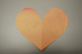
Paper heart by Sophie Armstrong
https://search.heritageburnaby.ca/link/museumdescription14749
- Repository
- Burnaby Village Museum
- Date
- March 2020
- Collection/Fonds
- Burnaby Village Museum COVID-19 collection
- Description Level
- Item
- Physical Description
- 1 drawing : wax crayon on pink construction paper ; 20 x 23.5 cm
- Scope and Content
- Item consists of a heart that has been cut out of pink coloured construction paper. One side of the heart has contains a child's drawing with markings in purple crayon while the other side is blank. The side with the markings is faded from exposure due to sunlight after being hung in a window.
- Repository
- Burnaby Village Museum
- Collection/Fonds
- Burnaby Village Museum COVID-19 collection
- Description Level
- Item
- Physical Description
- 1 drawing : wax crayon on pink construction paper ; 20 x 23.5 cm
- Scope and Content
- Item consists of a heart that has been cut out of pink coloured construction paper. One side of the heart has contains a child's drawing with markings in purple crayon while the other side is blank. The side with the markings is faded from exposure due to sunlight after being hung in a window.
- History
- This was a heart the Armstrong family made in the last week of March when things were starting to get very scary and they wanted to share their message of love and support to the world. The heart was decorated on one side by Sophie (age 1), Kimberly's youngest daughter (of two). The heart remained on the window until mid July 2020.
- Creator
- Armstrong, Sophie
- Subjects
- Arts - Drawings
- Crafts
- Pandemics - COVID-19
- Responsibility
- Paneloc Marketing Limited
- Accession Code
- BV020.24.1
- Access Restriction
- No restrictions
- Reproduction Restriction
- No known restrictions
- Date
- March 2020
- Media Type
- Graphic Material
- Notes
- Title based on contents of item
Images


![Oakalla Prison Farm, [2019] thumbnail](/media/hpo/_Data/_BVM_Images/2019/2019_0036_0001_001.jpg?width=280)
Oakalla Prison Farm
https://search.heritageburnaby.ca/link/museumdescription18849
- Repository
- Burnaby Village Museum
- Date
- [2019]
- Collection/Fonds
- Burnaby Village Museum fonds
- Description Level
- Item
- Physical Description
- 1 painting (tiff)
- Scope and Content
- Item consists of a digital copy of a painting of a view of Oakalla Prison farm with Deer Lake in the background. The original painting was created by Burnaby Village Museum preparator Carly Bowman as part of an exhibit.
- Repository
- Burnaby Village Museum
- Collection/Fonds
- Burnaby Village Museum fonds
- Series
- Museum exhibits series
- Subseries
- Museum materials for exhibits subseries
- Description Level
- Item
- Physical Description
- 1 painting (tiff)
- Scope and Content
- Item consists of a digital copy of a painting of a view of Oakalla Prison farm with Deer Lake in the background. The original painting was created by Burnaby Village Museum preparator Carly Bowman as part of an exhibit.
- Creator
- Bowman, Carly
- Names
- Oakalla Prison Farm
- Accession Code
- BV019.36.1
- Date
- [2019]
- Media Type
- Graphic Material
- Notes
- Title based on contents of item
Images
![Oakalla Prison Farm, [2019] thumbnail](/media/hpo/_Data/_BVM_Images/2019/2019_0036_0001_001.jpg)
![BFG bag prop concept plan, [2015] thumbnail](/media/hpo/_Data/_BVM_Images/2022/2022_0021_0100_001.jpg?width=280)
BFG bag prop concept plan
https://search.heritageburnaby.ca/link/museumdescription19155
- Repository
- Burnaby Village Museum
- Date
- [2015]
- Collection/Fonds
- Hipman "Jimmy" Chow and Donna Polos fonds
- Description Level
- Item
- Physical Description
- 1 photograph : col. laser print ; 28 x 43.5 cm with annotations
- Scope and Content
- Item consists of a concept plan created by concept illustrator Brian Cunningham for a leather bag to be used as a prop in the film "The BFG". Ovelay of tape with actual measurements on surface of print for the creation of the leather bag. Concept plan was used by property master, Jimmy Chow to crea…
- Repository
- Burnaby Village Museum
- Collection/Fonds
- Hipman "Jimmy" Chow and Donna Polos fonds
- Description Level
- Item
- Physical Description
- 1 photograph : col. laser print ; 28 x 43.5 cm with annotations
- Material Details
- Green masking tape and white duct tape adhered to surface of print
- Handwritten measurements in black ink written on surface of tape
- Scope and Content
- Item consists of a concept plan created by concept illustrator Brian Cunningham for a leather bag to be used as a prop in the film "The BFG". Ovelay of tape with actual measurements on surface of print for the creation of the leather bag. Concept plan was used by property master, Jimmy Chow to create the bag as a prop. The film was directed by Steven Spielberg and released in 2016.
- Creator
- Cunningham, Brian
- Subjects
- Industries - Film
- Responsibility
- Beach, Chris
- Accession Code
- BV022.21.100
- Access Restriction
- No restrictions
- Reproduction Restriction
- May be restricted by third party rights
- Date
- [2015]
- Media Type
- Graphic Material
- Notes
- Title based on contents of item
- Bottom right corner includes identifiers reading: "? / ...BFG 3 BAG_PROP CONCEPT / ... PROP BFG BAG CONCEPT / .../ Scale / 15:00:00 [sic] / ? / C_BEACH /? / B_CUNNINGHAM / ? / NONE [sic] / ? / PRP_C05 / ..."
- Drawing identifies, Brian Cunningham as concept illustrator and Chris Beach as [designer] (Art Director)
Images
![BFG bag prop concept plan, [2015] thumbnail](/media/hpo/_Data/_BVM_Images/2022/2022_0021_0100_001.jpg)

Byrne Creek Secondary School
https://search.heritageburnaby.ca/link/landmark849
- Repository
- Burnaby Heritage Planning
- Geographic Access
- 18th Street
- Associated Dates
- 2005
- Heritage Value
- Byrne Creek School opened in 2005 and accommodates students from grades 8 through 12. When built, the school was created to house as many as 1200 students, but by 2009, plans have been prepared to increase that capacity to 1500.
- Historic Neighbourhood
- Edmonds (Historic Neighbourhood)
- Planning Study Area
- Stride Avenue Area
- Street Address
- 7777 18th Street
- Street View URL
- Google Maps Street View
Images


Taylor Park Elementary School
https://search.heritageburnaby.ca/link/landmark847
- Repository
- Burnaby Heritage Planning
- Geographic Access
- Mission Avenue
- Associated Dates
- 2004
- Heritage Value
- Taylor Park Elementary School was opened in 2004 with 240 students from kindergarten to grade three (with older students attending Stride Avenue Community School). By 2006, Taylor Park had been designated as its own school and extended its classes from kindergarten through grade six.
- Historic Neighbourhood
- Edmonds (Historic Neighbourhood)
- Planning Study Area
- Stride Hill Area
- Street Address
- 7590 Mission Avenue
- Street View URL
- Google Maps Street View
Images


Property master designs for "X2: X-Men United"
https://search.heritageburnaby.ca/link/museumdescription19154
- Repository
- Burnaby Village Museum
- Date
- [2002]
- Collection/Fonds
- Hipman "Jimmy" Chow and Donna Polos fonds
- Description Level
- File
- Physical Description
- 1 portfolio : 15 photographs : col. prints + 12 col. laser prints
- Scope and Content
- File consists of a portfolio of prop concept design plans, prototypes and resource photographs for the Marvel film "X2: X-Men United". Concept designs were created by different designers and portfolio of collection was created by property master, Jimmy Chow. The portfolio was used as a communicatio…
- Repository
- Burnaby Village Museum
- Collection/Fonds
- Hipman "Jimmy" Chow and Donna Polos fonds
- Description Level
- File
- Physical Description
- 1 portfolio : 15 photographs : col. prints + 12 col. laser prints
- Scope and Content
- File consists of a portfolio of prop concept design plans, prototypes and resource photographs for the Marvel film "X2: X-Men United". Concept designs were created by different designers and portfolio of collection was created by property master, Jimmy Chow. The portfolio was used as a communication tool for sharing prototypes and plans with Jimmy's team who worked with him on the film. The film was directed by Bryan Singer and was released in 2003. Some of the concept designs within the portfolio were created by assistant art director, Brenton Harron, signed "Harron" and illustrator Dean Sherriff , signed "Sheriff".
- Accession Code
- BV022.21.107
- Access Restriction
- Restricted access
- Reproduction Restriction
- May be restricted by third party rights
- Date
- [2002]
- Media Type
- Photograph
- Graphic Material
- Scan Resolution
- 600
- Scan Date
- 2023-03-10
- Notes
- Title based on contents of file
- Title on spine of cover of portfolio reads: "X2 / PROPS"
- Chinese seal in red ink on spine of cover of portfolio identifying Jimmy Chow as the owner or creator
Images


City of Burnaby Archives
https://search.heritageburnaby.ca/link/landmark783
- Repository
- Burnaby Heritage Planning
- Geographic Access
- Albert Street
- Associated Dates
- 2001
- Heritage Value
- The City of Burnaby Archives officially opened on Saturday, November 10, 2001. The Archives is Burnaby's first municipal archives, and is located in the McGill Branch Library. The City Archives functions as a branch of the Office of the City Clerk and operates as the official repository of Burnaby's municipal records, containing records dating back to Burnaby's incorporation in 1892. In 2007, the City of Burnaby Archives expanded its collection mandate to include private as well as public records. On February 14, 2007 an agreement was signed with the Burnaby Historical Society and, as a result, the Archives accepted into its custody the collection of community records that had been maintained and managed by the Historical Society since the 1950s. In the Spring of 2007, these records were transferred from the Burnaby Village Museum to their permanent home in the Archives facility.
- Historic Neighbourhood
- Capitol Hill (Historic Neighbourhood)
- Planning Study Area
- Capitol Hill Area
- Street Address
- 4595 Albert Street
- Street View URL
- Google Maps Street View
Images


Burnaby Mountain Secondary School
https://search.heritageburnaby.ca/link/landmark831
- Repository
- Burnaby Heritage Planning
- Geographic Access
- Eastlake Drive
- Associated Dates
- 2000
- Heritage Value
- Burnaby Mountain Secondary School is one of the more recent schools in Burnaby, having opened in 2000 and it serves neighbourhoods in northeast Burnaby and northwest Coquitlam.
- Historic Neighbourhood
- Burquitlam (Historic Neighbourhood)
- Planning Study Area
- Lyndhurst Area
- Street Address
- 8800 Eastlake Drive
- Street View URL
- Google Maps Street View
Images


Shadbolt Centre for the Arts
https://search.heritageburnaby.ca/link/landmark820
- Repository
- Burnaby Heritage Planning
- Geographic Access
- Deer Lake Avenue
- Associated Dates
- 1995
- Heritage Value
- The Shadbolt Centre for the Arts opened in 1995. The Shadbolt Centre was named after two Burnaby residents who dedicated a lifetime of support and cultivation of the arts locally, nationally and internationally. Doris and Jack Shadbolt resided in Burnaby for over 50 years until Jack's death in November 1998. Doris Shadbolt spent her life's work bringing the artist and the audience closer together through her writing and curatorial work. Jack Shadbolt was an internationally recognized Canadian painter. He was also an author and both received many awards including the Order of Canada. In keeping with the Shadbolts' generosity the arts, Jack Shadbolt donated two of his paintings to the Centre for permanent display.
- Historic Neighbourhood
- Burnaby Lake (Historic Neighbourhood)
- Planning Study Area
- Douglas-Gilpin Area
- Street Address
- 6450 Deer Lake Avenue
- Street View URL
- Google Maps Street View
Images


Burnaby South Secondary School and The B.C. Provincial School for the Deaf
https://search.heritageburnaby.ca/link/landmark844
- Repository
- Burnaby Heritage Planning
- Geographic Access
- Rumble Street
- Associated Dates
- 1993
- Heritage Value
- The original Burnaby South High School was replaced in 1993 and the new Burnaby South Secondary School and BC Provincial School for the Deaf was built at this location. This school was built with the latest technology and modern equipment to ensure it was fully accessible and offers integrated academic, social and recreational activities for its students.
- Historic Neighbourhood
- Alta Vista (Historic Neighbourhood)
- Planning Study Area
- Clinton-Glenwood Area
- Street Address
- 5455 Rumble Street
- Street View URL
- Google Maps Street View
Images


South Slope Elementary School & The B.C. Provincial School for the Deaf
https://search.heritageburnaby.ca/link/landmark843
- Repository
- Burnaby Heritage Planning
- Geographic Access
- Watling Street
- Associated Dates
- 1992
- Heritage Value
- South Slope/B.C. School for the Deaf opened in 1992 and is one of the newer elementary schools in the City. The 2009 School Growth Plan notes that South Slope/BC School for the Deaf replaced the former Jericho Hill School for the Deaf in Vancouver.
- Historic Neighbourhood
- Alta Vista (Historic Neighbourhood)
- Planning Study Area
- Sussex-Nelson Area
- Street Address
- 4446 Watling Street
- Street View URL
- Google Maps Street View
Images


South Burnaby Cenotaph
https://search.heritageburnaby.ca/link/landmark860
- Repository
- Burnaby Heritage Planning
- Description
- The South Burnaby Cenotaph is located in Bonsor Park at the corner of Nelson Avenue and Imperial Street. The cenotaph commemorates those lost in the First World War, Second World War and the Korean War.
- Associated Dates
- 1988
- Other Names
- Bonsor Park Cenotaph
- Street View URL
- Google Maps Street View
- Repository
- Burnaby Heritage Planning
- Other Names
- Bonsor Park Cenotaph
- Geographic Access
- Nelson Avenue
- Associated Dates
- 1988
- Description
- The South Burnaby Cenotaph is located in Bonsor Park at the corner of Nelson Avenue and Imperial Street. The cenotaph commemorates those lost in the First World War, Second World War and the Korean War.
- Historic Neighbourhood
- Central Park (Historic Neighbourhood)
- Planning Study Area
- Marlborough Area
- Community
- Burnaby
- Cadastral Identifier
- P.I.D. No. 027-719-375
- Boundaries
- The property (Bonsor Park) is comprised of a single municipally-owned property located at 6749 Nelson Avenue.
- Area
- 3570.00
- Contributing Resource
- Landscape Feature
- Structure
- Ownership
- Public (local)
- Street Address
- 6749 Nelson Avenue
- Street View URL
- Google Maps Street View
Images


Forest Grove School
https://search.heritageburnaby.ca/link/landmark795
- Repository
- Burnaby Heritage Planning
- Geographic Access
- Forest Grove Drive
- Associated Dates
- 1986
- Heritage Value
- The Forest Grove subdivision in Burnaby was developed during the early 1980s and resulted in a rapidly growing population that required a school facility to support this "instant" community. Forest Grove Elementary was the second largest elementary school in the city when it opened and 374 pupils were recorded in its first year.
- Planning Study Area
- Lake City Area
- Street Address
- 8525 Forest Grove Drive
- Street View URL
- Google Maps Street View
Images


Metrotown
https://search.heritageburnaby.ca/link/landmark817
- Repository
- Burnaby Heritage Planning
- Geographic Access
- Kingsway
- Associated Dates
- 1986
- Heritage Value
- Although the idea for Metrotown was first expressed in the 1970s, the building itself opened in 1986 and was soon served by the Expo Line of the new SkyTrain system. In the ensuing twenty years, the complex developed into three distinct but adjoining malls - Metropolis at Metrotown, Metrotown Centre, and Station Square. Today, Metrotown serves as the city’s commercial and retail anchor. The mall also includes two large office towers, which by 2001 were home to the head offices for Shaw Cable and TransLink.
- Historic Neighbourhood
- Central Park (Historic Neighbourhood)
- Planning Study Area
- Maywood Area
- Street Address
- 4700 Kingsway
- Street View URL
- Google Maps Street View
Images

![Burnaby Village Museum - Entrance, [1985] thumbnail](/media/hpo/_Data/_BVM_Architectural_Drawings/2019_0052_0088_001.jpg?width=280)
Burnaby Village Museum - Entrance
https://search.heritageburnaby.ca/link/museumdescription11752
- Repository
- Burnaby Village Museum
- Date
- [1985]
- Collection/Fonds
- Century Park Museum Association fonds
- Description Level
- Item
- Physical Description
- 1 drawing : b&w print hand col. (pencil crayons) on paper 46 x 58 cm ; mounted on foamcore board 71 x 58 cm
- Scope and Content
- Item consists of a presentation drawing for the proposed Burnaby Village Museum Expansion. Title at bottom of drawing "Entrance to the walkway / from the west".
- Repository
- Burnaby Village Museum
- Collection/Fonds
- Century Park Museum Association fonds
- Description Level
- Item
- Physical Description
- 1 drawing : b&w print hand col. (pencil crayons) on paper 46 x 58 cm ; mounted on foamcore board 71 x 58 cm
- Scope and Content
- Item consists of a presentation drawing for the proposed Burnaby Village Museum Expansion. Title at bottom of drawing "Entrance to the walkway / from the west".
- Names
- Burnaby Village Museum
- Accession Code
- BV019.52.88
- Access Restriction
- No restrictions
- Reproduction Restriction
- May be restricted by third party rights
- Date
- [1985]
- Media Type
- Graphic Material
- Notes
- Title based on contents of drawing
Images
![Burnaby Village Museum - Entrance, [1985] thumbnail](/media/hpo/_Data/_BVM_Architectural_Drawings/2019_0052_0088_001.jpg)
![Burnaby Village Museum - Inside the museum, [1985] thumbnail](/media/hpo/_Data/_BVM_Architectural_Drawings/2019_0052_0089_001.jpg?width=280)
Burnaby Village Museum - Inside the museum
https://search.heritageburnaby.ca/link/museumdescription11753
- Repository
- Burnaby Village Museum
- Date
- [1985]
- Collection/Fonds
- Century Park Museum Association fonds
- Description Level
- Item
- Physical Description
- 1 drawing : b&w print hand col. (pencil crayons) on paper 46 x 58 cm ; mounted on foamcore board 71 x 58 cm
- Scope and Content
- Item consists of a presentation drawing for the proposed Burnaby Village Museum Expansion. Title at bottom of drawing "Inside the museum".
- Repository
- Burnaby Village Museum
- Collection/Fonds
- Century Park Museum Association fonds
- Description Level
- Item
- Physical Description
- 1 drawing : b&w print hand col. (pencil crayons) on paper 46 x 58 cm ; mounted on foamcore board 71 x 58 cm
- Scope and Content
- Item consists of a presentation drawing for the proposed Burnaby Village Museum Expansion. Title at bottom of drawing "Inside the museum".
- Subjects
- Buildings - Civic - Museums
- Names
- Burnaby Village Museum
- Accession Code
- BV019.52.89
- Access Restriction
- No restrictions
- Reproduction Restriction
- May be restricted by third party rights
- Date
- [1985]
- Media Type
- Graphic Material
- Notes
- Title based on contents of drawing
Images
![Burnaby Village Museum - Inside the museum, [1985] thumbnail](/media/hpo/_Data/_BVM_Architectural_Drawings/2019_0052_0089_001.jpg)
![Burnaby Village Museum - Looking east towards the Adminstration complex, [1985] thumbnail](/media/hpo/_Data/_BVM_Architectural_Drawings/2019_0052_0090_001.jpg?width=280)
Burnaby Village Museum - Looking east towards the Adminstration complex
https://search.heritageburnaby.ca/link/museumdescription11754
- Repository
- Burnaby Village Museum
- Date
- [1985]
- Collection/Fonds
- Century Park Museum Association fonds
- Description Level
- Item
- Physical Description
- 1 drawing : b&w print hand col. (pencil crayons) on paper 46 x 58 cm ; mounted on foamcore board 71 x 58 cm
- Scope and Content
- Item consists of a presentation drawing for the proposed Burnaby Village Museum Expansion. Title at bottom of drawing "Looking east towards / the Adminstration / complex"
- Repository
- Burnaby Village Museum
- Collection/Fonds
- Century Park Museum Association fonds
- Description Level
- Item
- Physical Description
- 1 drawing : b&w print hand col. (pencil crayons) on paper 46 x 58 cm ; mounted on foamcore board 71 x 58 cm
- Scope and Content
- Item consists of a presentation drawing for the proposed Burnaby Village Museum Expansion. Title at bottom of drawing "Looking east towards / the Adminstration / complex"
- Subjects
- Buildings - Civic - Museums
- Names
- Burnaby Village Museum
- Accession Code
- BV019.52.90
- Access Restriction
- No restrictions
- Reproduction Restriction
- May be restricted by third party rights
- Date
- [1985]
- Media Type
- Graphic Material
- Notes
- Title based on contents of drawing
Images
![Burnaby Village Museum - Looking east towards the Adminstration complex, [1985] thumbnail](/media/hpo/_Data/_BVM_Architectural_Drawings/2019_0052_0090_001.jpg)

Stoney Creek Elementary School
https://search.heritageburnaby.ca/link/landmark836
- Repository
- Burnaby Heritage Planning
- Geographic Access
- Beaverbrook Crescent
- Associated Dates
- 1974
- Heritage Value
- Overcrowding at both Lyndhurst and Cameron Road schools in the early 1970s prompted the construction of the Stoney Creek Community School in 1974. Opening with 101 students, the school was expanded with the addition of six classrooms, a library and activity room in 1976.
- Historic Neighbourhood
- Burquitlam (Historic Neighbourhood)
- Planning Study Area
- Lyndhurst Area
- Street Address
- 2740 Beaverbrook Crescent
- Street View URL
- Google Maps Street View
Images


Kensington Arena
https://search.heritageburnaby.ca/link/landmark787
- Repository
- Burnaby Heritage Planning
- Geographic Access
- Curtis Street
- Associated Dates
- 1973
- Heritage Value
- In 1972, the Burnaby Parks Commission considered numerous requests from the community to increase the available ice rink surfaces in the city and voted to build a new full-sized rink instead of adding to the existing municipal rink facility. The new arena was to be situated in North Burnaby and was opened in 1973 adjacent to Kensington Park.
- Planning Study Area
- Parkcrest-Aubrey Area
- Street Address
- 6159 Curtis Street
- Street View URL
- Google Maps Street View
Images


Montecito Elementary School
https://search.heritageburnaby.ca/link/landmark796
- Repository
- Burnaby Heritage Planning
- Geographic Access
- Duthie Avenue
- Associated Dates
- 1972
- Heritage Value
- The neighbourhood between Sperling Avenue and Burnaby Golf course was beginning to see a rapid development during the late 1960s causing the School Board to determine the need for a school to be built there. This was one of the last schools to be built in Burnaby before school enrolments in general began declining in the late 1970s.
- Planning Study Area
- Sperling-Broadway Area
- Street Address
- 2176 Duthie Avenue
- Street View URL
- Google Maps Street View
Images
