Narrow Results By
Decade
- 2020s
- 2010s 233
- 2000s 310
- 1990s 1027
- 1980s 844
- 1970s 2042
- 1960s 738
- 1950s 895
- 1940s 1204
- 1930s 1350
- 1920s 1594
- 1910s 1568
- 1900s 969
- 1890s 349
- 1880s 141
- 1870s
- 1860s
- 1850s 26
- 1840s 17
- 1830s 8
- 1820s 5
- 1810s 5
- 1800s 8
- 1790s 4
- 1780s 3
- 1770s 3
- 1760s 3
- 1750s 3
- 1740s 3
- 1730s 3
- 1720s 3
- 1710s 5
- 1700s 4
- 1690s 3
- 1680s 4
- 1670s 3
- 1660s 3
- 1650s 3
- 1640s 3
- 1630s 3
- 1620s 3
- 1610s 3
- 1600s 3
- 1520s 1
Creator
- Albert, Charles d' 1809-1886 1
- Alger, Horatio, Jr., 1832-1899 2
- American Bible Society 1
- Armstrong, Sophie 1
- Ashe, T. (Thomas), 1836-1889 1
- Ballantyne, R. M. (Robert Michael), 1825-1894 1
- Bateman, Caroline Mary Wettenhall 1
- Binks, James 8
- Blackmore, R. D., (Richard Doddridge), 1825-1900 1
- Brenda 1
- Burnaby, Fred, 1842-1885 1
- Burnaby Village Museum 57
![Sir John A. MacDonald, [186-] thumbnail](/media/hpo/_Data/_BVM_Images/1990/199800440001.jpg?width=280)
Sir John A. MacDonald
https://search.heritageburnaby.ca/link/museumdescription1304
- Repository
- Burnaby Village Museum
- Date
- [186-]
- Collection/Fonds
- Burnaby Village Museum Photograph collection
- Description Level
- Item
- Physical Description
- 1 photograph : sepia ; 14 x 10 cm mounted on heavy card 16.5 x 10.5 cm
- Scope and Content
- Photograph portrait of Canada's first prime minister, Sir John A. MacDonald taken in a photographic studio.
- Repository
- Burnaby Village Museum
- Collection/Fonds
- Burnaby Village Museum Photograph collection
- Description Level
- Item
- Physical Description
- 1 photograph : sepia ; 14 x 10 cm mounted on heavy card 16.5 x 10.5 cm
- Scope and Content
- Photograph portrait of Canada's first prime minister, Sir John A. MacDonald taken in a photographic studio.
- Subjects
- Officials - Prime Ministers
- Names
- MacDonald, John A.
- Accession Code
- BV998.44.1
- Access Restriction
- No restrictions
- Reproduction Restriction
- No known restrictions
- Date
- [186-]
- Media Type
- Photograph
- Scan Resolution
- 600
- Scan Date
- 02-Jun-09
- Scale
- 100
- Notes
- Title based on contents of photograph
- 1 b&w photocopy accompanying
Images
![Sir John A. MacDonald, [186-] thumbnail](/media/hpo/_Data/_BVM_Images/1990/199800440001.jpg)
![Man in a tweed coat, [between 1870 and 1889] thumbnail](/media/hpo/_Data/_BVM_Images/1985/198557630001.jpg?width=280)
Man in a tweed coat
https://search.heritageburnaby.ca/link/museumdescription1390
- Repository
- Burnaby Village Museum
- Date
- [between 1870 and 1889]
- Collection/Fonds
- Burnaby Village Museum Photograph collection
- Description Level
- Item
- Physical Description
- 1 photograph : b&w hand-tinted into col.
- Scope and Content
- Photograph of an unidentified man dressed in a tweed coat and collarless jacket taken in a photographic studio. He has a full beard. The cheeks and the lips are hand tinted pink.
- Repository
- Burnaby Village Museum
- Collection/Fonds
- Burnaby Village Museum Photograph collection
- Description Level
- Item
- Physical Description
- 1 photograph : b&w hand-tinted into col.
- Scope and Content
- Photograph of an unidentified man dressed in a tweed coat and collarless jacket taken in a photographic studio. He has a full beard. The cheeks and the lips are hand tinted pink.
- Accession Code
- BV985.5763.1
- Access Restriction
- No restrictions
- Reproduction Restriction
- No known restrictions
- Date
- [between 1870 and 1889]
- Media Type
- Photograph
- Scan Resolution
- 600
- Scan Date
- 2024-02-02
- Notes
- Title based on contents of photograph
Images
![Man in a tweed coat, [between 1870 and 1889] thumbnail](/media/hpo/_Data/_BVM_Images/1985/198557630001.jpg)
![Seated woman, [187-] thumbnail](/media/hpo/_Data/_BVM_Images/1985/1985_5809_0001_001.jpg?width=280)
Seated woman
https://search.heritageburnaby.ca/link/museumdescription1434
- Repository
- Burnaby Village Museum
- Date
- [187-]
- Collection/Fonds
- Burnaby Village Museum Photograph collection
- Description Level
- Item
- Physical Description
- 1 photograph : b&w tintype hand-tinted into col. ; 8 x 5 cm
- Scope and Content
- Photographic tintype of an unidentified young woman sitting on a chair. Her left arm is resting on a table with a cover on it. Her cheeks are hand tinted pink.
- Repository
- Burnaby Village Museum
- Collection/Fonds
- Burnaby Village Museum Photograph collection
- Description Level
- Item
- Physical Description
- 1 photograph : b&w tintype hand-tinted into col. ; 8 x 5 cm
- Scope and Content
- Photographic tintype of an unidentified young woman sitting on a chair. Her left arm is resting on a table with a cover on it. Her cheeks are hand tinted pink.
- Accession Code
- BV985.5809.1
- Access Restriction
- No restrictions
- Reproduction Restriction
- No known restrictions
- Date
- [187-]
- Media Type
- Photograph
- Scan Resolution
- 600
- Scan Date
- 2024-02-27
- Notes
- Title based on contents of photograph
Images
![Seated woman, [187-] thumbnail](/media/hpo/_Data/_BVM_Images/1985/1985_5809_0001_001.jpg)
![Unidentified couple, [186-] thumbnail](/media/hpo/_Data/_BVM_Images/2000/200500590016.jpg?width=280)
Unidentified couple
https://search.heritageburnaby.ca/link/museumdescription1949
- Repository
- Burnaby Village Museum
- Date
- [186-]
- Collection/Fonds
- Burnaby Village Museum Photograph collection
- Description Level
- Item
- Physical Description
- 1 photograph : b&w tintype ; 8 x 6 cm
- Scope and Content
- Photograph of an unidentified couple taken in a photographic studio. The man is standing, wearing a three piece suit (his blazer has been left unbuttoned), with his hat held in his right hand. The woman is seated beside him, in a simple dress with a lace collar.
- Repository
- Burnaby Village Museum
- Collection/Fonds
- Burnaby Village Museum Photograph collection
- Description Level
- Item
- Physical Description
- 1 photograph : b&w tintype ; 8 x 6 cm
- Scope and Content
- Photograph of an unidentified couple taken in a photographic studio. The man is standing, wearing a three piece suit (his blazer has been left unbuttoned), with his hat held in his right hand. The woman is seated beside him, in a simple dress with a lace collar.
- Accession Code
- BV005.59.16
- Access Restriction
- No restrictions
- Reproduction Restriction
- No known restrictions
- Date
- [186-]
- Media Type
- Photograph
- Scan Resolution
- 600
- Scan Date
- 11-Jun-09
- Scale
- 100
- Notes
- Title based on contents of photograph
Images
![Unidentified couple, [186-] thumbnail](/media/hpo/_Data/_BVM_Images/2000/200500590016.jpg)
![Elmire Beaudoin, [1873 or 1874] thumbnail](/media/hpo/_Data/_BVM_Images/1971/1971_0124_0014_001.jpg?width=280)
Elmire Beaudoin
https://search.heritageburnaby.ca/link/museumdescription2970
- Repository
- Burnaby Village Museum
- Date
- [1873 or 1874]
- Collection/Fonds
- Burnaby Village Museum Photograph collection
- Description Level
- Item
- Physical Description
- 1 photograph : b&w tintype hand-tinted into col. ; 8.8 x 5.5 cm
- Scope and Content
- Photographic tintype of a small girl named Elmire Beaudoin sitting on a table draped with patterned material. She is wearing a dress with a hairband and a necklace. An envelope in which the tintype was enclosed is annotated, ""Elmire Beaudoin/ b. 1868 - Montreal P.Q."
- Repository
- Burnaby Village Museum
- Collection/Fonds
- Burnaby Village Museum Photograph collection
- Description Level
- Item
- Physical Description
- 1 photograph : b&w tintype hand-tinted into col. ; 8.8 x 5.5 cm
- Scope and Content
- Photographic tintype of a small girl named Elmire Beaudoin sitting on a table draped with patterned material. She is wearing a dress with a hairband and a necklace. An envelope in which the tintype was enclosed is annotated, ""Elmire Beaudoin/ b. 1868 - Montreal P.Q."
- History
- 1871 census records show that Elmire Beaudoin was born in 1868 to Ephrem and Philomene Beaudoin in the region of St. Henri Quebec. The family had many children: Marie, Elmire and Arthur, Rosanna, Emma, Amedea, Alphonsine, Josephe and Eladora, Marie Louise. Ephrem worked as a "cultivator". By the 1891 census, Elmire has married and presumably taken her husband's name.
- Names
- Beaudoin, Elmire
- Accession Code
- HV971.124.14
- Access Restriction
- No restrictions
- Reproduction Restriction
- No known restrictions
- Date
- [1873 or 1874]
- Media Type
- Photograph
- Scan Resolution
- 600
- Scan Date
- 2023-03-28
- Notes
- Title based on contents of photograph
Images
![Elmire Beaudoin, [1873 or 1874] thumbnail](/media/hpo/_Data/_BVM_Images/1971/1971_0124_0014_001.jpg)
![Photograph and case, [between 1854 and 1870] thumbnail](/media/hpo/_Data/_BVM_Images/2000/200000080011.jpg?width=280)
Photograph and case
https://search.heritageburnaby.ca/link/museumdescription3219
- Repository
- Burnaby Village Museum
- Date
- [between 1854 and 1870]
- Collection/Fonds
- Burnaby Village Museum Photograph collection
- Description Level
- Item
- Physical Description
- 1 photograph : ambrotype ; 8.5 x 9.5 cm in leather case
- Repository
- Burnaby Village Museum
- Collection/Fonds
- Burnaby Village Museum Photograph collection
- Description Level
- Item
- Physical Description
- 1 photograph : ambrotype ; 8.5 x 9.5 cm in leather case
- Material Details
- Photograph case with convex glass front with ambrotype photograph of man in dress suit, from waist up. The subject's cheeks have been toned pink.The interior back of the case is lined with cream paper and printed with "MYRON SHEW, Dealer in Daguerreotype Materials No. 116 Chestnut Street, PHILADELPHIA". Gold matting; "CHASE" stamped into matting, lower right; exterior of frame is covered in leather; interior is red-coloured velvet; both surfaces embossed with floral motif.
- Accession Code
- BV000.8.11
- Access Restriction
- No restrictions
- Date
- [between 1854 and 1870]
- Media Type
- Photograph
Images
![Photograph and case, [between 1854 and 1870] thumbnail](/media/hpo/_Data/_BVM_Images/2000/200000080011.jpg)
![Portrait of William Holmes, [between 1841 and 1860] thumbnail](/media/hpo/_Data/_BVM_Images/1971/197100460001.jpg?width=280)
Portrait of William Holmes
https://search.heritageburnaby.ca/link/museumdescription3961
- Repository
- Burnaby Village Museum
- Date
- [between 1841 and 1860]
- Collection/Fonds
- William Holmes fonds
- Description Level
- Item
- Physical Description
- 1 photograph (calotype) : b&w ; 50 x 39.5 cm (oval, sight) in frame 66 x 56 cm
- Scope and Content
- Photograph portrait of William Holmes.
- Repository
- Burnaby Village Museum
- Collection/Fonds
- William Holmes fonds
- Description Level
- Item
- Physical Description
- 1 photograph (calotype) : b&w ; 50 x 39.5 cm (oval, sight) in frame 66 x 56 cm
- Material Details
- The photograph is a calotype print, which has been enhanced using charcoal and paint.
- Scope and Content
- Photograph portrait of William Holmes.
- History
- William Holmes was the first non-Indigenous resident of Burnaby.
- Names
- Holmes, William
- Accession Code
- HV971.46.1
- Access Restriction
- No restrictions
- Reproduction Restriction
- May be restricted by third party rights
- Date
- [between 1841 and 1860]
- Media Type
- Photograph
- Related Material
- Portrait of Jane Holmes, HV971.46.2
- Notes
- Title based on contents of photograph
Images
![Portrait of William Holmes, [between 1841 and 1860] thumbnail](/media/hpo/_Data/_BVM_Images/1971/197100460001.jpg)
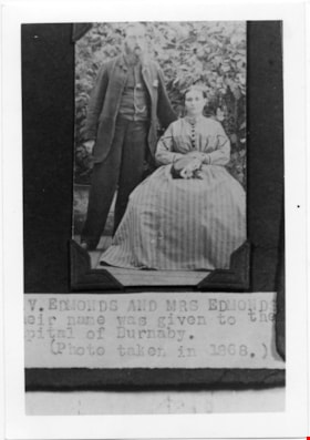
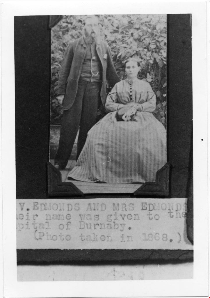
Mr and Mrs V Edmonds
https://search.heritageburnaby.ca/link/museumdescription4779
- Repository
- Burnaby Village Museum
- Date
- 1868
- Collection/Fonds
- Burnaby Village Museum Photograph collection
- Description Level
- Item
- Physical Description
- 1 photograph : b&w ; 12.6 x 8.8 cm ; copy print
- Scope and Content
- Portrait of married couple, he standing, she sitting, in front of some shrubbery.
- Repository
- Burnaby Village Museum
- Collection/Fonds
- Burnaby Village Museum Photograph collection
- Description Level
- Item
- Physical Description
- 1 photograph : b&w ; 12.6 x 8.8 cm ; copy print
- Material Details
- "Columbian files 1971" written on verso in black pen. "V. EDMONDS AND MRS EDMONDS / […]eir name was given to the / Capital of Burnaby. / (Photo taken in 1868.)" on typewritten label on front of photograph.
- Scope and Content
- Portrait of married couple, he standing, she sitting, in front of some shrubbery.
- History
- Part of a set of photographs from the Columbian Newspaper, which operated out of New Westminster under this name starting in 1900 until its dissolution in 1988. Photographs found in the collection of the Burnaby Village are dated 1971.
- Other Title Information
- title based on note on front of photograph
- Accession Code
- BV018.19.5
- Access Restriction
- No restrictions
- Reproduction Restriction
- May be restricted by third party rights
- Date
- 1868
- Media Type
- Photograph
- Scan Resolution
- 600
- Scan Date
- 24-04-2018
Images
![Survey and Subdivision plans in New Westminster District Group 1 – Burnaby
, [1861]-[1910] thumbnail](/media/hpo/_Data/_BVM_Cartographic_Material/1977/1977_0093_0019a_001.jpg?width=280)
Survey and Subdivision plans in New Westminster District Group 1 – Burnaby
https://search.heritageburnaby.ca/link/museumdescription6988
- Repository
- Burnaby Village Museum
- Date
- [1861]-[1910]
- Collection/Fonds
- Burnaby Village Museum Map collection
- Description Level
- File
- Physical Description
- 14 plans : 3 plans : black ink on paper hand col. + 7 plans : black ink on paper + 4 plans : graphite on paper mounted on 2 sides of cardboard 76 x 102 cm
- Scope and Content
- Item consists of a large board of four New Westminster District Gp 1 - subdivision plans mounted on one side and ten New Westminster District Gp 1 - subdivision plans mounted on the other side. Side A: 1. "Plan /of / Lots 166A, 166 and 167 /, Gr.1, N.W.D. / Showing Misconstructed Roads in Gree…
- Repository
- Burnaby Village Museum
- Collection/Fonds
- Burnaby Village Museum Map collection
- Description Level
- File
- Physical Description
- 14 plans : 3 plans : black ink on paper hand col. + 7 plans : black ink on paper + 4 plans : graphite on paper mounted on 2 sides of cardboard 76 x 102 cm
- Material Details
- Scales [between 1:2376 and 1:7920]
- Index number on edge of board reads: "19"
- Scope and Content
- Item consists of a large board of four New Westminster District Gp 1 - subdivision plans mounted on one side and ten New Westminster District Gp 1 - subdivision plans mounted on the other side. Side A: 1. "Plan /of / Lots 166A, 166 and 167 /, Gr.1, N.W.D. / Showing Misconstructed Roads in Green / 5 chs = 1 in.". (plan is drawn in black ink and hand coloured in red, green and orange ink). A section in the centre of the plan is coloured in red ink and identified as "C.S. Richmond" running from the North Arm of Fraser River to Wiggins Road and divided by "New Wiggins Rd. (as gazetted)" (coloured in orange ink) and two"Constructed Road(s)" (coloured in green ink). Plan is initialed by: "RB" [sic] (in blue pencil crayon) 2. Plan of / Subdivision of / Lot 166 / Group One / New Westminster District / Scale 4 chs = 1 in. / Map No 524". Plan is drawn in graphite and signed by "Surrig [sic] Welhams [sic] / P.L.S." Plan is initialed by: "RB" [sic] (in blue pencil crayon) 3. Plan of "Survey / of Highway / For / Burnaby Council / in / Lots 13 _14 / Group One / Scale 4 chs = 1 in." Signed by "Albert J. Hill, P.L.S." Caribou Street and Caribou Road run through the centre of the plan. Plan is stamped: "Albert J. Hill, Civil Engineer / and / Provincial Land Surveyor, / New Westminster, / B.C.". Plan is initialed by: "RB" [sic] (in blue pencil crayon) 4. A Plan of Lots 166A, 166 and 167, Group One, New Westminster District (drawn in graphite). A section in the centre of the plan is identified as "C.S. Richmond" running from the North Arm of Fraser River and divided by "New Wiggins Rd. (as gazetted)" and two "Constructed Road(s)". Plan is initialed by: "RB" [sic] (in blue pencil crayon) Side B: 1. Small plan drawn in black ink (no title) identifying lots north of the "North Arm" of the Fraser River. Lots identified include: Lot 99, Lot 98, Lot 157, Lot 158, Lot 163, Lot 162, Lot 159, Lot 163, Lot 162, Lot 165, Lot 166A, Lot 155B, Lot 155A and Lot 159. "Scale 40 chains to one inch" . Plan is initialed by: "RB" [sic] (in blue pencil crayon) (Geographic location: Burnaby) 2. Small plan drawn in black ink (no title) identifying lots north of the North Arm of the Fraser River as "Lots 155, 155A, 155B, 155C, 162, 163, 164, 165, 166A and 167". Plan is initialed by: "RB" [sic] (in blue pencil crayon) (Geographic location: Burnaby) 3. Small plan drawn in black ink (no title) which identifies "Lot 151 / Reserve/ for / Race Course"; "Reserve / 64 A / L. 152 G.1"; and other Lots: 32, 33, 34, 35, 36, 38, 39. The plan is signed "Surveyor G.Turn [sic] July / 61 / from Vol 40 R.L. notes [sic]" Plan is stamped: "Albert J. Hill, Civil Engineer / and / Provincial Land Surveyor, / New Westminster, / B.C." Plan is initialed by: "RB" [sic] (in blue pencil crayon) (Geographic location: Burnaby) 4. Small plan drawn in black in with faded red colouring on centre lot identified as "Lot 34" running north from "Vancouver Road" . Plan is stamped: "Albert J. Hill, Civil Engineer / and / Provincial Land Surveyor, / New Westminster, / B.C." Plan is initialed by: "RB" [sic] (in blue pencil crayon) (Geographic location: Burnaby) 5. Plan drawn in graphite and identified as "Lot 98, Gr.1," along with the intials "RB" [sic] (both are handwritten in blue crayon pencil on top of plan) The B.C.E.Railway is identified running through the plan along with Jubilee Road and Royal Oak Road. The plan is signed with the name "Wm. Murray" and the Plan is stamped: "Albert J. Hill, Civil Engineer / and / Provincial Land Surveyor, / New Westminster, / B.C.". (Geographic location: Burnaby) 6. Plan drawn in graphite identified as "Port Lot 13, Gr.1" along with the intials "RB" [sic] (both are handwritten in blue crayon pencil on top of plan) Plan is stamped: "Albert J. Hill, Civil Engineer / and / Provincial Land Surveyor, / New Westminster, / B.C.". (Geographic location: Burnaby) 7.Plan drawn in black ink and identified as "Lot 98 G.1" along with the intials "RB" [sic] (both are handwritten in blue crayon pencil on top of plan). A "Road Reservation" is identified running north between "Electric Tramway" and connecting with "Royal Oak Road". Plan is stamped: "Albert J. Hill, Civil Engineer / and / Provincial Land Surveyor, / New Westminster, / B.C." (Geographic location: Burnaby) 8. Plan drawn in black ink and divided into two sections, the upper plan is identified as "Portion / Lots 100 / area / 101, Gr.1" and the lower plan is identified as "Portion L. 3 G. 1" along with the intials "RB" [sic] (these identifiers are handwritten in blue crayon pencil on top of the plan). Portions of Lot 100 and Lot 101 are each divided into 6 sections and the Portion of Lot 3 plan is divided into 24 sections. The plan includes a note in black ink that reads: " Received from Wm Fromme [sic] / from Wm. Trapp / Nov. 28, 1895 / A. J. T...[sic]". (Geographic location: Burnaby) 9. Plan drawn in black ink (no title) identifying soil, buildings and geographic features in southern Burnaby. The plan is bordered by "New Westminster City" (Tenth Avenue and DL 172) to the south east and DL 173 to the south, DL 158 to the west and the B.C.E. Tramway to the north. Plan includes District Lots: 155A, 158, 159, 171, 160, 53 and 95 and identifies soil, marshland and ravines throughout. Plan identifies the following features: a "Team Road" running through Lots 158 and 159 along with "Fair Orchard Soil / Even Surface Throughout / No Ravines", "Gravel and Shingle" (bottom of Lot 158), "North Arm Road" crossing "Byrne Road" and connecting with "Power House Road" which runs north to connect with "Highland Park Station" and the B.C.E. Tramway, "Power Ho" in the northeast corner of DL 160, a "Brook" connected with a "Deep Ravine" running between DL 53, DL 95 and DL 160 along with "Good Soil" and "Fair Orchard Soil" identified nearby in DL 95. Scale is identified as "10 chs = 1 in." Plan is stamped: "Albert J. Hill, Civil Engineer / and / Provincial Land Surveyor, / New Westminster, / B.C." Plan is initialed by: "RB" [sic] (in blue pencil crayon) (Geographic location: Burnaby) 10. Plan drawn in black ink (no title) with Burnaby Lake and Deer Lake at the centre. The plan is bordered by the following District Lots identified as: 117, 118 and 68 to the west, Lots 80, 79 and 85 to the southwest, Lots 11, 13, and 1 (City of New Westminster) to the south east, the North Road boundary to the east and Lots 8, 56, 57, 59, and 136 to the North. The lower right hand corner of the plan has a small inset which reads: "Burnaby Lake" and "Page 19 R.B. Notes". Plan is initialed by: "RB" [sic] (in blue pencil crayon) (Geographic location: Burnaby)
- Creator
- Hill, Albert James
- Accession Code
- HV977.93.19
- Access Restriction
- No restrictions
- Reproduction Restriction
- No known restrictions
- Date
- [1861]-[1910]
- Media Type
- Cartographic Material
- Scan Resolution
- 300
- Scale
- 72
- Notes
- Title based on contents of file
- Scale is measured in chains. (One chain equals 792 inches)
- The term "Lot" can also refer to a "District Lot”
- Some plans are stamped: "Albert J. Hill, Civil Engineer / and / Provincial Land Surveyor, / New Westminster, / B.C." and intialed: "RB" [sic]
Images
![Survey and Subdivision plans in New Westminster District Group 1 – Burnaby
, [1861]-[1910] thumbnail](/media/hpo/_Data/_BVM_Cartographic_Material/1977/1977_0093_0019a_001.jpg)

![Survey and Subdivision plans in New Westminster District Group 1 – Burnaby, Port Moody, [1862-1908] thumbnail](/media/hpo/_Data/_BVM_Cartographic_Material/1977/1977_0093_0026a_001.jpg?width=280)
Survey and Subdivision plans in New Westminster District Group 1 – Burnaby, Port Moody
https://search.heritageburnaby.ca/link/museumdescription6995
- Repository
- Burnaby Village Museum
- Date
- [1862-1908]
- Collection/Fonds
- Burnaby Village Museum Map collection
- Description Level
- File
- Physical Description
- 9 plans : 6 plans : black ink on paper ; 57 x 36.5 cm or smaller + 1 plan : black ink and grahite on paper ; 46.5 x 49 cm + 1 plan : blueprint on paper ; 15.5 x 19.5 cm + cm + 1 plan : graphite on paper ; 25 x 17 cm ; mounted on both sides of board 76 x 102 cm
- Scope and Content
- Item consists of a large board of four New Westminster District subdivision plans mounted on one side and five New Westminster District subdivision plans mounted on the other side. Side A: 1. "Plan / of Subdivision / of a Portion / of / Lot 87 / Group One / New Westminster District / Scale 4 chs…
- Repository
- Burnaby Village Museum
- Collection/Fonds
- Burnaby Village Museum Map collection
- Description Level
- File
- Physical Description
- 9 plans : 6 plans : black ink on paper ; 57 x 36.5 cm or smaller + 1 plan : black ink and grahite on paper ; 46.5 x 49 cm + 1 plan : blueprint on paper ; 15.5 x 19.5 cm + cm + 1 plan : graphite on paper ; 25 x 17 cm ; mounted on both sides of board 76 x 102 cm
- Material Details
- Scales [between 1:792 and 1:3600]
- Index number on edge of board reads: "26"
- Scope and Content
- Item consists of a large board of four New Westminster District subdivision plans mounted on one side and five New Westminster District subdivision plans mounted on the other side. Side A: 1. "Plan / of Subdivision / of a Portion / of / Lot 87 / Group One / New Westminster District / Scale 4 chs = 1 in". Plan is stamped: "Albert J. Hill, Civil Engineer / and / Provincial Land Surveyor, / New Westminster, / B.C." and intialed by: "RB" [sic] (in blue pencil crayon). Names two of the subdivisons of District Lot 87 are identified as, "L.E. Sprott" and "John Ledger". (Geographic location: Burnaby) 2. "Plan of Subdivision / of / Portions of / Lot 136, 131 and Lots 44 and 78 Gr.1 / New Westminster District / Scale 300 ft = 1 inch". Annotation above title reads: "No. 901 / Deposited in Land Registry Office / New Westminster / Aug. 19th 1905 / Charles S. Keith D. Reg." Annotations and signatures at bottom of plan read: "I, William Nelson Draper, / W.H.R. Collister / Charles E. Perkins / E.B. Morgan / make / Surveys / correct / representation / upon / the / Land Registry Act / (sgd) W.N. Draper, P.L.S.". Plan includes a handwritten title: "Lots 136, 131, 44 & 78" and is initialed: "RB" [sic] (in blue pencil crayon) (Geographic location: Burnaby) 3. "Survey / of / a Portion / of / Lot 95, Gr.1 / Scale 1 ch = 1in." Plan is stamped: "Albert J. Hill, Civil Engineer / and / Provincial Land Surveyor, / New Westminster, / B.C." and is initialed : "RB" [sic] (in blue pencil crayon) (Geographic location: Burnaby) 4. Blueprint plan of "Lot 396. Group One." with Scale : 3 chs = 1 in. A two acre portion of District Lot 396 is filled in with red ink." Plan is signed by "Albert J. Hill / B.C.L.S." (Geographic location: Port Moody) Side B: 1. Plan titled "District Lot 92 / Burnaby / Municipality / for sale by / Mahon / McFarland & / Mahon Ltd. / Vancouver, B.C. / Scale : 4 chains to one inch". District Lot 92 is subdivided into 161 lots and identifies roads: Norwich Road, Pole Line Road, Oakland Road, Stanley Road, Burford Road, Dalhousie Road, Brantford Road, Colborne Road, Roberts Road, Vancouver & Westminster Road, B.C. Electric Railway, Gilley Stn. and Burnaby (Power House). The bottom of the plan reads: "G.S. Dawson, P.LS. Vancouver, B.C." (Geographic location: Burnaby) 2. "Plan / of Subdivision / of a Portion / of / Lot 29 / Group 1 / New Westminster District / Scale 2 chs = 1 in". Plan is stamped: "Albert J. Hill, Civil Engineer / and / Provincial Land Surveyor, / New Westminster, / B.C." and is initialed by: "RB" [sic] (in blue pencil crayon) (Geographic location: Burnaby) 3. Small handrawn plan (no title) identifying "Lot 84 / Hydes, Claim" at the centre surrounded by lots and features identified as: "Lot 85", "Lot 93", "Lot 94", "Lot 32", "Lot 82", "Lot 83", "Lot 79", "swamp" and a "Small Lake" (Burnaby Lake). Identifying marks in the right corner of the plan read: "Page 13 / Surveyed by G. Turner / May 62". Plan also includes surveyor's bearing measurements and trails to "Small Lake" (Burnaby Lake). (Geographic location: Burnaby) 4. Untitled plan showing District Lots west of North Road and north of Burnaby Lake including: Lots 2, 4, 6, 8, 15, 10, 56, 148, 57, 58, 40. and Lots 3, 5, 7 east of North Road (Coquitlam). Lots in Burnaby are identifed for timber including: "Heavily Timbered" (Lot 57), " "Some Fir and Cedar" (Lot 40), "Splendid Fir and Cedar" (Lot 143), "Heavy Fir etc" (Lots 143 and 148), " "Fine Cedar" (Lot 15), "Rough Light Timber" (Lot 56). Other features identified at the lower portion of the plan include "Burnaby Lake" and "Brunette River". (Geographic location: Burnaby) 5. Untitled plan drawn in graphite showing sections of District Lot 85 south of Burnaby Lake and north of Hazsard Road. Plan is signed: "Albert J. Hill / B.C.L.S." and dated "12/26/08". Plan is initialed by: "RB" [sic] (in blue pencil crayon) (Geographic location: Burnaby)
- Publisher
- Mahon, McFarland & Mahon Ltd
- Accession Code
- HV977.93.26
- Access Restriction
- No restrictions
- Reproduction Restriction
- No known restrictions
- Date
- [1862-1908]
- Media Type
- Cartographic Material
- Historic Neighbourhood
- Burnaby Lake (Historic Neighbourhood)
- Burquitlam (Historic Neighbourhood)
- Planning Study Area
- Burnaby Lake Area
- Scan Resolution
- 300
- Scale
- 72
- Notes
- Title based on contents of file
- Scale is measured in chains and feet. (One chain equals 792 inches)
- The term "Lot" can also refer to a "District Lot”
Images
![Survey and Subdivision plans in New Westminster District Group 1 – Burnaby, Port Moody, [1862-1908] thumbnail](/media/hpo/_Data/_BVM_Cartographic_Material/1977/1977_0093_0026a_001.jpg)


Esther Stanley (nee Love)
https://search.heritageburnaby.ca/link/museumdescription9860
- Repository
- Burnaby Village Museum
- Date
- 1876 (date of original)-[1998]
- Collection/Fonds
- Burnaby Village Museum fonds
- Description Level
- File
- Physical Description
- 1 cm of textual records
- Scope and Content
- File consists of copies of marriage, birth and death certificates along with copies of biographical information from Pioneer Tales and related correspondence. Esther Stanley (nee Love) was born in 1896, married Frank Charles Stanley in 1921 and is the daughter of Jesse and Martha Love.
- Repository
- Burnaby Village Museum
- Collection/Fonds
- Burnaby Village Museum fonds
- Series
- Jesse Love farmhouse series
- Subseries
- Love farmhouse research files subseries
- Description Level
- File
- Physical Description
- 1 cm of textual records
- Scope and Content
- File consists of copies of marriage, birth and death certificates along with copies of biographical information from Pioneer Tales and related correspondence. Esther Stanley (nee Love) was born in 1896, married Frank Charles Stanley in 1921 and is the daughter of Jesse and Martha Love.
- Names
- Stanley, Esther Love
- Accession Code
- BV018.41.71
- Access Restriction
- Subject to FIPPA
- Reproduction Restriction
- Reproductions subject to FIPPA
- Date
- 1876 (date of original)-[1998]
- Media Type
- Textual Record
- Notes
- Title based on content of file
![Richard Love, [ca. 1870] thumbnail](/media/hpo/_Data/_BVM_Images/2018/2018_0041_0181_001.jpg?width=280)
Richard Love
https://search.heritageburnaby.ca/link/museumdescription9996
- Repository
- Burnaby Village Museum
- Date
- [ca. 1870]
- Collection/Fonds
- Burnaby Village Museum fonds
- Description Level
- Item
- Physical Description
- 1 photograph : b&w negative ; 35 mm
- Scope and Content
- Photograph portrait of Richard Love seated next to a decorative wooden desk. He is seated on a chair with a velvet and tassels and is wearing a large black suit coat, a white blouse with a tie at the collar, pants with long velvet chaps that go up to his knees and cover the tops of his shoes. He is…
- Repository
- Burnaby Village Museum
- Collection/Fonds
- Burnaby Village Museum fonds
- Series
- Jesse Love farmhouse series
- Subseries
- Love family photographs subseries
- Description Level
- Item
- Physical Description
- 1 photograph : b&w negative ; 35 mm
- Scope and Content
- Photograph portrait of Richard Love seated next to a decorative wooden desk. He is seated on a chair with a velvet and tassels and is wearing a large black suit coat, a white blouse with a tie at the collar, pants with long velvet chaps that go up to his knees and cover the tops of his shoes. He is holding a wooden cane between his legs and there is a top hat and a book on top of the desk and a back drop hanging from the wall behind him. Richard Love is the father of Jesse Love.
- Names
- Love, Richard
- Accession Code
- BV018.41.181
- Access Restriction
- No restrictions
- Reproduction Restriction
- May be restricted by third party rights
- Date
- [ca. 1870]
- Media Type
- Photograph
- Scan Resolution
- 2400
- Scan Date
- 4-Mar-2019
- Scale
- 100
- Photographer
- Dodson, Z.
- Notes
- Title based on contents of photograph
- 1 b&w copy print accompanying
- Stamp in black ink on verso of original photograph reads: "Z.DODSON, / Photographer / PROSPECT PLACE, / NEAR VICTORIA STREET / SWINDON."
Images
![Richard Love, [ca. 1870] thumbnail](/media/hpo/_Data/_BVM_Images/2018/2018_0041_0181_001.jpg)
![Elizabeth Love, [ca. 1870] thumbnail](/media/hpo/_Data/_BVM_Images/2018/2018_0041_0182_001.jpg?width=280)
Elizabeth Love
https://search.heritageburnaby.ca/link/museumdescription9997
- Repository
- Burnaby Village Museum
- Date
- [ca. 1870]
- Collection/Fonds
- Burnaby Village Museum fonds
- Description Level
- Item
- Physical Description
- 1 photograph : b&w negative ; 35 mm
- Scope and Content
- Photograph portrait of Elizabeth Love (nee Prince) seated next to a decorative wooden desk with a book on top. She is seated on a velvet chair and is wearing a long black silk dress with a decorative lace collar and bonnet. Eizabeth Love was married to Richard Love and is the mother of Jesse Love.
- Repository
- Burnaby Village Museum
- Collection/Fonds
- Burnaby Village Museum fonds
- Series
- Jesse Love farmhouse series
- Subseries
- Love family photographs subseries
- Description Level
- Item
- Physical Description
- 1 photograph : b&w negative ; 35 mm
- Scope and Content
- Photograph portrait of Elizabeth Love (nee Prince) seated next to a decorative wooden desk with a book on top. She is seated on a velvet chair and is wearing a long black silk dress with a decorative lace collar and bonnet. Eizabeth Love was married to Richard Love and is the mother of Jesse Love.
- Accession Code
- BV018.41.182
- Access Restriction
- No restrictions
- Reproduction Restriction
- May be restricted by third party rights
- Date
- [ca. 1870]
- Media Type
- Photograph
- Scan Resolution
- 2400
- Scan Date
- 4-Mar-2019
- Scale
- 100
- Notes
- Title based on contents of photograph
- 1 b&w copy print accompanying
- Stamp in black ink on verso of original photograph reads: "Z.DODSON, / PORTRAIT AND LANDSCAPE / PHOTOGRAPHER / PROSPECT PLACE, / (Near Victoria Street.) / SWINDON."
Images
![Elizabeth Love, [ca. 1870] thumbnail](/media/hpo/_Data/_BVM_Images/2018/2018_0041_0182_001.jpg)
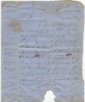
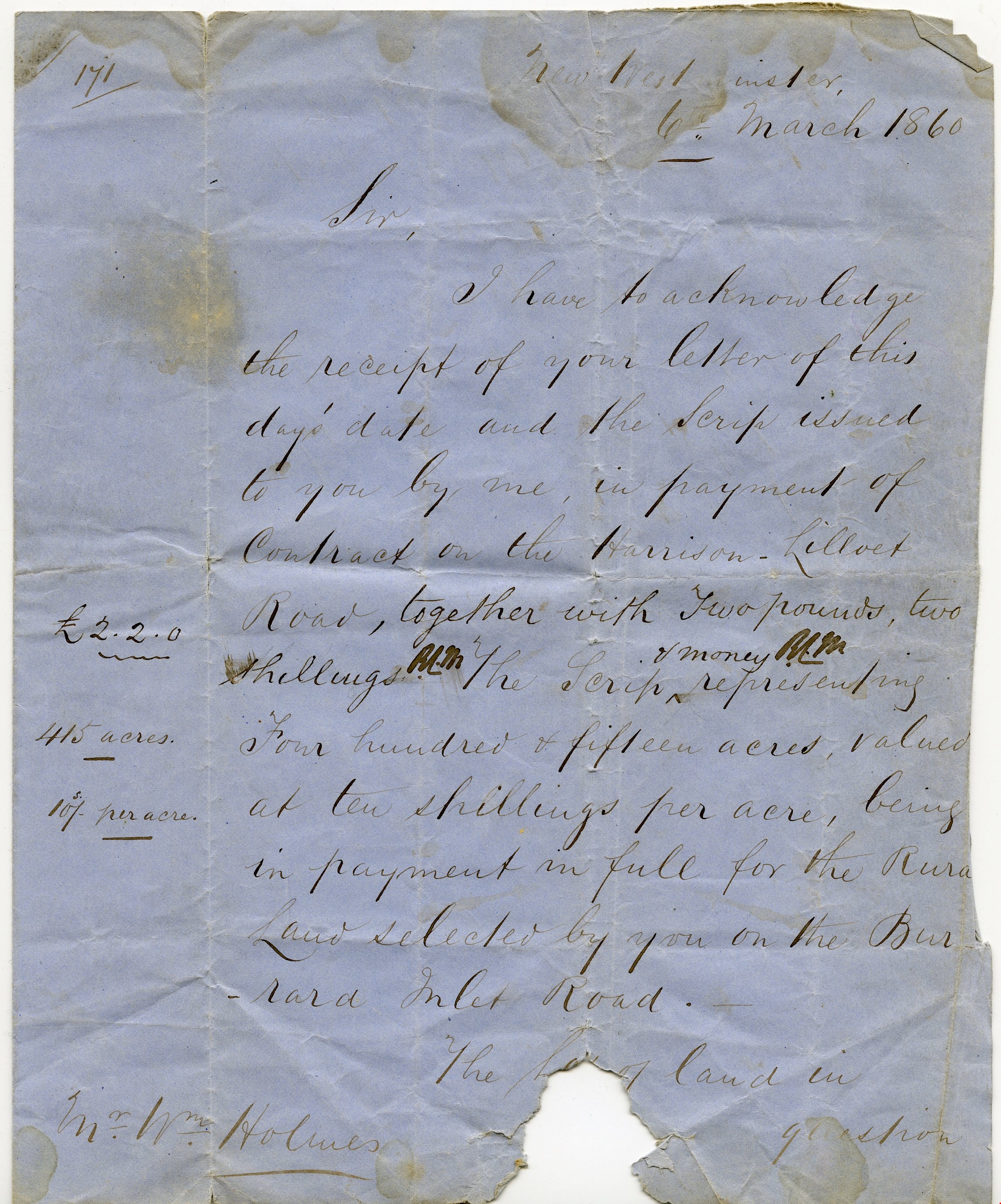
Letter re payment of Lot No. 1, Group 1, New Westminster District
https://search.heritageburnaby.ca/link/museumdescription10404
- Repository
- Burnaby Village Museum
- Date
- 6 Mar. 1860
- Collection/Fonds
- William Holmes fonds
- Description Level
- Item
- Physical Description
- 1 p. textual record ; folded
- Scope and Content
- Item consists of a handwritten letter on blue paper dated "6th March 1860". The letter is addressed to Mr. Wm. Holmes from Colonel Moody regarding payment of a contract on Harrison Lilloet Road and two pounds two shillings scrip payment for land on Burrard Inlet Road..."Lot No. 1, Group 1, Rural La…
- Repository
- Burnaby Village Museum
- Collection/Fonds
- William Holmes fonds
- Description Level
- Item
- Physical Description
- 1 p. textual record ; folded
- Scope and Content
- Item consists of a handwritten letter on blue paper dated "6th March 1860". The letter is addressed to Mr. Wm. Holmes from Colonel Moody regarding payment of a contract on Harrison Lilloet Road and two pounds two shillings scrip payment for land on Burrard Inlet Road..."Lot No. 1, Group 1, Rural Land, New Westminster District..."
- Accession Code
- BV997.50.3
- Access Restriction
- No restrictions
- Reproduction Restriction
- No known restrictions
- Date
- 6 Mar. 1860
- Media Type
- Textual Record
- Scan Resolution
- 300
- Scan Date
- 06-May-2019
- Notes
- Title based on contents of item
Images

Certificate of Title
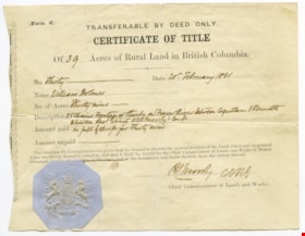
https://search.heritageburnaby.ca/link/museumdescription10407
- Repository
- Burnaby Village Museum
- Date
- 20 Feb. 1861
- Collection/Fonds
- William Holmes fonds
- Description Level
- Item
- Physical Description
- 1 certificate
- Scope and Content
- Item consists of "Certificate of Title" to Mr. William Holmes for land in Burnaby/NE Westminster; "39 Acres", "20th February 1861". "Description" reads: "25 Chains Frontage on thereby on Fraser River between Coquitlam & Brunette / between Rev. E. White & Col. Moody's [?]". The blue Provincial seal…
- Repository
- Burnaby Village Museum
- Collection/Fonds
- William Holmes fonds
- Description Level
- Item
- Physical Description
- 1 certificate
- Scope and Content
- Item consists of "Certificate of Title" to Mr. William Holmes for land in Burnaby/NE Westminster; "39 Acres", "20th February 1861". "Description" reads: "25 Chains Frontage on thereby on Fraser River between Coquitlam & Brunette / between Rev. E. White & Col. Moody's [?]". The blue Provincial seal is affixed to the certificate and it is signed by R.C. Moody, "Chief Commissioner of Lands and Works".
- Accession Code
- BV997.50.5
- Access Restriction
- No restrictions
- Reproduction Restriction
- No known restrictions
- Date
- 20 Feb. 1861
- Media Type
- Textual Record
- Scan Resolution
- 300
- Scan Date
- 06-May-2019
- Notes
- Title based on contents of item
Images
Certificate of Title
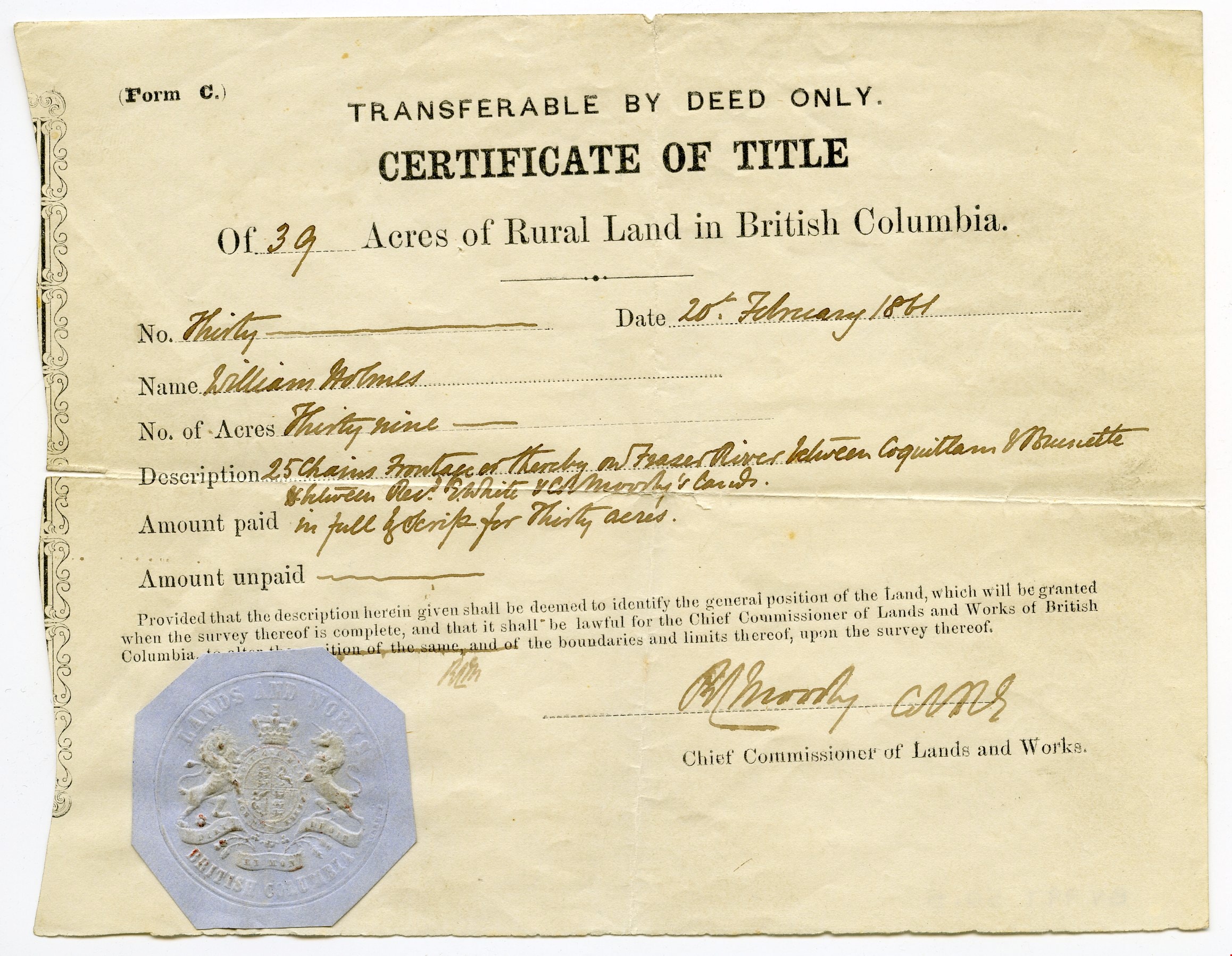
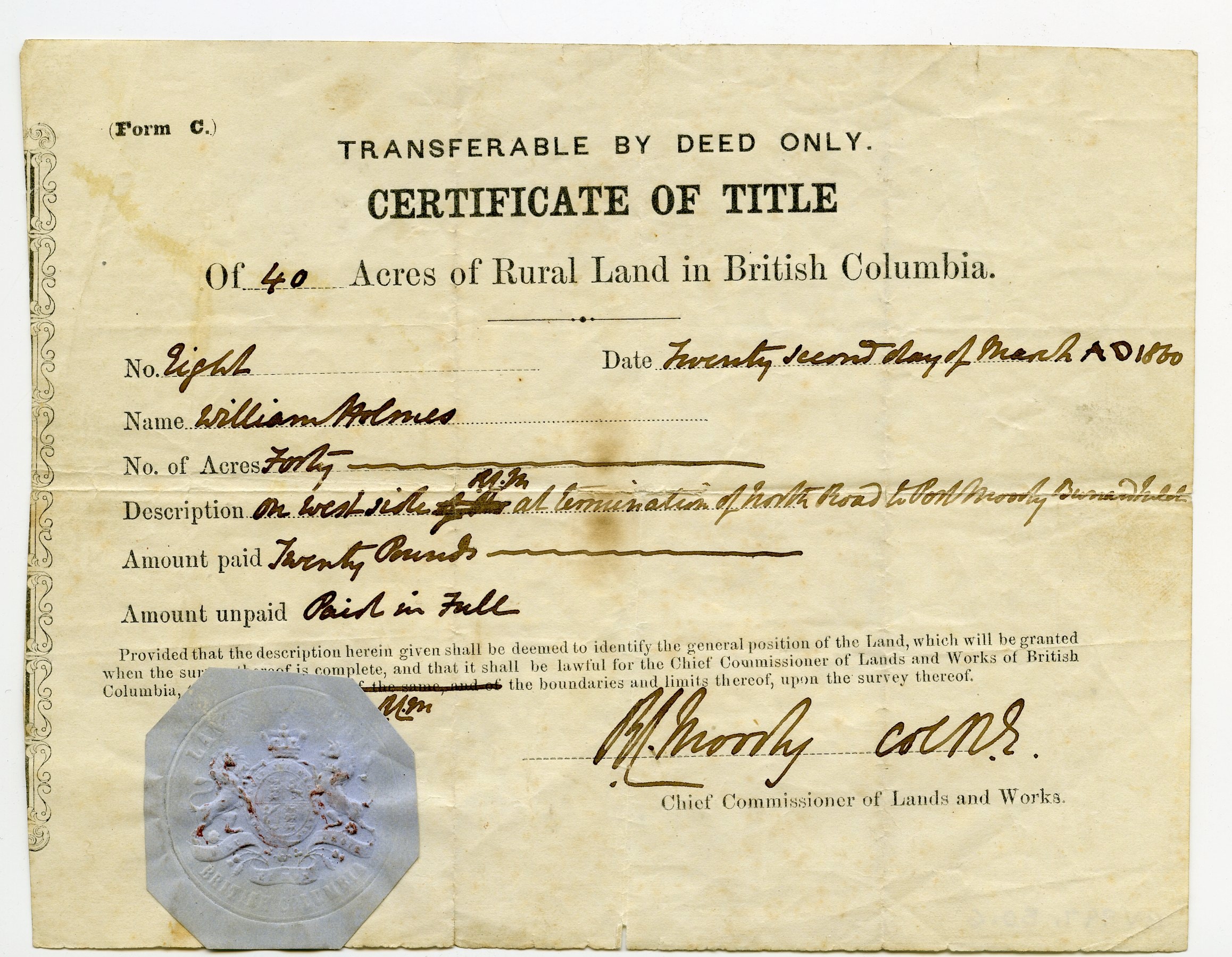
https://search.heritageburnaby.ca/link/museumdescription10408
- Repository
- Burnaby Village Museum
- Date
- 22 Mar. 1860
- Collection/Fonds
- William Holmes fonds
- Description Level
- Item
- Physical Description
- 1 certificate
- Scope and Content
- Item consists of "Certificate of Title" to Mr. William Holmes for land in Burnaby/NE Westminster; "40 Acres", "Twenty Second Day of March AD 1860". Description reads: "On West Side at termination of North Road to Port Moody Burrard Inlet". The blue Provincial seal is affixed to the certificate and…
- Repository
- Burnaby Village Museum
- Collection/Fonds
- William Holmes fonds
- Description Level
- Item
- Physical Description
- 1 certificate
- Scope and Content
- Item consists of "Certificate of Title" to Mr. William Holmes for land in Burnaby/NE Westminster; "40 Acres", "Twenty Second Day of March AD 1860". Description reads: "On West Side at termination of North Road to Port Moody Burrard Inlet". The blue Provincial seal is affixed to the certificate and it is signed by R.C. Moody, "Chief Commissioner of Lands and Works".
- Accession Code
- BV997.50.6
- Access Restriction
- No restrictions
- Reproduction Restriction
- No known restrictions
- Date
- 22 Mar. 1860
- Media Type
- Textual Record
- Scan Resolution
- 300
- Scan Date
- 06-May-2019
- Notes
- Title based on contents of item
Images
Certificate of Title
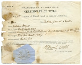
https://search.heritageburnaby.ca/link/museumdescription10409
- Repository
- Burnaby Village Museum
- Date
- 22 Mar. 1860
- Collection/Fonds
- William Holmes fonds
- Description Level
- Item
- Physical Description
- 1 certificate
- Scope and Content
- Item consists of "Certificate of Title" to Mr. William Holmes for land in Burnaby/NE Westminster; "68 Acres", "Tenth Day of March AD 1860". Description reads: "On West Side of North Road to Port Moody Burrard Inlet, shown on the [?] Plan as Lots 2 / Group 1". The blue Provincial seal is affixed to…
- Repository
- Burnaby Village Museum
- Collection/Fonds
- William Holmes fonds
- Description Level
- Item
- Physical Description
- 1 certificate
- Scope and Content
- Item consists of "Certificate of Title" to Mr. William Holmes for land in Burnaby/NE Westminster; "68 Acres", "Tenth Day of March AD 1860". Description reads: "On West Side of North Road to Port Moody Burrard Inlet, shown on the [?] Plan as Lots 2 / Group 1". The blue Provincial seal is affixed to the certificate and it is signed by R.C. Moody "Chief Commissioner of Lands and Works".
- Accession Code
- BV997.50.7
- Access Restriction
- No restrictions
- Reproduction Restriction
- No known restrictions
- Date
- 22 Mar. 1860
- Media Type
- Textual Record
- Scan Resolution
- 300
- Scan Date
- 06-May-2019
- Notes
- Title based on contents of item
Images
William Holmes fonds
https://search.heritageburnaby.ca/link/museumdescription10416
- Repository
- Burnaby Village Museum
- Date
- [1841]-1994
- Collection/Fonds
- William Holmes fonds
- Description Level
- Fonds
- Physical Description
- 2 photographs (calotype) + 1 photograph : b&w + 6 photographs : col. + 5 p. textual records + 1 newspaper clipping
- Scope and Content
- Fonds consists of photographs pertaining to the William Holmes family, family grave markers in cemetery in Ireland along with original correspondence, land title certificates and a newspaper clipping. Fonds is arranged in series: 1) William Holmes family photographs series 2) William Holmes family…
- Repository
- Burnaby Village Museum
- Collection/Fonds
- William Holmes fonds
- Description Level
- Fonds
- Physical Description
- 2 photographs (calotype) + 1 photograph : b&w + 6 photographs : col. + 5 p. textual records + 1 newspaper clipping
- Scope and Content
- Fonds consists of photographs pertaining to the William Holmes family, family grave markers in cemetery in Ireland along with original correspondence, land title certificates and a newspaper clipping. Fonds is arranged in series: 1) William Holmes family photographs series 2) William Holmes family records series 3) Holmes family cemetery photographs series
- History
- William Holmes was the first non-Indigenous resident of Burnaby and was born in Kilkenny Ireland January 4, 1812. In 1833, at the age of 20 yrs, William Holmes immigrated to Canada from Ireland in with his parents, Joseph and Jane (McCullough) Holmes and ten other family members including two of his married brothers and their wives, two sisters with their husbands and two unmarried brothers. This was the first group of thirteen to leave Ireland and set up homesteads in Canada near the shores of Lake Huron. The family settled on land concessions in Huron County, Ontario about 14 km southeast of Goderich. The area in Huron County was first founded in 1832 by John and Samuel Holmes and the community was known as Holmes Hill before becoming Holmesville [ca. 1850]. In 1837, William Holmes is noted as owning Lot 23, Concession IX, Goderich Twp. Much of the village of Holmesville grew up around the five road concession near the border of his brother’s farm so William decided to open a store. The Holmesville post office opened on March 1, 1855 and William was appointed the first post master which he operated until May 1857. William met and married Mary Richardson in 1841 and the couple had three daughters: Jane (1844-1926) (married Charles Studdert Finlaison in New Westminster in 1863); Anne Maria (Annie) (1846-192?) (married John Gunther Jennings in New Westminster in 1865 and married Robert Johnson in New Westminster in 1877) and Elizabeth (1848-1934) (married Thomas Carrington of Lakes District in 1867). William’s wife, Mary (Richardson) Holmes died in Holmesville sometime between 1848 and 1853. Following the death of his first wife, Mary, William married Charlotte McCullough (McCulloch). The couple had four daughters; Arabella Charlotte Amelia (1854-1943) (married Arthur Robert Green in 1887); Laura (1855-1867); Arabella Henrietta (1857-1929) (married Clark Wesley Gillanders in 1880) and Mary (1863-1864). During the late 1850s, William became aware of the gold rush and opportunities opening up in British Columbia so left for the west coast in 1858 at the age of 46 yrs. In preparation for his move to the west coast of Canada, William obtained a letter of introduction from top government officials of Canada. William Holmes arrived in British Columbia in 1859. Upon arriving, he first worked running pack trains from Harrison Mills to Lillooet. After earning some money, he decided to re-invest it in land. His first pre-emption of land occurred on January 21, 1860 for 160 acres situated on North Road from the Military Camp to Burrard Inlet and distancing 25 chains south of the Brunette River and 20 chains south of the river with the land extending in a westerly direction. On March 17, 1860, Holmes received a Crown Grant for this and other land in the immediate area totalling 415 acres of which was known as Lot No. 1, Group 1, Rural Land, New Westminster District. The balance of land was situated on the east side of the Brunette River – Lot 13, with 344 2/3 acres of which he made an application to purchase on June 26, 1860, and a Crown Grant dated March 16, 1861 covering 86 acres. Holmes also pre-empted land in Port Moody and Pitt Meadows in 1860 and 1861. The name of “Brunette River” is officially attributed to William Holmes who referred to the river as “Brunette” due to it’s dark colour originating from the peat lands above the lake. Following his purchase of property, he sent for his wife Charlotte, their three daughters and her three step daughters (from William’s first marriage). Charlotte and the six children made the long trip to B.C. by ship and rail, crossing the Isthmus of Darien at Panama. They arrived in B.C. in October 1861 and moved into a one room log cabin built by William. The cabin stood on the North Road at the foot of Sapperton, on a bluff overlooking the Brunette River. Eventually the family moved to a larger dwelling but the original cabin remained on the site until the 1890s when it was burned after being used as a sick house. Mr. Holmes was instrumental in organizing the first Orange Lodge in British Columbia. He was a prominent Orangeman who joined the order in 1840 and was the first master in the order of the City of New Westminster when the Lodge No. 1150 was established there. Charlotte Holmes died in New Westminster in 1893 at the age of 70 years and William Holmes died in New Westminster September 11, 1907 at the age of 95 years.
- Responsibility
- Holmes, William
- Accession Code
- HV971.46
- BV997.50
- Date
- [1841]-1994
- Media Type
- Photograph
- Textual Record
- Related Material
- See also: Reference file: Persons - Holmes, William
- Notes
- Title based on contents of fonds
![Interview with Josephine Chow by Denise Fong February 7, 2020, [1900-2020] (interview content), interviewed Feb. 7, 2020 thumbnail](/media/hpo/_Data/_BVM_Images/2017/2017_0036_0004_001.jpg?width=280)
Interview with Josephine Chow by Denise Fong February 7, 2020
https://search.heritageburnaby.ca/link/museumdescription12337
- Repository
- Burnaby Village Museum
- Date
- [1900-2020] (interview content), interviewed Feb. 7, 2020
- Collection/Fonds
- Burnaby Village Museum fonds
- Description Level
- Item
- Physical Description
- 1 sound recording (mp3) (00:43:19 min.)
- Scope and Content
- Recording consists of an interview with Josephine Chow (nee Hong) conducted by BVM researcher Denise Fong at the Burnaby Village Museum. Josephine describes her family history and recollects her childhood experiences in 1950s and 60s while growing with her family on their "Hop On" farm in Burnaby. …
- Repository
- Burnaby Village Museum
- Collection/Fonds
- Burnaby Village Museum fonds
- Series
- Museum Oral Histories series
- Subseries
- Chinese Canadians in Burnaby subseries
- Description Level
- Item
- Physical Description
- 1 sound recording (mp3) (00:43:19 min.)
- Material Details
- Interviewer: Denise Fong Interviewee: Josephine Chow Location of Interview: Burnaby Village Museum Interview Date: February 7, 2020 Total Number of Tracks: 1 Total Length of all Tracks: 00:43:19
- Scope and Content
- Recording consists of an interview with Josephine Chow (nee Hong) conducted by BVM researcher Denise Fong at the Burnaby Village Museum. Josephine describes her family history and recollects her childhood experiences in 1950s and 60s while growing with her family on their "Hop On" farm in Burnaby. The farm is situated in the Big Bend area along Marine Drive and is still in operation today. 0:00-08:45 Josephine Chow provides some historical background on the history of “Hop On Farm” and her family in British Columbia. She tells of how her grandfather Gay Tim Hong and three partners pooled money together to purchase twelve acres on Marine Drive in 1951. Prior to this, most of them farmed on the ʷməθkʷəy̓əm (Musqueam) First Nation Reserve for 20-30 years. It all began when her great grandfather Sui Wing Hong, first came to Canada from China and slowly brought over her grandfather, father and other members of the family. Her grandfather, Gay Tim Hong went back and forth between Canada and China at least four times since he and her grandmother had four children including her father, who was born in 1931. Her father came to Canada at 10 years of age to live with his father. Josephine’s great grandfather came to Vancouver from Zhongshan county in Canton Province (also known as Guangdong). 8:46- 14:20 Josephine provides the names of her siblings from the eldest to the youngest; Pauline, Josephine (herself), Catherine, Noreen, Gary, Darlene and Marlene. She describes what life was like on the farm with her parents working from sunrise to sunset. The family farmed vegetable produce taking orders from local stores in the lower mainland. Often the children helped their parents with the orders starting at eight or nine years of age. Other workers on the farm travelled by bus from Vancouver’s Chinatown. She also tells of how her father was an animal lover and raised chickens, pigeons, geese, koy, goldfish and dogs. 14: 21 – 16:56 Josephine describes what Burnaby was like during the time that she grew up in the late 1950s. She explains that Burnaby was very quiet with nothing being open on Sundays. On the farm, she and her siblings would entertain themselves by playing games like soccer, baseball and kick ball or also by catching frogs, snails, caterpillars and ladybugs. There were neighbours living on Marine Drive and almost every house had someone who we went to the same elementary school. The neighbourhood children would often come to play with them on their farm. 16:56- 26:47 Josephine describes how when they were young there were farms all around them and how on Sunday drives with her father, they would go to feed horses or look at the cows. Josephine shares that her elder sister Pauline was the only one born in China and how when she first arrived that she lived on the ʷməθkʷəy̓əm (Musqueam) First Nations Reserve with their parents before they moved to Burnaby. Josephine recollects that most of her friends were farmer’s kids from the neighbourhood but while in school, she had more Caucasian friends. Josephine and her siblings attended Glenwood Elementary on Marine Drive and later Junior Secondary at McPherson Park (grades 8-10) and Burnaby South Senior Secondary (grades 11-12. ). She shares some of her experiences while attending school. She said that there were about a dozen Asians in school with her, mostly from farming families in the “Flats”. 26:48- 30:45 Josephine describes what life was like for her and her siblings after school. They often helped on the farm when they got home, usually taking care of orders for green onions. Her mother made dinner and did all of the cooking for family and workers on the farm as well as working in the fields. Her father did all of the grocery shopping in Vancouver’s Chinatown two or three times per week where he purchased meat and fish. She says that her grandfather, often travelled by bus every Saturday or Sunday to meet up with friends in Chinatown. Extracurricular activities for her and her siblings included volley ball and soccer as long as it didn’t interfere with their work schedule on the farm. 30:46- 37:03 Josephine describes what occurred while living at home, the food they ate, shopping and attending Chinese school. Her mother cooked only Chinese food, she didn’t know how to cook “Western food”. For school lunches, the kids made their own sandwiches. She tells of a Chinese language school arranged by Mrs. Joe [sic] who lived on Gilley Road and was Canadian born Chinese. Mrs. Joe [sic] also arranged an English class for farmer’s wives on Tuesday nights in which her mother attended. Josephine recollects learning Mandarin from Mrs. Joe [sic] a few days a week after her regular school. Chinese school took place at Riverway School on Meadow Avenue in Burnaby. Mrs. Joe also taught them a lot about Chinese culture including Kung Fu, Chinese Dance and Chinese brush painting. 37:04- 39:39 Josephine describes Medical Care for her and her family in the 1950s and 1960s. She tells of a female Chinese doctor in Vancouver, Dr. Madeline Chung. Dr. Chung was responsible for delivering a lot of Chinese babies including Josephine. The family also visited herbalists in Vancouver Chinatown. They would often buy herbs for colds etc. Josephine also tells of how her parents stayed in touch with family in China by writing letters. Her mother’s family, including her parents and siblings were still in China while most of her father’s family were here in Canada. 39:40- 43:19 – In closing, Josephine shares how life is much busier now and of how she misses the quietness of her days growing up. She briefly describes her life on the family farm now and how different it is from when her parents worked the farm. She explains how farming methods have changed and how they don’t have to work as hard as her parents did.
- History
- Interviewee biography: Josephine Chow (nee Hong) is the second eldest child of Chan Kow Hong and Sui Ha Hong. In 1925, Josephine's grandfather, Gay Tim Hong immigrated to Canada from Zhongshan county in Canton Province (also known as Guangdong). In 1952, her father, Chan Kow Hong joined his father, Gay Tim Hong and by 1953, he established "Hop On Farms" in the Big Bend area of Burnaby near Marine Drive. Josephine grew up on the farm with her parents and six siblings; Pauline, Catherine, Norine, Gary, Darlene and Marlene. In 1969, Josephine's elder sister Pauline and her husband Jack Chan took over the family farm and in 1972 their father and grandfather moved to Kamloops to open a restaurant. As an adult, Josephine worked in several different areas including owning and running her own Aesthetics business. Josephine eventually retired and returned to the farm to assist her siblings. The farm is still in operation. Interviewer biography: Denise Fong is a historical researcher at Burnaby Village Museum. She has degrees in Anthropology (BA) and Archaeology (MA), and is completing her doctoral degree at UBC in Interdisciplinary Studies. Her primary research interests are in Chinese Canadian history and critical heritage studies. She is the co-curator of BVM’s “Across the Pacific” exhibition, and the Museum of Vancouver’s “A Seat at the Table – Chinese Immigration and British Columbia”.
- Creator
- Burnaby Village Museum
- Subjects
- Persons - Chinese Canadians
- Agriculture - Farms
- Education
- Buildings - Schools
- First Nations reserves - British Columbia
- Names
- Chow, Josephine
- Glenwood Elementary School
- McPherson Park Junior Secondary School
- ʷməθkʷəy̓əm (Musqueam)
- Responsibility
- Fong, Denise
- Geographic Access
- Byrne Road
- Accession Code
- BV020.6.1
- Access Restriction
- No restrictions
- Reproduction Restriction
- No known restrictions
- Date
- [1900-2020] (interview content), interviewed Feb. 7, 2020
- Media Type
- Sound Recording
- Historic Neighbourhood
- Fraser Arm (Historic Neighbourhood)
- Planning Study Area
- Big Bend Area
- Related Material
- See also BV017.36*
- Scan Resolution
- 600
- Scan Date
- 12/3/2017
- Scale
- 100
- Notes
- Title based on contents of interview
- Photograph info: Gary Hong and Chan Kow Hong harvesting celery at Hop-On Farms [1969]. BV017.36.4
Images
![Interview with Josephine Chow by Denise Fong February 7, 2020, [1900-2020] (interview content), interviewed Feb. 7, 2020 thumbnail](/media/hpo/_Data/_BVM_Images/2017/2017_0036_0004_001.jpg)
Audio Tracks
Interview with Josephine Chow by Denise Fong February 7, 2020, [1900-2020] (interview content), interviewed Feb. 7, 2020
Interview with Josephine Chow by Denise Fong February 7, 2020, [1900-2020] (interview content), interviewed Feb. 7, 2020
https://search.heritageburnaby.ca/media/hpo/_Data/_BVM_Sound_Recordings/Oral_Histories/2020_0006_0001_001.mp3![Interview with Julie Lee by Denise Fong February 6, 2020, [1920-1992] (interview content), interviewed Feb. 6, 2020 thumbnail](/media/hpo/_Data/_BVM_Images/2017/2017_0024_0027_001.jpg?width=280)
Interview with Julie Lee by Denise Fong February 6, 2020
https://search.heritageburnaby.ca/link/museumdescription12338
- Repository
- Burnaby Village Museum
- Date
- [1920-1992] (interview content), interviewed Feb. 6, 2020
- Collection/Fonds
- Burnaby Village Museum fonds
- Description Level
- Item
- Physical Description
- 1 sound recording (mp3) (00:53:46 min.)
- Scope and Content
- Recording consists of an interview with Julie Lee conducted by Burnaby Village Museum researcher Denise Fong. Julie Lee shares information about her mother, Suey Ying Jung's (Laura's) experiences growing up as a Chinese Canadian on a farm in Burnaby during the 1920s and 1930s. She also shares some …
- Repository
- Burnaby Village Museum
- Collection/Fonds
- Burnaby Village Museum fonds
- Series
- Museum Oral Histories series
- Subseries
- Chinese Canadians in Burnaby subseries
- Description Level
- Item
- Physical Description
- 1 sound recording (mp3) (00:53:46 min.)
- Material Details
- Interviewer: Denise Fong Interviewee: Julie Lee Location of Interview: Home of Julie and Cecil Lee Interview Date: February 6, 2020 Total Number of Tracks: 1 Total Length of all Tracks: 00:53:46
- Scope and Content
- Recording consists of an interview with Julie Lee conducted by Burnaby Village Museum researcher Denise Fong. Julie Lee shares information about her mother, Suey Ying Jung's (Laura's) experiences growing up as a Chinese Canadian on a farm in Burnaby during the 1920s and 1930s. She also shares some information about her father Puy Yuen Chan. 0:00- 01:47 Julie Lee provides background information on her families’ connection to Burnaby and conveys how her maternal grandparents farmed a five acre lot at Still Creek and Douglas Road. Her grandparents grew vegetable produce and operated a piggery at this location. Her mother, Suey Ying Jung (Laura) was the middle child between two older sisters, Maida and Annie and her two younger brothers Gordon and Harry. They were all born at home and educated at Edmonds Elementary School. 01:48- 11:47 Julie provides some background information about her mother, the friendships she made growing up, when she got married and places that she lived. She tells of her mother marrying in 1942 at age 30 years, moving to Fraser Mills and then onto Maillardville in 1958. There was easy access to the Interurban tram so her mother was able to have a social life with others in Vancouver’s Chinatown. She says that many of the only existing photographs of the family living on the farm at Still Creek and Douglas Road can be attributed to her mother’s friend Lil Mau [sic] who owned a camera. The farm was sold around 1949 when her grandparents moved to East Vancouver. While operating the farm, her grandparents only hired Chinese workers who spoke the same language and ate the same foods as them. Despite this, her grandparents made friends with the Collin’s family who assisted them in adjusting to the Canadian way of life. Julie tells that her mother’s sister Maida and brother in law lived with them at Fraser Mills. Her mother’s sister Maida had nine children so Julie’s mother helped her in raising them. 11:48 – 16:53 - Julie talks about racial prejudice towards the Chinese in Burnaby during the 1920s and 1930s. She says that for the most part, her mother’s family had a very insular life on the farm and mainly socialized only within the Chinese community. Julie tells of how she recently became aware of a memoir “The Way it Was”, written by Burnaby resident, Fannie Waplington. The memoir is held as part of the Burnaby Village Museum collection. In the memoir, Fannie Waplington tells of how she was forbidden from visiting Julie’s mother on their farm due to her ethnic background. Julie conveys that it seems like it was a missed friendship for both her mother and Fannie. 16:54 – 22:30 Julie describes what school life was like for her mother and what she may have done outside of school. Her mother attended Edmonds School in the 1920s up to Grade 7 or Grade 8. Julie explains that Asian girls were never offered the opportunity to pursue higher education while her mother’s brothers continued with their education attending Vancouver Technical School. Her mother continued to work on the farm until she was married cooking for workers and helping her mother. Outside of school, she may have helped with looking after nieces and nephews, played cards and mahjong. She says that her mother continued to play cards with her own children and was a skilled knitter into her 80s. 22:31 – 30: 53 Julie tells of what she knows about the Chinese workers on the farm and Fraser Mills and what they did on the weekends. She figures that many may have played card games to pass the time and at Fraser Mills gambling occurred. Fishing was a highlight for her father and she recalls him fishing sturgeon. Single workers may have gone into Vancouver on the weekends. Julie says that her parents had a hobby farm while living at Fraser Mills and that they grew enough garlic to sell in Chinatown. She thinks that before living at Fraser Mills, her mother must have went to Chinatown quite a bit, assisting with banking and enjoying a social life. Julie shares that her father, Puy Yuen Chan came to Canada from China at twelve years of age but working as a shingle packer, he never learned to speak English. She figures that her parents must have met at Fraser Mills while her mother was visiting her sister Maida. 30:54 – 37:33 Julie describes her mother as the cook, caregiver and the “one man show”. She says that her mother enjoyed cooking traditional Chinese recipes. Julie talks of her own cooking and gardening skills which she may have inherited from her parents including her large patch of garlic. 37:34- 40:23- Julie is asked as to whether her mother attended Chinese school and says that she had some Chinese schooling. She could read and write a little but didn’t attend a formal school as far as she knows. Julie shares some background information on her own husband Cecil, who grew up in East Vancouver. She shares that Cecil’s family went back to China from 1931 until 1939 when they returned to Queensborough. Cecil attended Chinese school in New Westminster. 40:24 – 42:19 Julie speaks briefly about what type of medical care her mother and her family had. She relates that all births took place at home and they accessed a Chinese herbalist in Chinatown. Hospitals were accessed in 1950s—1960s. The family did use Western doctors that were insured under the medical system. She recalls growing up and having to drink a particular herbal brew at least once a month to stay well. 42:20- 46:47 Julie describes how her parents stayed connected with their families in China. She says that her mother’s family didn’t stay in touch with relatives in China and that her uncles rejected anything to do with the past. On her father’s side they maintained a connection with cousins. She recalls that her father, Puy Yuen Chan supported some of his relatives back home in China and stayed in touch with some. Her mother, Laura travelled to China in 1991 and 1992 and connected with some relations on Julie’s father’s side. 46:48- 53:46 In this segment, Julie speaks of her mother’s character being very self-assured, independent and goal oriented. She feels that her mother valued being surrounded by her family and friends and felt very comfortable growing up in Burnaby and with the relationships that she had. She feels that her mother adapted to her roles being the last of four children on the farm and that she was very self-sufficient and determined.
- History
- Interviewee biography: Julie Lee (nee Chan) is the daughter of Suey Ying Jung (Laura) and Puy Yuen Chan. Her mother's family owned and operated a vegetable and piggery farm on Douglas Road near Still Creek in the early 1900s. Their farm was located in front of the Douglas Road interurban tram station. Her mother had two older sisters named Maida and Annie and two younger brothers Harry and Gordon. Her mother was born in 1912 and left the farm for Fraser Mills when she was married in 1942. Julie grew up with her parents and siblings on the Fraser Mills site during the 1940s and 1950s. Interviewer biography: Denise Fong is a historical researcher at Burnaby Village Museum. She has degrees in Anthropology (BA) and Archaeology (MA), and is completing her doctoral degree at UBC in Interdisciplinary Studies. Her primary research interests are in Chinese Canadian history and critical heritage studies. She is the co-curator of BVM’s “Across the Pacific” exhibition, and the Museum of Vancouver’s “A Seat at the Table – Chinese Immigration and British Columbia”.
- Creator
- Burnaby Village Museum
- Names
- Lee, Julie Cho Chan
- Chan, Puy Yuen
- Jung, Suey Ying "Laura"
- Wong, Suey Fong "Maida" Jung
- Jung, Suey Cheung "Harry"
- Jung, Suey Yook "Gordon"
- Jung, Gee Shee
- Jung, Chung Chong
- Jong, Suey Kin "Annie" Jung
- Responsibility
- Fong, Denise
- Geographic Access
- Douglas Road
- Accession Code
- BV020.6.2
- Access Restriction
- No restrictions
- Reproduction Restriction
- No known restrictions
- Date
- [1920-1992] (interview content), interviewed Feb. 6, 2020
- Media Type
- Sound Recording
- Historic Neighbourhood
- Burnaby Lake (Historic Neighbourhood)
- Planning Study Area
- Douglas-Gilpin Area
- Related Material
- See also BV018.16.1
- Scan Resolution
- 1000
- Scan Date
- 01-Oct-2017
- Scale
- 96
- Notes
- Title based on contents of interview
- Photograph info: Suey Ying (Laura) with produce baskets [between 1940 and 1942]. BV017.24.27
Images
![Interview with Julie Lee by Denise Fong February 6, 2020, [1920-1992] (interview content), interviewed Feb. 6, 2020 thumbnail](/media/hpo/_Data/_BVM_Images/2017/2017_0024_0027_001.jpg)
Audio Tracks
Interview with Julie Lee by Denise Fong February 6, 2020, [1920-1992] (interview content), interviewed Feb. 6, 2020
Interview with Julie Lee by Denise Fong February 6, 2020, [1920-1992] (interview content), interviewed Feb. 6, 2020
https://search.heritageburnaby.ca/media/hpo/_Data/_BVM_Sound_Recordings/Oral_Histories/2020_0006_0002_001.mp3