Narrow Results By
Decade
- 2020s 62
- 2010s 95
- 2000s 121
- 1990s 190
- 1980s 199
- 1970s 269
- 1960s 172
- 1950s 166
- 1940s 146
- 1930s 183
- 1920s 563
- 1910s 684
- 1900s 533
- 1890s 229
- 1880s 103
- 1870s 35
- 1860s 34
- 1850s 14
- 1840s 11
- 1830s 6
- 1820s 3
- 1810s 3
- 1800s 6
- 1790s 2
- 1780s 1
- 1770s 1
- 1760s 1
- 1750s 1
- 1740s 1
- 1730s 1
- 1720s 1
- 1710s 3
- 1700s 2
- 1690s 1
- 1680s 2
- 1670s 1
- 1660s 1
- 1650s 1
- 1640s 1
- 1630s 1
- 1620s 1
- 1610s 1
- 1600s 1
Creator
- A. A. Marks (firm) 1
- Abbott, George Knapp, 1880-1959 1
- Abbott, Jacob, 1803-1879 1
- Abraham, Dorothy, 1894- 1
- Ackerknecht, Erwin H. (Erwin Heinz), 1906-1988 1
- Adams, Albert Egerton 1
- Adams, Beth 1
- Adams, Beverley 1
- Adams, Edith 2
- Adams, George Burton, 1851-1925 1
- Adams, John 2
- Adams, John, 1926-1998 1
Century Park Museum Association fonds
https://search.heritageburnaby.ca/link/museumdescription3781
- Repository
- Burnaby Village Museum
- Date
- 1971-1989
- Collection/Fonds
- Century Park Museum Association fonds
- Description Level
- Fonds
- Physical Description
- 1814 photographs + 219 architectural drawings + 17 technical drawings + 4 videocassettes + 3 audio reels + 17 audio cassettes + 1.6 m of textual records + 2 maps
- Scope and Content
- Fonds consists of records created and collected by the Century Park Museum Association (renamed Burnaby Village Museum Association after 1984), which managed Heritage Village (later named Burnaby Village Museum) from its opening in 1971 until it's dissolution in December 1989. Records include archi…
- Repository
- Burnaby Village Museum
- Collection/Fonds
- Century Park Museum Association fonds
- Description Level
- Fonds
- Physical Description
- 1814 photographs + 219 architectural drawings + 17 technical drawings + 4 videocassettes + 3 audio reels + 17 audio cassettes + 1.6 m of textual records + 2 maps
- Scope and Content
- Fonds consists of records created and collected by the Century Park Museum Association (renamed Burnaby Village Museum Association after 1984), which managed Heritage Village (later named Burnaby Village Museum) from its opening in 1971 until it's dissolution in December 1989. Records include architectural drawings and proposals; photographs and films of the site; documentation of exhibits and artifacts, special events and programs; oral history interviews and other sound recordings; association meeting minutes; constitutions and bylaws; financial records; reports; correspondence; publications and research materials. Fonds has been arranged into the following series: 1) Century Park Museum Association photograph collection series 2) Century Park Museum Association film collection series 3) Century Park Museum Association architectural records and reports series 4) Heritage Village Museum oral history Interviews series 5) Heritage Village Museum presentations and Programming series 6) Century Park Museum Association reports series 7) Century Park Museum Association constitution, bylaws and agreements series 8) Century Park Museum Association minutes of meetings series 9) Century Park Museum association Board of Directors' administrative files series 10) Century Park Museum membership series 11) Heritage Village Museum exhibits and artifacts series 12) Century Park Museum Association committees' minutes and reports series 13) Museum staff adminstrative files series 14) Century Park Museum Association financial records series
- History
- The Heritage Village Museum was originally created as a British Columbia Centennial Project in 1971 through funding from the Federal, Provincial and Municipal governments. A sub-committee of the Burnaby Centennial '71 Committee was responsible for the creation of a permanent commemorative project. The concept for an open-air museum was developed with the location to be in Burnaby on lots 8,9, 10 and 11 of District Lot 79 and Lots 2 and 5, Block "R" of Districts Lots 79 and 85. The official sod turning for Heritage Village took place on April 11, 1971. In the spring of 1971, a museum director and curator were hired to oversee the development of the project and the acquisition of artifacts with funding from the Parks and Recreation Commission. The Century Park Museum Association (CPMA) was founded under the auspices of the Burnaby Centennial '71 Committee to govern Burnaby's Centennial '71 Commemorative Project, Heritage Village. The CPMA Board of directors were elected on October 26, 1971 with Donald (Don) Copan as the founding president (Don continued to serve on the Board until 1989). The Board of Directors reported directly to the Municipal Council. The association had an overall objective of providing a museum that was a historical resource for Burnaby and the region. The museum mandate was to collect, preserve, research, document and interpret artifacts and historical buildings that illustrated the history and lifestyle of the Lower Mainland in B.C. and Burnaby. The Museum focused on the period between 1890 and 1925 depicting a village lifestyle of a small community. This was achieved through the use of exhibits and displays within historic buildings and built reconstructions along with costumed museum interpreters. Many people contributed to the construction and design of the village. Architect, Rudy Kovach created the initial concept drawings and architecture designs were created by architectural design consultants Hopping, Kovach and Grinnell. Many carpenters and tradespeople worked on the construction of the buildings including Mr. Angelo Giacometti who was respsonible for much of the final decorative elements. The official opening of Heritage Village took place on November 19, 1971 with Burnaby Mayor Bob Prittie and Canada’s Governor General Roland Michener. Heritage Village was opened up to the public for a few days between November 19 and 21 with approximately 15,000 visitors. On July 1st, 1972 Heritage Village re-opened for the summer season with CPMA president, Don Copan and Mayor Bob Prittie officiating. This opening showcased further development of the site with more buildings and exhibits added. In 1984, Heritage Village Museum changed its name to “Burnaby Village Museum” and in turn, the Century Park Museum Association changed its name to the “Burnaby Village Museum Association”. Burnaby Village Museum continued to be governed by the Burnaby Village Museum Association until the end of 1989. In 1990, the Corporation of the District of Burnaby assumed the operation and management of Burnaby Village Museum under the Parks, Recreation and Cultural Services Department and the Burnaby Village Museum Association was dissolved.
- Responsibility
- Century Park Museum Association
- Accession Code
- BV985.6028
- BV005.14
- BV000.18
- BV011.44
- BV011.50
- BV014.30
- BV016.56
- BV017.46
- BV018.21
- BV019.52
- BV020.4
- BV020.5
- BV021.5
- BV022.9
- Date
- 1971-1989
- Media Type
- Photograph
- Sound Recording
- Textual Record
- Architectural Drawing
- Moving Images
- Cartographic Material
- Technical Drawing
- Related Material
- Donald Copan fonds
- Burnaby Centennial '71 Committee collection
- Royal Bank exhibit collection
- Bell's Dry Goods exhibit collection
- Jesse Love farmhouse fonds
- Burnaby Village Museum fonds
- Arrangement
- Records are arranged by types and functions of the Century Park Museum Association. The series reflects how they were maintained by the associaton, it's members and staff of Heritage Village (Burnaby Village Museum) while under the governance of the association.
- Notes
- Title based on contents of fonds
- Further accruals are expected
- Some records within this fonds are Closed - contact Burnaby Village Museum for access
![Planning Map of Chinese Market Gardens on Marine Drive, [between 1950 and 1959] (date of original), 2017 (date of duplication) thumbnail](/media/hpo/_Data/_BVM_Images/2017/2017_0040_0002_001.jpg?width=280)
Planning Map of Chinese Market Gardens on Marine Drive
https://search.heritageburnaby.ca/link/museumdescription4297
- Repository
- Burnaby Village Museum
- Date
- [between 1950 and 1959] (date of original), 2017 (date of duplication)
- Collection/Fonds
- Herbert Yee Law family fonds
- Description Level
- Item
- Physical Description
- 1 photograph (tiff) : col. ; 300 dpi
- Scope and Content
- Scanned copy of a survey plan of district lots 163, 162, 157, 158, and 165, near the Chinese Market Gardens along Marine Drive.
- Repository
- Burnaby Village Museum
- Collection/Fonds
- Herbert Yee Law family fonds
- Description Level
- Item
- Physical Description
- 1 photograph (tiff) : col. ; 300 dpi
- Scope and Content
- Scanned copy of a survey plan of district lots 163, 162, 157, 158, and 165, near the Chinese Market Gardens along Marine Drive.
- History
- Survey plan of district lots 163, 162, 157, 158, and 165, which is primarily the area farmed by Chinese and Chinese-Canadian market gardeners around Marine Drive between Royal Oak and Mandeville (present-day Nelson). Two Chinese/Chinese Canadian land owners can be seen on the map: N.G. Wah Sing (or Ng Wah Sing) and Yee Law (or Herbert Law).
- Geographic Access
- Marine Drive
- Accession Code
- BV017.40.2
- Access Restriction
- No restrictions
- Reproduction Restriction
- No known restrictions
- Date
- [between 1950 and 1959] (date of original), 2017 (date of duplication)
- Media Type
- Cartographic Material
- Historic Neighbourhood
- Fraser Arm (Historic Neighbourhood)
- Planning Study Area
- Big Bend Area
- Scan Resolution
- 300
- Scan Date
- 11/19/2017
- Scale
- 100
- Notes
- Title based on contents of copy scan of map
- Herbert Yee Law was donor's father and this map may have originally been his copy of the city planning/engineering documents.
Images
![Planning Map of Chinese Market Gardens on Marine Drive, [between 1950 and 1959] (date of original), 2017 (date of duplication) thumbnail](/media/hpo/_Data/_BVM_Images/2017/2017_0040_0002_001.jpg)

Film of Julie Lee discussing her family farm in the Big Bend area
https://search.heritageburnaby.ca/link/museumdescription4378
- Repository
- Burnaby Village Museum
- Date
- 6 Oct 2017
- Collection/Fonds
- Burnaby Village Museum fonds
- Description Level
- Item
- Physical Description
- 1 m4v video (13 min., 59 sec.) : digital, 23 fps, col., sd., stereo
- Scope and Content
- Film of Julie Lee discussing her family farm in the Big Bend area of Burnaby during a presentation as part of the "Chinese Canadian Stories" Lecture. This lecture was part of the Burnaby Neighbourhood History Series on October 4, 2017 at the Metrotown branch of the Burnaby Public Library. Julie Lee…
- Repository
- Burnaby Village Museum
- Collection/Fonds
- Burnaby Village Museum fonds
- Description Level
- Item
- Physical Description
- 1 m4v video (13 min., 59 sec.) : digital, 23 fps, col., sd., stereo
- Scope and Content
- Film of Julie Lee discussing her family farm in the Big Bend area of Burnaby during a presentation as part of the "Chinese Canadian Stories" Lecture. This lecture was part of the Burnaby Neighbourhood History Series on October 4, 2017 at the Metrotown branch of the Burnaby Public Library. Julie Lee discusses what life was like growing up on her family farm in the Douglas-Gilpin area, at the corner of Still Creek and Douglas Road in Burnaby.
- History
- Julie Lee is the daughter of Suey Ying Jung (Laura) and Puy Yuen Chan. The couple were married at Fraser Mills in October, 1942. The family owned a farm on Douglas Road near Still Creek in the early 1900s. Their farm was located in front of the Douglas Road interurban tram station.
- Subjects
- Agriculture - Farms
- Accession Code
- BV018.6.1
- Reproduction Restriction
- No known restrictions
- Date
- 6 Oct 2017
- Media Type
- Moving Images
- Historic Neighbourhood
- Burnaby Lake (Historic Neighbourhood)
- Planning Study Area
- Douglas-Gilpin Area
- Notes
- Title based on contents of film
Images

Video
Film of Julie Lee discussing her family farm in the Big Bend area, 6 Oct 2017
Film of Julie Lee discussing her family farm in the Big Bend area, 6 Oct 2017
https://search.heritageburnaby.ca/media/hpo/_Data/_BVM_Moving_Images/2018_0006_0001_001.m4v
Film of Ken Yip discussing his family farm in the Big Bend area
https://search.heritageburnaby.ca/link/museumdescription4379
- Repository
- Burnaby Village Museum
- Date
- 6 Oct 2017
- Collection/Fonds
- Burnaby Village Museum fonds
- Description Level
- Item
- Physical Description
- 1 m4v video (14 min., 57 sec.) : digital, 23 fps, col., sd., stereo
- Scope and Content
- Film of Ken Yip discussing his family farm in the Big Bend area of Burnaby during a presentation as part of the "Chinese Canadian Stories" Lecture. This lecture was part of the Burnaby Neighbourhood History Series on October 4, 2017 at the Metrotown branch of the Burnaby Public Library. Ken Yip dis…
- Repository
- Burnaby Village Museum
- Collection/Fonds
- Burnaby Village Museum fonds
- Description Level
- Item
- Physical Description
- 1 m4v video (14 min., 57 sec.) : digital, 23 fps, col., sd., stereo
- Scope and Content
- Film of Ken Yip discussing his family farm in the Big Bend area of Burnaby during a presentation as part of the "Chinese Canadian Stories" Lecture. This lecture was part of the Burnaby Neighbourhood History Series on October 4, 2017 at the Metrotown branch of the Burnaby Public Library. Ken Yip discusses what life was like growing up on his family farm in the Big Bend area, on Bryne Road in Burnaby.
- Accession Code
- BV018.6.2
- Reproduction Restriction
- No known restrictions
- Date
- 6 Oct 2017
- Media Type
- Moving Images
- Planning Study Area
- Big Bend Area
- Notes
- Title based on contents of film
Images
Video
Film of Ken Yip discussing his family farm in the Big Bend area, 6 Oct 2017
Film of Ken Yip discussing his family farm in the Big Bend area, 6 Oct 2017
https://search.heritageburnaby.ca/media/hpo/_Data/_BVM_Moving_Images/2018_0006_0002_001.m4v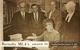
Eileen Dailly: Taking a Stand
https://search.heritageburnaby.ca/link/museumdescription4483
- Repository
- Burnaby Village Museum
- Date
- 2018
- Collection/Fonds
- Burnaby Village Museum fonds
- Description Level
- Item
- Physical Description
- 1 video recording (mp4) (3 min., 46 sec.) : digital, 23 fps, col., sd., stereo
- Scope and Content
- This short film was produced by the City of Burnaby Community Heritage Commission to commemorate Burnaby's 125th anniversary. It features the story of Burnaby MLA Eileen Dailly and her efforts to ban corporal punishment in BC public schools.
- Repository
- Burnaby Village Museum
- Collection/Fonds
- Burnaby Village Museum fonds
- Description Level
- Item
- Physical Description
- 1 video recording (mp4) (3 min., 46 sec.) : digital, 23 fps, col., sd., stereo
- Scope and Content
- This short film was produced by the City of Burnaby Community Heritage Commission to commemorate Burnaby's 125th anniversary. It features the story of Burnaby MLA Eileen Dailly and her efforts to ban corporal punishment in BC public schools.
- Publisher
- City of Burnaby
- Other Title Information
- Title given by film makers
- Names
- Dailly, Eileen
- Accession Code
- BV018.12.1
- Access Restriction
- No restrictions
- Reproduction Restriction
- May be restricted by third party rights
- Date
- 2018
- Media Type
- Moving Images
- Notes
- Transcribed title
- Reproduction of content is restricted
Images
Video
Eileen Dailly: Taking a Stand, 2018
Eileen Dailly: Taking a Stand, 2018
https://search.heritageburnaby.ca/media/hpo/_Data/_BVM_Moving_Images/2018_0012_0001_001.mp4
Burnaby’s Chinese Canadian Market Gardens
https://search.heritageburnaby.ca/link/museumdescription4484
- Repository
- Burnaby Village Museum
- Date
- 2018
- Collection/Fonds
- Burnaby Village Museum fonds
- Description Level
- Item
- Physical Description
- 1 video recording (mp4) (3 min., 15 sec.) : digital, 23 fps, col., sd., stereo
- Scope and Content
- This short film was produced by the City of Burnaby Community Heritage Commission to commemorate Burnaby's 125th anniversary. It features the story of market gardens operated by Chinese Canadian families in the Big Bend area.
- Repository
- Burnaby Village Museum
- Collection/Fonds
- Burnaby Village Museum fonds
- Description Level
- Item
- Physical Description
- 1 video recording (mp4) (3 min., 15 sec.) : digital, 23 fps, col., sd., stereo
- Scope and Content
- This short film was produced by the City of Burnaby Community Heritage Commission to commemorate Burnaby's 125th anniversary. It features the story of market gardens operated by Chinese Canadian families in the Big Bend area.
- Publisher
- City of Burnaby
- Other Title Information
- title given by film makers
- Subjects
- Agriculture - Farms
- Names
- Hop On Farms
- Accession Code
- BV018.12.2
- Access Restriction
- No restrictions
- Reproduction Restriction
- May be restricted by third party rights
- Date
- 2018
- Media Type
- Moving Images
- Historic Neighbourhood
- Fraser Arm (Historic Neighbourhood)
- Planning Study Area
- Big Bend Area
- Notes
- Transcribed title
- Reproduction of content is restricted
Images

Video
Burnaby’s Chinese Canadian Market Gardens, 2018
Burnaby’s Chinese Canadian Market Gardens, 2018
https://search.heritageburnaby.ca/media/hpo/_Data/_BVM_Moving_Images/2018_0012_0002_001.mp4
Saving Burnaby Lake
https://search.heritageburnaby.ca/link/museumdescription4485
- Repository
- Burnaby Village Museum
- Date
- 2018
- Collection/Fonds
- Burnaby Village Museum fonds
- Description Level
- Item
- Physical Description
- 1 video recording (mp4) (4 min., 25 sec.) : digital, 23 fps, col., sd., stereo
- Scope and Content
- This short film was produced by the City of Burnaby Community Heritage Commission to commemorate Burnaby's 125th anniversary. It features the story of the preservation of Burnaby Lake.
- Repository
- Burnaby Village Museum
- Collection/Fonds
- Burnaby Village Museum fonds
- Description Level
- Item
- Physical Description
- 1 video recording (mp4) (4 min., 25 sec.) : digital, 23 fps, col., sd., stereo
- Scope and Content
- This short film was produced by the City of Burnaby Community Heritage Commission to commemorate Burnaby's 125th anniversary. It features the story of the preservation of Burnaby Lake.
- Publisher
- City of Burnaby
- Other Title Information
- title given by film makers
- Geographic Access
- Burnaby Lake
- Accession Code
- BV018.12.3
- Access Restriction
- No restrictions
- Reproduction Restriction
- May be restricted by third party rights
- Date
- 2018
- Media Type
- Moving Images
- Historic Neighbourhood
- Burnaby Lake (Historic Neighbourhood)
- Planning Study Area
- Burnaby Lake Area
- Notes
- Transcribed title
- Reproduction of content is restricted
Images
Video
Saving Burnaby Lake, 2018
Saving Burnaby Lake, 2018
https://search.heritageburnaby.ca/media/hpo/_Data/_BVM_Moving_Images/2018_0012_0003_001.mp4
Saving the Salmon: the Brunette River Story
https://search.heritageburnaby.ca/link/museumdescription4486
- Repository
- Burnaby Village Museum
- Date
- 2018
- Collection/Fonds
- Burnaby Village Museum fonds
- Description Level
- Item
- Physical Description
- 1 video recording (mp4) (3 min., 35 sec.) : digital, 23 fps, col., sd., stereo
- Scope and Content
- This short film was produced by the City of Burnaby Community Heritage Commission to commemorate Burnaby's 125th anniversary. It features the story of the preservation of the Brunette River.
- Repository
- Burnaby Village Museum
- Collection/Fonds
- Burnaby Village Museum fonds
- Description Level
- Item
- Physical Description
- 1 video recording (mp4) (3 min., 35 sec.) : digital, 23 fps, col., sd., stereo
- Scope and Content
- This short film was produced by the City of Burnaby Community Heritage Commission to commemorate Burnaby's 125th anniversary. It features the story of the preservation of the Brunette River.
- Publisher
- City of Burnaby
- Other Title Information
- title given by film makers
- Accession Code
- BV018.12.4
- Access Restriction
- No restrictions
- Reproduction Restriction
- May be restricted by third party rights
- Date
- 2018
- Media Type
- Moving Images
- Planning Study Area
- Burnaby Lake Area
- Notes
- Transcribed title
- Reproduction of content is restricted
Images
Video
Saving the Salmon: the Brunette River Story, 2018
Saving the Salmon: the Brunette River Story, 2018
https://search.heritageburnaby.ca/media/hpo/_Data/_BVM_Moving_Images/2018_0012_0004_001.mp4
Troubled Times: Burnaby in the 1930s
https://search.heritageburnaby.ca/link/museumdescription4487
- Repository
- Burnaby Village Museum
- Date
- 2018
- Collection/Fonds
- Burnaby Village Museum fonds
- Description Level
- Item
- Physical Description
- 1 video recording (mp4) (3 min., 51 sec.) : digital, 23 fps, col., sd., stereo
- Scope and Content
- This short film was produced by the City of Burnaby Community Heritage Commission to commemorate Burnaby's 125th anniversary. It features the story of Burnaby during the Great Depression of the 1930s.
- Repository
- Burnaby Village Museum
- Collection/Fonds
- Burnaby Village Museum fonds
- Description Level
- Item
- Physical Description
- 1 video recording (mp4) (3 min., 51 sec.) : digital, 23 fps, col., sd., stereo
- Material Details
- Video Production: Gloo Studios
- Content Coordinator: Denise Fong
- Lead Researchers: Eric Damer; Allen Seager
- Research Team: Will Archibald; Lisa Codd; Rebeca Sales
- Sources of Archival Images: Burnaby Broadcast; Burnaby Village Museum; City of Burnaby Archives
- Scope and Content
- This short film was produced by the City of Burnaby Community Heritage Commission to commemorate Burnaby's 125th anniversary. It features the story of Burnaby during the Great Depression of the 1930s.
- Publisher
- City of Burnaby Community Heritage Commission
- Other Title Information
- title given by film makers
- Accession Code
- BV018.12.5
- Access Restriction
- No restrictions
- Reproduction Restriction
- May be restricted by third party rights
- Date
- 2018
- Media Type
- Moving Images
- Notes
- Transcribed title
- Reproduction of content is restricted
Images

Video
Troubled Times: Burnaby in the 1930s, 2018
Troubled Times: Burnaby in the 1930s, 2018
https://search.heritageburnaby.ca/media/hpo/_Data/_BVM_Moving_Images/2018_0012_0005_001.mp4
100 Years of Gilmore School
https://search.heritageburnaby.ca/link/museumdescription4488
- Repository
- Burnaby Village Museum
- Date
- 2017
- Collection/Fonds
- 100 Years of Gilmore School video collection
- Description Level
- Item
- Physical Description
- 1 video recording (mp4) (34 min., 23 sec.) : digital, 29 fps, col., sd., stereo
- Scope and Content
- "100 Years of Gilmore School". Filmed by Yunuen Perez Vertti and made by the Heights Neighbourhood Association. The film includes interviews with former students and highlights their experiences through the Great Depression, the Second World War and the 1960s.
- Repository
- Burnaby Village Museum
- Collection/Fonds
- 100 Years of Gilmore School video collection
- Description Level
- Item
- Physical Description
- 1 video recording (mp4) (34 min., 23 sec.) : digital, 29 fps, col., sd., stereo
- Scope and Content
- "100 Years of Gilmore School". Filmed by Yunuen Perez Vertti and made by the Heights Neighbourhood Association. The film includes interviews with former students and highlights their experiences through the Great Depression, the Second World War and the 1960s.
- History
- Yunuen Perez Vertti is a filmmaker and digital media artist originally from Mexico City. She has produced films for many public, private and non-profit organizations.
- Creator
- Perez Vertti, Yunuen
- Names
- Gilmore Avenue School
- Responsibility
- Heights Neighbourhood Association
- Geographic Access
- Gilmore Avenue
- Street Address
- 50 Gilmore Avenue
- Accession Code
- BV018.13.1
- Access Restriction
- Restricted access
- Reproduction Restriction
- May be restricted by third party rights
- Date
- 2017
- Media Type
- Moving Images
- Historic Neighbourhood
- Vancouver Heights (Historic Neighbourhood)
- Planning Study Area
- Burnaby Heights Area
- Notes
- Transcribed title
- Reproductions are restricted by copyright holder
Images

Video
100 Years of Gilmore School, 2017
100 Years of Gilmore School, 2017
https://search.heritageburnaby.ca/media/hpo/_Data/_BVM_Moving_Images/2018_0013_0001_001.mp4Way Sang Yuen Wat Kee & Co.
https://search.heritageburnaby.ca/link/museumdescription4648
- Repository
- Burnaby Village Museum
- Date
- 1908-1975
- Collection/Fonds
- Way Sang Yuen Wat Kee & Co. fonds
- Description Level
- Fonds
- Physical Description
- 3 folders of textual records + 180 photographs + ephemera + 1 map + 1 architectural drawing
- Scope and Content
- Fonds consists of records acquired from the Chinese Herbalist shop “Way Sang Yuen Wat Kee & Co” operating in Victoria from 1905 until 1968. Textual records include a few pieces of correspondence, receipts and ephemera addressed to "Way Sang Yuen Wat Kee & Co.", Lim You and Lim Yau (Yew Long Lum) wh…
- Repository
- Burnaby Village Museum
- Collection/Fonds
- Way Sang Yuen Wat Kee & Co. fonds
- Description Level
- Fonds
- Physical Description
- 3 folders of textual records + 180 photographs + ephemera + 1 map + 1 architectural drawing
- Scope and Content
- Fonds consists of records acquired from the Chinese Herbalist shop “Way Sang Yuen Wat Kee & Co” operating in Victoria from 1905 until 1968. Textual records include a few pieces of correspondence, receipts and ephemera addressed to "Way Sang Yuen Wat Kee & Co.", Lim You and Lim Yau (Yew Long Lum) while the shop was in operation at 1620 Government Street in the 1940s. Some of the records are written in English while a portion are written in Cantonese and haven't been translated. Most of the photographs document the content of the original shop at the time of aquistion in 1975. Some photographs of unidentified people may be related to the owner or proprietor of the shop. A collection of other photographs document various Chinese Canadian organizations that were in operation in Victoria. Records are arranged into the following series: 1) Way Sang Yuen Wat Kee & Co. photographs series 2) Way Sang Yuen Wat Kee & Co. documents series
- History
- The Chinese Herbalist shop "Way Sang Yuen Wat Kee & Co" operated in Victoria, BC from about 1905 until [1968]. The meaning of "Way Sang Yuen Wat Kee & Co" can be translated as "Collection, Life, Source, Alive, Shop" although many interpretations can be taken since each Chinese character can have several meanings. Contents of the shop were purchased by the Burnaby Village Museum in 1975 and reassembled as a permanent display in the Burnaby Village Museum. The shop’s original owner was Ng Chee Fong who opened the shop ca.1905. In 1921, Ng returned to Hong Kong and sold the business to Lam Yuen and Wong Ying who were from Vancouver. Lam Yuen and Wong Ying employed Lum Chuck Yue to operate the shop. Lum Chuck Yue had formerly operated a small herbal counter in a Chinese apothecary store on the south side of Fisgard Street, Victoria. In 1924 Lam Yuen and Wong Ying purchased Wah Sun & Co. from Lee S. Yew and Way Sang Yuen Wat Kee & Co. moved into the Wah Sun premises at 1620 Government Street in the Lee Block . The furnishings and fixtures of both stores were combined, with the more elaborate fixtures from WSYWK remaining as part of the public part of the shop and the plainer fixtures of Wah Sun moved into the workroom and basement. In the 1930s Lum Chuck Yue took over the business and became the proprietor. In about 1934, Tan Yi Tang purchased the business and the shop reopened as Way Sang Yuen Wat Kee & Co. following renovations with Lum Yew Jong as the shop's proprietor. Lum Yew Jong continued to operate the shop until his death in 1967 at the age of 68 years. Following Lum’s death, the property and contents of the shop were purchased by Mr. J. Watson Marles, a local owner operator of an antique store at 1714 Government Street. The shop and contents went through a few more private owners including Rodney Pain before it was purchased by the Heritage Village Museum in 1975 with funds made available by the Vancouver Foundation and the Province of British Columbia. Contents of the original shop were reasembled in a reconstructed building as a permanent display on site at the Burnaby Village Museum.
- Creator
- Way Sang Yuen Wat Kee & Company
- Accession Code
- HV975.5
- BV985.5331
- BV017.7
- Access Restriction
- Restricted access
- Reproduction Restriction
- May be restricted by third party rights
- Date
- 1908-1975
- Related Material
- See also Artifacts under Accessions HV975.5; BV985.5331 and BV017.7
- Notes
- Title based on contents of fonds

Film of Pat Sexsmith discussing Gilmore Avenue School
https://search.heritageburnaby.ca/link/museumdescription5116
- Repository
- Burnaby Village Museum
- Date
- January 17, 2017
- Collection/Fonds
- 100 Years of Gilmore School video collection
- Description Level
- Item
- Physical Description
- 1 video recording (mp4) (2 min., 30 sec.) : digital, 23 fps, col., sd., stereo
- Scope and Content
- Recording is of anecdotes shared by Pat Sexsmith pertaining to Gilmore Avenue School in Burnaby. Pat attended the school in the 1940s and 1950s. She describes recreational activities at the school during a time when resources were few, and recalls the commitment of time made by the school’s teacher…
- Repository
- Burnaby Village Museum
- Collection/Fonds
- 100 Years of Gilmore School video collection
- Description Level
- Item
- Physical Description
- 1 video recording (mp4) (2 min., 30 sec.) : digital, 23 fps, col., sd., stereo
- Material Details
- Film recorded at the McGill Library on January 17, 2017 as part of an event to screen "100 Years of Gilmore School" by filmmaker Yunuen Perez Vertti.
- Scope and Content
- Recording is of anecdotes shared by Pat Sexsmith pertaining to Gilmore Avenue School in Burnaby. Pat attended the school in the 1940s and 1950s. She describes recreational activities at the school during a time when resources were few, and recalls the commitment of time made by the school’s teachers to extracurricular activities for the students.
- Creator
- Perez Vertti, Yunuen
- Subjects
- Buildings - Schools
- Geographic Access
- Gilmore Avenue
- Street Address
- 50 Gilmore Avenue
- Accession Code
- BV017.48.3
- Access Restriction
- No restrictions
- Reproduction Restriction
- No known restrictions
- Date
- January 17, 2017
- Media Type
- Moving Images
- Historic Neighbourhood
- Vancouver Heights (Historic Neighbourhood)
- Planning Study Area
- Burnaby Heights Area
- Notes
- Title based on contents of film
Images
Video
Film of Pat Sexsmith discussing Gilmore Avenue School, January 17, 2017
Film of Pat Sexsmith discussing Gilmore Avenue School, January 17, 2017
https://search.heritageburnaby.ca/media/hpo/_Data/_BVM_Moving_Images/2017_0048_0003_001.mp4
Film of Dave Linton discussing Gilmore Avenue School
https://search.heritageburnaby.ca/link/museumdescription5117
- Repository
- Burnaby Village Museum
- Date
- January 17, 2017
- Collection/Fonds
- 100 Years of Gilmore School video collection
- Description Level
- Item
- Physical Description
- 1 video recording (mp4) (51 sec.) : digital, 23 fps, col., sd., stereo
- Scope and Content
- Recording is an anecdote shared by Dave Linton pertaining to Gilmore Avenue School in Burnaby. Dave displays a medallion which was awarded to his mother by the Burnaby School Board for perfect attendance between the years 1921-1929. Dave attended Gilmore Avenue School, but it is unclear which schoo…
- Repository
- Burnaby Village Museum
- Collection/Fonds
- 100 Years of Gilmore School video collection
- Description Level
- Item
- Physical Description
- 1 video recording (mp4) (51 sec.) : digital, 23 fps, col., sd., stereo
- Material Details
- Film recorded at the McGill Library on January 17, 2017 as part of an event to screen "100 Years of Gilmore School" by filmmaker Yunuen Perez Vertti.
- Scope and Content
- Recording is an anecdote shared by Dave Linton pertaining to Gilmore Avenue School in Burnaby. Dave displays a medallion which was awarded to his mother by the Burnaby School Board for perfect attendance between the years 1921-1929. Dave attended Gilmore Avenue School, but it is unclear which school his mother attended. Asked her name, he replies “Stark”.
- Creator
- Perez Vertti, Yunuen
- Subjects
- Buildings - Schools
- Accession Code
- BV017.48.2
- Access Restriction
- No restrictions
- Reproduction Restriction
- No known restrictions
- Date
- January 17, 2017
- Media Type
- Moving Images
- Historic Neighbourhood
- Vancouver Heights (Historic Neighbourhood)
- Planning Study Area
- Burnaby Heights Area
- Notes
- Title based on contents of film
Images
Video
Film of Dave Linton discussing Gilmore Avenue School, January 17, 2017
Film of Dave Linton discussing Gilmore Avenue School, January 17, 2017
https://search.heritageburnaby.ca/media/hpo/_Data/_BVM_Moving_Images/2017_0048_0002_001.mp4
Film of Bruce McRae discussing Gilmore Avenue School
https://search.heritageburnaby.ca/link/museumdescription5118
- Repository
- Burnaby Village Museum
- Date
- January 17, 2017
- Collection/Fonds
- 100 Years of Gilmore School video collection
- Description Level
- Item
- Physical Description
- 1 video recording (mp4) (3 min., 15 sec.) : digital, 23 fps, col., sd., stereo
- Scope and Content
- Recording is of anecdotes shared by Bruce McRae pertaining to Gilmore Avenue School in Burnaby. Bruce recalls that he didn’t attend Gilmore Avenue School, but his mother, Sheila McRae, worked there as an assistant. He describes her work and her enjoyment of it. Bruce also notes that the school had …
- Repository
- Burnaby Village Museum
- Collection/Fonds
- 100 Years of Gilmore School video collection
- Description Level
- Item
- Physical Description
- 1 video recording (mp4) (3 min., 15 sec.) : digital, 23 fps, col., sd., stereo
- Material Details
- Film recorded at the McGill Library on January 17, 2017 as part of an event to screen "100 Years of Gilmore School" by filmmaker Yunuen Perez Vertti.
- Scope and Content
- Recording is of anecdotes shared by Bruce McRae pertaining to Gilmore Avenue School in Burnaby. Bruce recalls that he didn’t attend Gilmore Avenue School, but his mother, Sheila McRae, worked there as an assistant. He describes her work and her enjoyment of it. Bruce also notes that the school had an air raid siren mounted on its roof which sounded terrifying to him when it was tested periodically during the 1950s Cold War era.
- Creator
- Perez Vertti, Yunuen
- Geographic Access
- Gilmore Avenue
- Street Address
- 50 Gilmore Avenue
- Accession Code
- BV017.48.4
- Access Restriction
- No restrictions
- Reproduction Restriction
- No known restrictions
- Date
- January 17, 2017
- Media Type
- Moving Images
- Historic Neighbourhood
- Vancouver Heights (Historic Neighbourhood)
- Planning Study Area
- Burnaby Heights Area
- Notes
- Title based on contents of film
Images
Video
Film of Bruce McRae discussing Gilmore Avenue School, January 17, 2017
Film of Bruce McRae discussing Gilmore Avenue School, January 17, 2017
https://search.heritageburnaby.ca/media/hpo/_Data/_BVM_Moving_Images/2017_0048_0004_001.mp4
Film of Marcello Agosti discussing Gilmore Avenue School
https://search.heritageburnaby.ca/link/museumdescription5119
- Repository
- Burnaby Village Museum
- Date
- January 17, 2017
- Collection/Fonds
- 100 Years of Gilmore School video collection
- Description Level
- Item
- Physical Description
- 1 video recording (mp4) (2 min., 3 sec.) : digital, 23 fps, col., sd., stereo
- Scope and Content
- Recording is of an anecdote shared by Marcello Agosti pertaining to Gilmore Avenue School in Burnaby. Marcello was a Grade 2 student at the school at the time of the recording. He describes the music class, noting that it has changed greatly since he was in Kindergarten. Marcello talks about the ro…
- Repository
- Burnaby Village Museum
- Collection/Fonds
- 100 Years of Gilmore School video collection
- Description Level
- Item
- Physical Description
- 1 video recording (mp4) (2 min., 3 sec.) : digital, 23 fps, col., sd., stereo
- Material Details
- Film recorded at the McGill Library on January 17, 2017 as part of an event to screen "100 Years of Gilmore School" by filmmaker Yunuen Perez Vertti.
- Scope and Content
- Recording is of an anecdote shared by Marcello Agosti pertaining to Gilmore Avenue School in Burnaby. Marcello was a Grade 2 student at the school at the time of the recording. He describes the music class, noting that it has changed greatly since he was in Kindergarten. Marcello talks about the room, the equipment and resources, the students’ activities, and praises his music teacher.
- Creator
- Perez Vertti, Yunuen
- Subjects
- Buildings - Schools
- Geographic Access
- Gilmore Avenue
- Street Address
- 50 Gilmore Avenue
- Accession Code
- BV017.48.5
- Access Restriction
- No restrictions
- Reproduction Restriction
- May be restricted by third party rights
- Date
- January 17, 2017
- Media Type
- Moving Images
- Historic Neighbourhood
- Vancouver Heights (Historic Neighbourhood)
- Planning Study Area
- Burnaby Heights Area
- Notes
- Title based on contents of film
Images

Video
Film of Marcello Agosti discussing Gilmore Avenue School, January 17, 2017
Film of Marcello Agosti discussing Gilmore Avenue School, January 17, 2017
https://search.heritageburnaby.ca/media/hpo/_Data/_BVM_Moving_Images/2017_0048_0005_001.mp4
Film of Barrie McKenzie discussing Gilmore Avenue School
https://search.heritageburnaby.ca/link/museumdescription5121
- Repository
- Burnaby Village Museum
- Date
- January 17, 2017
- Collection/Fonds
- 100 Years of Gilmore School video collection
- Description Level
- Item
- Physical Description
- 1 video recording (mp4) (2 min., 2 sec.) : digital, 23 fps, col., sd., stereo
- Scope and Content
- Video recording of an anecdote shared by Barrie McKenzie, pertaining to Gilmore Avenue School in Burnaby. Barrie attended the school in the 1940s and 1950s. He describes the “punishment paddle” as made by and used on students in the woodworking shop.
- Repository
- Burnaby Village Museum
- Collection/Fonds
- 100 Years of Gilmore School video collection
- Description Level
- Item
- Physical Description
- 1 video recording (mp4) (2 min., 2 sec.) : digital, 23 fps, col., sd., stereo
- Material Details
- Film recorded at the McGill Library on January 17, 2017 as part of an event to screen "100 Years of Gilmore School" by filmmaker Yunuen Perez Vertti.
- Scope and Content
- Video recording of an anecdote shared by Barrie McKenzie, pertaining to Gilmore Avenue School in Burnaby. Barrie attended the school in the 1940s and 1950s. He describes the “punishment paddle” as made by and used on students in the woodworking shop.
- Creator
- Perez Vertti, Yunuen
- Subjects
- Buildings - Schools
- Accession Code
- BV017.48.1
- Access Restriction
- No restrictions
- Reproduction Restriction
- No known restrictions
- Date
- January 17, 2017
- Media Type
- Moving Images
- Historic Neighbourhood
- Vancouver Heights (Historic Neighbourhood)
- Planning Study Area
- Burnaby Heights Area
- Notes
- Title based on contents of film
Images
Video
Film of Barrie McKenzie discussing Gilmore Avenue School, January 17, 2017
Film of Barrie McKenzie discussing Gilmore Avenue School, January 17, 2017
https://search.heritageburnaby.ca/media/hpo/_Data/_BVM_Moving_Images/2017_0048_0001_001.mp4![Survey and Subdivision plans in New Westminster District Group 1 - Burnaby
, [1906-1910] thumbnail](/media/hpo/_Data/_BVM_Cartographic_Material/1977/1977_0093_0001a_001.jpg?width=280)
Survey and Subdivision plans in New Westminster District Group 1 - Burnaby
https://search.heritageburnaby.ca/link/museumdescription6970
- Repository
- Burnaby Village Museum
- Date
- [1906-1910]
- Collection/Fonds
- Burnaby Village Museum Map collection
- Description Level
- File
- Physical Description
- 7 plans : blueprint ink on paper + 2 plans : black ink on paper mounted on 2 sides of cardboard 76 cm x 102 cm
- Scope and Content
- Item consists of a large board of six New Westminster District Gp 1 subdivision plans mounted on one side and three New Westminster District Gp 1 subdivision plans mounted on the other side with scales ranging from one chain equals one inch to four chains equals one inch. Side A: 1. Blueprint "Pl…
- Repository
- Burnaby Village Museum
- Collection/Fonds
- Burnaby Village Museum Map collection
- Description Level
- File
- Physical Description
- 7 plans : blueprint ink on paper + 2 plans : black ink on paper mounted on 2 sides of cardboard 76 cm x 102 cm
- Material Details
- Scales [1:792] and [1:3168]
- Index number on edge of board reads: "1"
- Scope and Content
- Item consists of a large board of six New Westminster District Gp 1 subdivision plans mounted on one side and three New Westminster District Gp 1 subdivision plans mounted on the other side with scales ranging from one chain equals one inch to four chains equals one inch. Side A: 1. Blueprint "Plan / of Subdivision / of a portion / of / Lot 13, GR.1 / New Westminster District". Plan is bordered by Cumberland Street, Tenth Ave., Cariboo Street, Armstrong Street, "See Bd.145", Map No891 (Geographic location: Burnaby) 2."Plan / of Subdivision / of a portion / of / Lot 13, GR.1 / New Westminster District". Plan is bordered by Cumberland Street, Tenth Ave., Cariboo St. and Armstrong St. Pencilled annotations on plan read: "for Subdivisions see Board 145"; "Subdivided by H. Neville Smith". (Geographic location: Burnaby) 3. Blueprint "Plan / of Subdivision / of a part / of / Lot 155 / Group 1 / New Westminster District". Plan is bordered by North Arm of Fraser, Wiggins Rd. and Lot 173. Plan created by "NB Gauvreau" (Geographic location: Burnaby) Side B: 1. Blueprint plan which reads: "Albert J. Hill / P.L.S." at top with handwritten annotation: "Lot 85". The plan is bordered by Hastings Rd. and Burnaby Lake with names on lots identified as:"Laura Troop; Jas. Anderson and A. de W. Haszard". (Geographic location: Burnaby) 2. Blueprint plan which reads: "Albert J. Hill / P.L.S" at top with handwritten annotation: "Lot 85". The plan is bordered by Hastings Rd. and Burnaby Lake with names on lots identified as:"Laura Troop; A. de W. Haszard". (Geographic location: Burnaby) 3.Plan of "Survey of Road / for / Burnaby Council". "Albert J. Hill, M.A. Civil Engineer". Plan identifies "Centre Line Lot 10 / Present Road" at the centre and is bordered by Gunn Rd. at the top and Brunette River at the bottom. (Geographic location: Burnaby) 4.Blueprint "Plan / of Subdivision / Lot 97 Group 1/ N.W.D." Plan is bordered by Lots 93, 94 and 96 and Webster Road. Vancouver and New Westminster Road crosses the upper right corner of the plan and the New Westminster Vancouver Tramway runs through from Power House Rd. to Webster Road. Lower right corner identifies "W.N. Draper, P.LotS." (Geographic location: Burnaby) 5. Blueprint "Plan / of / The Subdivision of / Portion of / Lot 85, GP.1 / New Westminster District" Plan is bordered by Lots 79 / Byrne Drive; Burnaby Lake/ Esplanade and Lot 87. Plan is identified with "Albert J. Hill / B.C.LotS. / 19/6/09" (Geographic location: Burnaby) 6. Blueprint "Plan / of Subdivision/ of / Lot 155B, Group One / New Westminster District". Plan is bordered by Lots 155A, 155C, 162 / Byrne Road, 166A / Wiggins Road with Spruce Street running through the middle and Westminster- Eburne Ry. Right of Way running diagonally. Plan is identified with "Albert J. Hill (Geographic location: Burnaby)
- Accession Code
- HV977.93.1
- Access Restriction
- No restrictions
- Reproduction Restriction
- No known restrictions
- Date
- [1906-1910]
- Media Type
- Cartographic Material
- Scan Resolution
- 300
- Scan Date
- 2019-07-16
- Scale
- 72
- Notes
- Title based on contents of file
- Stamp on plans reads: "ALBERT J. HILL M.A. / CIVIL ENGINEER / and / PROVINCIAL LAND SURVEYOR / NEW WESTMINSTER / BC"
- Scale is measured in chains. (One chain equals 792 inches)
Images
![Survey and Subdivision plans in New Westminster District Group 1 - Burnaby
, [1906-1910] thumbnail](/media/hpo/_Data/_BVM_Cartographic_Material/1977/1977_0093_0001a_001.jpg)


Survey and Subdivision plans in New Westminster District Group 1 – Burnaby
https://search.heritageburnaby.ca/link/museumdescription6971
- Repository
- Burnaby Village Museum
- Date
- 1904-1908
- Collection/Fonds
- Burnaby Village Museum Map collection
- Description Level
- File
- Physical Description
- 7 plans : blueprint ink on paper mounted on 2 sides of cardboard 76 cm x 101.5 cm
- Scope and Content
- Item consists of a large board of four New Westminster District Gp 1 -subdivision plans mounted on one side and three New Westminster District Gp 1 - subdivision plans mounted on the other side. Side A: 1. Blueprint "Plan / of Subdivision of / Lot 28A / in Subdivision of / Lot 97, Group 1 / Ne…
- Repository
- Burnaby Village Museum
- Collection/Fonds
- Burnaby Village Museum Map collection
- Description Level
- File
- Physical Description
- 7 plans : blueprint ink on paper mounted on 2 sides of cardboard 76 cm x 101.5 cm
- Material Details
- Scales [between1:120 and 1:3960]
- Index number on edge of board reads: "3"
- Scope and Content
- Item consists of a large board of four New Westminster District Gp 1 -subdivision plans mounted on one side and three New Westminster District Gp 1 - subdivision plans mounted on the other side. Side A: 1. Blueprint "Plan / of Subdivision of / Lot 28A / in Subdivision of / Lot 97, Group 1 / New Westminster District". The B.C.E.R. is identified running through the subdivision of XXVIIIA (Lot 28A). Plan is dated "Sept. 21st, 08" (Geographic location: Burnaby) 2. Blueprint "Measurements / of Discharge / in Ditches / Lots 155A, G.One" / "Scale, Twentieths. / 17/12/04" (Geographic location: Burnaby) 3. Blueprint "Plan / of Subdivision / of a portion of / Lot 95 / Group One / New Westminster District" B.C. Electric Railway runs through the top of the plan. The plan is dated May 23, 1906. (Geographic location: Burnaby) 4. Blueprint " Profile / on Water Surface / in / Holland Road Ditch / Woollard's Ditch / Dec. 3rd 1904 / Scales Hor. 200'=1" / Vert. 10'=1"" (Geographic location: Burnaby) Side B: 1. Blueprint " "Sunnyside Park" / plan of Subdivision / of / the East Half / of / Lot 39, GR.One, / New Westminster District / Scale 100'=1" (Geographic location: Burnaby) 2. Blueprint " "Sunnyside Park"/ plan of Subdivi..n / of / Lot 39, Gr.1. / New Westminster District" Index in upper left corner of plan shows location of Lot 39 in relation to Central Park and surrounding Lots. (Geographic location: Burnaby) 3. Blueprint "Plan / of Subdivision / of / Lot 163 and 165 / Group One / New Westminster District / Scale 5 chs=1 in." Streets within subdivision plan are identified as; North Arm Road, Ingram Street, Blair Street, Kennedy Street, Murray Street, Wiggins Road, Byrne Road, South Road along with North Arm Fraser River and B.C. Electric Railway. (Geographic location: Burnaby)
- Geographic Access
- Central Park
- Accession Code
- HV977.93.3
- Access Restriction
- No restrictions
- Reproduction Restriction
- No known restrictions
- Date
- 1904-1908
- Media Type
- Cartographic Material
- Historic Neighbourhood
- Central Park (Historic Neighbourhood)
- Scan Resolution
- 300
- Scale
- 72
- Notes
- Title based on contents of file
- Scale is measured in chains and feet. (One chain equals 792 inches)
- The term "Lot" can also refer to a "District Lot”
Images


![Survey and Subdivision plans in New Westminster District Group 1 – Burnaby
, [1909] thumbnail](/media/hpo/_Data/_BVM_Cartographic_Material/1977/1977_0093_0002a_001.jpg?width=280)
Survey and Subdivision plans in New Westminster District Group 1 – Burnaby
https://search.heritageburnaby.ca/link/museumdescription6972
- Repository
- Burnaby Village Museum
- Date
- [1909]
- Collection/Fonds
- Burnaby Village Museum Map collection
- Description Level
- File
- Physical Description
- 6 Plans : blueprint ink on paper + 1 black ink on paper mounted on 2 sides of cardboard 76 cm x 102 cm
- Scope and Content
- Item consists of a large board of three New Westminster District Gp 1 - subdivision plans mounted on one side and three New Westminster District Gp 1 - subdivision plans mounted on the other side with scales ranging from one chain equals one inch to four chains equals one inch. Side A: 1. Bluepri…
- Repository
- Burnaby Village Museum
- Collection/Fonds
- Burnaby Village Museum Map collection
- Description Level
- File
- Physical Description
- 6 Plans : blueprint ink on paper + 1 black ink on paper mounted on 2 sides of cardboard 76 cm x 102 cm
- Material Details
- Scales [1:792] and [1:3168]
- Index number on edge of board reads: "2"
- Scope and Content
- Item consists of a large board of three New Westminster District Gp 1 - subdivision plans mounted on one side and three New Westminster District Gp 1 - subdivision plans mounted on the other side with scales ranging from one chain equals one inch to four chains equals one inch. Side A: 1. Blueprint "Plan, / of Subdivision / of / Blocks 61, 62 and 2 / Lot 30 / Group 1 /N.W.Dist." Plan includes Fulton Street, Edmonds Street and Vancouver Road at the bottom. (Geographic location: Burnaby) 2. Blueprint "Location / for Burnaby Council / of / The West Boundary of Lots 161 & 175 / Group One". Plan includes River Road, North Arm Road, Boundary Rd. Diversion and the North Arm of the Fraser at the bottom. (Geographic location: Burnaby) 3. Blueprint "Survey / of Highway / for / Burnaby Council / Lots 13 & 14 / Group One". Plan includes Armstrong Street, Caribou [sic] Street, Caribou [sic] Road and Brunette River with Lower Dam and Upper Dam. (Geographic location: Burnaby) Side B: 1. Blueprint "Plan of Subdivision / of Lots 1, 2 and 5 / in the Subdivision of / Lot 87, Gr.1 / Also of 20 1/2 acre part / in the North-West portion of / said Lot 87, Gr.1 / New Westminster District". Plan is bordered by Lot 86 / Hastings Road, Esplanade / Burnaby Lake with Nursery Road running east west. Plan is identified as "Albert J. Hill / B.C.LotS. / 25/06/09" (Geographic location: Burnaby) 2. Blueprint "Plan / of / Subdivision of / Portion of / Lot 85, Gp.1, / New Westminster District" Plan is bordered by Douglas Road and Poleline Road and Esplanade / Burnaby Lake with Byrne Drive running through. Plan is identified as "Albert J. Hill / B.C.LotS. / 11/6/09" (Geographic location: Burnaby) 3. "Plan / of Resubdivision / of / Block VIII / In the Subdivision / of Lot 27 / Group 1 / New Westminster District" Annotation in red ink reads: "Original Subdivision Shown in Red". Plan includes an index at the top and is bordered by Block VII / Second Street, Block V. / Third Avenue, Block XI / Fourth Avenue / Block IX / First Street. (Geographic location: Burnaby)
- Creator
- Hill, Albert James
- Accession Code
- HV977.93.2
- Access Restriction
- No restrictions
- Reproduction Restriction
- No known restrictions
- Date
- [1909]
- Media Type
- Cartographic Material
- Scan Resolution
- 300
- Scale
- 72
- Notes
- Title based on contents of file
- Scale is measured in chains. (One chain equals 792 inches)
- The term "Lot" can also refer to a "District Lot”
Images
![Survey and Subdivision plans in New Westminster District Group 1 – Burnaby
, [1909] thumbnail](/media/hpo/_Data/_BVM_Cartographic_Material/1977/1977_0093_0002a_001.jpg)

![Survey and Subdivision plans in New Westminster District Group 1 – Burnaby
, [1908] thumbnail](/media/hpo/_Data/_BVM_Cartographic_Material/1977/1977_0093_0004a_001.jpg?width=280)
Survey and Subdivision plans in New Westminster District Group 1 – Burnaby
https://search.heritageburnaby.ca/link/museumdescription6973
- Repository
- Burnaby Village Museum
- Date
- [1908]
- Collection/Fonds
- Burnaby Village Museum Map collection
- Description Level
- File
- Physical Description
- 10 plans : blueprint ink on paper mounted on 2 sides of cardboard ; 76 cm x 102 cm
- Scope and Content
- Item consists of a large board of four New Westminster District Gp 1 - subdivision plans mounted on one side and six New Westminster District Gp 1 - subdivision plans mounted on the other side. Side A: 1. Blueprint "Plan / of - ReSubdivision / of / Lots 1-18 inclusive / Blocks 20 and 21 / in Sub…
- Repository
- Burnaby Village Museum
- Collection/Fonds
- Burnaby Village Museum Map collection
- Description Level
- File
- Physical Description
- 10 plans : blueprint ink on paper mounted on 2 sides of cardboard ; 76 cm x 102 cm
- Material Details
- Scales [between 1:792 and 1:4752]
- Index number on edge of board reads: "4"
- Scope and Content
- Item consists of a large board of four New Westminster District Gp 1 - subdivision plans mounted on one side and six New Westminster District Gp 1 - subdivision plans mounted on the other side. Side A: 1. Blueprint "Plan / of - ReSubdivision / of / Lots 1-18 inclusive / Blocks 20 and 21 / in Subdivision / of / Lot 53 -Gr.1 / New Westminster District" / "Subdivision Lot Numbers - Shown in Red". Plan is bordered by First Street / Jorgenson's Line / Fourth Avenue and Second Street with Fifith Avenue running through the centre. There is an index in the upper right corner of the plan. Planned is signed by "Peter Byrne" and "William R. Phillips" and dated July 28, 1908. (Geographic location: Burnaby) 2. Blueprint "Plan / of Subdivision / of / Lot 159 / and a Portion of Lot 158 / Group One / New Westminster District". Plan is bordered by Lots 96 and 97; South Wilson Street; North Arm Road and Lot 160 / Power House Road (Lot 155 A). B.C.E.R. Gilley Station is identified in the upper right corner of the plan. (Geographic location: Burnaby) 3. Blueprint plan identified as "Subdvs 10, L 88 and Lot 25, G. 1" Plan identifies Cumberland Street running from top to the bottom and a Ravine running alongside with the Jensen house, stable and barn. (Geographic location: Burnaby) 4. Blueprint Plan of "Lot 153. G. 1 /New Westminster District". Plan identifies the "New Westminster & Vancouver Tramway" and the "New Westminster and Vancouver Road" running through the plan of Lot 53. (Geographic location: Burnaby) Side B: 1. Blueprint plan of "Profile on Proposed North Rd. Diversion". 2. Blueprint plan (no title) showing wood lots north of Burnaby Lake and Brunette River and west of North Road. Various lots are identified as "Heavily Timbered" (Lot 57); "Splendid Fir and Cedar / Heavy Fir etc. / Fine Cedar" (Lots 143, 148); "Rough Light Timber," (Lot 56); "Some Fir and Cedar" (Lot 40). (Geographic location: Burnaby) 3. Blueprint "Plan / of Subdivision / of a Portion / of Lot 87, Gr.1 / New Westminster District". Plan is bordered by Burnaby Lake at the top and Hastings Road / Lot 86 at the bottom and Lot 90 to the east. "Albert J. Hill B.C.LotS." Annotation in ink reads: " J.A. Brownlee, B.C.L.S. / Subdivision / Map 1494 / Bd. 248". Plan is signed by "Peter Byrne, Reeve" (Geographic location: Burnaby) 4. Blueprint plan of Subdivisions along either side of Douglas Road including Lots 117; 119; 74; 80; 79 and 77. (Geographic location: Burnaby) 5. Blueprint "Plan / of / Subdivision of / Lot 27 / in Subdivision / of / Lot 30 / Group One / New Westminster District" Plan is bordered by Lot 26, Lot 28 and Hastings Rd. Lot 27 runs north of Edmonds Street. , "Albert J. Hill, B.C.LotS." (Geographic location: Burnaby) 6. Blueprint plan identified as a "Cultivated Orchard" including the names "W. Grace" and "G. Mead" located north of the North Arm Fraser River and west of "Twentieth Street_ City Boundary". Handwritten annotation in coloured pencil reads: "Portion of Lot 172" (Geographic location: Burnaby)
- Subjects
- Geographic Features - Forests
- Geographic Access
- Cumberland Street
- North Road
- Hastings Street
- Douglas Road
- Accession Code
- HV977.93.4
- Access Restriction
- No restrictions
- Reproduction Restriction
- No known restrictions
- Date
- [1908]
- Media Type
- Cartographic Material
- Historic Neighbourhood
- Burnaby Lake (Historic Neighbourhood)
- Fraser Arm (Historic Neighbourhood)
- Planning Study Area
- Douglas-Gilpin Area
- Burnaby Lake Area
- Scan Resolution
- 300
- Scale
- 72
- Notes
- Title based on contents of file
- Scale is measured in chains. (One chain equals 792 inches)
- The term "Lot" can also refer to a "District Lot”-
Images
![Survey and Subdivision plans in New Westminster District Group 1 – Burnaby
, [1908] thumbnail](/media/hpo/_Data/_BVM_Cartographic_Material/1977/1977_0093_0004a_001.jpg)
