Narrow Results By
Subject
- Agriculture - Farms 4
- Animals 2
- Animals - Birds 9
- Animals - Horses 1
- Armament - Firearms 1
- Armament Tools and Equipment (Firearm) 1
- Arts - Paintings 2
- Buildings - Agricultural - Barns 1
- Buildings - Civic 1
- Buildings - Civic - Art Galleries 5
- Buildings - Civic - City Halls 1
- Buildings - Civic - Museums 2
Person / Organization
- Aasen, Margaret 1
- Barnet Park 1
- Bedford, Les 1
- Bossort, Kathy 2
- British Columbia Hydro and Power Authority 1
- British Columbia Institute of Technology 2
- Brown, Donald N. "Don" 1
- Burnaby Art Gallery 4
- Burnaby Central Secondary School 3
- Burnaby City Hall 2
- Burnaby Fire Department 1
- Burnaby Historical Society 2

Ardingley-Sprott Neighbourhood
https://search.heritageburnaby.ca/link/landmark797
- Repository
- Burnaby Heritage Planning
- Associated Dates
- 1955-2008
- Heritage Value
- The Ardingley-Sprott Neighbourhood is primarily non-residential and developed in the 1970s west of the Burnaby Lake park area. It grew to include a large recreational component in the form of the Burnaby Lake Sports Complex and playing fields.
- Historic Neighbourhood
- Burnaby Lake (Historic Neighbourhood)
- Planning Study Area
- Ardingley-Sprott Area
Images


Douglas-Gilpin Neighbourhood
https://search.heritageburnaby.ca/link/landmark799
- Repository
- Burnaby Heritage Planning
- Associated Dates
- 1955-2008
- Heritage Value
- The Douglas-Gilpin Neighbourhood developed into a diverse area incorporating residential, business, educational and park districts in the period after 1955. The BCIT site was built in the early 1960s, shortly after the Burnaby Municipal Hall was located on Canada Way near Deer Lake in 1956. The construction of the Municipal Hall at this location fostered the creation of an administrative and business centre adjacent to the park, while the northern and central areas of the neighbourhood retained their primarily residential character.
- Historic Neighbourhood
- Burnaby Lake (Historic Neighbourhood)
- Planning Study Area
- Douglas-Gilpin Area
Images


Burnaby Lake Neighbourhood
https://search.heritageburnaby.ca/link/landmark821
- Repository
- Burnaby Heritage Planning
- Associated Dates
- 1955-2008
- Heritage Value
- In 1966 Burnaby Lake was identified as a key potential regional park in the GVRD ’s Regional Park Plan for the Lower Mainland. The lake was to be developed for nature study, strolling, trail riding, canoeing, sightseeing and picnicking. It was formally recognized as a regional nature park in 1979, at which time the GVRD assumed management of the park through a lease agreement with the City of Burnaby. In 1993 Burnaby Lake was selected by the City of Burnaby to be included in Greater Vancouver ’s Green Zone, and was identified as a key component of the GVRD ’s Park and Outdoor Recreation System (PORS) for the Burrard/Peninsula/Richmond sector, which includes Burnaby, Vancouver, New Westminster, and Richmond.
- Historic Neighbourhood
- Burnaby Lake (Historic Neighbourhood)
- Planning Study Area
- Burnaby Lake Area
Images


Morley-Buckingham Neighbourhood
https://search.heritageburnaby.ca/link/landmark829
- Repository
- Burnaby Heritage Planning
- Associated Dates
- 1955-2008
- Heritage Value
- In the 1980 "Residential Neighbourhood Environment Study," the Morley-Buckingham Neighbourhood is described as "perhaps Burnaby's most prestigious residential area. The lots are larger than most other areas of the Municipality and this, along with the new expensive housing developed over the past 10 years, has created a very desirable residential neighbourhood...The older area of Buckingham lies at the lower edge of the slope and here the homes and streets are more uniform and aged between 20 and 25 years old...to the east of Canada Way lies...a cluster townhouse development."
- Historic Neighbourhood
- Burnaby Lake (Historic Neighbourhood)
- Planning Study Area
- Morley-Buckingham Area
Images

![Oakalla Prison Farm buildings and grounds, [198-] thumbnail](/media/hpo/_Data/_BVM_Images/1991/1991_0045_0505_001.jpg?width=280)
Oakalla Prison Farm buildings and grounds
https://search.heritageburnaby.ca/link/museumdescription3126
- Repository
- Burnaby Village Museum
- Date
- [198-]
- Collection/Fonds
- Oakalla Prison collection
- Description Level
- Item
- Physical Description
- 1 photograph : b&w negative ; 10 x 12.5 cm
- Scope and Content
- Photograph of the grounds and buildings of Oakalla Prison Farm looking north towards Deer Lake. An open field is visible in the foreground with a barn and other other farm buildings located down the slope towards the lake.
- Repository
- Burnaby Village Museum
- Collection/Fonds
- Oakalla Prison collection
- Description Level
- Item
- Physical Description
- 1 photograph : b&w negative ; 10 x 12.5 cm
- Scope and Content
- Photograph of the grounds and buildings of Oakalla Prison Farm looking north towards Deer Lake. An open field is visible in the foreground with a barn and other other farm buildings located down the slope towards the lake.
- History
- Salvaged from Oakalla Prison Farm site in October, 1991
- Subjects
- Public Services - Correctional
- Geographic Access
- Oakmount Crescent
- Street Address
- 5220 Oakmount Crescent
- Accession Code
- BV991.45.505
- Access Restriction
- No restrictions
- Reproduction Restriction
- May be restricted by third party rights
- Date
- [198-]
- Media Type
- Photograph
- Historic Neighbourhood
- Burnaby Lake (Historic Neighbourhood)
- Planning Study Area
- Oakalla Area
- Scan Resolution
- 1200
- Scan Date
- 2022-01-10
- Notes
- Title based on contents of photograph
Images
![Oakalla Prison Farm buildings and grounds, [198-] thumbnail](/media/hpo/_Data/_BVM_Images/1991/1991_0045_0505_001.jpg)
Schedule "G" - Heritage Village Museum: Area covered by agreement with Century Park Museum Association
https://search.heritageburnaby.ca/link/museumdescription3868
- Repository
- Burnaby Village Museum
- Date
- June 1981
- Collection/Fonds
- Donald Copan collection
- Description Level
- Item
- Physical Description
- 1 architectural drawing : ink on paper ; 36 x 22 cm
- Scope and Content
- Item consists of a one page schedule from an unidentified document, showing a plan drawing of the Heritage Village site and indicating areas covered by agreement with the Century Park Museum Association (CPMA) and areas for potential future expansion of the village.
- Repository
- Burnaby Village Museum
- Collection/Fonds
- Donald Copan collection
- Description Level
- Item
- Physical Description
- 1 architectural drawing : ink on paper ; 36 x 22 cm
- Scope and Content
- Item consists of a one page schedule from an unidentified document, showing a plan drawing of the Heritage Village site and indicating areas covered by agreement with the Century Park Museum Association (CPMA) and areas for potential future expansion of the village.
- Names
- Burnaby Village Museum
- Accession Code
- BV005.54.785
- Access Restriction
- Subject to FIPPA
- Reproduction Restriction
- Reproductions subject to FIPPA
- Date
- June 1981
- Media Type
- Architectural Drawing
- Historic Neighbourhood
- Burnaby Lake (Historic Neighbourhood)
- Planning Study Area
- Morley-Buckingham Area
- Notes
- Title based on contents of drawing
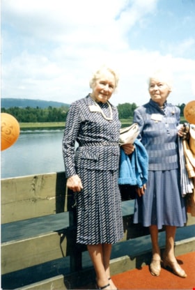
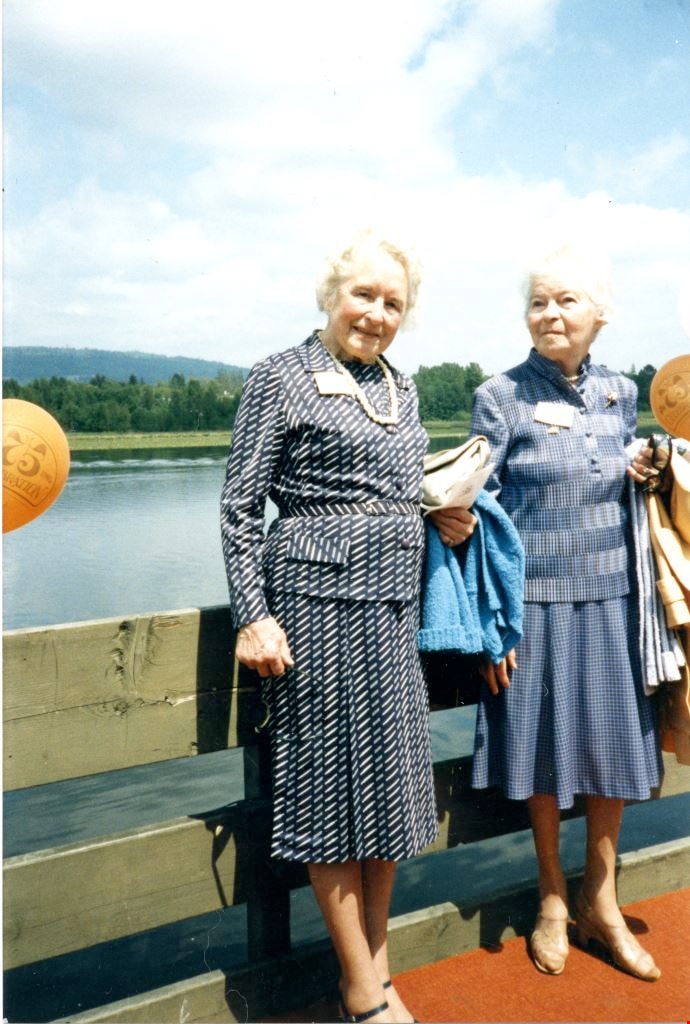
Miss Amy Leigh and Miss Mennie
https://search.heritageburnaby.ca/link/museumdescription5232
- Repository
- Burnaby Village Museum
- Date
- May 26, 1985
- Collection/Fonds
- Burnaby Girl Guides fonds
- Description Level
- Item
- Physical Description
- 1 photograph : col. ; 15 x 10 cm
- Scope and Content
- Photograph of Amy Leigh and Miss Barbara Mennie who were special guests at the 75th Burnaby Royal Area celebration on May 26, 1985 at the Burnaby Lake Pavillion. Miss Leigh spoke to all the girls at the ceremony. Miss Leigh arrived from England in 1913 and by 1914 at the age of 17 years, Miss Leigh…
- Repository
- Burnaby Village Museum
- Collection/Fonds
- Burnaby Girl Guides fonds
- Description Level
- Item
- Physical Description
- 1 photograph : col. ; 15 x 10 cm
- Scope and Content
- Photograph of Amy Leigh and Miss Barbara Mennie who were special guests at the 75th Burnaby Royal Area celebration on May 26, 1985 at the Burnaby Lake Pavillion. Miss Leigh spoke to all the girls at the ceremony. Miss Leigh arrived from England in 1913 and by 1914 at the age of 17 years, Miss Leigh went forward to officially register the 1st Burnaby Guide Company. Miss Mennie was a guide with the 1st Burnaby Guide Company and soon after became a Guide Leader with Miss Leigh.
- Geographic Access
- Burnaby Lake
- Accession Code
- BV016.49.124
- Access Restriction
- No restrictions
- Reproduction Restriction
- May be restricted by third party rights
- Date
- May 26, 1985
- Media Type
- Photograph
- Historic Neighbourhood
- Burnaby Lake (Historic Neighbourhood)
- Planning Study Area
- Burnaby Lake Area
- Notes
- Transcribed title from label in scrapbook
- Note in blue ink on verso of photograph reads: "Amy Leigh / May 26/85 / Burn Lake Pavillion"
Images
![Interview with Julie Lee by Denise Fong February 6, 2020, [1920-1992] (interview content), interviewed Feb. 6, 2020 thumbnail](/media/hpo/_Data/_BVM_Images/2017/2017_0024_0027_001.jpg?width=280)
Interview with Julie Lee by Denise Fong February 6, 2020
https://search.heritageburnaby.ca/link/museumdescription12338
- Repository
- Burnaby Village Museum
- Date
- [1920-1992] (interview content), interviewed Feb. 6, 2020
- Collection/Fonds
- Burnaby Village Museum fonds
- Description Level
- Item
- Physical Description
- 1 sound recording (mp3) (00:53:46 min.)
- Scope and Content
- Recording consists of an interview with Julie Lee conducted by Burnaby Village Museum researcher Denise Fong. Julie Lee shares information about her mother, Suey Ying Jung's (Laura's) experiences growing up as a Chinese Canadian on a farm in Burnaby during the 1920s and 1930s. She also shares some …
- Repository
- Burnaby Village Museum
- Collection/Fonds
- Burnaby Village Museum fonds
- Series
- Museum Oral Histories series
- Subseries
- Chinese Canadians in Burnaby subseries
- Description Level
- Item
- Physical Description
- 1 sound recording (mp3) (00:53:46 min.)
- Material Details
- Interviewer: Denise Fong Interviewee: Julie Lee Location of Interview: Home of Julie and Cecil Lee Interview Date: February 6, 2020 Total Number of Tracks: 1 Total Length of all Tracks: 00:53:46
- Scope and Content
- Recording consists of an interview with Julie Lee conducted by Burnaby Village Museum researcher Denise Fong. Julie Lee shares information about her mother, Suey Ying Jung's (Laura's) experiences growing up as a Chinese Canadian on a farm in Burnaby during the 1920s and 1930s. She also shares some information about her father Puy Yuen Chan. 0:00- 01:47 Julie Lee provides background information on her families’ connection to Burnaby and conveys how her maternal grandparents farmed a five acre lot at Still Creek and Douglas Road. Her grandparents grew vegetable produce and operated a piggery at this location. Her mother, Suey Ying Jung (Laura) was the middle child between two older sisters, Maida and Annie and her two younger brothers Gordon and Harry. They were all born at home and educated at Edmonds Elementary School. 01:48- 11:47 Julie provides some background information about her mother, the friendships she made growing up, when she got married and places that she lived. She tells of her mother marrying in 1942 at age 30 years, moving to Fraser Mills and then onto Maillardville in 1958. There was easy access to the Interurban tram so her mother was able to have a social life with others in Vancouver’s Chinatown. She says that many of the only existing photographs of the family living on the farm at Still Creek and Douglas Road can be attributed to her mother’s friend Lil Mau [sic] who owned a camera. The farm was sold around 1949 when her grandparents moved to East Vancouver. While operating the farm, her grandparents only hired Chinese workers who spoke the same language and ate the same foods as them. Despite this, her grandparents made friends with the Collin’s family who assisted them in adjusting to the Canadian way of life. Julie tells that her mother’s sister Maida and brother in law lived with them at Fraser Mills. Her mother’s sister Maida had nine children so Julie’s mother helped her in raising them. 11:48 – 16:53 - Julie talks about racial prejudice towards the Chinese in Burnaby during the 1920s and 1930s. She says that for the most part, her mother’s family had a very insular life on the farm and mainly socialized only within the Chinese community. Julie tells of how she recently became aware of a memoir “The Way it Was”, written by Burnaby resident, Fannie Waplington. The memoir is held as part of the Burnaby Village Museum collection. In the memoir, Fannie Waplington tells of how she was forbidden from visiting Julie’s mother on their farm due to her ethnic background. Julie conveys that it seems like it was a missed friendship for both her mother and Fannie. 16:54 – 22:30 Julie describes what school life was like for her mother and what she may have done outside of school. Her mother attended Edmonds School in the 1920s up to Grade 7 or Grade 8. Julie explains that Asian girls were never offered the opportunity to pursue higher education while her mother’s brothers continued with their education attending Vancouver Technical School. Her mother continued to work on the farm until she was married cooking for workers and helping her mother. Outside of school, she may have helped with looking after nieces and nephews, played cards and mahjong. She says that her mother continued to play cards with her own children and was a skilled knitter into her 80s. 22:31 – 30: 53 Julie tells of what she knows about the Chinese workers on the farm and Fraser Mills and what they did on the weekends. She figures that many may have played card games to pass the time and at Fraser Mills gambling occurred. Fishing was a highlight for her father and she recalls him fishing sturgeon. Single workers may have gone into Vancouver on the weekends. Julie says that her parents had a hobby farm while living at Fraser Mills and that they grew enough garlic to sell in Chinatown. She thinks that before living at Fraser Mills, her mother must have went to Chinatown quite a bit, assisting with banking and enjoying a social life. Julie shares that her father, Puy Yuen Chan came to Canada from China at twelve years of age but working as a shingle packer, he never learned to speak English. She figures that her parents must have met at Fraser Mills while her mother was visiting her sister Maida. 30:54 – 37:33 Julie describes her mother as the cook, caregiver and the “one man show”. She says that her mother enjoyed cooking traditional Chinese recipes. Julie talks of her own cooking and gardening skills which she may have inherited from her parents including her large patch of garlic. 37:34- 40:23- Julie is asked as to whether her mother attended Chinese school and says that she had some Chinese schooling. She could read and write a little but didn’t attend a formal school as far as she knows. Julie shares some background information on her own husband Cecil, who grew up in East Vancouver. She shares that Cecil’s family went back to China from 1931 until 1939 when they returned to Queensborough. Cecil attended Chinese school in New Westminster. 40:24 – 42:19 Julie speaks briefly about what type of medical care her mother and her family had. She relates that all births took place at home and they accessed a Chinese herbalist in Chinatown. Hospitals were accessed in 1950s—1960s. The family did use Western doctors that were insured under the medical system. She recalls growing up and having to drink a particular herbal brew at least once a month to stay well. 42:20- 46:47 Julie describes how her parents stayed connected with their families in China. She says that her mother’s family didn’t stay in touch with relatives in China and that her uncles rejected anything to do with the past. On her father’s side they maintained a connection with cousins. She recalls that her father, Puy Yuen Chan supported some of his relatives back home in China and stayed in touch with some. Her mother, Laura travelled to China in 1991 and 1992 and connected with some relations on Julie’s father’s side. 46:48- 53:46 In this segment, Julie speaks of her mother’s character being very self-assured, independent and goal oriented. She feels that her mother valued being surrounded by her family and friends and felt very comfortable growing up in Burnaby and with the relationships that she had. She feels that her mother adapted to her roles being the last of four children on the farm and that she was very self-sufficient and determined.
- History
- Interviewee biography: Julie Lee (nee Chan) is the daughter of Suey Ying Jung (Laura) and Puy Yuen Chan. Her mother's family owned and operated a vegetable and piggery farm on Douglas Road near Still Creek in the early 1900s. Their farm was located in front of the Douglas Road interurban tram station. Her mother had two older sisters named Maida and Annie and two younger brothers Harry and Gordon. Her mother was born in 1912 and left the farm for Fraser Mills when she was married in 1942. Julie grew up with her parents and siblings on the Fraser Mills site during the 1940s and 1950s. Interviewer biography: Denise Fong is a historical researcher at Burnaby Village Museum. She has degrees in Anthropology (BA) and Archaeology (MA), and is completing her doctoral degree at UBC in Interdisciplinary Studies. Her primary research interests are in Chinese Canadian history and critical heritage studies. She is the co-curator of BVM’s “Across the Pacific” exhibition, and the Museum of Vancouver’s “A Seat at the Table – Chinese Immigration and British Columbia”.
- Creator
- Burnaby Village Museum
- Names
- Lee, Julie Cho Chan
- Chan, Puy Yuen
- Jung, Suey Ying "Laura"
- Wong, Suey Fong "Maida" Jung
- Jung, Suey Cheung "Harry"
- Jung, Suey Yook "Gordon"
- Jung, Gee Shee
- Jung, Chung Chong
- Jong, Suey Kin "Annie" Jung
- Responsibility
- Fong, Denise
- Geographic Access
- Douglas Road
- Accession Code
- BV020.6.2
- Access Restriction
- No restrictions
- Reproduction Restriction
- No known restrictions
- Date
- [1920-1992] (interview content), interviewed Feb. 6, 2020
- Media Type
- Sound Recording
- Historic Neighbourhood
- Burnaby Lake (Historic Neighbourhood)
- Planning Study Area
- Douglas-Gilpin Area
- Related Material
- See also BV018.16.1
- Scan Resolution
- 1000
- Scan Date
- 01-Oct-2017
- Scale
- 96
- Notes
- Title based on contents of interview
- Photograph info: Suey Ying (Laura) with produce baskets [between 1940 and 1942]. BV017.24.27
Images
![Interview with Julie Lee by Denise Fong February 6, 2020, [1920-1992] (interview content), interviewed Feb. 6, 2020 thumbnail](/media/hpo/_Data/_BVM_Images/2017/2017_0024_0027_001.jpg)
Audio Tracks
Interview with Julie Lee by Denise Fong February 6, 2020, [1920-1992] (interview content), interviewed Feb. 6, 2020
Interview with Julie Lee by Denise Fong February 6, 2020, [1920-1992] (interview content), interviewed Feb. 6, 2020
https://search.heritageburnaby.ca/media/hpo/_Data/_BVM_Sound_Recordings/Oral_Histories/2020_0006_0002_001.mp3![Antique cars on Hill Street, [198-] thumbnail](/media/hpo/_Data/_BVM_Images/2020/2020_0005_0934_001.jpg?width=280)
Antique cars on Hill Street
https://search.heritageburnaby.ca/link/museumdescription13743
- Repository
- Burnaby Village Museum
- Date
- [198-]
- Collection/Fonds
- Century Park Museum Association fonds
- Description Level
- Item
- Physical Description
- 1 photograph : col. ; 10 x 15 cm
- Scope and Content
- Photograph of Hill Street inside Heritage Village Museum. Visitors are gathered along the street to view antique cars and buildings are decorated with red, white and blue bunting.
- Repository
- Burnaby Village Museum
- Collection/Fonds
- Century Park Museum Association fonds
- Description Level
- Item
- Physical Description
- 1 photograph : col. ; 10 x 15 cm
- Scope and Content
- Photograph of Hill Street inside Heritage Village Museum. Visitors are gathered along the street to view antique cars and buildings are decorated with red, white and blue bunting.
- Names
- Burnaby Village Museum
- Geographic Access
- Deer Lake Avenue
- Accession Code
- BV020.5.934
- Access Restriction
- No restrictions
- Reproduction Restriction
- No known restrictions
- Date
- [198-]
- Media Type
- Photograph
- Historic Neighbourhood
- Burnaby Lake (Historic Neighbourhood)
- Planning Study Area
- Morley-Buckingham Area
- Scan Resolution
- 600
- Scan Date
- 22-Sep-2020
- Scale
- 100
- Notes
- Title based on contents of photograph
Images
![Antique cars on Hill Street, [198-] thumbnail](/media/hpo/_Data/_BVM_Images/2020/2020_0005_0934_001.jpg)
Oakalla prison correctional officer 4214
https://search.heritageburnaby.ca/link/museumdescription16688
- Repository
- Burnaby Village Museum
- Date
- [198-]
- Collection/Fonds
- Oakalla Prison collection
- Description Level
- Item
- Physical Description
- 1 photograph : b&w ; 4.5 x 5 cm
- Scope and Content
- Photograph of an unidentified correctional officer of Oakalla Prison. Photograph may have been used to identification purposes. Officer has short hair and mustache, dressed in uniform with the numbers "4214" displayed below.
- Repository
- Burnaby Village Museum
- Collection/Fonds
- Oakalla Prison collection
- Description Level
- Item
- Physical Description
- 1 photograph : b&w ; 4.5 x 5 cm
- Scope and Content
- Photograph of an unidentified correctional officer of Oakalla Prison. Photograph may have been used to identification purposes. Officer has short hair and mustache, dressed in uniform with the numbers "4214" displayed below.
- History
- Salvaged from Oakalla Prison Farm site in October 1991
- Subjects
- Public Services - Correctional
- Geographic Access
- Oakmount Crescent
- Street Address
- 5220 Oakmount Crescent
- Accession Code
- BV991.45.417
- Access Restriction
- Restricted access
- Reproduction Restriction
- May be restricted by third party rights
- Date
- [198-]
- Media Type
- Photograph
- Historic Neighbourhood
- Burnaby Lake (Historic Neighbourhood)
- Planning Study Area
- Oakalla Area
- Scan Resolution
- 1000
- Scan Date
- June 7, 2021
- Scale
- 100
- Notes
- Title based on contents of photograph
- Note in pencil on verso of photograph reads: "Pohl"
Oakalla prison correctional officer 2765
https://search.heritageburnaby.ca/link/museumdescription16689
- Repository
- Burnaby Village Museum
- Date
- [198-]
- Collection/Fonds
- Oakalla Prison collection
- Description Level
- Item
- Physical Description
- 1 photograph : b&w ; 4.5 x 5 cm
- Scope and Content
- Photograph of an unidentified correctional officer of Oakalla Prison. Photograph may have been used for identification purposes. Officer is dressed in uniform with the numbers "4214" displayed below.
- Repository
- Burnaby Village Museum
- Collection/Fonds
- Oakalla Prison collection
- Description Level
- Item
- Physical Description
- 1 photograph : b&w ; 4.5 x 5 cm
- Scope and Content
- Photograph of an unidentified correctional officer of Oakalla Prison. Photograph may have been used for identification purposes. Officer is dressed in uniform with the numbers "4214" displayed below.
- History
- Salvaged from Oakalla Prison Farm site in October 1991
- Subjects
- Public Services - Correctional
- Geographic Access
- Oakmount Crescent
- Street Address
- 5220 Oakmount Crescent
- Accession Code
- BV991.45.418
- Access Restriction
- Restricted access
- Reproduction Restriction
- May be restricted by third party rights
- Date
- [198-]
- Media Type
- Photograph
- Historic Neighbourhood
- Burnaby Lake (Historic Neighbourhood)
- Planning Study Area
- Oakalla Area
- Scan Resolution
- 1000
- Scan Date
- June 7, 2021
- Scale
- 100
- Notes
- Title based on contents of photograph
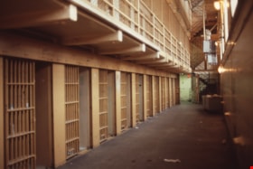
Oakalla cell block
https://search.heritageburnaby.ca/link/museumdescription17070
- Repository
- Burnaby Village Museum
- Date
- Mar. 1985
- Collection/Fonds
- Oakalla Prison collection
- Description Level
- Item
- Physical Description
- 1 photograph : col. slide ; 35 mm
- Scope and Content
- Photograph of the cell block inside Oakalla Prison.
- Repository
- Burnaby Village Museum
- Collection/Fonds
- Oakalla Prison collection
- Description Level
- Item
- Physical Description
- 1 photograph : col. slide ; 35 mm
- Scope and Content
- Photograph of the cell block inside Oakalla Prison.
- Subjects
- Public Services - Correctional
- Geographic Access
- Oakmount Crescent
- Street Address
- 5220 Oakmount Crescent
- Accession Code
- BV991.45.538
- Access Restriction
- No restrictions
- Reproduction Restriction
- May be restricted by third party rights
- Date
- Mar. 1985
- Media Type
- Photograph
- Historic Neighbourhood
- Burnaby Lake (Historic Neighbourhood)
- Planning Study Area
- Oakalla Area
- Scan Resolution
- 2400
- Notes
- Title based on contents of photograph
- note in black ink on slide frame reads: "OAKALLA / MAR 85
Images

![Main gate of Oakalla, [1985] thumbnail](/media/hpo/_Data/_BVM_Images/1991/1991_0045_0539_001.jpg?width=280)
Main gate of Oakalla
https://search.heritageburnaby.ca/link/museumdescription17071
- Repository
- Burnaby Village Museum
- Date
- [1985]
- Collection/Fonds
- Oakalla Prison collection
- Description Level
- Item
- Physical Description
- 1 photograph : col. slide ; 35 mm
- Scope and Content
- Photograph of the main gate of Oakalla Prison (Lower Regional Correctional Centre) with car outside of the entrance.
- Repository
- Burnaby Village Museum
- Collection/Fonds
- Oakalla Prison collection
- Description Level
- Item
- Physical Description
- 1 photograph : col. slide ; 35 mm
- Scope and Content
- Photograph of the main gate of Oakalla Prison (Lower Regional Correctional Centre) with car outside of the entrance.
- Subjects
- Public Services - Correctional
- Geographic Access
- Oakmount Crescent
- Street Address
- 5220 Oakmount Crescent
- Accession Code
- BV991.45.539
- Access Restriction
- No restrictions
- Reproduction Restriction
- May be restricted by third party rights
- Date
- [1985]
- Media Type
- Photograph
- Historic Neighbourhood
- Burnaby Lake (Historic Neighbourhood)
- Planning Study Area
- Oakalla Area
- Scan Resolution
- 2400
- Notes
- Title based on contents of photograph
- note in black ink on slide frame reads: "OAKALLA / MAIN GATE / c. 1985?"
Images
![Main gate of Oakalla, [1985] thumbnail](/media/hpo/_Data/_BVM_Images/1991/1991_0045_0539_001.jpg)
![Oakalla hospital, [1985] thumbnail](/media/hpo/_Data/_BVM_Images/1991/1991_0045_0540_001.jpg?width=280)
Oakalla hospital
https://search.heritageburnaby.ca/link/museumdescription17072
- Repository
- Burnaby Village Museum
- Date
- [1985]
- Collection/Fonds
- Oakalla Prison collection
- Description Level
- Item
- Physical Description
- 1 photograph : col. slide ; 35 mm
- Scope and Content
- Photograph of Oakalla Prison hospital (Lower Regional Correctional Centre).
- Repository
- Burnaby Village Museum
- Collection/Fonds
- Oakalla Prison collection
- Description Level
- Item
- Physical Description
- 1 photograph : col. slide ; 35 mm
- Scope and Content
- Photograph of Oakalla Prison hospital (Lower Regional Correctional Centre).
- Subjects
- Public Services - Correctional
- Geographic Access
- Oakmount Crescent
- Street Address
- 5220 Oakmount Crescent
- Accession Code
- BV991.45.540
- Access Restriction
- No restrictions
- Reproduction Restriction
- May be restricted by third party rights
- Date
- [1985]
- Media Type
- Photograph
- Historic Neighbourhood
- Burnaby Lake (Historic Neighbourhood)
- Planning Study Area
- Oakalla Area
- Notes
- Title based on contents of photograph
- Note in black ink on slide frame reads "Oakalla hospital / 1985?"
Images
![Oakalla hospital, [1985] thumbnail](/media/hpo/_Data/_BVM_Images/1991/1991_0045_0540_001.jpg)
![Lower Regional Correctional Centre, [1985] thumbnail](/media/hpo/_Data/_BVM_Images/1991/1991_0045_0541_001.jpg?width=280)
Lower Regional Correctional Centre
https://search.heritageburnaby.ca/link/museumdescription17073
- Repository
- Burnaby Village Museum
- Date
- [1985]
- Collection/Fonds
- Oakalla Prison collection
- Description Level
- Item
- Physical Description
- 1 photograph : col. slide ; 35 mm
- Scope and Content
- Photograph of the exterior of Oakalla Prison (Lower Regional Correctional Centre).
- Repository
- Burnaby Village Museum
- Collection/Fonds
- Oakalla Prison collection
- Description Level
- Item
- Physical Description
- 1 photograph : col. slide ; 35 mm
- Scope and Content
- Photograph of the exterior of Oakalla Prison (Lower Regional Correctional Centre).
- Subjects
- Public Services - Correctional
- Geographic Access
- Oakmount Crescent
- Street Address
- 5220 Oakmount Crescent
- Accession Code
- BV991.45.541
- Access Restriction
- No restrictions
- Reproduction Restriction
- May be restricted by third party rights
- Date
- [1985]
- Media Type
- Photograph
- Historic Neighbourhood
- Burnaby Lake (Historic Neighbourhood)
- Planning Study Area
- Oakalla Area
- Scan Resolution
- 2400
- Notes
- Title based on contents of photograph
- note in black ink on slide frame reads: "OAKALLA"
Images
![Lower Regional Correctional Centre, [1985] thumbnail](/media/hpo/_Data/_BVM_Images/1991/1991_0045_0541_001.jpg)
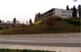
Burnaby Municipal Hall
https://search.heritageburnaby.ca/link/archivedescription86860
- Repository
- City of Burnaby Archives
- Date
- 1989
- Collection/Fonds
- Richard Hardy family fonds
- Description Level
- Item
- Physical Description
- 1 photograph : col. ; 9.5 x 15 cm
- Scope and Content
- Photograph of the second Burnaby Municipal Hall and the New Municipal Hall in the background on the left.
- Repository
- City of Burnaby Archives
- Date
- 1989
- Collection/Fonds
- Richard Hardy family fonds
- Physical Description
- 1 photograph : col. ; 9.5 x 15 cm
- Description Level
- Item
- Record No.
- 570-030
- Access Restriction
- No restrictions
- Reproduction Restriction
- Reproduce for fair dealing purposes only
- Accession Number
- 2014-16
- Scope and Content
- Photograph of the second Burnaby Municipal Hall and the New Municipal Hall in the background on the left.
- Subjects
- Public Services - Municipal Services
- Names
- Burnaby City Hall
- Media Type
- Photograph
- Notes
- Title based on contents of photograph
- Note in blue marker on recto reads: "1989"
- Historic Neighbourhood
- Burnaby Lake (Historic Neighbourhood)
- Planning Study Area
- Douglas-Gilpin Area
Images

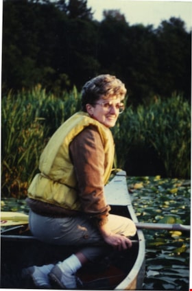
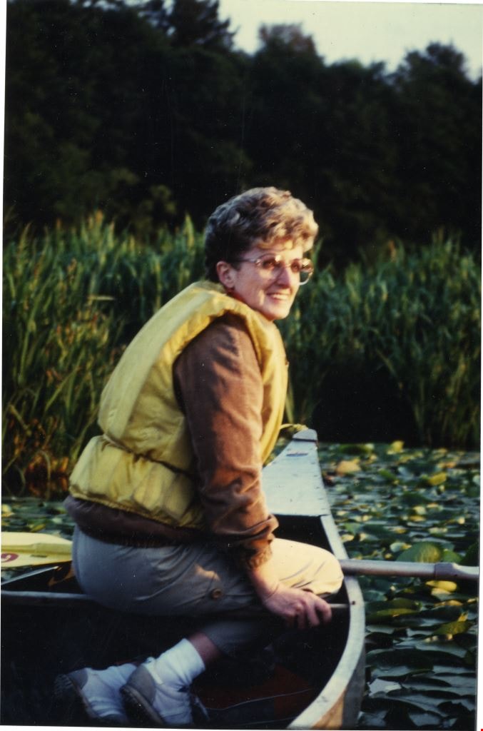
Doreen Lawson on Burnaby Lake
https://search.heritageburnaby.ca/link/archivedescription89072
- Repository
- City of Burnaby Archives
- Date
- 1988
- Collection/Fonds
- Doreen Lawson fonds
- Description Level
- File
- Physical Description
- 3 photographs : col. ; 15 x 10 cm
- Scope and Content
- File consists of two photographs of Doreen Lawson in a canoe on Burnaby Lake with a few other unidentified individuals and one photograph of Doreen Lawson standing next to an unidentified man looking over Burnaby Lake.
- Repository
- City of Burnaby Archives
- Date
- 1988
- Collection/Fonds
- Doreen Lawson fonds
- Physical Description
- 3 photographs : col. ; 15 x 10 cm
- Description Level
- File
- Record No.
- 605-008
- Access Restriction
- No restrictions
- Reproduction Restriction
- Reproduce for fair dealing purposes only
- Accession Number
- 2003-30
- Scope and Content
- File consists of two photographs of Doreen Lawson in a canoe on Burnaby Lake with a few other unidentified individuals and one photograph of Doreen Lawson standing next to an unidentified man looking over Burnaby Lake.
- Subjects
- Geographic Features - Lakes and Ponds
- Officials - Alderman and Councillors
- Recreational Activities - Canoeing
- Names
- Lawson, Doreen A.
- Media Type
- Photograph
- Notes
- Title based on content of photographs
- Note in black ink on verson of photographs reads: "Doreen Lawson '88"
- Historic Neighbourhood
- Burnaby Lake (Historic Neighbourhood)
- Planning Study Area
- Burnaby Lake Area
Images
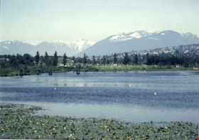
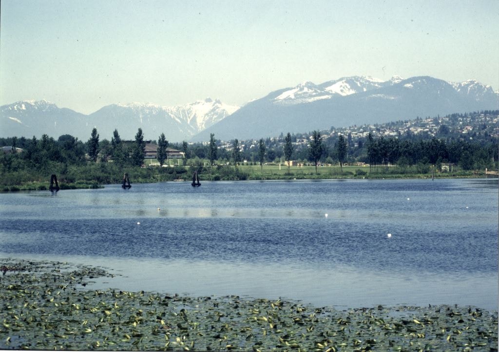
Burnaby Lake facing north
https://search.heritageburnaby.ca/link/archivedescription91575
- Repository
- City of Burnaby Archives
- Date
- 1982
- Collection/Fonds
- Doreen Lawson fonds
- Description Level
- Item
- Physical Description
- 1 photograph : col. ; 12.5 cm x 18 cm
- Scope and Content
- Photograph of Burnaby Lake facing north, with the Lions mountains visible in the distance.
- Repository
- City of Burnaby Archives
- Date
- 1982
- Collection/Fonds
- Doreen Lawson fonds
- Physical Description
- 1 photograph : col. ; 12.5 cm x 18 cm
- Description Level
- Item
- Record No.
- 605-007
- Access Restriction
- No restrictions
- Reproduction Restriction
- No restrictions
- Accession Number
- 2003-30
- Scope and Content
- Photograph of Burnaby Lake facing north, with the Lions mountains visible in the distance.
- Media Type
- Photograph
- Photographer
- Lawson, Doreen A.
- Notes
- Title based on contents of photograph
- Notes in blue ink on verso of photograph read: "Burnaby Lake/Lions" and "#82"
- Historic Neighbourhood
- Burnaby Lake (Historic Neighbourhood)
- Planning Study Area
- Burnaby Lake Area
Images

Burnaby Lake Show / originals
https://search.heritageburnaby.ca/link/archivedescription91683
- Repository
- City of Burnaby Archives
- Date
- 1962-1995
- Collection/Fonds
- Doreen Lawson fonds
- Description Level
- File
- Physical Description
- 71 photographs : col. slides ; 35 mm
- Scope and Content
- File consists of photographs compiled by Doreen Lawson for a slideshow presentation about Burnaby Lake. Slideshow primarily depicts the wildlife and foliage of Burnaby Lake, including: the American coot, green-winged teal, bufflehead, heron, american bittern, barn swallow, barn owl, painted turtle,…
- Repository
- City of Burnaby Archives
- Date
- 1962-1995
- Collection/Fonds
- Doreen Lawson fonds
- Physical Description
- 71 photographs : col. slides ; 35 mm
- Description Level
- File
- Record No.
- 618-001
- Access Restriction
- No restrictions
- Reproduction Restriction
- May be restricted by third party rights
- Accession Number
- 2015-15
- Scope and Content
- File consists of photographs compiled by Doreen Lawson for a slideshow presentation about Burnaby Lake. Slideshow primarily depicts the wildlife and foliage of Burnaby Lake, including: the American coot, green-winged teal, bufflehead, heron, american bittern, barn swallow, barn owl, painted turtle, muskrat, Canadian goose, beaver, wood duck, bullrushes, yellow and white waterlilies, yellow iris, and loosestrife. Also included in the slideshow are photographs of the BC Wildlife rescue and fisherman working in the Brunette River.
- Subjects
- Geographic Features - Lakes and Ponds
- Animals - Birds
- Animals
- Geographic Features - Forests
- Media Type
- Photograph
- Photographer
- Lawson, Doreen A.
- Chapman, Fred
- Notes
- Transcribed title
- Title transcribed from sheets slides
- Photographs contents are identified on many of the slide cases within the file.
- Historic Neighbourhood
- Burnaby Lake (Historic Neighbourhood)
- Planning Study Area
- Burnaby Lake Area
Images


Burnaby Lake slide show
https://search.heritageburnaby.ca/link/archivedescription91684
- Repository
- City of Burnaby Archives
- Date
- 1976-1999
- Collection/Fonds
- Doreen Lawson fonds
- Description Level
- File
- Physical Description
- 85 photographs : col. slides ; 35 mm
- Scope and Content
- File consists of photographs compiled by Doreen Lawson for slideshow presentations about Burnaby Lake. Slideshow primarily depicts the wildlife and foliage of Burnaby Lake, including: the painted turtle, heron, American coot, coyote, barn owl, rainbow fry, Canadian goose, and beaver, as well as a v…
- Repository
- City of Burnaby Archives
- Date
- 1976-1999
- Collection/Fonds
- Doreen Lawson fonds
- Physical Description
- 85 photographs : col. slides ; 35 mm
- Description Level
- File
- Record No.
- 618-002
- Access Restriction
- No restrictions
- Reproduction Restriction
- May be restricted by third party rights
- Accession Number
- 2015-15
- Scope and Content
- File consists of photographs compiled by Doreen Lawson for slideshow presentations about Burnaby Lake. Slideshow primarily depicts the wildlife and foliage of Burnaby Lake, including: the painted turtle, heron, American coot, coyote, barn owl, rainbow fry, Canadian goose, and beaver, as well as a variety of scenic photographs of the Burnaby Lake shoreline with mountains and the Metrotown skyline in distance. Also included in file are photographs of people canoeing, kayaking, feeding geese, and participating in conservation activities including fencing trees and testing water levels. Photographs also depict the pipeline leading into Burnaby Lake, lake dredging equipment, and an oil slick.
- Subjects
- Geographic Features - Lakes and Ponds
- Animals - Birds
- Animals
- Geographic Features - Forests
- Media Type
- Photograph
- Photographer
- Lawson, Doreen A.
- Notes
- Title based on contents of photographs
- Note in black ink on recto of slide sheet photographs 618-002-1 : 618-002-9 originally housed in read: "Burnby Lake Slideshow"
- Note in black ink on recto of slide sheet photographs 618-002-10 : 608-002-19 originally housed in read: "Burnaby Lake / Rejects (My Fav!)"
- Photographs contents are identified on many of the slide cases within the file.
- Historic Neighbourhood
- Burnaby Lake (Historic Neighbourhood)
- Planning Study Area
- Burnaby Lake Area
Images
